
12 minute read
To Tempt Fate


By Capt. Ian T. Brown, USMC
ike all the pilots whose stories have graced the pages of this magazine, I never thought the day would come when I’d describe a mission where we tempted fate just a little too much. Still, I’d much rather write about our close call, than have someone else talk about us in a mishap report.
Advertisement
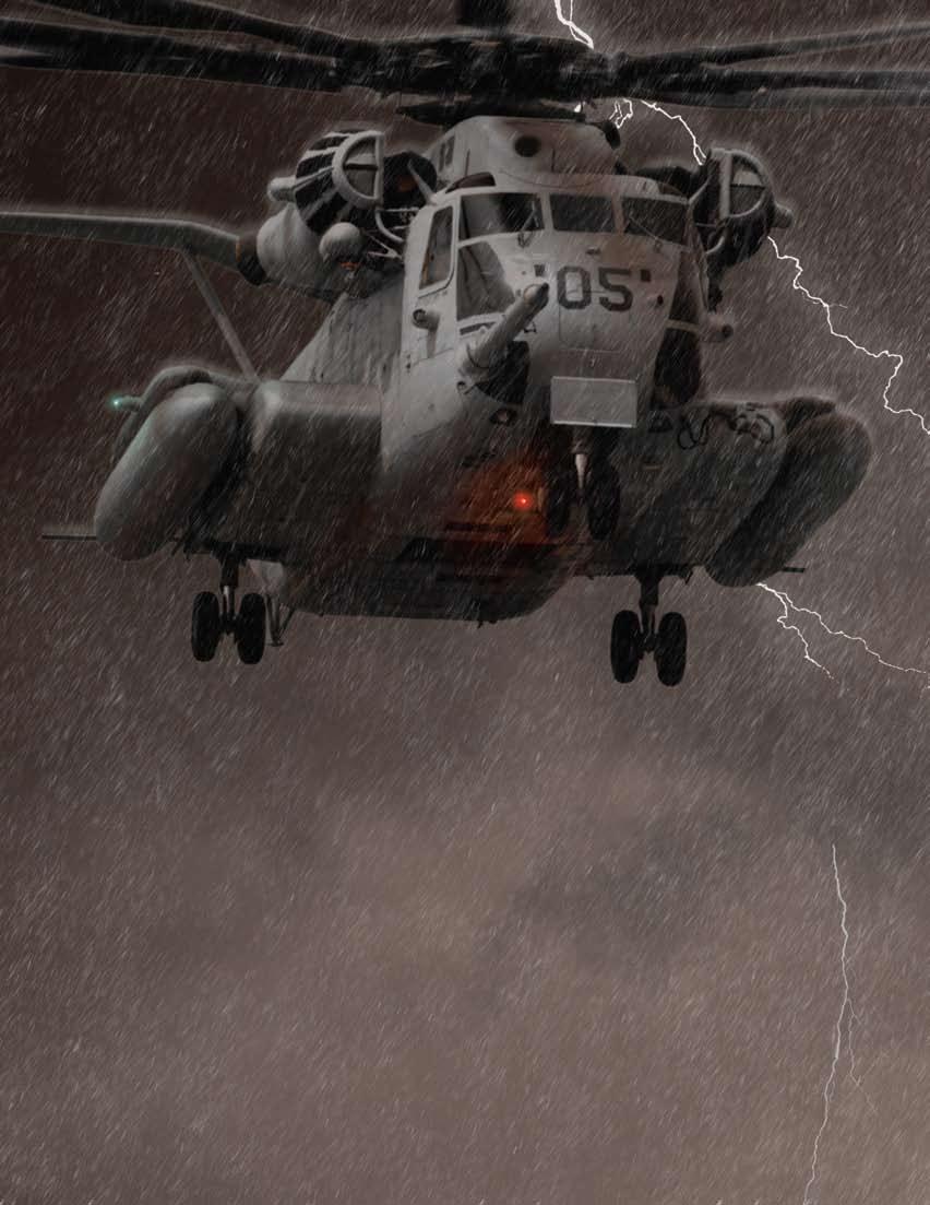
Our squadron had been flying CH-53E missions was 2,000-feet MSL, and the clouds were level with out of Al Asad Air Base for the last four months, and us, but by dropping down about 300 feet, we got below our task this day was no different from the countthe layer. We had better than three miles of visibility less other general-support missions we’ve flown. The around us, and had no problem seeing the ground. We helicopter-aircraft commanders (HACs) for our section could pick out the individual shower cells ahead of us, were among the most experienced in the unit: Our so we decided to work our way around them, as the section lead had 3,500 hours, and my HAC in Dash-2 cloud line was only a few miles deep. Heavy rain started had 2,100 hours. I was a new HAC with 720 hours, hitting our windshield, and we could see flashes of taking my turn in the copilot’s seat, and lead’s copilot lightning in the distance. This weather quickly cleared only had 560 hours. Everyone had deployed to Iraq up on the other side. multiple times, but this time was the first pump to The fun wasn’t over yet, though. A collapsing storm this part of Iraq for all four pilots. cell had stirred up a wall of dust to the west, so we
Our flight was divided into two parts: a quick hop skirted south a few miles before turning back on course. to a couple of zones just to our north, along the EuphraWe made it to KV without any more weather games. tes, followed by a long leg southwest out to Korean After landing, I ran into my fellow copilot while we got Village (KV) and back. Our forecast had a TEMPO line refueled. I joked that the return trip would be “interestcalling for rain, blowing dust, and reduced visibility ing” (I figured we just had flown through the worst of throughout the day, so we didn’t expect to accomplish it). I mistakenly thought the conditions were all blowing much tasking. However, the first leg went without a away from us. hitch. A little rain continued in the area, but we had We took off, and almost right away, things got good cloud ceilings and visibility. difficult. About 10 miles northeast of KV, we ran into
We were well ahead of time, so we got lunch and blowing dust that was picked up by strong gusting checked the weather. The outlook for the next 72 winds from our tail. We tightened up our formation hours called for poor weather throughout the AO, but and flew lower and slower. We kept the local eastthe morning hadn’t been as bad as predicted. So, we west, main supply route in sight, to maintain good launched with the intention of turning back if we ran reference with the ground. The dust cleared after into significant weather. a few minutes, and we trucked on. At the halfway
At about the halfway point, we saw a line of rain point, we switched off from KV approach to the showers stretching across the horizon. Our altitude direct-air-support center (DASC). However, that
same halfway point has a notorious “dead zone” for communications.
Because of our low altitude, we couldn’t raise the DASC to give them a position report or to get weather for home field. We still had the forecast from before we left, which didn’t call for anything worse than what we already had passed through. Conditions stayed clear until we made our turn northeast to head direct to Al Asad. About 30 miles southwest of the field, we saw dark clouds ahead of us, and thought, “Here we go again.”
I gave up the controls to the HAC, who’d flown us through the initial garbage. We turned up our anticollision and position lights so that Dash-1 could keep an eye on us—he did the same. This cloud was nothing like the first one.
We entered the cloud and it got darker, with brown-red clouds full of dust that the wind behind us had kicked up. We were at about 500 to 600 feet AGL, and still had a mile or two of visibility. The two HACs in the section were among the most experienced we had, so their “comfort level” was higher than ours. They felt confident pressing on, as long as we could see the ground around us and each other. The rain wasn’t just water; it was nasty, dirty, and mixed with dust as it seeped into our cockpit and started coating our instruments with slime.
After 15 minutes, we saw lightning in the clouds around us. My spidey-sense was tingling: As a rule, we avoid lightning and thunderstorms to the max extent possible, and here we were unknowingly pushing deeper into a large storm cell. Lead asked us to try and
get ATIS; home field was calling seven miles visibility, with an overcast layer at 6,000 feet. At the same time, about 17 miles out, we broke into a lighter area and thought we’d have an easier time ahead. We’d only gone through one line of weather on the outbound leg. Conditions around us, combined with ATIS, led us to believe the weather would improve.
This clear area simply was a lull in the storm. The rain showers we’d passed through on the outbound leg were the tail of a larger, unforecast storm system developing to the north, and pushing down from northwest to southeast, toward Al Asad. We were headed right into the storm and didn’t know it. At this point, we got our only positive communication with the DASC. We told them where we were and requested the switch to Al Asad tower. The DASC gave us permission to switch frequencies but didn’t mention anything about the weather coming from the northeast. We didn’t ask, because we believed we already had gone through the heavy stuff.
We rolled to tower’s frequency and called them but got only static. Switching to ground control, we asked for current conditions over the field, and they gave us winds and altimeter setting but no visibility info. We repeated our call, because visibility was what we were most concerned about. They replied with, “One mile to the west, seven to the east.”
We were 10 miles out. The weather seemed to be coming down on the field, but even with one-mile visibility, we could land special VFR; we still had 500/1. At five miles, we were handed off to tower, whom we again had trouble raising. We started to get heavy rain, and it became increasingly difficult to see our lead aircraft, lights and all, through the water, clouds, and lightning. Two miles out, tower reported half-mile visibility. We then managed to arrive over the field at exactly the same time as the heart of the storm. We were within a mile of the runway when tower told us visibility was one-sixteenth of a mile. I saw two lights to our left, and that was the last time I had the ground in sight for 10 long minutes.
Lead had been reduced to a dark smudge with flashing lights on our rain-beaten windscreen, but he still was flying straight and level amid the roiling clouds around us. Our HAC was determined to hang on to Dash-1, because he was the one anchor we had left in the storm. But, with no ground reference, and heavy rain and lightning getting worse around us, lead no longer was confident we safely could accomplish anything together. He kissed us off and told us to divert to Al Taqaddam. We called back that we still had him in sight, but he repeated his order to dissolve the flight and to get radar vectors to Al Taqaddam.
Lead said he would stay at 2,000 feet MSL and turn east to head direct to our divert. We broke left to 330 degrees and climbed to 3,000 feet MSL, turned on all our anti-icing gear, and both aircraft switched to approach. We got an “ice detected”
caution light—not a great sign. Approach heard our call first and told us to come to a southeast heading toward Al Taqaddam. However, we knew our lead was somewhere on that bearing to our right, and we had to make sure we were deconflicted with him, so we didn’t run into him.
The controllers chewed on that for a second, as we continued our turn. At the same time, lead had completed their turn and was headed southeast. After two or three minutes, they broke out into VMC conditions and pressed to a local checkpoint to hold and wait for us. Our left turn took us into the strongest part of the storm. We were engulfed in angry, red-brown clouds, surrounded by flashes of lightning. The rain, which suddenly turned into hail.
Things then got about as bad as they could. Approach told us to “ident” ourselves on their radar screen. I just had hit the switch that pinged us on their scopes, when the HAC told me to push the speed-control levers (SCLs) full forward, because we
were drooping “turns” (this means the rotor is slowing down and losing its ability to provide lift).
Our rotor tachometer showed eight percent below its normal operating range. I ran the SCLs full forward and glanced at our vertical-speed indicator to gauge the effect. I saw we were coming down out of the clouds at about 1,000-feet-per-minute, even with full collective and increased turns.
Approach control said something over the radio, but the HAC cut him off and declared an emergency because we were rapidly losing altitude. He ordered the crew chiefs to strap in. Those are about the last words any aircrew wants to hear. Looking at our attitude gyro, I saw our nose was pitching up to 20 degrees. I then watched our airspeed bleed down to 60 knots, and it was getting even slower. Either we had stalled out, iced up, or hit a massive downdraft. Regardless, we were in the worst possible weather and in an uncontrolled descent. The HAC had the controls and tried to stop our plunge out of the sky.
I thought, “We’re done, we’re going to put this in the dirt.”
I recalled a couple mishap reports: a grotesque combination of crashes two years ago that killed 30 Marines in a sandstorm, and another near-mishap where an aircraft entered stormy-icing conditions (like we had), iced up, and lost 4,000 feet of altitude in less than a minute of uncontrolled flight.
All of this had happened in less than 10 seconds, though it felt like an eternity. We lost about 650 feet of altitude, and then our descent stopped. We got our airspeed back up and finally completed the turn to the vector approach had given us. As we turned, I looked down through the clouds and glimpsed the lights on several barracks to the north side of the field. The temptation to try and drop down through that “sucker hole” and find a place to land was strong. But, with the gusting winds (we later learned that wind gusts of 57 knots were recorded on the ground), frequent lightning, and horrible visibility, trying to do so would have killed us more certainly than our tumble through the clouds.
The ground quickly disappeared again, and we were back in the monster that was doing its best to toss us out of the sky. But, we were under control and on the course approach had given us. After a couple of minutes, the sky got lighter, and we picked up the ground through the clouds. We finally broke out into the clear several miles east of the field, cancelled our radar coverage, and looked to rejoin our lead aircraft and head east to our divert airfield.
About this time, our crew chief piped up and told us to pull back the turns because we’d been running our engines at max power ever since pushing the SCLs forward. I looked at the instruments and saw the engine temperatures definitely were redlined. However, they are designed to operate at high temps long enough to give you emergency power when you need it. Well, we needed it, and we certainly would rather have burned the engines off the aircraft before putting it into the ground. We found Dash-1, joined up, and headed to Al Taqaddam.
We landed, shut down, and inspected the aircraft. Apart from shedding all of our blade tape (heavy tape put on the leading edges of all the main rotors to protect them from wear), the birds were fine. We now had to tie them down before the storm bore down on our divert field. It rolled in behind us, maybe 10 minutes after we’d landed. We started putting the blade ropes in just as the front edge of the storm hit, so we had to tie down the helicopters in a blinding sandstorm with howling winds. We then went to eat and to find a place to sleep. The trip home the next day was mercifully uneventful.
When everything had calmed down, the pilots discussed the events. Several times we could have thrown in the towel and turned around well before we got into the worst weather any of us ever had encountered. The experience and flying skills of our two HACs probably saved us from becoming another mishap, but we shouldn’t have put ourselves in a position to have to use those superior skills.
We’d had the worst of everything: heavy turbulence, high winds, freezing temperatures, rain, hail, zero visibility, and lightning all around us. Lesser weather has killed people out here. We all have a new respect for the weather and TEMPO line in this AO. No longer does it mean “maybe it will, maybe it won’t.” In Iraq, a TEMPO line means that it is likely you will see that weather. Also, we learned to consider the limitations of ATC, communications, and weather-predicting capabilities in such a vast area.
Capt. Brown flies with HMH-361.


