NILOUFAR MASHHADI
URBAN DESIGN PORTFOLIO


Tactical Urbanism, an approach to the realization of a dynamic and participatory urban space; Case study: Design of Rasteh Koocheh Street. Designing and Zanjan


and organizing
Street


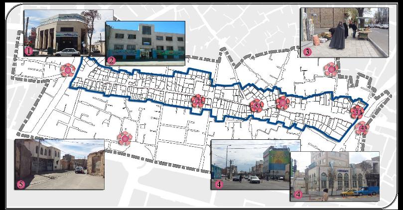
Rasteh Kucheh is located in is located close to the city center of Tabriz which connects two main streets, Azadegan and Jomhori Eslami. The site was selected as it sits on the boundary of the historic city center and the residential inner city and represents some brownfields for future development. It is one of the oldest streets in Tabriz and some historical places such as Bazar, Constitution House of Tabriz, and Jameh mosque of Tabriz are embedded in it.
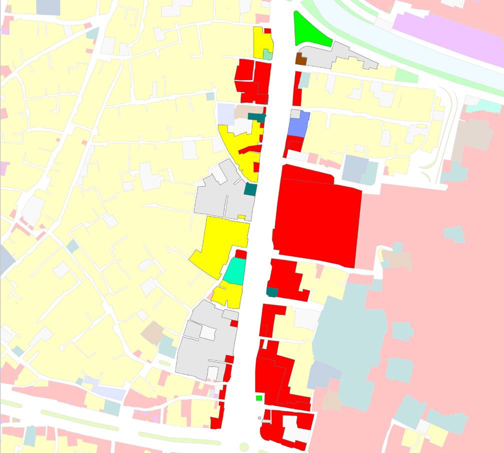

The map represents that the street has commercial land use for most. It also illustrates that the site has residential uses in its immediate context.
Although there are different types of activities on this street during the day such as walking, shopping, and talking, the street becomes useless at night.


By capturing the serial vision, it is clear that sidewalks have some problems like a shortage of seating places, and interference between motorcycles and pedestrians.


As it is clear, there are three key points where people passed. The reason for this is the barrier in the middle of the street which makes people to use some special points.
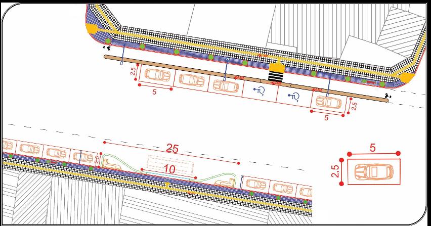
As is evident in the picture, on the east of the street there is street parking, and on the west side, there are bus stops, on both sides, there are two lanes for driving.

Converting inactive frontage to active by adding some street furniture to bring residents out.

Establishing a food van to make a food plaza for gathering people and having 24-hour activities.


Converting the alley to a footpath to reduce the cars and provide legibility to Jame mosque.
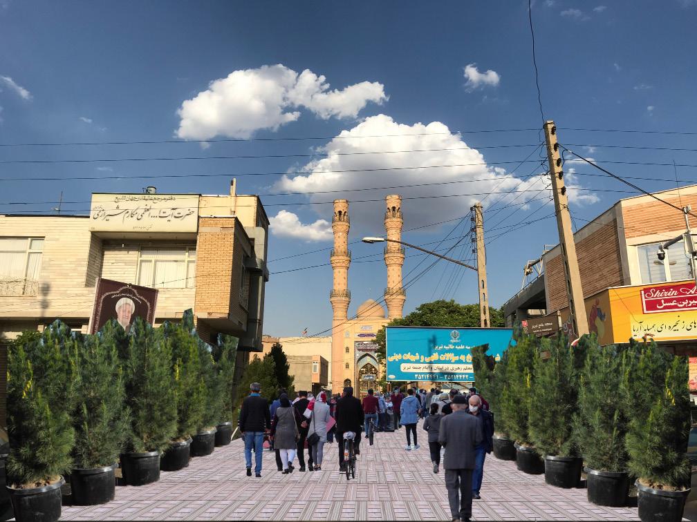


Providing special lanes for bicycles to guarantee pedestrian safety.


Using color to revitalization and hide the old facet.


Add color and furniture in order to activate frontages.

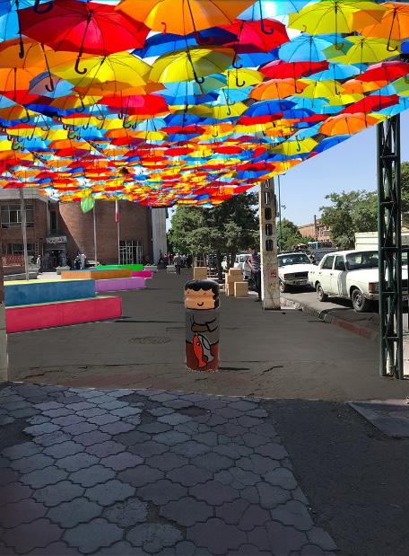
Using umbrellas to provide shade in open spaces, and using graffiti to change concrete structures.
At strategic intervals, vending areas for temporary vendors are provided.

Preparing bus stops for cold weather and the disabled to encourage using public transportation.

Seating will be placed at the required interval for resting.

Shaded seating space


Seating is placed at the required interval for resting.

At strategic intervals, vending areas for temporary vendors are provided.

Shaded seating space
the
By widening the footpath, there will be proper space for shaded seating places. Food Plaza


For encouraging individuals to ride their bikes, there will be parking for bicycles to keep them safe.
Preparing bus stops for cold weather and the disabled to encourage using public transportation.


constructing a playground on the street we can encourage people of different age groups to gather and increase social interactions.


and organizing Zanjan Zeinabieh Street


Of the total area of 100,328.47 square meters, about 86.35% is for residential use, 0.40% for administrative use, about 0.5% for educational use, and also 2.96% of the uses are in the form of unbuilt. 5.08% is also dedicated to commercial use.


West Zainabieh Street (between Shahada Street and Motahari Street) is one of the important streets, which can reduce the traffic load in the area if properly designed. It is necessary to create potential around this area to respond to the needs of the citizens in this area. Considering that this street is currently a local street that passes through an area with predominantly residential use, it lacks specific and obvious points in the field of public spaces and meeting areas.
One of the main features of the access in the case study is the width of the accesses. As can be seen in the cross-sections of the street, it is possible to point out the narrow width of the roads, where only two cars can easily move side by side. According to observations, there is no traffic problem in the area, although, in some places due to improper planning and the presence of empty lands that are used as parking lots, we see temporary traffic on the street.


West Zainabiyah Street is a local street in the central part of the city, which is a communication route to connect arterial streets.


Almost all the street sides in the northern part are used as parking lots. There are also some empty spaces used as car parking in the areas indicated on the map. This creates problems for pedestrians and traffic flow.
In the studied area, it can be said that hangouts and meeting areas are not seen in this place, only the usual gatherings for children to play when they leave school and also at retail stores can be mentioned. And in addition, it is possible to mention the gathering of people in some special places at certain hours of the day and during the Moharram months in mosques (Mahdieh Mosque, Ghasemieh
Serial visions of the West Zainabiyah route are given in the following pictures. As can be seen from the pictures, the physical and functional quality, the presence of people in the space and the visual effects of the environment are completely different at different stages of the route.

• Low price of land and real estate compared to other areas of the city.
• Located in the middle of the city and close to the most important streets and activity zones.
• The presence of meeting areas due to the presence of places such as mosques and Takaya.
• Existence of commercial use on a local scale.

• Lack of social infrastructure and community spaces.
• Lack of recreational spaces and open spaces.
• Population density is extremely high in the area.
• Low light area.
• Lost spaces led to insecurity.
• Existence of dilapidated and abandoned buildings and unusable open spaces incompatible with the residential environment.
• Motorist and pedestrian interference.
• Deterioration of the fabric of the neighborhood and its instability against natural disasters
• Lack of vitality in public areas.
• Lack of a suitable route for disabled people.
Creating an active and vibrant urban space with various land-use activities that performs as a social, commercial and cultural hub in Zanjan. It is also create a more integrative and sustainable urban space with a green environment that invites diverse demographics into the area.
• Connectivity and accessibility
• Diversity and mixed-use
• Identity
• Environmental responsiveness
• The possibility of creating green spaces and parks and creating security with the presence of people .
• The possibility of creating 24-hours uses as the eyes of the street.
• The presence of the main streets of the city center around the area.
• The opportunity to improve visual qualities by using traditional elements in new facades.
• Creating a public arena in sync with the climate in the form of green spaces by utilizing the potential of the site.
• The opportunity to increase livability by planting vegetation along the street.
• More access points for pedestrians and cyclists from various directions to provide great accessibility.
• Provision of paved and seperated pedestrian footpath with sufficient lightining to enhance the safety and walkability.
• Variety of buildings in higher density.
• Mixed land-use activities to create diversity in the site.
• provide more active street frontages along the street and active edges to invite people.
• Provide a community centre and open space to engage society with social and cultural activities.
• High quality design with diverse activities.
• Pedestrian-orientad design to create a sense of place on a human scale.
• The need for a lot destroyed houses in the
• Loss of vitality due
• Lack of security due
• Traffic in the surrounding
• Loss of sight to destruction.
• Pedestrians’ lives pedestrians.
• Inability of resident
• Reducing environmental pollution.
• Maintaining and increasing the form of vegetation.
.•Design based on compatible architectural patterns with the climate.


of financial resources to organize and rebuild the the dilapidated context. due to lack of attractive uses. due to lack of proper lighting. surrounding area.
green and natural elements due to reduction or are in danger due to the interference of riders and resident households to participate financially.


In this option, the case study is generally considered as an urban street that facilitates the traffic of the city center.
Among the effective factors in the design of this street is the use of spatial contrast and the creation of multiple gathering spaces that attract the population, which leads to an increase in social interactions. With regard to the access design, a bicycle path along the street has been considered, as well as the appropriate location for public transportation stations in the middle of the street.


From the accessibility viewpoint providing security and facilitating the movement of pedestrians has been prioritized. The location of bus stations and on-street parking for the convenience of the users on both sides of the street has been considered. A two-way bicycle path with a width of 2 meters is installed on the north side of the street (for climate reasons). In order to preserve the identity, the proposed facade in this concept is a combination of traditional and modern facades.


In the first step, this scenario played a role in reducing the traffic load. Since one of the main goals in the design of this street is to facilitate movement and reduce the traffic load of the middle section, the street in this concept is considered as a one-way street. Also, in order to encourage the use of public transportation, a bus lane has been considered in the southern part of this street.
On both sides of the street, a bicycle lane with a width of one meter has been considered along the street.


The goal of the final design is reaching to environmentally space which is suitable for every demographics. considering a variety of land uses and preparing Using parks, mixed-use activities, and proper on-street people.


environmentally friendly urban demographics. This will happen by preparing a space for everyone. on-street parking for disabled


According to the map, on the northern side of the site, the texture is following the irregualar texture, while on the sothernn side it follows the grid form.
types of pavements cause problems in walkability for the disabled.
As it is evident in the given map, due to open spaces and unbuilt ground there is no enclosure on the site, this will be considered in the following designs.


As it can be drawn from the given map, it is clear that the largest proportion of the age of the building around the site are between 20 to 30 years old and they will be worn out in near future based on worn-out urban texture parameters in Iran..


places for trash. Lost spaces are used as places for accumulating trash. Monotonous sky line on the façade. Lack of harmony and connection between adjacent buildings.

Looking at the map in detail, it is clear that there is a hierarchy of streets on the site and its surrounding. It is also clear that there are 4 traffic nods and 3 landmarks. It is worth noting that all landmarks are located on one side.


Buildings around the site are mainly 1 floor with a proportion of 78 percent, followed by 2floors with almost 19 percent.


Looking at the given map, it is evident that as a whole the area is not safe. Some parts of the neighborhood are insecure, and drug dealers trade in some parts and low-light areas are spreading along the street. There is also some street parking which jeopardizes pedestrian safety. At the intersections, there is interference between motorists and pedestrians.


• The presence of Rajaei Park within the site.
• The possibility of gathering people and establishing social interactions in Rajai Park.
• Placement of 22 Bahman Highway as the main transit route in the middle part of the site.
• The presence of behavioral camps due to the presence of places such as the library, bus station, and cultural center.
• The presence of a playground for children.
• There are key views toward mountains and a mosque.
• Potential open spaces
• Creation of lively, safe, and active public spaces at night due to the abundance of recreational and sports uses.
• The possibility of planting deciduous and evergreen trees alternately along the city’s main streets, creating beautiful variability during the seasons.
• Being away from the pollution of the city center pollution.
• Low population.
• Low light.
• Incompatible functions.
• Polluting functions.
• Lack of street furniture.
• Low quality green infrastructure.
• Lack of social supervision in the area.
• Parking issue.
• Lack of the horizontal and vertical rhythms of the buildings to each other.
• Diminished legibility due to the lack of visual qualities.

• Decreasing the level of the underground water table due to unconventional use.
• Development of incompatible functions on the edge of the site.
• Loss of vitality due to lack of attractive uses.
• Lack of security due to lack of proper lighting.
• Lost spaces.
• Plan for future development that is compatible with the current functions and existing residential neighborhoods.
• Considering public spaces to maintain and increase its use as a people place for social interaction and commerce (i.e., a pleasant location to shop, eat, conduct business, relax, be entertained, etc.).
• Develop a unifying theme or other visual concept for the consistent streetscape.
• Provide adequate availability and access to park lands and recreational opportunities for residents of all ages to maintain and nurture a quality living environment and a family-friendly community.
• Consider development of streetscape/urban design standards to enhance the City’s visual/aesthetic appeal (e.g., design guidelines for landscaping, building facades, signage, entryway treatments, etc.).
• Consider development of a plan to creat the image and identity of Bande ghadim Foroudgah.
• Provide adequate lighting and visibility to enhance safety in public places.
• Encourage multi-modal transportation options by designating areas for their development (e.g., pedestrian, bicycling, bus, taxi, etc.).
• Improving visual quality by strengthening key views.
• Unifying the infrastructure and information system.


Using modules to create an identity concerning Islamic architecture.


Using roof gardens and balconies to add vegetation and environmentally friendly buildings.
Considering setbacks to provide proper views along the street.


Considering bus stops at required intervals.
In the design of bus stops, we use the same modules as buildings to provide identity through the street.


Seating spaces are provided at climate in Zanjan and also considering


As the area suffers from low lighting and it causes some problems with safety, we consider lights for both buildings and the street.
required intervals for resting and gathering about the cold considering vegetation and the same module to create identity.


Considering setbacks to provide proper views along the street.


Esteghlal Square is located in the western part of Zanjan and acts as an entrance. It has a library and playground in it but struggles with many problems.
Most land use around the square is belonging to residential, however, at the edges the land uses are mixed-use. It also illustrates that the site has residential uses in its immediate context.


There are different types of trees in the square which should be preserved. The south part of the square is shaded most of the time.

As it can be drawn from the cross-section there are 2 bus stops on each side of the square and there are trees in the middle of the square.


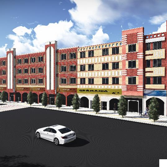
Uniform façade style of rectangular windows and arched entrance.

Pedestrian Crossing
pedestrian crossing placed at the bus stop.

Using different types of plant boxes with seating places in order to increase social interactions.
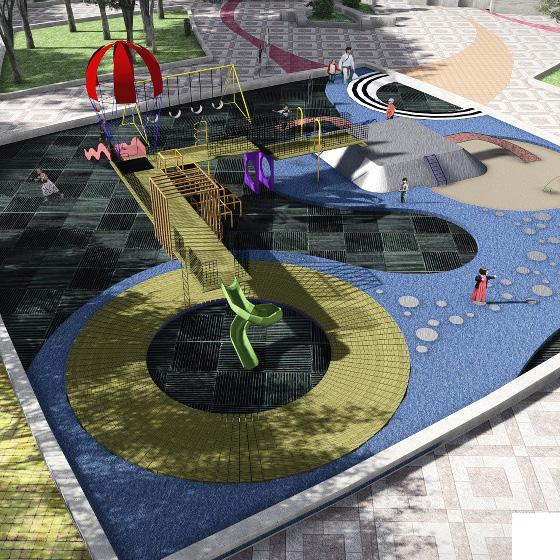
The playground should be equipped in order to encourage children to use this place.


Seating spaces are provided at required intervals for resting and gathering made from concrete. Plant boxes seperated people from walking people and motor traffic.

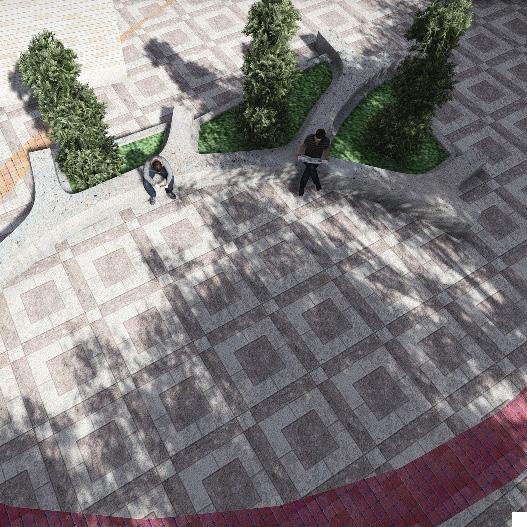
Seating spaces are provided at required intervals for resting and gathering made from concrete.

Designing a place where socially and environmentally beneficial.

