6 minute read
Walking


Walking world
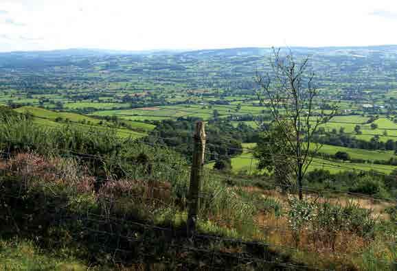
EXPLORING PENYCLODDIAU HILL FORT The Clwydian range of hills roughly run along the border between Denbighshire and Flintshire and have been designated an Area of Outstanding Natural Beauty.
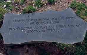
These lovely summits offer superb high-level walking on mostly good paths and give stunning views in all directions. Be prepared for steep ascents and descents if you intend to explore them, but generally they are friendly and benevolent hills which rise to their highest point on mighty Moel Ffamau at 1,821 ft/555 metres. From most areas of the Clwydian Hills towns such as Ruthin and Denbigh look tiny far below you and seem a long way away with the network of farmers’ fields that surround them make pretty patterns in the landscape. Offa’s Dyke Long Distance footpath follows the crest of the Clwydian range on the final stages of its epic 177 miles/285 km from Chepstow in the south of Wales to Prestatyn in the north. The Clwydian Hills also have a chain of high-level hill forts along them and todays walk climbs to the largest of these (which is also one of the biggest hill forts in Wales). This covers around 21 hectares and is on the 1,440 ft/440 metre summit of the hill of Plenycloddiau. This fort was subject to careful excavation and archaeological work between 2004 and 2010 as part of the Lottery funded ‘Heather and Hillforts project’. And between 2012 and 2018 the fort was used as a training opportunity for students of Liverpool University Archaeology Field School. Penycloddiau hill fort is of Iron Age but there some evidence that this hilltop was used as a burial mound from as long ago as the Bronze Age.
Even though this walk to the summit of Penycloddiau and the hill fort remains is quite short and starts from a high car park, it should not be underestimated as it is quite tough and traverses sections of open hillside. Choose a sunny settled day and treat the outing as a full-blown hill walk and you will enjoy a superb day out in this unique area.
THINGS YOU NEED TO KNOW
J 2.3 miles/3.70 kilometres J Time: Allow 2 - 2.5 hours J Start: Free car park at Coed Llangwyfan
between Moel Arthur and Penycloddiau.
This is on the minor road linking
Llandrynog (north of Ruthin) and the
B5429 to Nannerch (north west of Mold) and the A541
J Grid Ref: SJ 138668 J Nearest postcode: LL16 4NB J Ordnance Survey Map: Ordnance Survey
Explorer 265 – Clwydian Range
J What to expect: Despite being short this
route should be treated as a full-blown hill walk. Paths and tracks are generally good but there are some steep ascents and descents and some rough going in places.
The summit of Penycloddiau is high and offers no shelter so choose a good day of settled weather for the outing. You should wear boots and have full hill walking gear along with a stick in case of overgrown areas
J Suitable for: Experienced hill walkers J Dogs: OK on leads J Refreshments: Mold, Ruthin and Denbigh
all have shops, cafés and pubs
3
WALK DETAILS
START
From the car park go left of the Coed Llangwyfan sign and pass the Penycloddiau Hill Fort information board to pass by the right of two gates to take Offa’s Dyke footpath (the acorn sign). Beyond the gate rise on the path to leave it almost immediately by going half right to continue following Offa’s Dyke footpath. Follow the rising path in trees to soon rise more steeply and join a wall right. Continue rising with good views through the trees left. When you emerge
from the trees continue to climb now with a fence right and superb views left. When the angle eases make a short descent to pass a path junction left and a gate right. Rise beyond this on a narrower path. Continue rising to a stile by a gate and an Offa’s Dyke Footpath sign.
Points of interest on this section
J Offa’s Dyke Long Distance footpath – this National Trail follows the crest of the Clwydian range on the final stages of its epic 177 miles/285 km from Chepstow in the south of
Wales to Prestatyn in the north J The mountains you see to your left once out of the trees (on a clear day) are those of Snowdonia National Park
2) Cross the stile and take the good uphill path beyond (initially by a fence). As the fence bends left and descends, reach an Offa’s Dyke footpath marker and continue beyond it on a good wide grassy path. At the next junction follow the arrow and stay left. Rise past another Offa’s Dyke footpath marker to descend slightly and pass another Offa’s Dyke marker to then climb more steeply on the obvious path. Continue to the upper reaches of
5 2
ST AR T / FINI S H
Penycloddiau and the hill fort and follow the path as the angle eases to reach the summit cairn which is on a grassy burial mound surrounded by stones.
Points of interest on this section
J Penycloddiau Hill Fort – This is the largest hill fort in the
Clwydian Hills and one of the largest hill forts in Wales. It covers around 21 hectares and is on the 1,440 ft/440 metre summit of the hill of Plenycloddiau
3) Go ahead towards the obvious large mast to dip down and cross a ditch which is part of the hill fort. Rise a few paces to a path junction left of an Offa’s Dyke marker post. Here go left to walk along the fort ramparts. Follow the path to descend towards a fence and continue to reach it at a fence corner.
4) Continue ahead keeping the fence on your right and walk below the summit of Penycloddiau Hill Fort. At a stile right keep ahead to pass through a fence gap and continue with the fence right. Keep with the fence following a sunken path continuing to make a short steep rise to a fence corner. Go ahead to head downhill and pick up your outbound route descending it to cross the stile in the fence. Go left to descend to the gate left and the path junction right.
Points of interest on this section
J Clwydian Range – as you follow the fence and path you get great views of the Clwydian Hill Range. The highest point of the ridge is at Moel Ffamau at 1,821 ft/555 metres and is in view as you walk
5) Leave your outbound route to go right on a descending path passing through trees and ferns. Descend to reach a forest track at a junction and here go left. Follow this track to descend and pass by the gate to reach the car park and start. n
A WORD OF CAUTION Walking in the outdoors can be a strenuous activity and it is up to you to ensure that you are fit and healthy enough to undertake the route described and to approach the venture with caution and care. You should wear appropriate footwear and suitable clothing, take along food and drink plus carry the relevant map and a compass and be able to use it. The details given here are believed to be correct at the time of going to press. However, neither North Wales Magazine nor the author can accept responsibility for inaccuracies encountered.