7 minute read
A DAY IN THE LIFE OF A CFLO


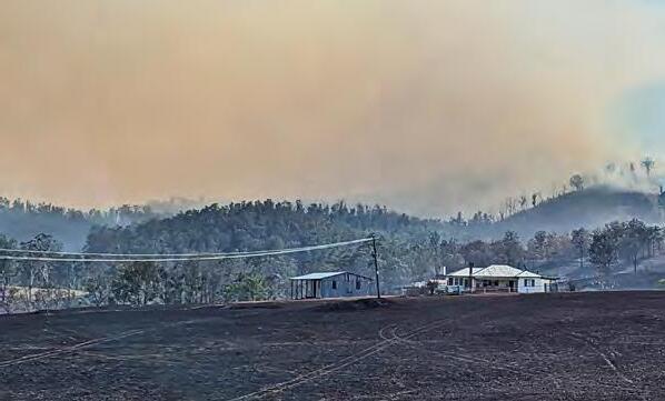
On 31 October 2023, the Christies fire crossed over the border from Wallangarra in Queensland to threaten the NSW town of Jennings. Locals were forced to take shelter at a local paddock as the fast-moving fire moved through the town.
RFS Community Field Liaison Officers (CFLOs) Catherine James and Kristie Baxter were the on-ground engagement between the RFS and the community before, during and after the fire. Below, Catherine shares the timeline of their day.
1030hrs:
We arrive and drive through the townships of Wallangarra and Jennings, visiting the local fire and police stations but they are unattended. Realising no main gathering areas have been organised, we speak to the Post Office.
1100hrs:
Kristie and I commence initial door knocks on several streets in Jennings to alert them to the fire burning across the border in Queensland (thought to be in Ballandean).
We advise locals of current and planned road closures around the Tenterfield area and discuss their plans to stay and defend or leave if the fire approaches. We communicate with those at risk to be alert and aware of any changing conditions.
1200hrs:
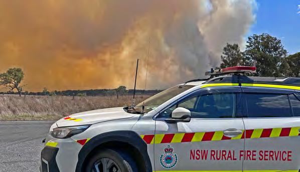
The fire conditions across the border to the northwest escalate. I advise the Community Liaison Officer in the Incident Management Team (IMT) and send photos through Firemapper.
We receive intel from a local farmer that the fire might be much closer than previously thought (at Saxby rather than Ballandean).
We immediately report the update to the IMT.
1230hrs:
Kristie and I make our way to Saxby-Reid Rd, Wallangarra. We take further photos and provide updates to the IMT.
We speak with QLD Police to see if there is any intel on the fire and see three QLD RFS trucks making their way to the fire trail area. Conditions continue to deteriorate as the fire moves south.
1300hrs:
We make our way up to the Wallangarra cemetery, which is the township’s only high point, to get a more accurate view of the fire movement.
Once there, we speak to several locals, advising them of the escalating fire conditions, then provide intel updates to the IMT.
1415hrs:
The conditions continue to deteriorate, and we identify that there are either two fires or two fire fronts. We report estimated distance and behaviour to the IMT.
Kristie and I proceed to doorknock most northwesterly houses in Wallangarra and then revisit owners on a couple of streets in Jennings to advise of the deteriorating conditions.
There is no designated Neighbourhood Safer Places (NSPs) in either township, so we decide on a cleared area where a large sign indicates the Queensland border, if needed.

1445hrs:
Locals alert us that the fire is heading east towards the Wallangarra main township. As the fire front runs across the New England Highway, we turn cars around to prevent them entering from the south and triage those exiting from the north.
A truck with its trailer fully engulfed in flames exits the fire front and spills debris onto the road. Behind it are several cars that have been burned along one side as the fire front crossed the road and caught them in its path.
I radio the sitrep to Firecom and request an ambulance for one member of the public with severe burns.
A RFS Category 1 tanker arrives on the scene to attend to the burning truck, while we direct cars south to escape the flames.
With additional fire appliances not yet on the scene, we proceed parallel to the fire path, advising residents who aren’t prepared to defend their properties that the fire has overrun the highway to the north, so the safest option is to leave now south towards Jennings.
Kristie and I attend to an elderly gentleman with mobility issues who is in the direct path of the fire, assisting him to a neighbour’s vehicle and giving them instructions to head south. Another elderly man living in the line of the fire needs immediate assistance after realising that his car is damaged, and house is not defendable.
RFS and Queensland Fire and Emergency Service (QFES) appliances start arriving on the scene as we help the gentleman into our vehicle and get him to safety.
RFS and QFES crews commence property protection along the north end of the townships.

1525hrs:
A QLD Emergency Warning to seek shelter is issued. We instruct all people already fleeing from Wallangarra township to head to the border sign area immediately.
We set up a road point on Merinda St near the Raleigh St intersection and divert all cars trying to leave via the New England Highway to the cleared area.
1529hrs:
RFS issue an Emergency Warning via text to ‘Shelter now –it is too late to leave’.
1530 – 1730hrs:
Both townships either side of the border affected by fire are now without power. More than 150 community members leave their properties to seek shelter at the border sign, as NSW Police and RFS Group Officers arrive on scene.
Kristie and I provide ongoing intel to the IMT and the State Operations Centre.
When the immediate fire danger passes, we purchase water and snacks at a local service station for the locals seeking shelter.
1730hrs:
Police permit people to return to their properties.
1800hrs:
The fire has passed down the eastern and western flanks of the townships. The New England Highway is closed in both directions as the fire crosses the road to the north and south of the townships.
1800 – 1900hrs:
The fire is downgraded from Emergency Warning to Watch and Act. We receive intel that the wind change will likely re-threaten the townships later that evening.
Kristie and I attend properties along the western edge of Wallangarra to check on residents who have returned.
We advise those living in the middle of Wallangarra and Jennings about the closure of the New England Highway in both directions and of the anticipated return of smoke and fire activity.
We discuss preparations with the locals who plan to defend (PPE, footwear, filling water buckets and watching for ember attack, etc.) and remind them of the makeshift NSP if needed.

1915hrs:
Fire activity picks up from the south. We door-knock on affected streets in Jennings. Multiple appliances begin arriving in anticipation of the fire approaching. Kristie and I assist an elderly couple who were about to go to bed and help to repack their campervan in the event of another Emergency Warning being issued.
We doorknock on several more streets to find out who is staying and defending and who is leaving to go to the border sign. We gather information including water tank capacity details and communicate to RFS crews on the scene.
2015hrs:
Kristie and I finish door knocking and attend the Wallangarra community hall, which has been opened for people to gather.
2015 – 2100hrs:
We remain with community members in the hall while awaiting intel on options for returning to Glen Innes or booking accommodation for the night in Stanthorpe.
2100hrs:
We drive south to Tenterfield and on to Glen Innes, reaching the Fire Control Centre at 2300hrs.
Thankfully, the Jennings/Wallangarra townships weren’t further threatened by this fire. We returned to visit them later in the week to provide support for a community meeting and to conduct building impact assessments.
We’re grateful that the townships had a good outcome, all things considered.