I rejoined the Streetsense on November 2023, a truly multi-disciplinary design firm with multiple offices across the globe. This time at the Washington DC headquarter, I was mainly working as an graphic designer, wayfinding designer and researcher. However, I was sti ll involved in urban planning, space design, branding and marketing projects.
CITY OF NEW ROCHELLE FLYER FOR SIGNAGE INSTALLATION
For my project with the City of New Rochelle, NY, I created an informative flyer graphic designed to streamline the permit acquisition process for signage installation. This fl yer employs a series of clear and visually appealing icons to guide users through each step, from reviewin g city codes to the final installation. It includes direct links for easy access to relevant regulations and a comp rehensive, step-by-step guide tailored for administrative use. The flyer ensures that both city officials and applicants can effortlessly navigate the permit process, understand requirements, and successfully complete the ir signage projects in a timely and compliant manner.
With the introduction of this flyer, the City of New Rochelle es timates a significant improvement in the efficiency of the signage permit process. Traditionally, this pro cedure, often seen as confusing and protracted, could extend from several months to nearly a year. However, the streamlined, step-by-step format and easy access to essential information provided by the flyer aim to sim plify the experience for all users. As a result, the city anticipates that the time required to obtain a permit will be reduced to a matter of weeks to a few months, ensuring a smoother and more efficient process for everyone invol ved.
HOW TO PERMIT + INSTALL A SIGN IN THE CITY OF NEW ROCHELLE
HOW TO INSTALL A SIGN IN THE CITY OF NEW ROCHELLE
KNOX ROAD STOREFRONT CONCEPTS, COLLEGE PARK, MD
REVIEW CHAPTER 270-SIGNS OF THE CITY CODE
CLICK ON CITY SQUAREDAPPLY FOR A PERMIT TO ACCESS THE CITY SQUARED WEBSITE
DETERMINE LOCATION + COMPILE DESIGN DOCUMENTS
PROVIDE A SIGN INSURANCE CERTIFICATE DOCUMENT CONSTRUCTION COSTS GATHER CONTACT INFORMATION
IF
VISIT THE M.A.C. WEBSITE TO COMPLETE PETITION APPLICATION
THE M.A.C. REJECTS YOUR APPEAL VISIT THE CITY SIGNS AND AWNINGS WEBSITE
WAIT FOR CORRESPONDENCE FROM CITY THE CITY REJECTS YOUR APPLICATION
OBTAIN PERMIT REJECTION LETTER CONGRATULATIONS! YOUR PERMIT IS ISSUED! THE CITY ACCEPTS YOUR APPLICATION
REQUEST AN APPEAL AT THE MUNICIPAL ART COMMISSION (M.A.C.)
SUBMIT THE PETITION + PAY THE APPLICATION FEE
ATTEND THE M.A.C. HEARING SESSION
OBTAIN INSPECTION CERTIFICATE THE M.A.C. ACCEPTS YOUR APPEAL
REQUEST AN INSPECTION BY CITY OFFICIALS
As a graphic designer for the “Pasadena Economic Development St rategy” project, I transformed extensive research materials and data into a visually engaging and easily digestible package. By translating complex text and statistical information into clear, compelling graphics, I ensured that the strategy was not only informative but also accessible to a wider audience. My work involved creat ing detailed charts, infographics, and visual narratives that highlighted key insights and strategic recommen dations. This approach made the economic development plan more appealing and comprehensible, aiding stak eholders in quickly grasping essential information and facilitating more informed decision-making.
APPROACH & METHODOLOGY
The City of Pasadena Economic Development Strategic Plan represents the culmination of a three-phase, eight-month planning process
Phase 1: Immersion & Discovery included site visits, fieldwork, stakeholder engagement through focus groups, and interviews with business owners, institutional leaders, City officials, and residents.
Phase 2: The Diagnostic resulted in a comprehensive analysis that combines qualitative and quantitative research methods to identify district-wide economic development challenges and opportunities in four key areas as follows: the Physical Environment, the local, regional, and visitor Market Demand, the Business Environment, and Administrative Capacity
Phase 3: The Strategic Plan, of which this document is the final deliverable, is a direct response to the opportunities and challenges identified in the first two phases of work
DIAGNOSTIC RESEARCH QUESTIONS
• Public Realm
• Private Realm
• Access + Visibility
• Regional + Local Market Trends
• Retail Demand Analysis
• Industry Sectors
• Destination Drivers
• Competitive Environment
• Commercial Nodes
• Partners
• Regulations
• Organizational Capacity
• Funding
Physical Environment
• What kinds of physical infrastructure improvements are necessary to support economic growth?
• What kinds of land uses, particularly along key corridors, are most appropriate to the sites available?
• What kinds of key redevelopment opportunities exist that should be identified and further leveraged?
• What industry sectors have competitive advantages that can be leveraged through the city’s programs and policies?
• What regional and local market trends and forecasts will influence opportunities for business growth and how can the city capitalize upon these?
• What are the levels of quality/gaps in existing assets and business mix that might inform targeted business and retail attraction and retention efforts?
Business Environment
• What are the characteristics of key destination drivers (retail, business, arts, culture, tourism), and what is needed to further enhance their economic impact?
• Where are the key nodes of concentrated business activity and what are their strategic characteristics that offer opportunities for focused investment?
• How are anchor institutions and businesses driving economic development in the city and how can they be further leveraged?
Administrative Environment
• What kind of funding, incentives, and strategic partnerships are available to support the city’s economic development goals and strategies?
• Do regulatory barriers exist that need to be addressed to support growth and address impediments to business activity?
• Who are the existing stakeholders, partners, and organizations that are critical to ensuring successful economic development outcomes?
Market Demand
The Diagnostic sought to answer the following research questions through a comprehensive analysis covering the following:
The five guiding principles outlined here serve as the policy framework for the City’s economic development efforts. While individual projects may evolve as EconDev works with partners on implementation, the projects, programs, and policies should continue to be measured against their service towards the framework outlined here
2.0
0
1
2
2
2
2
2
2
0.3 Explore local economic development entity formation
Explore the formation of an economic development entity that offers the city and its partners a tool for flexible fundraising and agile decision-making
GUIDING PRINCIPLE:
0 0 Build Systems and Partnerships for Success
PROJECT CATEGORY: Administrative
APPLICABLE GEOGRAPHY: Citywide
PROJECT LEAD: EconDev
PARTNERS:
Deep Tech Council, Regional Economic Development Organizations, local business leaders, and City Council
FUNDING:
City funds and fundraising
PROJECT STATUS, ESTIMATED RISK, TIME & COST:
PROJECT OVERVIEW
A non-profit local Economic Development Organization can serve as a dedicated entity focused on fostering growth, attracting investments, and creating a favorable business environment Economic Development Organizations or EDOs (aka EDCs or EDAs) are a common and widely used economic development delivery mechanism An EDO functions like other non-profit corporations. In Pasadena, the Pasadena Center Operating Company (PCOC) is one such entity PCOC was formed by the city to manage the Pasadena Convention Center and other city-owned visitor assets, to support the efforts of Visit Pasadena (a destination marketing organization whose goal is to promote Pasadena as an attractive travel destination) and create a mechanism for collaborative decision-making in partnership with nongovernmental stakeholders
As is the case with PCOC, one key advantage of a non-profit EDO over a government entity is its ability to raise funds independently, allowing the organization to invest in projects and initiatives that might be beyond the immediate financial scope of a municipal government While operating separately from the city, the city typically retains board members, and the head of the EDO is often a mayoral appointee An EDO undoubtedly has synergistic goals to that of the city, but it will be crucial to establish clear boundaries, as well as expectations of collaboration between the City Council and the EDO before its official formation.
CASE STUDIES
Los Angeles County Economic Development Corporation (Los Angeles, California):
The Los Angeles County Economic Development Corporation (LAEDC) has various programs and initiatives to promote equitable economic growth throughout the region, including Business Assistance Programs, Workforce Development efforts, and the Los Angeles Digital Equity Action League, an effort to promote equitable broadband access with more than 100 public and private partners
Source: LAEDC 2024 Economic Forecast Report
GUIDING PRINCIPLE 1�0
5
The City of Pasadena stands at a pivotal juncture with a unique set of characteristics that offer a compelling economic rationale for the applied science industries, also known as “deep tech.” This includes the Biotech, Artificial Intelligence, and Quantum industries that already have a presence within Pasadena due to proximity to Caltech, one of the nation’s leading science and engineering educational institutions Beyond Caltech, Pasadena offers strong competitive advantages to businesses and residents that often fall under the radar, including an excellent quality of life and diverse employment opportunities, and a strong, highly educated labor pool Developing a strong message and value proposition to appeal to potential investors and businesses in this sector will be critical to long-term success
Additionally, deep tech companies have specialized real estate needs distinct from traditional office space, such as build-outs for lab space, specialized Heating, Ventilation, and Air Conditioning (HVAC) systems and increased ceiling heights Pasadena currently lacks the real estate pipeline to offer businesses the space they require Addressing this spatial deficit will be paramount, as access to adequate facilities is a primary driver for growth in these industries
The existing cluster of tech businesses located near Caltech and Huntington Hospital underscores the potential for additional growth, and this analysis posits that the opportunities for new growth are greatest in the Central District, which boasts a “campus environment”, one with dining and entertainment amenities, great access, and outdoor space prized by both businesses and the tech-forward young talent they need to attract and retain
Note: While housing affordability and the quality of the public education system were not the focus of this study, they remain two additional business attraction factors that will play a pivotal role in long-term economic growth. The City’s 8-year Housing Element plan was certified by the State of California in 2023. The plan, which addresses the existing and future housing needs of Pasadena residents covers the 2021-2029 planning period. It includes measures to address the ongoing challenge of housing affordability and reflects the City’s commitment to opening doors for people of all income levels. EconDev will coordinate with relevant City departments to support the plan goals.
HONORABLE MENTION: Life Science Regulations
In late 2023, the City of Pasadena adopted a set of code changes to support the growth of the bioscience industry This included allowances for greater building heights, simplified use definitions for Research & Development, the elimination of distinctions between office and non-office uses to enable greater flexibility, the easing of restrictions on parking, and revised fire code provisions. The new regulations will make it easier for life science companies to expand and relocate to Pasadena These changes were developed through collaborative conversations with tech industry leaders and the local
As the author and graphic designer for a blog post on wayfinding and its importance in urban environments, I crafted a comprehensive and visually engaging piece that high lighted the critical role of wayfinding in enhancing urban navigation and user experience. Through insight ful writing, I explained the principles of effective wayfinding, its impact on city dwellers and visitors, a nd the benefits it brings to urban planning. Complementing the text, I designed a series of graphics, includ ing maps, diagrams, and illustrations, to visually convey the concepts and improve reader understanding. This proj ect allowed me to showcase my ability to combine content creation with design skills, producing an infor mative and aesthetically pleasing blog post that effectively communicated the significance of wayfinding in urban s ettings.
1. 4. Crafting with Human Thought in Focus.
As a designer for the “Al Khuwair Downtown Wayfinding Strategy” project in Muscat, Oman, I played a pivotal role in developing the wayfinding concepts and strategie s for this new development. The project, with architecture and planning led by the renowned Zaha Hadid A rchitects’ London-based office, required a meticulous approach to ensure seamless navigation throughout the area. Working with Streetsesen, I collaborated closely with the team to create intuitive and effec tive wayfinding solutions that complemented the innovative architectural design.
In addition to conceptual development, I was responsible for co mpiling the comprehensive strategy booklet. This booklet detailed the wayfinding strategy, design concepts, and implementation guidelines, serving as a vital resource for stakeholders and implementation teams. My wo rk ensured that the wayfinding system not only facilitated easy navigation but also enhanced the overall user experience, aligning with the visionary architecture of the development. to execution. By leveraging technology, empowers users to navigate of their background, different abilities, and, prior knowledge
The Al khuwair wayfinding is about understanding the complexities of human cognition and addressing the diverse needs of the visitors. From pre-arrival considerations to physical signage design concepts, the wayfinding strategy is crafted to address to the queries and concerns of both locals and visitors alike.
Pre-arrival, individuals may wonder about the most efficient routes to their destinations, especially if they’re unfamiliar with the area. With this in mind, the wayfinding system incorporates digital platforms and mobile applications that provide real-time navigation assistance, ensuring a smooth transition from planning
Once on-site, in a diverse urban Al Khuwair, the wayfinding strategy the linguistic and cultural diversity offering signage and directional English languages as well as graphics and pictograms to accommodate and visitors from various backgrounds everyone can easily interpret
technology, the system with confidence, regardless different physical and cognitive knowledge of the area.
urban environment like strategy takes into account diversity of the population, directional cues in both Arabic and utilizing easy-to-understand accommodate residents backgrounds to ensures that interpret and follow the directions,
fostering inclusivity and accessibility for all.
By placing human thought at the forefront of the design process, the wayfinding strategy in Al Khuwair embodies the principles of inclusivity, accessibility, and user-centricity, ensuring a seamless commuting experience for all. This Wayfinding system is designed based on how people think and answers the locals’ and visitors’ questions regarding the commute in and throughout the Al Khuwair downtown. A sample of the questions that this wayfinding system is responding to are the following:
2. 2. Development Site Context.
Al Khuwair development is located roughly midway between the historic core of the city and Muscat International Airport. Its immediate context is urban.
The site itself is oriented in a trapezoid, approximately 3.2 kilometers when measured from east to west, and 1.3 kilometers when measured north to south. The majority of connection points from outside of the project area are located to the south, along Highway 1.
Immediately south of Highway 1 is the Al Khuwair South neighborhood, consisting of a high-density commercial and residential area. Due to the presence of Highway 1, there are no vehicular connection points. The Plan facilitates direct pedestrian connections from this area to the project site via the proposed transit stations.
East of the site is a lower-density residential neighborhood that contains several foreign embassies and retail attractions. There are two vehicular access points into the site that may serve as potential gateways.
The project site is bounded to the west by a desalinization plant, with a residential neighborhood beyond. There are two vehicular access points into the site on either side of the plant.
2. 4. Site Features and Attractors
The Al Khuwair master plan intends to integrate existing government and diplomatic functions with a livable, compact, and dense neighborhood, which is well-connected to transit, culture, open space, and other spaces for enjoyment.
The master plan intends to intersperse places of interest (or attractors) throughout the entirety of the project area, in what is referred to in the Master Plan as ‘pearls’. These ‘pearls’ may include cultural institutions, athletic functions, museums, theaters, shopping centers, monuments, marinas, and destination hotels. Several of these destinations are within a 5-minute walk of each other, while others may be more distant though adjacent to transit facilities.
A potential wayfinding plan should be responsive to the locations of these attractors, and prioritize pedestrian access rather than vehicular access when opportune. Wayfinding should allow for the efficient entry and exit of pestestrians and vehicles along the canal network as well as the access points connecting to the islands.
Al Khuwair Downtown Wayfinding Strategy
Zaha P43
2. 5. Districts and Neighborhoods.
The Plan proposes seven neighborhoods, made up of the existing government and diplomatic functions on the east of the site as well as a new, dense mixed use and cultural functions on the west of the site.
Marina District
Also primarily focused on residential and hospitality uses, the Marina District juts out on an artificial peninsula, taking advantage of multiple waterfront frontages. Like the Cultural District, the Marina District is home to several attraction, a handful of these being located at the tip of the peninsula. Wayfinding must respond to the unique shape of the district, allowing for clear access to attractions and a coordinated exit strategy.
The Transit-Oriented Development (TOD) District is a linear-oriented neighborhood parallel with a proposed elevated rail transit network and the existing Highway 1. Three transit stations are proposed within the TOD district, ensuring convenient access to the the predominantly office uses that make up the neighborhood’s land use, as well as the adjacent Ministry Campus District and Cultural Districts. The wayfinding strategy must be oriented to the entire Al Khuwair development, since the majority of transit and vehicular access to the site originates at the TOD district.
August 2021 - Present
SENIOR URBAN PLANNER
I joined the young segment of Research and Placemaking at Torti Gallas, in search of professional growth and opportunities. Although the segment is relatively ne wly formed, Torti Gallas and Partners has a long and rich history in local and national architecture and is a leading proponent of New Urbanism. As a senior urban planner at our DC headquarter, I ut ilized my planning, landscape architecture, architecture, and interior design skills to mainl y focus on mixed-use placemaking projects.
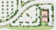
STARKEY RANCH BLUEBERRY FARM PRELIMINARY PLANNING
Framework Group (Client) requested us at Torti Gallas + Partner s to undertake the planning efforts on the Starkey Ranch at Trinity, FL to study various residential neigh borhood layouts for the site. The final plan required 15% of the total site acreage for stormwater managemen t ponds. while providing a 400–500-unit 3-4 level multifamily and single-family rental communities. The fina l plan includes pedestrian trails and streets network, zoning lots, SWM ponds, clubhouse locations, parking, etc. Yet, the plan stayed flexible with the approximate unit and parking tabulations.
CONCEPT E
MULTI-FAMILY CORRIDOR APARTMENTS with 1,100 sf average net rentable per unit.
MULTI-FAMILY WALK-UP APARTMENTS with 1,100 sf average net rentable per unit.
1-BR+DEN CARRIAGE HOUSE with 640 sf building footprint.
4-BR SINGLE FAMILY HOUSE WITH ATTACHED GARAGE average lot size is 3,940 sf, with 1,475 sf building footprint (excluding 310 sf attached garage).
3-BR SINGLE FAMILY HOUSE WITH ATTACHED GARAGE average lot size is 3,655 sf, with 1,295 sf building footprint (excluding 310 sf attached garage).
2-BR SINGLE FAMILY HOUSE WITH ATTACHED GARAGE average lot size is 3,300 sf, with 1,100 sf building footprint (excluding 310 sf attached garage).
4-BR SINGLE FAMILY HOUSE average lot size is 2,400 sf, with 1,080 sf building footprint.
3-BR SINGLE FAMILY HOUSE average lot size is 2,400 sf, with 1,080 sf building footprint.
2-BR SINGLE FAMILY HOUSE average lot size is 2,400 sf, with 1,080 sf building footprint.
FARM PRELIMINARY PLANNING
In this project, we provided a planning, design and entitlement services for the Oldsmar Flea Market Site in Oldsmar, Florida. The site development had a close attention to access roads which lead to Racetrack site, proximity to the traintracks at north end of the site, overhead powerlines at west. Amid all the urban chllanges, we were successful in proposing a mixed use plan with a live ur ban plaza at its core.
May 2019 - July 2021
PROJECT DESIGNER AND URBAN PLANNER
STERLING
PLACE - CONCEPT RENDERING
I joined the Streetsense on May 2019, a truly multi-disciplinar y design firm with multiple offices across the globe. Streetsensers work on varieties of creative project s from branding and marketing to space design. As an urban planner and project designer in our Bethesd a headquarter, I was mainly working on urban design projects, focusing on retail and mixed-use task s. Yet my involvement extended to other disciplines such as architecture, interior design, wayfinding an d some branding projects.
In my design development process, I have always produced variet ies of renderings and diagrams in order to communicate in the best and most efficient way, with the clients. For my 3D renderings and model makings, I usually use SketchUp as my base, and for renderings, I either u se VRay plugins or Enscape.
For the Knox Road project, I used the combination of Sketchup, Enscape, and Photoshop to provide several alternatives for storefront design challenges. The combination of these techniques, helped the Streetsense team to lead the clients towards the best approach in the desig n process of their new mixed-use project.
KNOX ROAD
KNOX ROAD STOREFRONT
This project was proposing repositioning strategies for Christown Spectrum and for Kimco Realty, to create truly forward looking, unique and identifiable spaces within the existing constructions. At Streetsense, we conducted a Retail Market Analysis and, based on our findings, we generated incremental repositioning strategy that seeks to create a short-term place-based retail environment while maintaining flexibility for long-term reorientation and/or redevelopment of the mall.
Our plans and renderings for different scenarios, responded to projected retail demand and recommended merchandising from the Retail Market Analysis, while achieving the client’s stated goal of reallocating the leasable area into two retail nodes that serve differing customer bases with additional on-site density from other (residential, office, and/ or hotel) uses. Further, our team translated this vision into a set of understandable exhibits and ideas that allow key stakeholders to visualize the project and understand the repositioning strategy moving forward.
As part of the project responce, I have been involved in develo ping several renderings for varieties of urban landscapes within the projects. Considering the climate conditi ons in Phoenix, AR, I developed several pocket parks to reflect each community requirements.
The Christown Spectrum’s Community Plaza has developed not only to serve the residents within the project by offering a small pedestal-stage, large shades and bistro chai rs and tables, but also to offer strong felexibility in programing so it could be used for other community pruposes such as serving surrounding retails and restaurants.
The Christown Spectrum’s Pocket Park has mainly developed to se rve the surrounding offices and big-box retails. By using the native plant species to provide shading a nd privacy, accommodating several built-in benches on the planters, and lowering the site’s ground base f or couple of steps, the pocket park offers a quiet and relaxing space.
In Founders Row project, our team at Streetsense was commisione d for an extra services after our branding services to provide parking wayfinding signage and graphics for this under construction mixed-use development, in Falls Church, Virginia.
The site is located on Broad Street (Route 7), at the western e dge of downtown Falls Church, where the Washington & Old Dominion Trail crosses Route 7. An interior ro ad bisects the site, connecting Broad Street to Park Avenue; the primary entrance to the structured parking is from this road. The site features ground floor retail along the street frontage and surrounding a central inte rior open space. The upper-level use is multifamily residential, with two Mill Creek brands featured on site : the Modera and the Verso.
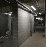
Our team studied and evaluated the as-built conditions of the s tructured parking, which includes two levels at grade and above and three-below grade levels. We then evaluated the wayfinding strategy through the garage for all uses and develop plans, elevations, and schedules for the implementation of signage and graphics by the painter and sign fabricator.
2
3
4
4
3
4
5
6
PLAZA - DAILY USES
The 29th Street development is located in a unique context betw een the Boulder Creek recreation corridor to the south and Pearl Street to the north which leads directly in to downtown Boulder. As the shopping center started to age, the client asked the team at the Streetsense to provide fresh design solutions to renovate the existing context and retail environment.
PLAZA - EVENT USES
After visiting the site and performing a diagnosis of the exist ing conditions, and evaluating a variety of opportunities to enhance the project, the following interventio ns were determined to have maximum impact to elevate the project’s retail presence and increase the ability to attract and retain customers.
CANYON + 29TH - LOOKING NORTHEAST
Canyon and 29th Street - Looking Northeast
OPEN VIEW INTO PLAZA FROM 29TH STREET
CANYON BOULEVARD - LOOKING EAST
During my professional working experiences as a planner and project designer, I have worked on several report development and conduction of design guidelines. Huntington Clu b Comprehensive Design Guideline was one of the projects that I developed by a team of planners for the Huntington Club project. The project provides suggestions that create a new node of activity adjacent to the Huntington Metro Station, at central Alexandria.
This design project provides low and high-density residential d wellings, retail offerings, offices, and a hotel. In addition, the neighborhood will include accessible outdoor s paces and amenities to support development. Huntington Club is structured into a series of land bays that a llow a variety of housing types, densities, and land uses to co-exist.
In order to ensure that there is coherence in the visual experience and through the implementation phase, this document presents general design guidelines with the intent of ensuring high-quality development, addressing site planning of the land bays and public realm, architectural design, and guidelines for the retail component of the project.
3.3 TOWNHOUSE GUIDELINES
3.3 TOWNHOUSE GUIDELINES
The 167 proposed townhouse units in Huntington Club are located to take advantage of the project site’s topography and to provide a transition from the mid and high rise building in the southern land bays to the low-density single-family
TOWNHOUSES
TOWNHOUSES
The 167 proposed townhouse units in Huntington Club are located to take advantage of the project site’s topography and to provide a transition from the mid and high rise building in the southern land bays to the low-density single-family
Eighty-one (81) townhouse units are proposed for Land Bay A. Each unit should generally have feature 2-4 stories and share sidewalls with neighboring units. The main pedestrian and vehicular entry to each unit will provide direct access to grade. Garage entries are strongly encouraged to be located at the rear of each unit, as they reduce front yard areas for landscaping and soil volume for tree growth. The height of each unit should not exceed 55’, as measured from the lowest grade to the building roof.
Eighty-one (81) townhouse units are proposed for Land Bay A. Each unit should generally have feature 2-4 stories and share sidewalls with neighboring units. The main pedestrian and vehicular entry to each unit will provide direct access to grade. Garage entries are strongly encouraged to be located at the rear of each unit, as they reduce front yard areas for landscaping and soil volume for tree growth. The height of each unit should not exceed 55’, as measured from the lowest grade to the building roof.
STACKED TOWNHOUSES
STACKED TOWNHOUSES
Eighty-six (86) stacked townhouse units are proposed for Land Bay C/D. A stacked townhouse is an individual townhouse unit that is placed vertically in a (2+2) configuration. These two stacked units should be treated as a single façade and as a single unified expression. Each unit should generally feature 1-2 stories and share sidewalls with neighboring units. The main pedestrian and vehicular entry will each unit should be located at grade, though access to the upper units should be provided via a stair and/or elevator. The height of each unit should not exceed 60’, as measured from the lowest grade to the building roof.
Eighty-six (86) stacked townhouse units are proposed for Land Bay C/D. A stacked townhouse is an individual townhouse unit that is placed vertically in a (2+2) configuration. These two stacked units should be treated as a single façade and as a single unified expression. Each unit should generally feature 1-2 stories and share sidewalls with neighboring units. The main pedestrian and vehicular entry will each unit should be located at grade, though access to the upper units should be provided via a stair and/or elevator. The height of each unit should not exceed 60’, as measured from the lowest grade to the building roof.
3.3.3 ARCHITECTURAL CHARACTER OF TOWNHOUSE LAND BAYS
The following exhibits provide guidelines for the general massing of townhouse land bays in Huntington Club. The massing of each development depicts one potential configuration and is provided for illustrative purposes only. The final program and layout may vary subject to County review and approval.
ATTACHED TOWNHOUSES
MATERIAL
This Land Bay is entirely woodframe construction. Land Bay A is comprised entirely of 81 attached townhouses constructed in stick of seven (7) to ten (10) units per row.
HEIGHT
Units are three stories tall, with two residential floors over a garage.
communities to the west and south of the project. Given the complex site conditions, townhouses in Huntington Club will be built ‘into’ the hillside, meaning that at-grade front entries and rear garages may be on different floors.
communities to the west and south of the project. Given the complex site conditions, townhouses in Huntington Club will be built ‘into’ the hillside, meaning that at-grade front entries and rear garages may be on different floors.
Two types of townhouse units are proposed for Huntington Club:
Two types of townhouse units are proposed for Huntington Club:
ARCHITECTURAL DESIGN GUIDELINES
The typical width of these units will allow for two-car tandem garages, accessed from a rear alley.
PARKING ROOFTOP
Roof access, including an enclosed partial third level, is planned for all townhouses.
TOPOGRAPHY SOLUTIONS
Site topography allows for an extra
F IGURE 23: LAND BAY A ARCHITECTURAL CHARACTER
ASG Architects
Jun 2017 - Apr 2019
URBAN DESIGNER AND PLANNER
In 2017, I joined ASG Architects, a more than a century old mul ti-disciplinary design firm. ASG is mostly focused on campus and higher education architecture with severa l offices across the US. Although I have been a member of planning studio in our Baltimore headquar ter, yet, my involvement extended to wide-range of disciplines such as landscape architecture, ar chitectural design, campus housing research, architectural photography and physical model making for international and national projects.
UNIVERSITY OF ILLINOIS AT CHICAGO MASTER PLAN
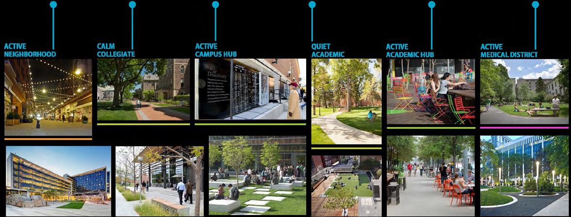
The “UIC Master Plan Update: 2018 Implementation Plan” was a co mpelling vision for changing and growing the physical infrastructure in a way that will enable the continued upward trajectory of UIC’s academic and health care programs. It is a multifaceted plan for implementing the S trategic Priorities that embraces change and was developed from the following guiding principles: [1] Drive Excellence: Build appropriate environments to support academic and healthcare programs; [2] Enhance Identity : Create a welcoming setting that encourages people to linger; [3] • Our Campus is Chicago: Connect people a nd the campus to the city; and [4] Transform UIC: Leverage campus heritage and change the physical paradigm to appeal to all.
More information can be found here: https://cppm.uic.edu/masterplan .
CONCEPT PLAN: EAST CAMPUS EXPERIENCE
A major focus of early concept planning was the notion to create a defining primary campus experience for East and West Campus that would help unify UIC as a whole, elevate the quality and sense of place, and enhance key portals. This manifested itself on the East Campus as an enhanced northsouth promenade connecting the UIC-Halsted Street CTA station at the Peoria Street bridge through the Central Quad to University Village. All the various functions and amenities of a thriving and bustling urban academic campus should be experienced along this spine.
CONCEPT PLAN: WEST CAMPUS EXPERIENCE
On the West Campus, the concept takes the form of an enhanced east-west thoroughfare that connects Arthington Mall Plaza to the Ashland and Taylor Gateway. All the functions and amenities of an active, urban, health sciences and medical campus should be experienced along this new primary campus connection. The pedestrian promenade connects to mass transit at the CTA’s Polk station.
University
Sep 2011 - May 2014
GRADUATE STUDENT OF LANDSCAPE ARCHITECTURE
After more than seven years studying architecture and architect ural history, I could clearly conclude that my true passion is studying cities, their unique cultures, and coming up with sustainable solutions for urban living. In UIUC I trained myself to explore how cities an d their neighborhoods interact with their residents and how each of them influences one another. Since the n, I am seeking to reflect my ongoing researches in my designs which are not only building masses, bu t also the spaces between them.
WAVES OF DOMINATION
This project was a part of a semester-long teamwork project of urban design workshop, aiming landscape, planning and design proposals for conserving Orchha’s natural, cultural and archaeological heritages. Orchha is located in Madhya Pradesh, India with an important cultural and landscape heritage since it served as the capital of the Bundelas from 1531-1783 CE, Orchha’s heritag e is under threat from new development, degradation of historic sites, and loss of collective memory. T his design workshop tried to propose solutions for urban management, urban planning, and urban preservation.
Traffic of Orchha town is spread across a vast landscape, however , it is concentrated on the western side of the Historic Fort. Thus, the traffic management proposal focused on fi ve different flows of animals, pedestrians, light, moderate and heavy traffics. Since all these flows have acc ess to all of the town’s pathways, this has caused traffic congestion problems. The traffic management proposal suggests four pedestrian-only zones for the main intersections of the town, Moreover, based on the five traffic typologies, different roads and pathways are proposed.
In Orchha, the lack of urban infrastructures, facilities, and f urniture is visibly present and also the existing infrastructure is not managed and developed properly. Thus this traffic management proposal addressed these issues as well. Some of the existing facilities are propo sed to be further developed and expanded, while a proper site was proposed for others. This design also focused on one of the historic gardens of the town and proposed its preservation and development as a tourist destination.
Proposed Facilities and Pedestrian-Only Zones
Proposed and Existed Bridge
Proposed City Hall and Community Center
Proposed First Aid and Emergency Station
Proposed Fire Station
Proposed Hospital, Clinic and Drugstore
Proposed Parking Lot
Existing & Developed Police Station
Existing & Developed School
Proposed Transit Station
Existing Moderate Traffic
Proposed Moderate Traffic
Existing Heavy Traffic
Proposed Heavy Traffic
PHOTOGRAPHY
Photography has been my favorite extracurricular activity since high school. I further developed my skills when I was hired at PoyaZ ist Co., Tehran as an intern in 2003, when my main initial responsibilit y was to be an architectural photographer. I have held two architectural ph otography exhibitions of my work at the Iran University of Science and Te chnology. Some of my works have been awarded in competitions, and some ha ve been featured with AIA or other institutes’ winning projects.
Taking photos helped me gain a better perspective of my environ ment and understand the details of human behavior and their involvem ents with different spaces.
Drowning boats of colors. Seattle, WA
The Gap. Honored as Spotlight by Aminus3 Group. Parc André Citr oen, Paris, France.
Self Photo-Manipulation
OTHER DRAWINGS, PERFORMANCES AND EXHIBITIONS
Freehand drawings were my first experiences in architectural pra ctice. Later, I have gained experience in digital photo-montage, 3D rendering and etc which led me to explore my other talents in dance and modeling; all in which, increased my ability in graphical thinking.
With a very strong interest in different arts, I have had differe nt dance and music performances. As a vocalist, I have been performing since 2001. As a choreographer, I have per formed in both UVA and UIUC.
Teamwork Wall Paintings and Art Installation At IUST campus
Open-Air photo exhibition of my works at IUST campus
Drawing Advertisement for Photo Exhibition of IUST campus
Poster for “Student Art Exhibition”, IUST, 2007. A2 Size
Dance Performance, UVA, 2011
Balcanalia Concert, UIUC, 2013
Photo Modeling, Urbana, IL, 2014
Proposal for Clinical Center, Bistre Technique, IUST
Arg Bam, Oldest mud brick town in the world. Bam, Iran. Septemb er 7th 2003; one week before earthquake. A3 size
Designed Website for Living Place Competition
DIGITAL ART
I extend my creative expression into the digital realm, explori ng a range of techniques from photo manipulation and digital graphic making to AI-assisted surreal painting. Most of my digital artworks, like my traditional pieces, communicate the experiences and emotions wi thin my personal sphere to the broader world. Using advanced digital tools, I craft visually captivati ng pieces that blend reality with the surreal, creating a unique narrative style.
In my digital art, I employ various methods to enhance and tran sform photographs, create intricate graphics, and generate surreal paintings with the assistance of AI. This diverse approach allows me to vividly convey themes of mental health struggles, immigration, social injustic e, and political activism. My digital creations serve as a continuation of my traditional works, maintaining a consistent theme of a woman of fire and her unending battle to survive and thrive. Through this digital med ium, I aim to foster a connection with viewers, providing a sense of validation and expression that transcends the boundaries of traditional art forms.
PAINTING
As an Iranian-American designer and artist, I use my art to com municate the events and emotions within my personal sphere to the broader world. My artworks narrate the s tories of a Middle Eastern immigrant woman residing in the US, striving to stay resilient amidst life’s ch allenges. My creative journey has led me to explore various mediums and techniques, from color pencils, pastels, an d ink to watercolor and acrylic. Reflecting on decades of my creations, a consistent theme emerges: a woman of fire, and her enduring battle to survive mental health struggles, immigration experiences, social injustices, and political activism.
I see my art as a powerful healing tool. An epiphany for me was realizing that the healing effects of my art extend beyond myself as the creator. Many who have seen and connected with my artworks have felt seen, validated, and expressed through visual mediums that transcend the limitations of words. This profound connection with viewers is one of the most fulfilling a spects of my art, reinforcing my belief in the transformative power of creative expression.
“Flames Behind the Christmas Eve”, 12”x12”, Acrylic and metalli c pen on black canvas, Completed
“My Dreams for the Poor Unfortunate Soul”, 18”x24”, Acrylic on canvas, Completed 02/27/2024
“Resurrection, in days of pain and hope”, 11”x14”, Watercolor o n canvas, Completed 02/12/2023
“Built on the Wind Panel” (two panels), 9”x12”, Watercolor on p aper, Completed 01/13/2022
“That Goddess of Turmoil”, 20”x10”, Acrylic on canvas, Complete d 07/04/2022 Presented artwork at the Exhibizone Virtual Exhibition “Woman”, March-April 2023