2 minute read
GREEN INFRASTRUCTURE FOR SRORMWATER MANAGEMENT
Frequent and severe flooding disaster has plagued Jakarta, Indonesia, for years. This site which called Kampung Keduang Kali Angke is a dense community of West Jakarta, the condition of a large number of impervious hardscape area resulted in that the infiltration rate is low, shabby unsound drainage system fail to discharge stormwater timely, these problems have made it had frequent flooding in the site.
This project design is divided into three main strategies of green infrastructure management to delay and reduce the peak runoff to alleviate even solve flooding problems in the site.
Advertisement
The first strategy is to redesign the drainage system and waterflow direction to collect and convey stormwater and discharge it to two main canals in the site, deducing the concentrated catchment area as the proposal water storage spaces. Than connect the existing drainage facilities along the streets with the water storage spaces to complete overall drainage system including primary drainage network, secondary drainage network, tertiary drainage network and new confluence point. The aim is to slow down the speed of waterflow discharged into the canals in the site.
The second strategy is to design rainwater harvesting facilities, with rainwater collecting barrels to collect rainwater from rooftop and building surface, and use the rainwater filter barrels to filter it for water reuse, such as daily housing use and garden irrigation. And the rainwater harvesting facilities will be placed around the buildings within the radius of the catchment area.
Lastely, the third strategy is to improve the water storage capacity by selecting the concentrated catchment area in the site according to the catchment analysis. Six different nodes will be designed as the potential water storage spaces that contain detailed bio-retention and detention facilities, such as community rain gardens and ecological detention ponds. The average area of these nodes is 466m2. The goal is to improve the storage capacity of the whole site through these shared pocket spaces. It also can be a pleasant feature that makes space for nature in an urban environment.
Through these kinds of measurements, the aim is to create a proper site with thorough waterflow system and strong water capacity, so that it can make the site be flood-resistent, minimize the potential environmental impacts on stormwater runoff and provides a safe, resilient and comfortable living environment for local Kampung residents to promote social interaction among community members.
Province
City
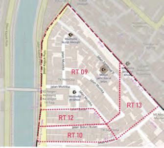
District Kampung RW RT
Division of region under village. One RW consists of several RT.


Division of region under RT. One RT consists of several households.

Background
Major Floods Events in Jakarta's History
Flood in 1996
Cause: The capacity of river is smaller than the incoming water's runoff, caused by the high conversion of area around the waterbodies into settlement function, sedimentation, and illegal waste disposal
Inundation Area: n/a
Inundation Point: 90
Rainfall Intensity: 288.7 mm
Evacuee: 544,000
2002 2007 2013 2020
Cause: Vast buildings and settlements has led to the decresing of land absorption ability as well as narrowing the canal in downstream area.
Inundation Area: 330km2
Inundation Point: 160
Rainfall Intensity: 361.7mm
Evacuee: 380,000
Cause: Beside the poor drainage system, flood was preceded by heavy rain.

Inundation Area: 400km2
Inundation Point: 70
Rainfall Intensity: 401.5mm
Evacuee: 398,000
Cause: Because of the heavy rain and waterways clogged with garbage and other kinds of debris
Inundation Area: >400km2
Inundation Point: 109
Rainfall Intensity: 1230.7mm
Evacuee: >100,000
Cause: Climate change
Rainfall Intensity: 400mm2
Evacuee: 36,000
Average Rainfall Intensity during Major Floods
Souece: <The ecolution of risk and vulnerability in Greater Jakarta: contesting government policy in dealing with a megacity's exposure to flooding> by Jonatan A. Lassa, Saut Sagala AHK, BMKG <Study on the risk and impacts of land subsidence in Jakarta> by Irwan Gumilar
ISSUE BEING TACKLED Interview With Local Residents
"The height of flood can be 0.4m in our house."
"We go upstairs when it is flooding."
GARBAGE FLOATING ON THE CANAL
"The canal has been widen several times from 2m to 9m."

"We throw waste directly, no recycled garbage bins here."
FREQUENT FLOODING
Sometimes the sewer has been stuck with the garbage.


