3 minute read
ISSUE BACKGROUND
35-40% of channel capacity is lost due to sediment deposition upstrem soilerosionfarmingactivitiesdownstrem
6500-7000 t of garbage are produced in the river every day, the main source of which is household garbage
Advertisement
30-70 cm of water depth on municipal roads during flood season
12 centimetres of land is sinking every year in Jakarta, especially in northern parts of the city
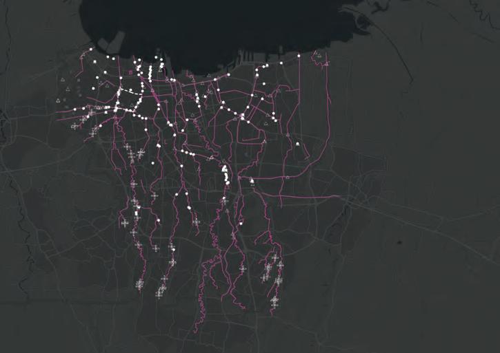
River Problem Location
More than 60 percent of Jakarta's residents depend on groundwater.This provides nearly two-thirds of the city’s water consumption, around 630 million cubic metres out of 1 billion m3/year.
shallowgroundwater source:http://theconversation.com/why-the-rich-in-jakarta-have-better-access-to-water-than-the-poor-its-not-the-piped-network-91658 https://www.bbc.com/news/world-asia-49481090
NATURAL REVETMENT (DAMAGED): Revetments,lackingprotectionfromnaturalvegetation,arevulnerabletofloodingandareamajor sourceofsedimentindownstreamwaterways
FARMING SPACE: Thelackofvegetationsurroundingthenaturaland unreinforcedchannel,adjacenttotheurbanfarmland system,isoneofthereasonswhythechannelcarriesa lotofsedimentduringtherainyseason
GARBAGE: Theubiquitousgarbageiscarrieddownstreambythe river,causingseriouschannelcongestion.During periodsofcontinuousrainfall,evenseverefloodingcan occur
WATER POLLUTION: Uncontrolleddischargeofdomesticsewageand industrialwastewaterleadstoeutrophicationofwater bodyandseriousbedhardening.Atpresent,theriver carryingcapacityisfarlowerthanthedesignedlevel unhealthyriverbed nowcontains20,000tsilt lost35%-40%designcapacity


5.5m
Waterleveldifference contains114,000m3water
48mm
30% +114,000m3
Riversedimentation ±0.5M 2.1km2 contains2,000,000m3water 600,000m3water714,000m3water needbeconsidered Catchmentarea
Datasource:https://zh.weatherspark.com/
Current River Section Current River Section
Water Model Simulation

Velocity.(simulation time:362s)


Shear Stress Excess.(simulation time:362s)


Velocity.(simulation time:177s)
Shear Stress Excess.(simulation time:177s)


Water Model Simulation
General river section
General river section- (wetland part)


Construction Planning

Site construction sequence
forth stage(2year later) third stage(1.5year later) third stage(1.5year later) first stage first stage: transfer the sediment nearby
Node perspective(sediment pool) second stage(1 year later) first stage sedimentpool sediment

Masterplan of Jakarta Cengkareng Drain Park (Flooding season)


a-a’section freshwatercreek b-b’section sedimentpool
Reinforcedriverbase
Open freshwatercreek


ZHANG Bingqian
The site is located in the northwest of Jakarta, adjacent to Kali Canal. It is a kampung with a history of more than 60 years.
The study found that the Kali River has been widened in 2015, resulting in the forced demolition of more than 300 families in the surrounding area and moved to the new residential community along Daan Mogot Street, nearly 7km away. Since many residents were unwilling to be demolished and did not want to move to new tall buildings, this issue intensified the conflict between the government and residents, leaving the remaining people still living by the Kali River without a sense of belonging. At the same time, in Jakarta’s 2030 plan, the road along the Kali River will be rebuilt and widened to become a secondary road, which means their home will face demolition as well. Therefore, it is inevitable for them to leave, and, Jakarta ’s violent resistance to relocation shows that new living conditions must be carefully considered. This project aims to provide a new living environment that can provide them with the sense of belonging. The new residence will enable them to adapt to the high-rise building and participate in social production, resulting them treating it as home rather than a temporary residence. Through field investigation, it is found that in kampung, people manage themselves through the RT and RW system, which is one of the reasons why they do not want to move. Secondly, their income comes from each other, only a few people are factory workers, more than 40% of the households are engaged in informal sales activities like street vendors. In addition, it has many outdoor activities. And Kali River as their public area has become part of their daily lives. This design will reconsider people ’s resettlement issues, making the site close to the river, and create different landscapes by introducing water from the river into residential and agricultural area. For better agricultural production, it is determined the most suitable cultivated land through sunshine analysis. And rivers introduced will provide the irrigation. In terms of living environment, the river will flow along each building to give people the familiar feeling of still living on the banks of the river. After satisfying self-sufficiency, they can obtain the sense of ownership and belonging again. At the same time, using farming activities as a catalyst can enhance sense of community, financial support, education, and branding.
LANDUSE MAP Location of the Kedaung Kali Angke
The site is located in the northwest of Jakarta, adjacent to Kali Canal. It is a kampung with a history of more than 60 years.
Landuse of the Kedaung Kali Angke
The kampung village consists of the school, shops, family industries, kindergarten, and the mosque.


Riparian Space Activities
Kali River bank is the main open space
Kali River is not only the landscape unit, but also the open space for residents. People gather along the river to interact with each other.

Riparian Space Activities


Kali River bank is the main open space


Activities In Kampung


Hawker’s route connects the important places.


play community
Issues In Relocation


From Kampung places to Highrise building


Compared with the rich activities in the kampung, the new settlement will meet the needs of people to communicate, and also affects the income of the shop.

Apply Kampung Needs To Resettlement
Combine the needs of kampung with the space in new residential area
This design combines the characteristics and activities of the kampung with a new way of living to provide suitable sites for future development of residents, hoping to provide a more suitable environment.
Demands of Kampung Residents
Production methods


Organize


Design Ideas

Agricultural and Residential Integration System


Using the farming production not only produce the vegetable and fruits, but also the increase of waste and pollution.
Section Of Design
Shade arrangement

SUNSHINE


MASTER PLAN along Kali River


Body Text - 8pt font size, 11pt leading space (Sentence Case)

The ne site will be along the Kali river and equiped with the basic needs of the residents.


Aerial View
show three-dimensional structure of the site


From the aerial view, the layout helps to make the maximum of the sunshine area for planting. Besides, it produce the shade, partial shade and patial sunshine area.

Aerial view direction view also from the Kali river


