18 minute read
Hike & Fly; Guideless Buttress and Mt Potts
by NZ HGPA
Climb and Fly Lorraine Johns on two recent climb and fly adventures
Mount Wakefield, Aoraki/Mount Cook National Park
Advertisement
ugh, I’m splinched. I’m trying to force my way up a narrow rock chimney, but the bulky paragliding pack on my back keeps getting stuck. Elliott is ready to climb down to help, but I need to sort this myself. Elliott, the stronger climber, has breezed up the exposed arete next to me. The chimney has a good run out; the arete does not. However, I just can’t fit into the same spaces that I normally would with a slick climbing set up. I eye up the slab – miniscule holds, but aesthetically pleasing. I don my rock shoes and step up onto the airy traverse, the friction of my soles keeps me safe as I continue upward.
It’s the penultimate day of April, so we are climbing at the cusp of the seasons. Thermals are long gone, and this will be the last opportunity to climb this route, an imminent front set to bring snow. We’re ascending the Guideless Buttress on Mount Wakefield in Aoraki Mount Cook National Park, an 800-metre-high route that goes directly up from the viewing platform at the Hooker Lake to the summit massif.
If you don’t know about Mount Wakefield, well you should. The peak is, apparently, one of the 19 holy mountains of the world and was “charged” with “majestic spiritual powers which can never be depleted” on Christmas Day in 1960. There is a ‘famed’ holy rock on the mountain, inscribed with the word “charged”. Rumour has it that the graffiti artist was gunning for Aoraki Mount Cook but had to settle for Wakefield when he discovered there was no walking track linking the two. In fact, I’m not sure he actually liked Wakefield that much, as the holy rock lies in the vicinity of Point 1566 on the South Ridge, quite a long way from the summit.
Today Elliott is feeling charged. Me, I’m a bit ancient and sleepy, but delighted to be here. Neither of us have climbed this route before, but I’ve climbed the nearby Routeless Buttress. I hadn’t been certain on that occasion if I could safely climb a technical route like that by myself with my wing, so the only added flavour then was in making it a day trip from Christchurch. However, a year later, I know enough to pitch this objective to Elliott as safely manageable with wings and without a rope.
We’ve been up since dawn, leaving at around 7am. Elliott was keen for an earlier start, but I had tempered enthusiasm for route finding without a moon, particularly as there was a risk of frost. In daylight, everything so far is going like clockwork. We had started up from the lake by following a dry stream bed at the base of the buttress, avoiding the most difficult climbing, and gaining the ridge proper just as the sides began to fall away.
Now here we are climbing in the cool autumn sun, icebergs glinting in the Hooker Lake just below us, the highest peaks in the country just around us. As we wind our way up, the ground is changing from crumbling greywacke to the comforting redness of ironoxidative weathering. I tell myself I’m completely focused on the climb, but I can’t help but notice what the wind is doing. There is almost no wind so far, though at times we feel the odd weak thermal. I know the launch at the top has the potential to be very challenging, but we are in a marvellous place and I’m in the moment.
Elliott is spending most of his time heading directly up the beautiful but exposed ridge crest. Me? I often pop off to one side or the other, to take an easier line. At one point I even
call up – did you see this tramping sidle? He sure did, but he is just loving that rock. If we were recording GPS tracks, they would look quite funny - Elliott’s beeline, and my frequent little zig zags. Around lunchtime the rock becomes blocky and crumbly, signalling that we are approaching the top. It’s at this point things become a bit less straightforward.
At the edge of the undulating
12 A irborn
plateau we’ve reached, there are no safe launches. The ground is undeniably rocky, and the wind always seems to reach us in the lee of some or another tiny outcrop. It’s also coming from the north, when the only good launches here are to the south. It’s not going to be easy to launch today unless we drop down snow to the southern tarns. We maintain our height and head north to scope out the scree slope between Point 2012 and the summit. The wind here is disappointingly light and swirly, and it doesn’t feel safe. We head back up to a col just west of Point 2012 – it’s now our only option now unless we drop to the tarns. Time is ticking.
Since we last stood on this spot, the wind has picked up from 15km/ hour to over 20 km/hour, sometimes
gusting 30km/hour. Elliott is a much more confident strong wind pilot than me and I’m nervous, so we decide I’ll go first. I agree with Elliott’s assessment that we’re in a venturi. If we can launch in a lull, it will be safe. Wind at launch is the part of flight I feel most connected to, and I have frequently found wind to sharply decrease just below a high point.
Here, I don’t want to drop any height because I’m on a small wing with a poor glide and the ground below us is shallow, some large rocks threatening the exit. Elliott reassuringly tells me to take my time. I’ve said this to others before and it’s what I need to hear myself right now. However, I immediately make a mess of my beautifully preclipped wing when a line catches during inflation. After I collapse my wing, the wind becomes so strong that all I want to do is bunch up and crouch on my wing. I needn’t have worried. Every single line seems to have become stuck, and now it feels like I couldn’t get the wing off the ground if I wanted to. Which of course I do.
We decide to drop down ten metres where the wind is oscillating from nothing to about 15 km/hour. Now we must time launch to make sure it’s as strong as possible. Elliot has unclipped to help me as, every time I try to launch, something catches. I pull my wing into a wall when it starts gusting and he quickly dives around unhooking every caught line. Finally, it’s up above my head. I run as hard as I can. It’s an intimidating take off and the wind pushes me toward two large rocks just after my feet leave the ground. I steer between them, lifting my legs. The ground immediately drops away and suddenly I’m flying in Mount Cook National Park for the first time.
The view is unbelievable. I fly away from the terrain because I’m moving fast enough to suggest there is a bit of power in the air. I fly out over the Hooker Lake and look to Aoraki and the upper Hooker Glacier, rimmed by the dramatic peaks. I’ve spent an embarrassingly long-time telling Mt Cook Traffic that I’m about to launch, so it’s a relief to finally report an aerial position. I love losing my height over the flats of Mount Cook Village – what a place to do circles in the air. It’s nonetheless a relief, when I land, to not still be standing at 2000 metres, but where’s Elliott? He responds once to my radio calls then I don’t hear from him again. I hope it’s just that the radio has stopped working but can’t help starting to worry.
Meanwhile, Elliott’s radio has disconnected, and he hasn’t been able to get away. Every time he tries, something catches. With no-one to clear lines for him, he heads back up to the top launch. It’s still strong and he knows that when he pulls the wing up, he’ll be stationary – so he needs to find a lull and patiently hang suspended while slowly creeping forward. When I finally see him in the air, words cannot describe my elation.
Back at the lodge I collapse in a heap as we sit and laugh and try to unwind. Launching has been an intense emotional effort, completely dwarfing the climb and the flight itself. It’s now late afternoon and what we really need is to make an early dinner and head to bed. However, some lady with too much pre-trip enthusiasm had come up with a ridiculous plan to climb The Thumbs the next day. So that’s what we’re off to do now. We’re fully committed as we’re meeting a friend in Tekapo to walk the first couple of hours up the Macaulay River. The forecast has deteriorated, and summit day is no longer looking great, but we nonetheless find ourselves at Lilybank Station at 9pm that night, about to embark on another adventure.
Just like for the Guideless Buttress, I’ve been in the area before, done the maths and give us an 80% chance of success. Provided we can get to the twin summits in daylight, then we’ll have no choice but to suffer the sodden trudge back to our low camp. And somehow, just somehow, we pull it off, climbing both the High and Low Thumbs the day after our climb and fly of Mount Wakefield. The weather holds as we walk up the glorious, golden, sun-drenched valley in a gentle but steadily increasing breeze. A nice day to be climbing. Yet on the summit of the High Thumb I still look across to Elliott and wonder if he is thinking the same thing as me – is this launchable right now?
Left; Elliott landing near Mt Cook Village
Photo; Lorraine Johns Right; Flying over Wakefield
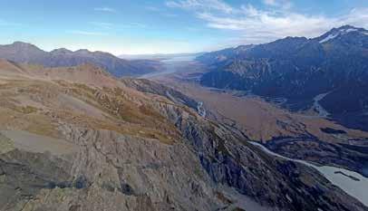
Below; view of the Hooker from Wakefield
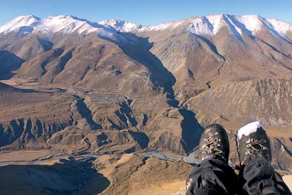
Photos; Elliott O’Brien Above; Elliot with flying kit on board
Right; With Mt cook in background
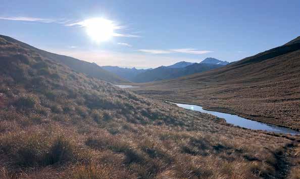
Below; Looking toward the launch site
Photos; Lorraine Johns


i’m pretty obsessed with Erewhon. It’s a place which inspired Samuel Butler’s 1872 satiric fantasy story, following his exploration of the headwaters of the Rangitata river. Erewhon is an anagram of “nowhere” and that’s exactly what it feels like here, at the gateway to the Garden of Eden. Today I’m right at the start of nowhere – Mount Potts.
By following a dry stream bed, created by very recent floods, I manage to avoid the masses of matagouri that threaten the lower flanks of the peak. I’ve decided not to go up the skifield road due to the amount of snow lying around. It’s bitingly cold on the nicely gravelled ridge when I reach it, even walking in my down jacket.
As I get higher, I’m surprised by the unexpected beauty of this place. There is a hidden valley between Mount Potts and an outlying peak called The Pyramid, and the sweeping change in colour as elevation increases, is dramatic.
Now I’m higher, the Italian I’ve been learning on the way goes away. The snow conditions are tricky, with avalanche danger on one side of the ridge, and an annoying layer of soft snow over iced up rocks on the side I’m on. Upward progress becomes slow even though I’m using an axe. To my amusement there is still the odd pole as I ascend – dilapidated remnants from the historic skifield below.
After wading through some hideous knee-deep snow, I make the summit to find no wind at all. I give myself a few minutes, then I get going. There was a small launch site just before the summit, but with no upslope breeze it’s too difficult for me and the next stage of my adventure requires a northern launch anyway.
I’m not committed to launching but if I have to walk down, I won’t go back the way I came, nor will I risk potential avalanche danger on the slopes leading to the skifield. I decide to drop to the northernfacing saddle between the summit and Point 2146. I can see a rocky slope below the small saddle and I’m hoping that might trigger an upslope breeze.
The saddle looks more promising from a distance than what eventuates when I reach it. There is a very slight tail wind but launching on the southern side of the saddle is nonetheless out of the question. It is icy, rocky, shallow, and there is still no upslope breeze when I stand on the edge. I commit to waiting for some wind to come up the sunnier, northern side of the saddle.
I have my small wing with me – a blessing and a curse. I could not launch my big wing here in nil wind, but I’m also not convinced I want to launch my small wing. The wing will pop up above my head from a small footprint, but it requires a runway. Even in a decent breeze a couple of weeks ago on Steepface Hill, I still ran a long way to launch. Here, there is no runway and no wind. Two steps are all I have to get my wing above my head and veer off the edge. I try a couple of times and my wing is like a jellyfish in the air.
I don’t have to launch. I won’t launch unless there is more wind. So I wait about 30 minutes, then to my delight, 3 to 4 kilometres of wind pops up the slope. Somehow my skinny riser catches on my chest strap and I immediately abort. Five minutes later there is another similar gust – I’m gone in a second. The wing takes enough of my weight in those two steps for me to commit and push forward with all my strength. I launch before my wing flies me away, as the ground is so steep it just disappears. However, my wing doesn’t seem to surge and suddenly I’m flying through smooth, velvety air.
I’ve launched later than desired and it’s June, so the daylight is short. Shall I fly back to the car? Nah. I’d rather bag Potts Hut. So I fly on to the north. The terrain is pretty, but not spectacular – that is until I fly out past the flanks of Mount Potts. What a valley lies beneath, glistening in the low winter sunlight. It’s so beautiful I’m momentarily sad that there is no one here to share this joy. As I fly into the valley, it just gets better. The most glorious tarn appears on the Dog Range opposite me. It literally takes my breath away. Suddenly I’m not sure if I will land at the hut. I really want to fly over the tarn. Indecision takes me, but at the last minute I decide to skim the tarn. This will also give me the best chance of a second flight back to the car.
It’s all very idyllic and lovely in this secret spot, until I reach the ridge crest, where there is a slight tail wind. I can’t launch. There is a multi-directional light wind launch on point 1485, but I don’t know if I can get there before nightfall.
When I try to launch from the edge of the shallow Point 1546, my wing is, once again, a jellyfish. It’s also almost impossible to get it off the ground to even try and launch, as everything is frozen solid. Even the dirt catches and firmly traps my lines. I pack my wing away when Evening Civil Twilight ends and blast my way down over untracked ground to reach the polled track below. From there it’s a cold walk back to my car and a warm drive back to Christchurch spent planning an adventurous return.

View flying Mt Potts Photo; Lorraine Johns

Mt Potts Landing
Photos; Lorraine Johns

HG HArnEssEs HELmEts

WOOdy VALLEy models for racing, training tandem and recreational. tenax 4 with tilt control options and removable skin. The ultimate race harness. Flex2 has Tenax construction with independent back supports that is lighter, more flexible, has easier landings and a more convenient packed size. Libero is super light and compact, a practical all purpose harness that provides support but goes upright well too, Replacable skin. Woody Valley have the compact Quadro square emergency parachute. Wills Wing have the all purpose Z5 harness with storage and front reserve options, as well as the modern Flylite 3 cocoon. The Aerodesign apron harness is the perfect first and dune flying harness with storage & easy launch and landing. INsIdER & NO LImIt by Aerodynamic helmets with 96% field of vision & strong, light kevlar/aramid re-enforced shell weighing just 650gms to save your neck muscles. Shock absorbing EPS liner for max brain protection. Breathable inner fabric. Scratch resistant colours including metallics, matt & carbon. Sizes 53 - 62 cm head circumference. EN966 certified for hg & pg. No Limit has faired back and optional polycarbonate visor for wind protection & aerodynamics, gives 100% UV protection & is anti-reflective, anti-fog & antiscratch. http://finsterwalder-charly.de/en.html Range of colours and sizes in stock
EmERGENCy PARACHUtEs IN STOCK NOW

over 30,000 rescue systems sold world-wide • Fast, reliable, opening. • Reduced weight & pack size due to high strength material and Dyneema lines. The reduced size and weight is especially useful for tandems and for hang gliders. • Optional steering for PG; Land where you choose. • Extremely low sink rate due to horizontal travel of the cruciform canopy. • sizes; 100, 125 & 160kg. Tandems 160 & 220kg. • Pendulum-free smooth descent. • 12 month packing cycle due to pack system design and construction. • Inner container stowed lines makes deployment easier & minimises tangling risk. Check out videos at; http://finsterwalder-charly. de/en/rescue-systems.html many accidents happen close to the ground, so a quick, reliable opening is most important. Many NZ pilots have been saved by their reserves; even with deployments below 50ft!! Paraglider models fit built in harness containers or front mount cockpit containers.
dIAmONd cross HANG GLIdER mOdELs have a UV and abrasion protected bridle. Optional swivel. Up to half the packed size and weight of conventional HG reserves. 125, 160 and 220kg sizes. tested to DHV certification. Fly with confidence knowing you have the best back-up available. WheN you really NeeD a paraChute, you oNly WaNt the beSt


NEW MODEL Just in
OUdIE N; GPS/alti/vario/nav. Sunlight readable high res colour touchscreen. World maps, airspace & terrain installed & updated, thermal assistant, task & triangle optimiser, wind, glide, terrain, IGC tracklogs, txt (sim or phone), scan QR turnpoints, web browser, wifi, forecast wind, wave, convergence (SeeYou & Skysight req.), customisable display, long life battery with phone charger. Fanet+ & Flarm option. OUdIE BLAdE Similar to above built into a slim instrument pod for HG. Airspeed pitot built in. Fanet+ & Flarm. Mounts for aerofoil basebars or uprights.
Crystal clear and sunlight readable display Exceptional battery life even at full brightness Easy to use SeeYou Navigator software Wifi, Bluetooth and 4G/LTE connectivity Free 1-year SeeYou subscription for seamless integration
www.naviter.com
HyPER; pocket size with colour maps. Ideal for daily flying and hike-and-fly. Navigate routes, complex airspace and record all details of your flight. Pocket size (107 x 70 x 18mm), Lightweight (135gm), Sunlightreadable colour LCD touch display, Wifi & Bluetooth connectivity, Maps and Airspace included. Element tRACK has 3D GPS track recording, USB downloads. Wind, All you need for everyday flying, comps & XC. Element sPEEd has GPS wind direction & speed for soaring & XC. Easy to operate, affordable & practical. Element ALtO; Robust, reliable & simple alti/vario with GPS alti, 250 hour battery life. Switch on & fly!
Choose the right instrument at; www.naviter.com/ free-flight-comparison-table/
HAnG GLidErs
skyfloaters are light and responsive to control with the best control authority and landing ability. From the best training glider ever built; the Wills Wing Alpha, to the World single surface distance record holder Falcon 4. Airborne’s best selling Fun2 and Tandem gliders. www.willswing. com www.airborne.com.au sport Class double surface gliders like the Wills Wing Sport 3 and Airborne Sting 3 have many performance options. More performance Wills Wing U2 hold their own at competitions and XC. Finsterwalder Funfex is super-light and packs without tools to just 2m. www.willswing.com www. airborne.com.au www.finsterwalder-charly.de/en/hanggliders-a-accessories/funfex.html Competition kingpostless gliders such as the Wills Wing T3 is a world leader & the T2C holds the world XC distance record. Recent performance and handling improvements. www.willswing.com Rigid wing Air Atos is the world leader in performance holding multiple world champs wins in Class 2. www.a-i-r.de/index.php Above gliders USHGMA or DHV Certified. Hang glider Repairs, spares, Full inspections and maintenance checks. NZ’s largest stock of parts for Wills Wing, Airborne Windsports, Finsterwalder and Enterprise Wings. Wires and tubes made to specifications. Round, aerofoil & rubber backed uprights, Quick-pins, etc. XC tRAINER
Vario/alti/flight computer, 16 ch GPS, wind speed & direction, speed to fly, thermal mapping, Google Earth output. Accurate & reliable. www.aircotec.com/
Wind mEtErs
Read the true wind speed so you can tell how strong or gusty it really is, indicating turbulence or whether it is safe or soarable. Essential for safe flying. HALL compact (11.5cm) ‘Small Hall’ is the best priced airspeed meter available. Simple and accurate. Brackets for hang or para. Never needs batteries!
Full baCkup ServiCe Glider & harness repairs, strip checks & trim/tuning. Student pilot instruction. Most items are in stock for overnight courier delivery NZ wide. Call or email for more information. Dealer, School and group order enquiries welcome
Over 25 years of free flying experience and quality service
QUICK OUt carabiner 4000 kp break load, Can released under load. With safety lock. Valuable for windy landings.


