
8 minute read
Developing Guidance for the Cadastral Survey Rules 2021


Géneviève Abrey, Licensed Cadastral Surveyor & Senior Survey Advisor, Office of the Surveyor-General – Toitū Te Whenua Land Information New Zealand
Advertisement
The Cadastral Survey Rules 2021 (CSR 2021) came into force in August 2021 and, since February 2022, new cadastral survey datasets (CSDs) can only be lodged under them. These new rules replaced the Rules for Cadastral Survey 2010 (RCS 2010). The Surveyor-General, Anselm Haanen, has the authority and duty to set standards for the conduct of cadastral surveys under Section 7(1) of the Cadastral Survey Act 2002.
The review of the RCS 2010 was started by then Surveyor-General, Mark Dyer. The purpose of the review was to ensure that the rules were able to be practically applied and were “fit-for-purpose.” 1 The first consultation phase of three kicked off in August 2017 with an “Issues and Opportunities” paper open for comment. We had 30 responses spanning several different areas of interest. In a high-level breakdown of the feedback, we found that 7% of the feedback on issues related to the guidance on the rules 2 .
The “Interpretation guide to Rules for Cadastral Survey 2010” that accompanied the RCS 2010 intentionally took a different approach than previous guidance. They were written to “facilitate correct interpretation of the Rules” and specifically clarified that they were not there to provide guidance on survey practice, capturing cadastral survey datasets in Landonline or the pre-validation process. 3 The review of the RCS 2010 found that this level of support was lacking, and surveyors were seeking more clarity and guidance on the rules and how to apply them.
After two additional consultation phases in the review process, the consultation on the Draft Cadastral Survey Rules 2020 closed in April 2020. The 36 submissions received were carefully considered and applied to the draft, producing a working copy which we could start using for the new Integrated Guidance Project.
The Integrated Guidance Project began in mid-2020. The project was led by Assistant Surveyor-General Lloyd McGarvey. A team of 18 authors (with a collective experience in surveying that would make you gasp) was assembled from across Toitū Te Whenua Land Information New Zealand (LINZ). The purpose of the project was to update existing material to create a new set of guidance curated for the CSR 2021.
The new guidance would combine all our guidance in one place, making it more easily accessible to everyone, and it needed to support surveyors undertaking cadastral surveys and preparing CSDs. To do this, we needed to assess existing guidance related to the survey rules in the Knowledge Base on our website, and in our internal Knowledge Portal. We wanted it to be more user focused, easier to understand and to apply in practice. And it needed to be written, reviewed, and available in time for the rules to be published in early 2021. The boundaries of the project had been defined (pun intended) and we were ready to get started.
An analysis of more than 330 existing web pages was done, along with considering possible gaps and opportunities in the existing material that could also accompany the new guidance and benefit users. A final list of topics was created, and these were then assigned to authors in the team based on experience, availability, areas of expertise and capabilities. We used Trello to manage the project and had weekly online stand-ups to get together and keep track of how we were doing.
The authors also had support from a communications team helping us manage the appearance of articles, creating a consistent look for diagrams and hosting writing workshops to help guide us through the process. This ensured that the final guidance followed a similar theme of writing and appearance, while still sharing the appropriate level of technical guidance needed. This assisted us to achieve the main goal of the guidance: to help the users of the rules. The targeted users of the guidelines include licensed cadastral surveyors and staff under their supervision, as well as Toitū Te Whenua LINZ survey staff.
The guidelines have been written and designed with the customer at the heart. They boast a multitude of visual aids including a series of diagrams, flowcharts, templates, and specific survey plan examples to support explanations. This is all in an effort to support the users of the rules in better understanding how to apply them.
Figure 1: Flowchart extract from the Tidal Boundaries guidance page to help with recording common marine and coastal area in a CSD 4
Figure 2: Diagram extract from the Field Surveys guidance – Primary parcel boundary mark requirement to connect to a CSNM 5
Figure 3: Diagram Extract from the Water Boundaries Guidance – Accretion not being claimed 6
In May 2021 we published our first tranche of guidance articles on the Toitū Te Whenua LINZ website. We keep adding to this list and updating these articles. To date, we have written a cumulative 23 articles that are either brand-new topics or replace a total of more than 100 existing web pages. The new guidelines are designed to complement the CSR 2021, Cadastral Survey Act 2002 and other legislation as it relates to cadastral surveys. The feedback we have received from surveyors using the new guidelines so far has been predominantly positive.
The current list of topics covered includes: 1. Boundaries 2. Water boundaries 3. Tidal boundaries 4. Quality of boundary definition 5. Field Survey 6. Parcels 7. Non-primary parcels 8. Permanent structure boundaries 9. Content of a CSD, survey report information and CSD certification 10. Capture and depiction 11. Ground movement 12. Re-establishing Canterbury earthquake affected boundaries in greater Christchurch 13. Boundary reinstatements 14. Legalisation CSDs (New Topic) 15. Crown Subdivision CSDs (New Topic) 16. Unit plans (New Topic) 17. Application CSDs (New Topic) 18. CSDs with adverse possession (New Topic) 19. Diagrams on transfer (New Topic) 20. Limited titles 21. Hawke’s Bay interim titles (New Topic) 22. Lodgement Standard 23. Dispensation requests
To make them easier to find, they are all accessible together from the “Index to Cadastral Survey Guidelines” page on the website that is searchable using the keyboard function “Ctrl+F”. Each individual article then has an index of what it covers and the articles themselves are also searchable in the same manner.

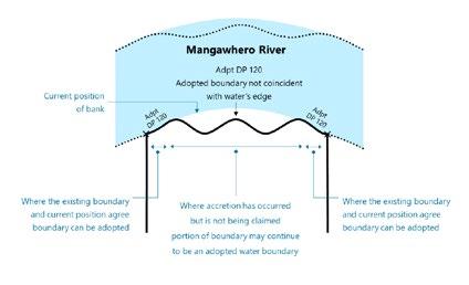

Figure 4: Screenshot of a Ctrl+F search on the Guidelines Index page
While we will still be updating these articles and adding additional material over time, we are at the tail-end of this project. It has been a huge team effort across several groups within Toitū Te Whenua LINZ. And I don’t think I will be the only one to say that this has been a tremendous undertaking, working with fantastic knowledgeable surveyors and that we are all very proud of the result. We can only hope that we have met our goal and that you find the guidance informative and useful too.
In addition to the guidance articles themselves and the index to the guidance, we have also created a CSR 2021 implementation page. This web page is a great resource that I recommend saving as a shortcut on your desktop. We have created this page as a “one-stop-shop” for all your CSR 2021-related needs. It has links to the rules themselves, the guidelines index, the clarification page, the lodgement standards, the Landonline pre-validation explanation report, known issues in Landonline and a training webinar to help you convert any existing RCS 2010 CSDs to CSR 2021. This page should be your first port of call when you have CSR 2021 questions.
The Survey & Spatial New Zealand Cadastral Stream is also running a programme, in partnership with Toitū Te Whenua LINZ, to present CSR 2021 Q&A sessions for local branches. These sessions have been really well received so

Figure 5: Screenshot of the CSR 2021 Implementation Page far. If your branch hasn’t hosted one yet and would like to, get in touch with Géneviève at gabrey@linz.govt.nz from the Cadastral Stream Leadership team to help you organise one.
And if you still can’t find what you are looking for, please email us at SGRulesReview@linz.govt.nz for a quick turnaround time on CSR 2021 rule-related questions.
The implementation page can be found at: www.linz.govt.nz/land/surveying/cadastral-survey-rules-2021-csr-2021-implementation
The Index to Cadastral Survey Guidelines can be found at: www.linz.govt.nz/land/surveying/cadastral-survey-rules-2021-csr-2021-implementation/cadastral-survey-guidelines •
Figure 6: Screenshot of the RCS 2010 to CSR 2021 Training Video
NOTES 1 Review of the Rules for Cadastral Survey 2010 – Issues and Opportunities Paper – 7 August 2017 (https://www.linz.govt.nz/land/ surveying/cadastral-survey-rules-2021-csr-2021-implementation/ review-consultation-process/stage-one-%E2%80%93-identifyingissues-rules) 2 Stage one – Identifying issues with the Rules – 23 September 2021 (https://www.linz.govt.nz/land/surveying/cadastral-survey-rules-2021-csr-2021-implementation/review-consultation-process/stage-one-%E2%80%93-identifying-issues-rules) 3 Interpretation Guide to Rules for Cadastral Survey 2010 – LINZG65700 – 6 December 2011 4 Tidal Boundaries Guidelines – Flowchart – 15 February 2022 (https://www.linz.govt.nz/kb/944#flowchart) 5 Field Survey Guidelines – Horizontal Datum Connection – 05 April 2022 (https://www.linz.govt.nz/kb/939#connection) 6 Water Boundaries Guidelines – Accretion – 15 February 2022 (https://www.linz.govt.nz/kb/943#accretion)
(continued from page 34) utility interest, however, in the case of a capital improvement fund, the levies are worked out in proportion to each unit owner’s ownership interest.
In many bodies corporate, ownership interests and utility interests will be one and the same, unless the body corporate has resolved to reassess utility interests.
If you are unsure about your obligations, it pays to take legal advice, as using the wrong fund can later lead to issues if challenged by owners. •


