WANCHEN WANG
SELECTED WORK SAMPLE 2019-2024
Contents
Hilton Head Island, South Carolina
Mid Island Initiatives
Landscape master planning SD
Hilton Head Island, South Carolina
Chaplin & Crossing Park Master Plans
Recreational park redevelopment SD
Louisville, Kentucky
Waterfront Park Phase 4
Playworks Design SD/DD/CD
Louisville, Kentucky
University of Louisville Student Housing
Student housing landscape design SD/DD/CD/CA
Royal Oak, Michigan
Centennial Commons Downtown Park
Urban park landscape design SD/DD/CD
Grand Rapids, Michigan
Spectrum Health Transformation & Innovation Center
Healthcare landscape design SD/DD/CD
Cincinnati, Ohio
3CDC Imagination Alley
Pocket park landscape design SD/DD/CD
Cincinnati, Ohio
Cincinnati Public Radio
Urban landscape design SD/DD/CD
Columbus, Ohio
Sensenbrenner Park Renovation
Sunken landscape renovation SD
Suwanee, Georgia
ARC Suwanee Loop Planning
Pedestrian and bicycle loop study
02 01 04 03 06 09 05 08 07 10
Mid Island Initiatives
Hilton Head Island, South Carolina
Landscape master planning
Software used:
ArcGIS, Rhino, Grasshopper, SketchUp, Lumion, AutoCAD, Bluebeam
Adobe Suite, Procreate
Involvement:
Conceptual design
Programming and space planning
3D modeling
In house rendering
Cost Estimate
The Mid-Island Tract is bordered by William Hilton Parkway, and Union Cemetery and Dillion roads. The town of Hilton Head purchased this 103-acre former golf course site on 2013. The town visualize a tantalizing opportunity to create a first-class park to enhance the mid-island area and benefit a variety of community interests.As a central gathering space, the tract will reflect the desires of the community and be designed as a welcoming and sustainable nature park.

UNION CEMETERYROAD
THE HEART OF THE TRACT
CULTIVATED LANDSCAPES
ECO-PARK
ISLAND HERITAGE
ACTIVE PLAY
WILLIAM HILTON PARKWAY
UNION CEMETERY ROAD
DILLON ROAD
AIRPORT
01
Site Analysis
SITE WIDE
PATHWAY TYPOLOGIES OFF-STREET PARKING +

NATURAL SYSTEM EXISTING HABITATS
AUDUBON SOCIETY: ONLY
KNOWN RED-HEADED WOODPECKER NESTING COLONY ON ISLAND


PROGRAM COMPONENTS


SITE WIDE
PATHWAY TYPOLOGIES OFF-STREET PARKING +


ACTIVE PLAY

THE OF THE TRACT

1. SCULPTURAL FOUNTAIN + PLAZA
2. GREAT LAWN
3. MARTIN LUTHER KING JR. MEMORIAL
4. PLANT BEDS
5. TERRACE SEATING
6. MULTI-USE COMMUNITY FACILITY
7. TERRACE
8. PLAYGROUND + NATURAL PLAY
9. INTERACTIVE FOUNTAIN
10. DILLON ROAD ENTRANCE
11. STREAM + POND RESTORATION

THE OF THE TRACT

1. SCULPTURAL FOUNTAIN + PLAZA
2. GREAT LAWN
3. MULTI-USE COMMUNITY FACILITY
4. TERRACE
5. PLAZA / DROP-OFF
6. PERMEABLE PARKING
7. PLAYGROUND + NATURAL PLAY
8. INTERACTIVE FOUNTAIN
9. DILLON ROAD ENTRANCE
10. STREAM + POND RESTORATION
11. MULTI-USE RECREATION LAWN
12. ECO-PARK
13. DOG PARK

1 2 3 4 4 7 8 9 5
10 11 6
1 2 3 5 6 6 7 8 9
11
13 4
10
12
ECO-PARK
LANDSCAPES
THE HEART OF THE TRACT CULTIVATED
ISLAND HERITAGE
Site Plan & Program Components

1. MULTI-USE COMMUNITY BUILDING
2. OPEN AIR MARKET
3. EVENT LAWN
4. COMMUNITY CULTURAL GARDENS
5. ORCHARD
6. GARDEN SHED
7. PERMEABLE PARKING
8. PLAZA / DROP-OFF
9. GRASSLAND

CULTIVATED LANDSCAPES


ECO-PARK

1. ECO-CENTER
2. OUTDOOR LEARNING
3. PERMEABLE PARKING
4. MULTI-USE TRAIL
5. STREAM + POND RESTORATION
6. BOARDWALK
7. ECO-PARK

1. THE ALAMEDA
2. SWINGING BENCHES
3. MULTI-USE PATHWAY
4. FLEXIBLE OPEN SPACE
5. ALAMEDA GARDENS
6. MONET GARDEN
7. LOWCOUNTRY BOTANICAL GARDENS
8. GREAT LAWN
9. MULTI-USE COMMUNITY FACILITY
ECO-PARK

1. CANOPY WALK
2. PERFORMANCE GROVE
3. ECO-PARK
4. MULTI-USE TRAIL
5. STREAM + POND RESTORATION

ISLAND HERITAGE
1 4 5 3 2 2 6 7 8 9 10
2 3 4 5 6 7 8 9 1 1
1 1 2 3 4 4 6 6 5 7
1 2 3 3 4 4 5 5
Chaplin & Crossing Park Master Plans
Hilton Head Island, South Carolina
Recreational park redevelopment
Software used:
ArcGIS, Rhino, SketchUp, Lumion, AutoCAD, Bluebeam Adobe Suite, Procreate
Involvement:
Conceptual design
Programming and space planning
3D modeling
In house rendering
Chaplin Park and Crossing Park are two of the Island’s largest and most diverse recreational and community parks. It provides a lot of active and passive recreation opportunities for residents and visitors to the Island. Today, many of these features are getting old and there are a lot of new ideas for how the open space in the park can be used for other things.In this project, we advocate for the development of concept plans aimed at reimagining these two beloved parks, fostering the creation of innovative recreational facilities and revitalizing their overall landscape for the benefit of the community.

02


 NATURAL
NEIGHBORHOOD AMENITIES
ISLAND - WIDE RECREATION
CROSSINGS PARK
CHAPLIN PARK
Conditions Program Components
MID ISLAND PARK Existing
Chaplin Park
Crossing Park
MULTI-USE FIELDS

DESTINATION PLAYGROUND
MULTI-USE FIELDS
MULTI-USE PARK
PARKING
FOOD TRUCK PLAZA
PATHWAY
BURKES BEACH
FACILITY
Chaplin Park Birdseye Rendering
PARKING

FLEXIBLE-USE OPEN SPACE
DESTINATION PLAYGROUND
BALLFIELDS
CHAMPIONS WALK
NATURE PARK
CHAMPIONS PLAZA
Rendering
Crossing Park Birdseye
Waterfront Park Phase 4
Louisville, Kentucky
Playworks Design
Software used:
Rhino, SketchUp, Lumion, Quest/Oculus, AutoCAD, Bluebeam, Squarespace, Adobe Suite
Involvement:
Conceptual design
3D modeling, In house rendering
3D rendering coordination
SD, DD, CD documentation
Architects, Civil, consultants coordination
Project website building
Augemented reality scene setup
Located in the Portland neighborhood within West Louisville, the site is critical in reconnecting West Louisville with downtown, and expanding the riverfront revitalization started with the first phases of Waterfront Park. The first component of Phase IV to be constructed, is the outdoor experiential learning area called PlayPort at Waterfront Park. PlayPort is a 1.5 acre park that celebrates the waterfront’s industrial roots by using authentic artifacts as the catalyst for families and kids to “Make Play Out of Work.” Visitors will have the opportunity to play and explore around authentic industrial artifacts that let them turn a towboat propeller or role play as an excavator operator.

03


Graphic Representation


Construction Documentation
Project Website


Construction Documentation Customized Details
University of Louisville Student Housing
Louisville, Kentucky
Student housing landscape design
Software used:
Rhino, SketchUp, Lumion, AutoCAD, Bluebeam, Adobe Suite
Involvement:
Conceptual design
Programming and space planning
SD, DD, CD documentation
Construction administration
Architect, MEP, Civil, consultants coordination
In house rendering


04


Typology
Quadrangle + Commons

Social Spines


Contexts
Site and
Current Uses Shadows
Site + Open Space Planning


Construction Documentation


Construction Documentation
Centennial Commons Downtown Park
Royal Oak, Michigan
Urban park landscape design
Software used: ArcGIS, UrbanFootprint
Rhino, SketchUp, Lumion, AutoCAD, Adobe Suite
Involvement:
Conceptual design
Programming and space planning
SD, DD, CD ducumentation
In house rendering
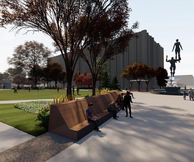
Oak Downtown Park


Royal Oak Downtown Park
nature play/ library terrace library the glade Oak Grove water feature City Hall gateway entry grove confluence gateway 3rd Street Gateway new City Hall henry ford outpatient facility Parking Garage
Hill boulder climb S main St
3rd St
The
e
the glade stage Oak Grove water feature City Hall gateway confluence gateway 3rd Street Gateway star dream plaza library terrace shade canopy library henry ford outpatient facility Parking Garage S main St e 3rd St
downtown is destiperimeter This community evolution
05


Events Programming
Holiday Market Memorial
Concert


MATERIAL COMPARISON CENTENNIAL COMMONS FOUNTIAN PAVERS COLDSPRING GRANITE PAVERS 24” 24” 1/2” OVERSIZED, AND CUT PAVERS MESABI BLACK, PRAIRIE BROWN, AND SIERRA WHITE PLAZA PAVERS UNILOCK CONCRETE PAVERS 8” 24” 4” PAVERS OPAL, BROWN, AND IL CAMPO IL CAMPO MESABI BLACK FOUNTAIN HEAD OPENING BROWN PRAIRIE BROWN OPAL Paving Study Customized Details Customized Details






MKSK BUILT WORK THE OHIO STATE UNIVERSITY, COMPLETED 2013 MKSK BUILT WORK THE OHIO STATE UNIVERSITY, COMPLETED 2013 ADA accessible sloped walk at 4.3% Handrail Customized Details
Spectrum Health Transformation & Innovation Center
Grand Rapids, Michigan
Healthcare landscape design
Software used:
Revit, Rhino, Lumion
Adobe Suite
Involvement: Paving study
3D Modeling
In house rendering
DD, CD documentation


06


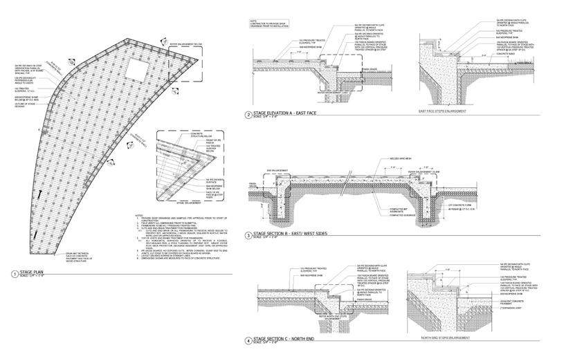
Construction Documentation Customized Details


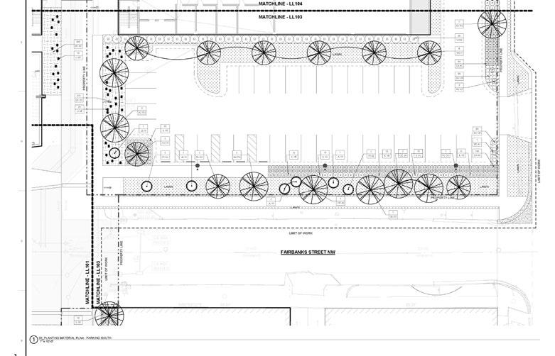

Site Plan Construction Documentation


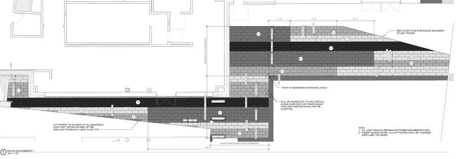


Customized Details
3CDC Imagination Alley
Cincinnati, Ohio
Pocket park landscape design
Software used: ArcGIS, UrbanFootprint, SketchUp,Lumion, AutoCAD, Bluebeam, Adobe Suite
Involvement: Conceptual design
SD, DD, CD documentation
MEP, Civil, Lighting,Furnishing consultants coordination
In house rendering


Events Programming


07


Construction Documentation Customized Details
Cincinnati Public Radio
Cincinnati, Ohio
Urban landscape design
Software used: ArcGIS, UrbanFootprint, Rhino, Grasshopper, Lumion, AutoCAD, Bluebeam, Adobe Suite
Involvement:
Conceptual design
SD, DD, CD documentation
Architect, MEP, Civil, Lighting, LiveRoof System consultants coordination
In house rendering


08


Customized Details
Sedum Roof Construction Documentation
Sensenbrenner Park Renovation
Columbus, Ohio
Sunken landscape renovation
Software used: ArcGIS, Rhino, Lumion, AutoCAD, Bluebeam, Adobe Suite
Involvement:
Site Survey
Conceptual design
SD, DD documentation
Lighting consultants coordination
In house rendering
Design presentation
Sensenbrenner is a downtown corner park, with flower gardens, a fountain, picnic tables, benches, and shade trees. The dedication took place on September 18, 1980 in honor of M.E. “Jack” Sensenbrenner, the former mayor of the City of Columbus. However, over time, the sunken garden has lost its allure, with aging elements casting a shadow over its once vibrant ambiance. The fountain, dormant for years, yearns for rejuvenation. To breathe new life into this beloved space, we offer innovative concepts to transform the fountain into a vibrant planting bed, revitalizing the park for generations to come.


09


RO DR EL AR 70 JU HO 34 TH OC RO DR JU CO 18 SE PE 30 CA AC 15 HE MR 29 TH OC RO DR PE AL 14 HE MR 27 SP 12 LE BC 14 SE 58 SE PE 10 CA AC PE AL 17 JU CO 14 SP JA 20 CA AC SE PE 10 LI SP EL AR 68 RO DR JU CO 10 CA AC SE PE 16 B L3.00 L3.00 2 2 QC QC C 1. SECURE PLANT MATERIAL AS SPECIFIED ON PLANS. SUBSTITUTIONS FOR PLANT MATERIALS WILL NOT BE ALLOWED WITHOUT PRIOR WRITTEN APPROVAL BY THE LANDSCAPE ARCHITECT 2. PROVIDE PLANT SAMPLES OR PHOTOGRAPHS OF EACH PLANT SPECIFIED TO THE LANDSCAPE ARCHITECT FOR COMPLIANCE REVIEW PRIOR TO INSTALLATION. 3. PROTECT PLANT MATERIAL DURING DELIVERY TO PREVENT DAMAGE TO ROOT BALLS, TRUNKS, BRANCHES AND THE DESICCATION OF LEAVES. PROTECT PLANT MATERIAL DURING SHIPPING WITH SHADE CLOTH OR SHIP WITH ENCLOSED TRANSPORT. MAINTAIN PROTECTIONS AND HEALTH OF PLANT MATERIAL STORED ON SITE. HANDLE TREES WITH NYLON STRAPS. NO CHAINS OR CABLES WILL BE ALLOWED. REMOVE UNACCEPTABLE PLANT MATERIAL IMMEDIATELY FROM THE SITE. 4. PLANT MATERIAL DELIVERED TO THE SITE IS SUBJECT TO THE REVIEW OF THE LANDSCAPE ARCHITECT BEFORE, DURING AND AFTER INSTALLATION. 5. VERIFY PLANTING PRODUCTS, PLANT MATERIAL, AND PLANT QUANTITIES DELIVERED TO THE SITE MATCH WHAT IS INDICATED ON THE PLANS AND SPECIFICATIONS. 6. REFER TO THE PLANTING DETAILS FOR MINIMUM SIZE AND WIDTH OF PLANTING PITS AND BEDS, GUYING AND STAKING, MULCHING, AND OTHER PLANTING REQUIREMENTS. 7. ROOT BALLS SHALL CONFORM TO THE SIZE STANDARDS SET FORTH IN “AMERICAN STANDARDS FOR NURSERY STOCK”. 8. PLANT MATERIAL DELIVERED TO THE SITE IS SUBJECT TO THE REVIEW OF THE LANDSCAPE ARCHITECT BEFORE, DURING AND AFTER INSTALLATION. 9. PLANT MATERIALS, INCLUDING RELOCATED PLANT MATERIAL, SHALL BE PLANTED IN A PROFESSIONAL MANNER TYPICAL TO THE INDUSTRY STANDARDS OF THE AREA TO ASSURE COMPLETE SURVIVABILITY OF PLANT MATERIALS AS WELL AS TO PROVIDE AN AESTHETICALLY APPROVED PROJECT. 10. REMOVE PLANTING AND LANDSCAPE DEBRIS FROM THE PROJECT SITE AND SWEEP AND WASH CLEAN PAVED AND FINISHED SURFACES AFFECTED BY THE LANDSCAPE INSTALLATION. 11. PLANTING AREAS SHALL BE WEED FREE PRIOR TO PLANTING INSTALLATION AND MAINTAINED WEED FREE THROUGH FINAL ACCEPTANCE. PLANTING NOTES 0 5' 10' 2.5' P:\2008\c8017-Arena_District_Master_Plan_08\Sensenbrenner Park\BIM_CAD_GIS\CAD\Sheets\L5-PLANTING PLANS.dwg Sep 08, 2023 5:04 QTY LABEL COMMON NAME LATIN NAME SIZE SPACING CONDITION EVERGREEN SHRUBS EACH JU CO JUNIPERUS CON. 'BLUE PACIFIC' BLUE PACIFIC JUNIPER #3 O.C. CONT EACH JU HO JUNIPERUS HOR. 'BAR HARBOR' BAR HARBOR JUNIPER #3 O.C. CONT EACH RO DR ROSA ©DRIFT 'CORAL DRIFT' CORAL DRIFT ROSE #2 PER PLANS CONT EACH SP JA SPIRAEA JAPONICA 'GOLDMOUND' GOLDMOUND SPIREA #3 PER PLANS CONT EACH TH OC THUJA OC. 'LINESVILLE' LINESVILLE ARBORVITAE #3 PER PLANS CONT PLANT SCHEDULE QTY LABEL COMMON NAME LATIN NAME SIZE SPACING CONDITION NOTES PERENNIALS EACH HE MR HEUCHERA 'MIDNIGHT ROSE' MIDNIGHT ROSE CORALBELL #1 12" O.C. CONT EACH IB SE IBERIS SEMP. 'FIRST FLUSH' FIRST FLUSH LAVENDER CANDYTUFT #1 12" O.C. CONT EACH LE BC LEUCANTHEMUM 'BANANA CREAM' BANANA CREAM SHASTA DAISY #1 18" O.C. CONT EACH LI SP LIATRIS SPICATA 'KOBOLD' KOBOLD BLAZING STAR #1 18" O.C. CONT EACH SE PE SEDUM 'PURPLE EMPORER' PURPLE EMPORER SEDUM #1 18" O.C. CONT ORNAMENTAL GRASSES EACH CA AC CALAMAGROSTIS A. 'AVALANCHE' AVALANCHE FEATHER REED GRASS #2 18" O.C. CONT EACH EL AR ELYMUS ARENARIUS 'BLUE DUNE' BLUE DUNE LYME GRASS #1 15" O.C. CONT EACH PE AL PENNISETUM AL. 'FOXTROT' FOXTROT DWARF FOUNTAIN GRASS #2 18" O.C. CONT CODED NOTES NEW PLANTING AND IRRIGATION CONNECTION TO BE ALTERNATE. REMOVE EXISTING PLANTING MATERIAL IN THIS AREA.. INSPECTION RISER PROVIDE DRIP IRRIGATION IN ALL PLANTING BEDS PROVIDE 1" IRRIGATION CONDUIT 1. DIG OUT 18" OF EXISTING SOIL AND REPLACE WITH NUTRIENT RICH PLANTING SOIL AT EXISTING PLANT BEDS 2. USE KURTZ BROTHERS PROFESSIONAL BLEND TOPSOIL AT ALL AFFECTED PLANTERS. TOPSOIL TO BE MANUALLY COMPACTED TO 90%. SOILS NOTES 1. IRRIGATION SYSTEM SHALL INCLUDE DRIP IRRIGATION ONLY TO PLANT BEDS AFFECTED BY THIS PROJECT, RAIN SENSOR AND RAINBIRD IQ CONTROL SYSTEM. 2. UTILIZE EXISTING FOUNTAIN PLUMBING AND CONDUITS FOR IRRIGATION ROUTING 3. COORDINATE P.O.C, ELECTRICAL NEEDS, CONTROLLER LOCATION, ROUTING, ETC IN THE FIELD PRIOR TO START OF CONTRACTION. 4. ALL CONDUIT SHALL BE PLACE BELOW HARD SURFACES PRIOR TO HARDSCAPE INSTALLATIONS. PROVIDE CONDUIT AS INDICATED ON PLAN. IRRIGATION NOTES C IRRIGATION LEGEND CONTROLLER- COORDINATE FINAL LOCATION WITH OWNER/ CONTRACTOR QUICK COUPLER- COORDINATE FINAL LOCATIONS WITH OWNER/ CONTRACTOR 1" CONDUIT- COORDINATE FINAL LOCATION WITH OWNER/ CONTRACTOR QC Lighting Analysis & Design
Planting Documentation
10
ARC Suwanee Loop Planning
Suwanee, Georgia
Pedestrian and bicycle loop study
Software used:
ArcGIS, Rhino, Adobe Suite
Involvement: Conceptual design
Programming and planning
Suwanee is a city in Gwinnett County and a part of the Atlanta metropolitan area. We worked for Atlanta Regional Commission to do a bicycle and pedestrian study. Our goal is to connect existing parks, trails and community arts. In this project I worked with a planner to craft a concept document delineating the project’s alignment, typical sections, and strategic framework, positioning it optimally for future funding opportunities.
PROJECT GOALS
Builds on your Bicycle and Pedestrian Master Plan
Complete the Suwanee Loop that is amenitized
Develop a Brand
Sidewalk Feasibility Study (Martin Farm Road, White Street, Westbrook Road, Russell Street)
Existing Trails New Main Loop Segments New Neighborhood Connectors Sidewalk Feasibility Studies + + +
Suwanee’s existing trail system would form the backbone of the continuous loop system. These sections may be upgraded with features like improved wayfinding signs, system branding, stormwater management, and placemaking elements like art, landscaping, or trailside activities.
New segments would “fill in the gaps” for the remaining of the main loop route. Where feasible, these would be shared use paths to serve both pedestrians and cyclists and would be separated from vehicular traffic. In some cases like the Town Center, cyclists would use on-street facilities and pedestrians will walk on sidewalks.
New connectors would help people get from their neighborhoods to the main loop route. In most cases, these would be shared use paths next to streets, giving pedestrians and cyclists designated space away from vehicles.
The City is also studying the feasibility of adding sidewalks to two streets that would improve pedestrian mobility and access to the trail system. These will be standard 5-foot sidewalks for pedestrians; cyclists will continue to share the road with drivers on these streets.


K Bike Racks Qty: 13 POTENTIAL PLACEMAKING OPPORTUNITIES Locations of potential access points and furnishings along the draft loop route, including: Gateways Trailheads Connectors Trailheads occur where opportunities for vehicular parking exist along the route and are often associated with existing public amenities and civic institutions. Potential elements include: Vehicular Parking Restroom Wayfinding Signage Seating Trash Receptacles Water Refill Bike Parking Bike Repair Kiosk Lighting Gateways occur at major intersections of the trail system and major roadways. These prominent locations offer tremendous placemaking potential and should be highly amenitized and articulated. Potential elements include: Monumental Public Art Wayfinding Signage Seating Trash Receptacles Water Refill Bike Parking Bike Repair Kiosk Lighting Connectors occur where the route intersects existing roadways, trails, and public ways. These neighborhood connections improve accessibility and connectivity to the surrounding Suwanee community. Potential elements include: Wayfinding Signage Seating Trash Receptacles Lighting W A H S B C Bike Repair Kiosk Qty: 5 Trailside Amenities Legend Seating Qty: 23 Wayfinding Signage Qty: 19 Monumental Public Art Qty: 3 Water Refill Qty: 6 Comfort Station Qty: 0 T Trash Receptacle Qty: 23 Eva Kennedy Rd CHARACTER AREA COMPOSITE Buford Hwy Scales Rd White St Park McGinnis Ferry Rd Playtown Martin Farm Park Town Center Park Station Park Town Center on Main Brushy Creek Greenway Suwanee Creek Greenway “The Thread” “The Boulevard” “The Meander” “The Promenade” Main St Park Peachtree Industrial Blvd Fun Hogs: Pale Periwinkle B B B B G B B G W1 W1 W1 W1 W1 W1 W1 W1 A A S2 B1 W2 W1 K2 B1 H1 T2 W1 W1 W1 W1 W1 W1 B1 B1 B1 B1 B1 K2 K2 K2 K2 K2 T2 T2 T2 T2 T2 T1 H1 H1 S1 S1 S1 S1 S1 S1 S1 H1 S1 H1 H1 S2 S2 T1 T1 T1 T1 T1 T1 T1 W1 S2 T1 S2 S2 S1 T C T C T W1 S2 T2 A G C C C T C C T C C C
One Trail, Four Character Areas
The




following boards examine the unique character and qualities of the loop trail. Here we explore what will draw people to the trail, and what will keep them talking about it long after they’ve loaded their bikes or kicked off their shoes. Active, Friendly, Refined The Promenade connects Suwanee’s signature parks and premier destinations.
The Promenade Highly-Ref ned Urba
Pede treetscape Element Art&Sculpture ns a at ons Naturalistic, Serene, Diverse The Meander encompasses Suwanee’s greatest natural resources: the Suwanee Creek. The Meander Rip tRestoration Artful Signage ind i n g P aces for Re erpret at i o n E ntal Art & Sc &Educat on
Suwanee Loop Trail
Suwanee Creek S t r eamb tion & izati Elevated Boardwa Overlo retive Features vironmental Sculpt u r e iparian Natural Enviro Se hrough F oodplain D ation Wetland noP
Suwanee Loop Trail
Creek TYPICAL ACTIVATION SECTION TYPICAL RESTORATION SECTION THE PROMENADE Active, Friendly, Refined THE MEANDER Naturalistic, Serene, Diverse THE BOULEVARD Energetic, Vibrant, Welcoming THE THREAD Eclectic, Neighborly, Approachable
Suwanee Loop Trail
Suwanee


Art a on Path
Boulevard
front door to the greenway and trail system.
&
Median withBioretentionandNative P l a n t s NativeOrnamental Grass and ShrubBuffer
Energetic, Vibrant, Welcoming The
proposes a new
The Boulevard Sculptures
Wayfinding
Travel
Southbound Travel
Art and Concrete E ements Nat ve Grasse
and Sculpture
Suwanee Loop Trail
Lanes
Lanes Northbound
EnvironmentalArt
Suwanee Creek
Suwanee Creek
Suwanee Loop Trail
TYPICAL MCGINNIS FERRY RD SECTION
Approachable
dPlantings & Pollinat Place ation & Interpretati A tr f u l Sig n finding ologically Performat ture
Suwanee Loop Trail
Eclectic, Neighborly,
The Thread weaves its way through Suwanee’s historic district and emerging neighborhoods. The Thead
Suwanee Loop Trail
nsitive Publ c Art & Scul O pretive Features arian Forest Restora ment
TYPICAL SCALES RD SECTION
Suwanee Loop Trail
Brushy
Creek


THE THREAD

THE PROMENADE THE MEANDER THE BOULEVARD


 NATURAL
NEIGHBORHOOD AMENITIES
ISLAND - WIDE RECREATION
CROSSINGS PARK
CHAPLIN PARK


