
2 minute read
SW Louisiana farm family continues and Floods aid expansion


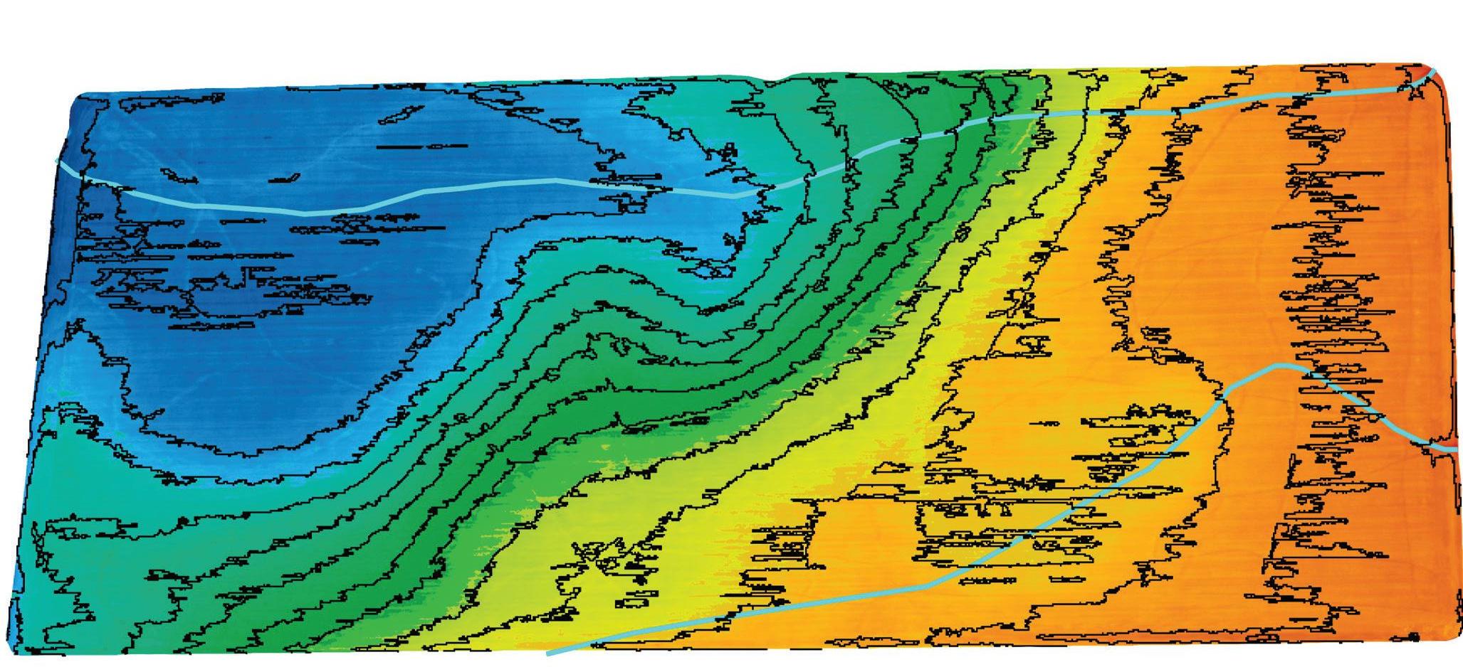
A soybean field surveyed for levees with a 0.35 drop and ditches.
The same field mapped for rice and levees with a 0.2 drop and the same ditches. The jaggedness of the levees, which will be smoothed before the map is used, is caused by dirt clods or other minute rises in the landscape.
elevation must either be smoothed and ready for planting or at least have the stubble mowed closely to the ground, Pickett said.
Large dirt clods, ruts or tall plant material will interfere with the cameras and distort the results.
Fortunately, Matthews said, he was able to get some fields prepared after the 2020 harvest, unlike the previous few falls, which were marked by abnormally wet conditions and rutted fields.
“You have to have smooth ground,” he said. “The last three to four years, we had trouble with wet harvests, and we had trouble getting rid of the stubble. All of those things can work against you.”
In one of his rice fields, Matthews also had a spot that produced lower yields according to his yield maps.
By overlaying Pickett’s elevation map with the yield map, Matthews found the spot was only a fraction of a tenth higher than the rest of the field.
But that inch or so meant the spot dried out quicker, stressing the rice and reducing yields.
Elevation also is one of the variables entered into computerized hole-selection software for furrow irrigation.
If the grower plants to run the tubing down one side of the field, Pickett said he only needs to fly that area to measure the elevation.
But if the grower plans to run the piping down the middle, he’ll fly the entire field to determine the center of the ridge where it should be placed. A land-leveling tool
Pickett, who has used drones with GPS RTK to survey fields and develop cut maps for land leveling, said he believed that’s a market with strong potential.
Matthews agreed, saying he was impressed by the cut maps’ precision and usefulness.
“And it’s so much more accurate,” he said. “A truck drives your field on a cut sheet and a lot are driving 100-foot swaths, some are driving 50 feet. That drone can actually fly foot swaths.”
Elevation data and resulting cut maps also can be used to determine whether it is more cost effective to level a field intended for crops other than rice or install a center-pivot irrigation system, Pickett said.
The next 1%
But for Matthews, the technology is all about helping him move closer to his goals.
“I’m looking to get 1% better,” he said. “If I get 1% better, that will lead me to the next 1%, and that will lead me to the next 1%. That’s how close we are. For me, it’s achieving better irrigation efficiency in a critical groundwater area. I know it’s a lot of work and a lot of technology. But any time we can improve by just a percent or two, it’s going to make a difference in our costs and our yields.”


