14 minute read
HIGHWAY 37


EXPERIENCING THE WONDER OF BC’S NORTH
BY RICK HUDSON
Advertisement
Archie says it’s a go, and he’s been driving the Stewart-Cassiar since, well, since the other Trudeau was Prime Minister. You can’t go wrong with my friend Archie. He knows a thing or two about Highway 37. He’s had more adventures there than Rick Mercer has had rants, and that’s saying something.
So, we’re heading north, leaving Highway 16 and the Lake District behind, and rolling into the great unknown. To us. To Archie, those 725 paved kilometres (give or take) are old hat and that’s why we’re going with him.
We start at Kitwanga after crossing the mighty Skeena River. It’s the second longest river fully in BC (after the Fraser) at an impressive 580 kilometres, but who’s counting, eh? The Skeena is an important salmon river, especially for sockeye, and starts way up north on the Spatsizi Plateau, where we’re headed. Which is where the Stikine, Nass and Dease rivers start too, only they go west, southwest and north, while the Skeena flows south. By the time it passes Kitwanga, the Skeena is well over halfway to the sea at Prince Rupert, and over 200 metres wide.
We fill up at the gas station on the corner of 16 and 37 and then drive over the Skeena bridge. Archie advises that the bridge was built in 1974, replacing the old rail and road bridge about a mile upstream. That one was built in 1925 and replaced a ferry service. “Progress,” says Archie, “it’s all about progress.”
The road itself has a good surface, and the traffic dwindles quickly, mostly just commercial trucks and the occasional RV
(like us). Highway 16 and 37 are a popular alternative to the Alaska Highway. It’s slightly shorter but no quicker. Mostly, it’s just different, and you’ll see a lot fewer vehicles than the other route. Plus, it visits some equally interesting places that in Archie’s opinion … but you don’t want to hear what Archie thinks. Right now, we’re rolling north and the road demands our full attention as one curve follows another.
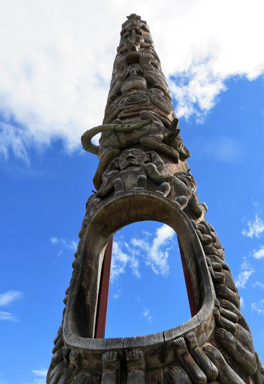
AT GITANYOW WE turn left off the road and drive into the Gitxsan village where there are towering totems to be seen. During Covid, the village closed to outsiders and underwent a significant upgrade in roads, with much new paving. Open for tourism again, the village’s poles are special for a number of reasons. After the potlatch ceremonies were banned in the late 1800s, totems were carried off to many museums around the world. Many of the original Gitanyow poles ended up in the BC Museum in Victoria and were replaced with replicas, including the “Hole in the Ice” or “Hole in the Sky” totem that was erected in 1850. So, these are some of the oldest poles still standing. Marvel at the skilled craftsmanship, and know that each tells a story about origins, clan relationships, property rights or more.
It was here and in neighbouring Kispiox that artist Emily Carr painted some of her most famous totem canvases. The rows of traditional longhouses she recorded have gone, replaced by modern homes, but the aura remains. This is a special place. We park in front of the grocery store and wander around in quiet respect. Even Archie is silent.
The nearby Meziadin River has been the lifeblood of the Gitxsan people since time immemorial and Meziadin Lake up north is the heart of sockeye country. The lake is where a paved road runs west (the 37A) down to the coast at Stewart. “Not to be missed,” says Archie, so we gas up at the junction and turn to follow the setting sun over Bear Pass. The highway climbs 200 metres to Strohn Lake, where we pull off on the gravel verge and take a walk. There’s a westerly howling through the gap in the mountains, and the muddy surface of the lake is being whipped into a steep chop.
Across the lake is the Bear Glacier. Archie cups his hands to his mouth so we can hear above the wind. “That ice has retreated a whole lot in just five years since I was last here,” he says. “Pretty soon it’ll be out of sight.” It drains the north side of Otter and Cambria peaks. Although the icefield above will still be there for decades, the white tongue of ice curving down to the lake—a great favourite with photographers—will be a thing of the past. Images from just a few years ago show the glacier at the lake; now, it’s melted upslope a long way.
IT’S RAINING IN Stewart, but that doesn’t detract from the small-town, friendly feel of the place. The old build- ings along 5th Avenue still have a pioneer feel to them, reminiscent of the gold and silver mining heydays of yore. Check the excellent museum for a history lesson. At the Visitor Centre there’s help and suggestions on what to do, and next to the centre there’s a raised boardwalk out across the salt marshes of the estuary. On sunny days it provides spectacular views of the town’s situation, sandwiched be- tween high peaks on either side (often snow-capped) and the Bear River. To the south, long, thin Portland Canal stretches 150 kilometres to the open sea; it’s the start of that great undefended 2,500 kilometre boundary between Canada and Alaska, all the way north beyond the Arctic Circle.
Just two kilometres down the road is the US border and the hamlet of Hyder
(pop. 60 in the winter). Because there’s nowhere to go from there (more on that in a minute) it’s one of the very few entrance points where there’s no Uncle Sam waiting. But don’t forget to take your passport, because you’ll want to get back into Canada, and there is a Canadian Immigration post on your return!
When the salmon are running in midJuly to September, one of the north’s best experiences is just beyond Hyder at the Fish Creek Wildlife Observation Site. A raised walkway parallels the river, and it’s a favourite spot for bears to hunt pink and chum salmon. Hang over the rails and watch what’s happening below in relative safety. Signs remind you not to walk on the roads (bears walk on the roads) and to be careful getting out of your vehicle in the car park (bears wander through here too).
On that same road, and the highlight of many people’s trip to the region, is a visit to the Salmon Glacier at the head of the valley. It’s a 39-kilometre drive from Stewart through Hyder and up a long, switchback road. Archie doesn’t recommend it for RVs, but a competent 2WD vehicle will make it, with care. It’s an unpaved mine road that leads you back into the Canadian alpine (no border stops) and brings you out opposite the Salmon Glacier’s terminal. The guidebooks (and Archie) will tell you it’s the fifth largest in Canada. On a sunny day the view is extraordinary. The road transits above it, so you look down and across at a spectacular sweep of snow and ice that breaks up into crevasses and seracs at your feet. Bring warm clothes, cameras and lunch, to savour this natural wonder.
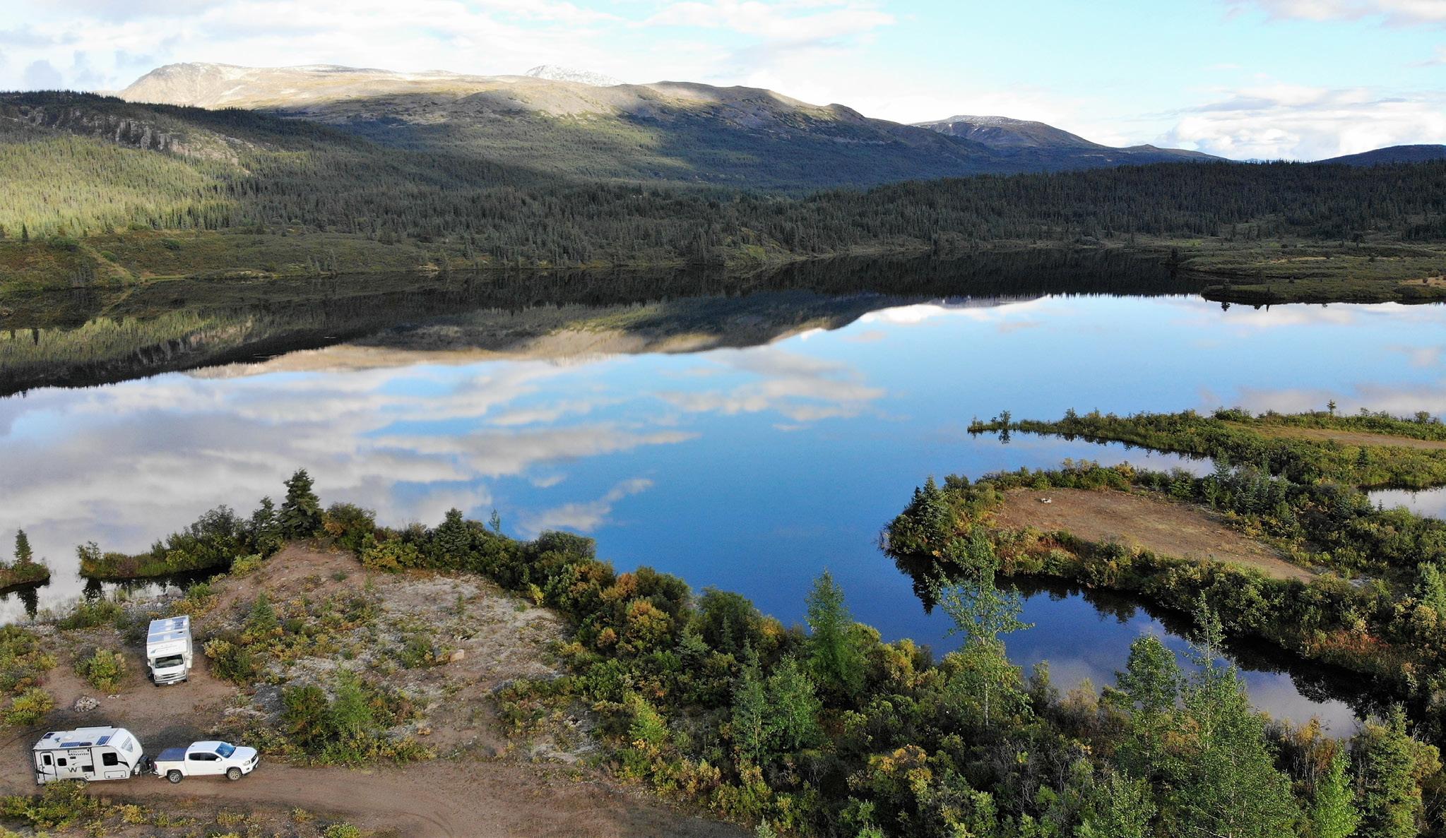
BACK AT MEZIADIN JUNCTION, it’s time to turn north again on Hwy 37. The highway follows a valley peppered with lakes on the west side. Many have provincial parks on them, but most are day-use or tent-camping only. Eighteenkilometre-long Kinaskan Lake is different. The south shore’s park has 50 RV sites, many with glorious views up the lake. Dawn and dusk produce some rich Kodak moments.
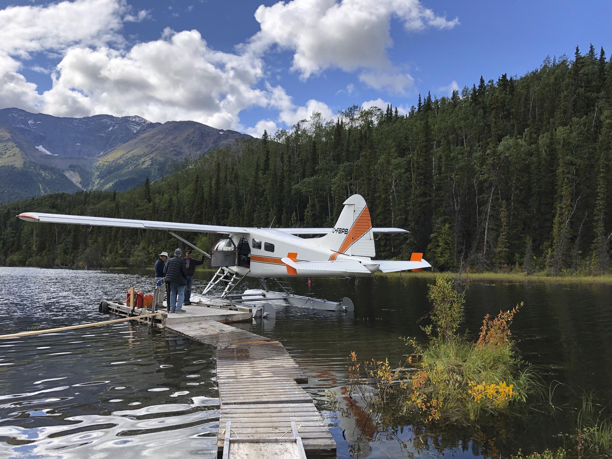
Just north of Kinaskan is Tatogga Lake. The Lodge is a must-stop if only to admire the mounted wildlife in the restaurant (the burgers are great too). We fall into conversation with a staff member who explains all the things to do in the region, with the aid of a large wall map. For much of the summer, Alpine Air has a floatplane at the lake, providing access to a host of remote locales both to the west (Edziza Provincial Park) and the east (Spatzizi Plateau Wilderness Provincial Park). It’s important to call their head office (in Smithers) and plan ahead. The summers are short and there’s all-day pressure to fly passengers into the backcountry to hike, fish, hunt, kayak, raft or just camp. June to mid-August are the busiest times.
At the check-in counter we give our names, and the lady behind the desk comments, “That’s an unusual surname. I used to teach at College of New Caledonia with someone by that name.” She stares at our masks. Then the light goes on. “Joan?” “Bob?” They fall on each other like the old friends they were 30 years ago. There’s much laughter and ribbing as masks are pulled off and they recognize each other.
“What brings you here?” “We were hoping to get into the Edziza,” says Bob, “but the plane at Tatogga has gone south already.” Joan’s eyes twinkle. “Ours hasn’t.
The temperature’s down and it’s still raining. Our waiter at the restaurant explains that because of the forecast, the floatplane has already left for its base down south. Archie’s language is colourful at this news. We had plans to fly into the Spectrum Range for a couple of days.
But wait—Archie has a Plan B. There’s sometimes a Klappan Air floatplane at Kluachon Lake a bit further north. After lunch we drive the short distance on Hwy 37 and then down the steep gravel road to Mountain Shadow RV Park. We’re all wearing Covid masks out of courtesy to the locals, who often regard us as nothing more than disease-carrying scruffs from the south.
My husband Keith has his plane here. He’s busy, but not THAT busy.” Archie grins. It’s karma. Or luck. Whatever it is, we’re all pleased.
But summer is over, it seems, and the rain keeps falling for the next two days as we wait for a weather window. The temperature stays close to zero at the lake, and when the clouds lift on the third morning, there’s snow on the tops of everything. We were hoping to camp 600 metres higher than where we are, so it looks sketchy. We discuss the options back and forth as the rain continues. Joan reports the forecast is improving tomorrow.
Archie puts it best. “We’re here, now.
Boya Lake in Tā Ch’ilā Provincial Park is famous for its turquoise waters, formed when pale marl (a limestone derivative) coats the bottom of the lake. In mid-summer the water is warm enough to swim.
Let’s make the most of the bad weather. We might not get to camp at 1,500 metres in ankle-deep snow, but we should make the effort to at least see the place.” We concur. Keith the pilot says he’ll take us flight-seeing.
THE NEXT MORNING dawns mostly clear, with fresh snow sparkling on the summits. The de Havilland Beaver climbs out of the valley, its rotary engine howling while Keith gives us a running commentary. He’s been a bush pilot, outfitter, hunter, helicopter base manager and married to Joan for over 50 years. He knows this territory like the back of his hand, and for the next hour and a half he shows us the wonders of the Edziza Plateau. By the way, it’s pronounced ‘edseye-za’. The name means ‘cinders’ in the Tahltan language.
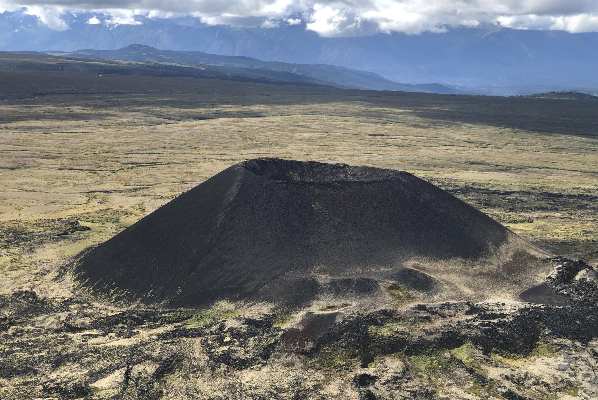
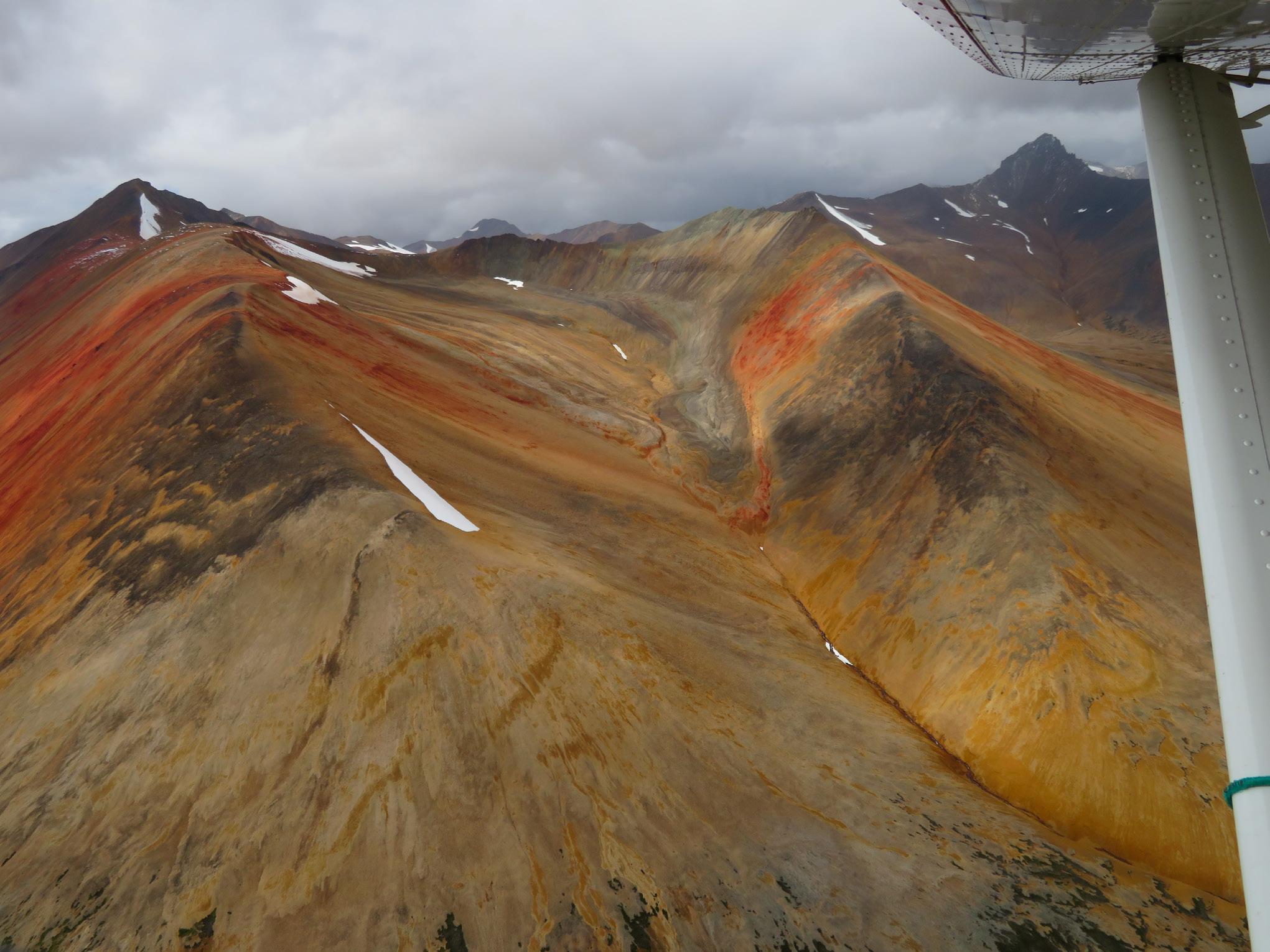
The park has no vehicle access. It was established in 1972, and encompasses 2,660 square kilometres of complex volcanic terrain. It’s part of the line of volcanoes that stretch right up the west coast of North America and into Alaska. Earthquakes are not uncommon. A 7.7 magnitude quake occurred near Haida Gwaii in 2012. The park’s rocks are young—about 7.5 million years old— with recent minor eruptions forming perfectly symmetrical cinder cones, unblemished by the last Ice Age.
As the plane gains height, we swing around the south end of the plateau and the orange and red tones of the wellnamed Spectrum Range come into view under the right wing. Such colours—the rhyolite hues enhanced by the white of freshly fallen snow.
The summit of Mount Edziza (2,780 metres) is well glaciated. The south side, which gets the prevailing sun, is more broken and crevassed than its counterpart on the north. What comes across as we slip in and out of pockets of cloud, always keeping the peak on our right, is how wild and barren it appears. It’s sand, gravel and black basalt with little vegetation. Only at key passes between the radiating hills do we discern faint tracks where animals and hikers have crossed from one valley to another. Otherwise, the region appears supremely untouched, the way parks ought to be.
North of the main peak, long lava flows run down to the edge of the Grand Canyon of the Stikine. There, that 600-kilometre-long river squeezes into a slot so deep and narrow that it resembles a knife-cut through the plateau. Keith turns the plane and we follow it upstream. In places it’s reported to be just three metres wide. Once considered ‘the last great problem of North American kayaking’ it was finally run in its entirety in 1990. However, such is the pace of extreme sports, 15 years later it was run in a single day. And in 2017, twice in a day! “There’s always one in the crowd,” says Archie.
WE’RE BACK ON the highway again.
As we drive away from Morchuea Lake, Archie observes that watersheds have always intrigued him. It’s not far before Hwy 37 crosses the Tanzilla River, which drains west into the Stikine and hence the Pacific Ocean. But just a short distance further we cross into a different catchment, where a raindrop starts its long journey via the Dease River into the Liard River, curving around the north end of the Rocky Mountains and hence into the Mackenzie River, ending up in the Arctic Ocean—a journey of nearly 4,000 kilometres. Northern Canada is huge.
On the divide we reach the somewhat uninvitingly named Gnat Summit (1,241 metres) where there’s a spacious pullout next to Upper Gnat Lake. Happily, it’s too late in the season for bugs. The sun is out and the surface reflects the blue sky, with a new dusting of snow on the hills across the water. Loons call from the lake as it turns into an iconic northern evening.
Above the highway we see the abandoned bed of BC Rail’s northern construction, never completed. It was Premier W.A.C. Bennett’s dream to drive a rail line to the Yukon boundary, but it never happened. The cost of crossing such complicated terrain turned out to be double the estimate. The project was finally shelved in 1978, having gone 300 kilometres beyond Prince George to Dease Lake.
Talking of Dease Lake, the next morning we halt there to gas up, but the Petro-Canada is more than just a fuel stop. The outfitter’s store has everything you would ever need to hang out in the north, from snowshoes and work boots to hunting and fishing gear and bug spray. Whatever you forgot to pack in the south, it’s likely they’ll have it, in three sizes and two different colours. This continues a longstanding trading tradition: Dease Lake town is close to a Hudson’s Bay trading post known as Lake House, founded in 1837.
The Telegraph Creek Road runs southwest from town. Under better conditions we’d take the time to explore it, but bad weather and the fact there’s a washout and construction dissuades us from trying it this trip. It’s 112 kilometres of unpaved road and there are no services at the end. Be self-sufficient. If you think it’s tough driving, consider the great Canadian geologist George Dawson, who explored much of the region. It took him two and a half days on horseback to reach Telegraph Creek from Dease Lake back in 1887.
On the way down, at the confluence of the Stikine and Tahltan rivers is the Tahltan community. On the canyon wall across the river is an impressive basalt cliff known locally as Sesk’iye cho kime (pronounced ‘sis-kai-cho-kima’). It means ‘home of the crow.’ The bird’s spread wings are obvious; the feathers are comprised of vertical basalt columns, to dramatic effect.
Telegraph Creek has a population of about 250 permanent residents, and an interesting history. A prime fishing spot for the Tahltan First Nations, in the 1860s a telegraph company planned to use it as the start of an underwater cable to Europe (“That doesn’t make a blind bit of sense,” says Archie) via the Bering Strait, but lost out to a trans-Atlantic cable that ran from Newfoundland to Ireland—a considerably shorter distance. Nevertheless, the name ‘Telegraph Creek’ stuck. In the 1870s it became a starting point for numerous gold rushes to Cassiar, Cariboo and Klondike.
A DAY LATER we drive past Good Hope Lake and turn down at Boya Lake. The park was recently renamed Tā Ch’ilā Provincial Park, which means ‘blanket full of holes’—for the many bodies of water which fill the valley. There are 42 campsites, many on the lake. The water is a pale blue-green, lightened by dissolved white marl on the bottom, a result of erosion from upstream limestone peaks. It’s shallow and often warm, making for a rare swimming opportunity in the north. Canoe and kayak rentals are available from the Park Facilities Operator. Despite a moderately full campground, it feels like we have the whole of northern BC to ourselves when we paddle among the islets. Recently gnawed aspens show where beavers have sourced their building material for a dam upstream. Archie advises there’s a local legend that says when the yellow swallowtail butterflies arrive at Boya Lake, the salmon are running at Tele- graph Creek. There are many butterflies. A day or two later we drive the final 86 kilometres to Hwy 37’s junction with the Alaska Highway, aka Hwy 97. Just 23 kilometres east is Watson Lake; Whitehorse is 420 kilometres to the west. But Hwy 37 is over. “Well,” says Archie, “wotcha think, eh?”
Alexander Mackenzie passed the confluence of the Liard and Mackenzie rivers in 1789 and in 1803 a fur trading station was established there— later named Fort Simpson. In 1834, John Macleod reached the headwaters of the Dease River which was home to what today would be known as the Three Nations (Tahltan, Kaska and Tlingit peoples). He noted birds’ nests lined with yellow fibre, and fabrics woven from ‘mountain goat wool’ that didn’t burn. This was the unknown mineral asbestos.
In 1949, a Geological Survey of Canada expedition spent four days at McDame Mountain and positively identified the mineral, but due to its remoteness, assumed it wouldn’t be developed for decades. Yet that same winter a prospector sledded in and staked the first of many claims. The race was on!
With improved access via the Second World War-built Alaska Highway, the Cassiar Asbestos mine started, as the demand for this new wonder material rose. It was used in vehicle brakes, non-flammable cloth, high-strength concrete and house insulation, to name just a few applications. Fibrous and fire-proof, it seemed to have an infinite number of uses.
An open pit mine started in 1951 under McDame Mountain, and the town of Cassiar followed, six kilometres to the south. By the 1970s, there was a population of 1,500 and a booming economy with schools, churches, a sports arena, a small hospital and even a theatre.
Mining was done by blasting in the pit, with the ore carried via tramline down to a mill. As they moved round the pit, miners noticed that one zone had a particularly hard rock which was of no apparent value. It was dumped, while the asbestos mining continued.
Jade was not a wellknown mineral back then, although a prospector, Bill Storie, had identified it on his claims on Wheaton Creek east of Dease Lake, in 1938. In 1967, one of the mine’s mechanics, a man named Clancy Hubble, who was also a rockhound, became intrigued by the hard rock waste. He sent a sample to the Dept. of Mines in Vancouver for analysis. The report confirmed it was nephrite jade. The mine bosses had no interest in it, so Hubble got permission to stake the area where the waste had been dumped. He estimated there might be as much as a thousand tons of jade.
Within a few years the mine’s management began to realize their ‘waste’ was worth more per ton than their highgrade chrysotile asbestos! After some adjustments, most of the annual output (100 to 200 tons) was shipped to Taiwan. Initially, the buyers didn’t like the characteristic green chrome ‘fleck’ in the material, but later came to prefer it and paid a premium.
With rising concern about the link between asbestos and lung cancer, chrysotile sales began to drop in the 1980s. The need to stop open pit mining and go underground was an added financial hurdle. In 1992, Cassiar Asbestos closed. The mining equipment was sold off, as were buildings in the town, but most were simply dismantled, burned or buried. Today, a 12-kilometre drive west off Hwy 37 reveals another fascinating BC mining ghost town.