PARANA DELTA
New scenarios to link the delta dynamic with a sustainable development of the Lower Parana Delta
P5 Report -
Ana Paula Amieva Gomez

New scenarios to link the delta dynamic with a sustainable development of the Lower Parana Delta
Abstract
Motivation
Context
Problem focus
Problem statement
Proposition
Projection
The Paraná Delta, a vital component of the La Plata river basin, is facing severe environmental degradation due to human activities and external pressures. This thesis explores the adaptive capacity of the deltaic system and stakeholders in the ‘Los Pájaros y sus Pueblos Libres’ reserve (LPPL), aiming to propose a strategy for sustainable development of the delta as a whole. The study aims to investigate biophysical processes, governmental policies, and socio-economic and cultural characteristics related to the delta and to propose a strategy for enhancing and promoting sustainable development in the region. A thorough literature review has been conducted regarding relevant existing research and data collection has primarily relied on desk research, (GIS-)data sourcing, and policy documents. Additionally, interviews with experts have been conducted and a thorough site visit has been undertaken. The results of the research contribute to the understanding of the ecological value of deltas and reveal the critical environmental degradation and diminishing ecosystem services specifically in the LPPL area in the Paraná Delta. The thesis emphasizes the importance of adopting a multifaceted and integrated approach that addresses the challenges faced by the delta. It underscores the significance of developing an adaptation plan based on NBS and strongly considering and reviving local knowledge for socially and culturally acceptable solutions. Stakeholder engagement emerges as a crucial factor in fostering collaborations and partnerships that promote a collective system of care and enable sustainable practices. The proposed strategy also advocates for localized interventions that can serve as a driving force for positive change in the entire delta. Sustainable tourism is identified as a strategic tool for conservation and regeneration, raising awareness about the delta’s ecological value and diversifying the existing local economic model greatly dependent on intensive agricultural practices and responsible for the loss of ecosystems. Finally, the thesis challenges the existing conservation framework and proposes a more flexible and adaptive approach that recognizes the interconnectedness of the delta and its surrounding areas.
Keywords: Paraná Delta, Nature Based Solutions, Adaptive Capacity, Wetlands, Integrative planning
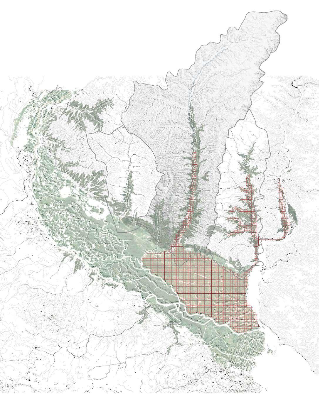
The Paraná Delta is embedded in the La Plata River Basin, the second biggest river basin of South America. Spanning over 3.100.000 km2, it covers 17% of the surface of South America. There are three main hydrological systems within the La Plata river Basin; the Uruguay-, Paraguay- and Paraná river basins, with many interdependencies of the river between them and a large scale and complexity of the system to be managed.
Among the main ecological units, there is a large mosaic of wetlands of the rivers Paraguay-Paraná, the biggest wetlands corridor of South America. The Gran Chaco Americano, which is part of Argentina, Bolivia and Paraguay territory, with a variety of landscape characteristics, and Praderas, Mata Atlántica and Cerrado.
Also, the La Plata River basin consists of a system of aquifers: The Guaraní aquifer, one of the biggest aquifers of freshwater in the world with an extension of 1.190.000 km2, with 20 million inhabitants; and the Yendra-Toba-Tarijeño aquifer. Add more info about the hidrovia, infrastructure and the importance of the hydropower plants
The La Plata River basin has a large economic development, and concentrates 70% of the GDP of the 5 countries that are part of it. There are also situated more than 150 hydroelectric power plants, three of which are binational: Itaipú Yaciretá and Salto Grande.
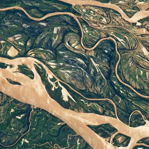
The Paraná Delta is a large area of 22.587 km2, and it is defined as a complex model of estuarine Delta (Parker & Marcolini, 1992). It is formed by alluvial sediments transported and allocated by the Paraná River. As it is highly dynamic, there is a continuous growth with approximately 2.37 km2/ year (Codignotto & Medina, 2011).
The Parana Delta can be defined as a complex system, where two open, uncertain and dynamic systems converge and interact , the biophysical processes and climatic conditions and the metropolitan dynamics (Zagare, 2018).
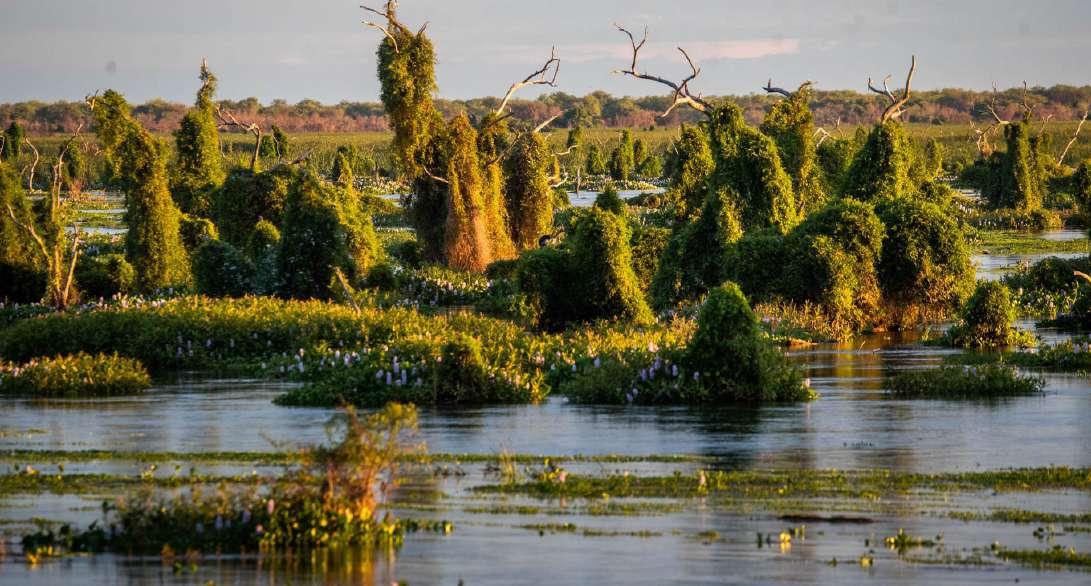
The importance of The Paraná Delta lies strongly in the sedimentation processes that support Wetlands and which enhance the adaptive capacity of the Delta facing climate change. Wetlands in The Parana River basin are macro-system given their extension and complexity (Neiff, 1984). There are multiple landscape units and ecosystem services that fulfill functions of great importance for the entire region.
The last decades, the Deltaic Region has suffered radical changes as a consequence of anthropogenic activities, which have disrupted natural processes and the landscape. As the result of the multiple pressures upon the wetlands, the biodiversity and ecosystem services continue declining.
Even with the negative effects of anthropogenic action upon the wetlands, the region continues to exhibit a good conservation status and provision of many ecosystem services. But only one percent has effective conservation strategies, national parks and private management (Kandus, 2016).
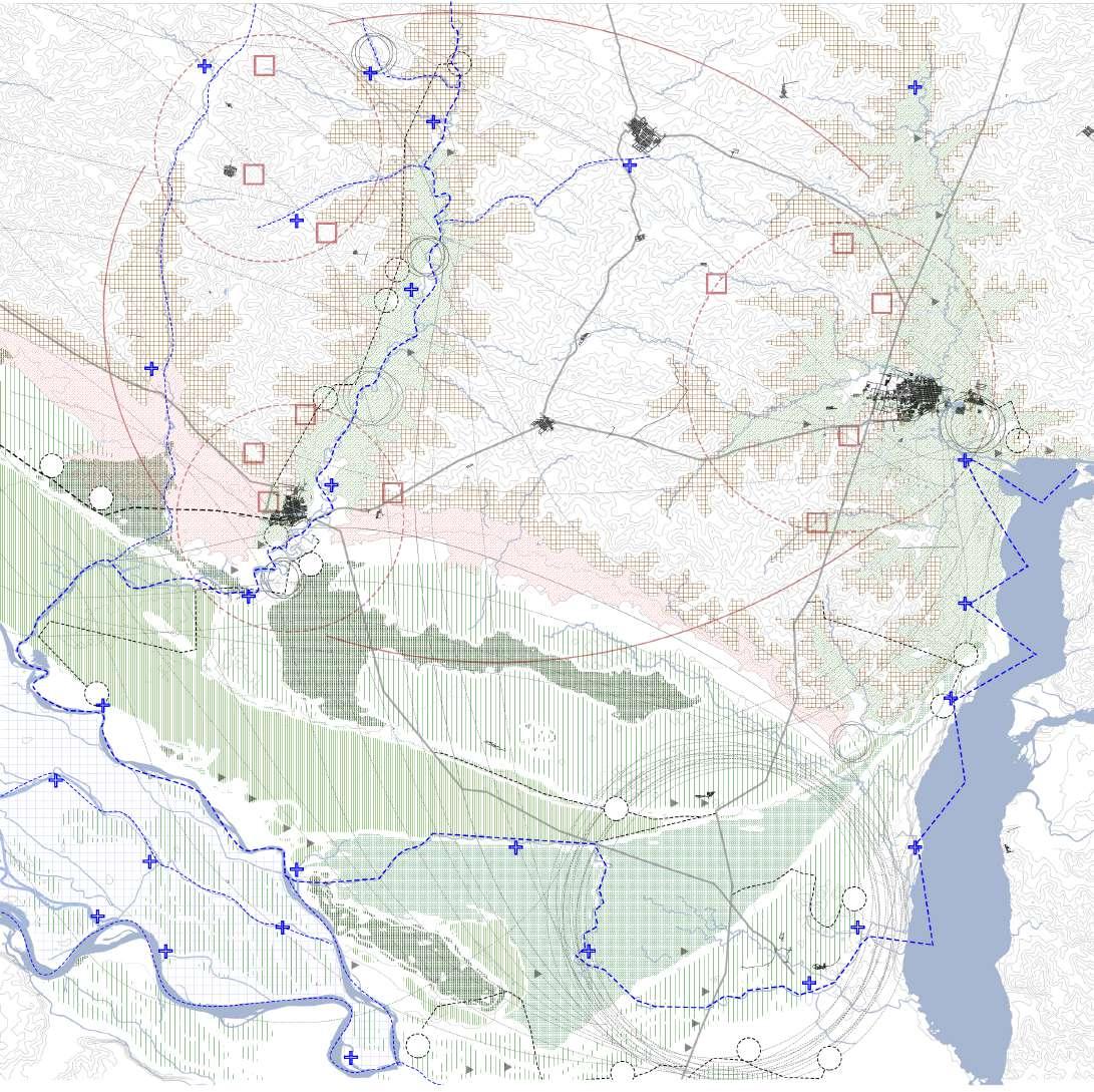
Political borders
Sub river basin borders
Aquifers
Mosaic of Wetlands
Urbanization
Hydropower plants
The economic benefit and profits are the definition of the wetlands for many governments, and land owners. The Paraná deltaic region has faced the transformation of the landscape for economic profit.
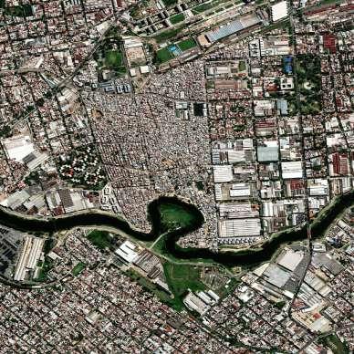
The metropolitan areas that have expanded upon the wetlands such as the city of Buenos Aires, the landscape and the aesthetic characteristics of the wetlands attracted private capitals which have developed gated communities since the ‘90s and are in continuous growth. This has radically changed the natural landscape conditions, disrupting hydrologic systems by modifying the topography, elevating the plots to protect the new real estate projects from the natural floodings that characterize the different and seasonal precipitation and river pulses of the Deltaic Region.
The strategic location of the Delta as part of a trade network has triggered, since the colonization times, that much urbanization settled in the riverine, followed by many industrial, port and harbor activities;configuring the metropolitan region between the cities of Santa Fe, Rosario and Buenos Aires. This has caused the loss of soil porosity, which increases the flood risk in these areas.
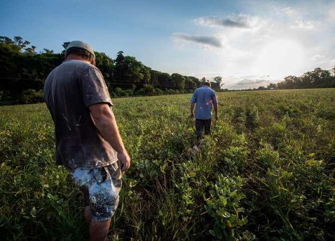
The natural and fertile condition as well as the biodiversity that characterize the Wetlands, has been the reason for the great change of land use in the last decades for the expansion of the agropecuary system frontiers. From the local extraction and use of deltaic resources for subsistence to an intense and extensive extractivism attached to global demands. This has been the main force of change. The exogenous agricultural practices, imitating dryland ones, by modifying hydrological systems and contributing to contamination, enhanced by the bad management of the phosphate levels of the extensive agriculture.
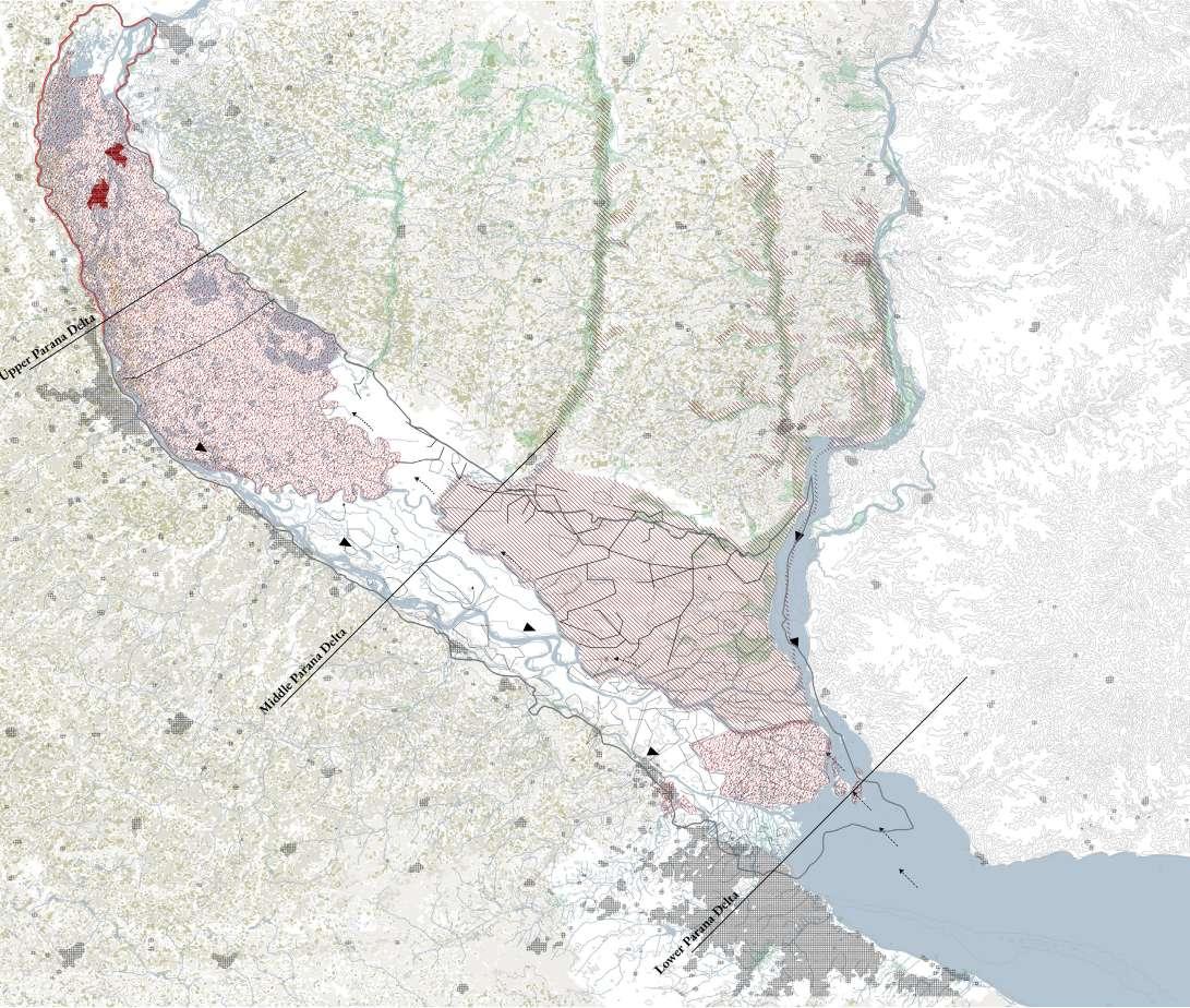
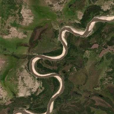
The lower Paraná Delta is defined by many interdependencies of secondary and primary river branches and the confluence with the estuary of La plata River. Streamflow variability primarily affects the Lower Delta and is mainly influenced by the Rio de la Plata and by the climatic events such as the “Sudestada”, which consists of persistent South-eastern winds coming from the Atlantic Ocean. Those drivers may accelerate trends in land use change, including extensive conversion to commercial forestry, livestock production and, less frequently, to agricultural uses with extended biodiversity alteration and loss.
Here are visible two different scenarios in the western and eastern side. On the one hand the western side is characterized by the metropolitan area of Buenos Aires, with the growing conurbation expanded into the wetlands and agricultural and forestry activities. On the other hand the eastern area where there are less pressures related to urbanization, and where natural conditions are still present, sedimentation and water streams continue to exhibit the natural form and flow, stating that more ecological values and opportunities to study and expand these conditions.
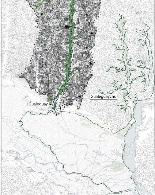
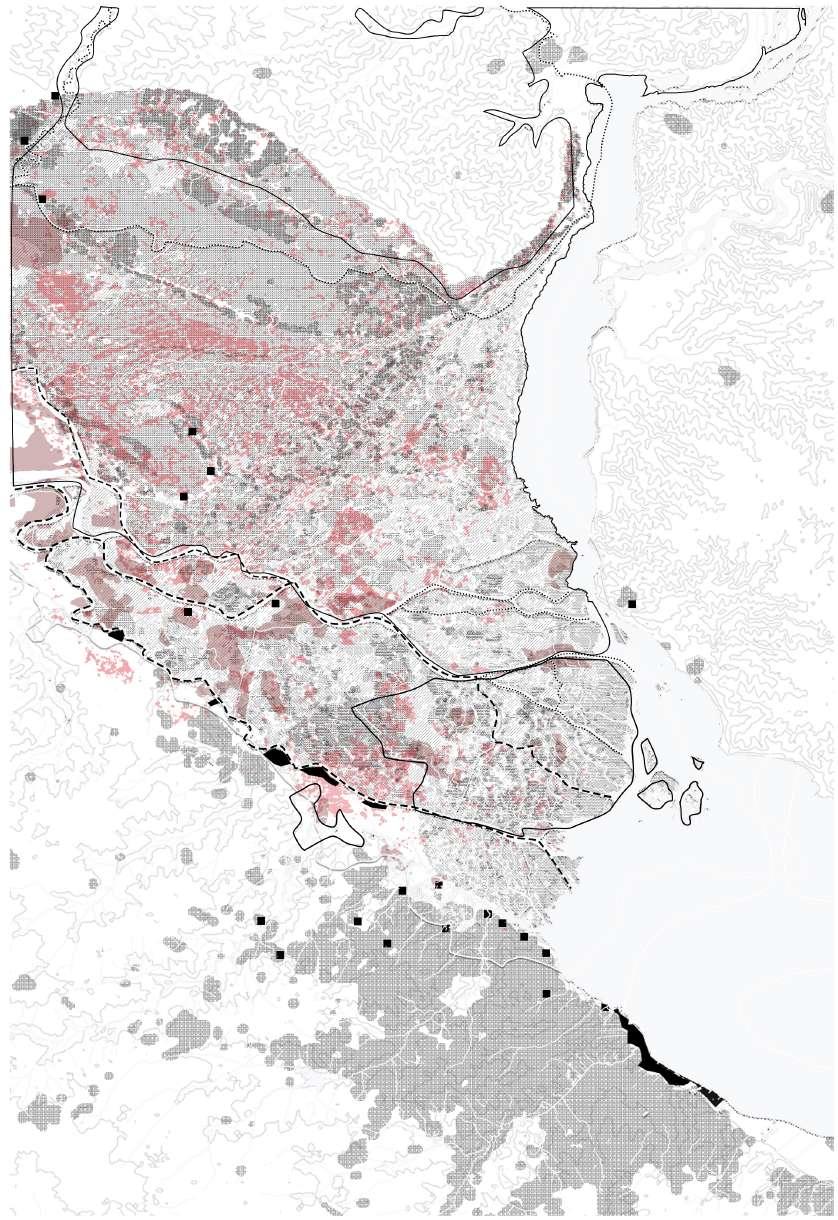
The area of study is the natural reserve “ Los Pájaros y sus Pueblos Libres”, located at the south of the province of Entre Ríos. This area covers two secondary river branches that contribute to the Delta. The average densification goes from fourty to ninety thousand inhabitants per km2 in the bigger cities.
The Natural reserve is a unique community-led conservation initiative in the Gualeguay River floodplain. This initiative aims to protect and conserve the biodiversity of the floodplain while also promoting sustainable development for the local communities.
The Bird Reserve is a protected area that covers about 20,000 hectares of the floodplain, and is home to a wide variety of bird species, including migratory birds that use the area as a stopover during their annual migrations. The
reserve is managed by a group of local residents, known as the “Pueblos Libres”, who have formed a cooperative to oversee the conservation and management of the reserve.
The Pueblos Libres are a group of rural communities that live on the floodplain and have traditionally relied on the natural resources of the area for their livelihoods. The communities have organized themselves to take an active role in the management of the reserve and to promote sustainable development in the region. They have implemented a number of conservation and development projects, such as reforestation, sustainable agriculture, and ecotourism, to protect the natural resources of the floodplain while also improving the livelihoods of the local communities.
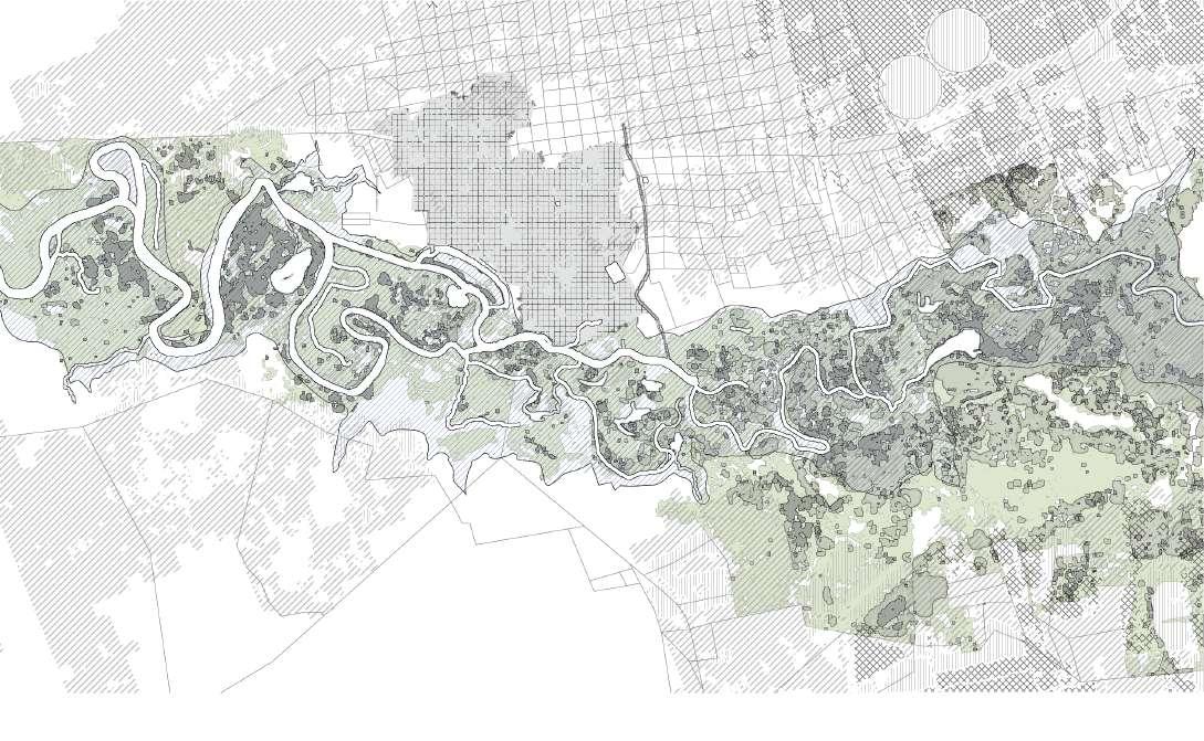
The Western side of the delta is defined by the metropolitan region that includes Buenos Aires Metropolitan area, Gran Rosario and Santa Fe. Here, a third of Argentina’s population is concentrated, as well as the main economic center, a strong agricultural sector, and a growing manufacturing and service sector. Many cities in the region have experienced rapid population growth in recent years, driven by the development of the delta region as a center of industry, commerce and tourism.
Over time, these cities grew and expanded along the banks of the main Parana River, second branches such as the Riachuelo (Buenos Aires) and nearby rivers, because of the provision of freshwater, as well as a means of transportation and trade. However, the rivers also became a source of pollution and health problems, and cause an increased flood risk, due to the urban occupation on the floodplains. The disrupted natural floodplains show the loss of the absorption capacity during the periods of high precipitations and water flows. These developments not

only have caused damage to property, infrastructure and have put peoples lives at risk, but have also caused the total loss of many ecosystems of the floodplain.
The natural reserve “Los Pájaros y sus pueblos libres” is a natural area that covers about 20,000 hectares of floodplain along the Gualeguay river. It is home to a variety of fluvial forests, birds and fish species. This reserve is in the process of becoming recognized as a RAMSAR site.
This side of the Parana Delta, with less urban pressures, still conserves space for the river dynamics and good state of the wetlands along the Gualeguay floodplain. The conservation of this healthy natural area is vital for the livelihood of the local communities as well as its role as a contributor as a river branch of the Parana Delta.
However, the main pressures present in this river are related to the expansion and extensive agricultural practices, such as the soy, corn and weed crops and the rising amount of livestock. These practices have increased after the economic crisis of 2001, where the market and trade became more global and export oriented, increasing the food demands and also the technology used to optimize
and improve the efficiency of crop yield. However, a lack of land use management and policies that set limits and regulate these activities, has led to water pollution, soil degradation and the decline of ecoservices in the wetlands.
The qualities of this conservation area are an opportunity to revise the management of the RAMSAR sites, that tend to be constrained, and propose a more flexible and integrative planning and co-management that considers the approach of Nature Based Solutions as well as to expand the adaptive capacity through conservation towards the Delta region.
The Paraná Delta is a rich natural area with multiple complex and dynamic landscape units, formed by particular sedimentation and accumulation processes, characterized by specific flora and fauna. These landscape units evolve and are transformed by the hydrologic dynamics and climatic events that defined the deltaic region.
Historically, these deltaic conditions and qualities, such as the strategic location connecting South America with the world, as well as the performance of the natural environment for productive purposes, have been of great attraction for urban occupation; one third of the Argentinian population is allocated along the Paraná Delta. The disconnected relation established between humans and their environment has triggered enormous changes in the natural and ecological state of the wetlands, and in the last decades has been accelerated by the effects of climate change.
Regional trends show an increase in precipitation levels and temperatures in the upper and middle delta, as well as extreme hydrological events. This, in combination with traditional practices of biomass burning to increase agriculture production, are spawning negative effects such as soil degradation, changes in vegetation and loss of fauna (Kandus et al., 2009).
The lack of a long-term vision for the region, caused by the complex network of relations and management, combined with the expansion of the extensive mono-agricultural system and urban development, is reaching a breaking point of no return. Wetlands have tangible and intangible ecosystemic values, but many of the ecosystem functions and services are not recognized by society (Blanco, 2010).
Although there are areas recognized and protected by different parties and intergovernmental treaties, such as the RAMSAR convention, they are fragmented, work without an evolutionary approach and without a real
integration and strategy for a wise use of wetlands and management that contemplates different actors and local strategies.
The space used for productive purposes, the resources management, the urban development and the infrastructure that The Parana Delta contains to fulfill global demands, is moving away from an ecohydrological approach (Baigun & Kandus, 2008) and displaced any local interest, transforming it from a natural corridor into a purely economic corridor.
It is possible to have a more equal and self-regulating interaction between ecosystem services and human well-being when people have a direct relation with their environment.
In reality, human well-being is fully connected with the capacity of the environment to deliver these ecoservices, and it depends on the state of the environment and consumption patterns in ways that reduce or increase the supply of these ecosystem services (Hefny et al., 2005)
The natural reserve “Los Pájaros y sus Pueblos Libres” exhibits high potential in terms of ecosystem services present in the region but specifically in the floodplains; the backbone of this natural reserve. However, the possibilities to rethink the connection between local people and natural capital need a reinforcement by using the qualities that exist in place, through a local strategic management that ensures an equilibrium between human and ecoservices.
Starting from the floodplains, as the critical biophysical unit in which wetlands are present and focusing on the pressures that constrain their ecological values, expanding its capacities and qualities to the Delta, and, finally, to the river basin.
The development model of South America, strongly linked to global demands, has shaped the relation human-nature by establishing economic values over natural values. This is particularly visible in the Parana Delta, where tensions are rising between urbanizations and natural functions.
The Paraná Delta is the result of multiple natural dynamics, characterized by a large economic potential as well as valuable ecosystem services; the wetlands. Fueled by the dissociation between human well-being and the local ecosystems, the wetlands have been rapidly modified over the past decades, mostly due to overexploitation of land, spatial pressures from urbanizations and lack of a cross-scale integral management. The increasing pressures and interventions in the River Basin are affecting the sedimentation natural processes, the fundamental basis for the existence of wetlands.
The environmental adaptive capacity of wetlands lies in its sedimentation processes, the conservation of its ecoservices and its continuous formation. Influencing the adaptive capacity of wetlands has direct consequences for the biophysical dynamics and the built environment in the delta.
Considering the global problem of climate change and the opportunities and values the wetlands of the Paraná Delta possess, the current imbalance is a missed opportunity in the search towards deceleration of nature’s demise and a healthy human-nature equilibrium.
Where the link between ecosystem services and human well-being is clear and immediate, affected people are more likely to develop regulatory institutions to ensure the continued supply of services
Hefny
et al. (2005)Considering the global demands and the rapid land use change, driven by the productive and economic development that has and is continuously transforming the Deltaic Region of the Parana Delta the last decades, the goal of the thesis is to encompass forces by linking different local systems and actors. Starting from the local scale, the natural reserve “Los Pájaros y sus Pueblos Libres”, which I consider to be a realistic scale of transformation, creating a strategic planning framework, and explore to what extent this different management and co-management, with an approach that integrates vernacular knowledge and strategies, can expand the integration of values that the natural reserve has towards the society. It is an exploration that conceives strategies of conservation with a systemic and integrative approach that proposes a new linkage between human well-being and ecosystems.
Taking into consideration the actual and future climate change effects and the influence in the current development of the deltaic region, it is vital to strategically plan and counteract the anthropic actions and the continued exhaustion of the land and natural resources. The exploration considers the importance of the management framework of the RAMSAR sites, but expands on the local specificities and the interrelation among different scales; the natural reserve LPPL, the Parana delta and La Plata river basin, scales that confluence in the wetlands. Increasing the adaptive capacity based on a local and sensitive perspective towards the immediate environment. This can be achieved by revealing the potential of the natural capital, as well as the environmental, socio-cultural identitarian values that are in place, which understand life and natural cycles
The natural reserve Los Pájaros y sus Pueblos Libres as a sub-unit of study, that considers one relation between river contributors of the Delta. This natural area has less pressures coming from the metropolitan area and still presents high ecological values, provided by the ecoservices in place, as well as potential for a future sustainable development. The goal is to analyze and assess the systemic interdependencies between productive practices and floodplains, reveal the potentialities, limits and capacities, explore the wetlands to a minimum supportive local system, examine how it can be transformed and maximize the potentialities by adding other regions. I envision a plan with a broader set of actors, reactivating the local agents, with different functionalities and strategies which can be expanded towards regional actors, bringing the changes from a local scale to larger scales. By implementing Nature Based Solutions strategies that aim to have an equilibrium and integration of natural and urban dynamics linked to soil, water, environmental, land use and local management. These characteristics will set up a system of care, where the transformation is thoughtful and careful, and which forms the backbone that assures persistence and monitoring of overtime.
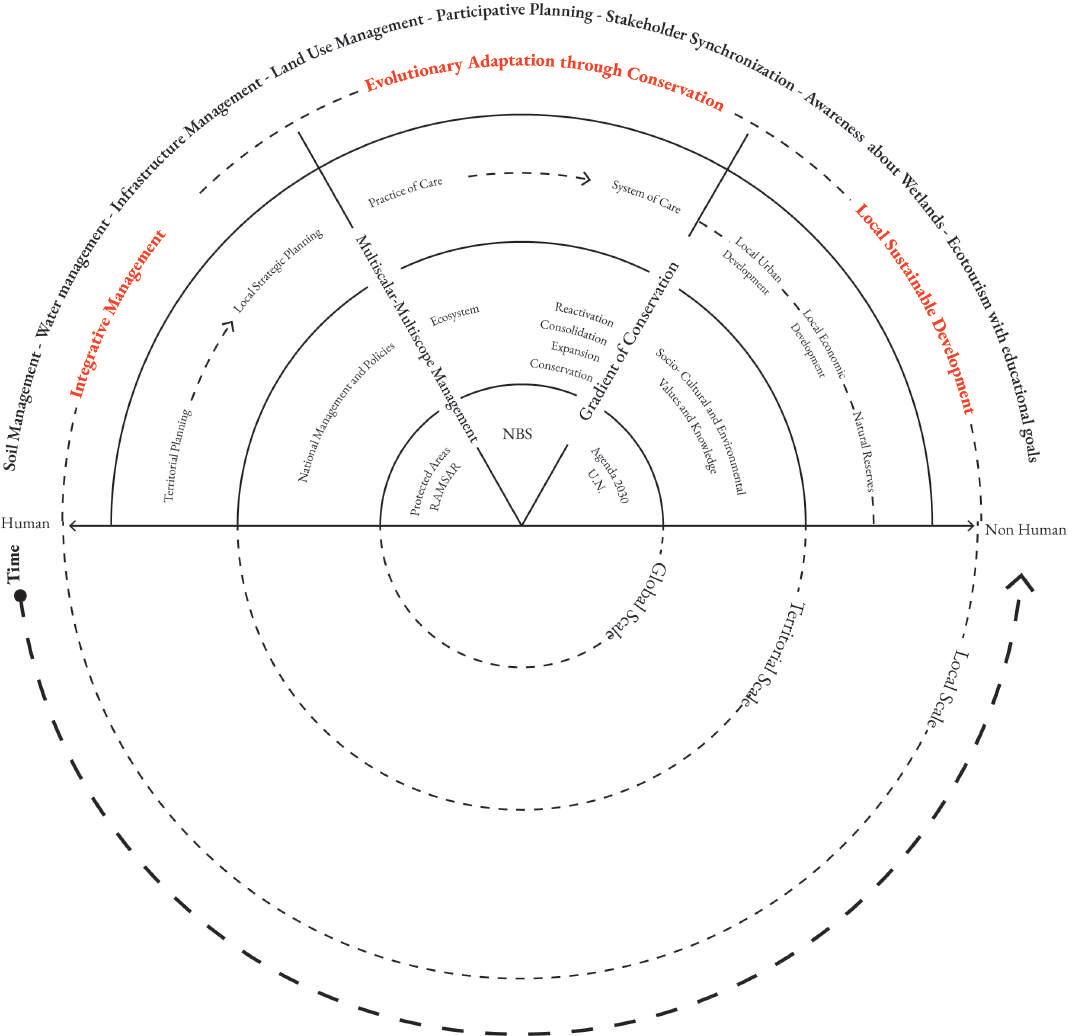
First of all, it is important to understand and revise the agenda 2030 from the U.N. for a sustainable development, the management of RAMSAR sites, and Nature Based Solutions. From there, this thesis will explore ecosystem approaches, and the reactivation, consolidation, expansion and finally conservation, including socio-cultural and environmental values, of the case study. Then, start working from territorial planning towards a strategic planning framework and from the practices of care to a system of care for a more local urban economic development and a local management of the natural reserve. In order to set up an integrative local management, and an evolutionary adaptation through conservation for a local sustainable development. These include variables such as soil-, water-, and land use management, participative planning, stakeholder synchronization, promotion of the awareness about the wetlands and reinforcing ecotourism with educational goals and immersive interaction. Finally, with a multiscalar management and gradient of conservation strategies in the different scales.
From the design of the management system, which sets specific regulations and rules, in time promotes and allows an evolutionary adaptation through conservation, based on a system of care in the different scales and that operates in the different subsystems in order to reach a sustainable development that considers nature based solutions as the strategies that integrate social and natural challenges.
Main research question
How to counteract the anthropogenic disruption upon the wetlands, taking the natural reserve Los Pájaros y sus Pueblos Libres as a biophysical unit of design and expand the adaptive capacity of its system and stakeholders within the delta dynamics?
Sub questions
SQA1
What is the current adaptive environmental capacity of the Lower Paraná Delta?
SQA2
What are the current visions and policies related to the development of the LPD and who are the main actors involved?
SQA3
What are the main elements of the economy of the LPD, how has it developed and what is the outlook for its future?
SQA4
What are the socio-cultural characteristics of the LPD that need to be conserved?
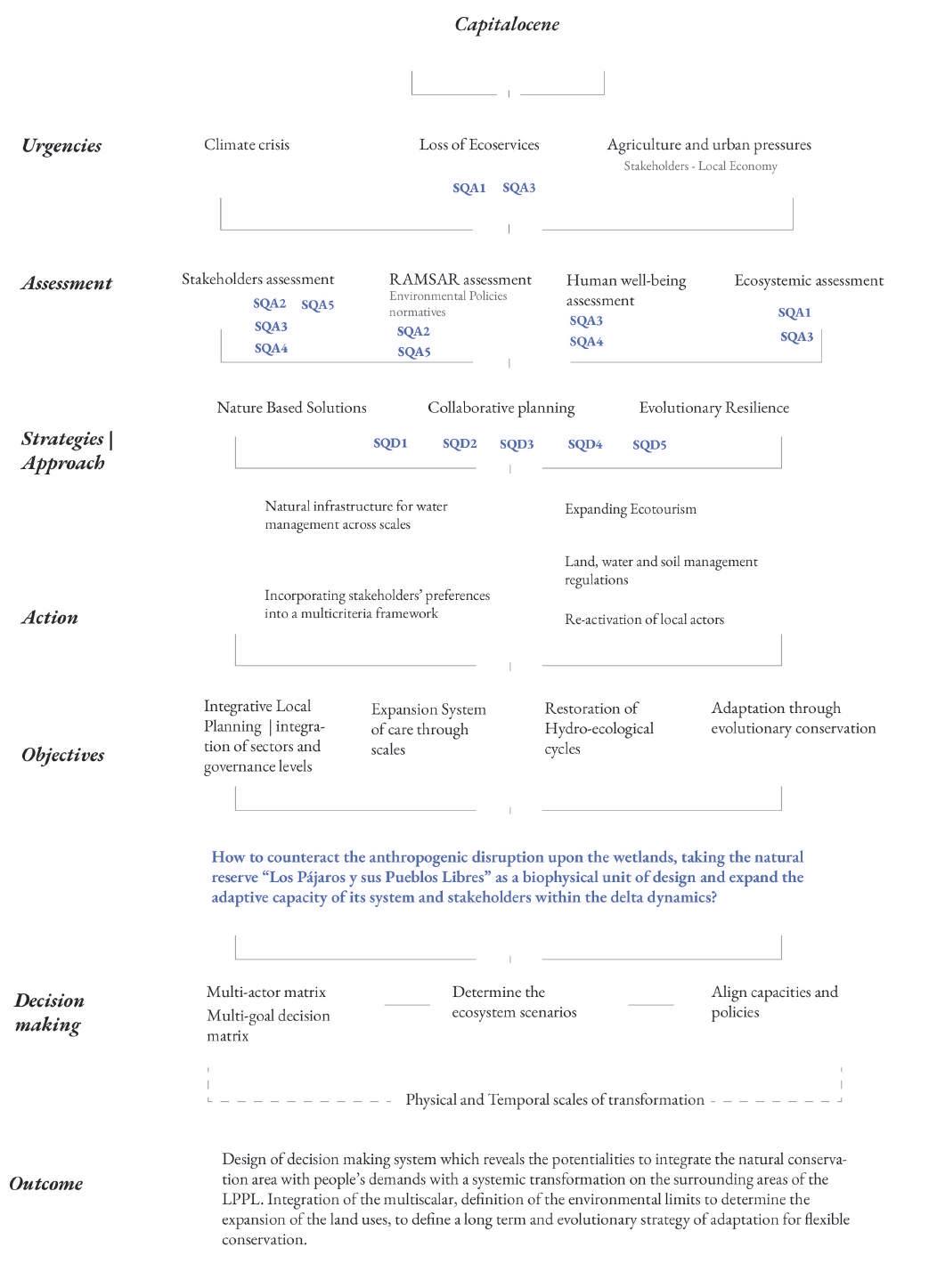
SQA5
How to make wise use and development of wetlands?
SQD1
How to improve the adaptive capacity of the Lower Parana Delta?
SQD2
What are the main elements for sustainable development in deltaic zones?
SQD3
How to preserve and expand the existing ecoservices in the LPD?
SQD4
Which strategies could be implemented to enhance the local management for a sustainable development?
SQD5
How to engage and articulate multiple actors for sustainable development in the LPD?
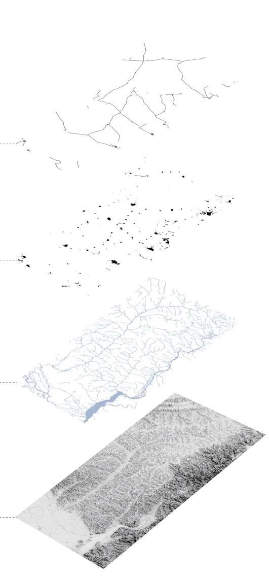
Sedimentation as the supportive system of the deltaic region
Transitional Territories studio proposes a methodology of analysis to go deep and explore different aspects and relations between different systems, that explain the current situation, the limits and influence in the environment. The focus of this approach is Matter, Topos, Habitat and Geopolitics.
Matter
Soil + Water + Air
Topos
Terraforming + Occupation + Disruption
Habitat
Intrusion + erasure + Soil degradation
Geopolitics
Water + Operational Landscape + Energy
The sediments are the main substance of the deltas. The sedimentation processes are influenced by climatic and geological conditions and vegetation. The health of the delta relies on the amount and type of sediments that are deposited in the river mouth.
The map demonstrates the critical areas with different levels of erosion (in purple). Excessive risk of erosion in the Bermejo and Pilcomayo part of the Medio-bajo Paraguay River basin generates sediments for channeled erosion. In these areas predominate high slopes and high levels of precipitation, accompanied by other factors like the land use for megamines and extensive deforestation.
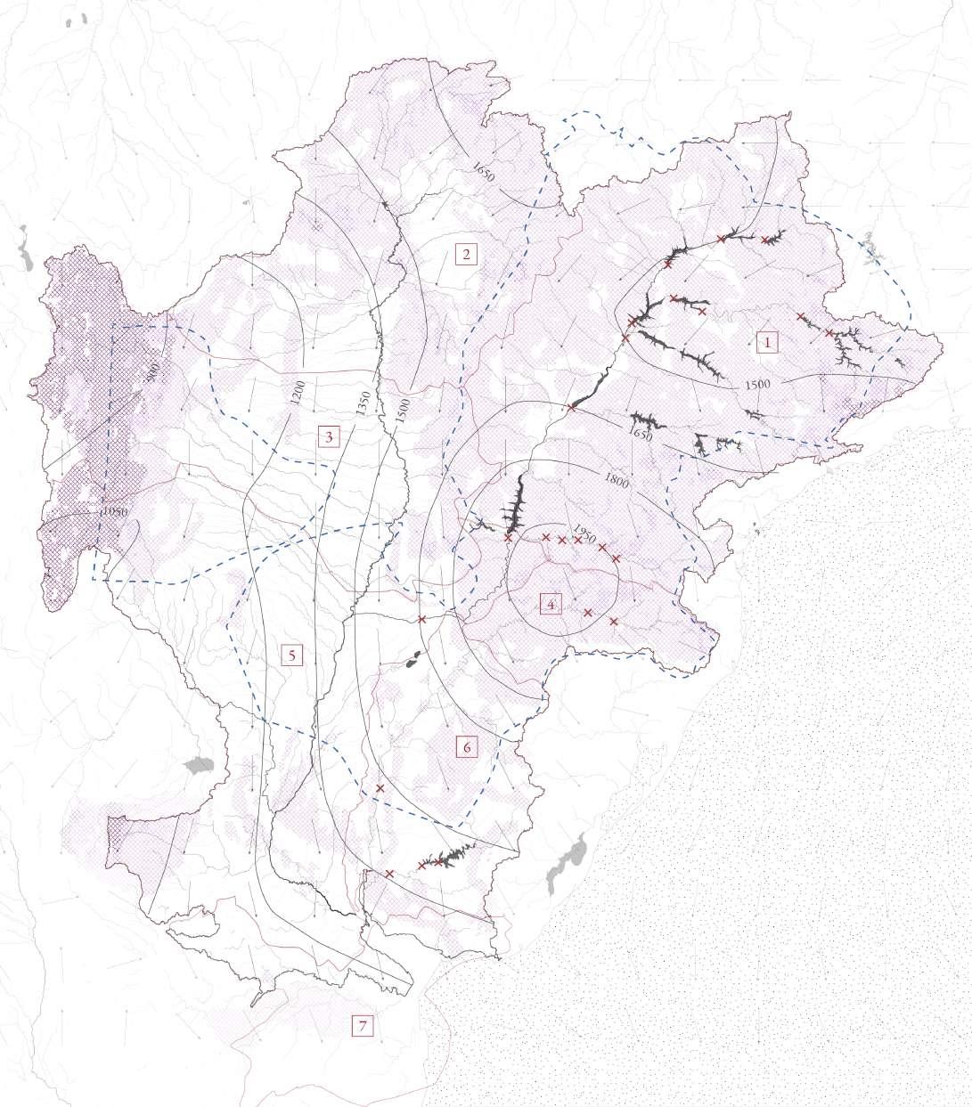
Sediment transportation is also affected by the hydropower plants allocated in the upper eastern side of the La Plata River Basin. Brazil and Paraguay rely on the electricity produced in this river basin.
This process of degradation is responsible for the total loss of the productive and ecological capacity of soils in the short and long term.
Atlantic sea
Aquifers
Water flow
Reservoirs
Annual Precipitations lines
Wind flow
Hydropower plants
Medium Erosion
Intense Erosion
Excessive Erosion
Watershed
Alto Paraná
Alto Paraguay
Medio y bajo Paraguay
Alto Uruguay
Medio y bajo Paraná
Bajo Uruguay
Río de la Plata
Wetlands are characterized by saturated soil and waterlogged condition, making them home to a diverse array of plants and animal species such as migratory birds, amphibians and fish. In 15 years, grasslands have increased by 35,3% in surface for grazing animals, while freshwater marshes decreased by 41,5% in the lower Parana Delta (Quintana et al., 2016)
When grasslands encroach upon wetlands, the effects can be wide-ranging and severe. One of the most significant impacts is the loss of wetland habitat for native species. Grassland encroachment on wetlands can also lead to increased sedimentation. As the grasses take over, they can contribute to the erosion of the wetland. This can lead to increased sedimentation, which can smother wetland plants and animals, making it difficult for them to survive.
Legend
Fresh water marshces
Grassland
Cavean forest
Popular Plantation
Crita galli forest
Willow Plantation
Land cover change 2000-2015 from native forest to Grassland
Areas affected by the fires 2020
Urbanization
Water
Port areas
Industry
Protected areas
Main transport routes
Main touristic routes
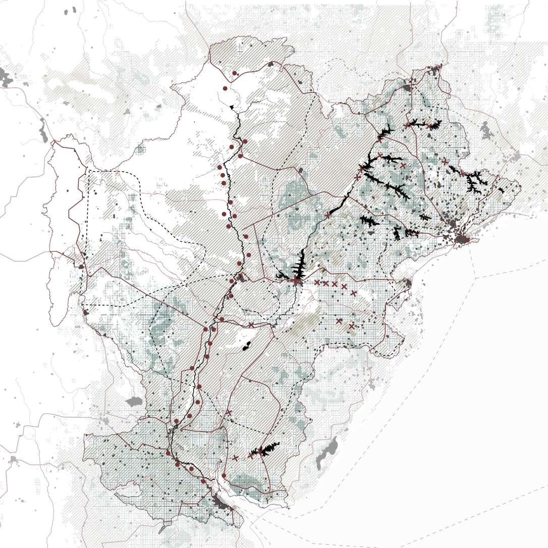
The La Plata river basin covers part of Argentina, Brazil, Paraguay and Uruguay, and it is home to over 60 million people. There is an overlap of interests due to its importance as a source for freshwater and energy and its role as a logistic network for transportation of goods for the whole region.
Historically, the La Plata river was an important means of transportation for the region. The river was used to transport goods and people, and it played a significant role in the development of the region’s economy.
The sedimentation of the river, which has caused the river to become shallower and more difficult to navigate, has been one of the drivers that create a cross border plan for “Hidrovia”, a large-scale waterway development project that improves the navigability and transportation across the region. The project has been ongoing since the 80s and has faced significant challenges, including disagreements over funding, management among the participating countries and environmental dilemmas. The dredging of the main channels will increase the water flow, which can lead to erosion of the riverbanks and the sediments transportation downstream and affect the formation and stability of deltaic systems.
The nexus of water-energy, there are many hydropower plants along La Plata River basin, where primarily Brazil and Paraguay rely on the energy produced in Itaipu and Yasireta plants. However, these have had consequences on the freshwater flows and the breeding and migration patterns of fish and other aquatic species.
Soybeans are a major export crop for the region, with Argentina and Brazil being among the top soybean-producing countries in the world.
Overall, all these pressures have shaped the occupation of the river basin, as well as the over exploitation of resources, causing the detriment of ecological cycles and ecosystems.
Soy crops
Cattle Farming Urbanization
Aquifers
Reservoirs
River Basins borders
Main road connections
Trade water network
Hydropower power plants
Ports and harbours- Hidrovia
Systemic context
Ecosystem-based adaptation using NBS approaches
Design proposal
Landscape values
Design framework
The Parana Delta is comprised of an extensive network of rivers that originate from higher grounds and converge into the Rio de la Plata estuary near Buenos Aires. To be able to grasp the complexity of the Parana Delta and intervene effectively, it is essential to view it as an integrated system composed of interconnected ecosystems that provide a variety of services. Any intervention or disturbance in one area can have direct consequences for the surrounding regions. Negative impacts such as soil pollution and droughts in higher areas can potentially impact the lower lying grounds. Conversely, ecosystem based interventions and conservation efforts in higher levels can have positive cascading effects by ensuring the provision of vital resources such as water, oxygen and sediments downstream.
A notable region within the delta is Los Pajaros y sus Pueblos Libres (LPPL), which is a protected reserve and is in the process of being recognized as a RAMSAR site. Because this region is facing relatively fewer pressures compared to other areas, LPPL continues to provide significant ecosystem services to its surroundings and, downstream, towards the delta.
The Gualeguay river basin, one of the primary contributors to the Parana Delta, forms part of the LPPL area and plays a vital role in influencing the health of the reserve as well as the overall well-being of the delta. The quality of water flowing from the Gualeguay river downwards is a crucial component herein.
Recognizing the systemic context of the Parana Delta emphasizes the need for a holistic and interscalar approach to its management and conservation that encompasses the systemic functionalities of the ecosystems in place.
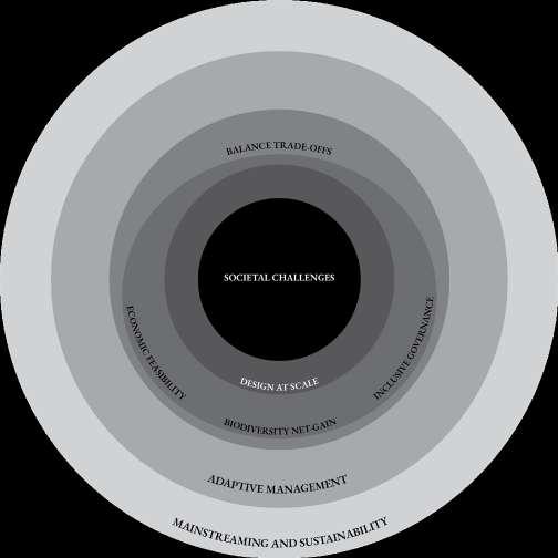
Figure 44 illustrates the central approach adopted for the strategy of change. Ecosystem-Based Adaptation (EBA) assumes an important role in combination with three primary pillars: Ecosystem and biodiversity services, human well-being, and climate change adaptation. EBA entails a nature-based framework aimed at adapting to the impacts of climate change while strengthening the resilience of ecosystems and communities.
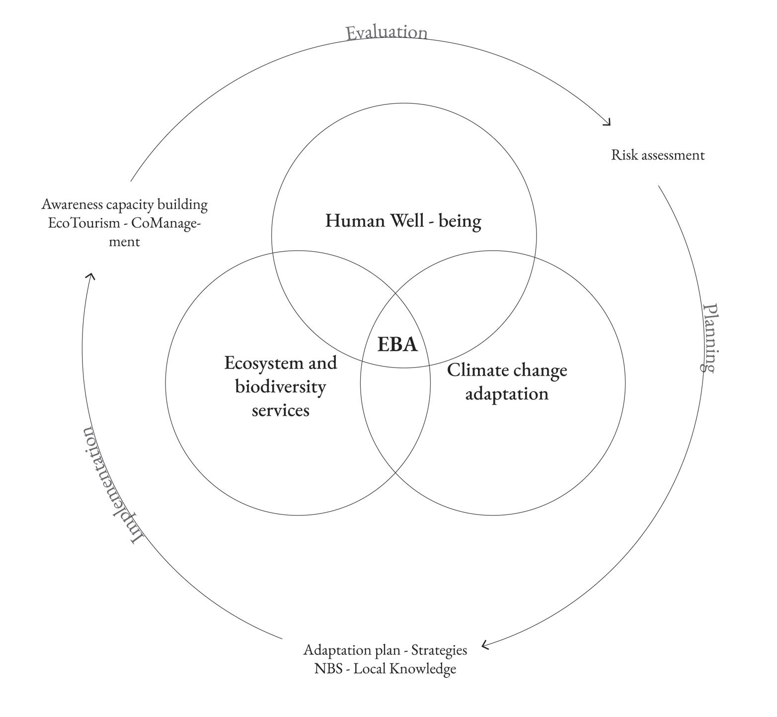
The first pillar, ecosystem and biodiversity services, underscores the significance of conserving and rehabilitating ecosystems. The second pillar, human well-being, acknowledges the importance of addressing social and economic considerations in pursuit of sustainable development. The third pillar, climate change adaptation, recognizes the imperative of implementing measures that reduce vulnerability and enhance resilience to climate change impacts.
The planning process involves formulating an adaptation plan leveraging Nature-Based Solutions (NBS) (Figure 45) that draw upon local knowledge and are inspired and supported by nature. These solutions address societal challenges in a cost-effective and adaptable manner. Local knowledge assumes a critical role in identifying suitable NBS that are socially and culturally acceptable, as well as in ensuring effective implementation and maintenance. Furthermore, NBS will be deployed to enhance, activate, and expand ecosystem services.
The implementation of EBA encompasses diverse strategies, including awareness raising, capacity building, ecotourism, and co-management. Awareness raising entails educating communities about the significance of EBA and facilitating their participation in the implementation process. Capacity building involves fostering the necessary skills and knowledge required for the effective implementation and maintenance of NBS. Ecotourism can offer economic incentives for the conservation and restoration of ecosystems, while co-management entails engaging stakeholders in decision-making processes.
The final step in the EBA process involves evaluation, which incorporates risk assessment. Risk assessment serves as a valuable tool for identifying potential hazards and vulnerabilities, and for prioritizing actions aimed at mitigating risk. Monitoring and evaluating the effectiveness of EBA measures and adapting them as necessary is essential to ensure their continued success.
“Worldwide evidence of escalating human impacts on ecosystems raises questions about their capacity to continue to provide the services necessary for an acceptable level of human well-being”
Figure 46 demonstrates the main backbone of the proposed strategy; a new system of care based on common values.
The triangle represents the different types of ecosystem services as described by McMichael et al. (2005). These have been grouped into three main categories: Provisionary services (P); Regulating and supporting services (R); Cultural, spiritual and recreational services (C). Each of these ecosystem services are a vital part of the ecosystem as a whole and are strongly interdependent. In order to be able to work towards a sustainable future and reach a new system of care, a balance is required between these three main categories. Currently, this system is not in equilibrium and is suffering from a number of pressures and influences.
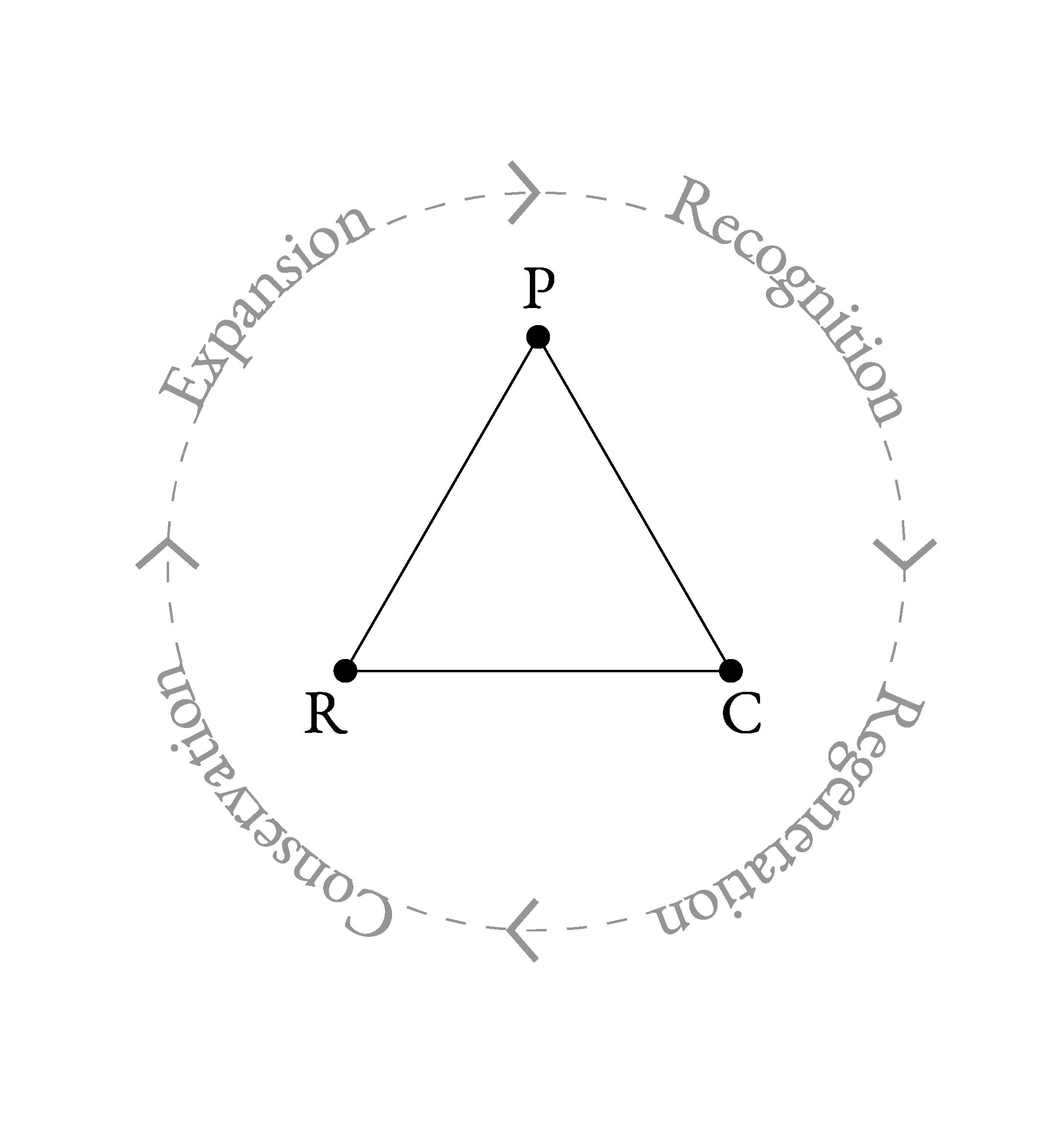
The proposed strategy envisions an evolutionary approach that follows the lines of four consecutive steps: Recognition; Regeneration; Conservation; Expansion
Recognition focuses on acknowledging the importance of the area as a valuable ecosystem and recognizing strategic interventions will need to be done in order to effectuate change.
Regeneration works towards regenerating the area by implementing strategic interventions that restore the natural balance and establish a system of care based on common values.
Conservation builds upon the interventions implemented during regeneration and solidifies them into an institutionalised system of care.
Expansion is the phase in which the institutionalised system of care can be expanded and replicated in new areas, starting again from the recognition phase.
The following chapters will further expand on this strategy and suggest strategic interventions for moving towards a balanced system of care.
R = Regulating and supporting services
C = Cultural, spiritual and recreational services
Based on McMichael et al. (2005)


To address the challenges the Parana Delta is facing and to reinforce its values in a sustainable manner, two main strategies are proposed for an evolutionary transformation of the Parana Delta:
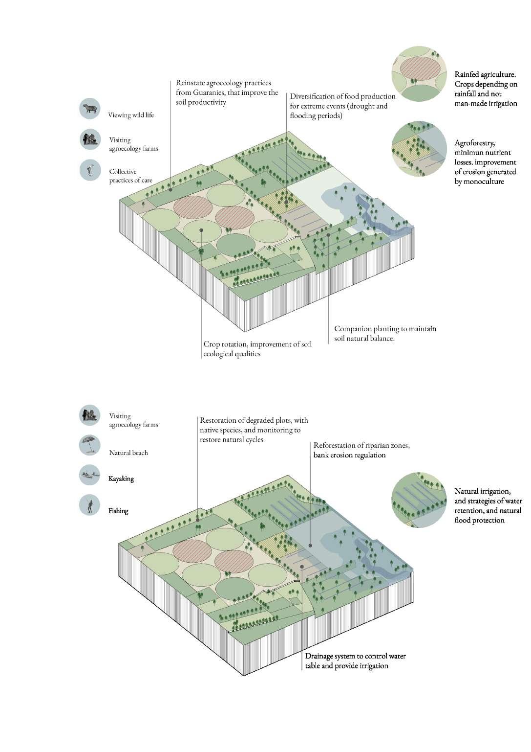
Strategy A presents a comprehensive approach to address the challenges in agriculture and ecosystem management within the Parana Delta. The goal of this strategy is to transition from conventional agricultural practices to an agro-ecological system that ensures long-term sustainability. This includes the adoption of agroforestry, crop rotation, integrated pest management and the reduction of the dependence on synthetic products. This will not only enhance soil fertility, but also contributes to biodiversity conservation and ecosystem health, which in turn will create a resilient agricultural system. Moreover, the strategy emphasises the preservation and restoration of natural ecosystems such as wetlands, forests, and grasslands. Enhancing cultural and regulatory ecosystem services strengthens the region’s resilience to environmental changes, including climate change. Furthermore, promoting agroforestry and sustainable land use establishes linkages between agriculture and natural ecosystems. Finally, the creation of greenways and wildlife corridors improves habitat connectivity, enhances genetic diversity, and leads towards a healthier ecosystem.
Strategy B places significant emphasis on strengthening existing eco-tourism narratives and promoting sustainable eco-tourism as a catalyst for economic growth. The strategy acknowledges the intricate interplay between ecosystem services and endeavors to raise awareness and foster a sustainable economy. Key elements of this strategy involve the development of eco-tourism infrastructure and services, such as nature trails, bird-watching platforms, and eco-lodges. By offering visitors the opportunity to experience the delta’s natural system, these initiatives simultaneously encourage the conservation of natural resources. Equally important is the active involvement of local communities in eco-tourism endeavours, particularly through community-based tourism. This will yield economic benefits while safeguarding cultural heritage. In essence, eco-tourism serves as a means to diversify the economic model of the region and accelerate the adoption of sustainable practices.
The combination of these strategies works towards a future of the delta based on shared values and sustainable principles. Effective stakeholder management is crucial for successful implementation. Subsequent sections will delve into the details of each strategy’s implementation and the proposed stakeholder management approach.
Transforming the agriculture system into an agro-ecology system & strengthening and connecting existing natural ecosystemsReinforcing Provisionary, Regulatory, and Cultural ecosystem services and strengthening the relation between them
Conserving biodiversity over the coming decades may require the use of new types of Protected Areas that have dynamic borders rather then permanence and the integration of Protected Areas into broader landscape management for conservation goals.
Albers (2022)
Strengthening and promoting the eco-tourism narrative, utilizing it as an instigator for awareness and sustainable development and further strengthening the relation between the different ecosystem services.

The wetlands in the Parana Delta exemplify an ecosystem that confers a multitude of advantages to both the natural realm and the human communities present. These wetlands assume a critical role in upholding social security and stability through their function as a natural buffer against natural disasters, their capacity to mitigate the consequences of climate change, and their preservation of essential biological systems that surpass designated thresholds. A comprehensive and holistic approach is imperative to adapt to extreme events and the consequences of climate change, with the wetlands serving as an integral component of this approach.
The wetlands in the Parana Delta possess notable biophysical attributes, functioning as a natural mechanism for water purification and playing a crucial role in regulating the hydrological cycle, as well as mitigating floods and droughts. These wetlands provide a diverse habitat, accommodating a wide array of species, including rare and endangered ones. Additionally, they contribute to reducing greenhouse gas emissions through effective carbon and methane sequestration. From a social standpoint, the wetlands in the Parana Delta are intricately intertwined with the local communities’ culture and livelihoods. There exists a profound connection between the wetlands and the river, and the inhabitants of the region possess an abundance of tacit knowledge concerning the dynamics of the river and effective means of working harmoniously with it.
Furthermore, the relationship between wetlands and social security bears considerable significance. Wetlands play a critical role in mitigating the impacts of natural disasters, such as floods and storms. They act as a natural sponge, absorbing excess water and decelerating its flow during flood events. Consequently, the risk of catastrophic flooding is reduced, leading to the prevention of loss of life and damage to urban settlements. Wetlands also contribute to the preservation of riverbank stability and provide protection against soil erosion.
What is more, these wetlands form an important habitat for a diverse range of flora and fauna, including numerous native species. Wetlands also function as a natural filtration system that effectively capture pollutants and
excessive nutrients. Furthermore, they safeguard the water quality of rivers and streams and play an essential role in regulating the hydrological cycle, which is a critical factor in maintaining ecosystem robustness and preventing the proliferation of invasive species.
The impacts of climate change significantly influence wetlands and the surrounding communities. Escalating temperatures, alterations in precipitation patterns, and the heightened frequency of extreme weather events all impact the well-being and resilience of wetlands. In response, a comprehensive approach is indispensable to adapt to these changes and minimise their repercussions upon both the natural environment and the human communities dependent upon it.
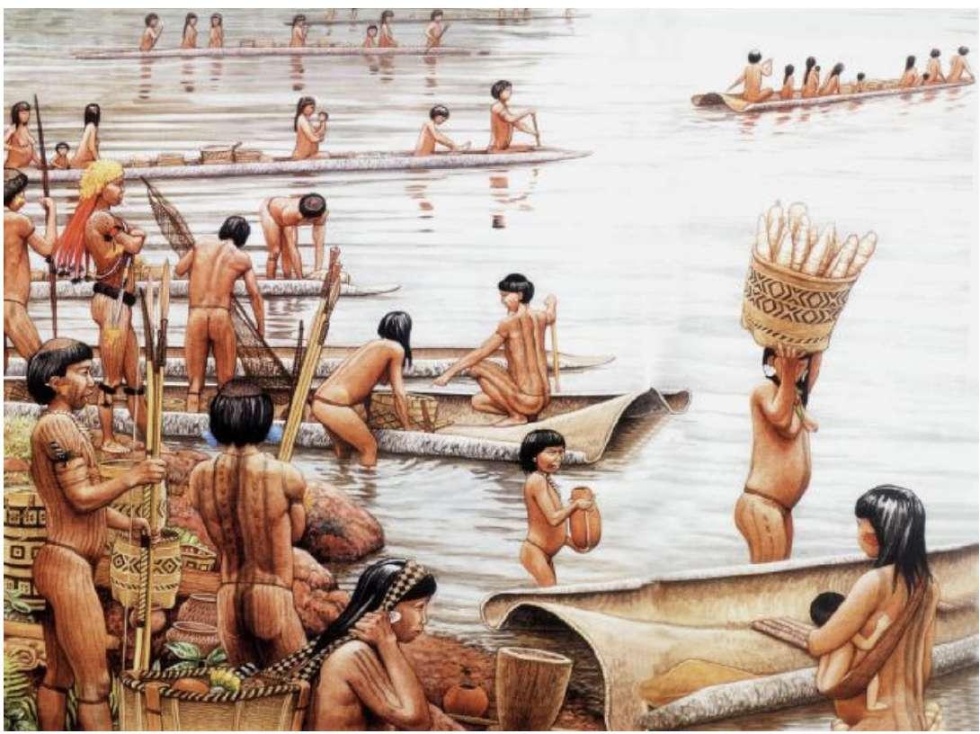
The Guaraní cosmology, rooted in keen observations of the natural environment and cosmic phenomena, underpinned their worldview. In the Guaraní language, ‘Ñande Reko’ encompasses a multifaceted understanding encompassing ontological, systemic and cultural aspects. Fundamental to their perception of a fulfilling existence is the concept of “the land without evil,” which signifies a fertile land overflowing with nutrients that facilitate fruit production and human labour. Land and territory, in the Guaraní perspective, transcend notions of possession, instead representing a communal spatiotemporal entity known as “la Pacha,” wherein a harmonious, enduring equilibrium between humankind and nature is nurtured.
Drawing from their cosmological framework, the Guaraní people embraced agricultural practices that upheld soil fertility through crop rotation. Recognizing the soil as a sacred entity, necessitating periodic respite and vegetative rejuvenation prior to subsequent cultivation, they safeguarded its long-term productivity.
Notably, the Guaraní community maintained an intimate and respectful rapport with animals, deeming them conscious beings with whom they shared the interconnected world. The Guaraní exercised hunting and fishing practices guided by natural cycles. They conscientiously avoided overexploitation of species and refrained from capturing young individuals.
The Guaraní possessed an intricate understanding of river dynamics and exploited their close connection with waterways for transportation, cultural exchanges, and commercial activities. Capitalizing on the river’s flux, they utilised its resources to irrigate crops, constructing terraces along its banks to optimize water utilization while concurrently preserving soil fertility. Additionally, the construction of “cerritos” structures adjacent to the river enabled the Guaraní with diverse advantages and purposes, including flood protection for their dwellings and livestock, facilitation of agricultural practices, provision of observation points, and establishment of ceremonial spaces. Furthermore, the river served as a domain for leisure, relaxation, and recreation (Bonomo, 2012).


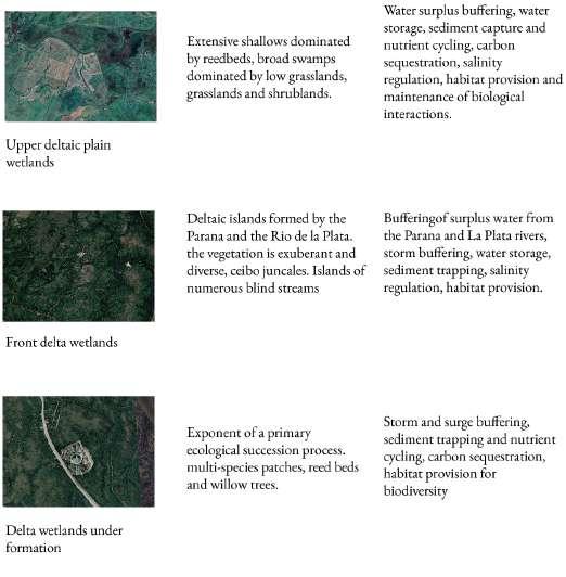
The image presented on the right is a representation of the heterogeneous landscape units and the rich array of flora and fauna species inhabiting the region of the Lower Parana Delta. Each landscape unit possesses distinctive physiognomic characteristics and fulfills unique ecological functions, including beach crest wetlands, which serve as buffers, and front delta wetlands, which regulate salt levels.
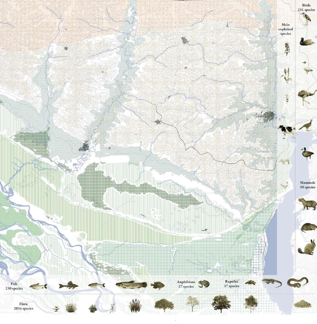
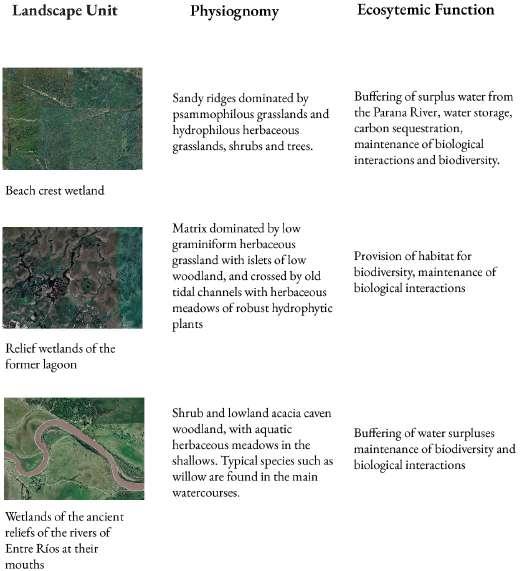
Preserving the integrity of these diverse landscape units is of crucial importance in safeguarding the overall well-being and biodiversity of the region. Environmental degradation and other impending threats can exert substantial repercussions on the delicate ecosystem, affecting the survival of numerous plant and animal species.


The maps on the right showcase the Lower Parana Delta’s agricultural, livestock, and soy cultivation capacities, elucidating the varied land utilization and production dynamics within the region.
The agricultural map highlights the assortment of crops cultivated in the area, such as corn, wheat, and soybeans. Known for its fertility and arable soils, the Lower Parana Delta is a prime location for agricultural production.
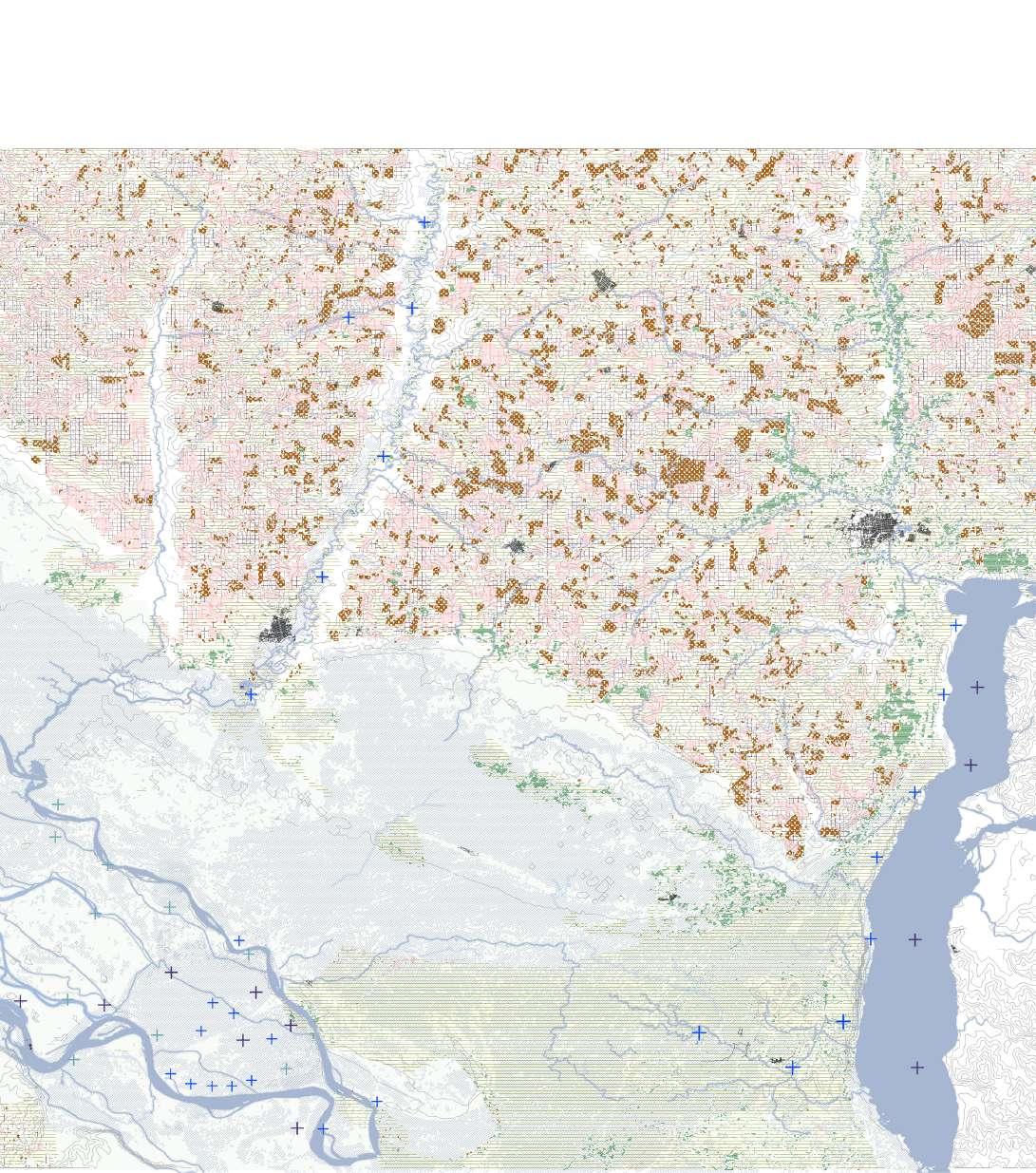

The livestock map portrays the spatial distribution of cattle and other livestock species across the region. Livestock production represents a vital economic activity in the area, providing a source of livelihood for numerous farmers and ranchers, and is a significant commodity for export.
Another significant export commodity is soy. The soy map demarcates the areas dedicated to soybean production within the region. Soy assumes a vital role in the Lower Parana Delta’s agricultural landscape, with numerous farmers relying on its cultivation as a primary source of income.
Collectively, these maps represent the region’s multifaceted and thriving agricultural sector. The Lower Parana Delta’s fertile soils and favourable climate provide ideal conditions for crops and livestock production that sets the region apart from other areas in Argentina.
The Parana Delta is facing a multitude of pressures that threaten the fragile equilibrium of its ecosystems and the well-being of its inhabitants.
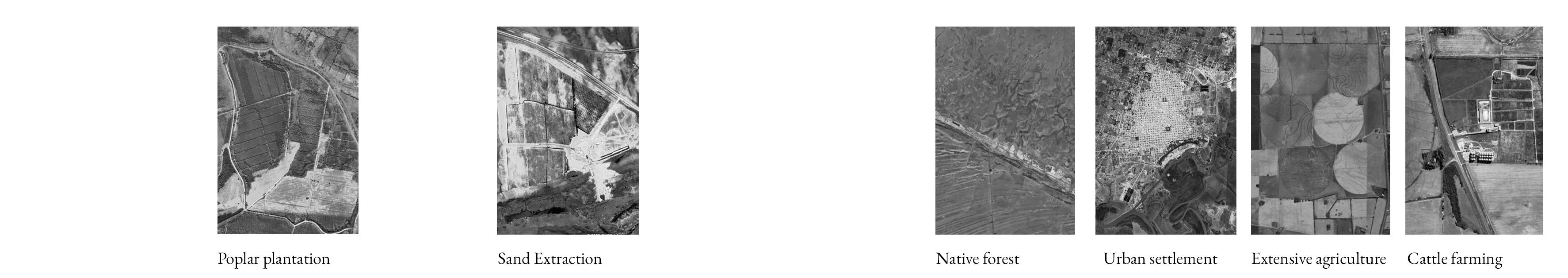
Sand extraction entails the extraction of sand and related materials from riverbeds and coastlines for utilisation in construction, road development, and other industries. This practice is prevalent within the Parana Delta and has caused for considerable shoreline erosion, along with the destruction of habitats for aquatic species.
Intensive cattle farming represents another significant pressure on the delta. The region has traditionally served as a nucleus for livestock production, yet the escalating demand for meat has triggered a rapid expansion of cattle farming. Consequently, overgrazing of pastures, soil degradation, and water contamination from the discharge of animal waste and fertilizers have transpired.
Furthermore, intensive agriculture manifests as a noteworthy stressor upon the Parana Delta. The fertile soils and favorable climate render the region highly conducive to crop cultivation. However, the excessive application of pesticides, herbicides, and fertilizers has caused for soil deterioration and water pollution. What is more, runoff from agricultural fields can foster the proliferation of harmful algal blooms and other aquatic diseases.
Lastly, forestation, or the cultivation of non-native trees for commercial means, has impacted the delta as well. The clearance of indigenous forests to make way for plantation crops can instigate soil erosion and biodiversity loss.
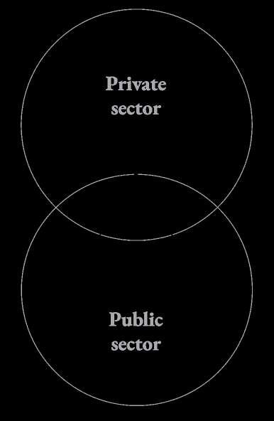
The failure of the private sector to appreciate the intrinsic worth of biophysical values in place, coupled with an emphasis on the exploitation of provisional ecosystem services, has led to distortions within the natural ecosystem ( Figure 66). The alignment between the public and private sectors is inadequate, and has caused for an imbalance in the functionality of ecosystem services.
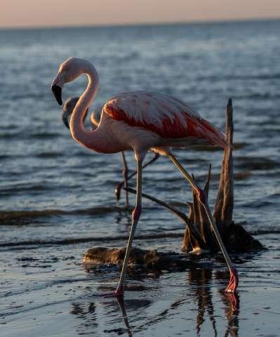
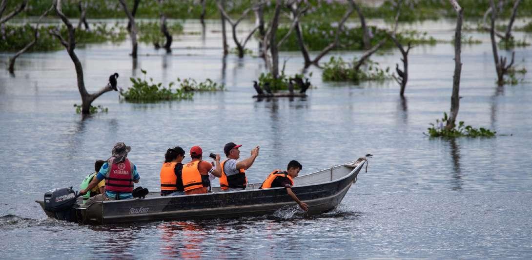
Eco-tourism in the Lower Parana Delta presents a valuable opportunity for visitors to engage with the area’s nature while simultaneously fostering awareness about the significance of ecosystems and conservation endeavors. The Lower Parana Delta, situated in the province of Buenos Aires and Entre Rios, presents an alluring landscape characterized by an intricate combination of waterways, islands, and wetlands. This region of abundant biodiversity sustains a remarkable variety of flora and fauna, encompassing capybaras, caimans, otters, and a diverse avifauna.
Within this geographical context, eco-tourism assumes a vital role in the potential for achieving a heightened synergy between the private and public sectors. Private enterprises can offer an extensive array of eco-tourism endeavors, encompassing activities such as kayaking, birdwatching, and expert-guided nature excursions. In parallel, the public sector can offer valuable contributions to this collaborative endeavor by expediting the establishment of necessary infrastructure, launching promotional campaigns, and instituting regulatory frameworks. Such collaborative initiatives facilitate a more balanced and sustainable development trajectory, where the economic benefits derived from tourism harmonize with conservation undertakings and the preservation of local customs and traditions.

Moreover, eco-tourism assumes a critical role in instigating sustainable development within the area. By promoting ecologically responsible practices, encompassing proper waste management and the utilisation of renewable energy sources, tourism enterprises can serve as exemplars for other industries operating in the region, thereby contributing to a more sustainable future for the Lower Parana Delta and its communities.
Presently, eco-tourism in the Lower Parana Delta lags behind other tourism destinations in Argentina. Nev-
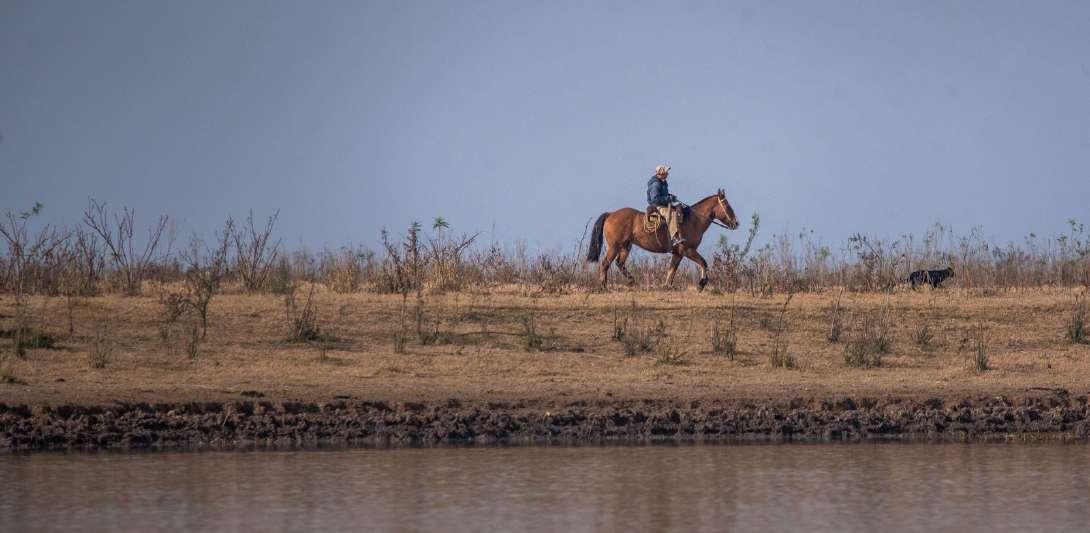
ertheless, the region harbours a rich historical heritage and substantial growth potential, positioning it as a key driver in the region’s development. Boasting a distinctive cultural legacy, including indigenous communities and the gaucho culture, the region is ideal for visitors seeking authentic and culturally immersive experiences, thereby distinguishing itself as a unique selling proposition for eco-tourism in Argentina.
Moreover, the region’s convenient proximity to Buenos Aires facilitates easy accessibility for visitors, and its adjacency to prominent tourist destinations such as the Tigre Delta and the Atlantic coast allows it to integrate seamlessly into a more extensive tourism circuit within the region. By undertaking appropriate infrastructure development and implementing effective promotional strategies, eco-tourism has the potential to emerge as a substantial source of revenue, thus stimulating the economic progress of local communities and playing a vital role in supporting conservation initiatives.
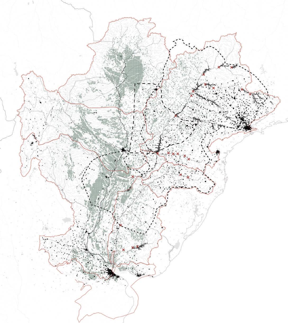
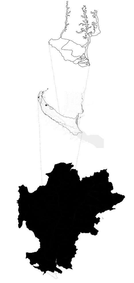
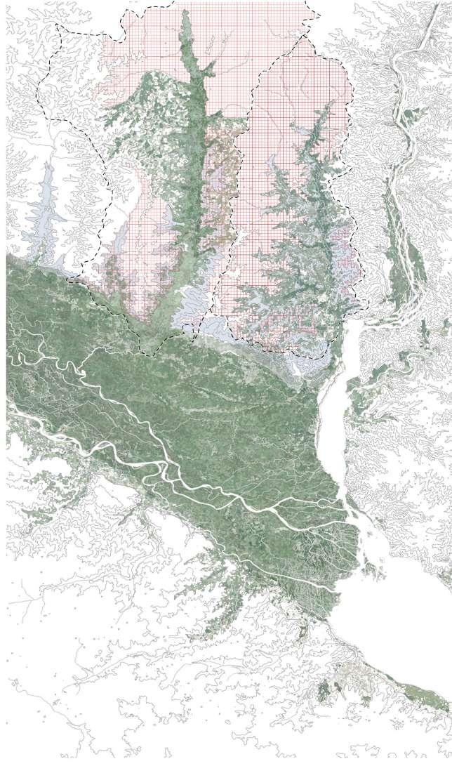
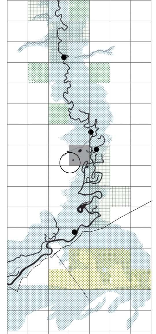
Interrelations between the different scales
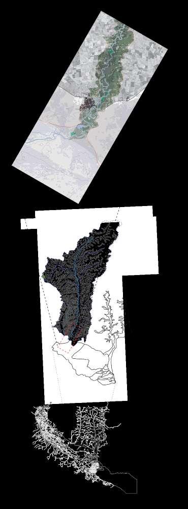
Figure 75 demonstrates the different levels of scale and the relation between them.
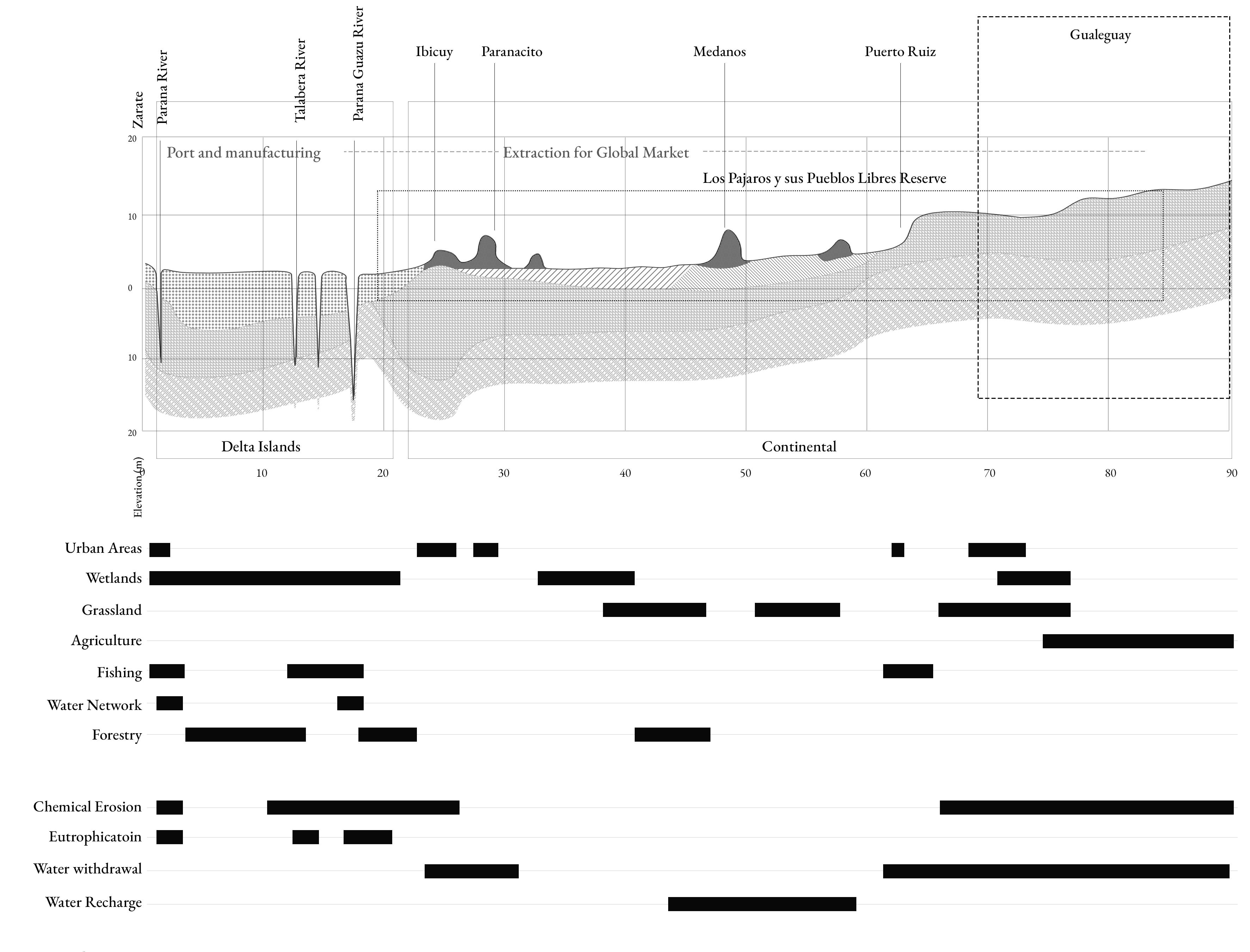
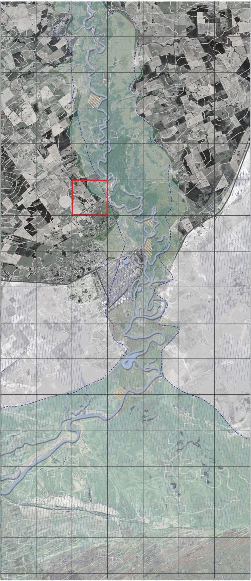
The area of intervention is depicted by the transect at the top of the image. It encompasses the city of Gualeguay and its direct surroundings along the Gualeguay river to the North and South of the city. The transect is part of the tributary ‘Gualeguay Corridor’.
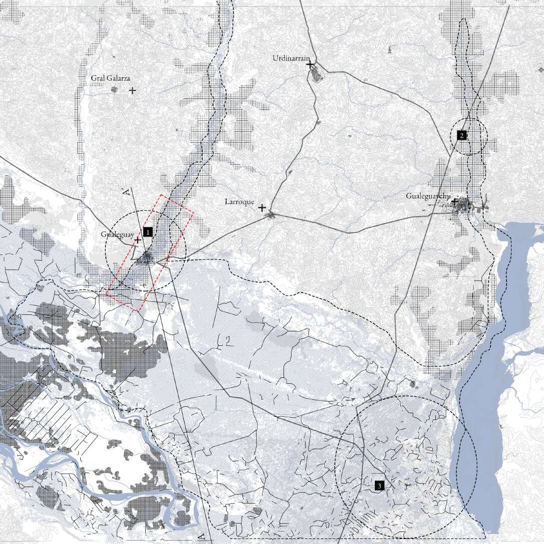
The Gualeguay Corridor is the river bassin of the Gualeguay river and stretches from the hills in the north until it reaches the Parana Delta in the South. As depicted in the image, the Gualeguay river is formed by a variety of contributary branches on both sides.
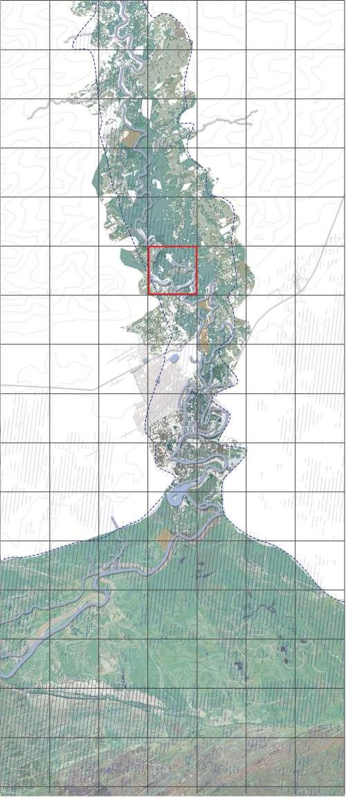
The area ‘Los Pajaros y sus Pueblos Libres’ is a proteced area recognized as such by the RAMSAR. It covers a large part of the Lower Parana Delta, but also reaches North through the Gualeguay river, the Gualeguaychu river and the Uruguay river.
The highest level of scale (bottom) in this sequence is the Lower Parana Delta, the South-Eastern part of the Parana Delta. This is the part of the Parana Delta where all river branches confluence and exit in the La Plata Estuary.
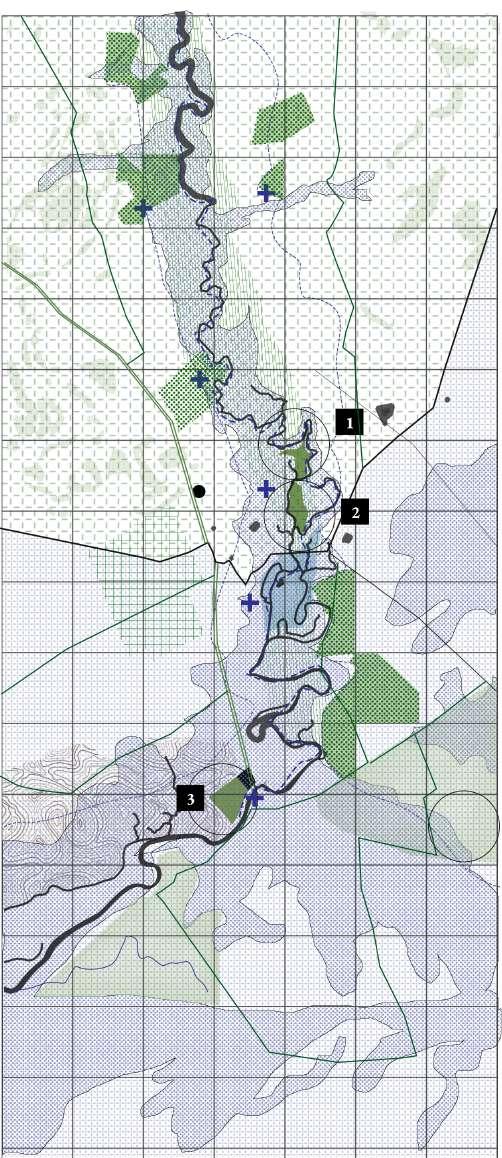
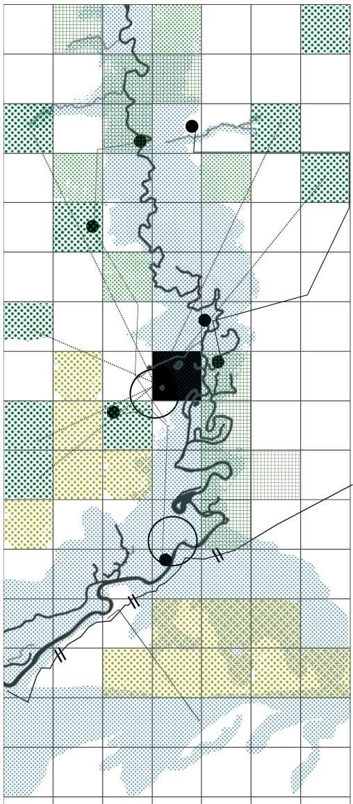
Figure 76 shows the area of Los Pajaros y sus Pueblos Libres and highlights the various pressures that the reserve faces, including those from agriculture. The map also shows the areas that have been affected by fires in the past and displays the dikes that have been constructed to manage water flows in the area. Finally, the map highlights the different routes that exist within and around the reserve, that serve as connectors but also form implications for wildlife movement and human access.
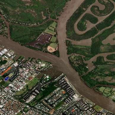
The landscape section encompassing the Zarate-Gualeguay area exhibits notable diversity, characterized by a multitude of features and land uses. The area near Zarate is characterized by urbanized zones and is a hub for the logistics and port industry, with the port of Zarate being a central player within this system. Wetlands are also prominent in the area, playing a vital role in providing essential habitats for a diverse array of plant and animal species. Agriculture, as a prominent land use, witnesses extensive large-scale farming activities throughout the region. However, the intensified farming practices give rise to a significant challenge in the form of chemical erosion. Furthermore, the extraction of water from the Parana River for irrigation purposes carries the potential to impact downstream water quality and quantity. The landscape exhibits dynamic characteristics, evident in the varying levels of water quality observed along the course of the Parana River within the region. Despite the prevailing challenges, the diverse landscapes comprising forested areas and grasslands deliver crucial ecological functions of significance.
Based on the analysis of distinct landscape units, their systemic interdependencies, and the relevant systems in place, the proposed approach entails an exploration of the diverse potentialities and practices of care within the various landscape units found in the transect. This exploration involves an examination of productive practices, augmented by the incorporation of ecotourism activities. Figure 83 depicts the levels of sensitivity within the transect, which encompasses several key zones, including the floodplain, encircled by areas of remediation, agricultural practices, riparian agriculture, and further hinterlands, fostering agricultural practice diversification. Additionally, the campo bajo region is more closely associated with the practice of regenerating natural cycles within grasslands, while also accounting for urban expansion.
In consideration of these findings, several possibilities have been identified to diversify and enhance productive and sustainable practices specific to each landscape unit, while simultaneously accounting for the required levels of sensitivity essential for their conservation. Moreover, the implementation of distinct ecotourism activities tailored to each subunit is proposed to complement these efforts.
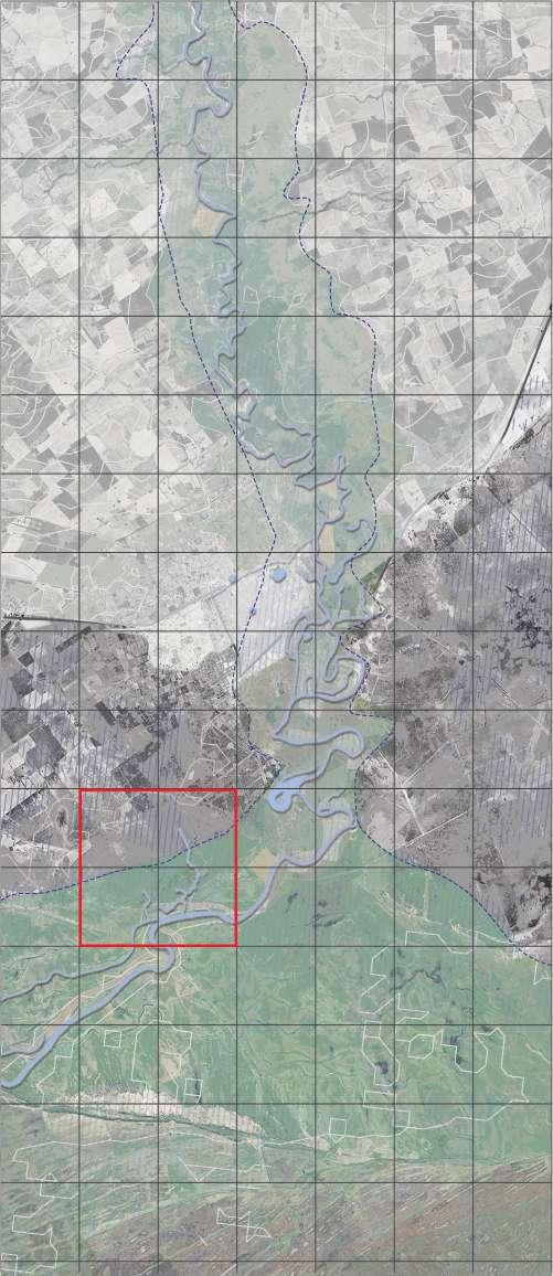
The floodplain of the Gualeguay River is an important ecological and agricultural area that supports a wide variety of plant and animal life and has an extension of around 500 km.
It exhibits a diverse combination of interconnected channels, wetlands, lagoons, and islands, which undergo perpetual modifications due to the river’s seasonal hydrological fluctuations. In the wet season, the river transcends its usual boundaries, flooding adjacent low-lying regions and engenderaing a transitory wetland ecosystem. This inundation event plays a vital role in replenishing subterranean water reservoirs while providing crucial sanctuaries for aquatic organisms, fish, avifauna, and other species habiting this environment
The dominant botanical composition within the floodplain encompasses riparian forests, comprising trees and shrubs that exhibit strong adaptability to the moist, nutrient-rich soil. These forested enclaves serve as vital habitats for avian creatures, mammals, and insects, concurrently functioning as protective buffers that safeguard riverbanks against erosive forces. Complementing these riparian woodlands, the floodplain also sustains grassland expanses and agricultural fields, which derive sustenance from river irrigation and furnish indispensable food and fiber resources to local communities.
Moreover, the Gualeguay river basin floodplain bears significant cultural and historical relevance, as evidenced by enduring human habitation stretching back millennia. The strategy embraces the Guaraní concept of ‘Ñeminity’; referring to the connection between regions and the connection between the river and people. It implies a sense of harmony and respect for the environment, and reflects the idea that all elements of nature are connected and interdependent.
Ecosystemic values
1. Provisioning services Timber; Vegetation for medicinal uses; A variety of fish species that appear in different seasons and connected with the river’s fluctuation flows; Freshwater.
2. Regulating and supporting services
Flood regulation; Water retention and purification; Recharging of the aquifers; Provision of sediments and nutrient cycling.
3. Cultural, spiritual and recreational services
Aesthetic and recreational values; The spiritual and cultural significance; Deep connection between the population and the river, creating an identitarian ownership sense and sparking genuine practices of care.
State of conservation
There is a need for more comprehensive conservation and management strategies that take into account the diverse ecosystemic values and the needs of local communities.
Overall, the state of conservation of the Gualeguay river basin floodplain is likely to vary depending on the specific location and the level of human impacts. It is important to continue monitoring the condition of this ecosystem and implementing sustainable management practices to ensure its long-term health and resilience.
Main Pressures
The floodplain faces susceptibility to environmental deterioration, specifically stemming from anthropogenic actions including deforestation, intensified agricultural practices, and urbanisation. These activities can lead to adverse consequences such as soil erosion, water contamination, and biodiversity loss. Consequently, this has effects on the ecological, economic, and cultural fabric of the floodplain. Therefore, it becomes important to adopt and enforce sustainable management strategies that protect the enduring vitality and resilience of this vital ecosystem.
The proposed approach for this area entails embracing the natural variability of river flow and establishing a harmonious relationship with it, rather than mitigating it.

Critical measures involve rehabilitating degraded and eroded areas resulting from intensive agricultural practices by implementing reforestation strategies utilizing native species. The restoration efforts aim to enhance habitat conditions for displaced species. Preserving regulatory services, including water flow regulation, flood control, and prevention of coastal erosion, is of high importance. Concurrently, it is imperative to promote ecotourism activities that foster connections between individuals and the river system, providing immersive experiences that vary in accordance with the river’s fluctuating dynamics.
During the dry season, when the floodplain emerges as the river recedes, it offers an environment useful for cultural activities, such as traditional fishing techniques, exploration of medicinal plants, and a deeper understanding of the ecosystems and their cultural significance. Guided hiking tours along the river banks afford participants a close-up encounter with diverse ecosystems, facilitating observation of the emerging flora and fauna as water levels decline. Visitors gain insights into the adaptive mechanisms of plants and animals in response to the changing conditions and recognize the vital role of this landscape unit within the broader ecological system.
In contrast, the wet season grants opportunities for canoe tours within the floodplain. This excursion permits exploration of the area while witnessing the evolving water levels. As the river overflows, an extensive network of navigable water channels arises. This season showcases distinctive flora and fauna, including an array of water birds, aquatic plants, and numerous fish species.
Campo Alto, referred to as a non-flooded region within the humid pampa, possesses a temperate and humid climate. Its soil composition, abundant in nutrients, renders it highly suitable for agricultural activities, leading to the predominant use of the land for this purpose. The natural vegetation in this area consists of edaphic species, primarily grasslands comprising a diverse assemblage of herbaceous plants varying in height. These grasslands play a pivotal role in maintaining soil structure, preventing erosion, and minimizing nutrient loss, thereby contributing significantly to regional biodiversity and soil health.
The landscape of Campo Alto is primarily characterized by extensive agricultural practices and intense economic activity focused on crop production. Soybean, wheat, maize, and sunflower are among the main crops cultivated in this region.
Ecosystemic values
1. Provisioning services
The productive capacity of this ecosystem is of paramount importance for human sustenance, as Campo Alto stands as one of Argentina’s key regions for grain and food production.
2. Regulating and supporting services
Grassland areas in Campo Alto provide valuable ecosystem services by effectively preventing soil erosion and aiding in flood regulation.
3. Cultural, spiritual and recreational services
Despite rapid changes in agricultural practices over recent decades, there remain traditional approaches to cultivation and land stewardship that reflect a rich cultural heritage and identity. Food producers are actively embracing the concept of agroecology to empower communities and promote food sovereignty.
State of conservation
Multiple factors have contributed to the transformation of Campo Alto, including changes in land use, soil degradation, and desertification resulting from excessive utilisation of pesticides and fertilizers. Furthermore, the rhythm
of agricultural practices has impeded soil recovery, leading to its exhaustion. The once extensive grassland areas have dwindled, leaving behind fragmented patches, thereby creating a highly altered environment with substantial biodiversity loss.
Agricultural expansion, intensive usage of agrochemicals, monoculture farming, and tillage practices exert significant pressure on Campo Alto, leading to ongoing soil degradation, erosion, and fertility decline. Water management practices, such as drainage and irrigation, alter hydrological cycles, impacting aquatic ecosystems and wetland habitats, ultimately affecting biodiversity and the provision of ecosystem services. Fragmentation of the landscape further impacts the situation by causing habitat loss and isolation, in effect compromising the viability of species and ecosystems. Furthermore, climate change is anticipated to exert profound effects on precipitation patterns, temperature, and extreme weather events, thereby posing additional challenges to the region.
According to the Food and Agriculture Organization of the United Nations (FAO), agroecology focuses on the meticulous design of diversified systems that strategically combine annual and perennial crops, livestock, aquatic animals, trees, soils, water, and other components within agricultural landscapes. This approach aims to optimize synergies and address the challenges posed by an evolving climate. It presents an opportunity to diversify existing agricultural practices, which currently exhibit both extensive and intensive characteristics, and transform them into nourishing and sustainable systems that promote the well-being of both humans and ecosystems.
A fundamental principle of agroecology involves reevaluating the intended beneficiaries and the methods of production, fostering a more harmonious relationship with the soil and the environment. It represents a practice rooted in care, with a comprehensive focus on collective and ecosystem health. Furthermore, it promotes reduced taxonomies and shorter supply chains, thereby fostering closer connections between producers and consumers. In Argentina, many agroecology initiatives have emerged through networks of individuals who actively share information, products, and seeds.
Beyond its ecological benefits, Agroecology holds significant potential as an economic catalyst. It is imperative to improve policies and secure funding that encourages new producers to transition towards agro-ecological production.
In areas neighboring floodplains, strategic utilization of water inflow during wet seasons allows for natural irrigation through the construction of canals, ditches, and ponds. These structures effectively retain water during rainy periods, enabling slow seepage into the soil and preventing excessive water withdrawal. Agroforestry, specifically, plays a crucial role in preserving floodplains by mitigating the impacts of flooding and erosion. The presence of trees and vegetation stabilizes soil, reduces runoff, and slows down water movement during floods, thus minimizing the risk of erosion and downstream flooding. Furthermore, the intricate root systems of trees and plants facilitate the absorption and storage of excess water in the soil, maintaining optimal moisture levels and
mitigating the severity of droughts.
For regions further away from floodplains, the implementation of crop rotation practices by farmers is key to maintaining soil health, fertility, and productivity. This approach helps prevent the accumulation of soil-borne diseases and pests while enhancing overall agricultural output. Additionally, rainfed production, which involves selectively planting crop varieties based on seasonal and cyclic patterns like ENSO (El Niño-Southern Oscillation), periodically affects this region.
Gualeguay currently offers diverse eco-tourism activities that include farm tours, culinary experiences, visits to farmers’ markets, and educational training. Expanding and promoting these activities provides opportunities to diversify extensive agriculture and raise awareness among visitors. These endeavors serve as platforms for learning about sustainable agricultural practices, local ecosystems, and the wide-ranging impacts of food production on the environment and society.
The term “Ka’aguy ndive” refers to a sustainable practice of raising domestic animals, encompassing rotational grazing, organic fertilization, and the diversification of food crops, while emphasizing respect for animal life cycles.
Campo Bajo, situated on the floodplain of the Gualeguay River, exhibits distinct vegetation adaptations to periodic flooding. During flood events, the prevailing vegetation consists of water-tolerant grassland, herbaceous species, and shrubs. In elevated areas, grasslands, quebracho trees, and carob trees dominate the landscape.
Agricultural activities in this region capitalize on the natural grasslands, which exhibit high productivity during the spring and summer seasons, providing year-round fodder for livestock.
Ecosystemic values
1. Provisioning services
The area offers valuable provisioning services such as animal feed from natural grasslands with high protein content, as well as wood, forestry products, and fresh water resources.
2. Regulating and supporting services
Campo Bajo plays a critical role in absorbing and storing significant amounts of carbon dioxide (CO2), thereby contributing to climate regulation. It also safeguards soil integrity, controls erosion, regulates the hydrological cycle, and provides vital habitats for biodiversity and wildlife.
3. Cultural, spiritual and recreational services
The region’s natural beauty and rich biodiversity make it an attractive destination for birdwatching, rural tourism, and various outdoor activities. Additionally, Campo Bajo hosts archaeological sites like Cerritos Guaranies, adding cultural significance to the area.
State of conservation
While Campo Bajo still preserves many of its existing
ecosystems, it faces considerable threats from agricultural expansion and other intensive practices.
The expansion of agriculture and livestock production poses a significant pressure, particularly due to the alteration of natural vegetation and water resources. The construction of dikes for livestock protection and urban development has disrupted natural water and sediment cycles. Extraction of natural resources, such as sand mining, excessive hunting and fishing, and high levels of chemical pollution, further compound the pressures. Additionally, river graveling for navigation purposes alters the hydrological regime of the river, leading to bank erosion and disturbances in associated wetlands and water bodies.
The proposal entails upholding the heritage of sustainable livestock practices from the Guaraní culture, advocating for meticulous care methods like livestock rotation to enable natural grass regeneration. Moreover, the introduction of Cerritos, which are soil mounds designed to retain moisture, contributes to enhanced soil fertility and productivity. Furthermore, cerritos play a significant role in sheltering and safeguarding livestock.
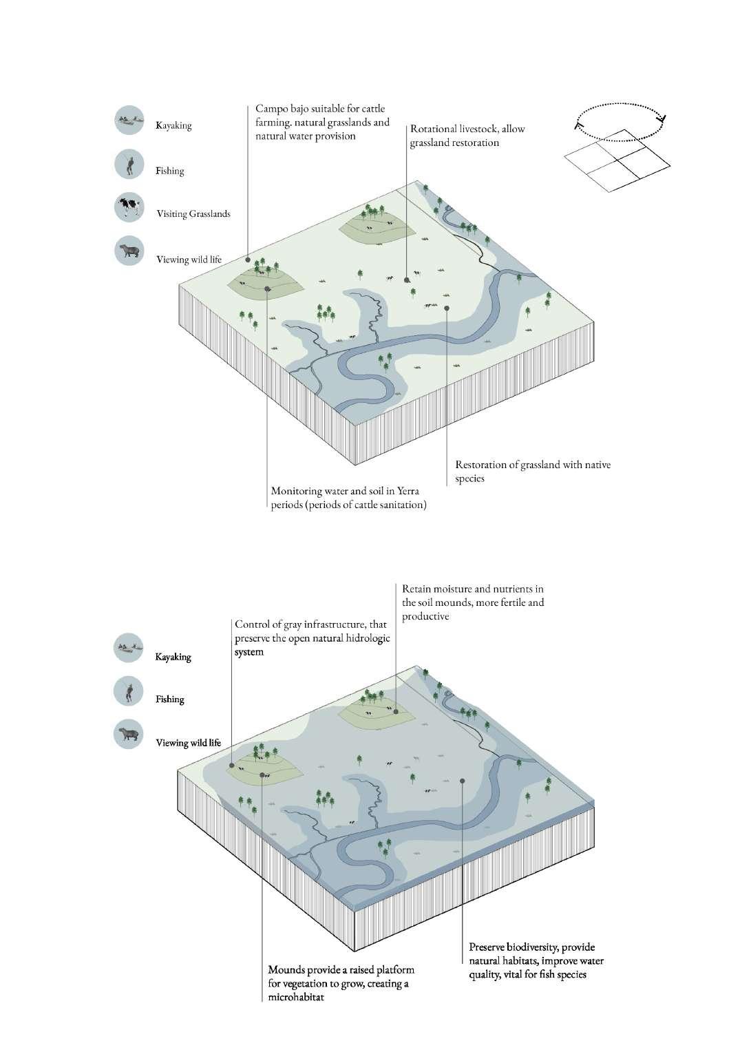
The region’s beauty, coupled with its diverse natural characteristics, serves as a compelling attraction for avian and aquatic species, rendering it a promising site for engaging in activities such as birdwatching, sport fishing, and hiking. Cultural and archaeological sites hold immense value for ecotourism, providing insights into the indigenous communities’ way of life and facilitating an understanding of water regime dynamics. Direct contact with wetlands allows for the appreciation of their aesthetic and ecological worth, shedding light on the ramifications of intensive meat production, which is identitarian to Argentina’s economic model.
Year 0: Degraded cropland is acquired
Years 1-3: Hay is fed to cattle grouped in moderate densities, compost is applied, grass is seeded
Years 3+: Animal stock densities are increased (25 to 50Mg/ha daily) and holistic planned grazing (HPG) is implemented Advanced regeneration: Represents a regenerative landscape (no seedings, added hay or compost since year 3) including rotations of diverse animal species with improved soil health and water cycling.
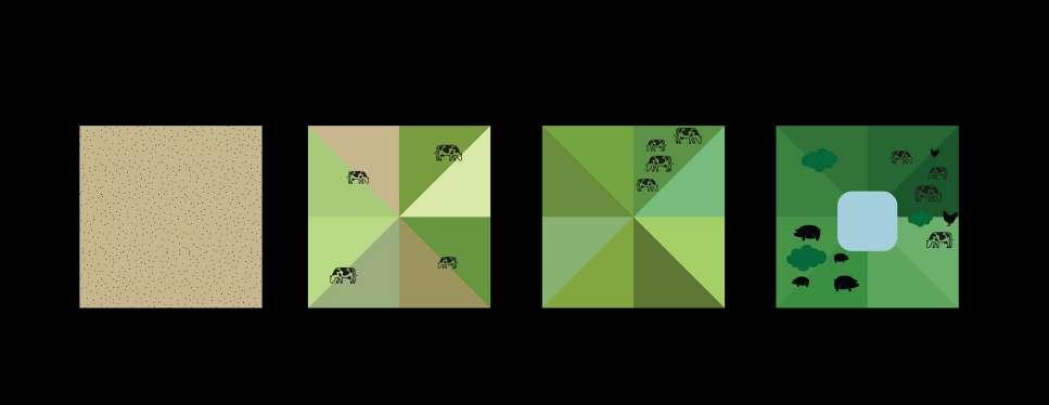
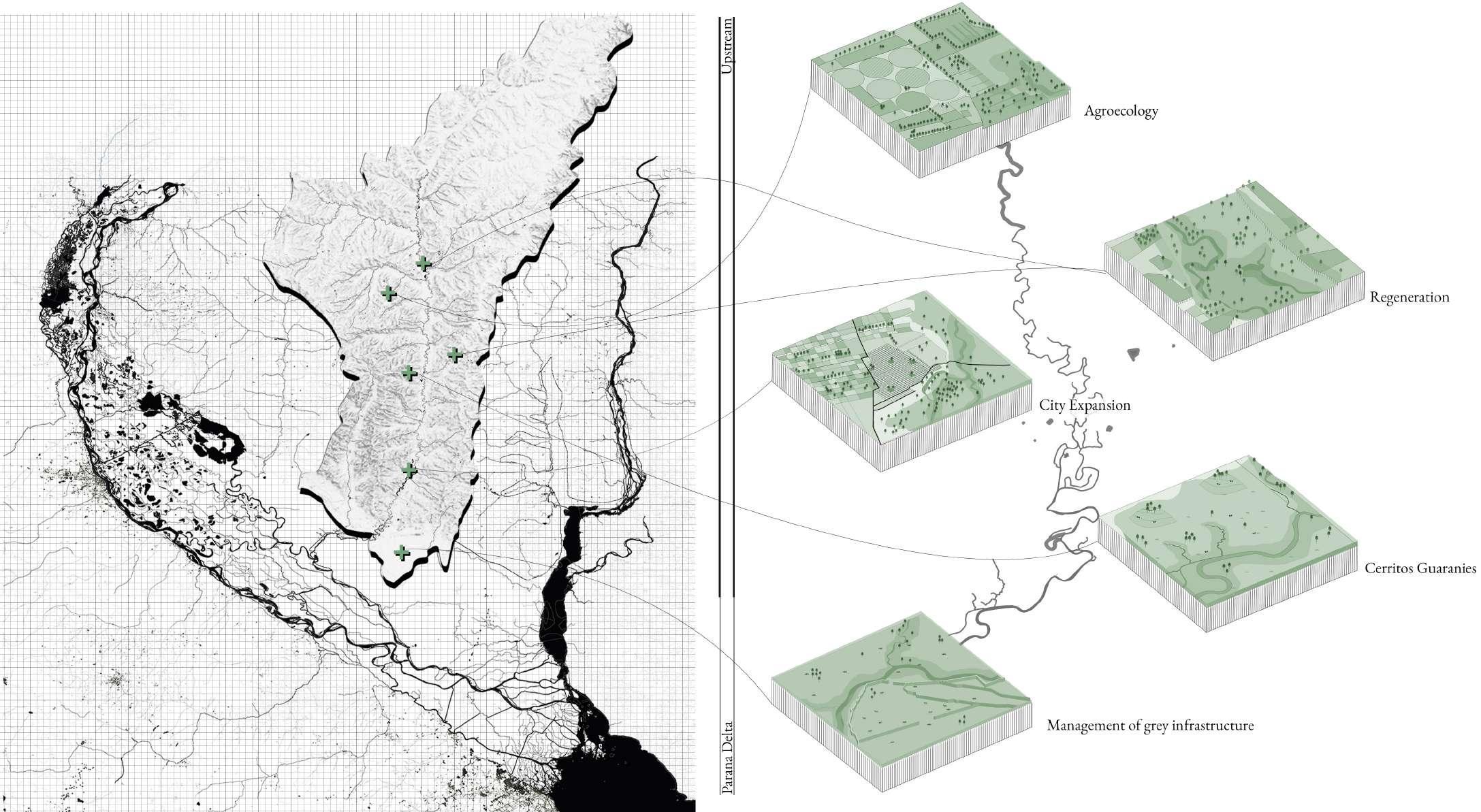
Figure 111 illustrates the vision on fostering eco-tourism in the Lower Parana Delta. Its primary objective is to promote sustainable development in the region while concurrently safeguarding its distinctive cultural and natural heritage. Eco-tourism not only yields economic benefits but also holds immense educational and awareness-raising potential. By encouraging visitors to personally experience the delta’s captivating natural allure, eco-tourism can effectively instill a sense of appreciation for the imperative of conserving the wetlands and the diverse ecosystems they nurture.
In addition to showcasing the delta’s pristine natural landscapes, the eco-tourism vision prominently highlights the region’s rich cultural heritage, encompassing archaeological sites and the enduring legacy of the Guaranies. By promoting cultural routes and facilitating activities that offer insight into the historical symbiosis between humans and the delta over the centuries, visitors can acquire a profound understanding of the region’s multifaceted tapestry.
The vision also underscores the significance of promoting sustainable food production practices within the region. Drawing inspiration from the traditional knowledge and practices of the Guaranies, eco-tourism can serve as a catalyst for promoting more harmonious and sustainable approaches to food production. By highlighting how sustainable agriculture can bolster the ecological integrity of the delta, the vision seeks to stimulate interest and awareness among individuals, elucidating the dual impacts that productive systems can exert, both positive and negative.
The fundamental objective of the eco-tourism vision is to nurture a genuine sense of value for the conservation of the delta’s innate natural and cultural heritage, guaranteeing its preservation for future generations. By actively involving visitors in immersive encounters that enable them to forge tangible connections with the region’s natural beauty and rich biodiversity, eco-tourism aims to foster a collective dedication to the principles of conservation and sustainable development. Through the implementation of initiatives that support local communities and promote responsible practices, eco-tourism becomes a pivotal catalyst for economic growth while concurrently
nurturing social and environmental sustainability within the region.
In summary, the eco-tourism vision for the Lower Parana Delta embodies a comprehensive approach to sustainable development, diligently balancing economic, social, and environmental considerations. By advocating for responsible and sustainable tourism practices, the vision aims to ensure the long-term vitality and well-being of the delta ecosystem while cultivating a profound appreciation for its unique cultural and natural heritage.
Eco-tourism for sustainable development of the Lower Parana Delta
The eco-tourism vision encompasses multiple dimensions, each focusing on distinct qualities and values associated with the area:
One aspect involves leveraging fishing, a traditional activity in the region, as an educational tool to raise awareness among tourists about sustainable resource utilization. Measures would be implemented to ensure that fishing practices are adapted to minimize ecosystem damage. Furthermore, the eco-tourism plan incorporates visits to archaeological sites to offer insights into the cultural and historical legacy of the area, particularly the heritage of the Guaranies.
Bird watching presents another avenue for exploring the exceptional natural abundance of the region. The Lower Parana Delta is home to numerous (endangered) bird species, many of which can be readily observed in different locations throughout the area. Through engaging in bird watching, visitors can have a firsthand encounter with the beauty and diverse biodiversity of the ecosystem, thereby fostering a deeper comprehension of the significance of its preservation.
The eco-tourism vision also advocates for agroecology, an agricultural approach that strives to integrate natural processes into food production methods. This practice aligns with the traditional methods employed by the Guaranies, who lived in close connection with nature and developed agricultural techniques that upheld environmental integrity. By familiarizing themselves with these techniques, tourists can witness the feasibility of sustainable food production and its positive impact on the environment.
Additionally, the eco-tourism plan encompasses the exploration of diverse natural wetland areas. Tourists can immerse themselves in unique landscapes, acquire knowledge about the area’s biodiversity, and appreciate the significance of conserving these ecosystems. Moreover, visitors can gain insights into riparian zones and their role in supporting productivity within the ecosystem.
The proposal embraces a territorial vision that acknowledges the interconnectedness and functional relationship between various cycles, including the hydrologic cycle, eco-touristic activities, and agricultural cycles. This holistic perspective recognizes the importance of understanding and respecting the natural cycles within the delta ecosystem. By acknowledging and studying these interrelationships, it seeks to develop a system of care that effectively addresses externalities and leverages the delta’s inherent potentialities.
The first phase of the strategic development plan focuses on the consolidation of the Los Pajaros y sus Pueblos Libres as a RAMSAR site, which will promote this area as an important site for ecosystem conservation. What is more, phase 1 recognises the critical zones and aims to enhance the floodplain with riparian zones, which will not only improve the ecosystem’s resilience but also provide an attractive landscape for visitors.
Furthermore, phase 1 prioritises the awareness of land productivity over time with good practices. This involves incorporating sustainable agriculture practices and promoting responsible land management to ensure the long-term health of the ecosystem. It also aims to reinstate Guaraní knowledge and practices of care, which will not only promote cultural heritage but also contribute to the sustainable management of the land.
Moreover, phase 1 aims to expand and integrate the unit into the sustainable tourism routing, thus promoting responsible tourism practices and contributing to the larger ecotourism network. By incorporating the landscape of care unit into the larger system during phase 1, a comprehensive approach will be created that addresses both ecological and social concerns. Overall, the first phase of the strategic development plan aims to establish a strong and robust foundation for sustainable development that can expand to incorporate a larger area and ultimately serve as a model for other regions.
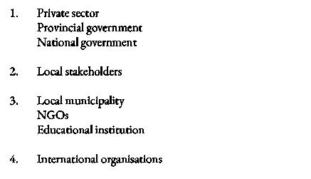
Finally, stakeholder engagement is crucial to the approach. Phase 1 aims to start creating linkages between local stakeholders, setting up the base for a system of care that can compete and ultimately integrate the powerful block mainly led by the private sector.
Agroecology
Water network

Dikes interventions
Agroecoogy farms
Floodplain
New natural Reserves
Agroecology
Reparian Agriculture
Sustainbale cattle farming
Cattle farming + cerritos
Gualeguay city
In phase 2 of the strategic development plan, the objective is to broaden the scope of the initiatives. This phase entails providing additional incentives for the areas surrounding the floodplains to become part of the sustainable development platform. By encouraging these areas to transition towards more sustainable practices, a comprehensive and holistic approach to ecosystem conservation can be ensured.
An essential element of this phase involves the restoration of critical areas along the floodplain through reforestation efforts. These efforts aim to reinforce and rejuvenate the margins, enabling the protection and regeneration of these regions. Monitoring the progress of this evolution is a crucial component of this process. It serves to contribute to biodiversity restoration, enhance the natural habitat, and bolster the overall resilience of the ecosystem. Additionally, the revival of natural grasslands impacted by fires will reinstate their vital role in soil structure and sedimentation processes.
What is more, measures are undertaken to develop immersive eco-tourism activities that align with sustainability principles within the region. Visitors are provided with the opportunity to establish a profound connection with nature, acquire comprehensive knowledge regarding the intricate dynamics of the local ecosystems, and play an active role in conservation initiatives. These immersive experiences not only provide encounters but also generate economic advantages for the local communities and establish heightened community engagement. Furthermore, the consolidation of ecotourism activities is
strategically integrated into a resilient network, ensuring long-term viability and impact.
In order to strengthen the agricultural-city link in Gualeguay, channels for the sale of locally produced goods are established. Agro-ecological production becomes integrated into the city’s food system, providing residents with access to fresh and sustainable agricultural products while supporting local farmers and promoting sustainable practices.
During this phase, the stakeholder system of care is further developed. Connections between local stakeholders are solidified, and new connections with higher levels of scale, such as municipalities and NGOs, are established. Furthermore, there is a decline in the dominance of the private sector’s power in decision-making processes.
Agroecology
Water network
Dikes interventions
Agroecoogy farms
Floodplain
New natural Reserves
Agroecology
Reparian Agriculture
Sustainbale cattle farming
Cattle farming + cerritos
Gualeguay city
Phase 3 aims at further consolidating the strategic interventions in motion. Reforestation and ecological remediation efforts are further prioritised, resulting in the successful restoration of a large number of areas. This restoration strengthens the growing biodiversity, improves soil quality, and continuously promotes sustainable agriculture.
What is more, the scope of eco-tourism activities is expanded, incorporating new private reserves into its routes. Visitors can now explore and appreciate the nature of these protected areas, including immersive bird watching experiences. These initiatives not only raise environmental awareness but further enhance the diversity of the economic model of the area for local communities.
Another crucial aspect of this phase is soil remediation. The expanding implementation of agro-ecology practices and remediation techniques, cause for the restoration of soil quality and promote sustainable agriculture. By embracing organic farming methods, crop rotation, and natural fertilisers, the soil is rejuvenated and its fertility and resilience enhanced. In this phase, remediated areas are firmly consolidated and expanded.
Stakeholder management is also further evolving during this phase. The key focus for this stage is to forge and establish the connection between private and public sector into a common system of care. Additionally, connections with international organisations and funds are established, aimed at benefiting from their expertise and financial support.
Agroecology
Water network
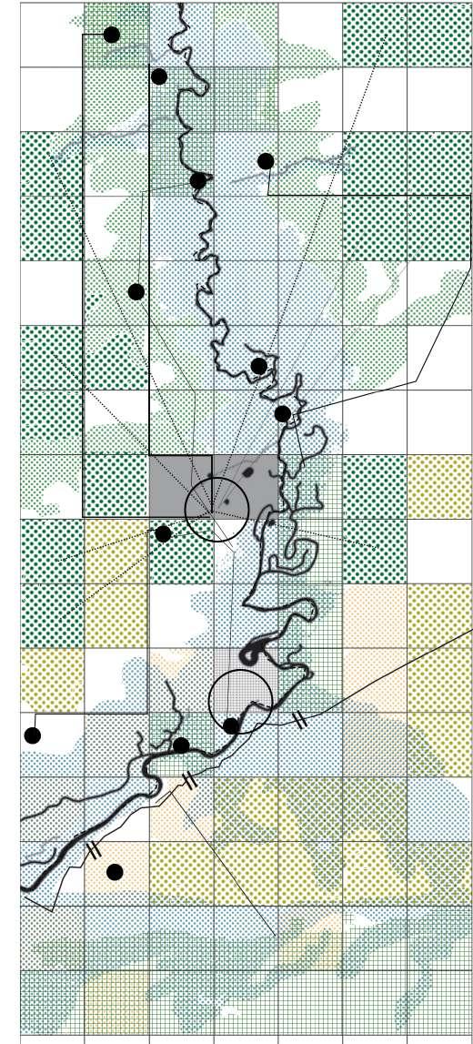
Dikes interventions

Agroecoogy farms
Floodplain
New natural Reserves
Agroecology
Reparian Agriculture
Sustainbale cattle farming
Cattle farming + cerritos
Gualeguay city

Phase 4 marks the growth phase of the evolution towards a sustainable and interconnected Parana Delta. Building upon the achievements of the previous phases, this phase focuses on the expansion of the common system of care beyond the city of Gualeguay, encompassing other areas within the delta.
Central to this phase is an adaptive replication of the successful model established in Gualeguay. By leveraging the experiences and lessons learned in Gualeguay, this phase aims to create a large-scale common system of care that encompasses the entire Parana Delta. This expansion involves the integration of other communities, landowners, and stakeholders into the framework of the common system of care, while recognizing the specific characteristics and levels of sensitivity of each tributary to the delta. To achieve this, recognizing the importance of collaborative efforts and knowledge exchange is crucial. By sharing best practices, establishing partnerships, and fostering dialogue, a network is created of stakeholders committed to the preservation and enhancement of the delta’s ecosystem services. This collective approach allows for the harnessing of the collective wisdom, resources, and experiences of diverse actors involved in the sustainable development of the region.
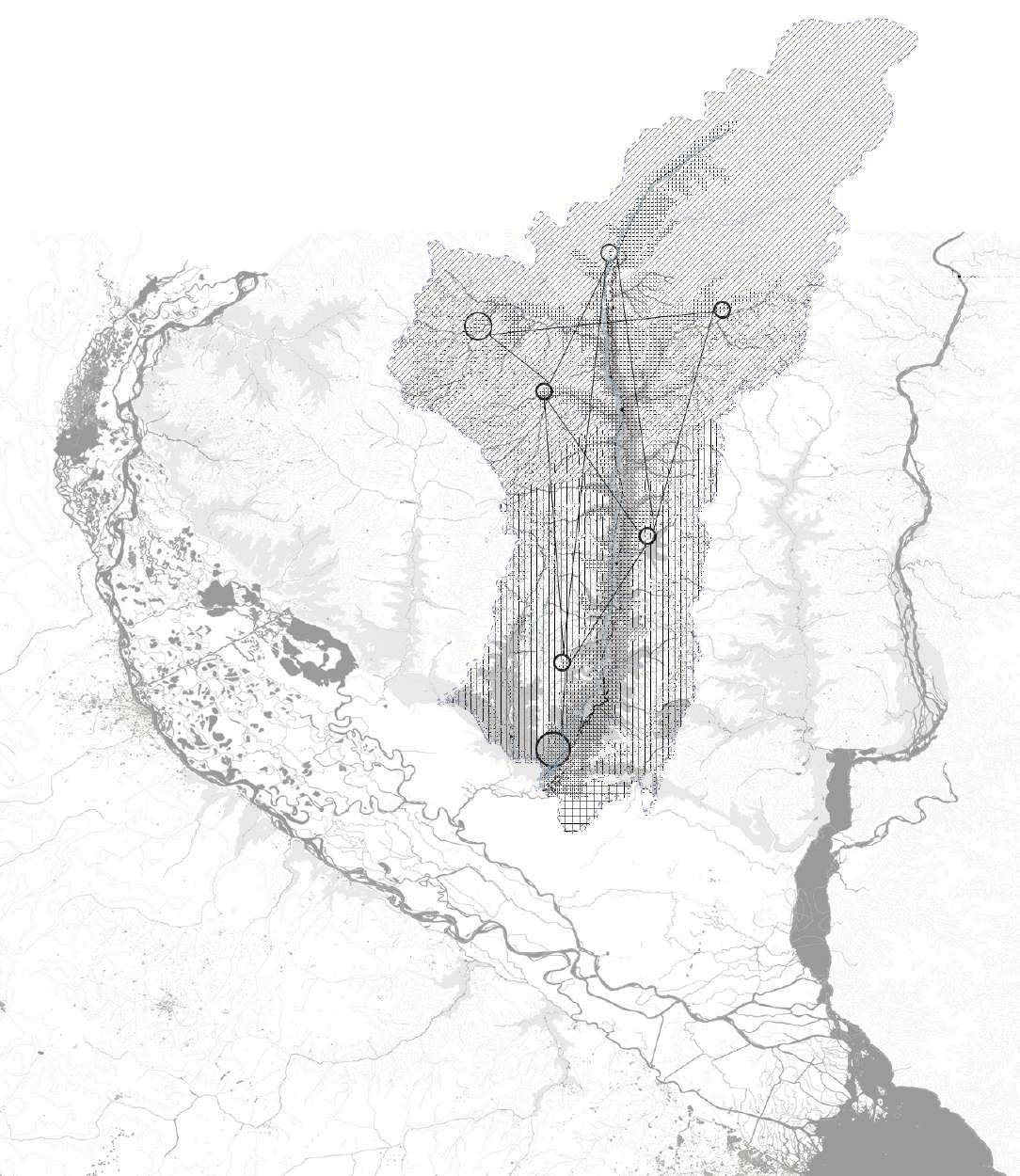
Expanding the common system of care throughout the Parana Delta promotes ecological connectivity, resilience, and long-term sustainability. By integrating various areas and communities into this framework, a unified vision and collective responsibility for the care and conservation of the delta’s natural resources is established. The expan-
sion also allows for a more comprehensive and coordinated approach to tackling common challenges and harnessing opportunities across the delta.
As the development of the area moves forward in phase 4, the strategy remains dedicated to engaging with local communities, fostering partnerships with governmental and non-governmental organisations (both public and private), and leveraging international support and funding.
Agroecology
Water network
Dikes interventions
Agroecoogy farms
Floodplain
New natural Reserves
Agroecology
Reparian Agriculture
Sustainbale cattle farming
Cattle farming + cerritos
Gualeguay city
Figure 120 illustrates the approach to enhance conservation and connectivity in the Paraná Delta, addressing several key aspects. The figure firstly highlights the creation of new access points in mature native forest areas for activities such as bird watching, recreation and education (1). Secondly, the regeneration of sand extraction areas through wetlands restoration, reforestation, agroforestry practices and the establishment of a new meeting point to facilitate knowledge sharing, alongside the implementation of seed banks to support the transition from monoculture to agroecology (2). Finally, the creation of green corridors along rural paths will connect the natural reserves within the municipality of Gualeguay (Mingueri, Boqueron, and Bolson), thereby promoting biodiversity and fostering ecological connectivity within the delta (3).
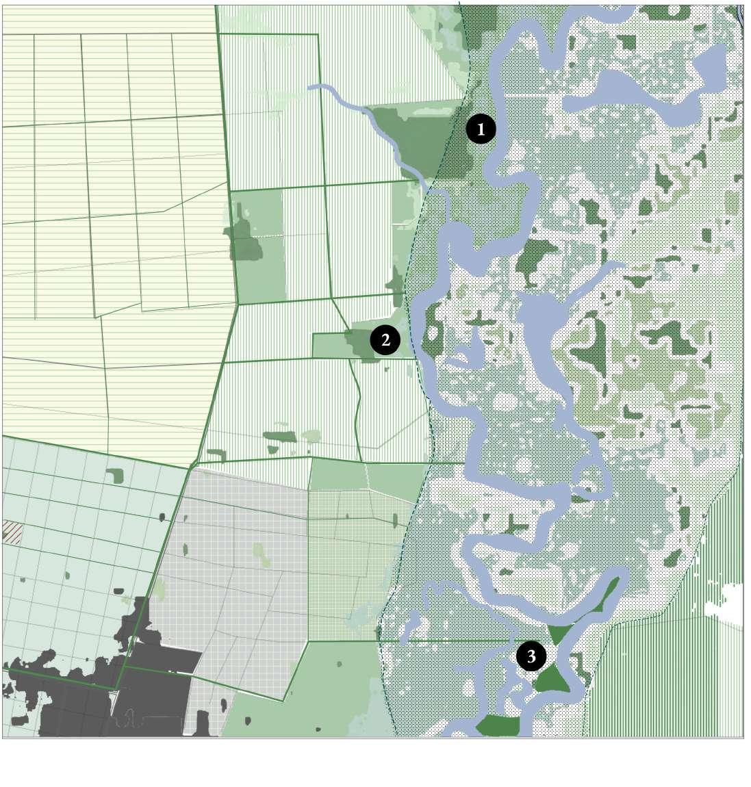
Agroecology - Rainfed and crop rotation

Riparian agriculture - agroforestry - natural irrigation
Flooding area
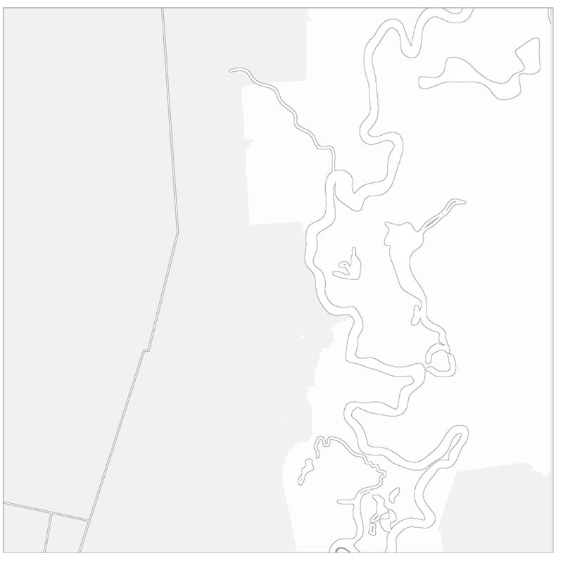
Reforestation and regeneration of native fores
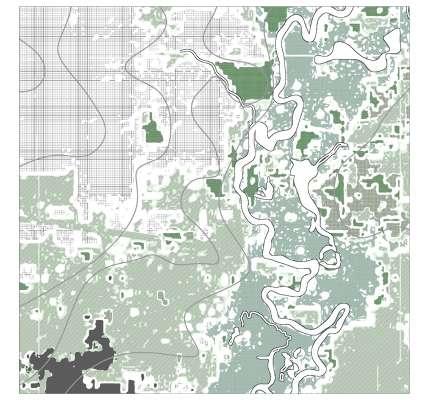
Urban area
Gualeguay River
Area of orchards
Protected mature forest
Restoration centre
Natural reserve. Mingueri, Bolson, Boqueron Green corridors along rural pathways
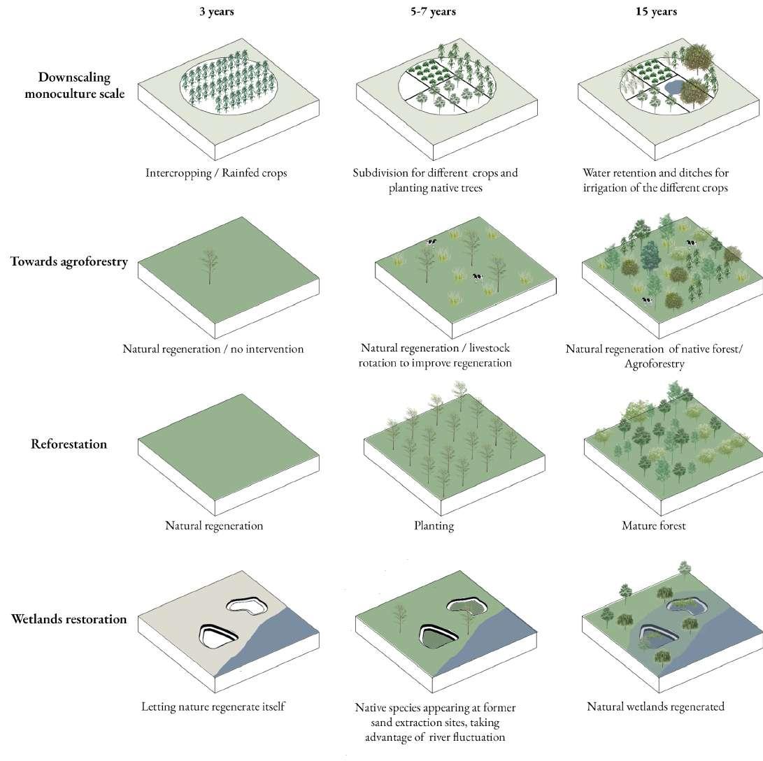
Remediation and refunctionalization of a point of sand extraction
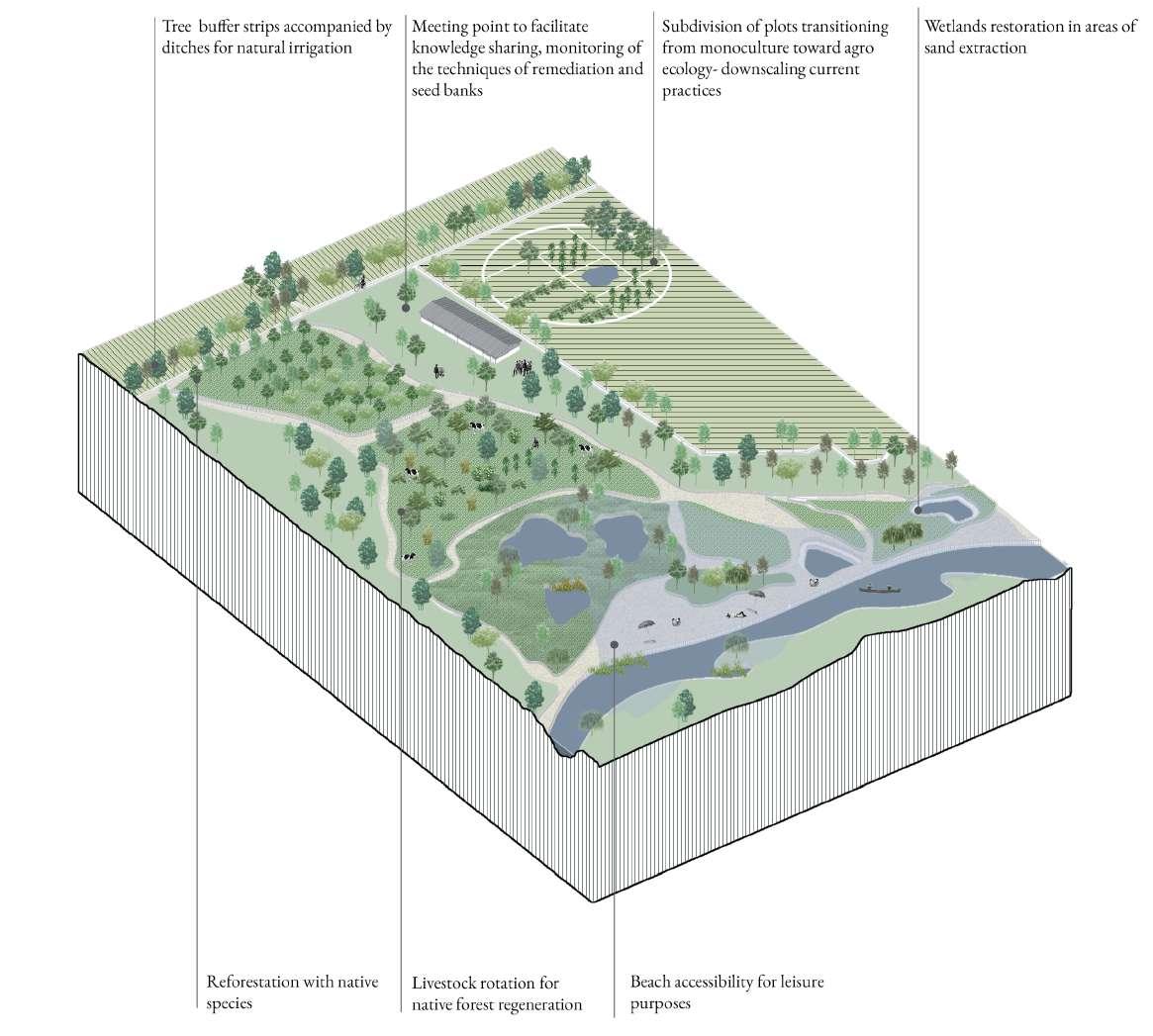

The stakeholder system operative in the Parana Delta of Argentina follows a hierarchical governance model, characterized by decision-making processes driven by power dynamics and short-term economic goals rooted in the prevailing economic system. The primary actors involved in the decision-making process are the national and provincial governments, in conjunction with the influential private sector, which holds considerable power as the predominant landowners within the region. Conversely, the municipality, despite its keen interest in promoting sustainable development within the area, lacks substantial authority.
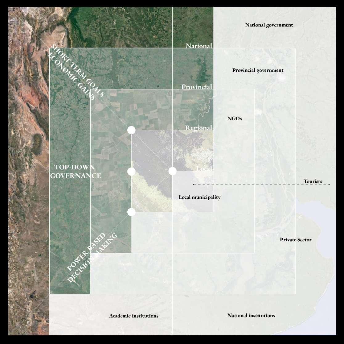
The overriding economic interests of the private sector often take precedence over the environmental and social concerns raised by other stakeholders. This narrow focus on immediate gains can result in the depletion of natural resources, carrying long-term consequences for the entire region. Additionally, the limited engagement with tourists who primarily visit Argentina for well-known attractions like Buenos Aires and Patagonia constrains the potential for sustainable tourism development in the Parana Delta.
Civil society organizations, non-governmental organizations (NGOs), and academic institutions demonstrate a resolute commitment to advancing the sustainable development of the Parana Delta. Nonetheless, their ability to wield significant influence in the decision-making process is subject to limitations. This limited engagement impedes the progress towards achieving a comprehensive and sustainable approach to regional management.
In conclusion, the present stakeholder system within the Parana Delta exhibits significant challenges that necessitate diligent attention to ensure the region’s sustainable future. A more all-encompassing and participatory methodology, engrossing the entire spectrum of stakeholders and conscientiously considering the enduring environmental and social implications, emerges as an imperative. The municipality, civil society organizations, NGOs, academic institutions, and private sector all bear indispensable roles in realizing this objective. By nurturing collaboration and cooperation among these stakeholders, a more secure and sustainable future can be effectively secured for the Parana Delta and its population.
The proposed stakeholder system embraces a bottom-up governance model, emphasizing long-term objectives centered on ecosystem-based gains and employing knowledge-driven decision-making. It allocates greater authority to local actors and emphasizes the promotion of the region’s distinctive ecosystem.
By prioritizing local participation and control in decision-making processes, this system brings about a more sustainable approach to regional management that duly considers long-term environmental and social consequences. Moreover, the prioritization of long-term goals rooted in ecosystem-based gains ensures the preservation of the Parana Delta’s natural resources for future generations.
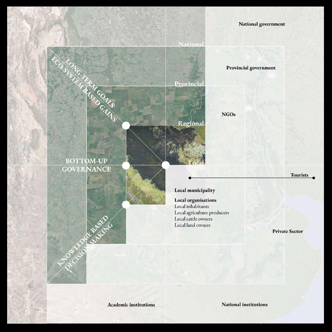
Knowledge-based decision-making entails the utilisation of scientific research and data to inform decision-making, transcending sole reliance on economic interests. Empowering local actors, including the local municipality and civil society organizations, grants them a substantive voice in the decision-making process. Furthermore, the engagement of academic institutions provides expertise and insights into the ecosystem’s requisites based on rigorous research.
Lastly, by accentuating the promotion of the region’s unique ecosystem and recognizing its significance to the locality, the development of sustainable tourism can be fostered. This, in turn, stimulates tourism growth, which can lend support to sustainable development initiatives.
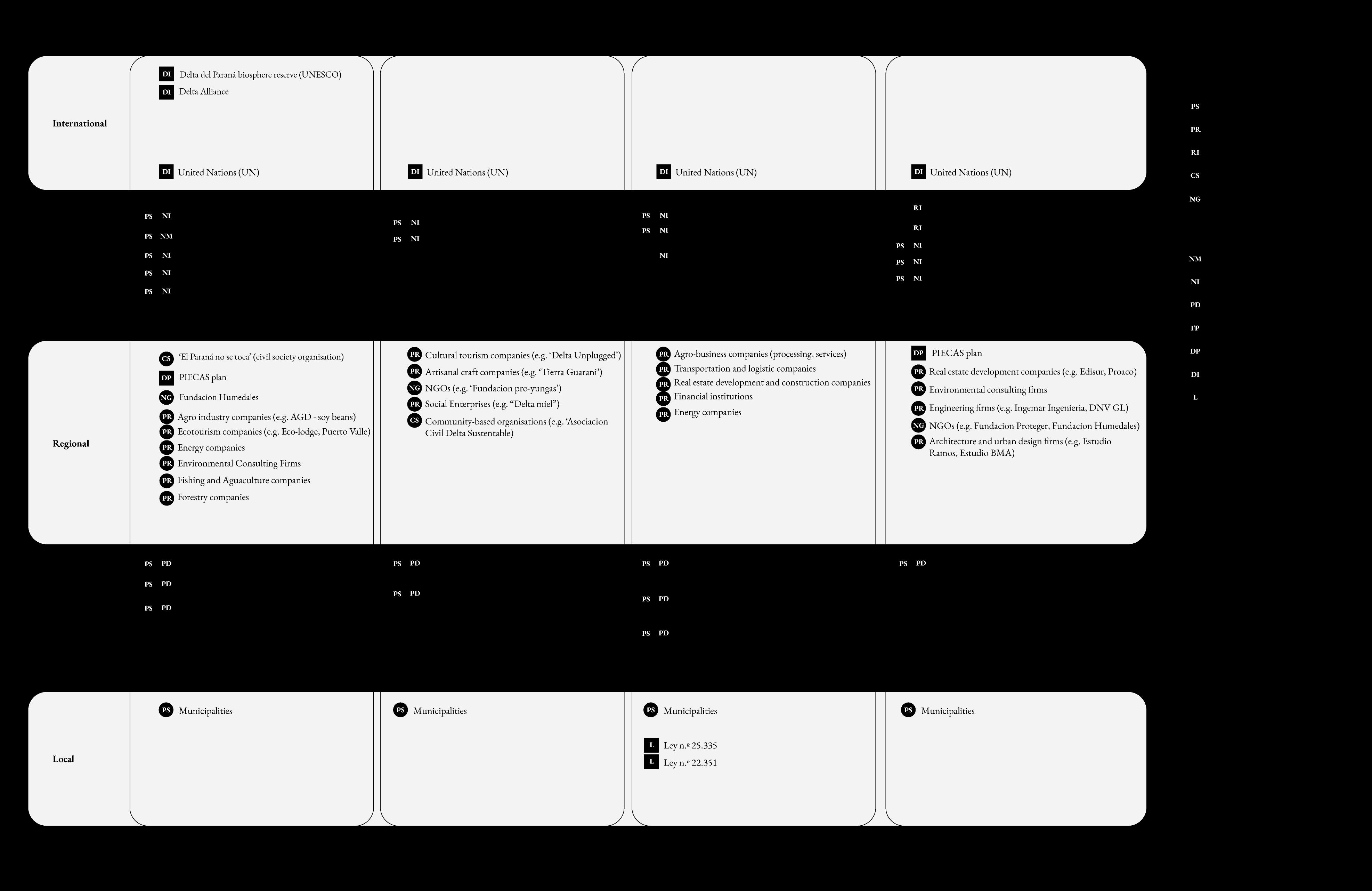
The Parana Delta in Argentina encompasses a multifaceted system wherein a diverse assemblage of stakeholders, with divergent interests and objectives, is present. While certain stakeholders demonstrate a constant commitment to advancing sustainable development, others prioritize financial gains or harbor disparate objectives that may not align harmoniously with sustainable development principles.
Within the environmental domain, stakeholders advocating for sustainable development encompass local communities, non-governmental organizations (NGOs), academic institutions, and international conservation organizations, including the United Nations (UN). Conversely, private sector stakeholders, such as landowners and business entities, may prioritize financial gains above sustainable development aspirations. Furthermore, governmental agencies tasked with economic development may prioritize short-term gains over long-term sustainability considerations.
At the socio-cultural level, local communities, indigenous groups, and cultural heritage organisations labor thoroughly to safeguard the delta’s cultural heritage and preserve its distinctive identity. Nevertheless, conflicts of interest may arise with private sector stakeholders emphasizing economic development objectives.
The economic sphere encompasses an extensive array of stakeholders, including local businesses, investors, and governmental bodies responsible for economic development. While certain stakeholders may focus on sustainable economic growth, others may prioritize immediate gains at the expense of long-term sustainability.
Lastly, at the planning level, governmental agencies vested with regional planning and land use management undertake the delicate task of reconciling environmental, socio-cultural, and economic considerations. Notwithstanding, they may encounter pressures from private sector stakeholders urging a preference for economic development over sustainability priorities.
In summary, the promotion of long-term sustainability and the advancement of the region depend upon the collaboration among stakeholders with disparate interests and objectives.
The Gualeguay region harbours a diverse deltaic ecosystem with potential to foster sustainable development and local well-being. In pursuit of these objectives, this study proposes the establishment of a Gualeguay Sustainable Development Platform (GSDP). This platform aims to convene vital stakeholders, including the Municipality of Gualeguay, private sector entities, civil society organizations, and non-governmental organizations (NGOs), to collaboratively strive towards the conservation and augmentation of ecosystem services while concurrently bolstering local well-being.
An integral feature of the GSDP resides in the composition of its governing board. The board comprises representatives from the Municipality of Gualeguay, the private sector, and civil society organizations and NGOs, thereby ensuring the representation of diverse stakeholders and the incorporation of varied sectoral requisites. Moreover, the board benefits from the guidance of research institutions, thus ensuring that policy deliberations are underpinned by the latest scientific knowledge and expertise.
The financial sustenance of the GSDP hinges upon national and international funds specifically oriented towards sustainable development. These funds serve to support a spectrum of activities, including research and monitoring endeavors, educational and awareness-raising initiatives, and the execution of sustainable development projects. Such financial backing is of strong importance in safeguarding the long-term viability of the platform and its capacity to facilitate sustainable development within the region.
The GSDP strives for two primary objectives: the promotion of local well-being and the conservation and enhancement of ecosystem services. These objectives are intrinsically intertwined and require a multidimensional approach. The GSDP can contribute to the promotion of local well-being by facilitating economic opportunities in the region, fostering social cohesion and community engagement. Simultaneously, the platform can play a pivotal
role in conserving and augmenting ecosystem services by safeguarding natural resources, enhancing biodiversity, and promoting sustainable land utilization practices.
To effectuate these objectives, the GSDP generates policy recommendations and initiatives that ascend to provincial and national levels for implementation. This approach ensures congruity between the platform’s endeavors and broader policy goals while fostering substantive impact on sustainable development within the region. By fostering collaborative partnerships with governmental agencies and other stakeholders, the GSDP endeavors to effectuate the enactment of policies and laws that champion sustainable development and guarantee the long-term well-being of the region.
Finally, the GSDP purposely looks outward and is based on the recognition of the system as a whole. While the RAMSAR mainly focuses on the conservation of the area itself and views it as an introspective system, the GSDP aims to connect to a larger system of interscalar interrelations and an expanded system of co-management.
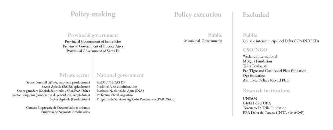
Creating a system of care requires the development of a platform of stakeholders - the Gualeguay Sustainable Development Platform - that collaborates towards a sustainable future. Setting up such a platform requires a number of subsequent steps that involve different actions related to different stakeholders.


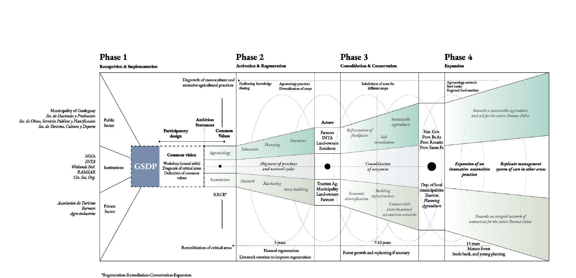

The first phase is focused on the bringing together of relevant stakeholders and guide them towards setting up a platform that defines actions and distributes responsibilities. The first step in this phase - participatory design - is to create a common vision by organising a (round table) workshop in which critical areas are diagnosed and common values are defined. The result of this step is the creation of an Ambition Statement, in which the Common Values are defined and responsibilities are distributed. Agro-ecolocy and eco-tourism are the two main backbones of change that will be further developed throughout the following phases. In phase two, actions are undertaken based on the common values set up in phase one. The actors involved in agro-ecology and eco-tourism respectively start building a common system of care. In the line of agro-ecology, education, planning and incentives, among other instruments, are utilized in order to degrow traditional agriculture practices and expand agro-ecology activities. Simultaneously, setting up a network, marketing and story-building will strengthen the role of eco-tourism. Phase three aims at the consolidation and conservation of these efforts into a robust system of care. Finally, phase four aims at replicating the management system of care in other areas by utilizing a stakeholder management based on the same values as the GSDP.