2 minute read
Monitoring heritage sites from the air
Aerial photograph from February 2020 clearly showing the main ‘desire lines’, or routes people take, when visiting Arbor Low. Hundreds of aerial images are combined to generate a 3D digital model
HELEN MALBON describes how aerial technology is shedding new light on sensitive archaeological sites
My Physical Geography PhD research at Keele University has been focused on using drones (unmanned aerial vehicles) at four earthwork heritage sites in the Peak District: Arbor Low, Gib Hill, Pilsbury Castle Hills (see Picturing the Past, p36) and Bull Ring at Dove Holes. The aim of the research was to demonstrate that aerial imagery alone can be used in low vegetation areas, such as open moorland, to document heritage landscapes and features to aid monitoring and preservation. This was done by creating photorealistic 3D models and Digital Elevation Models (DEMs). These were imported
Monitoring heritage sites from the air


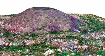
A photorealistic 3D model of Gib Hill. It has been processed using Structurefrom-Motion (SfM) which tracks features over many hundreds of aerial images and aligns them to create a 3D model. Here, soil erosion on the barrow sides is identified in the purple areas and can be measured very accurately
into a Geographic Information System (GIS) to identify and visualise areas of damage or concern, providing highly useful information for organisations such as the Peak District National Park Authority and Derbyshire County Council. The resulting images can have incredibly high resolution of around 3-4 cm – better than that which is available online as downloadable datasets. All this can be achieved by using a widely available mediumsized drone, without having to use more expensive techniques, such as LiDAR. The monitoring can be done as often as needed in order to supplement other surveys of heritage features or landscapes in order to inform their conservation. The 3D models mean that a long-lasting digital archive record of each site has also been made. An additional aim of the research was to attempt hypothetical reconstructions of the monuments, to imagine how they may have appeared when first built, using both contemporary data and archaeologists’ estimations. This part of the research is still being completed. The resulting images and 3D models – of existing features or hypothetical reconstruction – could be used in public outreach and education on various platforms, and also provide access to individuals who cannot physically visit the sites.


