Archaeology and Conservation in Derbyshire and the Peak District - Issue 22 January 2025
ACID
Inside:
Archaeology and Conservation in Derbyshire and the Peak District
Third henge site discovered
New perspectives at Peveril Community Archaeologist of the Year
Our year in numbers and pictures
ACID
Archaeology and Conservation in Derbyshire and the Peak District
Editor: Roly Smith, 33 Park Road, Bakewell, Derbyshire DE45 1AX
Tel: 01629 812034; email: roly.smith@hotmail.com
For further information (or more copies) please email Del Pickup at: del.pickup@peakdistrict.gov.uk
Designed by: Sheryl Todd, Moose Design sherylt38@yahoo.co.uk
The Committee wishes to thank our sponsors, the Peak District National Park Authority, Derbyshire Archaeological Society, ON Bookshop,
Foreword:
An exciting year ahead!
It is a great pleasure to invite you to explore this year’s ACID magazine as it was uncertain whether we would be able to publish a hard-copy magazine due to changes in our funding.
Continued support from Peak District National Park Authority, along with generous donations from Derbyshire Archaeological Society, ON Bookshop, and the Hunter Archaeological Society, and a public crowdfunding appeal meant we were able to commission and print the magazine. Thank you to everyone who has contributed.
Industrial archaeology features strongly in this year’s edition, reflecting the importance of this more recent period in the area’s heritage. Coal and copper mining, railway heritage and brickmaking are examined. The significance of historic buildings is explored through ‘A Day in the Life of an historic buildings consultant’ and the work of the Derbyshire Historic Buildings Trust, while reports on Haddon Hall’s Bell Turret and a former pub at Wensley give detailed information on aspects of buildings archaeology.
2
16 ‘Bricking it’ in Matlock Martyn Thomas uncovers a long-forgotten brickworks in Matlock
The use of technology in archaeological investigations at Peveril Castle, Cromford Bridge chapel, Morley Park ironworks and Tissington silo is highlighted, combining on-the-ground surveying with new technologies that enable new perspectives to be gained.
Several articles report on activities run for and by children and young people, such as Derbyshire Scouts Archaeology, Peak District Young Archaeologists’ Club and University of Nottingham’s Digital Transformations Hub. These initiatives provide fantastic opportunities to develop future archaeologists, both professional and hobbyists, and enable cross-generational skills and knowledge exchange.
There is much more to enjoy in this edition of ACID and much to look forward to in Derbyshire and Peak District archaeology in 2025, such as new displays at Derby Museum and Art Gallery and a new website for Hunter Archaeological Society. It will be an exciting year!
Martha Jasko-Lawrence Chair of the Derbyshire Archaeological Advisory Committee
4 Third henge monument discovered Tim Cockrell reports on the exciting discovery of a previously unrecorded henge monument near Sheldon
6 A new perspective on Peveril Castle Colin Merrony explains how surveys have cast a new light on the layout of Peveril Castle
8 Belper’s mystery railway A long-forgotten railway is revealed by Trevor Griffin
9 When Long Eaton was a railway hub
Ian Mitchell describes the installation of new history panels at Long Eaton station
10 Historic mining between Chesterfield and Creswell
John Barnatt describes his five-year survey of former coal mines in NE Derbyshire
12 A Day in the Life of... an historic buildings consultant
Matt Hurford describes a typical day in his life to editor Roly Smith
14 Keeping time at Haddon Hall
Stephen Coates relates the timeless story of the clocks in the Bell Turret at Haddon Hall
15 Papering over the cracks at Wensley Renovations at a former Wensley pub have revealed a glimpse of yesterday’s news, as Richard Pougher reports
18 ‘A living museum of industrial heritage’ Ashley Franklin describes the story behind a new book on the Derwent Valley Mills WHS
20 Find of the Year: Possible harness link to Sutton Hoo Derbyshire’s Finds Liaison Officer Meghan King describes the fragment of a possible Saxon horse harness mount found in Elvaston
21 Derbyshire Scouts are prepared for anything!
Derbyshire Scouts Archaeology goes from strength to strength, as Morgause Lomas reports
22 Historic copper mine no longer at risk Fiona Stubbs describes the conservation of Ecton Mine balance cone – one of the country’s most important historic mining sites
23 Family archaeology event at Castleton
The Peak District National Park’s contribution to last year’s national Festival of Archaeology was a family event at Castleton, as Alison Riley reports
24 News from round the county National Park archaeologist wins national award and a warm ‘thank you’ to Ros
25 From paved path to pollen in a peat bog Catherine Parker Heath with an update on the work of the cultural heritage volunteers
26 From Medieval mouthwashes to Mesolithic fishing Peak District Young Archaeologists’ Club has had another busy year, as Martha Jasko-Lawrence reports
27 Shedding a laser light on landmarks Rosemary Annable of the Derbyshire Archaeological Society reports on its use of geospatial surveys on Derbyshire’s most famous landmarks
28 Saving Derbyshire’s heritage Allan Morrison of the Derbyshire Historic Buildings Trust describes the Trust’s latest project
29 New archaeology display at Derby Museums
30 The Hunter goes digital Anna Bloxham of the Hunter Archaeological Society, explains how it is digitalising its journal
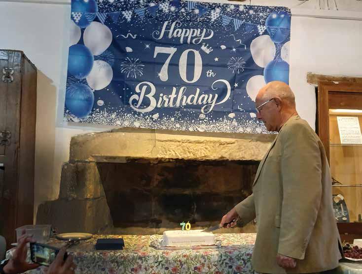
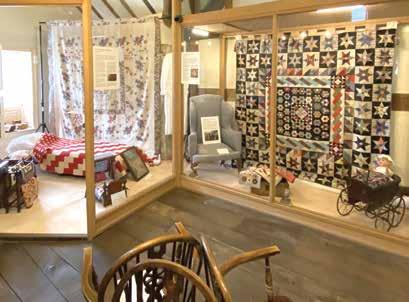
31 Double celebration for Bakewell museum Bakewell’s Museum Manager Mark Copley looks forward to an exciting year in 2025
32 Bookshelf
Editor Roly Smith reviews the latest archaeological books on the county
34 Our year in numbers Planning and heritage statistics for the past year
35 Our year in pictures
A pictorial selection of some of the things we’ve been up to
36 Picturing the Past The face of the ‘Repton Warrior’ 10 12 18 6 30 26
Foreword Martha Jasko-Lawrence, chair of the Derbyshire Archaeological Advisory Committee
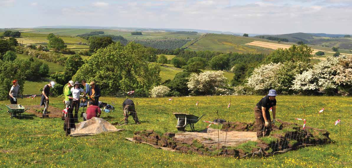
Third henge monument discovered
COCKRELL, Research Associate at the University of Sheffield’s Department of Archaeology, reports on the exciting discovery of a previously unrecorded henge monument near Sheldon
Derbyshire is famous for its impressive henge monuments at Arbor Low and the similar Bull Ring at Dove Holes. Until recently these were thought to be the sole representatives of this class of prehistoric monuments in the county.
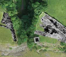
However in 2022, Mick Parker, then a mature student studying history at the University of Derby, detected a circular, ditched and banked enclosure visible in LiDAR imagery at Sheldon near Bakewell that looked very similar to henge monuments, for which no archaeological record appeared to exist.
The site was disturbed by lead mining works on its west side and the east side was ploughed out, apart from the slight trace of a circular embankment. Mick reported his discovery to the Peak District National Park’s heritage conservation team who not only confirmed the lack of an existing record, but also thought it worthy of further investigation.
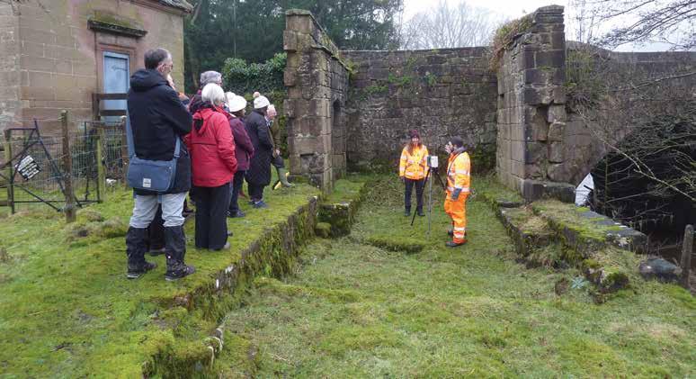
The heritage team contacted Colin Merrony at the University of Sheffield’s Department of Archaeology with a view to using remote sensing techniques. More detailed images obtained might confirm or deny the essential morphology of the feature and add detail, such as the location of an entrance, and the continuation of the ditch on the east side. The exercise would also provide experience for students in need of small projects to meet the requirements of their undergraduate learning.
Over the winter of 2022-23, drone surveys for photographs to be used in structure from motion 3D modelling of the site, geophysical surveys utilising resistivity and magnetometry, as well as ground generating radar, were undertaken.
Surveying the west side of the enclosure
The work produced more detailed models of the locale than that available from LiDAR data, improving understanding of the morphology of the enclosure, its relationship to later disturbance in the form of lead mining works and the local topography. The results from geophysical surveys confirmed the presence of a ditch-like feature on the west side of the monument, but on the east side were inconclusive.
However, ground penetrating radar on the east side of the monument confirmed the presence not only of an internal ditch and external bank, but a probable entrance. Consequently, trial excavations were proposed to obtain more detailed information to characterise its use and date.
In the summer of 2023, trench one investigated the entrance, as well as part of the area enclosed by the bank and ditch to seek evidence for internal features. Trench two investigated the bank and ditch on the west side. The physical character of the enclosure was confirmed, with a rubble bank enclosing a rock cut ditch with a flat bottom.
No pottery was recovered, but a small assemblage of flintwork was found, some of which probably relates to the Late Neolithic or Early Bronze Age. A larger assemblage of
Ground penetrating radar on the east side of the monument confirmed the presence not only of an an internal ditch and external bank, but a probable entrance
chert artefacts was found, mainly in the ditch terminal in trench one. Some of this material relates to the Mesolithic, indicating a use of the locale long predating the enclosure itself. Much more was of indeterminate date, utilising poor quality chert and chert-like material almost certainly on an opportunistic basis.
No material culture that might suggest a date later than
the Late Neolithic or Early Bronze Age was recovered. No archaeological features, and very little material, was recovered from the internal area.
Small amounts of animal material were recovered from basal deposits of the ditch in both trenches, from which radiocarbon dates are hoped to be obtained.
The results offered no evidence to support an interpretation of the enclosure other than that of a ceremonial enclosure of the Late Neolithic. Further work planned is designed to investigate in more detail possible activities within the enclosure, and to seek a possible second entrance, but there can be little doubt that the enclosure at Sheldon is indeed a third henge monument for the region.
TIM
Opening trench 2 on the west side of the enclosure (above)
Excavating the ditch terminal in trench 1 (left)
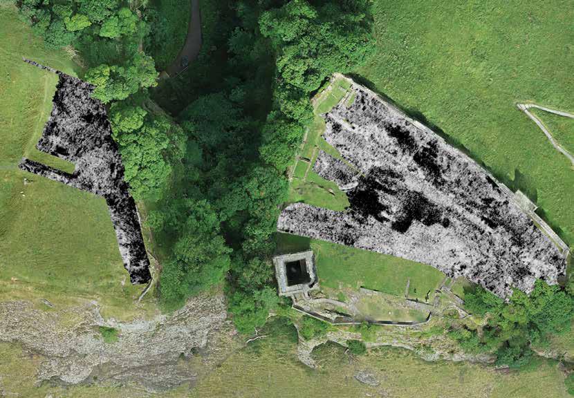
New perspective on Peveril Castle
COLIN MERRONY of Sheffield University explains how surveys have cast a new light on the layout of Peveril Castle
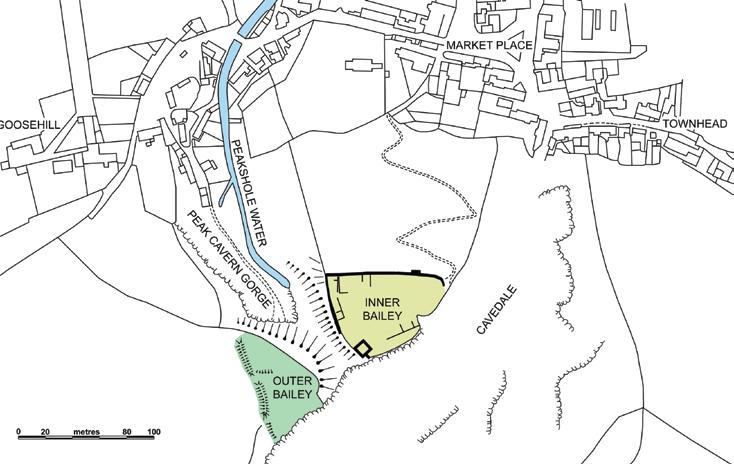
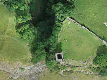
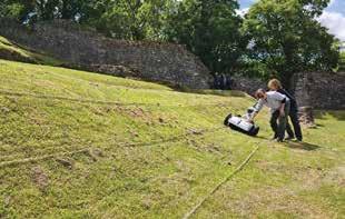
Peveril Castle is a well-known Derbyshire medieval landmark, dominating Castleton and visited by more than 30,000 people every year. While the English Heritage property includes the main inner bailey area and offers wonderful views of the head of the Hope Valley, much less visited and outside the EH property is an outer bailey, which lies on the other side of the gorge above Peak Cavern. Reconstructions of the castle at its height always show the outer bailey containing buildings such as stables and barns. In the summer of 2022, as part of Clara Thomas’s MA fieldwork, archaeologists from the University of Sheffield undertook a drone survey of Peveril Castle and its setting. At the same time, they also completed a Ground Penetrating Radar (GPR) survey within parts of both the inner and outer baileys.
The drone survey enabled the production a detailed three-dimensional digital model of the castle and some of the surrounding landscape. This was achieved using a method called Structure from Motion, where more than 600 overlapping vertical photographs were taken by the drone flying a systematic pattern over Peveril Castle. The software then stiches them together to form a single high-resolution
vertical image called an orthophoto, and then creates a digital 3D model of the area.
The GPR survey was completed over most of the area, despite the steep slopes which cover much of the ground within the inner and outer baileys. However, some parts, particularly of the outer bailey, were so steep that it proved impossible to conduct the survey.
The GPR showed the location of buildings within the
inner bailey as expected but provided no indication of buildings in the outer bailey. It was quickly realised by the team that the outer bailey was not only sloping very steeply over almost all its area, but the upper part was also higher than the inner bailey. In fact, the top of the outer bailey area is roughly level with the upper part of the keep.
The results of the geophysical survey and the clearer understanding of the topography of the site dispels any idea that this would have been a service area for the castle with buildings such as stables, barns, workshops, or accommodation. There is no evidence of terracing or building foundations which could have allowed the area to be suitable for these uses. Instead, the outer bailey was enclosed as a necessary security measure. While the outer bailey will have provided an additional entrance into the castle from the top of the ridge which runs to the south-west from the castle, this cannot have been an area that was included within the castle to provide space for stables and other buildings.
This was an area however, which needed to be secured so that the keep and inner bailey were not vulnerable to an attack from this higher ground. The result is the large, still visible, earthwork which marks the line of the enclosing rampart, which ensured that anyone outside the castle was kept to lower ground.
Hopefully, future reconstructions of the castle will show the outer bailey in a more realistic form. In the meantime, the outer bailey is well worth a visit and is only a short distance up the slope from the footpath that runs from Goosehill in Castleton to Speedwell Cavern.
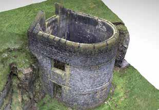
Vertical orthophoto view of Peveril Castle created from overlapping individual detailed photographs taken by a drone
Example of the results of the GPR survey overlain on the orthophoto of Peveril Castle
GPR survey underway in the inner bailey with Dr Guglielmo Strappazon and Dr Nina Maaranen working to keep the GPR unit moving in a straight line despite the steep slope
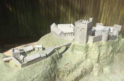
Reconstruction in the English Heritage visitor centre (above) of how Peveril Castle may have looked, indicating clearly that the outer bailey (on the left) is supposed to be flat and lower than the inner bailey.
Plan of Peveril Castle, showing the inner and outer baileys
looking west with hawthorn hedge following the edge of the curve
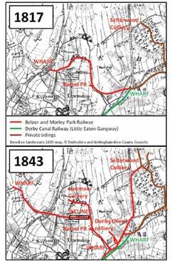
Belper’s mystery railway
TREVOR GRFFIN and JANE ROGERS report on the discovery of an early railway line at Little Eaton
Aplanning application to build homes and factories between Denby and the A38 has brought an important early railway back into focus.
John Farey recorded the construction of the Belper and Morley Park Railway (B&MPR) in his survey published in 1817.
Benjamin Outram extended the Derby Canal as a railway from Little Eaton Basin to Smithy Houses in 1795. It was worked by “gangs” of wagons pulled by horses.
OS maps from 1817 and 1843 show the line and its extensions
Peter Stevenson finally revealed in 1973 that what had been thought of as branches of the Derby Canal Railway were originally part of the B&MPR.
Belper had been bypassed by the Cromford Canal and it was difficult to get the coal needed to heat the new homes and mills.
In 1801 William Strutt commissioned plans for a railway to link Belper to the Cromford Canal. He abandoned this scheme in 1804, probably because William Drury Lowe had commissioned surveys to link his private colliery railways in the Denby area to a coal wharf near Belper marketplace.
This line was built, as Farey observed, from Smithy Houses to a coal wharf at Openwoodgate, beside an old road that linked the two.
Extension into Belper proved difficult because landowner permission was needed, it was not an authorised railway. Horses had to drag loaded
coal wagons up a steep hill to Openwoodgate. By 1830 the railway had been almost completely rerouted and upgraded. One feature was an incline to avoid this by hauling wagons using the winding engine at Hilltop Colliery.
The Belper extension finally opened in 1842. It ran beside Kilburn Road to a coal wharf located where Pottery School now stands. The extension was only in use for a few years because the North Midland Railway now served the town.
The Midland Railway plans for the Little Eaton to Ripley branch line of 1847 show that the B&MPR by now had a coal wharf with extensive sidings serving Denby and also had a junction to the Derby Canal line.
Bits of the Railway survived as sidings to the canal railway and a short section remained in use until 1908.
It is still possible to walk either along or close alongside 80% percent of the 4km route using public rights of way. Most of the old alignment beside Kilburn Road in Belper remains visible and elsewhere one can walk along embankments and see distinctive stone arch culverts across streams.
A few stone sleeper blocks survive in modern walls. In 2019 members of the Derbyshire Archaeological Society examined part of the 1842 extension. The compacted formation was found but no traces of trackwork or ballast.
Two sleeper blocks found nearby were examined, these show the extension may have been laid with the blocks placed diagonally rather than the earlier technique of arranging them in parallel.
The outstanding feature is the lower half of the Hilltop incline, where stone sleepers can be seen from time to time under a layer of mud. Measurements taken here confirm that the track gauge was the standard Outram one of 4’2” (1.27m) between the backs of the upright rail flanges. The spacing also confirms that plate rails 3 foot (914mm) long were used. In 2024 an attempt was made to schedule the incline as an Ancient Monument. Historic England refused the application, the criteria are now very strict, but recognised it as being of local importance.
Awareness of this elusive old railway as both an important local heritage and leisure asset has increased thanks to the threat to its most significant remaining feature.
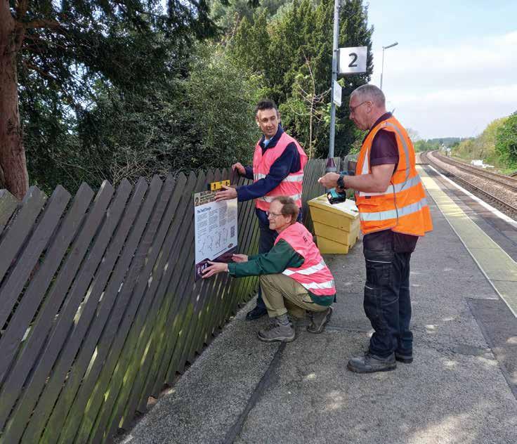
When Long Eaton was a railway hub
IAN MITCHELL, chair of the Derbyshire Archaeological Society’s Industrial Archaeology Section, describes the installation of new history panels at Long Eaton station
The Community Rail Movement brings together train operating companies, local authorities and volunteers to improve local railway stations and promote their use.
Much of the effort of the so-called ‘station adopters’ goes into keeping the stations tidy and attractive, looking after garden areas and floral planters on the platforms. But some adopters are expanding their role to research and interpret the history of their station and its locality.
One of the first examples of this in Derbyshire is at Long Eaton, where history panels have been installed on the platforms and in the station car park. Two of the panels – the Trent Triangle and ‘Long Eaton’s Four Stations – describe the evolution of the triangular railway junction where the lines from Derby, Nottingham and Leicester meet at Long Eaton, and how this resulted in four stations bearing the town’s name at various times.
Another panel describes the stone-arched Tamworth Road Bridge that carries the railway over the main road by the station and explains why it has been susceptible to flooding ever since its original construction in 1838. The final panel describes how tarpaulins were made to cover open railway wagons at the Midland Railway Sheet Stores, located where the railway line crosses the Erewash Canal. The history panels draw on articles I have previously published in the Derbyshire Archaeological Journal and Derbyshire Miscellany and bring these stories to a wider audience.
Complementing the station history panels is a six-mile walk exploring the history of the railways and canals around the Trent Triangle’.
A QR code on one of the panels links to detailed route instructions and historical information on the Derwent Valley Line Community Rail Partnership website. You can also use this link to view copies of the history panels when away from the station.
The incline to Hill Top farm
Alastair Morley (Derbyshire County Council), Ian Mitchell (Station Adopter) and Kevin Knight (East Midlands Railway) installing the panel on Platform 2 at Long Eaton station
The QR Code for the walk and historical information
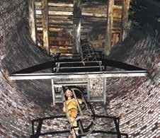
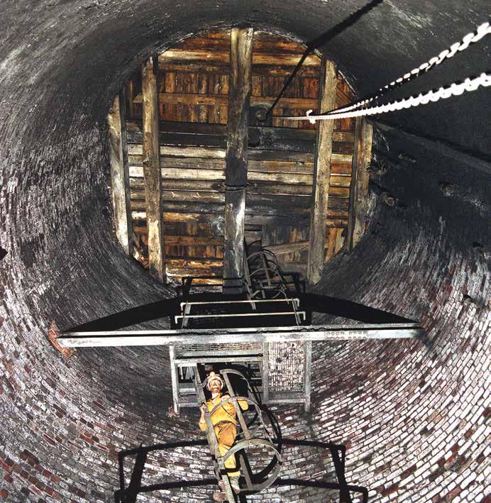
An access route in a shaft at Bolsover Colliery, photographed in 1993; its top at surface is now sealed with concrete Picture: the late Paul Deakin
Historic mining between Chesterfield and Creswell
JOHN BARNATT took advantage of the Covid lockdown to conduct a major, five-year survey of coal mines in NE Derbyshire
Following my interest in historic mines, during the first Covid lockdown, I started exploring on foot around where I had lived since 2018. I guessed there may have once been 50 coal and ironstone mines within five miles of my house at Mastin Moor – but it turned out I was way out in my estimate.
At a time of climate change, increasing non-dependence on fossil fuels and with coal mining confined to history three decades since the last local National Coal Board mines closed, it seemed an appropriate moment to start to reassess the local history of this industry and how it developed through time.
The wounds inflicted on local communities by the Miners’ Strike in the 1980s are deep, but for many now not as raw. What was its impact on the landscape and how much of the surface remains of the collieries and their waste heaps has been remediated? What old industrial buildings and other archaeological vestiges could be saved for future generations?
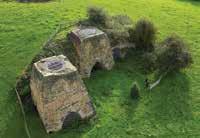
The extent of coal removal at Norbriggs Colliery near Staveley derived for surviving mine plans. This mine was created by the Chesterfield Canal Company in the late 1770s, founded to invigorate local mining. One of the shafts lay in the next field to John’s home, but was not identified during searches made before purchase
Renishaw Park East Colliery, as mapped by the Ordnance Survey in 1875, coloured to show: engine and boiler houses (red), screens (yellow), workshops (blue), cottages (purple), coke ovens (green) and water storage (pale blue).
These will remind people of the positive impacts of the Industrial Revolution, but also the negative impacts on the environment and the long-term folly of the dangerous path trodden over the last 250 years.
The study has broken new ground by looking at part of a major coalfield by seeing what could be learned from an in-depth study, rather than relying on our current broadbrush understandings. It was undertaken in a 170sq km area that extends from the River Rother by Chesterfield in the west to Creswell, 17km to the east. Its northern edge is the old Derbyshire/Yorkshire boundary and thus took in Mosborough, while 14km to the south it included Bolsover and Sutton Scarsdale.
Initially historic maps and websites were searched online. Later, when Covid was not so prevalent, long visits were made to the Record Office at Matlock and Sheffield Archives, while others viewed mine plans held in Coal Authority archives. Extensive fieldwork included searching areas where Google Earth imagery and Lidar mapping by the Environment Agency suggested mine earthworks remained.
Five years on, 337 definite collieries and ironstone mines of 18th to 20th century date have been identified. There was also earlier mining, the earliest documented being in 1366, where the parish, but not specific locations, are known.
Mining in the local area changed radically in scale and methods of working from the 18th to the late-20th
century. Early mining often comprised multiple shallow shafts accrued over time as coal seams were followed. Deeper mining using steam pumping engines started in the 1750s-60s.
The creation of the Chesterfield Canal in the 1770s led to coke-fuelled ironworks being set up at Staveley and Renishaw. These became major consumers of raw materials with their mines working on more of an industrial scale. With the coming of local railways in 1840, collieries started to be built that we would recognise from old photographs, with their deep shafts, headframes for cages, engine houses, coal processing screens, extensive railway sidings and miners’ housing.
By the end of the 20th century when the local mining industry had effectively collapsed, north-eastern Derbyshire was not so much part of “England’s green and pleasant land” as a ravaged landscape with demolished collieries and abandoned ironworks and chemical plants. Beyond large areas of 19th and 20th century housing, agricultural land had often lost its archaeological features where extensive parts of the ground had been opencast for coal.
While much has been destroyed, three nationally important mine-related sites have been made Scheduled Monuments. There are also a further 33 regionally important sites currently offered no legal protection. Given their relative rarity, we need to care more for them if we want to leave reminders of the mining industry for future generations.
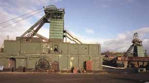
The headstock of Bolsover Colliery in 1993 shortly before demolition Picture: the late Paul Deakin
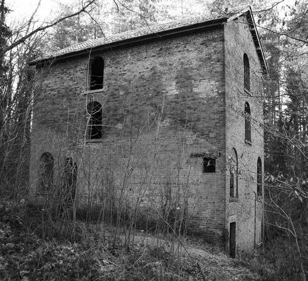
The late 19th century Seldom Seen engine house (above), in the Moss Valley west of Eckington, is one of the area’s hidden gems
Buildings are often older than you think
MATT HURFORD is a conservation and historic buildings consultant, based in Bonsall. Here he describes a typical day in his life to editor ROLY SMITH
Matt Hurford admits to being an “old school” historic buildings consultant. “I do enjoy producing hand drawings on site and using my old Bronica film camera,” he confessed.
A typical day for Matt, who was brought up in Derbyshire and is now based in the former lead mining village of Bonsall, might involve a morning site visit to inspect a building, then an afternoon spent researching the archives at the Derbyshire Record Office in Matlock. “But no two days are ever the same,” he says, adding “Unlikely discoveries are a regular occurrence.”
Take the visit to Plum Tree Cottage, a former farmhouse at Brund in the
Staffordshire Moorlands. “I was commissioned to produce a historic building report on the property,” said Matt. “I discovered that the support for the privy roof was actually the tombstone to Ellen Critchlow, who died in 1815 at the age of 51 and was the wife of John, the owner of the farm. So he could read her inscription while seated on the privy!”
On a couple of other occasions, Matt has been called in to assess buildings which turned out to be much older than initially thought. In the case of Throwley Barracks in the Manifold Valley, what at first glance appeared to be a 17th century service range had much earlier origins, with a crown strut roof of likely 15th century date, thus of regional significance. Lees Hall at Barlow, a stone-built house of 17th century date, concealed a timber-framed building which was probably erected during the late 15th or early 16th century.
I discovered that the support for the privy roof was actually the tombstone to Ellen Critchlow, who died in 1815 at the age of 51
And at Ivy Cottage in Greaves Lane, Ashford-in-theWater, Matt discovered what looked like a typical mid to late 18th century cottage had actually been first recorded on William Senior’s 1616 map of the village. “Many of these properties are far older than you think, with early buildings lurking beneath later frontages,” Matt explained.
Barns are fruitful places to trace the history of actual people who lived in a village. One in Gypsy Lane,
Alstonefield revealed graffiti recording “JD 1932”. Matt commented: “We know this must have been John Davidson, who farmed there at the time.” Another interesting example at Throwley reads “JC 1855”, likely to be a local character called Joseph Coxen who was documented as a labourer in 1851, a poacher in 1864 and “a brawler” in 1880. Matt has been involved in archaeology for over 30 years, graduating from the University of Manchester with a BA (Hons) in Ancient History and Archaeology and later from Nottingham with an MA in Medieval Archaeology. He has been employed as an archaeologist by the Universities of Nottingham, Leicester and Lancaster and was a dendrochronologist for a number of years, initially as a Research Assistant at the University of Sheffield, prior to becoming a freelance heritage consultant.
The frontage and north gable of Throwley Barracks; internal picture of the crown strut roof (inset left)
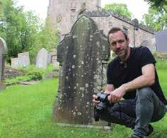
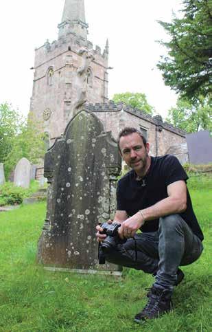
Matt working in the churchyard of St James, Bonsall
Plum Tree
Cottage, Brund, with the gravestoneroofed privy abutting the gable
Lees Hall Farm, Barlow (above)
The frontage and west gable of the Gypsy Lane barn, Alstonefield (above left)
Keeping time at Haddon Hall
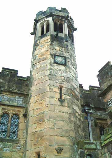
Built around 1455, the Bell Turret at Haddon Hall displays a “W” on the elevation seen when approaching the entrance to the Chapel. This is said to be an old English “V” for the family name of Vernon.
The staircase leading to the belfry rises from behind a door in the Chapel’s north wall and the bell chamber is accessed by carefully climbing the spiral of 31 well-worn, stone steps. A hole can be seen in some of the steps. These were to allow the bell-ropes to pass from the bells in the turret to the bellringer at ground level. Each hole would have been fitted with a wooden boss to allow the ropes to run freely and reduce chafing.
In the 15th century, the main purpose of the bells would almost certainly have been to call estate workers to and from rest to labour, as well as summoning them to church and to sound the alarm in emergencies. Time-keeping then would have been by means of a sundial.
Originally, two bells hung in the turret but in 1885, one was re-hung at the newly-built St Katherine’s Church, Rowsley, a village on the Haddon Estate. Its benefactor was Lord John Manners, 7th Duke of Rutland, who in 1862 added the mortuary chapel dedicated to his first wife, Lady Catherine. Although the bells may possibly have been made at Whitechapel, local historians consider it is more likely to have been at Taylors of Loughborough.
Ringing the bells caused a good deal of vibration to the structure and to minimise these effects, the clock was stopped during the winter months and the bells silenced. More recently some of the turret’s masonry has been restored by the estate’s stonemason and, to accelerate the development of a more established appearance, he applied a daub of yoghurt and cow dung!
It is estimated that 2,000 to 3,000 bats roost in the tower during the summer months, though these are believed to move elsewhere to hibernate for the winter.
Approximately half-way up the tower is a door which provided access to the Chapel’s rood screen, which was removed in the 17th century. By traversing the screen, the bellringer could see both the altar and the clergyman, and this enabled the operator to ring the bell at appropriate times.
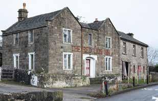
Papering over the cracks at Wensley
Renovations at a former Wensley pub have revealed a fascinating glimpse of yesterday’s news, as RICHARD POUGHER reports
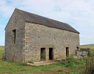
Between 2021 and 2023, TJC Heritage Ltd undertook a programme of archaeological building recording at the former Red Lion Inn, Wensley. The recording was requested by the Peak District National Park Authority (PDNPA) as a condition of planning consent, and the programme was developed in conjunction with the Authority’s Cultural Heritage Team and carried out in accordance with an approved Written Scheme of Investigation (WSI).
The site comprises a complex of six buildings with multiple phases of development from the early 18th century onwards. It provides an interesting insight into the development of a small homestead/smallholding, which expanded in the mid-18th century before being further developed into an early 19th century roadside inn, combining this function with the farmstead.
consumed by the previous owners and provide details of historic events in the general area.
As it was proposed to remove the wallcovering, and following discussions with the PDNPA’s archaeologist and the property owner, it was determined to take a sample for future analysis. A photographic record of the wallcovering was made prior to sampling and a strip, c.2m x 3m in size, was then removed.
The wallcovering represented a combination of documents dating from the 1850s as evidenced by sheets of newspaper dated 1849 and 1853. The use of paper directly applied to laths, rather than applying a plaster surface, is unusual and is likely to have been undertaken as a cost saving exercise. Further research into the treatment of internal stud walls in the Peak District National Park may reveal additional examples of this decorative technique
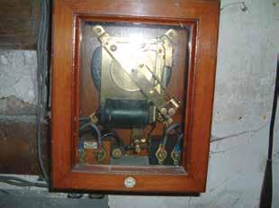
The first clock installed was a turret clock in the late 16th century. A hundred years later, in 1670, this was superseded by one of a later design which remained in position until 1925 when it was removed from its original position, restored by the 9th Duke and is now displayed in a glass case in the Haddon Hall museum. Except for the two wooden drums on which the weight ropes were wound, the clock frame and moving parts are all of wrought iron.
In 1926, the first electric clock was installed. This was a ‘waiting train’ clock built by Smiths of Derby. The brass and mahogany equipment is still in place in the main building, but no longer in working order. This system operated using two phases: a master clock or mechanism which sent a signal to a second clock situated remotely in the belfry. The clock is currently operated by a modern digital electrical mechanism.
The ground floor rooms were renovated in the mid-20th century, with additions including tiled surround fireplaces inserted into larger existing openings, red and green terrazzo tiled floors, and bar counters. In the south-west room, this had brushed steel side panels with applied leatherette beading and laminated vinyl top. Both bars retained taps for Guinness, and decoration included the familiar Guinness logo of three toucans applied to the north wall, each with two pints balanced on their beaks.
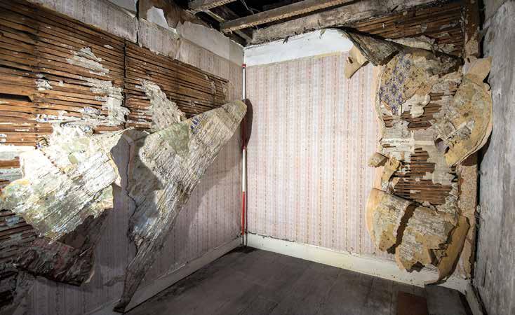
During the survey it was noted that walls of the southwest first floor room were not plastered, rather the laths were covered with sheets of newspaper and posters, and then multiple layers of wallpaper. This is a highly unusual practice, and it was considered that the layers of papers used are likely to contain historic information that would assist with dating its creation, the form of documentary material available/
Although the practice of covering walls with paper rather than plaster is unusual, the mid-19th century date of the material used is well understood, and numerous contemporary newspapers and adverts survive in archives. Further examination may still, however, be of interest in furthering our understanding of the development of the Red Lion Inn and the activities/interests of its occupants. As such it was recommended that sections of the paper be preserved for future analysis.
The Bell Turret at Haddon
STEPHEN COATES relates the timeless story of the clocks in the Bell Turret at Haddon Hall
The original turret clock
The brass and mahogany ‘waiting train’ clock
The former Red Lion Inn, Wensley
Wallpaper being stripped away to reveal the newspaper linings
‘Bricking it’ in Matlock
Collaboration between commercial archaeologists, their brick specialist and a local historian revealed a long-forgotten brickworks in Matlock, as MARTYN THOMAS, DAVID JOHNSON and ALAN PIPER explain
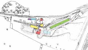
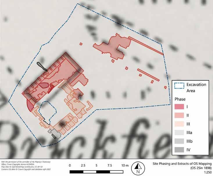
An excavation on land off Chesterfield Road, Matlock, was undertaken between November 2023 and January 2024 by MAP Archaeological Practice of behalf of Homes by Honey, in advance of their housing development, as required by Derbyshire Dales District Council as part of the planning process for the site.
A previous scheme of trial trenching had revealed a brickbuilt structure related to the brickfield depicted on early OS
maps. The aim of the excavation was to understand the extent and form of the surviving structural remains.
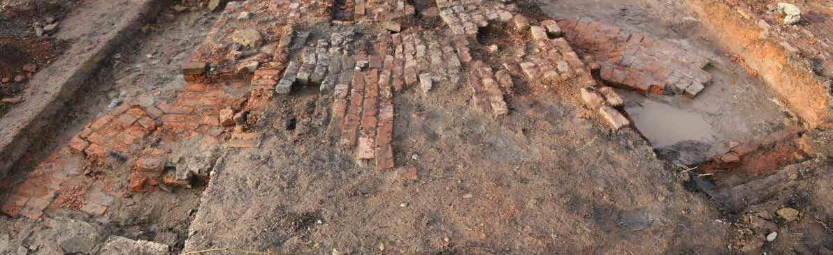
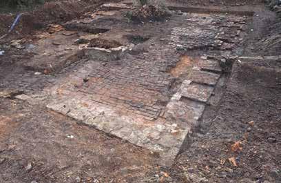
Three distinct phases of brick kiln were identified, the earliest represented by the brick footings of a beehive-style kiln, 1m wide, forming a circular structure 7m in diameter.
A row of bricks three courses deep appeared to form part of a cross through the footings. These may have been laid down as part of an initial brick cross, to aid the construction of the circular structure.
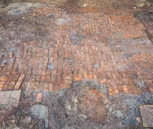
The second phase of kiln, built directly over the top of the earlier beehive kiln, was a rectangular Scotch kiln, measuring 11.3m long and 4.9m wide. Ten fireboxes were constructed into each of the long sides, where the fires to bake the bricks would have been, and the hot air drawn into the kiln.
A single-coursed brick floor survived between the walls, showing evidence of heat damage and repair work.
This was later replaced with a smaller Scotch kiln to its southeast, which measured 10m long and 4.9m wide, with
southeastern side beyond the excavation limits.
Along the northern edge of the excavation were the remains of a hack shed, where the wet clay bricks were stored and dried prior to firing. The building was at least 6m wide and 18m long, made up of a brick floor and stone bases to pillars, which would have supported a low roof, and louvred timber walls.
No artifacts were found which provided dating evidence for any of the kilns, but there is documentary evidence about the date and ownership of the brickyard. Landowner William Young was making bricks there in 1871, according to the census data. OS maps show that the earlier Scotch kiln was in use in 1876-9, but that by 1897 the works were “disused”.
seven fireboxes built into each long side. The brick floor showed less heat damage, indicating it saw less use than the earlier kiln.
A coal store was built along the northwestern wall of the kiln, and most likely would have had a counterpart on the
The large size of the hack shed and the development of three kilns of two different designs point to large-scale production, expansion to meet a growing demand for bricks and/or an intention to remain operational for the long term, but William had sadly died in 1890. Although it is possible that the business was carried on for a while for his widow by William Wilkinson, a brickmaker who was living close by in 1881 and 1891, it seems likely that the brickyard only operated within a period from the mid-1860s until the mid1890s.
The site is now buried, with some protection for the later kiln, under the access road to the development.
Alan Piper
Plan of site, overlying 1898 OS Map
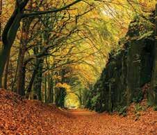
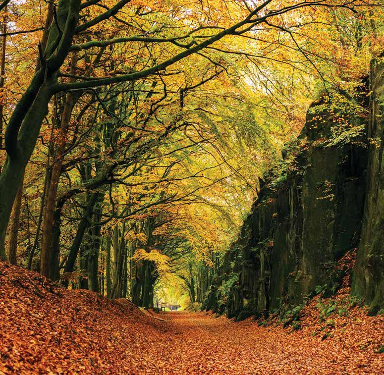
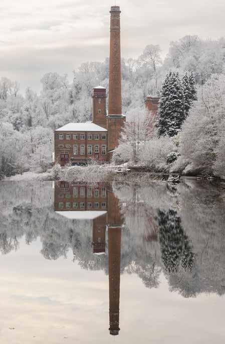
High Peak Trail, Autumn by Michelle Jackson. The High Peak Railway, built in 1830, was one of the earliest railways in the country. This photo was taken on the Sheep Pasture Incline at Cromford
‘A
living museum of industrial heritage’
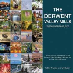
ASHLEY FRANKLIN describes the story behind a new book on the Derwent Valley Mills WHS
When I came to live in the Derwent Valley in the late 1970s, I admit to my shame that I paid little heed to the area’s history. Even though I lived in a late 18th century cottage built by millowner Jedidiah Strutt on The Chevin in Milford, it wasn’t until UNESCO conferred World
Heritage Site status on the valley in 2001 that I realised I was residing in a living museum of industrial heritage and that my cottage, village and valley were of “Outstanding Universal Value to Humanity.”
Having previously broken the ice at parties by declaring that Timothy Dalton of James Bond fame “lived down our road” (the truth was that Tim’s parents lived in a house a mile along The Chevin), my new ice-breaker became: “Without Milford, there would be no Manhattan.” I learnt that William Strutt had ensured that the mill at Milford – along with a few
in Belper – was iron framed and fire-safe, paving the way towards the building of skyscrapers.
From 2014, I immersed myself further in the valley’s heritage as official photographer for the Arkwright Society, and was commissioned to produce the first photo book of the Derwent Valley Mills World Heritage Site. After nearly 10 years hard work, that book, The Derwent Valley Mills: A photographic record, was finally published (see
Clockwise from top left: Via Gellia Mill by Ian Daisley. Professional photographer Ian Daisley assisted Ashley with the book project, taking photographs and designing the book. Oddly, although this mill was built by Sir Richard Arkwright, it’s not officially on the Derwent Valley Mills list
Masson Mill Frozen Reflection by Steve Watson.This was the first time the Masson Mill’s reflection was as frozen as the elements around it
Water Power, Cromford Mills by Ashley Franklin. Of the 477 images in the book, 275 are by Ashley. “This image is one of my favourites,” he says, “as it shows part of Sir Richard Arkwright’s original mill complex looming above Bonsall Brook, the water source he utilised to power his machines.”
review on p32). The book was boosted by an appeal to local photographers to capture the Derwent Valley, and the work of 50 are featured.
I’m proud of this rich, diverse photographic record as it not only highlights the historical significance of the valley, but also encapsulates its communities and its bountiful biodiversity. The Industrial Heritage section provided the thrust of this book, commemorating the valley not only as a cradle of the Industrial Revolution, but also as the birthplace of the factory system.
Overall, this book celebrates an environment where mills, factories, workshops, houses and landscapes have been variously restored, rejuvenated and preserved.
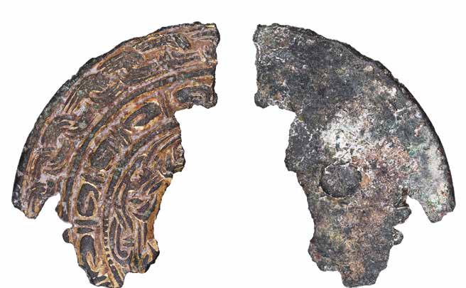
Possible harness link to Sutton Hoo
MEGHAN KING, Derbyshire Finds Liaison Officer, describes the fragment of a possible horse harness mount found in Elvaston
An interesting find from the past year, found in Elvaston, South Derbyshire and recorded on the Portable Antiquities Scheme database, is this fragment of a copper alloy mount, discovered by a metal detectorist. The mount fragment dates to the early medieval period, likely between AD 570 and 670; the complete PAS record can be found here at DENO-B595FC (https://finds.org.uk/ database/artefacts/record/id/1150529).
The fragment comprises just over a third of the mount’s original circular form and is broken on its two inner edges in worn irregular breaks. Its outer face is adorned with concentric bands of chip-carved and incised decoration in shallow relief. The outermost band includes cable link decoration, while the central band contains a repeated looped pattern which probably represents animal heads. The remains of the innermost decorative panel shows interlaced abstract forms, which are also likely to be zoomorphic. These bands of decoration are separated by thin, raised ridges and grooves. There are traces of gilding present throughout the
decoration, as well as areas of possible discoloured enamel. Kevin Leahy, PAS National Finds Adviser for Early Medieval Metalwork, commented that the iconography on the outer face of the fragment generally corresponds to Style II animal decoration. However, the central band appears to be earlier in style; this perhaps indicates that the object was a transitional piece.
At the time of writing there were only 14 other examples of this kind of mount recorded on the national PAS database, with this mount being the second example found in the East Midlands. The first regional example recorded was found in Lincolnshire and while it is an almost complete example, it features fewer decorative elements than its Derbyshire counterpart. The Lincolnshire record (LANCUM-F4CFCC) notes that mounts of this type are often known as Allington Hill-type mounts, as their best parallels are in a group of mounts found at Allington Hill, Cambridgeshire. One is currently on display in the Ashmolean Museum in Oxford and another is in the Museum of Archaeology and Anthropology in Cambridge.
Interestingly, since the Allington Hill discovery, a similar mount was found on the bridle band of the horse buried in Mound 17 at the famous Saxon burial ground Sutton Hoo in Suffolk, therefore it is possible that all of these mounts were originally on horse harnesses.
The Elvaston find highlights how even fragments of objects can be significant discoveries and, through reporting to the Finds Liaison Officer and recording on the PAS database, they can add to the archaeological record of Derbyshire.
If you would like to find out more about the Portable Antiquities Scheme, or have found any items that you would like recorded, please contact Meghan King, Finds Liaison Officer for Derbyshire and Nottinghamshire, on 01332 641903 or at meghan@derbymuseums.org.
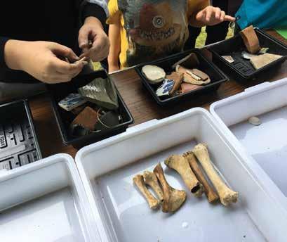
Derbyshire Scouts are prepared for anything!
Derbyshire Scouts Archaeology goes from strength to strength, as MORGAUSE LOMAS reports
The Derbyshire Scout Archaeology team inspires young people to engage with their local heritage all year.
Now in our fourth year, over 30 groups have enjoyed our popular Introduction to Archaeology evenings, from Squirrels aged 4-6 years, to Scouts aged 10-14 years.
We have now awarded an amazing 1,600 badges to Scouts within Derbyshire and beyond, including badges to Cambridgeshire, Leicestershire, Nottinghamshire and Shropshire.
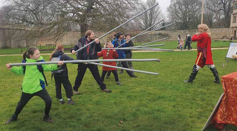
Our Youth Committee visited Cromford Mills, where they learnt about cotton production in the Derwent Valley. They used the cotton weighing scale and found that the youth committee weighs the same as 406 pineapples! At Bolsover Castle, they learnt about the Cavaliers and Roundheads of the English Civil War, even having a go at a pike drill.
The youth committee continues to contribute ideas for future ventures. They also considered the question, ‘Why should we study archaeology?’ and their recorded answers were posted as video clips on our social media accounts, hopefully sparking a new interest in archaeology in others.
Our 2024 dig weekend was held at Willesley, now in Leicestershire but formerly an ‘island’ of Derbyshire beyond the county boundary. Once home to Willesley Hall, the site is now a Scout campsite, the derelict hall having been demolished in the mid-20th century.
One hundred young people attended, getting hands-on with trowels in the trench, as well as conducting a resistivity survey, using metal detectors, and learning how to identify and classify finds.
Our aim was to find the 18th century hall. We did this, and more – we also found brickwork from the earlier Tudor hall. At the time of writing, experts are analysing some of the bricks to determine the date of this building. A shard of
green glazed pottery hinted at earlier occupation, and our detectorists uncovered some fascinating finds, as well more than 50 tent pegs lost by generations of Scouts.
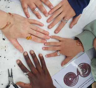
We have also taken archaeology to three multi-activity Derbyshire Scout camps, where our activities included coin timelines, sandbox ‘test pits’ and prehistoric-style charcoal drawing. At one camp, Scouts made Iron Age bracelets and rings using jewellery wire, and we set ourselves the challenge of building, over just two days, an Iron Age roundhouse – an endeavour we almost achieved. The lessons learnt will help us to do even better at our own Experimental Archaeology camp next July.
Please contact us if you are interested in joining our team. Whether your background is in archaeology, Scouting or neither, the only requirements are enthusiasm and a desire to inspire young people to explore Derbyshire’s diverse archaeological heritage.
Find more information at: www.derbyshirescouts. org/activity/Archaeology or search Derbyshire Scout Archaeology on Facebook, Twitter, Instagram and YouTube.
Scouts have a go at a pike drill at Bolsover Castle (top)
Displaying replica Iron Age rings made from jewellery wire (left)
The Elvaston fragment
The Lincolnshire mount
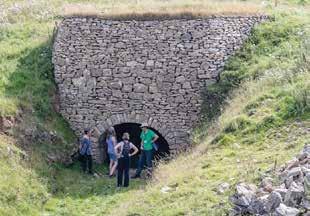
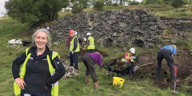
Historic copper mine no longer at risk
FIONA STUBBS describes the conservation of Ecton balance cone – and its wider significance to one of the country’s most important historic mining sites
It was once one of the most important copper mines in Britain, renowned for its use of cutting-edge technologies and its generation of considerable wealth.
Today, Ecton Copper Mine in Staffordshire again stands proud after conservation of the unique Ecton balance cone, resulting in the entire, nationally important, site being removed from the UK’s Heritage at Risk Register.
The project was made possible thanks to grants totalling £145,000 through the Defra-funded Farming in Protected Landscapes programme, administered by the Peak District National Park Authority.
Funding allowed a multi-disciplinary feasibility study to understand the structural integrity of the Ecton balance cone, its archaeological complexity and its importance for wildlife.
The balance cone is a complex structure, both above and below ground. A scheduled monument, falling within two Sites of Special Scientific Interest (SSSI), Ecton was once the deepest mine in England, using cutting edge 18th century technology to extract copper ore from depths of up to 300 metres below the River Manifold.
The cone housed a counterbalance to support some of the weight of the winding rope and reduce the load on the Boulton and Watt steam-powered winding engine which, in 1788, was only the sixth ever commissioned in the world.
At the height of its 18th century success, profits made by its then owner, the fifth Duke of Devonshire, are said to have financed the building of the magnificent Crescent in Buxton.
Archaeologists from the Peak District National Park Authority worked alongside partners, including Ecton Mine Educational Trust, Ecton Hill Field Studies Association and Historic England to guide the conservation project.
Anna Badcock, cultural heritage team manager at the Peak District National Park Authority, said: “This is a perfect
example of a complex site that delivers important benefits for cultural and natural landscapes and really shows what can be achieved through working in partnership.
“It is the final piece in the jigsaw to get this site removed from the Heritage at Risk Register. Previous work – led by the National Trust and the partnership – included repair of the engine house and powder house.”
A celebration event marked the successful conclusion of the project. Authority chief executive Phil Mulligan cut a ribbon and mining songs were performed by members of two choirs – West Bridgford Social Singers and Everyone Can Sing – led by musical director Simon Thompson.
Mining at Ecton Hill dates back over 3500 years, with copper and lead deposits worked from the Bronze Age to 1891.
New interpretation is planned for the Geoff Cox Centre on Ecton Hill and at nearby Hulme End – at the start/finish of the Manifold track – to improve people’s understanding of the history of lead and copper mining here and elsewhere in the Peak District.
For over 20 years, the interests of the Ecton Copper Mine have been overseen through the collaborative efforts of a partnership of several organisations, with landowner support. The partnership includes the Ecton Mine Educational Trust, Ecton Hill Field Studies Association, Peak District National Park Authority, Historic England, National Trust and Natural England.
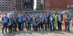
Family archaeology event at Castleton
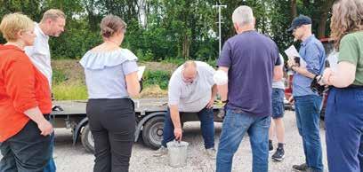
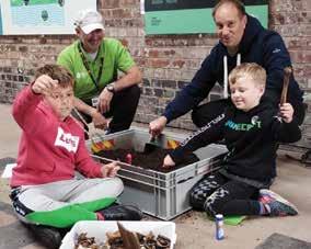
The Peak District National Park’s contribution to last year’s national Festival of Archaeology was a family event at Castleton, as ALISON RILEY reports
Afree event for families fascinated by how people lived in the past was provided by the Peak District National Park at Castleton Visitor Centre in July last year.
The drop-in event included archaeological fun and activities for all the family to learn about the archaeology of Castleton and the Peak District. National Park archaeologists were there to answer questions.
Senior conservation archaeologist Natalie Ward said: “We’re glad families came along and joined in the hands-on
Showcasing Peak District heritage
Heritage Open Days, run in September, are England’s largest community-led festival of history and culture, involving thousands of local volunteers and organisations.
Every year they bring people together to celebrate their heritage, community and history. Stories are told, traditions explored and histories brought to life.
Last year’s events in the Peak District included:
• Exploring the historic limekiln and brick kiln off the High Peak Trail near Minninglow
• Magpie Mine, Sheldon: an opportunity to learn more about this historic Derbyshire lead mine, including guided tours of the mine surface
• Pollen in a Peak Bog: A Community Archaeology Project
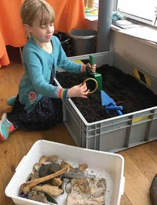
activities and games. Kids delved into the dig pits to see what they could uncover, made their own Arbor Low stone circle, and made a Bronze Age pygmy pot which they could take home.
“People were able to learn about the recent discoveries of Castleton Historical Society and find out about the heritage they have unearthed from beneath our feet.
The National Park archaeologists were joined by Meghan King, the Portable Antiquities Scheme’s Finds Liaison Officer for Derbyshire and Nottinghamshire, who showed and identified finds and answered questions.
The event was organised by the Peak District National Park as part of the Council for British Archaeology’s Festival of Archaeology, to help celebrate cultural heritage and encourage more people to get involved in archaeology.
by the Tudor Farming Interpretation Group at the Dove Valley Activity Centre, including Meet the Anglo-Saxon Monk and Meet the Archaeologist.
For more events and booking details, go to: https://www.heritageopendays.org.uk
Hillside view of the Ecton balance cone
(above left) Making discoveries in the dig box
Exploring the limekiln, Minninglow
(above) Examining archaeological finds
National Park archaeologist wins award
APeak District National Park archaeologist was chosen by the Council for British Archaeology (CBA) as the 2024 Community Archaeologist of the Year in the Marsh Community Archaeology Awards.
These annual awards celebrate the people’s dedication and the outstanding contributions of archaeology projects which create social, cultural and environmental benefit to communities in the UK. The Community Archaeologist of the Year award recognises an individual who has voluntarily or professionally gone above and beyond to make a difference.
Dr Catherine Parker Heath, community and conservation archaeologist for the Peak District National Park, said she was “thrilled” by the award. Catherine received the award at Castleton Visitor Centre during an Archaeology Activity Day
AAwhere she was working for this year’s Festival of Archaeology. Presenting the award, David Booker, Marsh Charitable Trust Ambassador, said: “Catherine has been recognised for her exceptional dedication to community engagement and volunteer involvement. Through her work, Catherine shares her love of archaeology with people of all ages and backgrounds, enabling them to actively participate in projects across the National Park.”
Neil Redfern, Executive Director of the CBA, said:
“Catherine places a strong emphasis on skills development, teaching volunteers valuable techniques such as surveying, photography, drawing, and digital mapping with ArcGIS. Her projects not only educate but also empower participants, fostering a lasting appreciation for archaeology and conservation.”
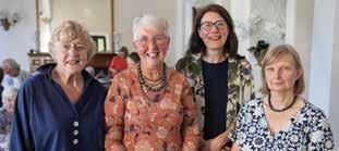
warm ‘thank you’ to Ros
celebration afternoon tea to mark Ros Westwood’s 26 years as curator and manager at Buxton Museum and Art Gallery was held in September in the Cavendish Room at the Buxton Palace Hotel.
Warm tributes to Ros’s outstanding service were paid by Anita Hollinshead, former Regional Collections Advisor for Museums Development East Midlands, and Lindsay Crowe, chair of the Friends of Buxton Museum.
Under Ros’s leadership, visitor figures to Buxton Museum doubled, with the county receiving local, regional and nationally recognised awards for its exhibitions and events. When she took over the running of the museum and art gallery in Buxton, it had lost its recognised Museum Association status, but Ros quickly turned this around, and not only was its membership status re-established, it also achieved Arts Council accreditation.
Ros was at the forefront of the redevelopment of Buxton Museum and Art Gallery, which transformed the technology
and opened the museum up to the world through the internet. Derbyshire County Council closed the museum in 2023 due to dry rot, and work is still on-going to try to find a home for its important collections. Martha Jasko-Lawrence has been appointed Museums Manager, Libraries and Heritage, by Derbyshire County Council.
Ros, a fellow of the Museums Association, was recognised for her services to culture in the East Midlands by receiving the MBE in the Queen’s New Year’s Honours List in 2019.
From paved path to pollen in a peat bog
CATHERINE PARKER HEATH, Community and Conservation Archaeologist for the National Park, gives an update on the work of the cultural heritage volunteers
Our cultural heritage volunteers have been busy again this past year, carrying out a variety of important tasks. Scheduled monument monitoring has continued with volunteers visiting sites ranging from Bronze Age barrows and Roman forts to industrial sites. The more experienced volunteers also introduced several junior rangers to this task in May, visiting several scheduled monuments in Hope. Where monitoring had identified issues, volunteers were able to step in where they could, such as bashing invasive bracken at Hob Hurst’s House and the Warren Romano-British settlement.
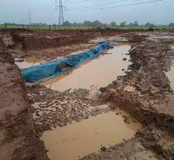
Volunteers also carried out what we call ‘an enhanced condition survey,’ accurately recording many areas of erosion on a vulnerable lead mining site, enabling Scheduled Monument Consent to be granted. They then gave valuable assistance to repair the damaged earthworks, conserving the monument for the foreseeable future.
We also finally finished the recording of Winster’s historic paved path thanks to the hard work of 15 dedicated volunteers over the past couple of years. We now have scale drawings detailing the condition of the paved path before restoration work started in the autumn. To accompany the drawings, volunteer Merrick Iszatt has written a report putting the path it into its historical context.
One task that was revived following a hiatus due to COVID was condition surveys of our listed buildings. We have over 2,500 listed buildings in the National Park and after completing training in June, volunteers have now begun to tackle a large backlog.
Our volunteers bring with them a wide variety of skills and we are very lucky to have two who are a dab hand at
creating 3D models: Richard Knisely-Marpole took his drone to Tissington and created a fabulous 3D model of what is believed to be an historic silo, prior to its restoration, and David Moore helped out the Tudor Farming Interpretation Group (TFIG), printing 3D models of pollen for their ‘Pollen in a Peat Bog’ Heritage Open Day in September, which celebrated their very successful ‘Pollen Project’.
A small group of our volunteers ran their own open day on the High Peak Trail at Minninglow, which focused on the limekiln and brickworks. The volunteers braved the weather over the weekend in September and provided tours to enthusiastic visitors. Every visitor said how much they had enjoyed it and how informed the volunteers were. The volunteers certainly put a lot of time and effort into researching the structures leading up to the event. One visitor was chair of the British Brick Society, Mike Chapman, and the volunteers are now set to co-write an article to be published in the society’s quarterly journal.
One of our newest volunteers Kristy designed a new activity trail around Castleton at the Festival of Archaeology day at Castleton Visitor Centre in July, encouraging youngsters to look carefully at some of its historic buildings. Volunteers were also on hand to provide activities at the Big Volunteering Weekend at Miller’s Dale Station in September, where they celebrated what they had achieved over the past year.
We’re hoping to expand our cultural heritage volunteering offer in the future, so if you are interested in being involved, watch this space!
Dr Catherine Parker Heath with volunteers at Dale Mine
Sheila Martin, event organiser; Ros Westwood; Anita Hollinshead, and Lindsay Crowe (left to right) Picture: Nick Lockett
Visitor holding a 3D model of campion pollen at the TFIG’s open day (far left)
Catherine (left) with volunteers at Minninglow limekiln (above)
3D model of the Tissington silo (left) Picture: Richard KniselyMarpole
From Medieval mouthwashes to Mesolithic fishing
Peak District Young Archaeologists’ Club has had another busy year, as MARTHA JASKOLAWRENCE reports
Young Archaeologists’ Clubs (YAC) provide opportunities for children and young people aged eight to 16 to explore their interest in archaeology. National support is provided by the Council for British Archaeology, but each local club is run by volunteers. YAC members get involved in all sorts of activities, including visiting and investigating archaeological sites and historic places, trying out traditional crafts, taking part in excavations, and lots more.
Peak District YAC has had another busy year of activities. It is run by Branch Leader Martha Jasko-Lawrence, now as part of her role at Buxton Museum and Art Gallery, though the club meets at different locations around the county. She is supported by Branch Assistants Michelle Burpoe and David Matthews.
The club often makes use of resources on YAC website to find ideas for sessions. For two sessions in the past year, the leaders used a resource pack on woodland archaeology. Initially we visited Queen’s Park in Chesterfield to identify trees and used maps to find woodland-related placenames in the Peak District.
For a later session, we spent a rather rainy morning exploring Grin Low Woods in Buxton. We looked for signs of woodland management and used information from the Historic Environment Record to spot the remains of lime kilns.
Industrial history was also explored on a trip to Kelham Island Museum in Sheffield. Members were able to handle items of industrial archaeology excavated in the city and understand that archaeology is not just Romans and prehistory.
We were once again able to take part in the University of Sheffield and Castleton Historical Society’s excavations at Castleton, this time exploring the site at Cotton Mill Field. Members experienced trowelling and finds processing after an introduction to the site by Colin Merrony from the University of Sheffield.
Indoor sessions have included finding out about the salt extraction industry and attempting to extract salt from a saline solution. Another topic was exploring dental hygiene through time and making mouthwashes from medieval and 1920s recipes. The experimental conclusion was that the medieval mouthwash of grape juice (a child-friendly alternative to wine), fresh mint and ground pepper was just about OK, while the 1920s recipe of water, ground fennel seeds, sugar, salt and peppermint oil was not to be tried again!
As well as experimental archaeology, craft-based sessions allow the members to explore a subject through creative activities. A session on Mesolithic fishing involved weaving models of fish traps from straws. The Vikings were investigated through making money pouches and Viking helmets.
The club always welcomes new members and adult volunteers. The only qualification needed is an interest in archaeology. To find out how to join as a member or volunteer, visit www.yac-uk.org/clubs/peak-district.
Shedding a laser light on landmarks
ROSEMARY ANNABLE of the Derbyshire
Archaeological Society reports on its use of geospatial surveys on two of Derbyshire’s most famous landmarks
Geospatial survey, in the form of terrestrial laser scanning or photogrammetric surveys, has recently been employed by the Derbyshire Archaeological Society (DAS) on two very different sites in the county. It forms a valuable component of the recording, analysis and understanding of cultural heritage, as well as providing a key point-in-time record for the long-term conservation management of sites.
The remains of the medieval bridge chapel at Cromford were given to the Society in 1943 by the owner, Charles Payne, and the furnaces at Morley Park ironworks were transferred to it in 1986, after restoration work by the Derbyshire Historic Buildings Trust.
To date the two sites have been difficult to record; the two blast furnaces at Morley Park because of their size, and the remains of the Cromford chapel due to its location, where important parts of the structure can only be seen from the River Derwent.
In order to record and monitor their condition, DAS commissioned MSDS Heritage to undertake a geospatial survey of both properties. The work was undertaken in February 2024, comprising terrestrial laser scanning and a photogrammetric survey of the extant historic fabric at Morley Park, and of Cromford Bridge, of which the chapel is part, and which has never been recorded.
The principal aim of the terrestrial laser scanning surveys was to create an accurate survey dataset of the extant remains of both sites that can be used to aid
their long-term conservation, as well as providing the basis for detailed drawings to form a backdrop for the analysis of the phasing and construction of the fabric. The aim of the photogrammetric surveys was to create 3D photographic models to go online to facilitate the visualisation and understanding of the sites in a virtual environment.
As both sites are Scheduled Ancient Monuments, the extent of the surveys was defined by the degree of exposure of the fabric. However, the creation of an accurate, georeferenced survey means that future surveys of additional areas of the sites can be added later.
It is hoped that future surveys may enhance this record using geophysical survey in the form of ground penetrating radar and photogrammetric surveys of areas exposed during future archaeological or conservation works. In the case of Cromford, where archaeological excavation in the chapel in 1951 revealed the abutment of an earlier bridge on a different alignment, it might include the use of marine geophysics or an underwater drone survey to enhance the record of the below-water parts of the structure, highlighting the complex history of the river crossing that gave Cromford its name.
Manor Adventure Willersley Castle and the members of Cromford Fly-Fishers’ Club kindly facilitated access for the survey which was funded in part by a bequest to the society from Mrs Margaret Mallender.
For further information about the Derbyshire Archaeological Society, its activities and publications see www.derbyshireas.org.uk
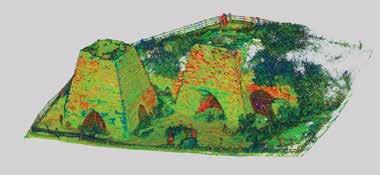
Equipment being demonstrated by MSDS for DAS members (Rosemary Annable)
Screenshot (below) of the Morley Park furnaces (MSDS) Drone image (inset left) of Morley Park furnaces (MSDS)
Saving Derbyshire’s heritage
ALLAN MORRISON, Trustee/director of the Derbyshire Historic Buildings Trust describes the Trust’s latest project
Flushed with the great success of rescuing Wingfield Station, the Derbyshire Historic Buildings Trust is starting on a two-part project to:
• find future Buildings at Risk priority rescue cases
• develop the Trust’s Educational and Training initiatives in Heritage Skills.
A generous grant from The National Lottery Heritage Fund enabled a start last year with the employment of two project officers to lead on the organisation and promotion of the two parts.
The Buildings at Risk project will begin by engaging groups of local volunteers in each district to carry out the survey building-by-building, and to record their condition on a smartphone app.
Live, on-site training projects in heritage building skills will be organised and managed via the Trust’s own skilled advisers, for young learners, apprentices and mature tradespeople alike.
The Heritage Development Officer (HDO) will support the Trustees to achieve their mission to identify buildings at
risk and work with others to propose sustainable new uses.
The HDO will also help to ensure the DHBT becomes a more resilient organisation that will save, sustain, and champion vulnerable heritage buildings in Derbyshire for the benefit of local communities.
A key aspect of the HDO’s role is to work in partnership with representatives from the West Midlands Historic Buildings Trust (WMHBT) to test and develop their Buildings at Risk app, which they have commissioned following a Capacity Building grant from Historic England.
The app will be used in the pilot project in at least two areas of Derbyshire (Amber Valley Borough Council and Derby City), ahead of a county-wide survey, and the post holder will work with stakeholders, including Derbyshire County Council, to explore the options for how the gathered data will be best stored and shared.
The testing of the app will involve recruiting, training and managing volunteers who will undertake the buildings at risk surveys in the agreed areas. From this work, local ‘heritage at risk’ registers will be created.
The Heritage Training and Skills Coordinator (HTSC) will support the Trustees to achieve their mission to inspire people by sharing knowledge through the DHBT Academy that will enhance the care of historic buildings in Derbyshire. The HTSC will be working towards DHBT’s vision to be the source of knowledge and centre for coordinating the rescue and care of Derbyshire’s built heritage.
The HTSC will also undertake detailed research and development work to devise a formal and replicable strategy that will ensure traditional building skills training is incorporated into all DHBT’s future capital projects. They will identify potential partners and establish roles, responsibilities and resources based on an understanding of the needs of the workforce and the local community.
The Trust hopes that readers of ACID will be enthused to come forward as volunteers to help with the field surveys; you don’t have to live in Amber Valley or Derby City to help.
If you are interested please contact the HDO, Anna Cluley by email on anna@derbyshirehistoricbuildingstrust.org.uk
Database beyond the grave
CATHERINE
COTTERILL of the Bolsterstone Archaeology & Heritage Group describes its graveyard recording project
It all began with the Discovering England’s Burial Spaces (DEBS) Project. DEBS was an Historic England funded project based at the University of York and the Archaeology Data Service. A couple of our members became interested in the project and wondered if it might be something we could undertake in the graveyard of St Mary’s Church, Bolsterstone. The answer was a resounding “Yes”, and the work began.
The aim of the project is to combine the Church Burial Record, a recent local historian’s project, and our detailed records of memorials, which are linked to the actual plots. Our results will be used to populate a database which would be used by the church and enable them to support relatives searching for where their ancestors are buried.
Volunteers were invited to a launch, followed by our first working session. We used recording sheets devised by Harold Mytum from his Recording and Analysing Graveyards practical handbook from 2000. For our purposes, we only focussed only on the size, materials, inscriptions and designs
of memorials. Armed with clipboards, pencils, toothbrushes, water and tape measures, we began the long process of collecting information from each of the 4000-plus plots. That was in September 2022 and we are still going.
Wet weather and fastgrowing undergrowth make the uneven surface of the graveyard an unsafe place to move about, so two years down the line, we have unfortunately completed less work than we would have liked. We are however indebted to the church grass cutting team who have worked hard to clear spaces for us and the volunteers who provide coffee and cake during our working days.
New volunteers are always welcome. Please contact Bolsterstone Archaeology and Heritage Group or St Mary’s Church, Bolsterstone if you are interested in joining us or would like further information. Email us at: bolsterstoneahg@gmail.com or take a look at our website: https://bolsterstoneheritage.weebly.com/
New display of archaeology at Derby
Derby Museums has an opportunity to completely re-display its archaeology gallery for the first time in about 30 years.
After a successful funding application to The National Lottery Heritage Fund, the museum team will be working with local communities, museum visitors and partners in Derbyshire archaeology to define a new way forward for the gallery, which will open around November 2025.
Located in the Museum and Art Gallery, the current archaeology gallery gives a chronological overview of historical periods from prehistory up to the medieval period, illustrating them using key sites and events in Derby’s archaeological past. Unfortunately, today the displays are dated and don’t reflect recent research into the archaeological record of our area.
In its new form, we want to broaden the voices and perspectives in the archaeology gallery and increase the access to and engagement with our collections, and archaeology more widely.
This re-display will run in conjunction with a refreshment of the adjacent Natural Sciences gallery (‘Notice Nature, Feel Joy’) and may involve some cross-over between the two collecting areas as we explore the themes and stories we want to tell.
The museum hopes to work in a collaborative way with visitors, local communities and people already involved in Derby’s archaeology community, from students, to detectorists, interested amateurs to published experts, and everyone in between.
We are at the beginning of this project and want to build relationships with people and explore with them the best way to display our collections and the stories that they tell us about our lives.
If you are interested in finding out more, please contact Derby Museums through Sadie Scott (sadie2@ derbymuseums.org) or Cameron Black (cameron@ derbymuseums.org). We look forward to hearing from you.
The Bretby Art Pottery shop at Swadlincote is a building at risk
St Mary’s Church, Bolsterstone
Derby Mueums is re-displaying its archaeology gallery
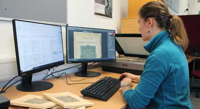
The Hunter goes digital
ANNA BLOXHAM of the Hunter Archaeological Society, explains how it is digitalising its journal
The Hunter Archaeological Society, founded in Sheffield in 1912, is a long-running society open to anyone interested in the archaeology, history and architecture of South Yorkshire and north-east Derbyshire. The society was named in recognition of the work of antiquarian Joseph Hunter in researching and recording the history of the region in the first half of the 19th century. It now has around 180 active members and runs a lively programme of talks, walks, site monitoring, and heritage activities. Since 1914 the Society has published original research and new discoveries from across the region in its journal Transactions of the Hunter Archaeological Society. The Transactions have long been a key publisher of local excavations, heritage, and historical research, much of which cannot be found elsewhere. As the early volumes are now more than 100 years old – and often difficult to get hold of –the Society has embarked on an ambitious digitisation project with the aims of preserving the complete back-catalogue for the future and making the contents more widely accessible. This project is being carried out in collaboration with the University of Nottingham’s Digital Transformations Hub
(DTH), a resource centre that provides access to equipment and expertise in digital media and methods. Each year DTH staff support two postgraduate research associates (RAs) to develop digital skills and gain work experience, and train around 30 undergraduate volunteers to participate in collaborative heritage projects – often with external groups such as the Hunter Archaeological Society.
On the Hunter Digitisation Project, student volunteers are supervised by RA Abigail Spanner and gain skills capturing high-quality images of the Transactions, adjusting these in editing software, creating searchable PDFs of journal articles, and cataloguing the material to provide searchable information about each article (known as metadata).
Abigail explained the technical process: “We start off by taking a 2D scan of the journal, one page at a time, using an A3 flatbed scanner. These scans are captured in TIFFs, a high-resolution archive-standard image format, so the journals are backed up permanently in case anything happens to the PDFs or physical copies. Then we tidy-up, straighten, and crop the scans, converting these adjusted images into PDFs for each complete article using Adobe Acrobat Pro. We run the PDFs through a process called Optical Character Recognition (OCR). This turns the images into a readable text format, from which you could – for example – copy and paste sentences, highlight sections, or search for specific terms. Once this process is complete, and any errors have been corrected, the Transactions have become a searchable PDF ready to use.”
The goal of this work is to make all volumes freely available online to anyone who wishes to access them. To support this, a new Society website will be launched in 2025, where access to the searchable digital volumes will be available. For more information about the Society and upcoming events, our current website can be found at: https://sites.google.com/site/hunterarchaeologicalsociety
Double celebration for Bakewell museum
Bakewell’s Museum Manager MARK COPLEY looks forward to an exciting year in 2025
Bakewell Old House Museum celebrated its 65th anniversary last year, and coincidentally, the Bakewell and District Historical Society, which runs the museum, also celebrated its 70th anniversary. Luckily, there is no such thing as too much cake, especially at a volunteer-run organisation such as the museum!
Reflecting on last year, we had a brilliant 2024. With the help of UKSPF Community Resilience Grant, we were able to employ Kelsey Power as Museum Assistant, and therefore open the museum seven days a week. This has resulted in greater audience numbers than before the pandemic.
A significant part of the increase in visitors was due to our Treasured Quilts: Warmth and Wealth exhibition. The exhibition showcased several exquisitely-made local quilts from Georgian era onwards, highlighting the families’ stories and fascinating history behind coverlet and quilt making in the region and country.
We also had pop-up community displays by the Over Haddon History Group and the Peak Rail archives team, which looked at Bakewell Station.
This year, we partner with the Level Centre in Rowsley. Their Youth Collective is going to create an absorbing exhibition based on the museum’s stories and their Derbyshire experiences. The Chesterfield Embroiderers’ Guild is also providing an exhibition – they have spent the last year creating items in response to our stories and
artefacts. These are beautifully designed and constructed, and visitors will encounter them as they wander around the museum.
The Tudor hall is now completely open and visitors love to dress up in Tudor-style costumes, listen to period music, and look at the food and crafts of the time. The hall also provides an amazing backdrop for concerts, talks and workshops. As well as museum visits, we provide guided tours of Bakewell for groups of all ages. These cover Anglo-Saxon, Tudor, Medieval, and Victorian Bakewell, and are perfect for group and society trips.
Abigail Spanner working on the digitisation project
Ken Smith,chair of the Bakewell and District Historical Society, cuts a cake celebrating the 70th anniversary
The popular exhibition, Treasured Quilts: Warmth and Wealth
Members visiting the Sheffield Castle excavations
The Derwent Valley Mills World Heritage Site:
A Photographic Record
Ashley Franklin, Ian Daisley & other photographers
The Arkwright Society, £30 (hb)
This sumptuous photographic record of the Derwent Valley Mills World Heritage Site was originally envisaged to celebrate a whole cavalcade of anniversaries in 2021. They were the 20th anniversary of the granting of World Heritage status; the 50th anniversary of the Arkwright Society; the 250th anniversary of Richard Arkwright’s first water-powered cotton mill, and the 300th anniversary of John Lombe’s Derby Silk Mill.
Author and local photographer Franklin had been commissioned to create a photographic book of the WHS a decade ago, but unfortunately, the Covid pandemic intervened. The long-awaited result – which incorporates nearly 500 photographs selected from over 1,000 generously submitted images from many other local photographers – has certainly been worth the wait.
Stone Circles: A Field Guide
Colin Richards & Vicki Cummings Yale University Press, £30 (pb)
This attractive and comprehensive field guide and gazetteer of 425 key stone circle sites in Britain and Ireland is the natural successor to Aubrey Burl’s 1995 guide, which in turn sprung from his classic 1976 The Stone Circles of the British Isles.
The authors, professors of archaeology at Scottish and Welsh universities respectively, undertook their massive survey over several years and are to be congratulated on the comprehensive coverage and the easy accessibility of their text.
Nine of Derbyshire’s circles are covered, with predictably Arbor Low, described here as “the jewel of the Peak District,” in greatest detail. But the authors’ conclusions about the sequence of the construction of the henge and its enclosed stone circle is interesting.
The usually accepted sequence is firstly the erection of the central limestone cove, then the embankment of the henge, followed by the stone circle. But the sequence preferred here is that after the erection of the cove, (perhaps as a burial
Divided into thematic chapters covering Industrial Heritage, People & Places and Wildlife, every aspect of the 15-mile-long WHS is recorded in sharp focus and the most intimate detail. As distinguished local photographer Prof Paul Hill writes in his Foreword: “The imaginative way the contributors to this book have sought to celebrate the area and its heritage is evident on every page.”
But this is not merely an album of photographs of the many relicts of the dawn of the Industrial Revolution for which the Derwent Valley was awarded its World Heritage status. The people who live and work there form an important and vital part of the book, showing arts, crafts, sport, leisure and transport, giving a comprehensive picture of a still relevant and thriving community.
Cave Art: A
guide to the decorated Ice Age caves of Europe
Paul G Bahn Archaeopress, £24.99 (pb)
This is the third, expanded and re-illustrated, edition of Paul Bahn’s comprehensive guide to the prehistoric art in the Ice Age caves of Europe. And as you might expect, those he discovered with others at Creswell Crags in 2003 get prominent coverage.
Describing some of the 12,000-year-old bas relief carvings such as the ibis-like bird and the graceful outline of a stag found in Church Hole Cave, he has no hesitation in ranking them as “world class”.
Ethel:
The biography of countryside pioneer Ethel Haythornthwaite
Helen Mort Vertebrate Publishing, £14.95 (pb)
chamber?), it was then surrounded by the ring of now fallen limestone monoliths, and finally by the erection of the enclosing henge. The authors conclude: “Thus what occurs in this monumental sequence is a constant process of wrapping and containment, in this instance around the central arrangement and burial.”
Other Derbyshire circles covered are Barbrook I and II on Ramsley Moor (the hard-to-find Barbrook III gets only a passing mention); Doll Tor and Nine Stones Close near Birchover; Nine Ladies on Stanton Moor; Seven Stones of Hordron on Hordron Edge; Stoke Flat on Froggatt Edge and the equally hard-to-find Wet Withens on Eyam Moor.
And he recounts the amusing story of the person who first saw the stag’s head, but “he or she must have thought it was a male goat (we ourselves initially suspected it might be an ibex), and carefully scratched a long beard under its chin!”
Church Hole Cave is now known to contain between 20 and 30 “definite or highly probable” figures in its small entrance chamber, clearly in a style now known as “Creswellian” – the local name for the Magdalenian period.
In his introduction, Bahn describes the “immediacy, purity and vividness” of the experience of entering one of these prehistoric art galleries: “Unlike a visit to the Louvre or the Prado, in entering a cave you are seeing the images precisely where they were created, you are standing or crouching just where the artists did.”
author to Ethel, explaining how her example inspires her.
At times, this new biography of Ethel Haythornthwaite, the Sheffield CPRE activist, environmentalist and poet, seems to be as much about the author as her subject, which is certainly a different and unusual approach.
It includes a complete 67-page reprint of Haythornthwaite’s long-form poem The Pride of the Peak, originally published in 1926 and which the author obviously much admires. Each chapter is headed by a letter from the
100 Years that Shaped the Countryside:
A century of campaigns by
But it seems strange that the author omits to mention Ethel’s husband Gerald Haythornthwaite’s 25 years’ service with the Peak District National Park Authority as chair of its Planning Control Committee. He was instrumental in laying down the blueprint for many of the original planning policies in the National Park.
Neither does the author see fit to mention the setting up of CPRE-inspired, peak-bagging ‘Ethels’ (95 Peak District hills over mostly over 400m) in 2001, which were named after her subject and which surely should at least be worth recording in her biography.
CPRE Peak District and
South
Yorkshire
Ed. Bill Bevan
CPRE Peak District & South Yorkshire, £10 (pb)
This publication from the Peak District and South Yorkshire branch of CPRE to mark its centenary is an update on a previous leaflet and campaign details culled from the branch’s annual reports.
But a history of the branch it certainly is not. That was comprehensively covered in Prof Melvyn Jones’ magisterial book – Protecting the Beautiful Frame – which was published by the branch in 2001, but which doesn’t even merit a mention in the new booklet.
Many of the branch’s epic battles, including major quarrying extension proposals at Eldon Hill, Longstone Edge, Stanton Moor; the perennial threat of a motorway standard road to replace the A57 through Longdendale, and the thankfully thwarted proposal for a Grand Prix racetrack near Hartington are all recorded. The 190-mile Peak District Boundary Walk, created by the branch in 2017, and ‘The Ethels’ (see the above review), although not strictly campaigns, do merit a mention.
The sterling work of the Haythornthwaites receives due prominence, including their work on the post-war Hobhouse Committee which recommended the formation of British National Parks. But two identical photographs of Ethel Haythornthwaite at a campaign rally fail to record the fact that she is seated beside John Dower, the man whose 1945 report laid down the blueprint for our National Parks system.
Our year in numbers Our year in pictures
This is a summary in figures of what the archaeology and heritage teams in Derbyshire County Council and the Peak District National Park Authority been up to over the last year. We provide support and specialist advice to other teams across our organisations, to ensure minimal impact to our heritage in the planning process and other land management schemes. We also help communities and researchers and look after our vital data. Here are some of our key facts and figures for the year 2023/24.
WHO ARE WE?
The key staff giving archaeological and built environment advice in our respective organisations are:
DERBYSHIRE COUNTY COUNCIL
(Archaeological advisors in the Conservation, Heritage and Design Service)
Archaeologist: Steve Baker
Contact: steve.baker@derbyshire.gov.uk
Tel: 01629 539773
Development Control Archaeologist: Reuben Thorpe
Contact: reuben.thorpe@derbyshire.gov.uk
Tel: 01629 539774
Historic Environment Record Officer: Dana Campbell
During Chesterfield Borough Council’s redevelopment of the Stephenson Memorial Hall, a mysterious void was identified beneath the stage house of the Pomegranate Theatre. Further investigation determined that this was a ventilation shaft associated with construction of the 19th century railway tunnel beneath the theatre.
This is the face of the so-called “Repton Warrior” – the six-foot tall, blond-haired and blue-eyed member of the Viking Great Army which overwintered at Repton in AD 873-74, and who died a violent death in an unknown battle.
His remains (Grave 511), complete with a silver Thor’s hammer amulet round his neck, two knives and a sword by his side, and a wild boar’s tusk between his legs, were discovered by Martin and Birthe Biddle during their 1974-88 excavations.
Later isotope analysis has revealed that the warrior, buried beside a younger man who was possibly his son, originated from southern Scandinavia, probably in modern-day Denmark.
This life-like reconstruction of his face, made by Dr Caroline Wilkinson of Manchester University Medical School for the BBC’s Blood of the Vikings series, is in the Derby Museum and Art Gallery, and the picture is reproduced with its permission.