
31 minute read
Exploring A Resilient Future for Fire Prone Areas


04
Living with Wildfire: Exploring A Resilient Future for Fire Prone Areas
Addison Estrada, addison.estrada@perkinswill.com Helen Schneider, RA, LEED AP® , helen.schneider@perkinswill.com Maraya Morgan, maraya.morgan@perkinswill.com
Abstract
The threat of wildfires in California has significantly altered quality of life in the region. Adaptation will require fundamental corrections in land stewardship, development patterns, and building practices. Design professionals must make sense of an overwhelming array of information. In this article a literature review summarizes design relevant information including the role of wildfire in California’s ecosystem and the variables that affect its behavior. By developing an understanding of the recommendations of experts, architects and designers can aid in delivering effective solutions that better serve to protect life, property, and the environment within fire prone areas. Wildfires play a vital role in the natural environment and their increased activity over the past sixty years is in part due to historic fire suppression policies and sprawling development patterns in the region. Structures within and adjacent to the Wildland Urban Interface (WUI) can reduce the risk of structure ignition by implementing home hardening measures, defensible space, and sitewide fuels reduction measures. The scale of megafires cannot be designed against, and some fire prone areas may consider varying scales of managed retreat where fuels reduction proves either cost prohibitive or impractical. The impacts of wildfire are felt globally and the conditions in California are not singular. Keywords: defensible space, fire prone areas, home hardening, wildfire, wildland urban interface
1.0 Introduction
In the early morning hours of October 9th, 2017, while the city of Santa Rosa slept, the Tubbs Fire arrived in Coffey Park, a pleasant suburban neighborhood on the northeast side of the city. Residents, awoken by evacuation alerts, had mere moments to gather a few things before fleeing their homes amidst the over 60 mile-per-hour winds leading the encroaching firestorm. The fire had started over 15 miles away, on Tubbs Lane in rural Calistoga. The fire jumped a six-lane freeway, to arrive in Coffey Park. Transformers exploded. A 100,000 square foot K-Mart burned to the ground. What had started as a wildland fire, became something entirely different as the fuel source shifted from trees and vegetation to buildings and artifacts of industrialization. The Tubbs fire became the most destructive wildfire in California history at the time, claiming 22 lives and 5,636 structures. In the aftermath, residents who returned found their homes and belongings reduced to piles of rubble, cars melted, trash bins liquified, and their futures uncertain.
1.1 The Risk: Catastrophic Wildfires
The devastation caused by the Tubbs Fire and the magnitude of the 2017 fire season was an astounding wake-up-call for California. The 2018 fire season proved to be even more devastating when the Camp Fire surpassed the Tubbs as the most destructive wildfire in state history causing 85 deaths, the loss of 18,804 structures, and the decimation of the entire town of Paradise.¹ In the last sixty years, the risk of extreme wildfire events has grown for communities in and adjacent to
Figure 1: Ventura, CA. 6th, December 2017: An example of Firefighters preventing a winds-driven fire from jumping Hwy. 101. Photograph by Kara Capaldo.
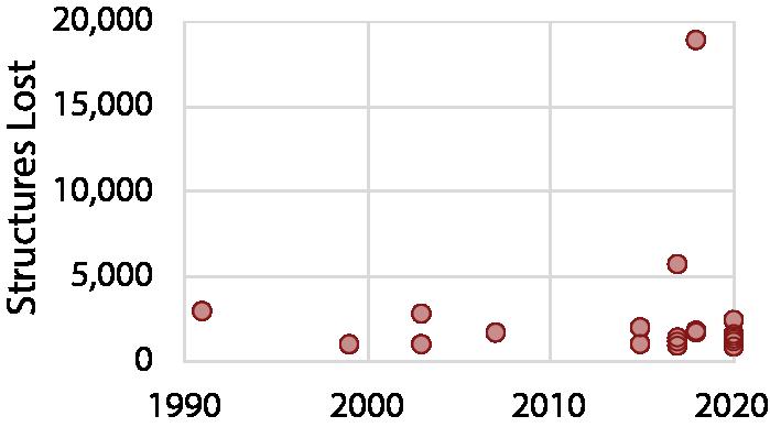
Figure 3: Top 20 Most Destructive Wildfires in California, by structures lost, according to CAL Fire.

Figure 4: Wildfire Role in Positive Feedback Cycle.
wildland vegetation. Once considered an occasional disaster, extreme wildfire is now understood to be an established fixture in the Californian landscape. The increase in frequency and size of these fires has resulted in persistent fire seasons, burning for longer periods with no means of containment. In 2020, wildfires in California claimed the lives of 31 people, over 10,000 structures,
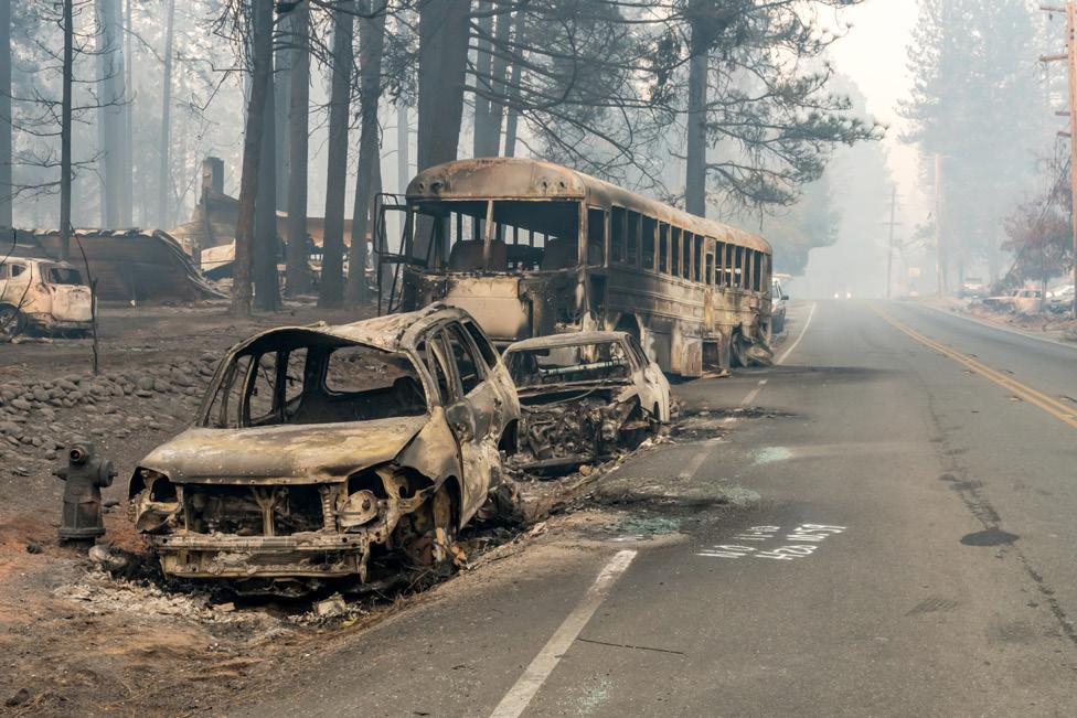
Figure 2: Paradise, CA. 10th, November 2018: Vehicles melted on the side of the road during the Camp Fire. Photograph by Kara Capaldo.
and an estimated 4.2 million acres of land. Five of the fires during 2020 ranked among the six largest in the state’s recorded history.²
The impact of wildfires extends beyond the flame front, as research also predicts increases in premature mortality due to chronic exposure to air pollution.³
This trend of catastrophic wildfires is expected to continue because of climate change and other factors which we will discuss further. Figure 4, illustrates the role of extreme wildfires in a positive feedback cycle, in turn causing more smoke and ever higher temperatures.
1.2 Road Map
In the following sections, this document will look at how California arrived at this position and what designers, homeowners, and stewards can do about it. The source of this information is compiled from an extensive and multidisciplinary review of scholarly journals, media, state resources and federal reports.
2.0 How Did we Get There?
2.1 Historic Fire Regimes
Wildfire is a natural phenomenon that has always been present in California’s landscapes. Wildfires are the unplanned, uncontrolled burning of biomass.
Unimpeded wildfires play an important role in shaping ecology and habitat: opening habitats to sun, encouraging reproduction of certain plant species, and controlling devastating pests.⁴ Periodic fires also serve to prevent the buildup of fuel which can lead to catastrophic fires. California is home to several seasonal fire cycles. These cycles are called fire regimes, and they follow predictable patterns of intensity, frequency, size, and severity. Historically lightning has been the source of non-human ignition, sparking dry vegetation during the hot summer and fall months.
A Berkeley study estimates that before humans, nearly 4.5 million acres of California wildlands burned annually.⁵
2.1.1 Indigenous Peoples’ Use of Fire
Archeologists believe that humans have used fire to impact the California landscape for nearly 11,000 years, since humans first occupied the region.Indigenous people in California understood the ecological impacts of fire. They used deliberate fire (cultural burning) to manage vegetation, wildlife, and food resources. Moreover, Indigenous people also set fires intentionally to burn excess vegetative fuel and prevent catastrophic wildfires These cultures flourished through the supportive relationship of fire as a means of managing resources and landscapes. The Yoruk, Karuk, and Hoopa Tribes of Northern California used fire for several tasks including to encourage the growth of hazel into straight stems, which they used for weaving baskets. With fire, these Tribes promoted the production of foods, like acorns, huckleberries, and even salmon. Additionally, landscapes that were mechanically managed by cultural burning developed greater biodiversity than those reliant on natural ignition patterns.⁶
2.1.2 What Does the System Look Like in Equilibrium?
The health of an ecosystem requires biodiversity, redundancy, and sustained populations. Healthy ecosystems that exhibit these characteristics can continue to support habitats for a large range of organisms. California’s Mediterranean climate features a
Table 1: Characteristics of California's Principal Biomes, assembled from California’s Wildfire and Forest Resilience Action Plan.²


Figure 5: Second Year Growth after Medium-Intensity Fire in a Redwood and Doug Fir Forest. Photograph by Helen Schneider.
wide mix of biomes including conifer forests, grasslands, oak woodlands, chaparral and shrublands. Each region experiences its own microclimate, biodiversity, and fire cycle. 1793 Spanish Governor José Joaquín de Arrillaga issued a proclamation prohibiting cultural burning by Indigenous peoples.⁷ Periods of rapid western immigration increased development and pushed settlers further into fire prone woodlands and shrublands. Early Western conservationists, interested in protecting timber and water resources, created California’s first national forest reservation in 1892. Then in 1910, wildfires burned 3 million acres in Montana, Idaho, and Washington. “The Big Blow-Up”, as it was coined, led to a national policy of fire prevention and suppression.⁷ Policies of suppression continued for another century, offsetting decades of wildfire and resulting in several societal impacts. The seasonal suppression of fire contributed to a widespread impression of fire as foe. It also created a false sense of security for suburban communities residing in fire prone regions without incident.
A UC Berkeley study estimated that between 1950 and 1999, the total amount of land burned in California was only about 5% of what would have burned during a fiftyyear period in prehistoric times.⁵
2.2 Centuries of Suppression
With the arrival of Spanish settlers in California, a practice of fire suppression supplanted Indigenous land management practices. The use of fire by Indigenous peoples threatened European settlers’ ambitions of logging, agriculture, and mining. In 2.2.1 The Growing Scale of Wildfires The frequency, season, scale, and intensity of a burn are crucial variables in how an ecosystem rebounds after a fire. The ecosystems of California have for centuries adapted to consistent wildfire patterns. In recent years

Figure 6: Soberanes Fire, 2016: Forested Landscape after a Stand Replacing Mega-Fire caused by an illegal campfire. Photograph by Kara Capaldo.
there has been a trending rise in wildfire frequency. The severity of these wildfires has also increased causing disruptions in fire behavior and habitat stability. Severe conflagrations can alter the chemical composition of soil, impact nearby water sources, and homogenize the eventual vegetation that returns after the fire subsides.⁸ These “stand replacing fires” are not a new phenomenon in fire prone areas. Some ecosystems like southern California’s chaparral experience them within twenty to sixty years on average. They mark the end of old or diseased flora and the start of a new cohort.⁹ The pattern of fires at this scale in California forests has been historically less frequent than in recent years.⁵ See Figure 5 & 6.
2.3 Components of Fire
Fire is the product of a chemical reaction, combustion, that requires sustained fuel, oxygen, and heat. Figure 7, is referred to as The Fire Triangle, and it serves to illustrate the three ingredients of combustion. If unimpeded, the

Figure 7: The Fire Triangle.
chemical reaction will continue until one of the three either naturally decays or is actively removed. This principle is the foundation of fire suppression. All fire mitigation strategies are preemptive separation of at least one of these three elements from the chemical chain reaction. 2.4 Fire Behavior
Fire behavior is a result of site-specific conditions: nj Fuel: The greater the fuel load, the greater potential for conflagrations. Density, fuel height, and moisture content determine behavior of burn.
nj Weather: Dry, hot summers mixed with strong winds can ignite and spread fire rapidly. The effects of periodic droughts dry out vegetation and create large expanses of kindling.
nj Topography: Fire follows the path of easiest ignition. As fire transitions up slope, it propagates embers and preheats fuels in its path, allowing it to travel faster.⁸
2.4.1 Fuel
Fuel, in the context of wildfire, should be understood as any combustible material. Vegetation and structures are both examples of fuel present in today's fire prone landscapes. Fuel loads are the approximate amount (often characterized by equivalent weight in wood) of fuel present in an area.
Fuel load is determined by the dead moisture content and density of fuels in an area.⁸ Dead fuel moisture content measures water content in vegetation (ranging up to 30% in fire season). Dry fuels with low moisture content increase the chances of combustibility. Fuels with high moisture levels (12-30% depending on fuel type) result in moisture extinction, meaning that fire cannot spread. The higher the moisture content the more heat energy must be transferred for combustion to occur.
2.4.2 Weather
The moisture content of dead fuels fluctuates based on local weather conditions. The temperature and humidity
Table 2: Dead Fuel Moisture Time Lag, adapted from NOAA.
LAG TIME RATE DIAMETER PERIOD OF MEASURMENT
1 hour
Litter Observed weather conditions
10 hour .25” - 1” Observed weather conditions
100 hour 1” – 3” 24 hour average weather conditions
1000 hour 3” – 8” 7 day average weather conditions
change the gradient of moisture exchange between the air and fuel. Large fuels transfer moisture slower than small fuels resulting in delays of moisture equilibrium, see Table 2. Prolonged periods of hot, dry, windy weather cause the lag times of different fuels to reach low moisture contents at the same time, making the area extremely susceptible to wildfire.
2.4.3 Topography
The aspect of a hill changes the solar exposure and moisture content of fuel.10 In the Northern Hemisphere, southwest aspects receive the greatest thermal energy and pose the most vulnerable conditions for wildfire. Narrow northern aspects offer greater self-shading, thereby increasing the retention of fuel moisture in understories. Living fuels are less responsive to swings in moisture content. When trees disappear from the landscape it serves to further imbalance the atmospheric equilibrium.
2.5 Humans and Wildfires
84% of wildfires today are caused by human activity.1 Aging infrastructure (typically overhead power lines), fireworks, sparks from equipment and railroads, debris burning, discarded cigarettes, and arson are all sources of human-caused wildfires. Extremely hazardous air quality and smoke inhalation are a concern for the entire state of California, and its neighbors.³ Plastics, cleaners, leaded paints, fuels,

Figure 8: Ignition of a Powerline: Downed power lines, accounted 1,500 wildfires in the past 6 years. Photograph by Kara Capaldo. Figure 9: September 9, 2020, Smoke and Particulate Matter Occluded the Sun from SF to Yosemite.
and solvents are among the fuel in an urban wildfire. When burned, these toxic substances contribute to unprecedented hazardous air quality that has closed schools hundreds of miles away from the fire source. Doctors are already recommending that people with severe asthma or pulmonary diseases move elsewhere. We have yet to fully understand the impact that these incinerated toxins will have on biological systems.
2.5.1 Emergency Responders
California depends on its emergency responders to protect its communities from wildfire. When responding to a wildfire, emergency personnel have three tiers of priorities:11
1. Life 2.Property
3.Environment Containment of a fire is not always an option, so decisions must be made that favor the safety of people and crew over buildings and land. There are increasing instances when the rate of advancement of a fire poses too great a risk for emergency personnel to respond. Often the defense of a structure is dependent on access, and safe extraction of crew. For this reason, access roads to remote properties with narrow or overgrown road edges are not viable to defend due to risk.
Increasingly, the conditions that emergency personnel are called on to defend against have become more dangerous and overwhelming.

2.5.2 Intangible Costs
The physical and monetary effects of fire are often cited in a fire’s aftermath, however there are intangible consequences to extreme cycles of wildfire. The mental health of firefighters is impacted by relentless fire seasons. Depression and post-traumatic stress disorder (PTSD), among firefighters is higher than in civilian populations.12 Fire service personnel report being severely underfunded and understaffed.
Wildfire survivors may also suffer devastating consequences for years to come. In addition to the trauma of losing a home, some may be forced to relocate, and many will experience PTSD, or other ongoing health consequences. It is estimated that 30-40% of people who are direct victims of a natural disaster will experience PTSD.12 No assessment of development risk can be whole without consideration for the subsequent risk to first responders and residents.
2.6 Development Patterns
The Wildland-Urban Interface (WUI) is defined as a place where humans and human development occur among wildland vegetation, and quantitatively where there is at least one housing unit per forty acres.13 Communities within one-half-mile of wildlands are included among the WUI.
There are two main categories within the WUI where most wildfire structure loss occurs: The Intermix WUI and the Interface WUI.13 nj Intermix WUI describes areas where houses and wildland vegetation are interspersed, where vegetation occupies more than 50% of land area.
nj Interface WUI describes settled communities that abut wildland, where vegetation occupies less than 50% of land area. Suburban developments adjacent to wildland typically fall within this category.
While Intermix WUI has more fire spread by acreage, Interface WUI experiences more structure damage. Over a thirty-year period from 1985-2013, 50% of structures destroyed by wildfire in California were in the Interface WUI, whereas 32% of structures were in the Intermix WUI.14
Increased development in the Wildland Urban Interface and adjacent areas has dramatically increased the fuel loads of already dense, dry conifer forests and overgrown chaparral foothills. Man-made structures prove extremely flammable and structure to structure ignition can be of greater risk than adjacent trees. This was the case with Coffey Park in 2017, and the Town of Paradise, which was leveled by the Camp Fire in 2018.
2.6.1 Who Lives in the WUI?
Among US states, California has the largest number of people living in the Wildland Urban Interface— 11.2 million, or roughly 30% of state residents, as of the 2010 census.13 This number is expected to grow significantly. In a "Business As Usual" growth scenario, 12.9 million acres of sparsely populated and agricultural lands will be added to existing WUI over the next thirty years.15 The current WUI territory is 6.6 million acres of
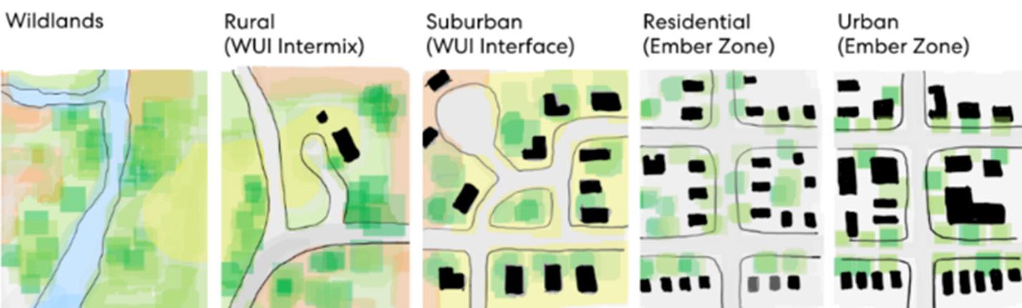
Figure 10: Wildfire Risk in California, Adapted from California Utilities Commission Data.

Figure 11: Developed Land in California and Projected Future Development, Adapted from Fire and Resource Assessment Program FRAP Data.
Figure 12: Wildfire Risk in California, Adapted from California Utilities Commission Data.


Figure 13: Scorched Redwood Tree with New Growth. Photography by Helen Schneider.
California's total 104.7 million acres. This is significant, because despite only occupying 6% of California by size, 82% of buildings destroyed by wildfires are in WUI zones.14
In California, the major populated urban areas are directly adjacent to wildland areas—urban densities separated by mere miles of WUI interface residential development. With catastrophic wildfires appearing to be the new normal in a changing climate, millions of urban residents, even those residing outside the WUI, could also be at risk.
Figure 10, illustrates the development density continuum from wildland to urban areas. In more densely populated areas, embers from a nearby wildland fire may travel over a mile and spark an urban wildfire. 3.1 A New Approach to Land Management
The factors that influence wildfire resilience are complex and include many variables. While climate change is largely responsible, there are several factors that are within human influence: Land Management, Land Development, and Building Practices. The scale of these measures includes the coordination of multiple state and local agencies, Indigenous Tribal communities, and private landowners and homeowners. Several efforts have already been made to begin this coordination. Resources like the Governor’s Office of Planning and Research (ORP) help centralize research and planning efforts to inform local government requirements for privately owned land across the state.2
3.0 What Needs to Change?
To stem the frequency and magnitude of catastrophic wildfires in California, change needs to happen at all scales—from the vast amount of California’s wildland vegetation to that of communities, and down to the details of a home. We must adapt the following approaches:
1. Land Management Practices 2.Land Development Practices 3.Building Practices 3.1.1 Learn from Indigenous Communities
Controlled, low-intensity fire is one of the best means to curb catastrophic wildfires. Recent Indigenous/Western partnerships offer glimmers of hope that California may begin to make amends for decades of suppression. Since 2013, the Yurok Tribe has been actively working to reintroduce cultural burning to their people and to their ancestral lands. To meet stringent legal requirements for prescribed burning (such as having Western equipment on hand), the Yurok Tribe started a knowledge share in 2014—bringing together firefighters from across the country for a training exchange with Indigenous practitioners of prescribed burning. These now biannual exchanges led to national knowledge shares with the nation-wide Indigenous People’s Burning Network.6
These partnerships are crucial and may scale to treat the vast expanses of land that desperately need fire for regeneration, and stem future catastrophic wildfires.
3.1.2 California Resilience Plan To meet these goals, the state committed to treating 500,000 acres of land with fire resilient management by 2025.² They plan to achieve this with a combination of sustainable timber harvest and prescribed fire. The plan supports Indigenous/Western partnerships like those with the Yurok.
In January of 2021, the State of California released California’s Wildfire and Forest Resilience Action Plan. This multiagency report acknowledges the impacts of human activity into wildland areas. The plan seeks to:
nj Increase Wildland Health and Resilience
nj Fortify Community Protection
nj Coordinate Ecological and Economic Forest Management Goals This plan represents a significant step forward and appears to mark a new chapter in the state’s response to wildfire; however, the of amount land that will likely fall victim to catastrophic wildfire by 2025 is much greater than the area California has committed to treat.
The growth of the timber industry continues to loom large in setting land management goals. While the state acknowledges the importance of prescribed burns as a land management tool critical for ecosystem

Figure 14: Factors that Influence Fire Resilience.

Figure 15: Firefighter ignites path of fire for the Bonnie Doon 2020 Prescribed Fire. Figure 16: Firefighters observe managed burn of Bonnie Doon Spring 2020 Prescribed Fire. Photographs by Kara Capaldo.
preservation, prescribed burns account for only one-fifth treated land.16 Accelerating training and permitting for the use of controlled fire is one of the most potentially impactful actions to prevent catastrophic wildfires and restore ecosystems in jeopardy.
3.2 Fuels Reduction
Forest Management is the practice of human intervention to reduce fuel load in a wildland area. There are several different methods used by land stewards:
nj Prescribed Burning nj Grazing nj Wood Chipping
nj Tree Removal (Logging) nj Fuel Breaks Fuel reduction practices essentially replicate a version of what a normal wildfire cycle would produce, aiding in the return of an ecosystem to its natural state.10 National, state, and local agencies may choose to treat their land with some combination of the fuel reduction strategies listed above.
3.2.1 Balancing Fuels Reduction and Habitat
In a prescribed burn, fire occurs low across the understory, burning debris and smaller vegetation without entering the canopy of the tree. The height of vegetation affects flame heights.11 When an understory becomes overgrown, the flames can ladder up to the canopy above destroying legacy habitats. This type of vegetation is called “ladder fuels.”10 It is important to remove lower limbs on legacy trees and cut back shrubs to avoid the fire from leaving the ground.

Fuel reduction projects end up with piles, and often they are intended to be removed or chipped. However, these piles can provide significant habitats.10
Land stewards may remove a habitat pile, away from nearby trees to prevent it from becoming a hotspot. Locating dead wood piles in a gap of vegetation may allow it to serve significant habitat benefits. Dead wood features also contribute to the overall health of the forest returning nutrients and protection for a bevy of species.10
3.3 A New Approach to Development
To mitigate against catastrophic loss of human life and property, California must adapt development practices that consider wildfire risk and collective dependency.
3.3.1 Guidelines for Development
It is recommended that suburban and residential communities that reside adjacent to wildlands should be separated by 300-foot-wide defensive belts to help buffer structures from potential wildfires. The 300foot belt may be a highway, or other zone kept clear of combustible material.11 This belt breaks the continuity of
fuel leading to more densely populated areas and serves to protect against the flame front; however, with embers known to spark fire after floating airborne for over a mile, ember ignition remains a risk.17 This scale of intervention is not always achievable nor is necessarily appropriate to replicate for all communities. If habitat protection and buffering cannot coexist then the communities should consider more selective prescribed burns, utilizing manmade roads, bodies of water and natural barriers. Neglecting to invest in fuel treatment all together will leave communities vulnerable to wildfire and pose serious hazards to responding fire personnel. It seems likely that, the mounting maintenance of wildfire mitigation will gradually warrant managed retreat, the relocation of structures from an area of risk, in some WUI Interface and Intermix areas. It should be noted that this last strategy has historically been unpopular with property owners and real-estate interest. Globally the impacts of climaterelated migration will displace millions, recontextualizing expectations and the options left for holdouts in the coming years.

Figure 17: Summary of SPUR Principles for Managing Wildfire Risk and New Development.18 Figure 18: Road acting as a fuel break during prescribed burn, Bonnie Doon Spring 2020, Photograph by Kara Capaldo.
SPUR (San Francisco Urban Research Association), a nonprofit think tank focused on regional planning and public policy in the Bay Area, in collaboration with California YIMBY and Greenbelt Alliance, recently set forth a set of development guidelines for wildfire resilience. The initiative is summarized in Figure 17.18
3.4 A New Approach to Building
As architects designing buildings in the WUI and other fire prone areas, we have a significant influence and responsibility in creating sustainable, fire-resistant communities.
Given the global rising temperatures, increased droughts, and historic fire suppression, residents, and landowners within the WUI and adjacent fire prone areas will continue to be at risk from wildfire transmission. Private property owners have a vital responsibility to maintain the land they settle, not only in service of the natural habitat, but also to protect their own safety and economic investments.
While a wildfire cannot always be prevented, there are many measures that individual property owners can take to reduce the likelihood of ecosystem and structure loss in the event of a fire. These fall into three primary categories: 1. On-site Land Management, (addressed in previous section.)
2.Defensible Space
3.Home hardening.

3.4.1 Defensible Space
Defensible space is a means of fuel reduction that seeks to reduce and spread-out fuel sources around the structure. Defensible space deals with the immediate area around a structure called the Home Ignition Zone (HIZ) and is thereby distinct from sitewide fuel management beyond this 100-200 foot area. There are three conceptual zones of increasing distance in the HIZ drawn around the perimeter of the structure.19 See Table 3. Each zone is intended to cut off the easy transmission of dense contiguous fuels to the next. During a fire, spacing may not only limit structure ignition from nearby vegetation but also the chances of structure-to-structure ignition. For this reason, it is important to coordinate defensible space with neighboring structures within the areas defined. 1. Immediate or Ignition Zone (0 to 5 feet) 2.Intermediate Zone (5 to 30 feet)
3. Extended or Reduced Fuel Zone (30 to 100+ feet) Creating defensible space is not a onetime investment but a continued strategy of managing land around structures. Much like the upkeep of a building, the site also requires periodic servicing to keep it healthy and functioning. Overlooking this upkeep can greatly increase the risk of fire. Special vigilance should be taken during fire seasons. Many communities recognize the shared benefits of establishing fire protection measures across large areas of land. It is important to check for local community guidelines or action plans as a starting point for creating a defensible space plan.
Table 3, outlines the guidelines for how to mitigate fire risk in each of the three zones.
3.4.2 Home Hardening
It is recommended that homeowners prioritize the home and its immediate area and work outward
Table 3: Defensible Space Checklist compiled from NFPA Checklist.20 Note: some jurisdictions may have additional requirements.

Figure 19: Defensible Space, Zones of protection extend at slopes to respond to fire behavior. Adapted from Fire Safe Council19 and others.

Figure 20: Tree & Shrub Clearances, grade and vegetation heights determine clear spacing recommended to avoid ladder fuels. Designers should seek consultant input on site specific conditions. Adapted from NFPA diagram.20
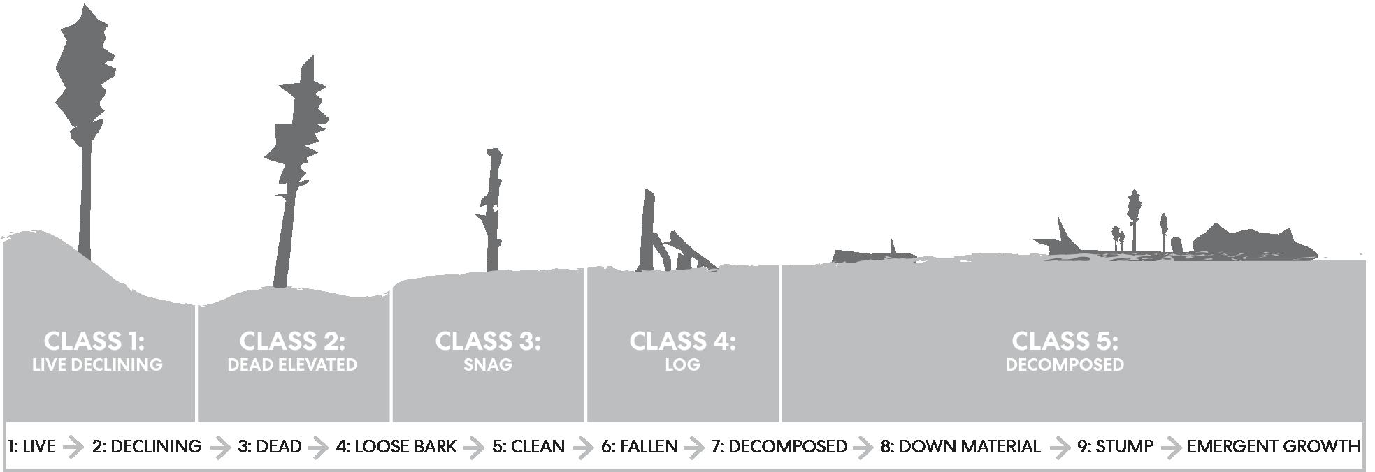
Figure 21: Tree Decay Classes and Life Cycle, Dead or dying trees can be sources of fuel within defensible zones. They are also vital habitat resources. All defensible space plans must balance the benefits and risks of removing or preserving dead wood form site. Adapted from The Columbus Dispatch and Maser.

from the center, moving on to the zones of Defensible Space, discussed previously.19 This approach prioritizes the most vulnerable and impactful areas first and can be developed in stages. In several states including California many of these home hardening measures have now been integrated in state code requirements.
The Home Hardening Table, Table 4, outlines the steps one can take to improve the chances that a home or structure will resist ignition in the event of a wildfire.
Table 4: Home Hardening Checklist, compiled from Wildfire Home Retrofit Guide,21 NFPA.20 Headwater Economics22; and the 2019 CBC.
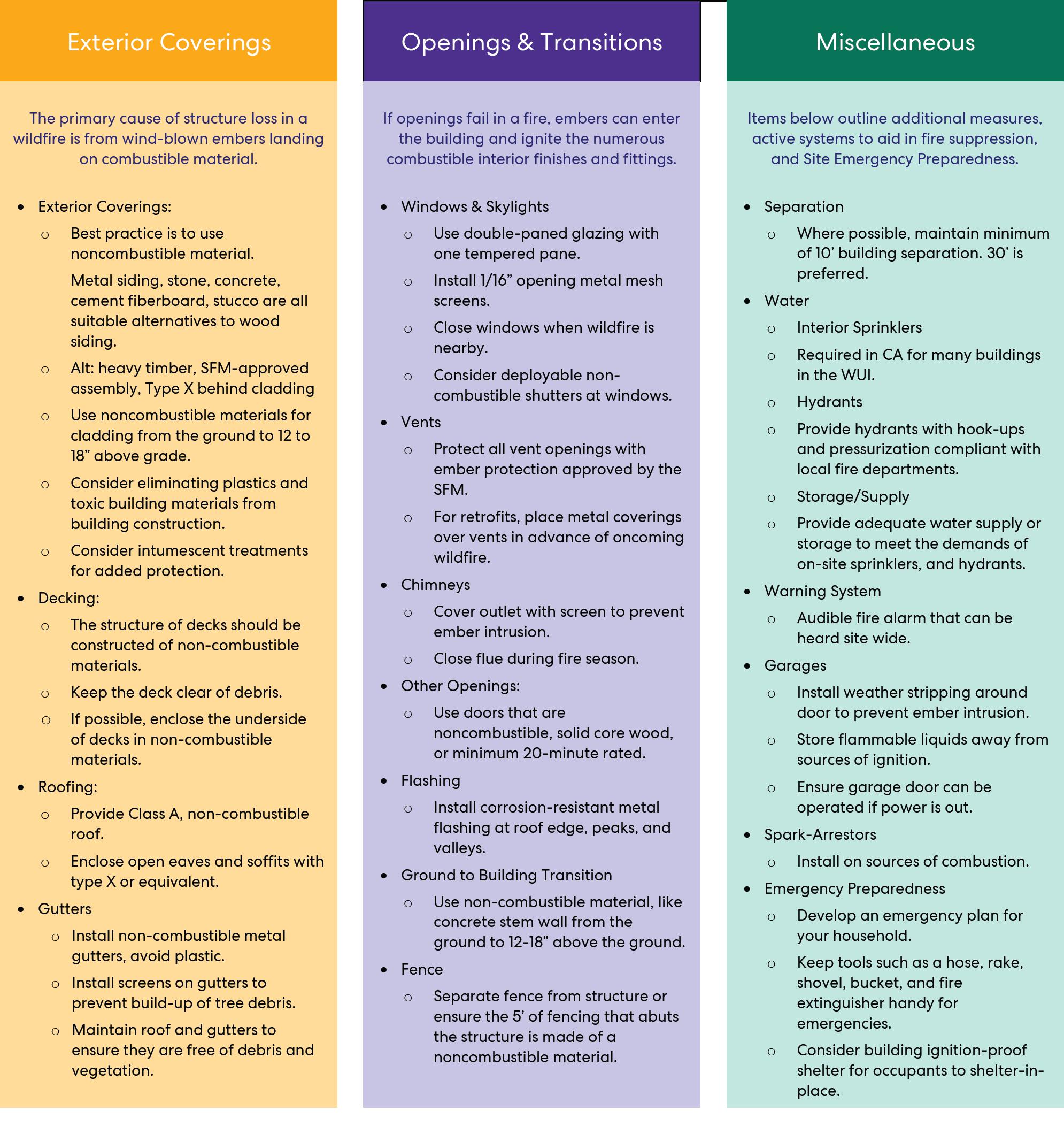

Figure 22: Points of Common Ignition.
3.4.3 Emerging Technologies
There are several emerging technologies that designers and homeowners may consider when developing a home hardening strategy. Often these systems are omitted in early design phases due to cost or maintenance concerns. However, as the requirements for building in fire prone areas increases, the prevalence of such systems may become more common.
Depending on their positioning, exterior sprinklers may help to suppress ignition on and around a structure.23 Any active systems that are reliant on electricity for pumping may face issues during a fire event if electricity is lost. Available water is also an important consideration.

Figure 23: Richburg, S.C. - This ember storm simulation by the IIBH Research Center highlights common pathways of ignition. Photograph by The Insurance Institute for Business & Home Safety.23
Fire retardant membranes are a developing industry. These come in a variety of systems and may help resist surface ignition. Due to the wide range of products on the market it is difficult to ascribe effectiveness. Fire retardant gels can be sprayed on in advance of an oncoming fire.23 These have a short window of effectiveness after application and are thereby not practical for most situations. Some gels may damage paint finishes. It is also prudent to verify the ecological impacts of any chemical introduced to the site. Manufacturers may use phrases like “environmentally friendly”, or “green” to intimate that their product is safe for the environment, but they are not an indication of specific qualifications.
Table 5: Site Access Checklist for Designing for Fire Department Access adapted from NFPA guidelines for Fire Apparatus Access Roads.


Figure 24: Camp Fire 2018, flames moving up hill. Photograph by Kara Capaldo. Figure 25: Fox Theater in Oakland, CA. Midday on September 9, 2020, the particulate matter from wildfire smoke obscured the sun and turned skies red across the state. Photo by DeVaun Salters.
4.0 Conclusion
There is no one-size-fits-all solution to establishing fire resilient environments. The exact strategies put in place must respond to a project’s site-specific conditions. There is also no one party who is an expert in all aspects of wildfire response. Proper wildfire design is collaborative and multidisciplinary.
As designers committed to sustainable and regenerative design, we need to be attuned to the complex systems and landscapes in which our projects reside. While we have outlined steps to decrease wildfire risk to humans, no combination of these methods outlined will ensure complete protection. It would be misguided if one were to use the measures of fire defense without acknowledging the inherent risk of building in these areas. Continuing to develop in wildland areas renews our societal commitment to the dichotomous preservation of human settlements in landscapes that are defined by, and rely on, wildfires for their existence.

4.1 Further Study
We see this work as the beginning of an ongoing conversation about creating fire resilient landscapes and communities. Over the course of our research, our team identified a few areas where further study may be beneficial to our studio and our profession: 1. Expert Symposium: A series of interdisciplinary open-form discussions with experts on topics of wildfire resilience.
2.A New Vernacular: A multidisciplinary design exercise to develop a new fire-resilient typology for regenerative Californian construction.
3.Fire Insurance: Exploring the influence of fire insurance on development and the building industry.
4.Silviculture: Exploring the synergy between fuel reduction efforts and sustainable mass timber industries.
Acknowledgments
Special thanks to Hector R. Estrada (Deputy Chief of Fire Prevention, Sant Clara County Fire Department).
Additional thanks to Kara Capaldo for providing much of the photography featured in this report.
References
[1] Insurance Information Institute. (2021) Facts + Statistics: Wildfires, Retrieved on (2021, January 20) from iii.org: https://www.iii.org/fact-statistic/ facts-statistics-wildfires [2] State of California, (2021). California's Wildfire and Forest Resilience Action Plan: A Comprehensive Strategy of the Governor's Forest Management Task Force, Retrieved on (2021, April 12) from https://www.fire.ca.gov/media/ps4p2vck/ californiawildfireandforestresilienceactionplan.pdf [3] O’Dell, K., Bilsback, K., Ford, B., Martenies, S. E., Magzamen, S., Fischer, E. V., & Pierce, J. R. (2021). Estimated mortality and morbidity attributable to smoke plumes in the United States: Not just a western US problem. GeoHealth, 5, e2021GH000457. Retrieved on (2021, August 13) https://doi. org/10.10292021GH000457Special Section:Fire in the Earth SystemRESEARCH ARTICLE 1 of 17 [4] Pausas, J. G., & Keeley, J. E. (2019). "Wildfires as an Ecosystem Service". Frontires in Ecology and the Enviornment, Vol. 17, No. 5, pp. 289-295. [5] Stephens, S. L., Martin, R. E., & Clinton, N. E. (2007). 'Prehistoric Fire Area and Emissions from California's Forests, Woodlands, Shrublands, and Grasslands'. Forest Ecology and Management, 205-216. Retrieved on (April, 4 2021) from https://nature.berkeley.edu/stephenslab/ wp-content/uploads/2015/04/Stephens-et-al.-CA-firearea-FEM-2007.pdf [6] Buono, P. (2020). “Quiet Fire: Indigenous tribes in California and other parts of the U.S. have been rekindling the ancient art of controlled burning” , The Nature Conservancy, Winter 2020. Retrieved on (January 20, 2021) from https://www. nature.org/en-us/magazine/magazine-articles/ indigenous-controlled-burns-california/ [7] Forest History Society, (2020) U.S. Forest Service Fire Suppression. Retrieved on (April 4, 2021) from https:// foresthistory.org/research-explore/us-forest-servicehistory/policy-and-law/fire-u-s-forest-service/u-sforest-service-fire-suppression/ [8] Schroeder M., & Buck. C. (1970). Fire Weather: A guide for applicaiton of meteorological informationto forest fire control operations, U.S. Department of Agriculture: Forest Service, Agriculture Handbook 360. [9] Van Pelt. R. (2008). Identifying Old Trees and Forests in Eastern Washington. Washington. Washington State Department of Natural Resources, Olympia, WA pp. 29-68.
[10] Strong N., Bevis K., & Bracher G. (2016). WildlifeFriendly Fuels Reduction in Dry Forests of the Pacific Northwest. Woodland Fish & Wildlife Group, Portland, OR.
[11] Nicholls, B. (2018). Defensible Space– Controlling Ignition Potential in the Home Ignition Zone. Living With Fire In California's Coast Ranges. California Fire Science Consortium, Rohnert Park, CA.
[12] Stern, J. (2020). “A Mental-Health Crisis Is Burning Across the American West”. The Atlantic, July. [13] Radeloff V. C., Helmers D., Kramer H. A., Mockrin M. H., Alexandre P. M., Bar-Massada A., Vutsic V., Hawbaker T. J., Martinuzzi S., Syphard A. D., & Stewart S. I. (2018). Rapid Growth of The US Wildland-Urban Interface Raises Wildfire Risk. PNAS Proceedings of the National Academy of Sciences of the United States of America, Vol. 115, No. 13, pp. 3314-3319.
[14] Kramer H. A., Mockrin M. H., Alexandre, P. M., & Radeloff, V. C. (2019). 'High wildfire damage in interface communities in California'. International Journal of Wildland Fire 2019, Vol. 28, pp. 641-650.
[15] Mann M. L., Berck P., Moritz, M. A., Batllori E., Baldwin J. G., Gately C. K., & Cameron R. D. (2014). 'Modeling Residential Development in California from 2000 to 2050: Integrating Wildfire Risk, Wildland and Agricultural Encroachment'. Land Use Policy, Vol. 41, pp. 438-452.
[16] Schoennagel T., Balch J. K., Brenkert-Smith H., Dennison P. E., Harvey B. J., Krawchuk M. A., Mietkiewicz N., Morgan P., Moritz M. A., Rasker R., Turner M. G., & Whitlock, C. (2017). "Adapt to more Wildfire in Western North American Forests as Climate Changes". PNAS Proceedings of the National Academy of Sciences of the United States of America, Vol. 114, No. 18, pp. 4582-4590.
[17] Gollner M. R., Hakes R., Caton S., Kohler K. (2015). Pathways for Buildign Fire Spread at the Wildland Urban Interface (WUI) Liturature Review and Gap Analysis. The Fire Protection Research Foundation. Retreived on (October 10, 2020) from: https://www. nfpa.org/-/media/Files/News-and-Research/Firestatistics-and-reports/Emergency-responders/ RFPathwaysForBuildingFireSpreadWUI.ashx [18] Brown-Stevens A., Hanlon B., & Karlinsky S. (2021). Managing Wildfire Risk and New Development. Retrieved on (April 20, 2021) from SPUR News: https://www.spur.org/news/2021-04-16/ managing-wildfire-risk-and-new-development [19] Fire Safe Council. (2019). Creating Defensible Space. Retrieved on (April 4, 2021) from Santa Clara Country Fire Safe Council: https://sccfiresafe.org/prepare/ creating-defensible-space/ [20] National Fire Protection Association NFPA, (2021). Preparing homes for wildfire. Retreived on (April 4, 2021) from NFPA.org: https://www.nfpa.org/ Public-Education/Fire-causes-and-risks/Wildfire/ Preparing-homes-for-wildfire [21] Kocher S. D., & Murphy C., (2020) Wildfire Home Retrofit Guide: How To Harden Homes Against Wildfire. Retreived on (January 20, 2021) from: https://www. researchgate.net/publication/348756292
[22] Quarles S. L., & Pohl K. (2018). Building a WildfireResistant Home: Codes and Costs. Headwaters Economics, Retrieved on (January 10, 2021) from https://headwaterseconomics.org/wildfire/homes-risk/ building-costs-codes/
[23] Insurance Institute for Business & Home Saftey IBHS. (2021). Regional Wildfire Retrofit Guides. Retrieved from disastersaftey.org: https://disastersafety.org/wildfire/ regional-wildfire-retrofit-guides/

