Final Port Stephens Council Coastal Management Plan sml
2024 Coastal Management Program Port Stephens
This document provides strategic direction and actions to address threats to the coast and maintain the ecological, social and economic values Port Stephens’ coastal zone.
Contact Information
Rhelm Pty Ltd
ABN : 55 616 964 517
50 Yeo Street
Neutral Bay NSW 2089 Australia
Lead Author: Tanja Mackenzie tanja.mackenzie@rhelm.com.au
Document Control
00
Prepared For: Port Stephens Council
Project Name: Port Stephens Coastal Management Program
Cover photo: Stockton Beach viewed from Birubi Point (T. Mackenzie)
Rhelm Pty Ltd has prepared this report for its client and it is not to be used by a third party without written permission from Rhelm. The report has been prepared and reviewed by suitably qualified persons. The scope of the report is based on specific instructions and Rhelm’s proposal. Rhelm is not liable for any inaccuracies in or omissions to information that is provided by the client and sourced from other third parties.
The findings and any estimates which have been provided are presented as estimates only and are based on a range of variables and assumptions. The report was prepared on the dates shown and is based on the conditions encountered and information received at the time of preparation. Rhelm disclaims responsibility for any changes that may have occurred after this time.
In this report, Rhelm does not purport to give or provide financial advice, financial modelling or forecasting. Nor does it give legal advice. Appropriate specialist advice should be obtained where required.
Rhelm does not authorise the use of this report by any third party, unless Rhelm has consented to that party’s reliance in writing. Third parties should make their own inquiries and seek advice in relation to their particular requirements and proposed use of the report subject matter. To the extent permitted by law, Rhelm expressly disclaims and excludes any liability for any loss, damage, cost or expenses suffered by any third party relating to or resulting from the use of, or reliance on, any information contained in this report.
The report remains the intellectual property of Rhelm unless otherwise agreed in writing.
Tanja Mackenzie, Michael Rosenthal Emma Maratea
Acknowledgements
Acknowledgement of Traditional Owners
We acknowledge the Worimi as the original Custodians and inhabitants of Port Stephens.
May we walk the road to tomorrow with mutual respect and admiration as we care for the beautiful land and waterways together.
Acknowledgement of Financial Assistance
Port Stephens Council has prepared this document with financial assistance from the NSW Government through its Coastal and Estuary Grants Program. This document does not necessarily represent the opinions of the NSW Government or the NSW Department of Climate Change, Energy, the Environment and Water (NSW DCCEEW).
Photo: Tomaree Mountain, viewed from Shoal Bay (T. Mackenzie, 2023)
Glossary and Abbreviations 1
Abbreviation / Term Description
Adaptation
Adjustment in natural or human systems in response to actual or expected climate change or its effect, to moderate harm or to take advantage of beneficial opportunities.
Aeolian sand transport The erosion, transport and deposition of sand by the action of wind. Also referred to in this CMP as a wind-blown sand.
ASS Acid Sulfate Soils
Average Recurrence Interval (ARI)
Beach erosion
Beach nourishment
The Average Recurrence Interval (ARI) refers to the long-term average number of years between the occurrence of an event (e.g. a coastal storm) as big as (or larger than) the selected event. ARI is another way of expressing the likelihood of occurrence of a storm event Also known as Return Period.
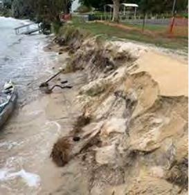
Refers to landward movement of the shoreline and/or a reduction in beach volume, usually associated with storm events or a series of events, which occurs within the beach fluctuation zone. Beach erosion occurs due to one or more process drivers; wind, waves, tides, currents, ocean water level, and downslope movement of material due to gravity.
Beach restoration or augmentation using clean dredged or fill sand. Dredged sand is usually hydraulically pumped and placed directly onto an eroded beach or placed in the littoral transport system. When the sand is dredged in combination with constructing, improving, or maintaining a navigation project, beach nourishment is a form of beneficial use of dredged material.
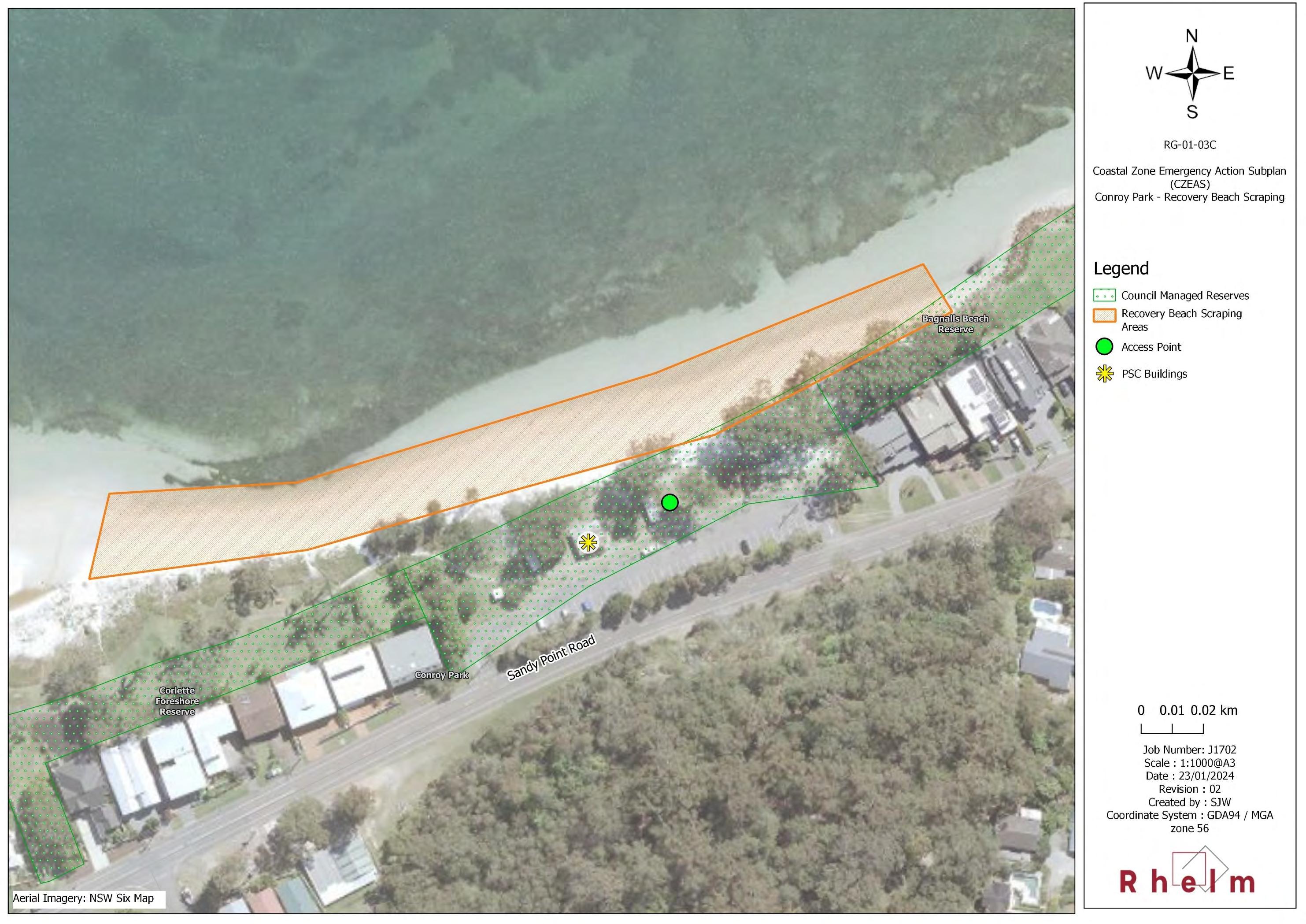
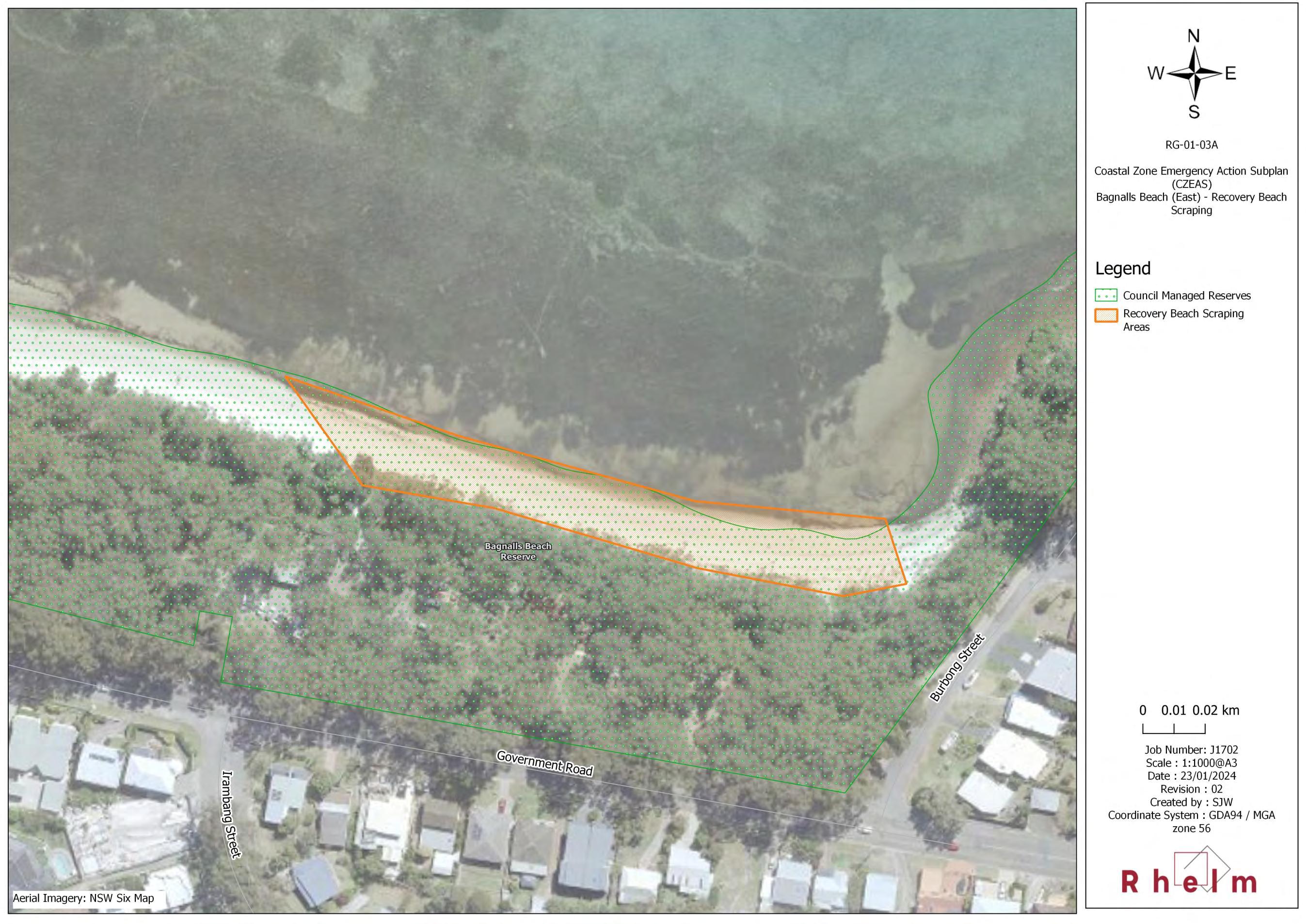
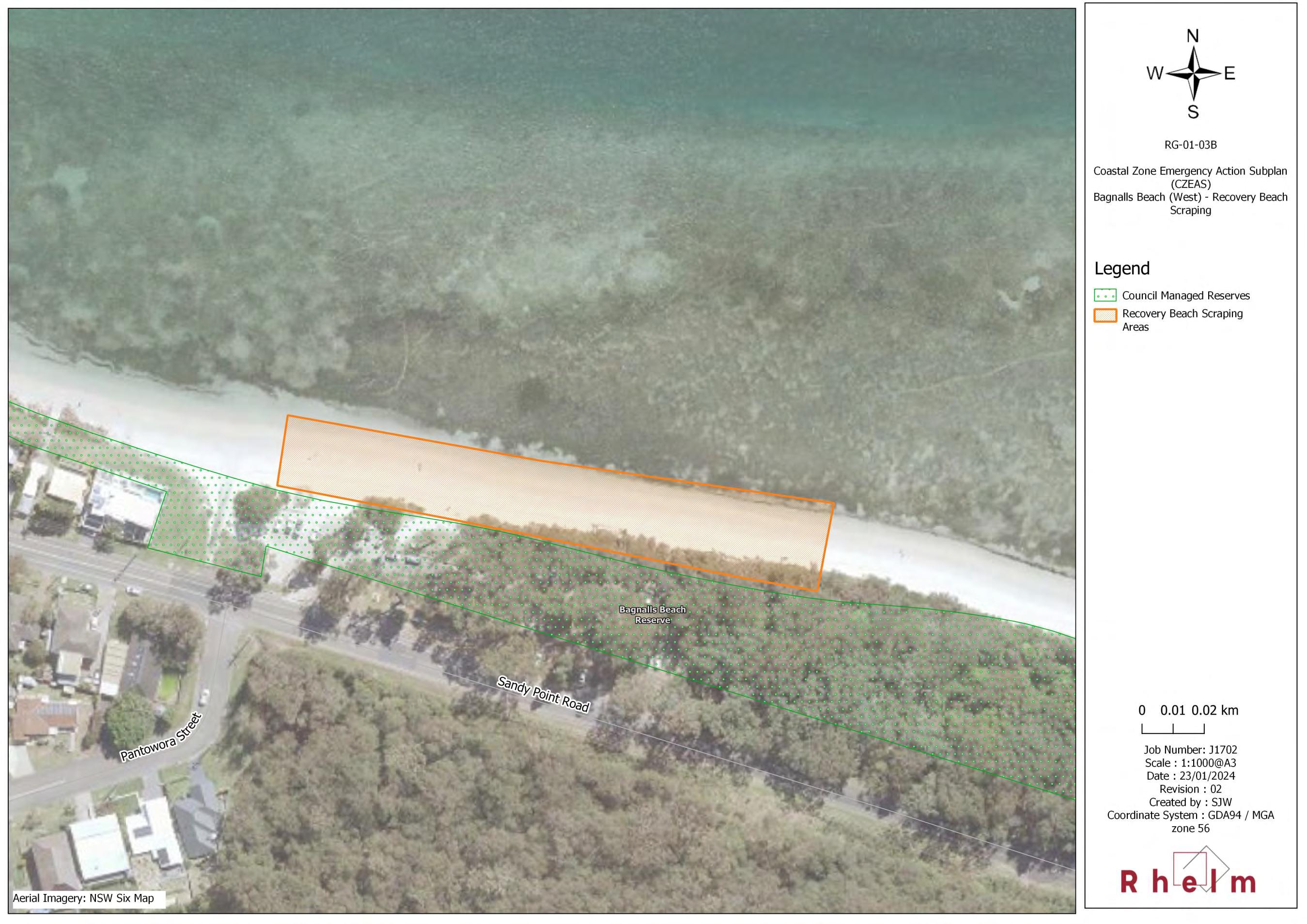
Beach scraping Also referred to as ‘nature assisted beach enhancement’ is a mechanical intervention to speed up the natural processes of berm and foredune recovery after a storm event.
CBA
CEA
Cost-benefit Analysis
Coastal Environment Area
CM Act NSW Coastal Management Act 2016
CM Manual The NSW Coastal Management Manual (OEH, 2018b).
Coastal dune
Coastal dune field
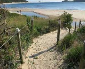
Vegetated and unvegetated sand ridges built-up at the back of a beach. They comprise dry beach sand that has been blown landward and trapped by plants or other obstructions. Stable sand dunes act as a buffer against wave damage during storms, protecting the land behind from saltwater intrusion, sea spray and strong winds. Coastal dunes also act as a reservoir of sand to replenish and maintain the beach at times of erosion.
Defined under Schedule 1 of the Environmental Planning and Assessment Regulation 2021 as ‘a system of wind-blown sand deposits extending landwards of the coastline, whether active or stable’. The Stockton Bight is a coastal dune field.
In this CMP, the term 'coastal erosion' is used to refer to erosion that meets the following definitions under clauses 4(a) and 4(g) the CM Act (see row below):
• ‘beach erosion’. This term is typically applied to open coastlines
Coastal erosion
Coastal hazard
• 'erosion...of foreshores caused by tidal waters and the action of waves, including the interaction of those waters with catchment floodwaters'. This term is relevant to estuarine foreshores (i.e. Port Stephens).
Defined under clause 4 of the CM Act to mean the following:
• beach erosion
• shoreline recession
• coastal lake or watercourse entrance instability
1 Where possible, definitions for terms have been sourced from the Coastal Management Glossary (OEH, 2018a).
Abbreviation / Term Description
• coastal inundation
• coastal cliff or slope instability
• tidal inundation
• erosion and inundation of foreshores caused by tidal waters and the action of waves, including the interaction of those waters with catchment floodwaters.
Coastal inundation
Coastal Management Area (or CMA)
Coastal Management Program (CMP)
Coastal processes
Coastal protection works
Coastal threat
Flooding of low-lying areas by ocean waters, caused by a higher than normal sea level (e.g., due to storm tide).
Any one of four areas that make up the coastal zone as defined in the CM Act. These are the coastal wetlands and littoral rainforests area, coastal vulnerability area, coastal environment area, and the coastal use area.
A long-term strategy for the coordinated management of land within the coastal zone, prepared and adopted under Part 3 of the CM Act.
Coastal processes are the set of mechanisms that operate at the land-water interface. These processes incorporate sediment transport and are governed by factors such as tide, wave and wind energy.
The CM Act defines coastal protection works as:
a) beach nourishment
b) activities or works to reduce the impact of coastal hazards on land adjacent to tidal waters, including (but not limited to) seawalls, revetments and groynes.
A process or activity that is putting pressure on or impacting on the health or function of a coastal ecosystem, or on the amenity and social or cultural value of the coastal landscape.
CN City of Newcastle
CUA
Coastal Use Area
CVA Coastal Vulnerability Area
CWLRA Coastal Wetlands and Littoral Rainforest Area
CZEAS Coastal Zone Emergency Action Strategy
NSW DCCEEW
NSW Department of Climate Change, Energy, the Environment and Water
DCP Development Control Plan
DPE Former NSW Department of Planning and Environment; now split into two departments, DPHI and NSW DCCEEW.
DPHI
DPI
Dune transgression (or major sand drift)
EP&A Act
NSW Department of Planning, Housing and Infrastructure
NSW Department of Primary Industries
Sand drift describes the movement of sand by wind. On the coast, this generally describes sand movement resulting from natural or human-induced degradation of dune vegetation, resulting in either nuisance or major sand drift. Dune transgression is classified as major sand drift.
NSW Environmental Planning and Assessment Act 1979
ESD Ecologically Sustainable Development
FM Act
NSW Fisheries Management Act 1994
Foredune The larger and more mature dune lying between the incipient dune and the hind-dune area. Foredune vegetation is characterised by grasses and shrubs. Foredunes provide an essential
Abbreviation / Term Description
reserve of sand to meet the erosion demand during storm conditions. During storm events, the foredune can be eroded back to produce a pronounced dune scarp.
Foreshore
Highest astronomical tide (HAT)
The part of the shore, lying between the crest of the seaward berm (or upper limit of wave wash at high tide) and the ordinary low water mark, that is ordinarily traversed by the uprush and backrush of the waves as the tides rise and fall; or the beach face, the portion of the shore extending from the low water line up to the limit of wave uprush at high tide. The CM Act defines the foreshore as ‘the area of land between highest astronomical tide and the lowest astronomical tide’.
The highest level which can be predicted to occur under average meteorological conditions and any combination of astronomical conditions.
HWC Hunter Water Corporation
LALC Local Aboriginal Land Council
LEP Local Environmental Plan
LGA Local Government Area
LG Act
NSW Local Government Act 1993
LLS Local Land Services
Longshore transport (littoral drift)
Marine sand inundation
Refers to the sediment moved along a coastline under the action of wave-induced longshore currents.
This term is described in the Scoping Study (PSC, 2020) as the movement of marine sand by waves and weather conditions such that it accumulates in certain locations where it may then become an issue, such as with respect to navigation. It is understood the term relates to benthic sediment transport and accretion, and is referred to in this CMP as accretion of marine sand.
MCC MidCoast Council
Mean High Water Mark (MHWM)
The line of the medium high tide between the highest tide each lunar month (the springs) and the lowest tide each lunar month (the neap) averaged out over the year.
MHL Manly Hydraulics Lab
MIDO Maritime Infrastructure Delivery Organisation (within Transport for NSW)
Multi-criteria analysis (MCA)
A logical and structured decision-making tool for complex problems involving multiple factors or criteria, where a consensus is difficult to achieve. It may involve processes such as ranking, rating (with relative or ordinal scales) or pairwise comparisons. The process allows participants to consider, discuss and evaluate complex trade-offs among alternatives
NP&W Act NSW National Parks and Wildlife Act 1974
No or low regrets actions
Actions which would be justified under any plausible future scenario (i.e., they are best practice in any circumstance), and similarly, actions which require only moderate investment to achieve a beneficial outcome.
NPWS National Parks and Wildlife Service
NSW New South Wales
NSW IP&R Framework The NSW Integrated Planning and Reporting Framework
NSW SES NSW State Emergency Service
PoM Plan of Management
Abbreviation / Term Description
Probabilistic hazard assessment
A risk-based approach to managing coastal hazards that takes uncertainty into account by considering both the likelihood and consequence of hazard occurrence. It applies a stochastic simulation to evaluate coastal processes. The technique uses a distribution of values for each parameter to account for expected variation, or uncertainty, rather than single values. Parameters are then combined using a Monte-Carlo technique to produce a probabilistic forecast of future shoreline position.
PSC Port Stephens Council
PSLEP 2013 Port Stephens Local Environmental Plan 2013
Resilience
Resilience and Hazards SEPP
Revetment or seawall
The ability of a system (human or natural) to adapt to changing conditions (including hazards or threats, variability and extremes), and rapidly recover from disruption due to emergencies. Resilient systems or communities have the capacity to ‘bounce back’ after a disrupting event such as a major storm or an extended heat wave, to moderate potential damages, take advantage of opportunities, maintain or restore function or to cope with the consequences.
State Environmental Planning Policy (Resilience and Hazards) 2021
A type of coastal protection works which protects assets from coastal erosion by armouring the shore with erosion–resistant material. Large rocks/boulders, concrete or other hard materials are used, depending on the specific design requirements.
Riparian Pertaining to the banks of a body of water, such as an estuary.
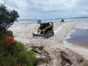
Sand carting
Sand carting is the transfer of sand from one location on a beach to another, typically using trucks.
SEPP State Environmental Planning Policy
Shoreline recession
Refers to continuing landward movement of the shoreline, that is, a net landward movement of the shoreline, generally assessed over a period of several years. As shoreline recession occurs the beach fluctuation zone is translated landward.
SLSC Surf Life Saving Club
TfNSW Transport for NSW
Threats
Threshold
In the coastal management context, a threat is a process or activity which puts pressure on one or more coastal assets or values. Threats may include land uses (e.g., urban, recreation), land management, climate change, industrial discharges, stormwater runoff, overfishing, invasive species as well as the pressures from coastal hazards.
Can be identified for aspects of coastal systems, to highlight tipping points for irreversible change.
An ecological threshold is the point at which there is an abrupt change in the structure, quality, or functioning of an ecosystem or where external changes produce large and persistent responses in an ecosystem. A species threshold may disrupt aspects of the species population, productivity, reproduction, or habitat in response to a stressor. Such ‘tipping points’ can lead to unwanted changes in ecosystems and may slow the recovery of ecosystems or limit their ability to achieve more resilient states following a disturbance.
Similarly, a social or economic threshold of change in a coastal community indicates the point at which the structure, function, social connectedness, equality or economic activity of the community changes beyond recovery.
Thresholds can also be defined for coastal water levels as they relate to the resilience of certain types of development.
Abbreviation / Term Description
Tidal inundation
Trigger
Wave run-up
Wave set -up
The inundation of land by tidal action under average meteorological conditions and the incursion of sea water onto low lying land that is not normally inundated, during a high sea level event such as a king tide or due to longer-term sea level rise.
Pre-negotiated decision-making points and commitments, so that action on coastal risks is taken when necessary, and when it is most convenient and affordable for the affected community
The vertical distance above mean water level reached by the uprush of water from waves across a beach or up a structure.
The rise in the water level above the still water level when a wave reaches the coast. It can be very important during storm events as it results in further increases in water level above the tide and surge levels.
WCLB Worimi Conservation Lands Board
Executive Summary
Stephens Coastal Management Program
Port Stephens Council (hereafter ‘Council’ or PSC) has with the assistance of the NSW Department of Climate Change, Energy, the Environment and Water (NSW DCCEEW) prepared a Coastal Management Program (CMP) to provide strategic direction and specific actions to address threats to the coast and maintain the ecological, social and economic values of the Port Stephens coastal zone.
The CMP is a plan of action for Council, public authorities and land managers responsible for management of the Port Stephens coastal zone to:
• Address coastal hazard risks;
• Preserve habitats and cultural uses and values;
• Encourage sustainable agricultural, economic and built development in the coastal zone;
• Maintain or improve recreational amenity and resilience; and
• Adapt to emerging issues such as population growth and climate change.
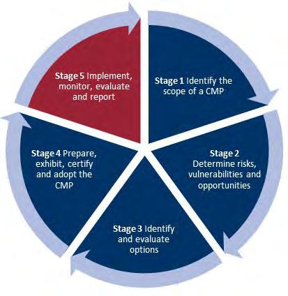
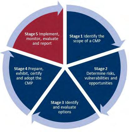
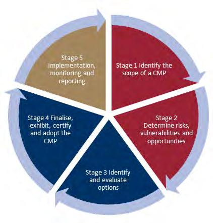
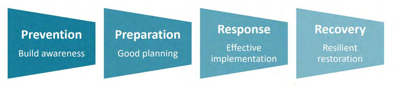
The NSW Coastal Management Manual (OEH, 2018b) specifies five stages in preparing a CMP (Figure E-1).
Figure E-1 Stages in preparing and implementing a CMP (after: OEH, 2018b)
Port
The CMP Study Area
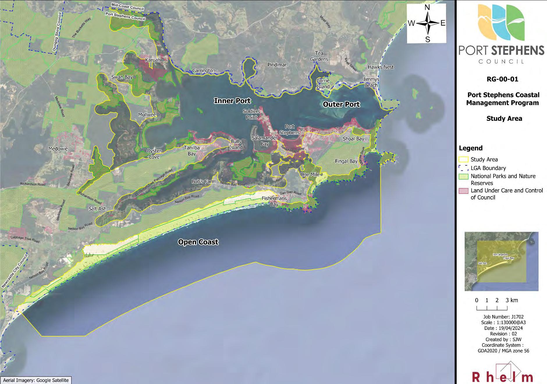
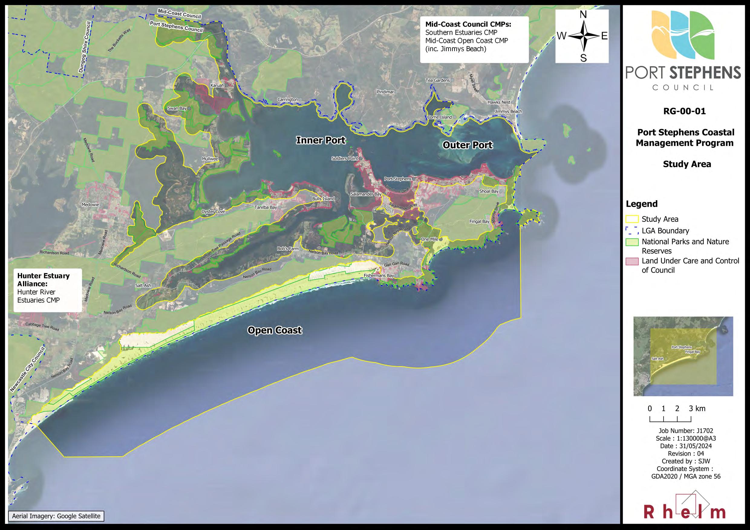
The study area comprises the coastal zone of the Port Stephens Local Government Area (LGA), encompassing the Open Coast, Outer Port and Inner Port areas. As discussed in the Scoping Study (PSC, 2020), each of these three regions within the broader study area (the Open Coast, Inner Port and Outer Port) differ with respect to their exposure and vulnerability to different types of coastal hazards and their environmental and social values and uses. A map of the study area is provided in Figure E-2
Separate CMPs are being prepared for the coastal zones adjacent to the Port Stephens CMP study area, including the Hunter River estuary CMP, which Port Stephens Council is also involved with, and the Southern Tidal Estuaries CMP being prepared by MidCoast Council, which will include the northern shore of the Port.
Purpose, Vision, Objectives and Strategic Direction
The purpose of the CMP, as defined in the NSW Coastal Management Act 2016 (CM Act), is to set the longterm strategy for the coordinated management of land within the coastal zone, with a focus on the objects of the CM Act.
The CMP provides a strategic and collaborative approach for relevant land managers to implement a range of credible, evidence-based actions to address current and future risks, not only from coastal hazards, but for a broad range of community, stakeholder, economic, climate change, catchment processes and environmental issues and values. Certification of the CMP will allow Council to access State Government funding to implement coastal management actions on a priorities basis for the coastline, estuaries and catchments of the study area.
The long-term strategic direction for the study area is encapsulated in a vision established for management of the Port Stephens coastal zone, and is consistent with the objects of the Act and community values identified in the Stage 1 Scoping Study. The strategic vision statement for the Port Stephens CMP is as follows:
Our community is resilient to environmental risks, coastal hazards and climate change
Supporting the vision are a series of local coastal management objectives that have been developed to align with the objects of the CM Act, as further detailed in Section 1.4.
Port Stephens Coastal Management Program
Figure E-2 Port Stephens CMP Study Area
Values of, and Threats to,
the Study Area
The Stage 1 Scoping Study provides a review of the community and stakeholder engagement undertaken to better understand how the community value the coastal zone. The key coastal values have been synthesised and summarised and are presented in Table E-1.
Table E-1 Key Values of the CMP Study Area
Theme
Unique character
Public access & amenity
Sustainable development
Values
• Natural beauty, natural coastal landscapes
• Aboriginal cultural heritage and European heritage
• Visual amenity
• Conservation and scientific values
• Safe and accessible public open spaces along the foreshore for people to gather, socialise and participate in community activities
• Encourages an active healthy lifestyle
• Boating and fishing
• Water quality
• Maintenance of the local character and values
• Infrastructure to support the development, use and enjoyment of the coastal zone
• Economic activities, including agriculture, fishing, tourism and commercial sand extraction
• Sustainability and efficiency
• Resilience of the natural and built environment to coastal and other natural hazards
Resilience
Biodiversity & ecosystem integrity
Equity & fairness
• Resilience of the natural and built environment to climate change
• Important habitat for key species such as seagrasses, migratory shorebirds and koalas
• Wildlife corridors
• Coastal wetlands and littoral rainforest
• Good water quality and healthy ecosystems
• Access to the foreshore reserves, waterways and natural environment for all
The key threats to the Port Stephens coastal zone are summarised in Table E-2 The first-pass risk assessment undertaken in Stage 1 considered 16 key threats with respect to both the environmental and socio-economic impacts for each of the three parts of the study area individually.
Stage 2 of the CMP (BMT, 2021a) undertook a range of coastal hazard and vulnerability studies to build on the risk assessment undertaken in Stage 1.
The risk assessment identified locations where coastal threats (such as beach erosion or coastal inundation) may result in unacceptable consequences (e.g. damage to built assets, public safety risk, impacts to cultural or natural heritage).
The Stage 2 Vulnerability Assessment (BMT, 2021a), and engagement with the community and stakeholders assisted Council and the community to understand the complexity of the issues and risks affecting the environmental, heritage, social and economic assets and values within each of the Coastal Management Areas (CMAs).
Table E-2 Threats to the Port Stephens Coastal Zone and Risk Assessment Outcomes
Coastal Hazard Threats
CH Threat 1 – Beach erosion
CH Threat 2 – Shoreline recession
CH Threat 3 – Inundation with wind-blown sand
CH Threat 4 – Coastal inundation
CH Threat 5 – Tidal inundation
CH Threat 6 – Cliff / slope instability
CH Threat 7 – Accretion of marine sand
Water Quality Threats
WQ Threat 1 – Urban stormwater pollution
WQ Threat 2 – Acid sulfate soils runoff
WQ Threat 3 – Agricultural runoff pollution
WQ Threat 4 – Point source discharge
WQ Threat 5 – Marine debris
Biodiversity Threats
BD Threat 1 – Land clearing
BD Threat 2 – Biosecurity
Development and Industry Threats
LC Threat 1 – Land contamination
ME Threat 1 – Mining & extractive industries
Recreational Activity Threats
RA Threat 1 – Boating pressures
RA Threat 2 – Encroachment onto public land
Key: CH = Coastal Hazard, WQ = Water Quality, BD = Biodiversity, LC = Land Contamination, ME = Mining and Extractive Industries, and RA = Recreational Activity.
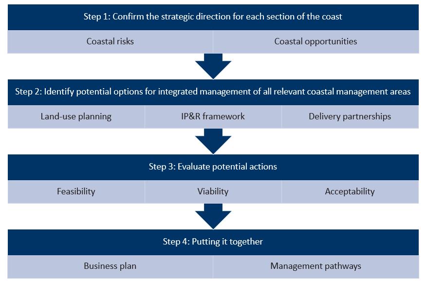
Identification and Evaluation of Coastal Management Options
This CMP provides a management framework that aims to protect the socio-economic, biodiversity and cultural values associated with the Port Stephens coastal zone, and to manage the potentially conflicting desires of protecting coastal biodiversity and enhancing recreational and economic opportunities.
There are many aspects of the management of the Port Stephens coastal zone that can be targeted through the coastal management framework, while some aspects are beyond the reach of this process. Development of management actions was focused on those mechanisms that are available through the CMP process and 10-year delivery timeframe.
As described in Section 3.1, a total of 158 potential management options spread across the Port Stephens coastal zone were compiled via an audit of previous management plans and studies, engagement with the community and agency stakeholders, and the outcomes of the Stage 2 CMP vulnerability assessments. There is a higher density of options in the Outer Port, reflective of the higher density of development and economic activity in this part of the study area, which results in a higher overall risk from coastal hazards and impacts of human activities on the coastal zone.
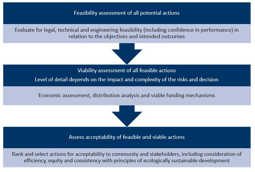
Initially, a feasibility assessment was undertaken to ‘rule out’ any options that did not address an existing or future risk to the coast, to consolidate overlapping options, or to identify options that were not feasible from an engineering, legal or implementation perspective. Feasible options progressed to a viability assessment, which involved a simple economic analysis and a multi-criteria analysis (MCA) The acceptability of the management option to the community, Council and key stakeholders was also considered. Management options that are feasible, viable and acceptable are included in this CMP.
Recommended Coastal Management Actions
The CMP provides a suite of coastal planning and management actions that have been developed and prioritised based on the assessment of threats and risk to the values associated with the study area, and with respect to how well the proposed actions addressed the CMP management objectives.
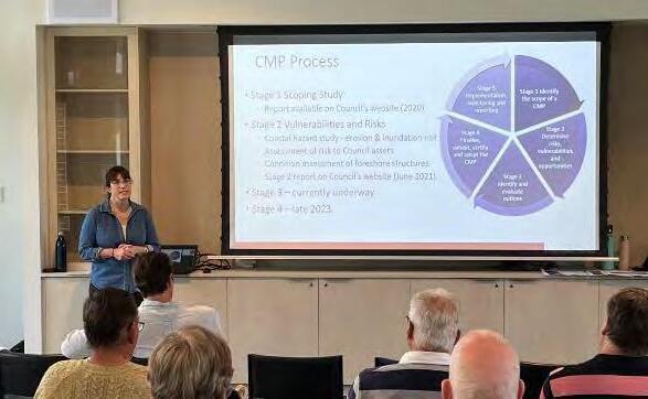
Photo: Community engagement session at Tomaree Sports Centre (M. Rosenthal, 2023)
Actions consist of a range of knowledge building activities, investigations and engineering designs, on-ground works, and monitoring programs. The CMP includes 67 management actions that have been grouped according to the key threat addressed by each action, although many actions address more than one threat and would also achieve a range of other benefits or positive outcomes.
Of the 67 management actions in the Port Stephens CMP, there are:
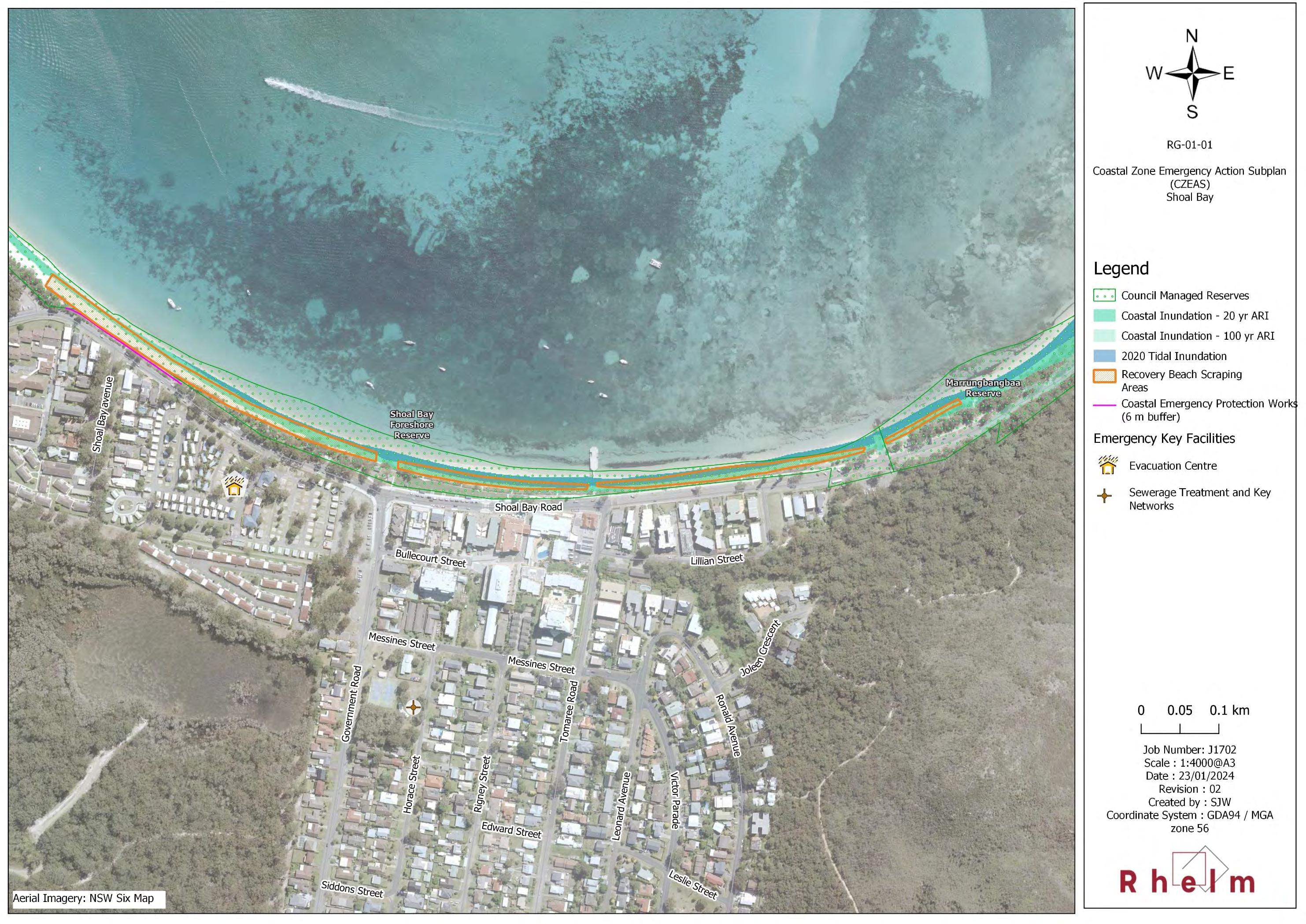
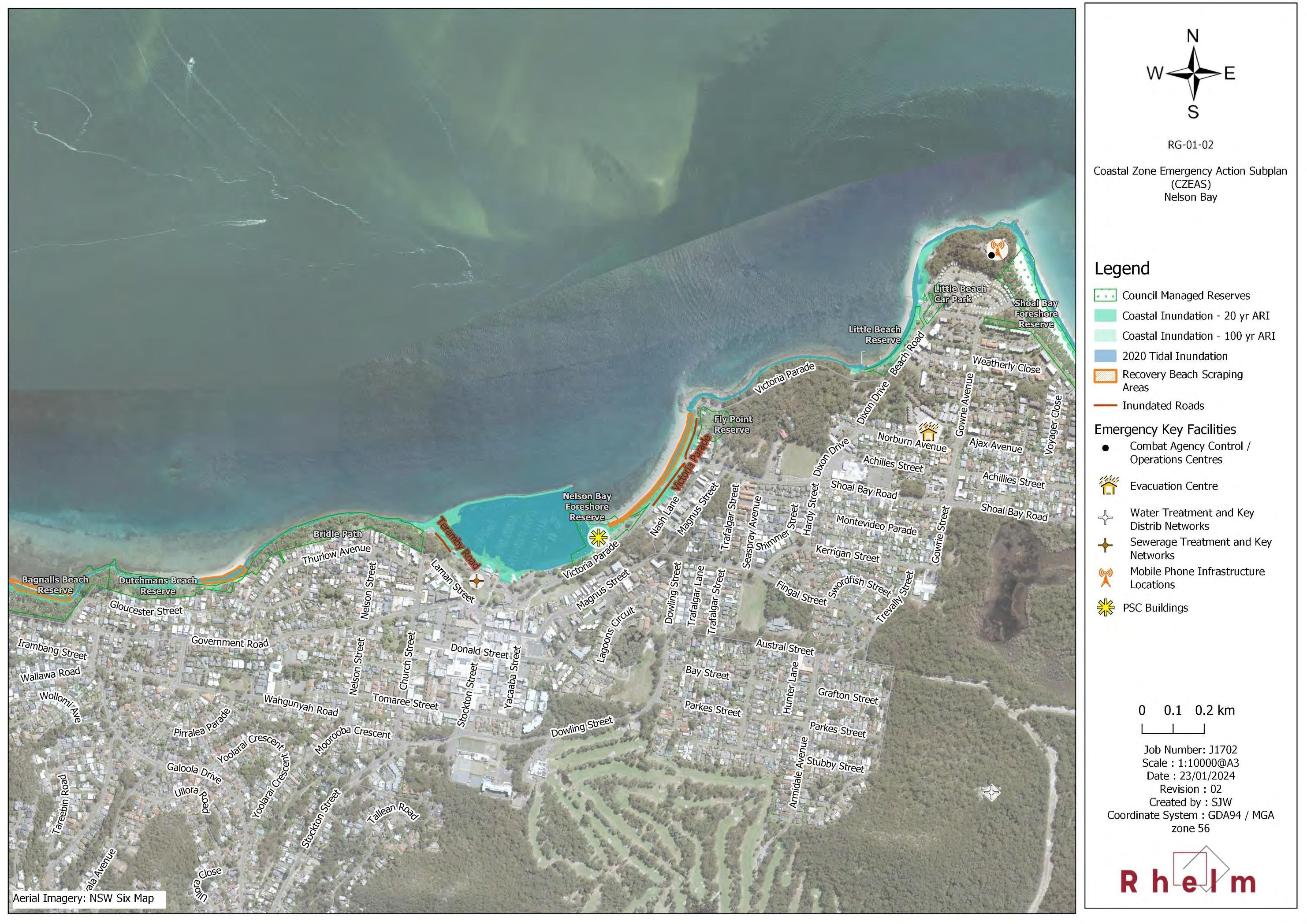
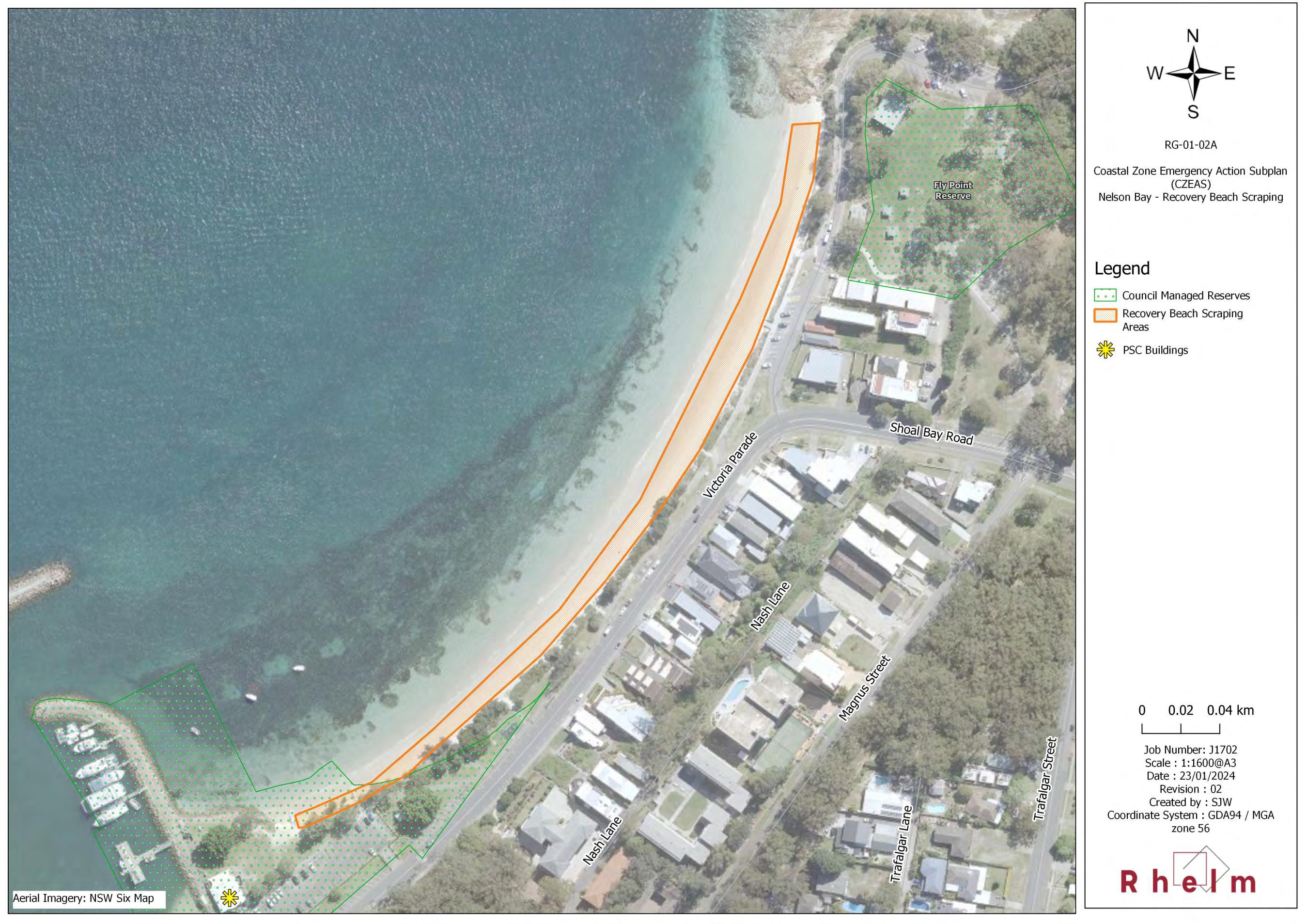
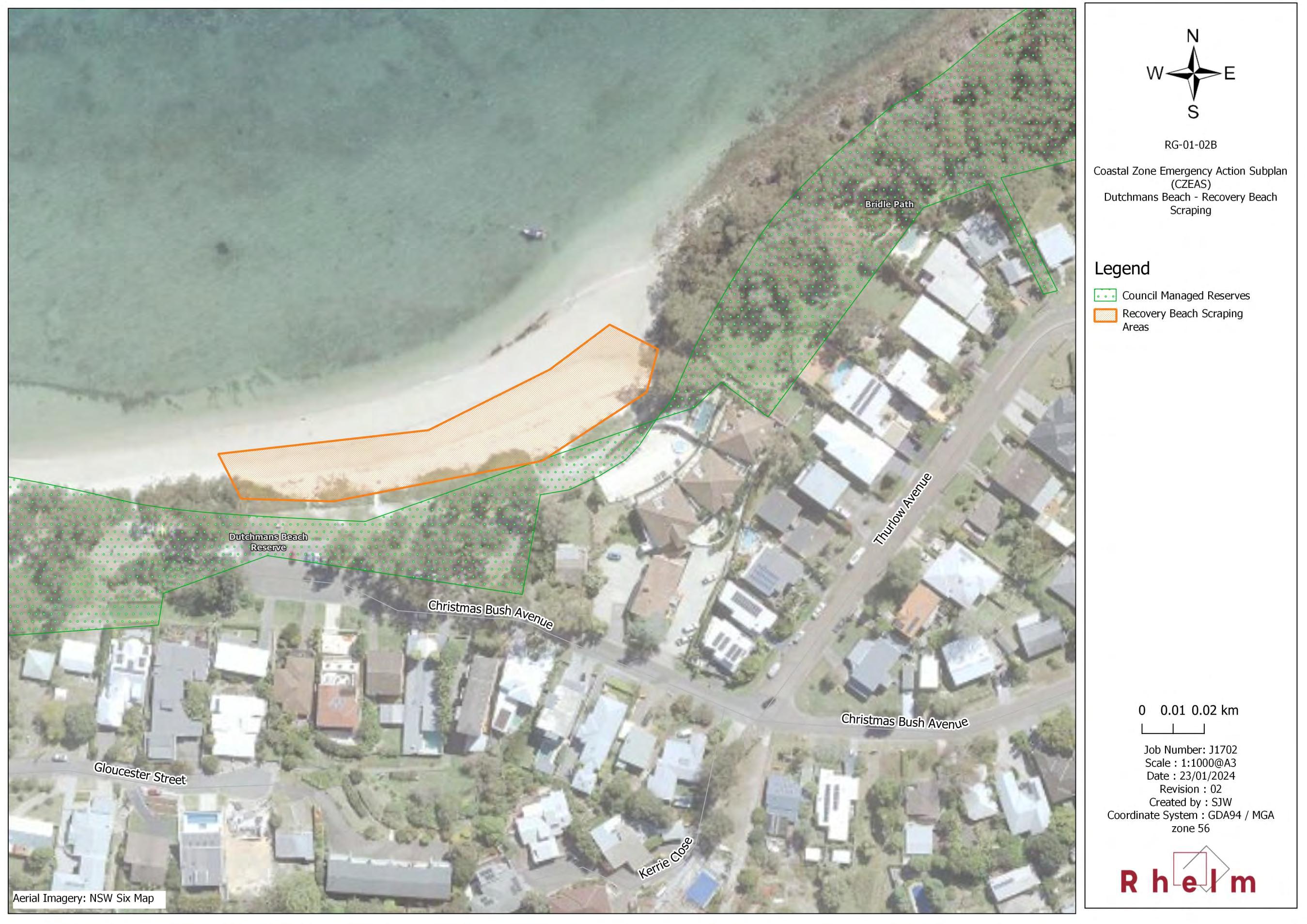
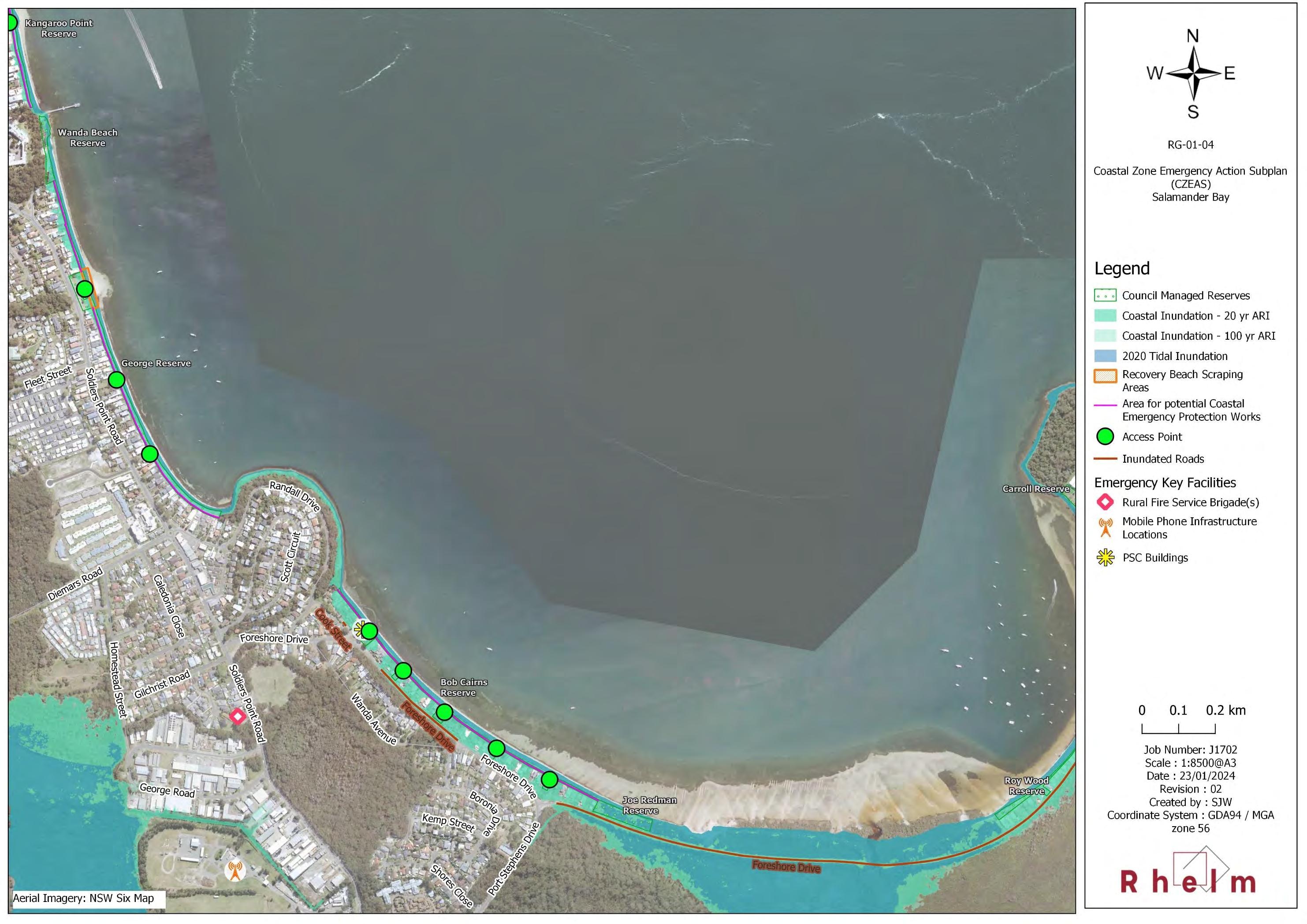
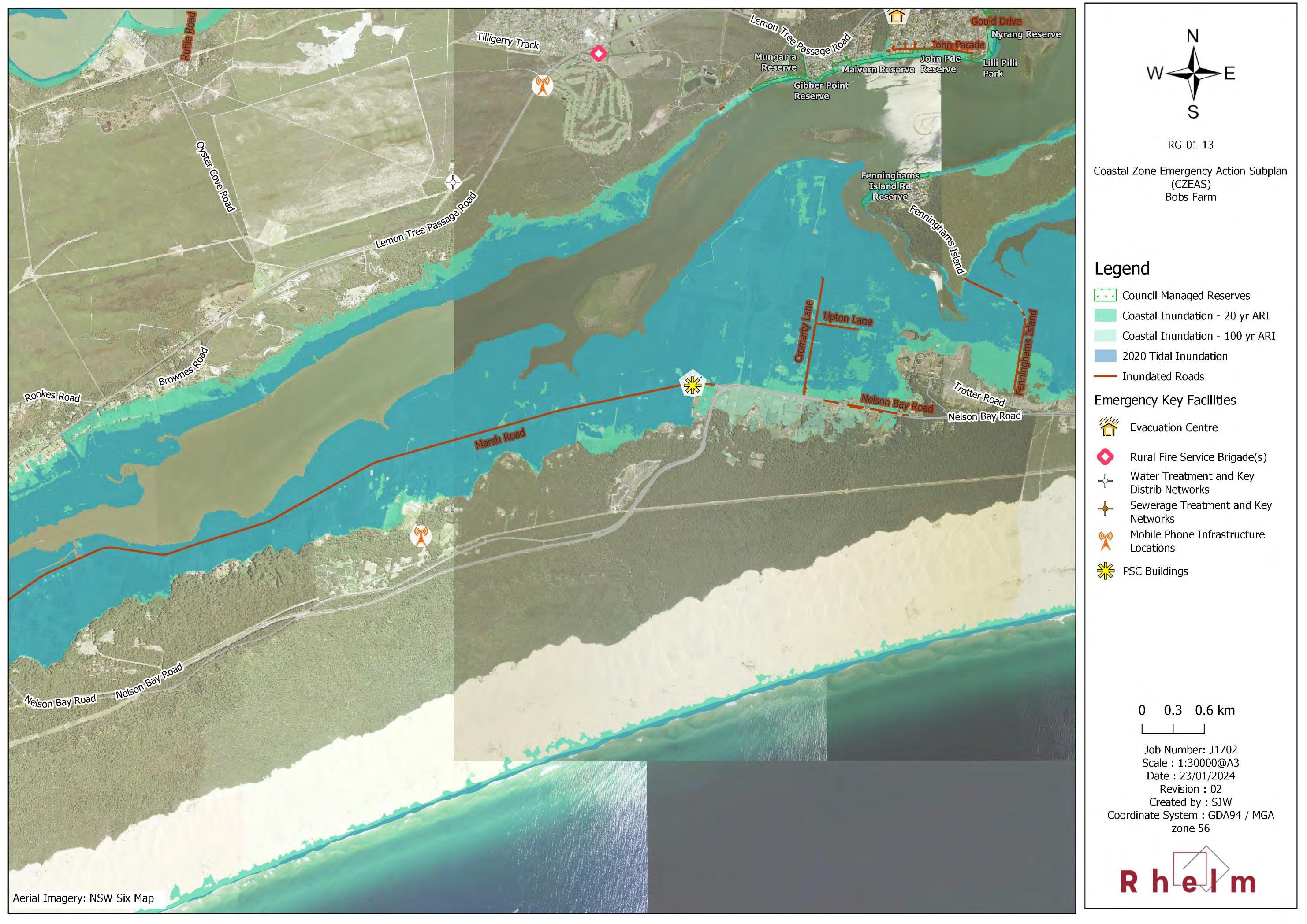
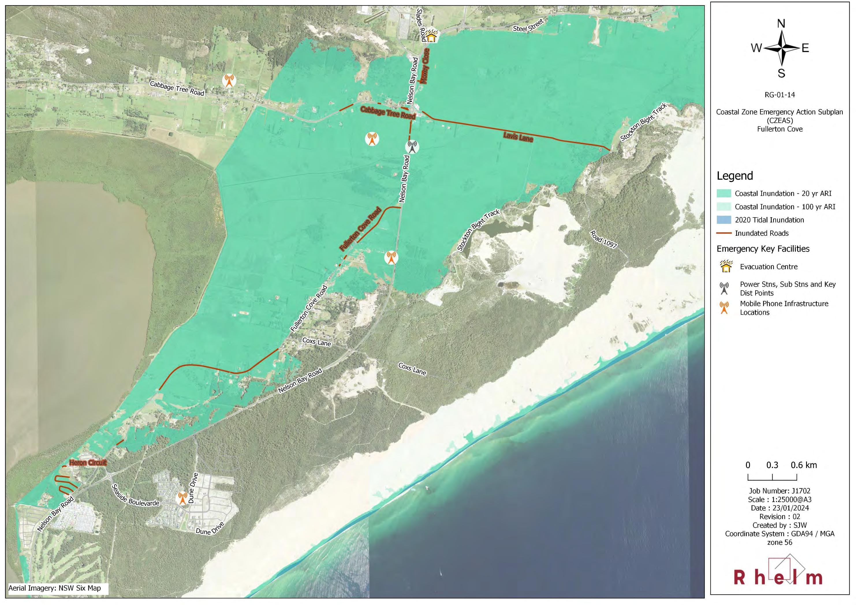
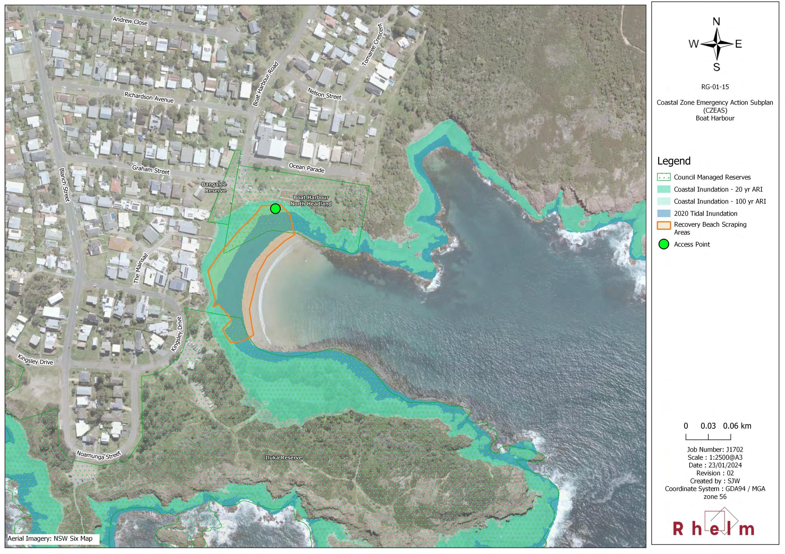
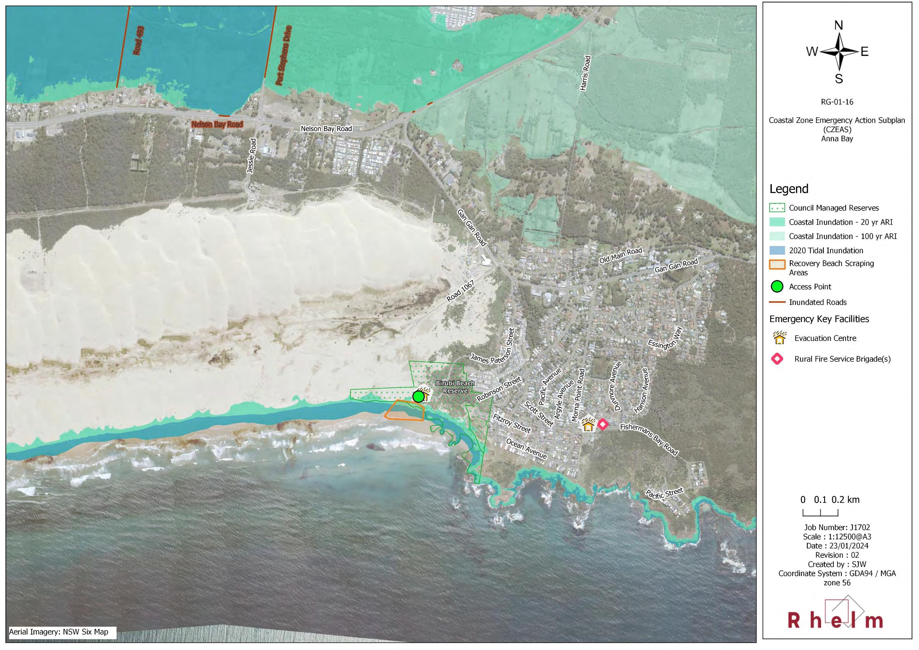
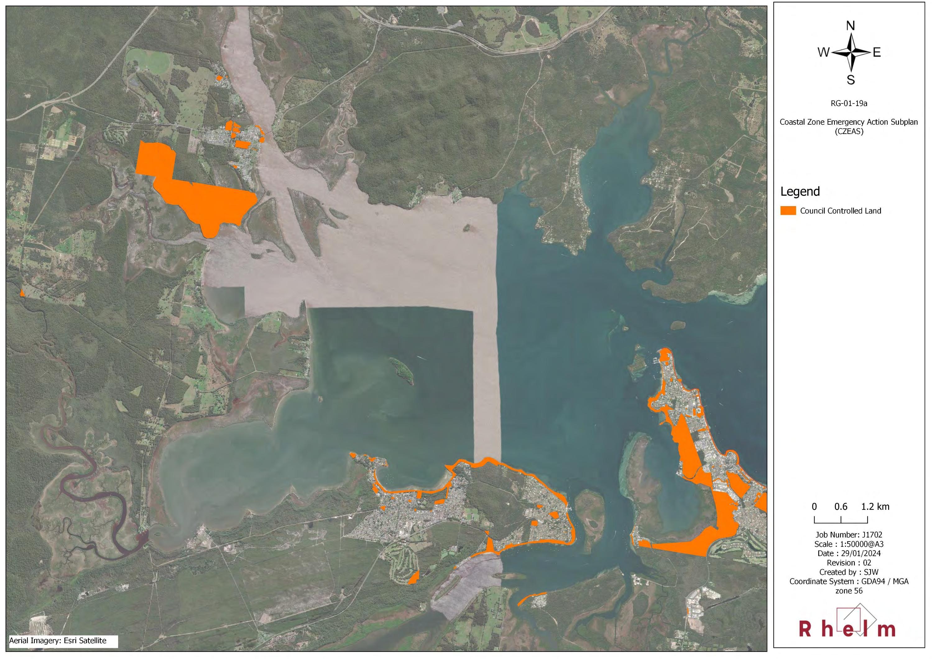
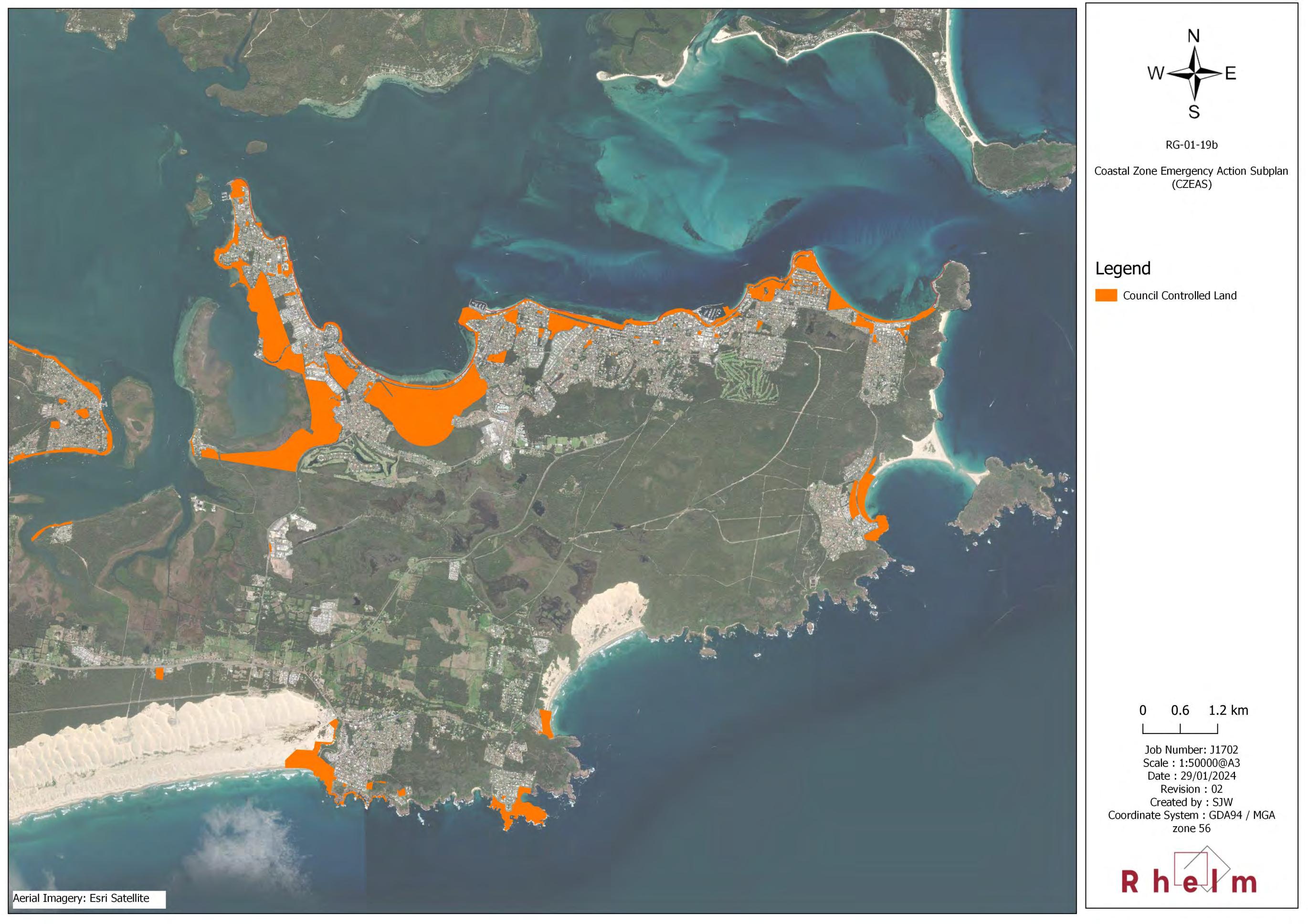
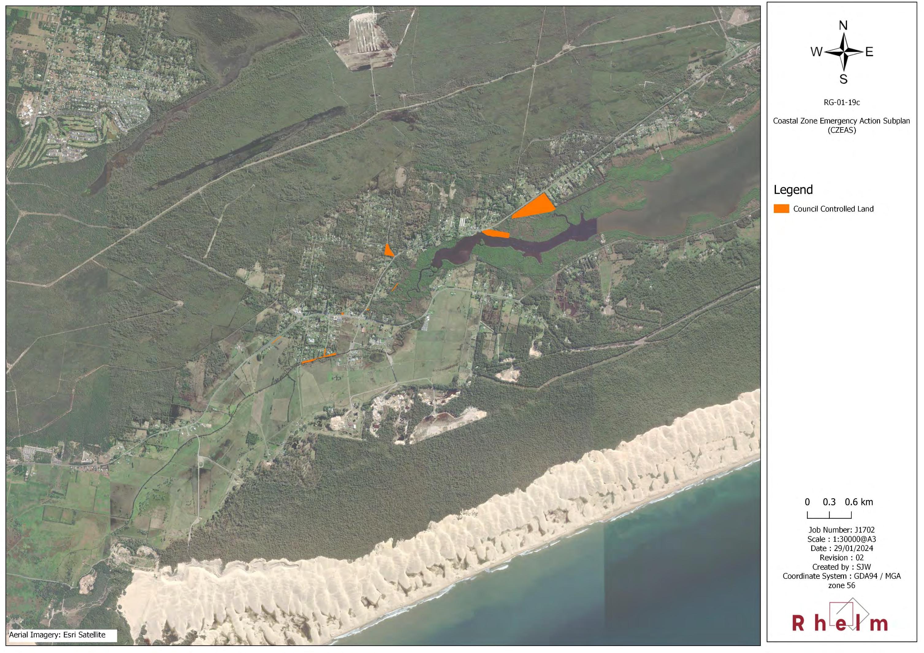
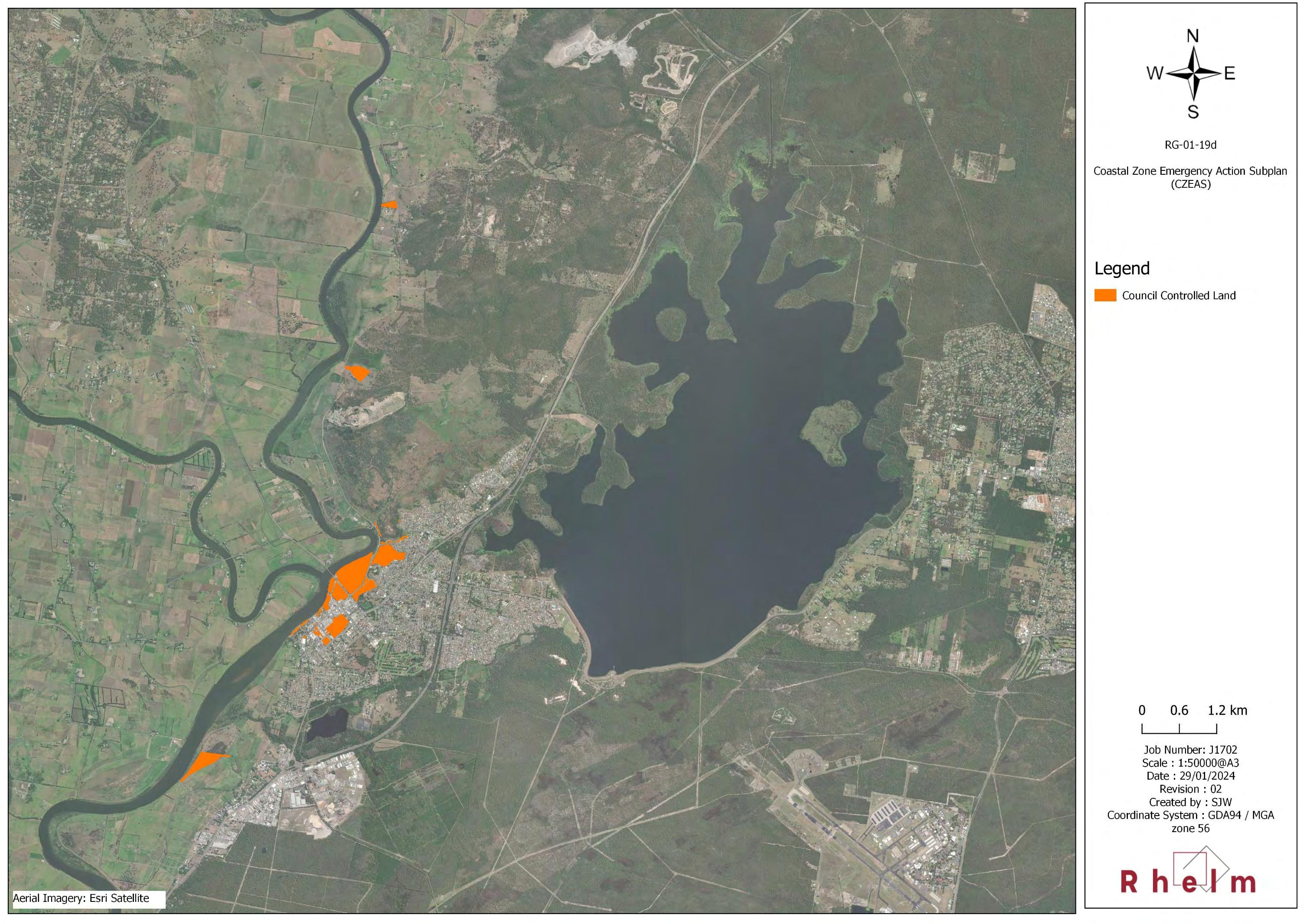
• 30 actions that address Coastal Hazard Threats, including one action that provides for implementation of the Coastal Zone Emergency Action Subplan (CZEAS);
• 17 actions that address Recreation and Access Threats;
• 10 actions that address Biodiversity Threats;
• 9 actions that address Water Quality Threats; and
• 1 action that addresses a Mining and Extractive Industries Threat.
The management actions for Council and those to be led by other stakeholders are identified in Section 3.2
There are also six actions that comprise the Monitoring Evaluation and Reporting (MER) program for this CMP. These are listed in Section 7.
On the basis of a planning review undertaken in Stage 3 of the CMP (Rhelm and Bluecoast, 2023; refer Section 4), the CMP includes a management action (Action CH011) to prepare a planning proposal to incorporate planning provisions and development controls to manage the risk to life and development arising from coastal hazards and dune transgression for inclusion in the Port Stephens Local Environmental Plan 2013 and Development Control Plan 2024 (respectively). The planning provisions will be supported by coastal and dune transgression risk planning area maps, which indicate the land subject to the development controls and have been included in Appendix E. In addition, Council has determined to proceed with adoption of a Coastal Vulnerability Area (CVA) for the LGA, as provided for under Action CH085. The proposed CVA will be consistent with the coastal risk planning area mapped in Appendix E
The Business Plan
A Business Plan has been developed for the CMP which outlines the key components of the funding strategy for the CMP, including the cost of proposed actions, proposed cost-sharing arrangements and other potential funding mechanisms (Section 5). Once the program is certified, Port Stephens Council will be responsible for facilitating the implementation of the program through its governance and budgetary processes. This will proceed using both specific staff resources and existing elements of the NSW Integrated Planning and Reporting (IP&R) Framework of Council to undertake, track and measure the success of actions in the CMP. Management actions have been developed for a 10-year period and have been aligned with Council’s fouryear Delivery Programs under the NSW IP&R Framework.
This CMP and the progress of the management actions will be reviewed periodically as detailed in Section 7 to ensure the actions remain relevant and the implementation of the program is being achieved.
Delivery of the Port Stephens CMP is estimated to cost $16.95 million (2023 dollars) over 10 years. The CMP actions are expected to be funded through Port Stephens Council and State Government contributions, monetary grants and volunteer works by community members and organisations. Port Stephens Council contribution is costed to be $7.05 million over 10 years, with anticipated State Government and agency contributions of $9.90 million over 10 years.
Table
Table
Appendices
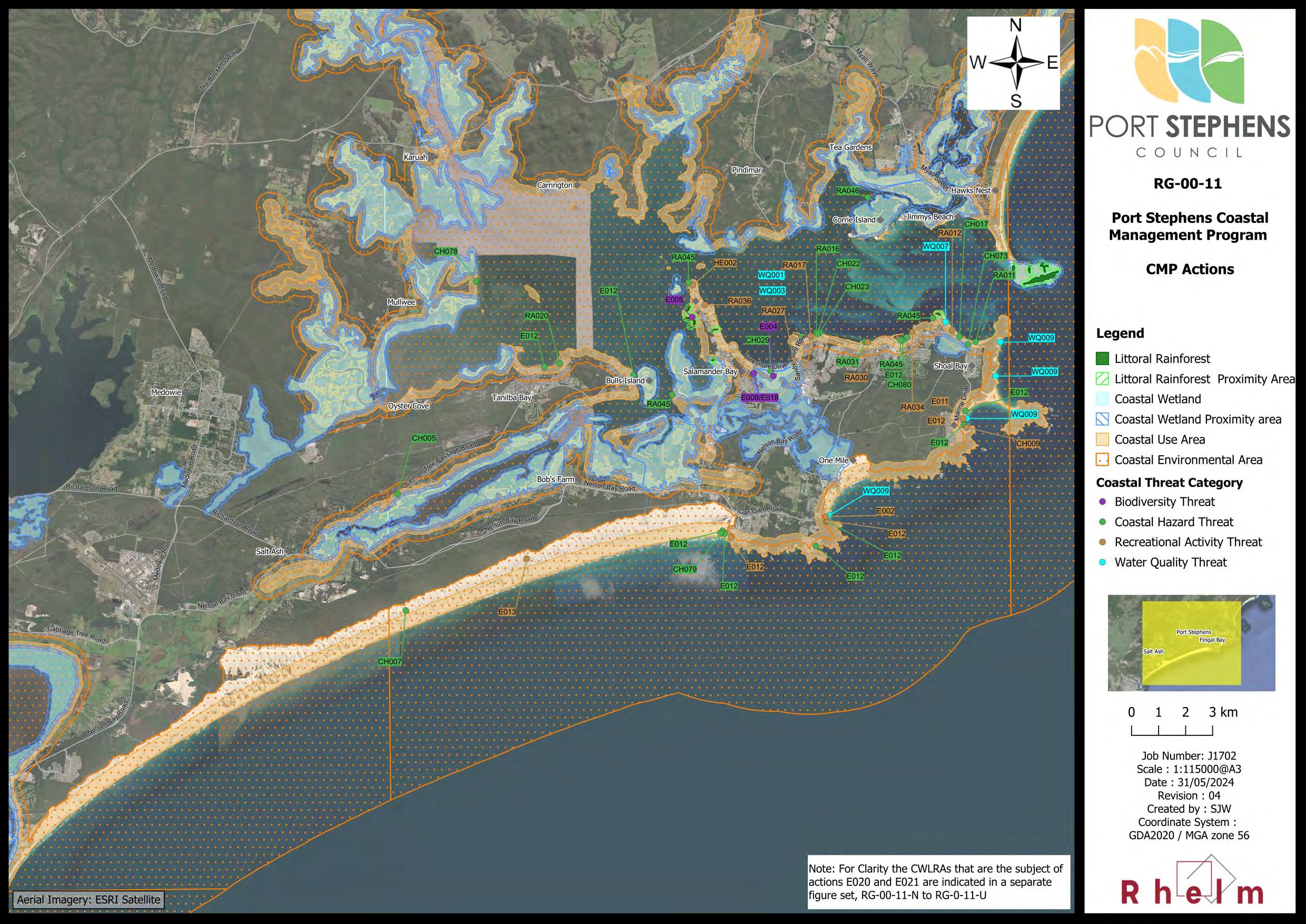
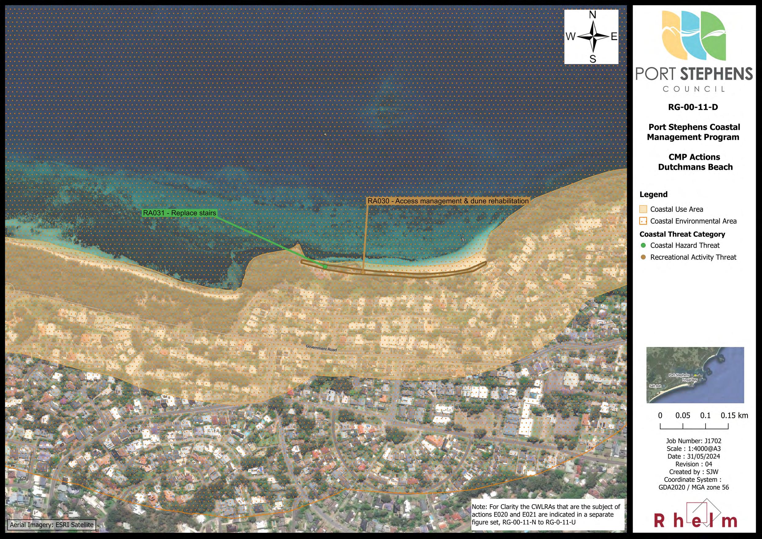
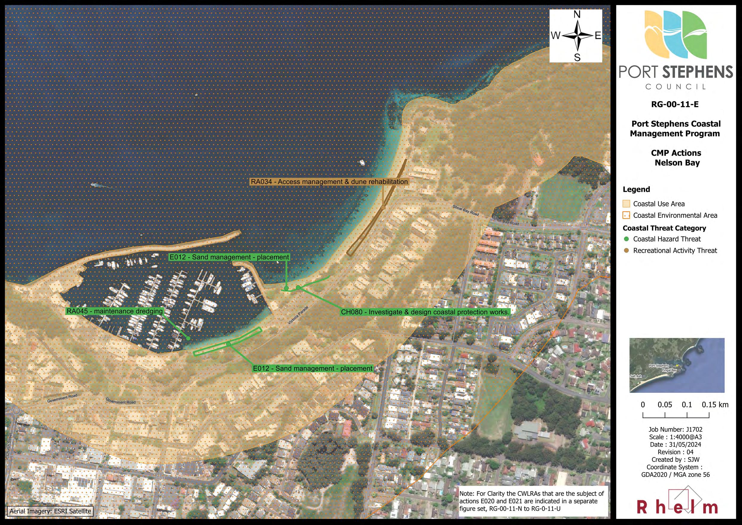
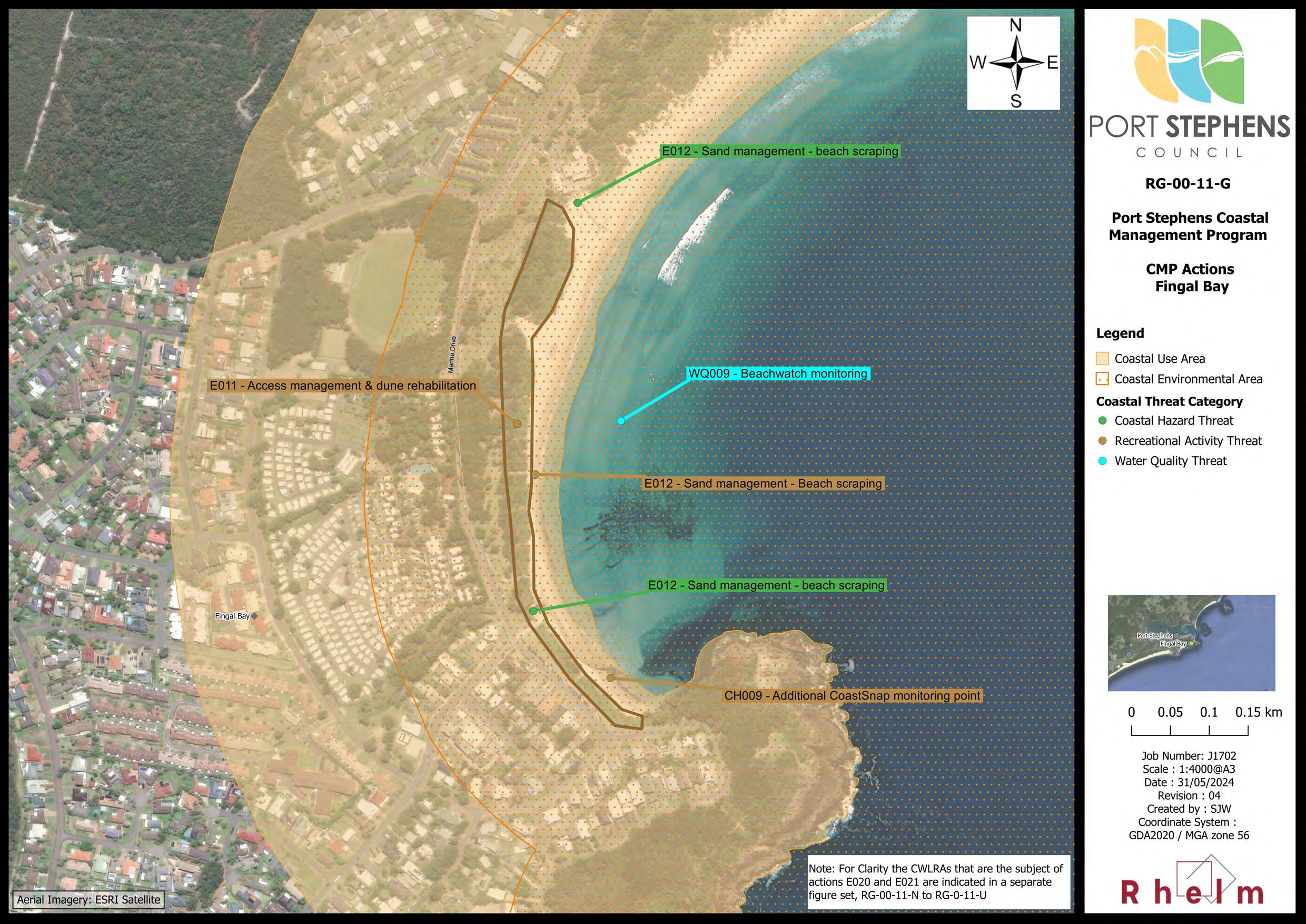
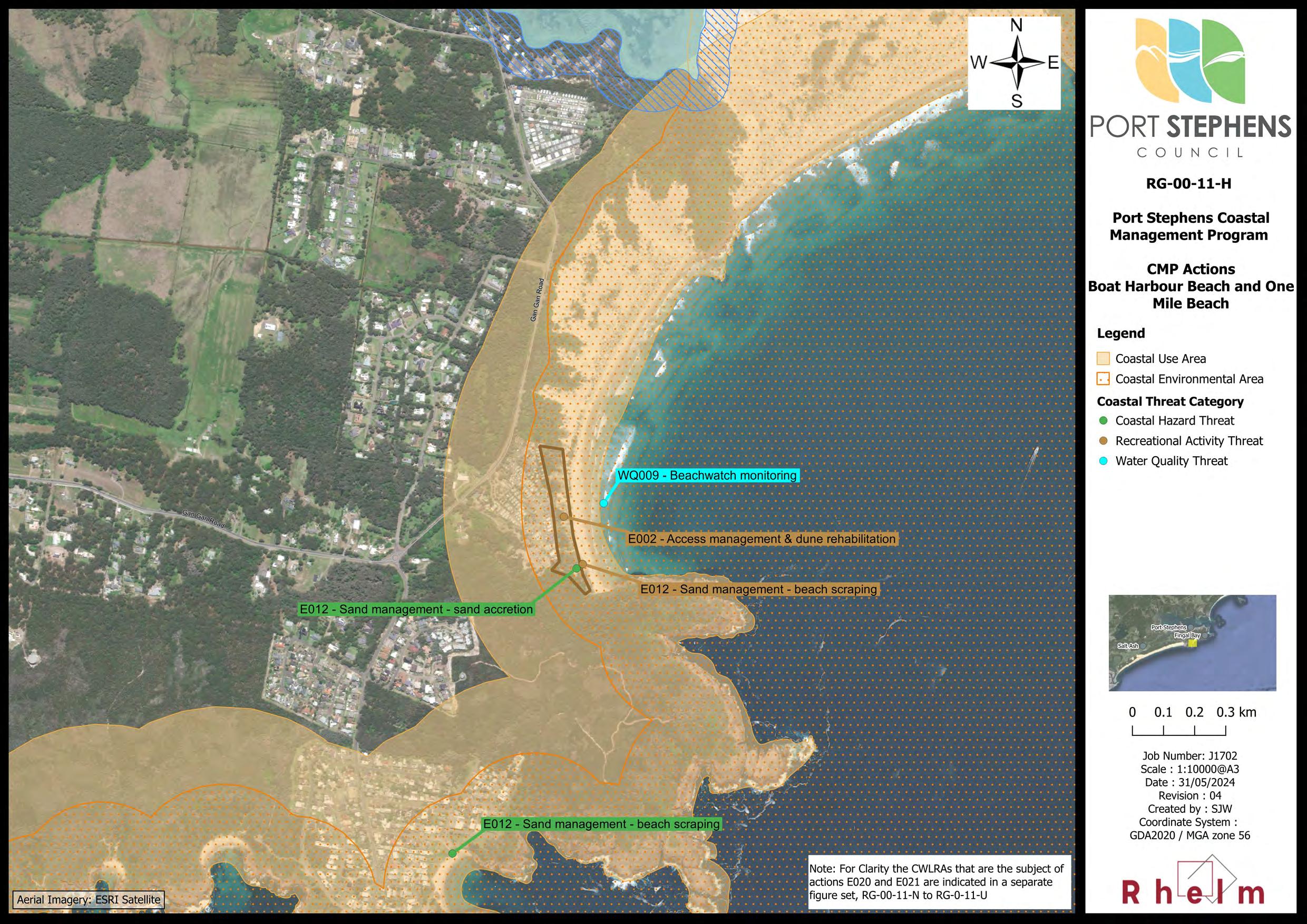
Appendix A – Map Compendium
Appendix B – Communications and Engagement Plan and Summary Report
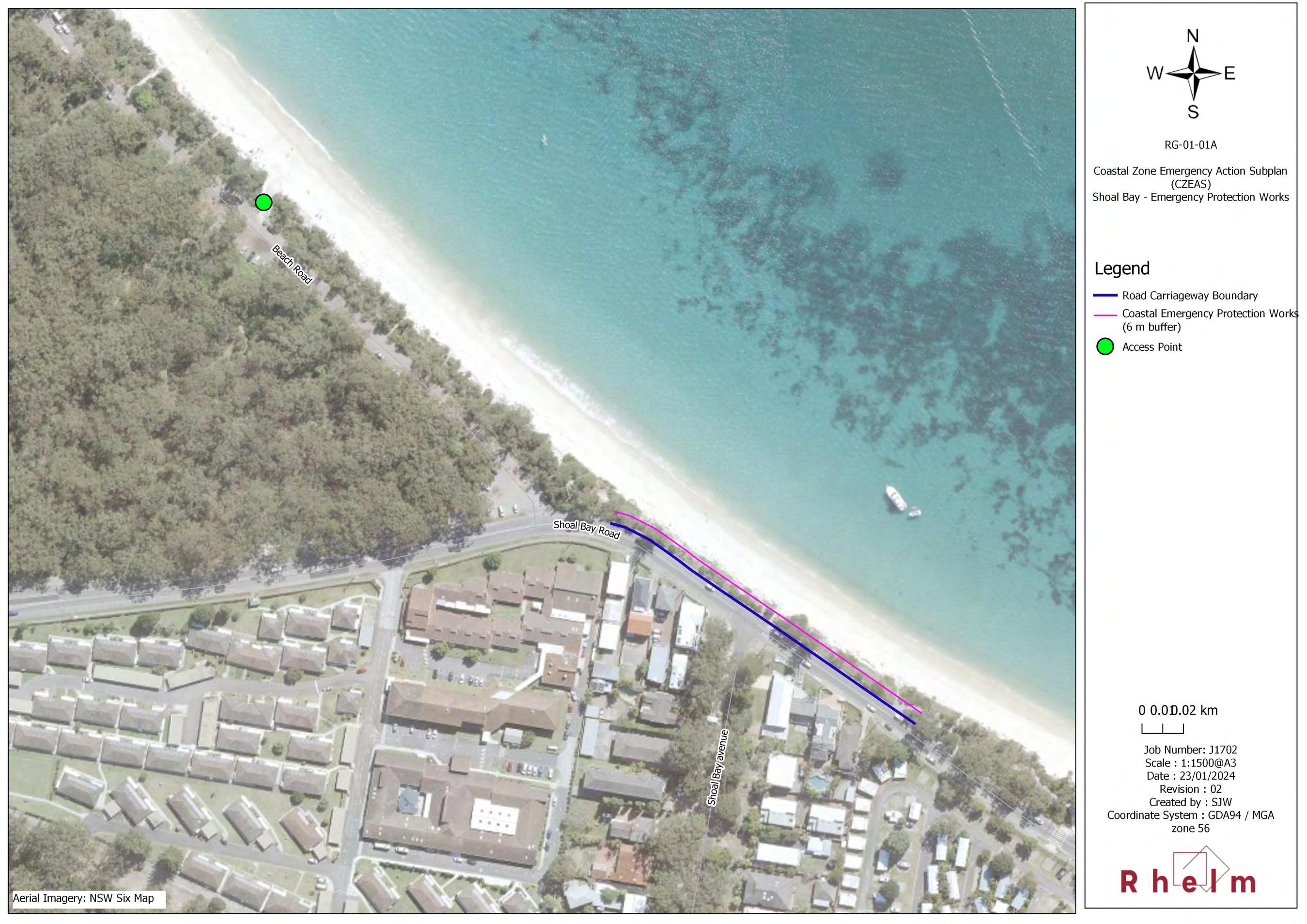
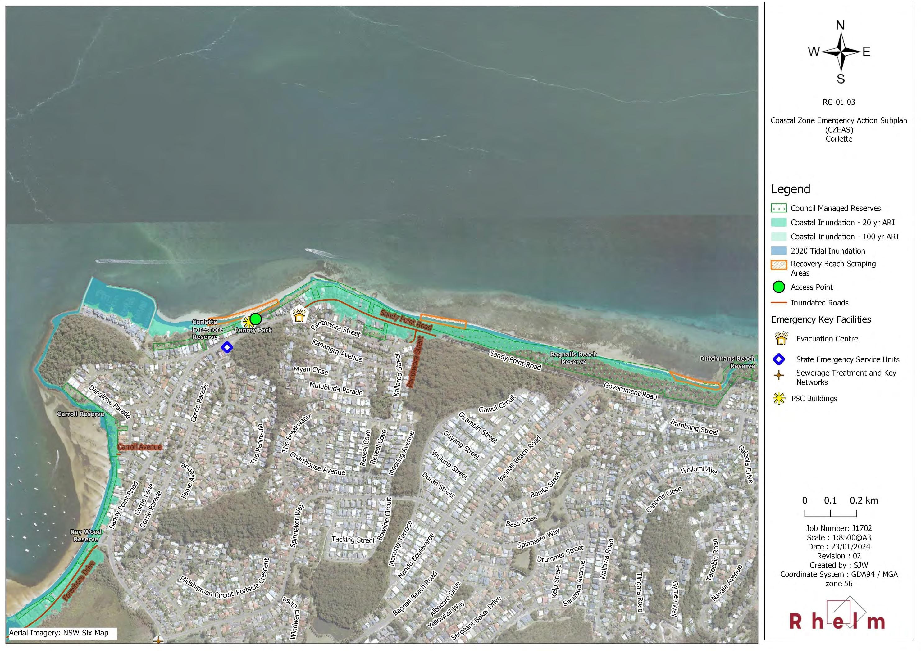
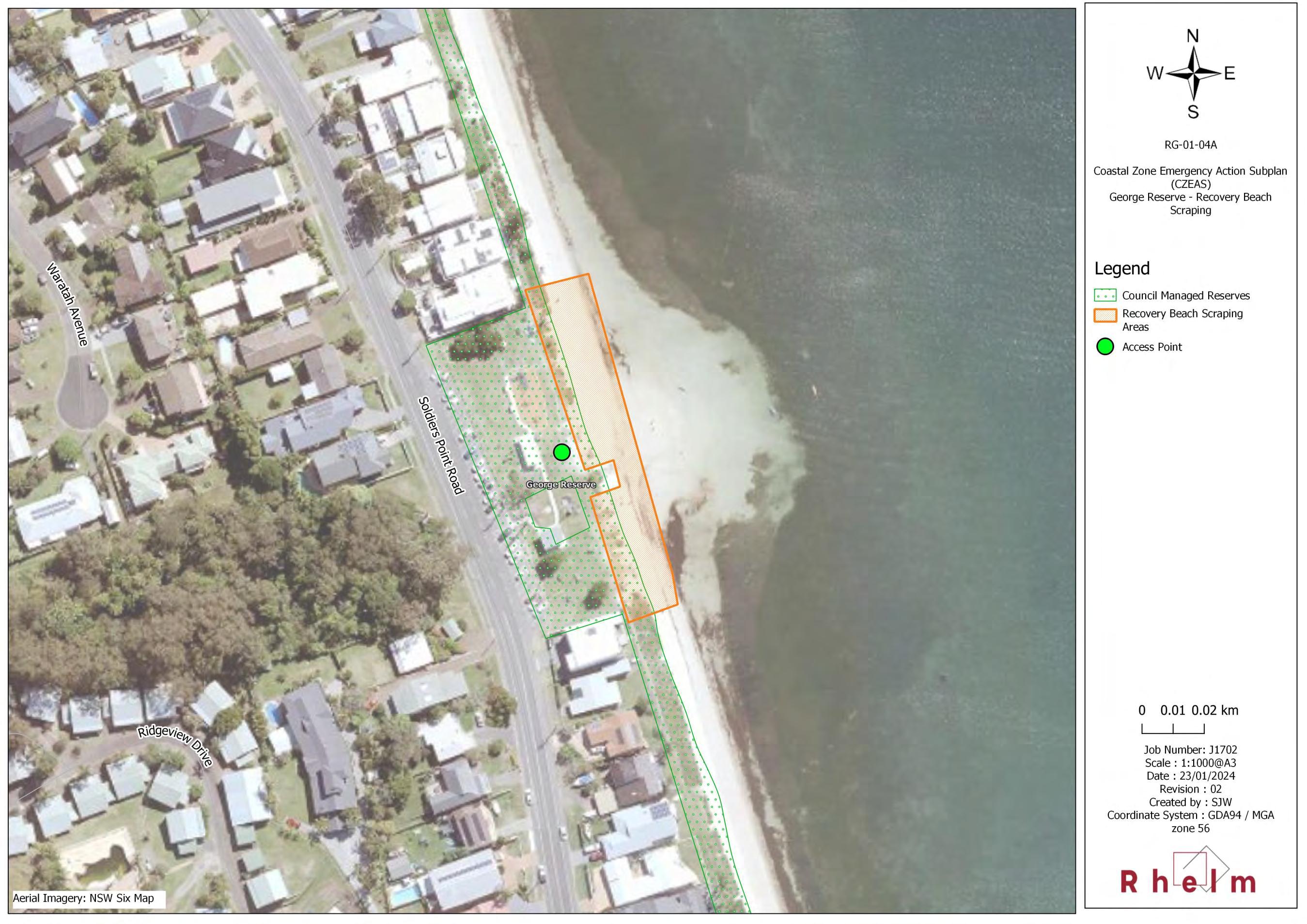
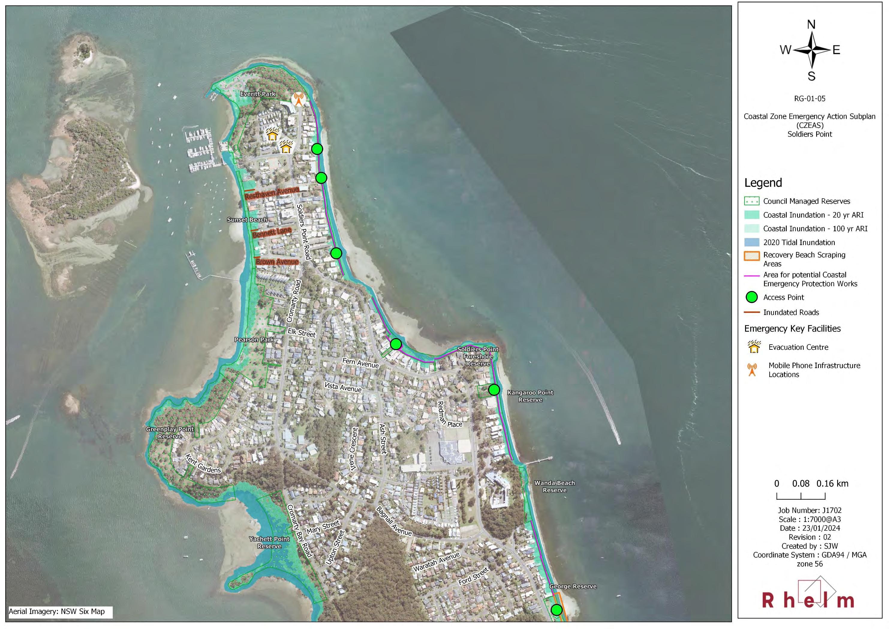
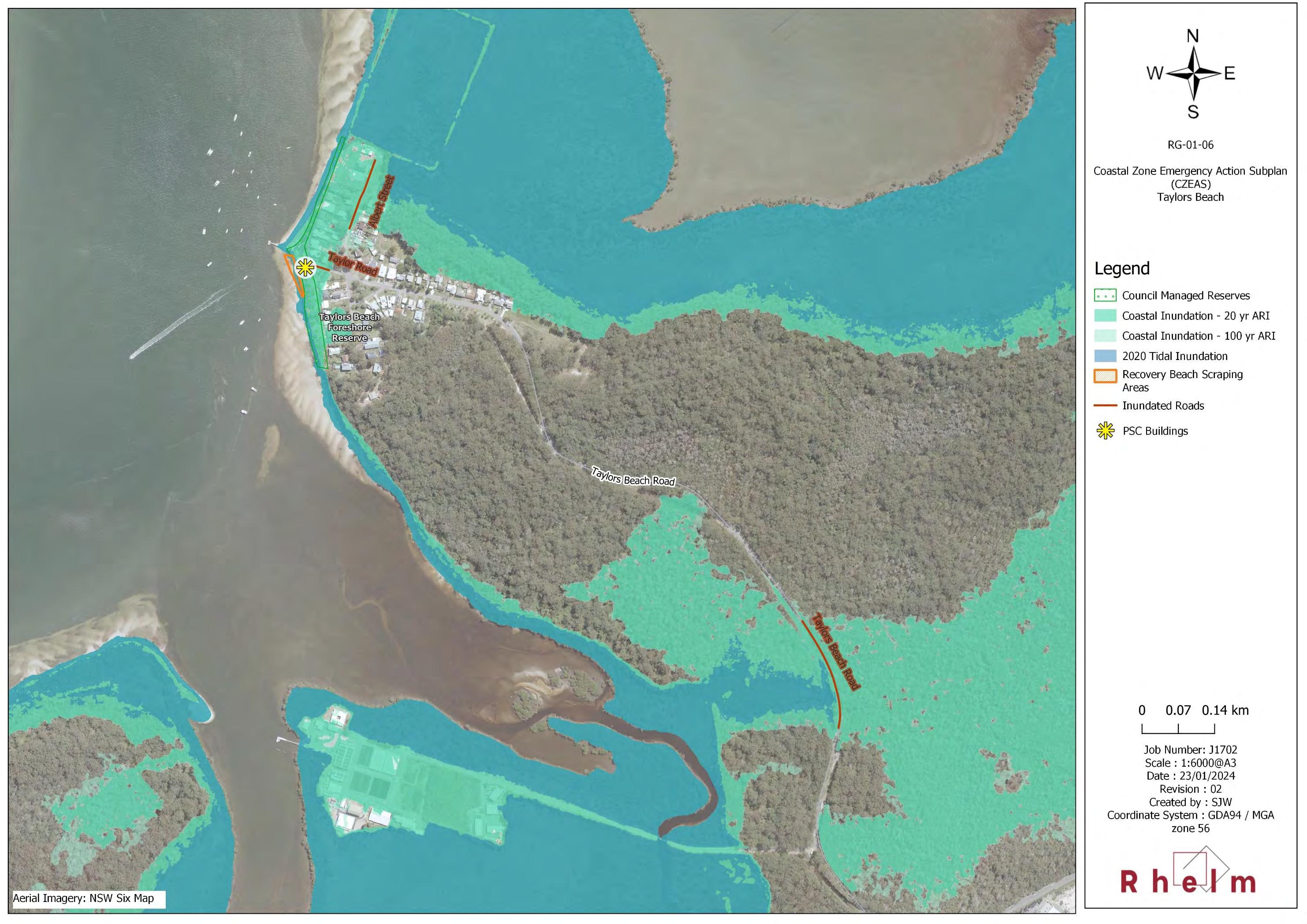
Appendix C – Coastal Zone Emergency Action Subplan
Appendix D – E012 – Sand Management Action Details
Appendix E – Mapping of Land Subject to Coastal Risk (or CVA) and Dune Transgression Risk
1 Introduction
Port Stephens Council (hereafter ‘Council’ or PSC) has, with the assistance of the NSW Department of Climate Change, Energy, the Environment and Water (NSW DCCEEW), prepared a Coastal Management Program (CMP) to provide strategic direction and specific actions to address threats to the coast and maintain the ecological, social and economic values of the Port Stephens coastal zone.
1.1 Purpose of the Port Stephens CMP
The State Government requires that CMPs be prepared in accordance with the mandatory requirements for CMPs specified in the Coastal Management Act 2016 (the CM Act) and accompanying NSW Coastal Management Manual (CM Manual; OEH, 2018b).
The CMP outlines the strategic aims for the coordinated management of the coastal zone and identifies specific actions to mitigate the threats and issues identified for the coast that are to be implemented over the next 10 years. The CMP is an operational document for the community and government to take action to manage, preserve, improve, promote and rehabilitate the coast.
In effect, the CMP is a plan of action for Council, public authorities and land managers responsible for management of the Port Stephens coastal zone to:
• Address coastal hazard risks;
• Preserve habitats and cultural uses and values;
• Encourage sustainable agricultural, economic and built development in the coastal zone;
• Maintain or improve recreational amenity and resilience; and
• Adapt to emerging issues such as population growth and climate change.
1.2 Strategic and Statutory Context
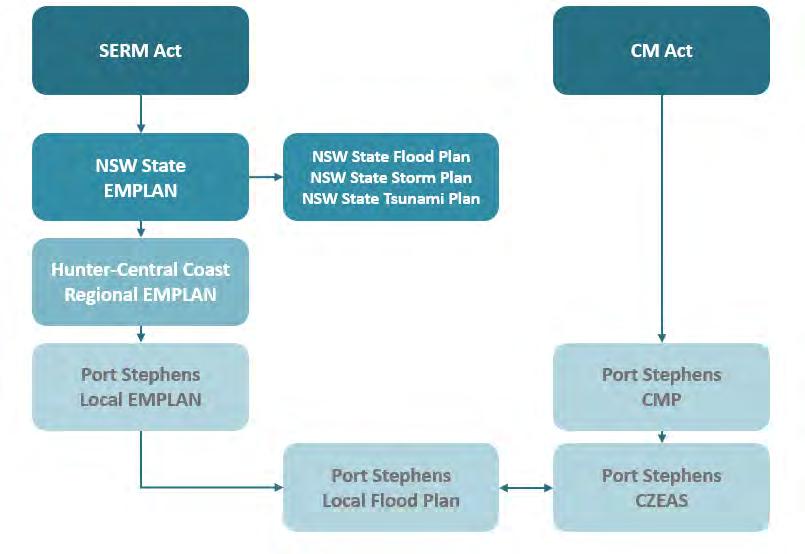
Under Part 3 of the CM Act, local Councils are required to prepare CMPs in accordance with the coastal management framework (Figure 1-1), which reflects the broader suite of statutory instruments and strategies that provide for the Ecologically Sustainable Development (ESD) of the coastal zone of NSW.
The CM Manual (OEH, 2018b) provides information and guidance to Councils in preparing their CMPs.
A CMP is prepared in five stages as illustrated in Figure 1-2. Previous stages that have been completed for the Port Stephens coastal zone to date include:
• Coastal Management Program Stage 1 Scoping Study (PSC, 2020), which set the context and scope for the CMP, including evaluation of threats to the Port Stephens coastal zone;
• Port Stephens Coastal Management Program – Stage 2 (BMT, 2021a), which involved a range of coastal hazard and risk assessments to fill existing knowledge gaps; and
• Port Stephens Coastal Management Program –Stage 3 Report (Rhelm and Bluecoast, 2023), which details the outcomes of the options identification and evaluation process, including the community and stakeholder engagement undertaken in Stage 3 of the CMP.
This document constitutes Stage 4 of the CMP process.
1.3 Area Covered by this CMP
Rationale for the CMP Study Area
The extent of the study area for the Port Stephens CMP was defined in consultation with key stakeholders (including the former DPE (now NSW DCCEEW) and the councils with adjacent coastline) during the Stage 1 Scoping Study (PSC, 2020). At that time Council determined that they would prepare one CMP for the coastal zone of the Port Stephens Local Government Area (LGA), extending from Fern Bay in the south to Yacaaba Headland in the north, and including the Port Stephens estuary.
The primary rationale for defining the study area as such was the desire to prepare a single CMP for the LGA, noting that Port Stephens Council had not previously progressed through the NSW Coastal Management
Figure 1-2 Stages in Preparing and Implementing a CMP (after: OEH, 2018b)
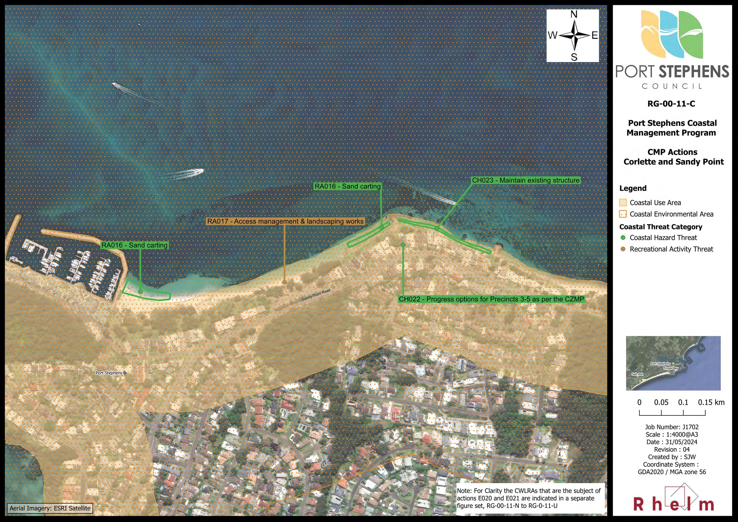
Framework and therefore did not have a holistic and comprehensive understanding of the risk from coastal hazards to public safety, built and natural assets. Nor was there any CMP or Coastal Zone Management Plan (CZMP) prepared in compliance with the CM Act in place for any part of the LGA, leaving a gap with respect to the requirements of the CM Act. The one exception is a single site-specific management plan, the Sandy Point / Conroy Park Foreshore Erosion and Drainage Management Plan (Whitehead and Assoc., 2015), which was certified by the Minister as a Coastal Zone Management Plan (CZMP) 2. In acknowledgement of the need to promptly address this gap, Port Stephens Council decided to proceed with a CMP that related solely to the Port Stephens LGA.
The secondary consideration in defining the Port Stephens CMP study area was the understanding that a separate CMP would be prepared for those portions of the coastal zone within the LGA falling within the catchment of the Hunter River estuary, and that therefore these parts of the coastal zone (which include the Hunter River and Fullerton Cove) should be excluded from the study area. Further, in discussion with MidCoast Council (MCC) it was agreed that the boundary of the Port Stephens CMP study area where it abuts the MidCoast LGA should be moved seaward to accommodate any potential management actions in the waterway identified during the development of the Southern Estuaries and Open Coasts CMPs by MidCoast Council.
Port Stephens CMP Study Area
The Port Stephens CMP study area encompasses the Open Coast, Outer Port and Inner Port areas as shown on Map RG-00-01 in Appendix A As discussed in the Scoping Study (PSC, 2020), each of these three regions within the broader study area (the Open Coast, Inner Port and Outer Port) differ with respect to their exposure and vulnerability to different types of coastal hazards and their environmental and social values and uses.
The landward extent of the study area is defined by the Coastal Management Areas (CMAs) mapped in the State Environmental Planning Policy (Resilience and Hazards) 2021 (the Resilience and Hazards SEPP). Along the northern shoreline, the landward extent is generally defined by a nominal 150 m buffer seaward of the gazetted LGA boundary.
While the Port Stephens waterway falls within the Port Stephens CMP study area, in practical terms, management of the Inner and Outer Port is shared across several stakeholders including both PSC and MCC, as well as Transport for NSW (TfNSW), Crown Lands and Public Spaces with the Department of Planning, Housing and Infrastructure (DPHI), and Department of Primary Industries (DPI) – Marine Parks. Ongoing communication and coordination between these stakeholders would be undertaken with respect to waterway management under this CMP and other existing mechanisms (e.g. the Port Stephens-Great Lakes Marine Park Advisory Committee, to which PSC is a member).
Status of CMPs for Adjacent Coastline
For that portion of the coastal zone falling within the Port Stephens LGA boundary that lies within the Hunter River estuary catchment (and including Fullerton Cove), a separate CMP is being progressed. The Hunter River Estuary CMP is being delivered by the Hunter Estuary Alliance, which is led by Maitland City Council and includes Port Stephens Council, City of Newcastle, Cessnock City Council, Dungog Shire Council, Hunter Water Corporation and the NSW Government.
Separate CMPs are also being progressed by MCC for their LGA. MCC is currently in the process of developing a CMP for its Southern Estuaries. The CMP will address key catchments throughout the MidCoast LGA including
2 This CZMP expired under the CM Act transitional arrangements on 31 December 2023 and no longer has statutory effect.
the Karuah River, North Arm Cove, Myall River and Kore Kore Creek catchments which form the northern foreshore of the Port Stephens estuary. In addition, MCC is also in the process of preparing the MidCoast Open Coast CMP, which will include Jimmys Beach.
Work on the Southern Estuaries and Open Coast CMPs commenced after the Port Stephens CMP had been substantially progressed. As agreed by MCC and PSC, the northern boundary of the Port Stephens CMP has generally been delimited by a nominal 150 m buffer seaward of the LGA boundary, which lies generally along the northern shoreline. This delineation seeks to accommodate the future CMPs being prepared by MCC
The interfaces of these CMPs with the Port Stephens CMP are indicated in Map RG-00-01 in Appendix A
1.3.1 Coastal Management Areas Included in the CMP
There are four CMAs defined under the CM Act. All four CMAs, as mapped under State Environmental Planning Policy (Resilience and Hazards) 2021 (hereafter the Resilience and Hazards SEPP). Three of these CMAs are mapped for the study area and therefore fall within the scope of the Port Stephens CMP:
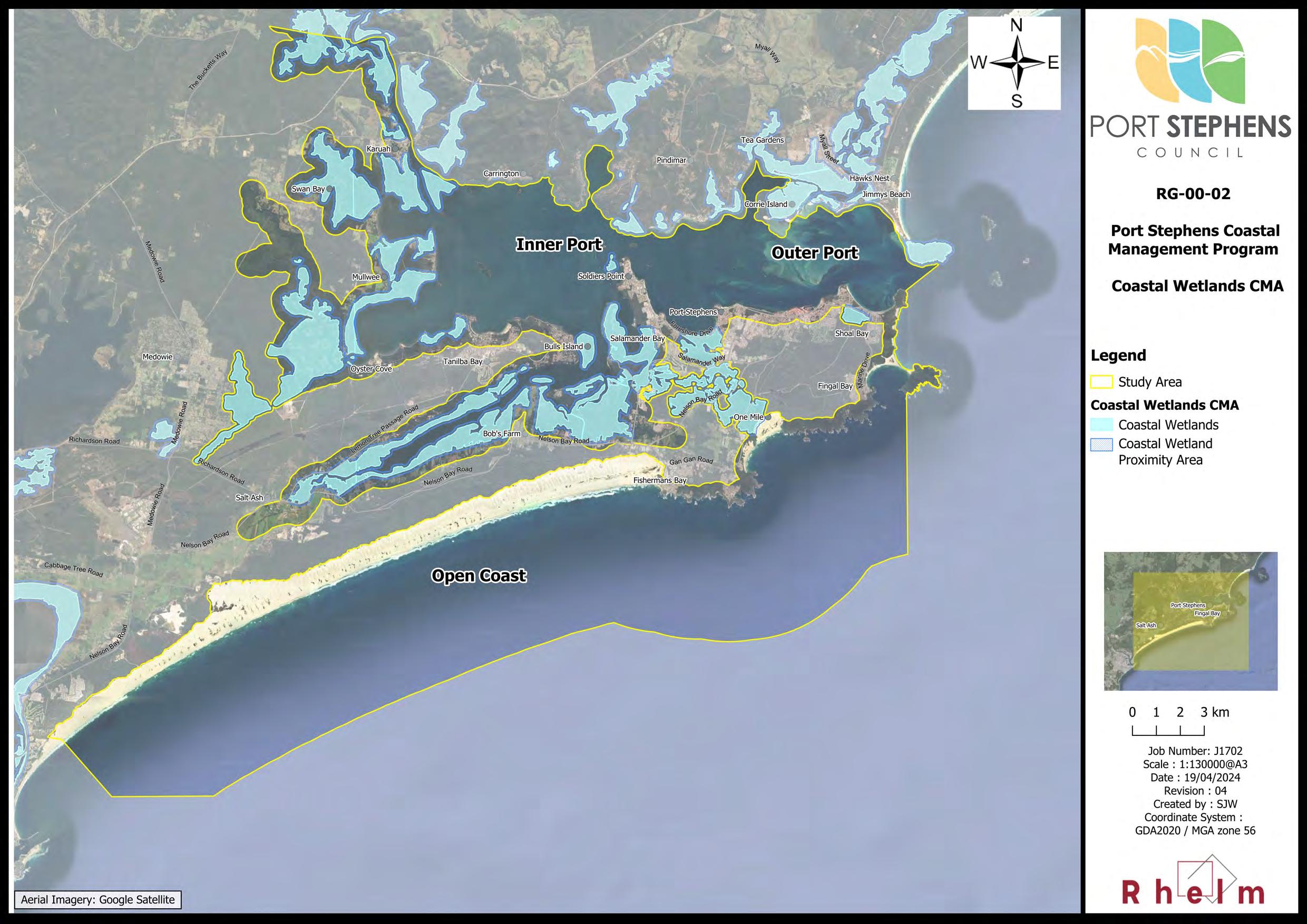
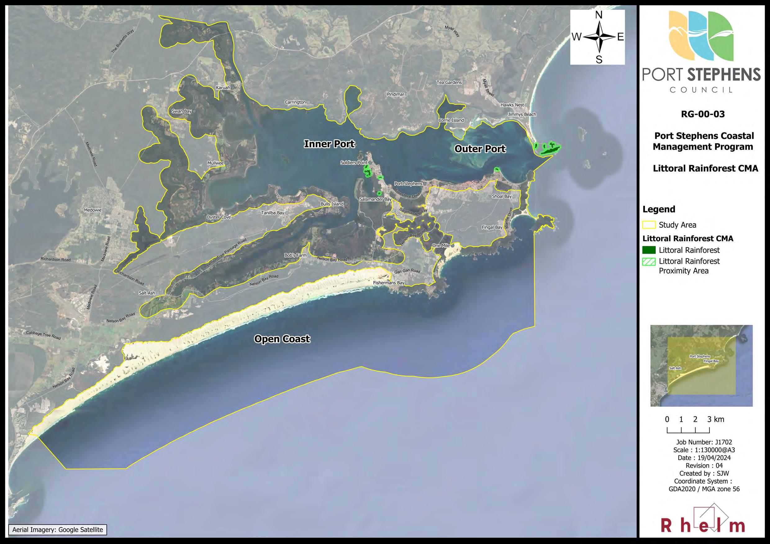
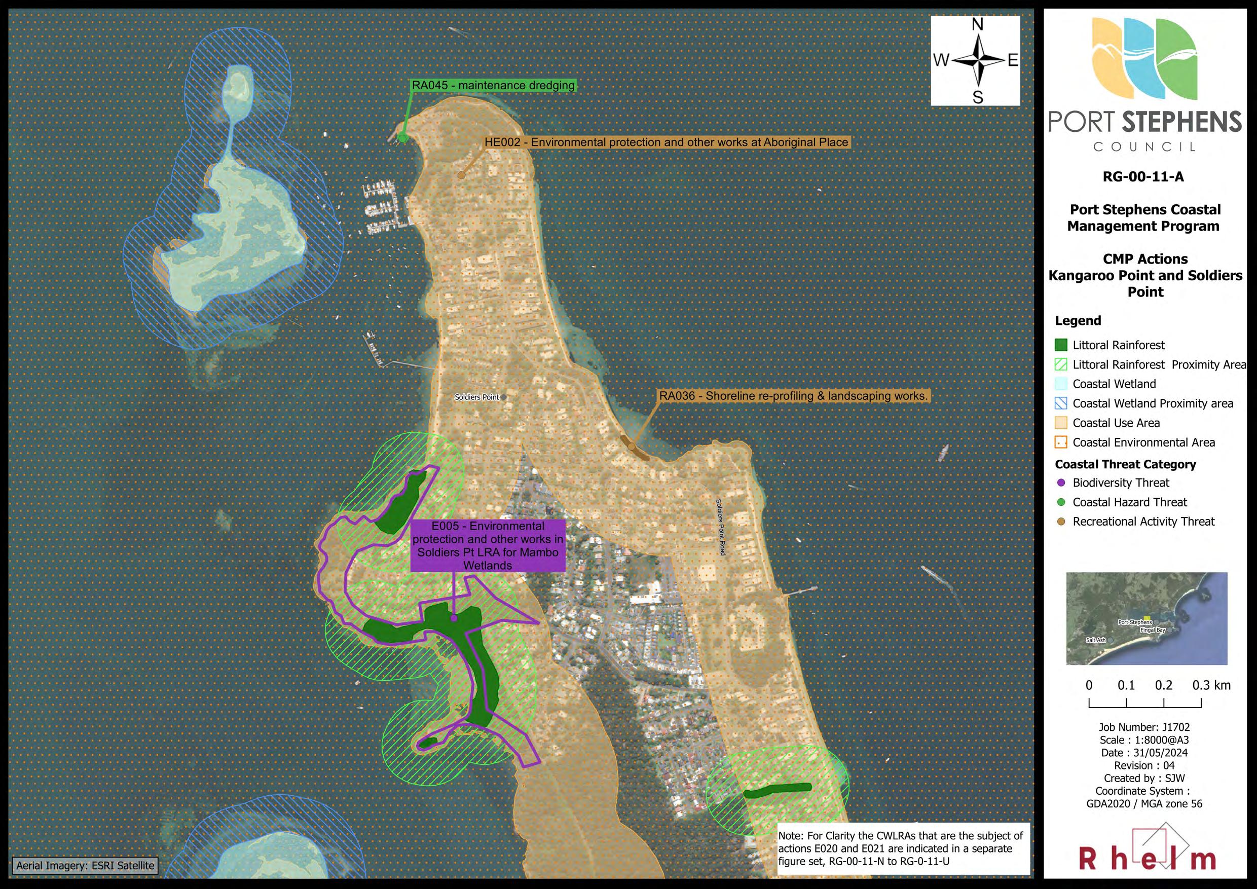
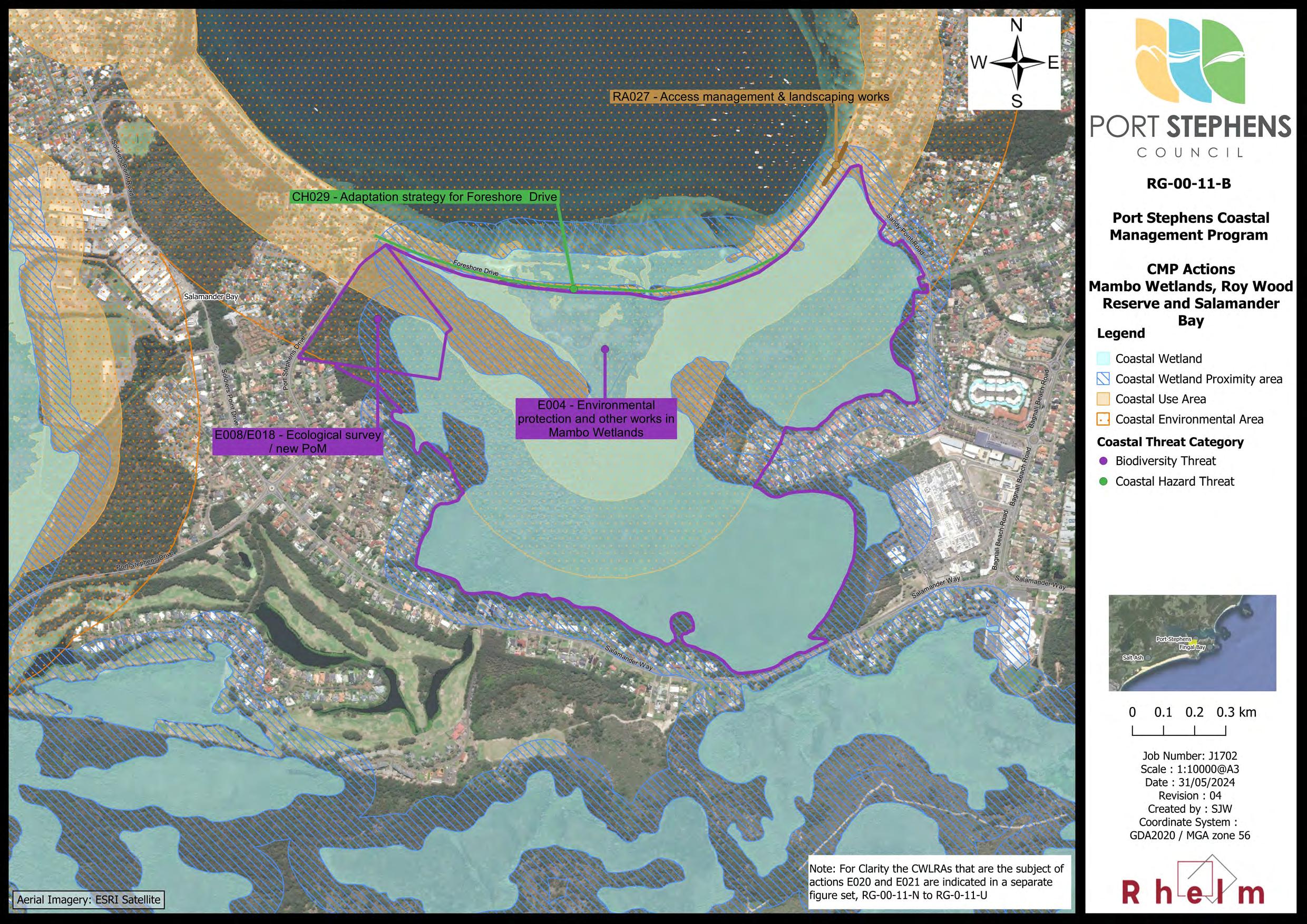
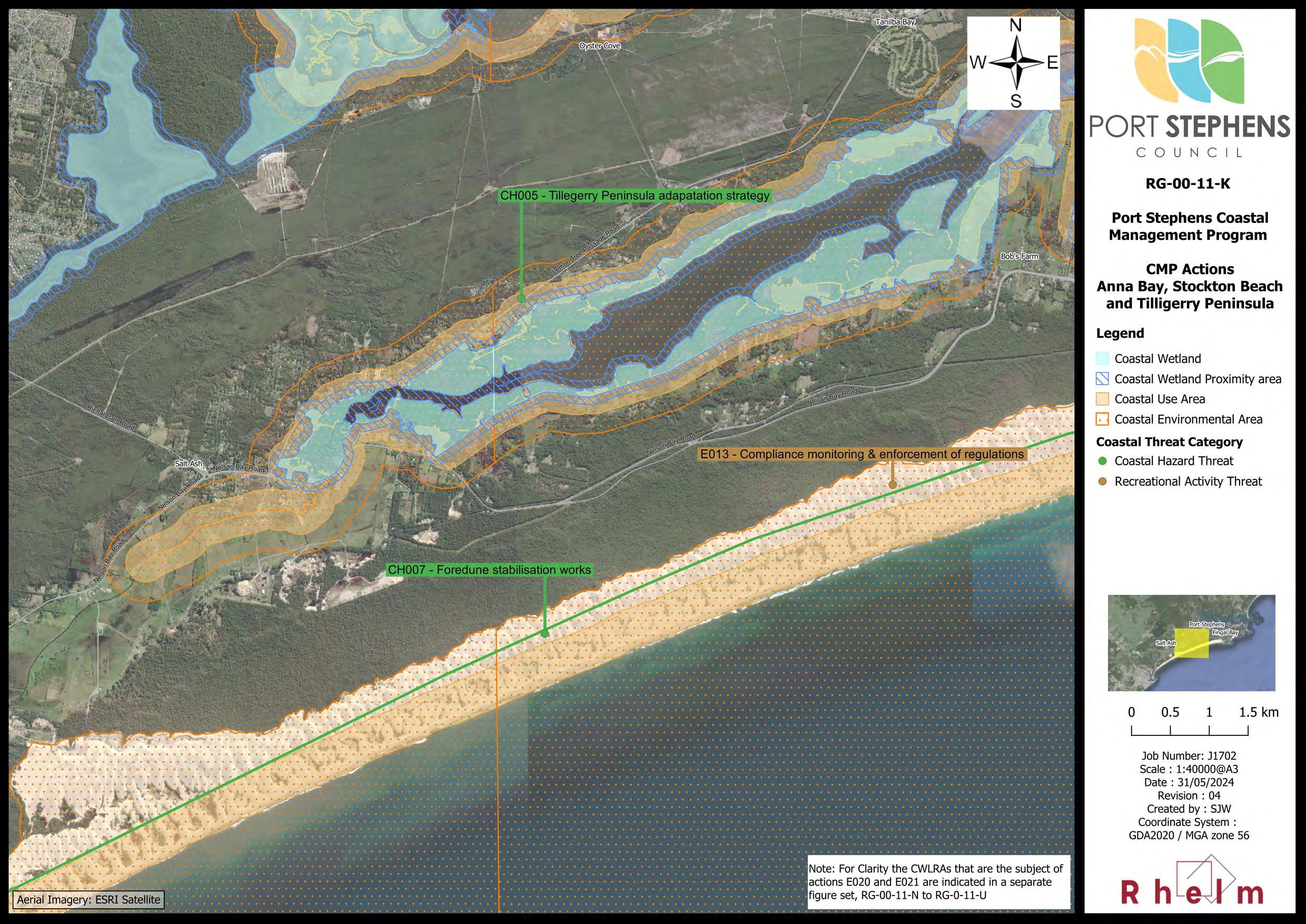
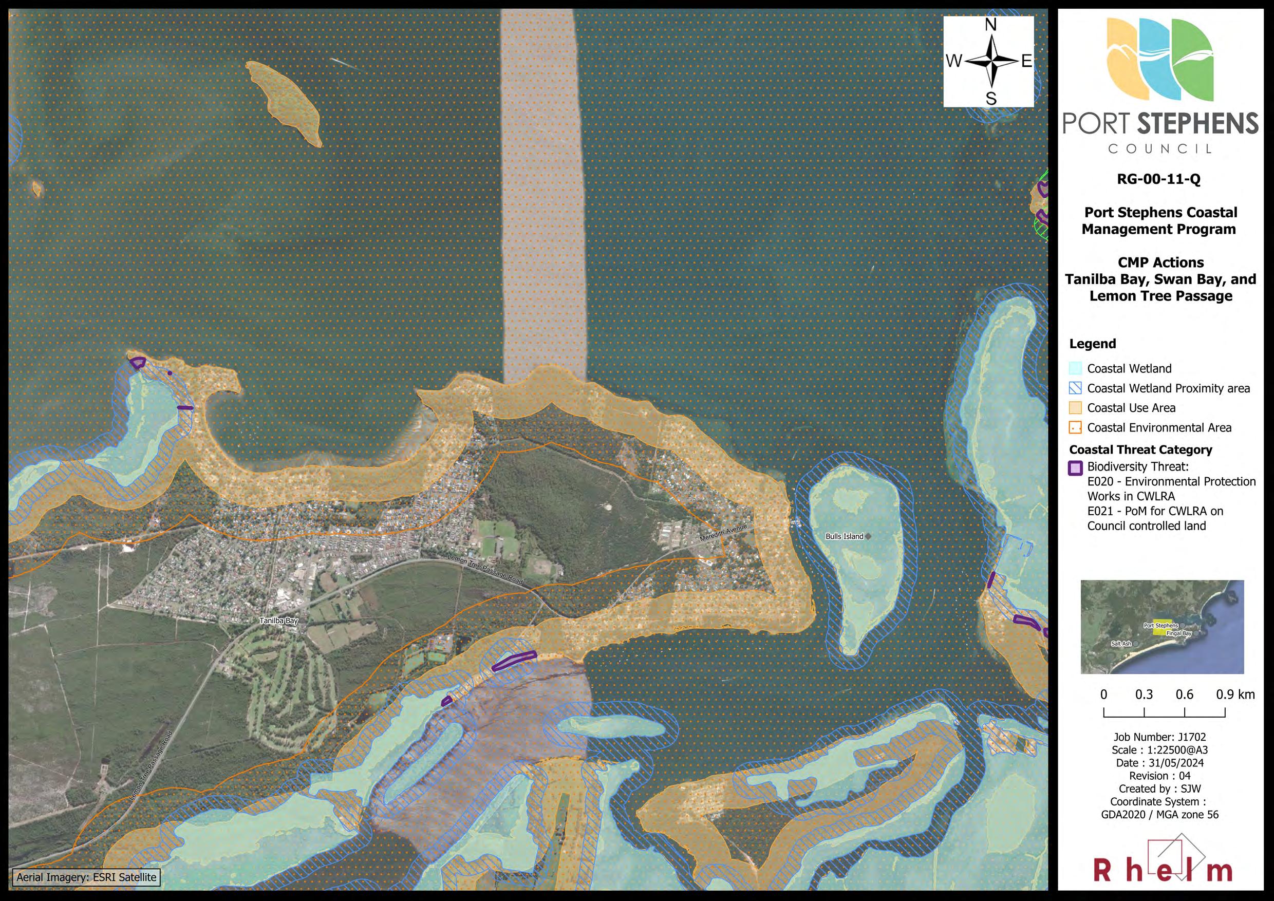
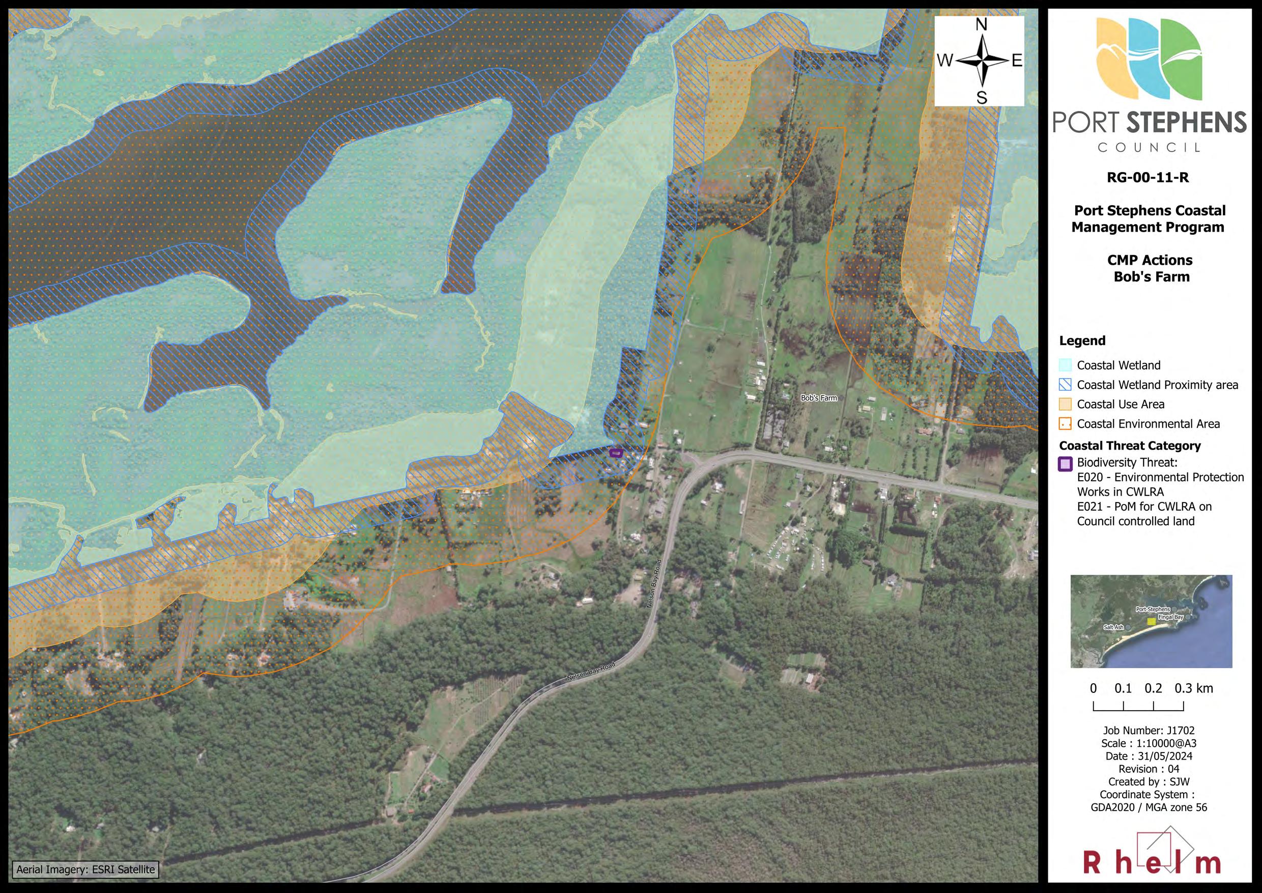
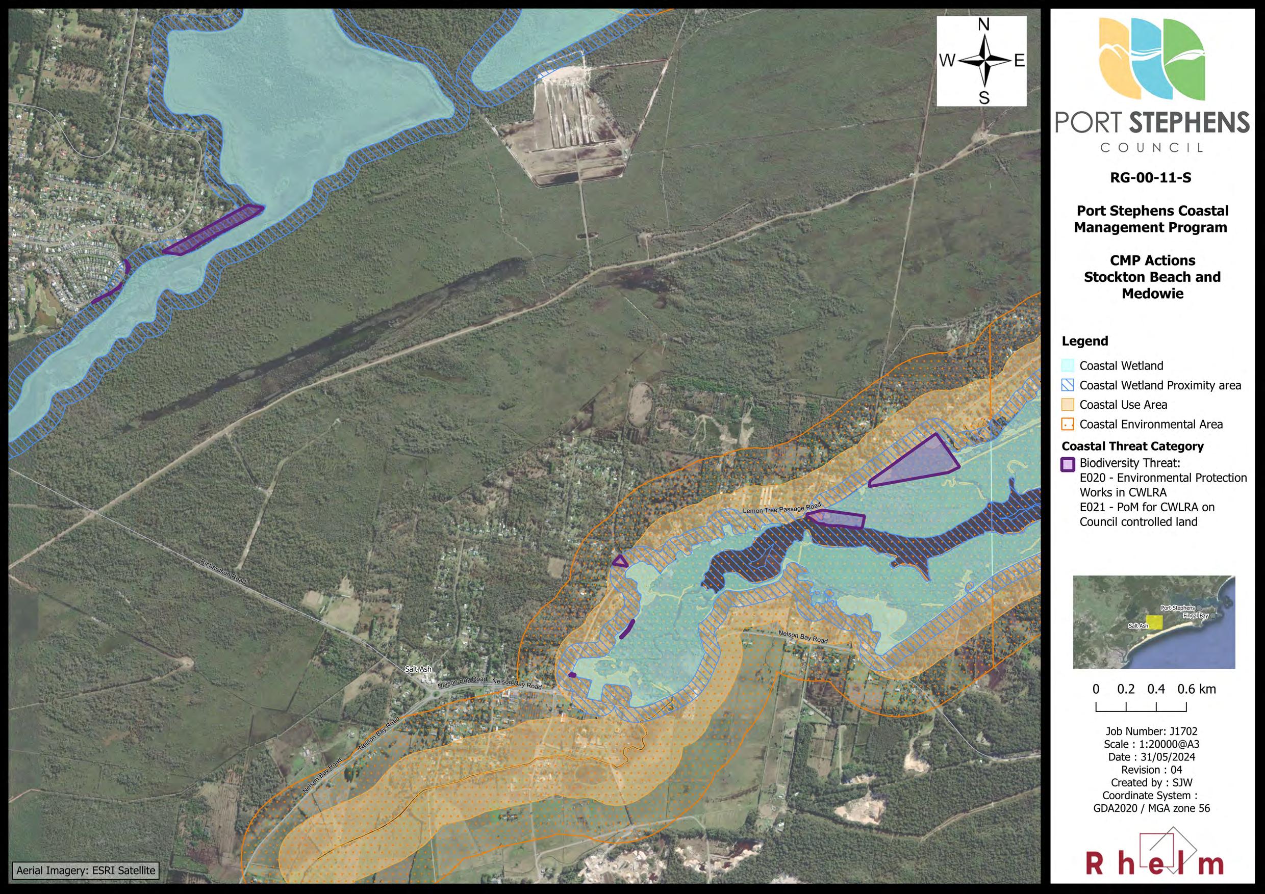
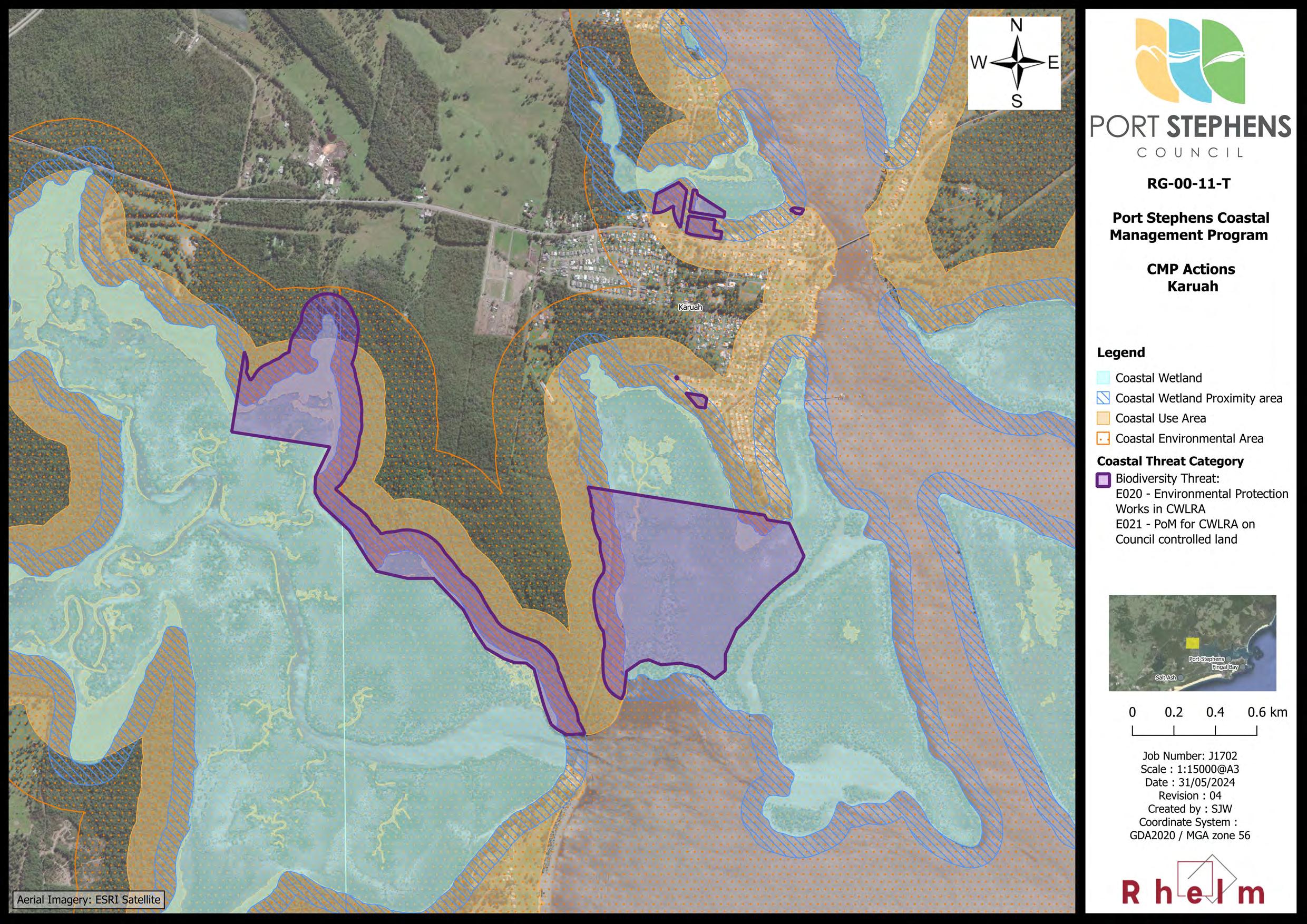
• Coastal Wetlands and Littoral Rainforest Area (CWLRA) – there are extensive areas of Coastal Wetlands around Tilligerry Creek, between Oyster Cove and Medowie, west and north of Swan Bay, and extending from Salamander Bay through Taylors Beach, Bobs Farm and to Anna Bay (Map RG00-02). There are small areas of Littoral Rainforest mapped at Nelson Head, Soldiers Point and Taylors Beach (Map RG-00-03).
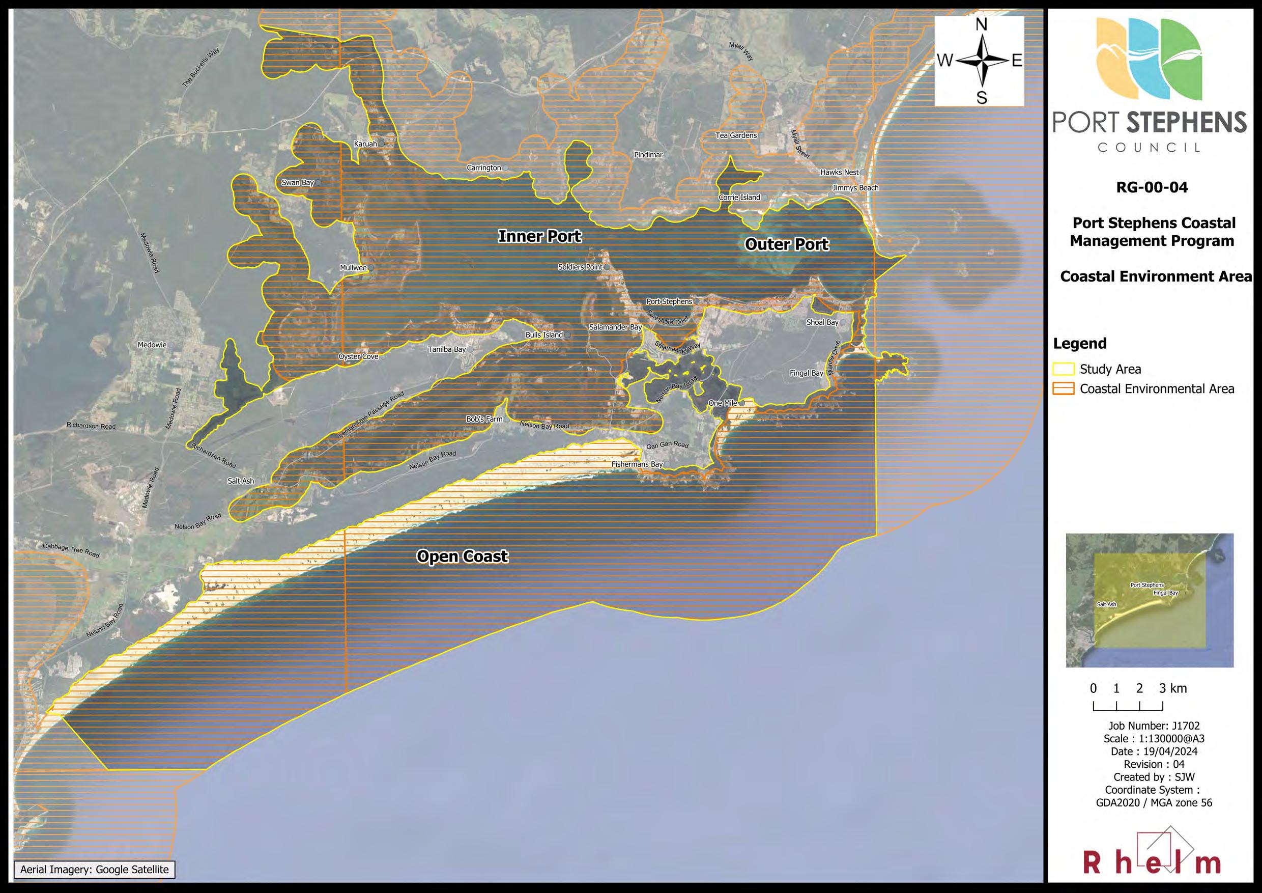
• Coastal Environment Area (CEA) – Comprises land containing coastal features such as the coastal waters of the State, estuaries, coastal lake, coastal lagoons and land adjoining these features, including headlands and rock platforms (OEH, 2018a). The extent of the CEA within the study area is mapped in Map RG-00-04
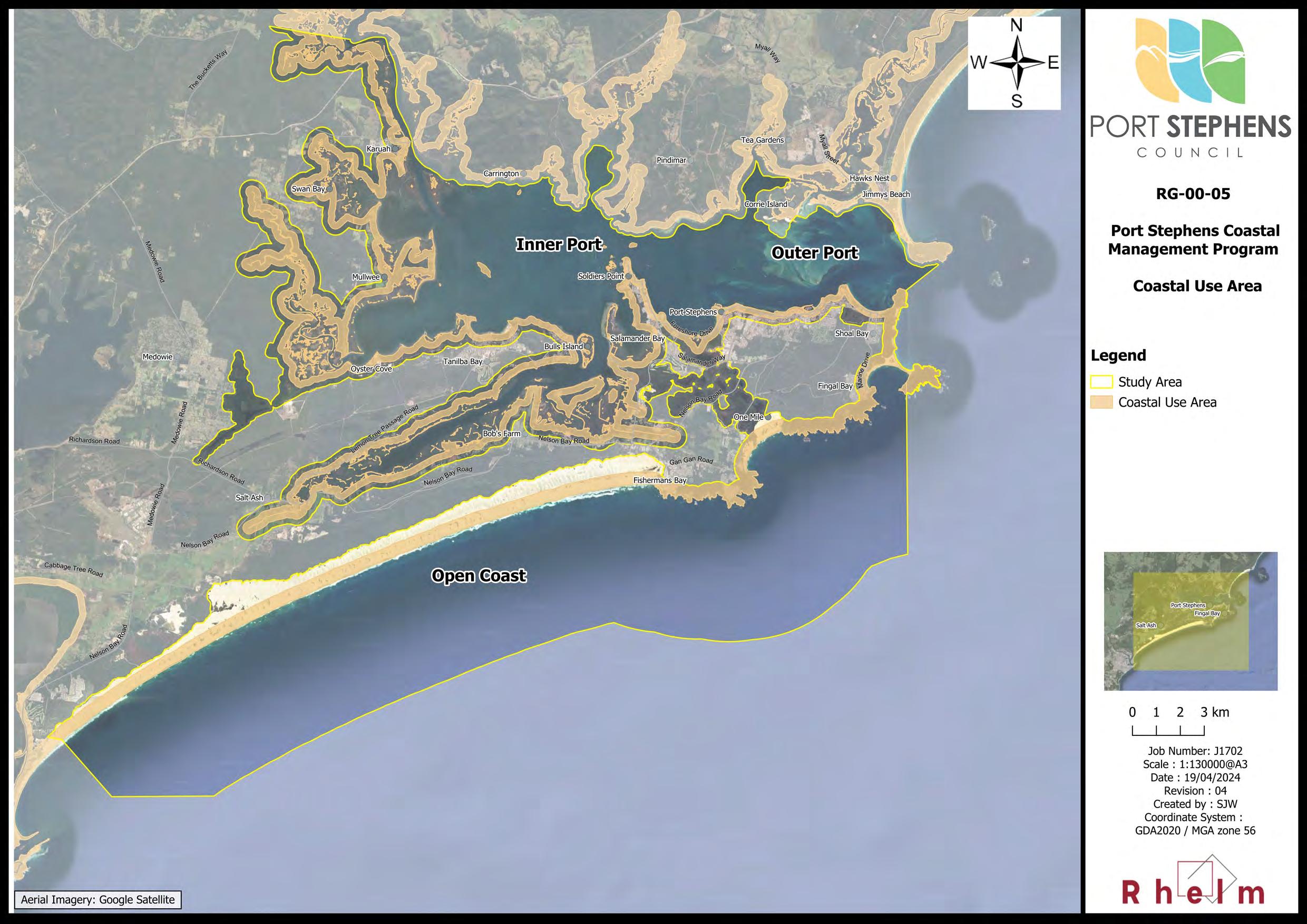
• Coastal Use Area (CUA) – The coastal use area includes land adjacent to coastal waters, estuaries, coastal lakes and lagoons where development is or may be carried out (now or in the future) (OEH, 2018a). There are a range of social and economic activities and development within the Port Stephens CUA, as mapped in Map RG-00-05
The abovementioned maps are provided in Appendix A.
Large parts of the study area are vulnerable to coastal hazards, as identified through the CMP Stage 2 report (BMT, 2021a). However, there is presently no mapping of a Coastal Vulnerability Area (CVA) under the Resilience and Hazards SEPP. The context for Council’s decision to prepare a planning proposal to map the CVA for the study area is provided in Section 4 and Section 8.4.
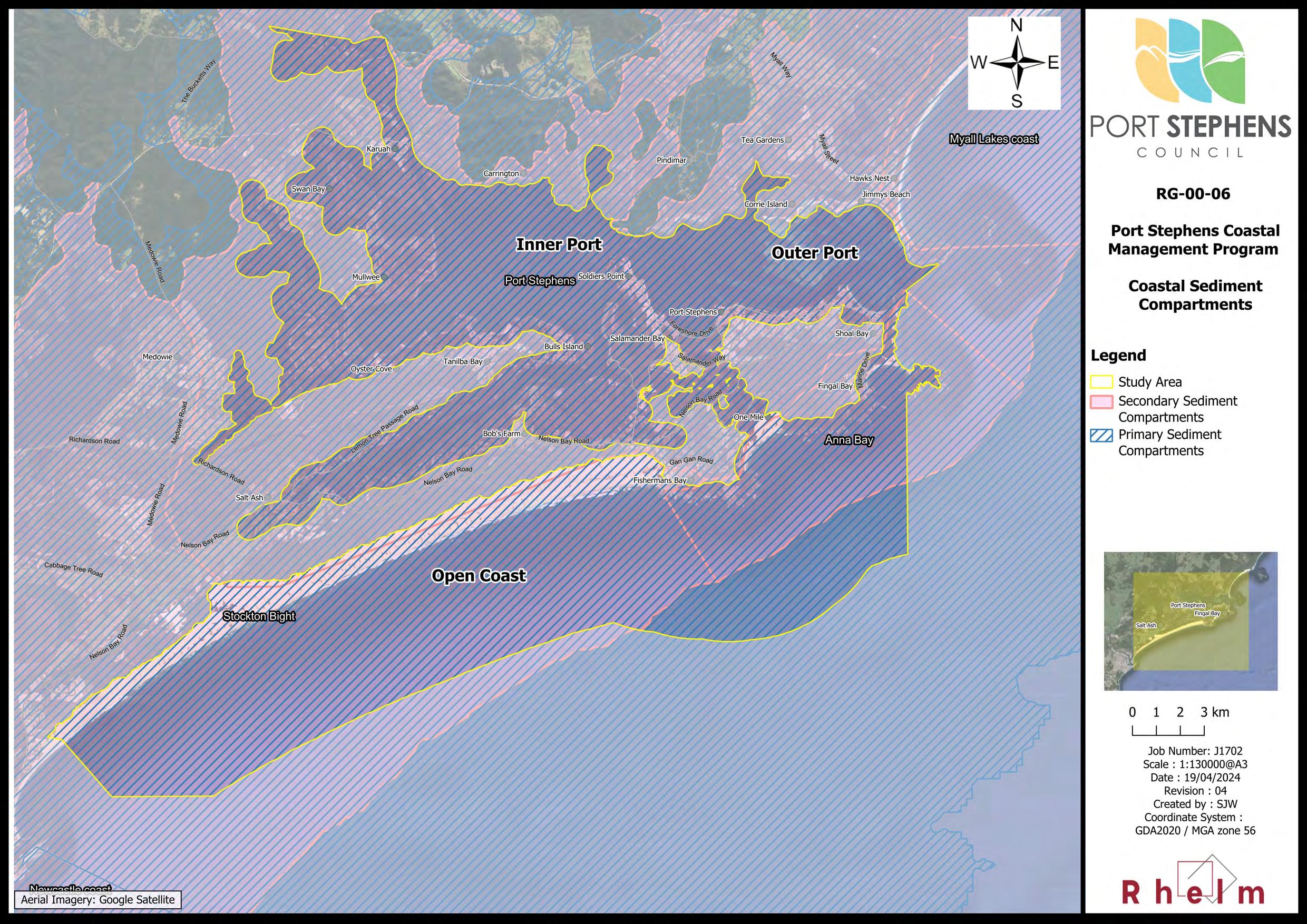
1.3.2 Coastal Sediment Compartments
The Port Stephens CMP study area is located within one primary sediment compartment, the Port Stephens compartment, which extends from Cape Hawke to Nobbys Head. Within this larger primary sediment compartment there are three secondary sediment compartments that extend across the study area (refer Map RG-00-06 in Appendix A):
• The Stockton Bight compartment which extends along the open coast from Birubi Point to the south and beyond the CMP study area;
• The Anna Bay compartment that extends along the open coast from Birubi Point north to Tomaree Point; and
• The Port Stephens compartment, which encompasses the Inner and Outer Port areas.
Port Stephens Coastal Management Program
The Port Stephens primary sediment compartment extends across parts of the MCC LGA to the north and the CN LGA to the south.
1.4 Vision, Objectives and Strategic Direction
The long-term strategic direction for the study area is encapsulated in a vision established for management of the Port Stephens coastal zone and is consistent with the objects of the Act and community values identified in the Stage 1 Scoping Study. The strategic vision statement for the Port Stephens CMP is as follows: Our community is resilient to environmental risks, coastal hazards and climate change Supporting the vision are a series of local coastal management objectives that have been developed to align with the objects of the CM Act. The management objectives for the Port Stephens CMP are summarised in Table 1-1
Table 1-1 Port Stephens Coastal Management Objectives
Collaboration
Biodiversity & ecosystem integrity
Encourage collaboration and partnership with government, agencies and our community to manage and protect the coastal zone.
Protect biological diversity and ecosystem integrity by maintaining and improving water quality and estuary health.
Climate change Mitigate and build resilience to current and future coastal hazards and risks.
Land use planning
Aboriginal custodianship
Coastal economies
Facilitate ecologically sustainable development in the coastal zone and prioritise sustainable land use planning in decision making to maintain and improve public access, amenity and use.
Support and protect our Aboriginal community’s spiritual, social, customary and economic use of the coastal zone.
Support sustainable economic opportunities within the coastal zone.
The CM Act requires that, in preparing a CMP, a local Council must:
• Consider and promote the objects of the CM Act; and
• Give effect to the management objectives for CMAs covered by the Program.
These requirements are addressed in Table 1-2 and Table 1-3, respectively. It is noted that, although there is no mapped CVA for the Port Stephens coastal zone, the objects for Coastal Vulnerability Areas have still been discussed in the context of the Port Stephens CMP.
Table 1-2 Alignment with the Objects of the CM Act
Objects of the Act
How this is addressed in this CMP
3 The objects of this Act are to manage the coastal environment of New South Wales in a manner consistent with the principles of ecologically sustainable development for the social, cultural and economic well-being of the people of the State, and in particular—
(a) To protect and enhance natural coastal processes and coastal environmental values including natural character, scenic value, biological diversity and ecosystem integrity and resilience, and
This object is reflected in the ‘Biodiversity & ecosystem integrity’, ‘Climate change’ and ‘Land use planning’ management objectives for the CMP (refer Table 1-1).
Consideration of these values and relevant threats have been detailed in Sections 2.1 and 2.2, and a number of management actions developed accordingly (refer Section 3). There are seven actions targeting threats to biodiversity and ecosystems included in the CMP.
Objects of the Act
(b) To support the social and cultural values of the coastal zone and maintain public access, amenity, use and safety, and
How this is addressed in this CMP
This object is reflected in the ‘Climate change’ and ‘Land use planning’ management objectives for the CMP (refer Table 1-1).
Consideration of these values and relevant threats have been detailed in Sections 2.1 and 2.2, respectively, and a number of management actions developed accordingly (refer Section 3). This includes several activities to provide for public access and safety, as well as a Coastal Zone Emergency Subplan (CZEAS; refer Appendix C).
(c) To acknowledge Aboriginal peoples’ spiritual, social, customary and economic use of the coastal zone, and
(d) To recognise the coastal zone as a vital economic zone and to support sustainable coastal economies, and
This object is reflected in the ‘Aboriginal custodianship’ management objective for the CMP (refer Table 1-1). Engagement was undertaken with Traditional Owners during preparation of this CMP, as detailed in Section 1.5 and Appendix B
Several management actions are included in the CMP to address identified threats and support Aboriginal cultural heritage values and practices (refer Section 3).
This object is reflected in the ‘Coastal economies’ management objectives for the CMP (refer Table 1-1).
Consideration of these values and relevant threats have been detailed in Sections 2.1 and 2.2, respectively, and a number of management actions developed accordingly (refer Section 3).
This object is reflected in the ‘Land use planning’ management objective for the CMP (refer Table 1-1).
A review of the current planning controls was undertaken in Stage 3 (refer Rhelm and Bluecoast, 2023) and provided recommendations to Council on potential pathways to provide appropriate management of risk to development from coastal hazards.
(e) To facilitate ecologically sustainable development in the coastal zone and promote sustainable land use planning decision-making, and
(f) To mitigate current and future risks from coastal hazards, taking into account the effects of climate change, and
A number of relevant management actions were developed as a result of this review and other engagement activities (refer Section 3).
Council has determined to proceed with a planning proposal for a CVA, and will also prepare a planning proposal for a local coastal risk planning clause and map in their Local Environmental Plan (LEP), with associated controls through the Development Control Plan (DCP).
The discussion provided in Section 4 and in the review of existing planning instruments and development controls provided in Appendix B of the Stage 3 Report (Rhelm and Bluecoast, 2023) provides context for this decision.
This object is reflected in the ‘Climate change’ management objective for the CMP (refer Table 1-1).
Current and future risk from coastal hazards was assessed in Stage 2 (BMT, 2021b). A total 25 of management actions have been included in the CMP to directly address the threat from coastal hazards under current and future sea levels, including planning controls (see above), works, adaptation planning, monitoring, and education and awareness raising activities (refer Section 3).
Objects of the Act
(g) To recognise that the local and regional scale effects of coastal processes, and the inherently ambulatory and dynamic nature of the shoreline, may result in the loss of coastal land to the sea (including estuaries and other arms of the sea), and to manage coastal use and development accordingly, and
(h) To promote integrated and coordinated coastal planning, management and reporting, and
How this is addressed in this CMP
Local and regional coastal processes were described in the Stage 2 study undertaken by BMT WBM (2021a). A range of management actions have been included in this CMP to ensure improved recognition of coastal processes and provide for improved resilience in this regard, including recommendations for planning controls, monitoring and community education (refer Section 3).
This object is reflected in the ‘Collaboration’ management objective for the CMP (refer Table 1-1). Reference is also made to Section 1.5 and Appendix B
Several management actions have been included in this CMP to facilitate coordination (refer Section 3), and where other agencies are partnering or leading implementation of actions, this is identified in the Business Plan (Section 5).
(i) To encourage and promote plans and strategies to improve the resilience of coastal assets to the impacts of an uncertain climate future including impacts of extreme storm events, and
(j) To ensure co-ordination of the policies and activities of government and public authorities relating to the coastal zone and to facilitate the proper integration of their management activities, and
(k) To support public participation in coastal management and planning and greater public awareness, education and understanding of coastal processes and management actions, and
(l) To facilitate the identification of land in the coastal zone for acquisition by public or local authorities in order to promote the protection, enhancement, maintenance and restoration of the environment of the coastal zone, and
This object is reflected in the ‘Climate Change’ and ‘Land use planning’ management objectives for the CMP (refer Table 1-1).
Risks to coastal assets are to be addressed through a number of management actions included in this CMP (refer Section 3), including land use and planning controls, preparation of adaptation strategies to address long-term risk, and emergency management measures in the CZEAS.
This object is realised through preparation of this CMP, with stakeholder engagement activities documented in Section 1.5 and Appendix B. Letters of support from agencies have been provided along with the Final CMP
Community engagement activities undertaken in development of this CMP are documented in Section 1.5 and Appendix B. In addition, there are a number of management actions in this CMP that aim to provide for ongoing community participation and improved public awareness (refer Section 3).
No land acquisition has been proposed as part of this CMP; however, a range of activities on public land are proposed to provide for protection, enhancement, maintenance and restoration of the coastal environment (refer Section 3).
Objects of the Act
(m) To support the objects of the Marine Estate Management Act 2014.
How this is addressed in this CMP
Refer to stakeholder engagement undertaken for this CMP as summarised in Section 1.5. In addition, management actions have been developed that address threats to the Port Stephens coastal zone that align with several of those identified in the NSW Marine Estate Threat and Risk Assessment for the Marine Estate (BMT WBM, 2017); for example, the impact of marine debris on aquatic fauna (WQ Threat 5, see Section 2.2).
Objects for CMAs How this is addressed in this CMP
6(2) The management objectives for the coastal wetlands and littoral rainforests area are as follows
(a) to protect coastal wetlands and littoral rainforests in their natural state, including their biological diversity and ecosystem integrity,
(b) to promote the rehabilitation and restoration of degraded coastal wetlands and littoral rainforests,
(c) to improve the resilience of coastal wetlands and littoral rainforests to the impacts of climate change, including opportunities for migration,
(d) to support the social and cultural values of coastal wetlands and littoral rainforests,
(e) to promote the objectives of State policies and programs for wetlands or littoral rainforest management.
Threats to CWLRAs in the study area are identified in Table 2-3. Related threats identified in the risk assessment (refer Section 2.3) include: CH Threat 5, WQ Threats 1 to 4, BD Threats 1 and 2, LC Threat 1 and RA Threat 2.
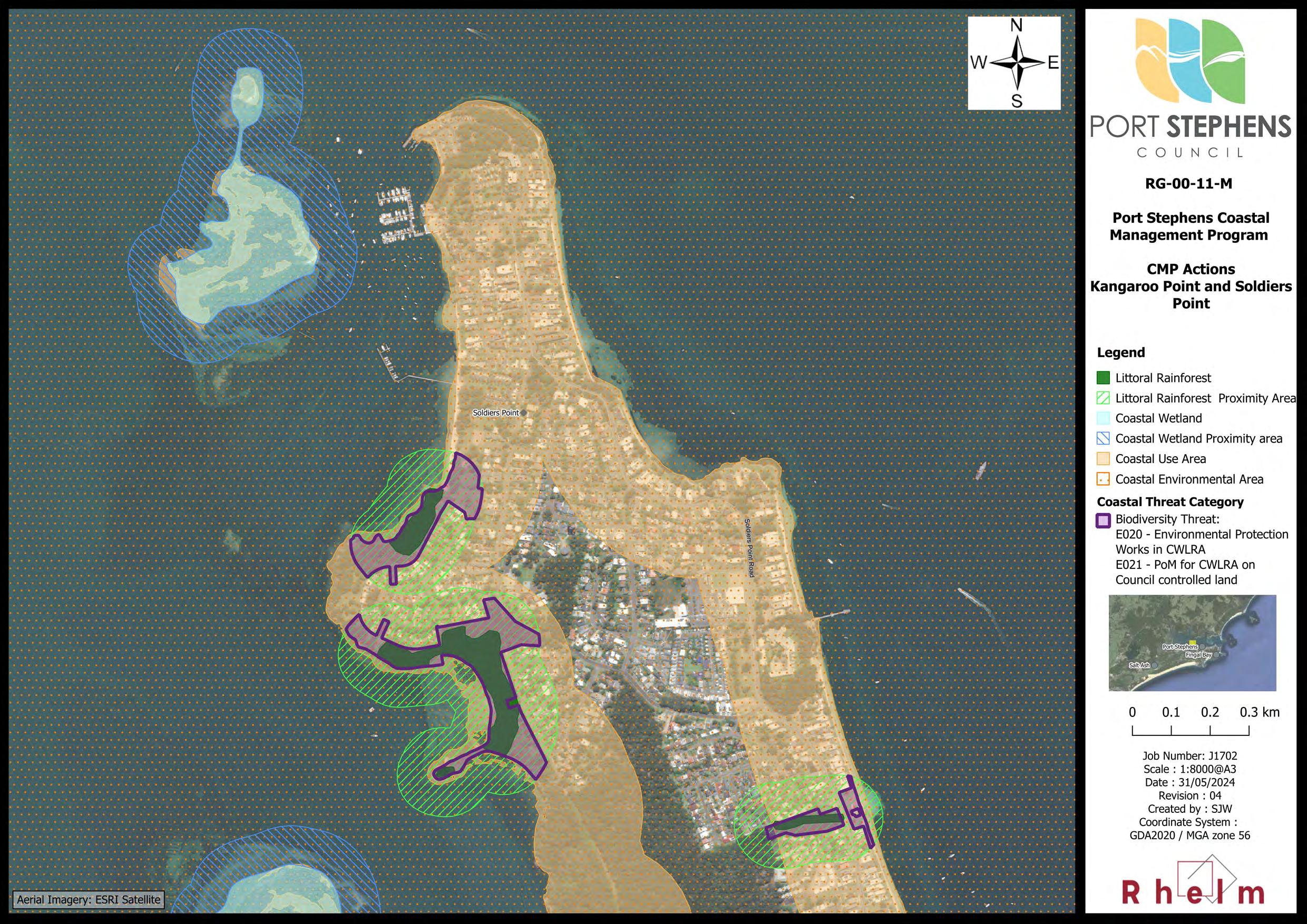
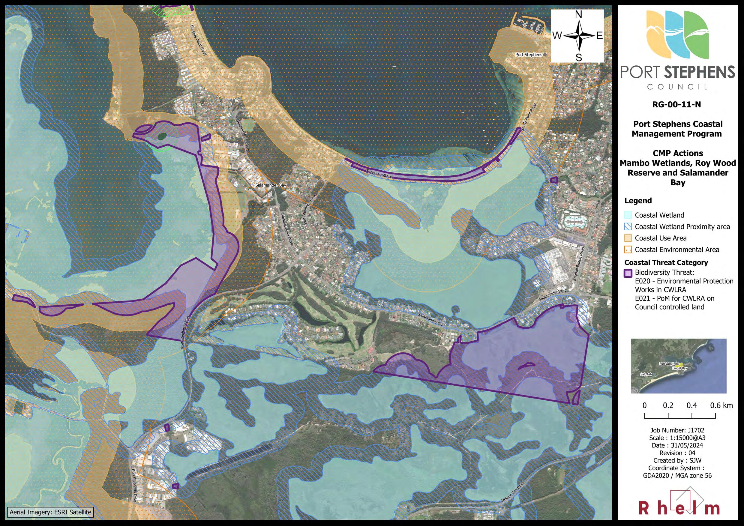
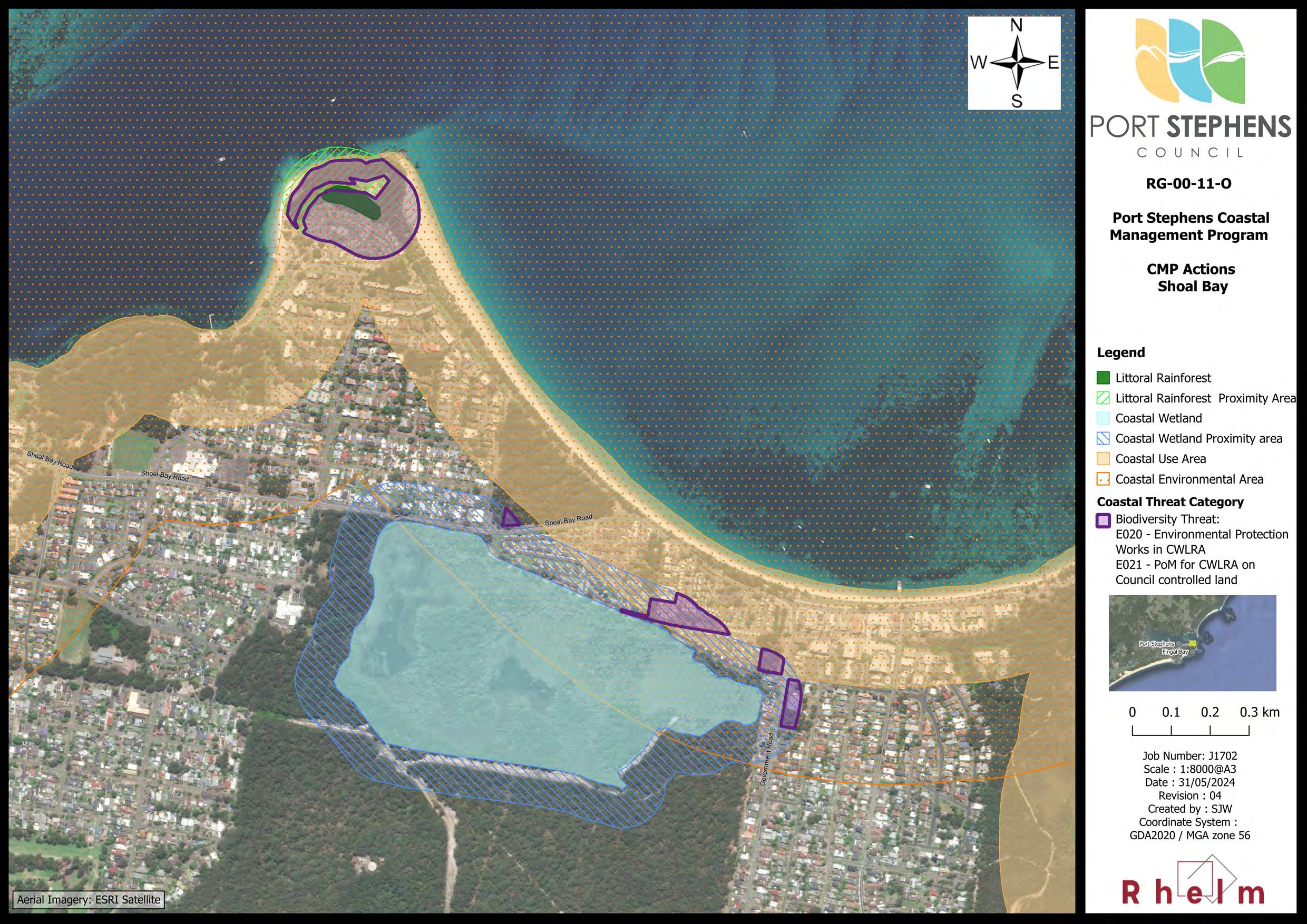
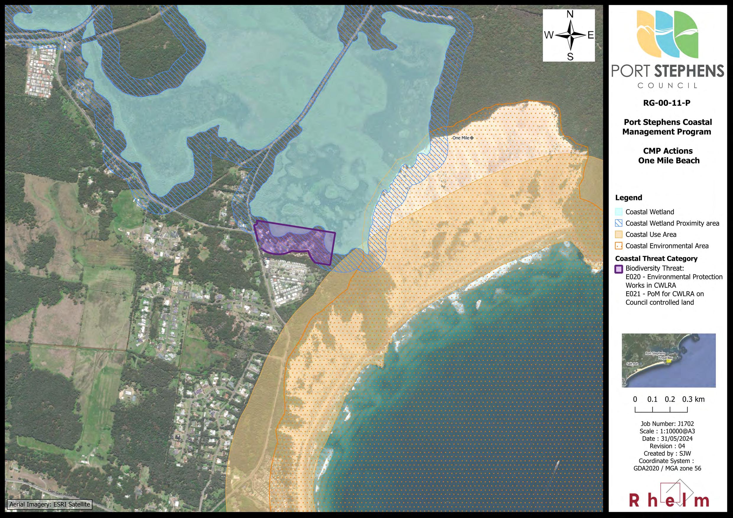
A range of management options were considered in Stage 3 to address these threats, and several have been adopted as management actions in this CMP (see Section 3), including: CH029, E001, E004, E005, E008 and E018. Additional management actions of relevance to CWLRAs include E020 and E021. These management actions are considered consistent with the State policies and programs for wetlands and littoral rainforest management.
7(2) The management objectives for the coastal vulnerability area are as follows
(b) to mitigate current and future risk from coastal hazards by taking into account the effects of coastal processes and climate change,
(a) to ensure public safety and prevent risks to human life, Council has decided to proceed with mapping of a CVA for the study area using the mapping of the land that is vulnerable to coastal hazards prepared for Stage 2 (refer BMT, 2021a), which is discussed in Section 2.2.2
(c) to maintain the presence of beaches, dunes and the natural features of foreshores, taking into account the beach system operating at the relevant place,
(d) to maintain public access, amenity and use of beaches and foreshores,
(e) to encourage land use that reduces exposure to risks from coastal hazards, including through siting, design, construction and operational decisions,
(f) to adopt coastal management strategies that reduce exposure to coastal hazards
The risk to both land and built and natural assets from coastal hazards is discussed in Table 2-3 and Section 2.3 and include: all CH Threats 3 and RA Threat 2. A range of management options were considered in Stage 3 to address these threats, and several have been adopted as management actions in this CMP (see Section 3), in particular all actions with a unique identifier starting with CH. In addition, a number of actions to maintain beaches and dunes, and to maintain
3 Note: CH Threat 3, which relates to impacts arising from sand drift is not defined as a ‘coastal hazard’ under the CM Act, and would therefore not form part of a CVA.
Table 1-3 Alignment with the Management Objectives for CMAs under the Resilience and Hazards SEPP
Objects for CMAs
(i) in the first instance and wherever possible, by restoring or enhancing natural defences including coastal dunes, vegetation and wetlands, and (ii) if that is not sufficient, by taking other action to reduce exposure to those coastal hazards,
(g) if taking that other action to reduce exposure to coastal hazards—
(i) to avoid significant degradation of biological diversity and ecosystem integrity, and (ii) to avoid significant degradation of or disruption to ecological, biophysical, geological and geomorphological coastal processes, and (iii) to avoid significant degradation of or disruption to beach and foreshore amenity and social and cultural values, and (iv) to avoid adverse impacts on adjoining land, resources or assets, and
(v) to provide for the restoration of a beach, or land adjacent to the beach, if any increased erosion of the beach or adjacent land is caused by actions to reduce exposure to coastal hazards,
(h) to prioritise actions that support the continued functionality of essential infrastructure during and immediately after a coastal hazard emergency,
(i) to improve the resilience of coastal development and communities by improving adaptive capacity and reducing reliance on emergency responses.
How this is addressed in this CMP
public access and amenity, are proposed under management actions with a unique identifier starting with RA or E.
8(2) The management objectives for the coastal environment area are as follows
(b) to reduce threats to and improve the resilience of coastal waters, estuaries, coastal lakes and coastal lagoons, including in response to climate change,
(c) to maintain and improve water quality and estuary health,
(a) to protect and enhance the coastal environmental values and natural processes of coastal waters, estuaries, coastal lakes and coastal lagoons, and enhance natural character, scenic value, biological diversity and ecosystem integrity, Threats to the Port Stephens CEA are identified in Table 2-3. Related threats identified in the risk assessment (refer Section 2.3) include: CH Threat 3, all WQ Threats, BD Threats 1 and 2, LC Threat 1, ME Threat 1, and RA Threats 1 and 2.
(d) to support the social and cultural values of coastal waters, estuaries, coastal lakes and coastal lagoons,
(e) to maintain the presence of beaches, dunes and the natural features of foreshores, taking into account the beach system operating at the relevant place,
(f) to maintain and, where practicable, improve public access, amenity and use of beaches, foreshores, headlands and rock platforms.
A range of management options were considered in Stage 3 to address these threats, and several have been adopted as management actions in this CMP (see Section 3), including: all actions with a unique identifier starting with WQ and other actions such as: RA001, RA002, CH074, and CH003.
9(2) The management objectives for the coastal use area are as follows
1. to protect and enhance the scenic, social and cultural values of the coast by ensuring that
Threats to the Port Stephens CUA are identified in Table 2-3. Related threats
Objects for CMAs
(i) the type, bulk, scale and size of development is appropriate for the location and natural scenic quality of the coast, and (ii) adverse impacts of development on cultural and built environment heritage are avoided or mitigated, and (iii) urban design, including water sensitive urban design, is supported and incorporated into development activities, and (iv) adequate public open space is provided, including for recreational activities and associated infrastructure, and (v) the use of the surf zone is considered,
2. to accommodate both urbanised and natural stretches of coastline.
1.5 Key Stakeholders, Their Interests and Issues
How this is addressed in this CMP
identified in the risk assessment (refer Section 2.3) include: all CH Threats, LC Threat 1, ME Threat 1, and RA Threats 1 and 2.
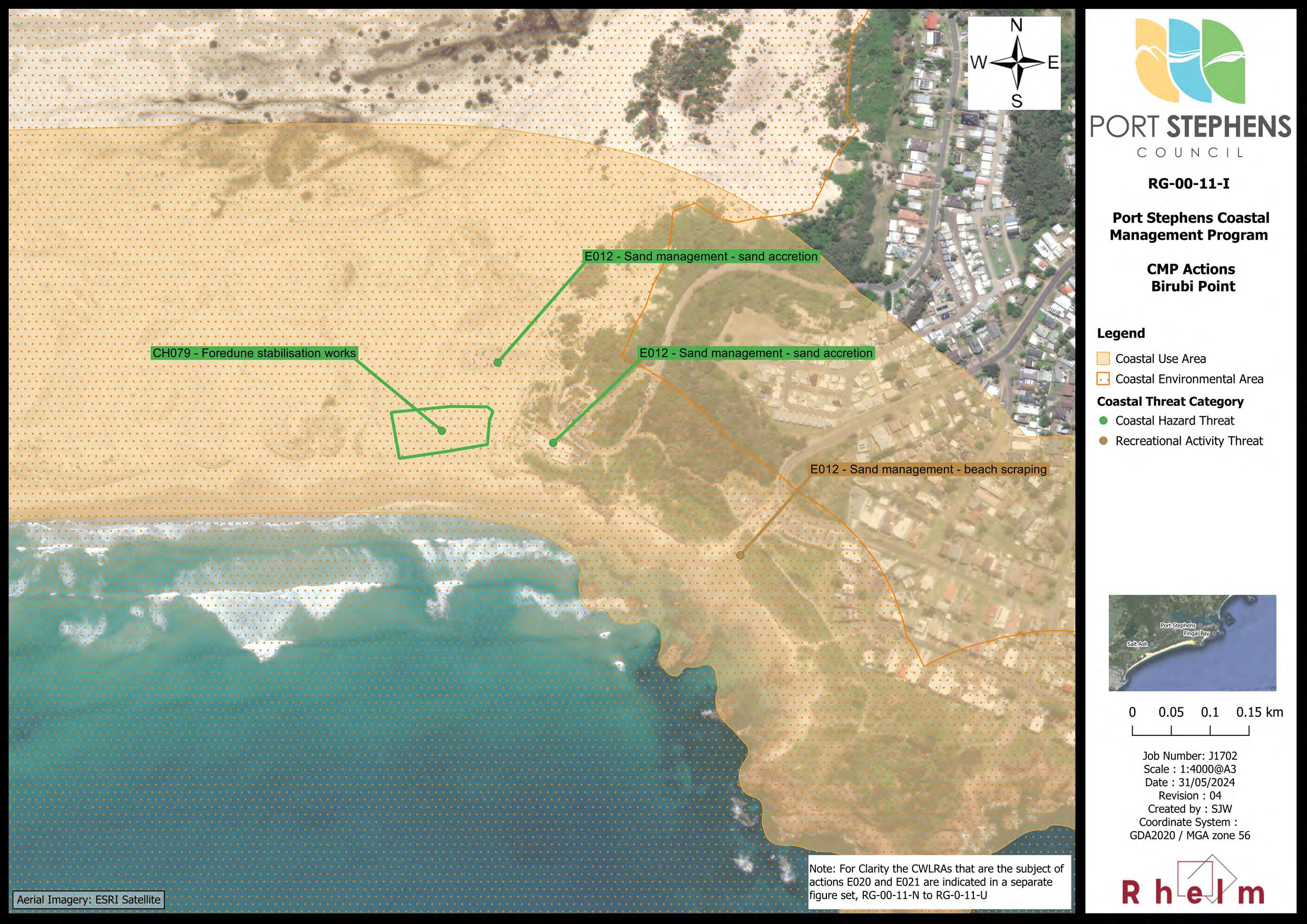
A range of management options were considered in Stage 3 to address these threats, and several have been adopted as management actions in this CMP (see Section 3), such as: CH074, CH082, DI001, E012, E016, and E017.
Key stakeholders including Federal and State Government Agencies, other local organisations and Traditional Owners are in some way involved in governance of the Port Stephens coastal zone (or aspects thereof) due to a regulatory or customary role in coastal management. The CMP study area comprises a mix of tenures and regulatory or statutory jurisdictions. Relevant land tenures include:
• One of the biggest tenures is Crown land, including dedicated or reserved Crown land and unreserved Crown land, with the latter including all land below the MHWM;
• National Park estate lands are also a major land tenure, comprising National Parks, Nature Reserves and State Conservation Areas gazetted under the NP&W Act and under care and control of the NPWS (in conjunction with the Worimi Conservation Lands Board for the Worimi Conservation Lands);
• Land held under Native Title under the Commonwealth Native Title Act 1993 or subject to a successful Aboriginal Land Claim under the NSW Aboriginal Land Rights Act 1984. In addition, there are a number of pending claims associated with the study area Any management actions proposed on Crown land will need to consider the potential for existing or future claims made under either Act;
• Land owned by the Worimi Local Aboriginal Land Council (LALC);
• Council-owned lands, including Operational and Community Land managed under the Local Government Act 1993 (LG Act);
• The Port Stephens – Great Lakes Marine Park, which is managed by the Department of Primary Industries (DPI) – Marine Parks. The majority of the CMP study area falls within the Marine Park, with the exception of the area south of Birubi Point; and
• Land owned by various utilities and other agencies, including Transport for NSW (TfNSW), Hunter Water Corporation (HWC), Ausgrid and the Commonwealth Department of Defence.
Various agencies also have a regulatory role with jurisdictions intersecting the coastal zone including DPHI – Crown Lands and Public Spaces, DPHI – Planning, NPWS, DPI – Marine Parks and DPI – Fisheries and TfNSW The need for landowner consent, or to obtain any required approvals, permits or licences, would be addressed in consultation with the relevant organisations at the time of implementation of individual management actions.
A Community and Stakeholder Engagement Plan and Summary Report (PSC and Rhelm, 2023) was prepared for this CMP and is provided in Appendix B. That document sets out the strategy that was adopted to engage with the community and key stakeholders, as required by the CM Act and CM Manual. The engagement activities undertaken in preparing this CMP are summarised in Table 1-4
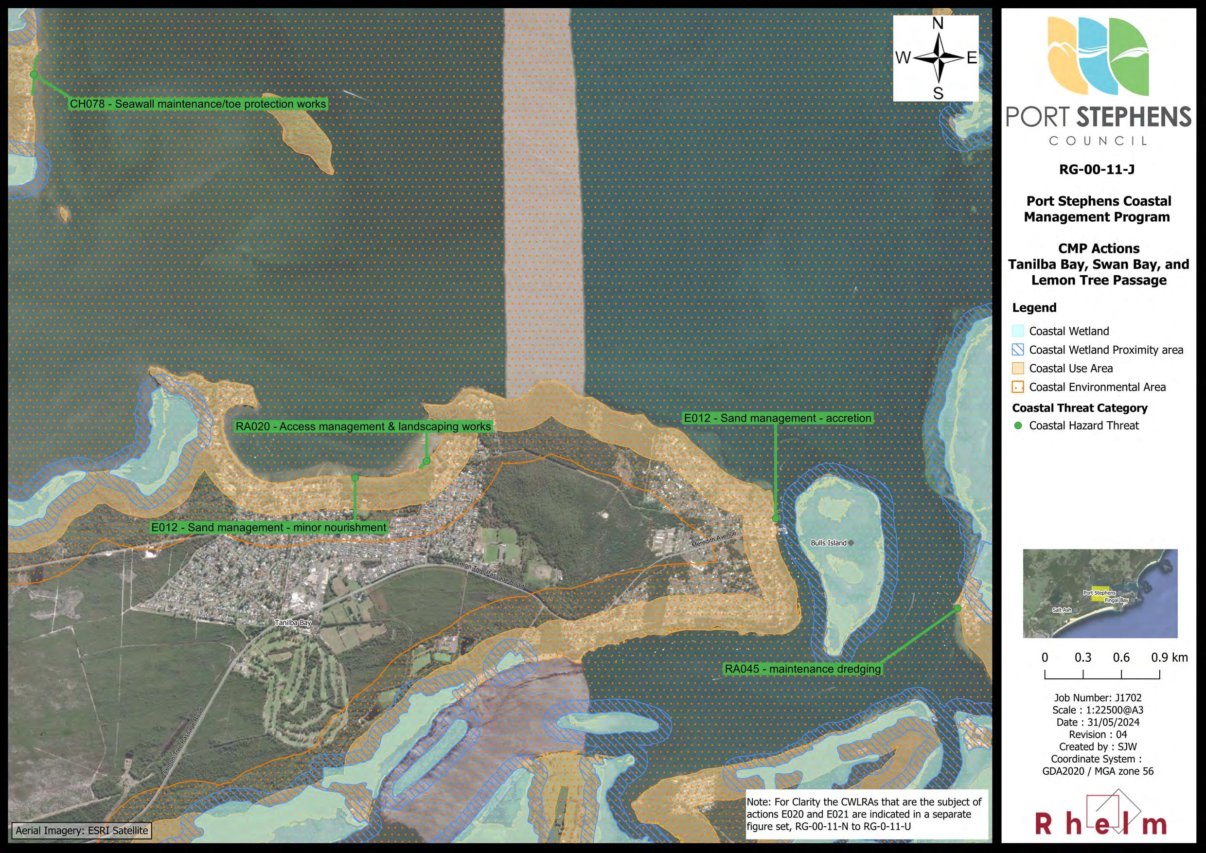
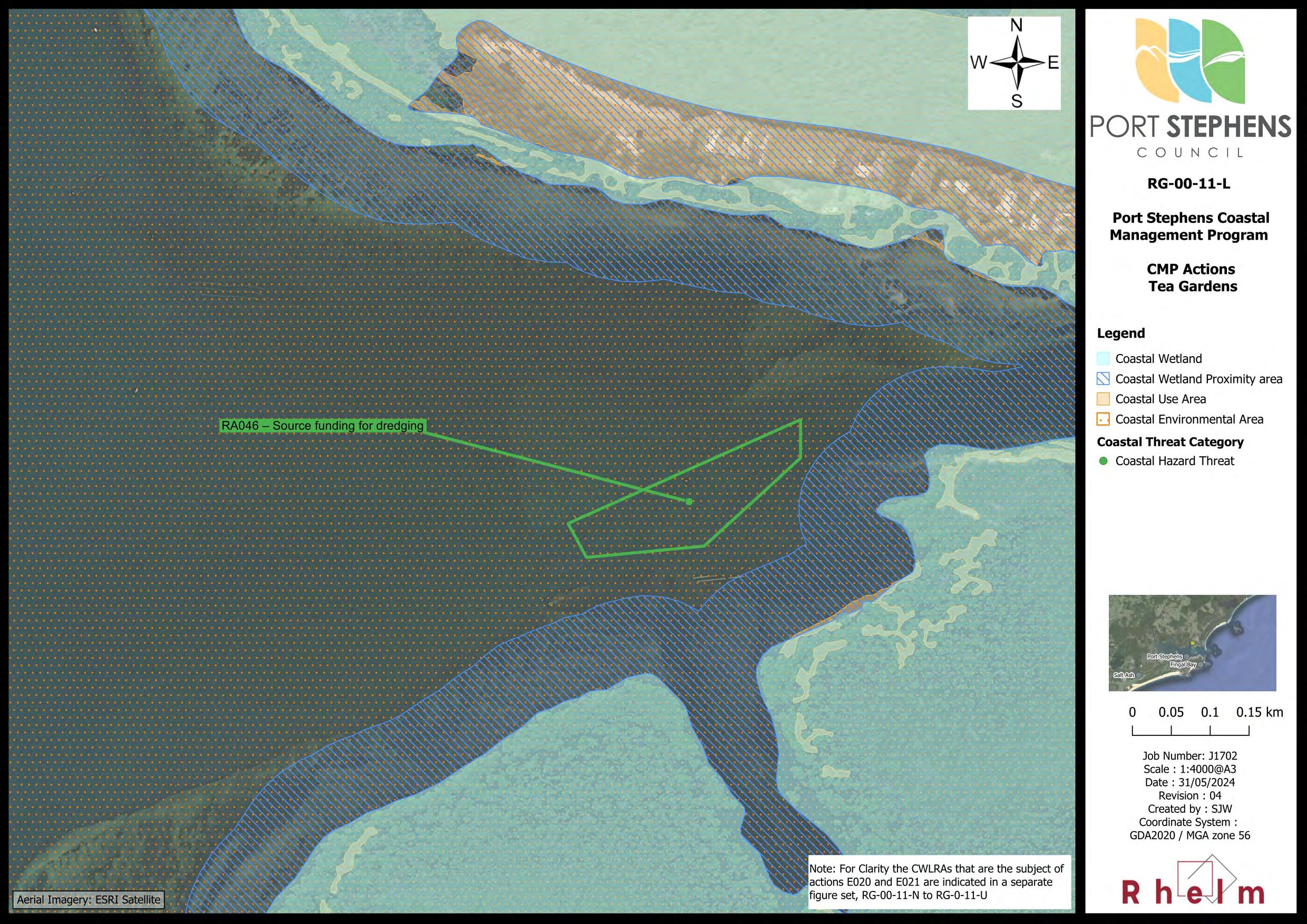
During preparation of this CMP PSC has engaged with CN and MCC, being the two neighbouring Councils to the south and north of the Port Stephens LGA respectively, as documented in Appendix B and Table 1-4 Along with Port Stephens LGA, these two LGAs intersect the Port Stephens sediment compartment, with Council and CN sharing the Stockton Bight secondary sediment compartment, and PSC and MCC sharing the Port Stephens secondary sediment compartment. The only management actions in this CMP that specifically targets crossboundary coordination are Action WQ002 (‘Enter into a data sharing agreement to enable sharing of historical and ongoing water quality monitoring data from Port Stephens’) and Action RA046 (‘Advocate for a State Government commitment to funding the delivery of ongoing, long-term maintenance and navigational dredging of Corrie Channel’).
Public authorities and other organisations which will be affected by implementation of the CMP have been consulted regarding the coastal zone management issues and actions in this CMP, as documented in Appendix B and Table 1-4.
Table 1-4 Summary of Engagement Activities Undertaken During Each Stage of the CMP
• Provision of information on the CMP and updates on progress via Council’s dedicated project webpage, including fact sheets and a Have Your Say webpage;
Stage 1
• Meetings of the PSC CMP Steering Group on a monthly basis;
• Meetings with a range of key agency stakeholders; and
• Surveys of community values.
• Provision of information on the CMP and updates on progress via Council’s dedicated project webpage, including fact sheets, online mapping tool, and a Have Your Say webpage;
• Meetings of the PSC CMP Steering Group on a monthly basis;
• Presentations to Councillors;
• Engagement with Traditional Owners via Council’s Aboriginal Strategic Committee,
Stage 2
• A webinar series on coastal hazards, which were then uploaded to the project webpage;
• Youth Week ‘Pizza for the planet’ event;
• Meetings with the Tomaree Ratepayers and Residents Association and EcoNetwork Port Stephens community groups; and
• Water quality workshops with the Stakeholder Reference Group (comprising members noted in Table 1-5).
• Meetings of the PSC CMP Steering Group on a monthly basis;
• Initial engagement with Traditional Owners via members of the boards of the Worimi LALC and WCLB. In addition, a presentation was made to the Birubi Point Cultural Heritage Advisory Committee;
• Workshops with PSC staff on:
- Council assets subject to risk from coastal hazards,
Stage 3
- Land use planning and development controls for management of risk from coastal hazards,
- Potential management options for the CMP;
• Workshops with the Stakeholder Reference Group comprised of the range of agency and other stakeholders involved in different aspects of management of the study area. These workshops included an initial presentation on coastal hazards and a management options workshop;
• Four face-to -face community drop-in sessions over 3-4 May 2023 on the coastal hazard mapping;
CMP Stage Engagement Activities
• Council staff also held on-site meetings with directly affected landholders in key locations;
• One virtual and two face-to-face workshops with community members over 7-8 June 2023 to discuss potential management options;
• Opportunity for community members to identify management issues and suggest management options via an online Social Pinpoint map made available on Council’s webpage; and
• Separate meetings between PSC and MCC and CN on interfaces between the Port Stephens CMP and adjacent CMPs, primarily with respect to consistency of the respective CMPs, coastal hazard studies and mapping for the adjacent study areas, responsibility for any management initiatives currently undertaken (or proposed) that may overlap CMP boundaries
• An additional meeting between PSC and MCC to discuss the Port Stephens CMP study area boundary and any potential implications for forthcoming CMPs being prepared by MCC.
• Engagement via email and telephone with various agency stakeholders to discuss and refine management actions;
• Presentation of the first draft CMP to the Stakeholder Reference Group;
• Review of the first draft CMP by members of the Stakeholder Reference Group, including the NSW DECCW and DPHI - Planning;
Stage 4
• Issue of letters to each affected landholder and organisation nominated as having a role in implementation of management actions under the CMP. The letters of acceptance have been provided separately alongside the CMP;
• Public exhibition of the CMP and review of submissions received;
• Additional discussion with various key stakeholders regarding their management actions in the CMP (e.g. NPWS and WCLB);
• Additional discussion with MCC on the northern CMP study area boundary and interface between the Port Stephens CMP and CMPs being prepared by MCC.
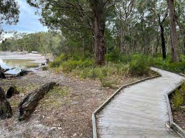
Photo: Tanilba Boardwalk (M. Rosenthal, 2023)
A potential governance structure for the CMP is outlined in Table 1-5
Table 1-5 Potential Governance Structure for the CMP
Organisation
Port Stephens Council
Responsibility
Lead agency for the development, coordination and implementation of the CMP.
Council’s CMP Steering Group is comprised of the following members (or assigned representatives):
Director Community Futures (Chair)
CMP Project Manager
Assets Section Manager
Strategy and Environment Section Manager
Communications and Engagement Coordinator.
The Steering Group may from time to time invite other staff members or external persons to attend meetings, if required.
State Government Agencies / Land Managers
NSW DCCEEW – Biodiversity, Conservation and Science Group (BCS)
DPHI – Crown Lands and Public Spaces
DPHI - Planning
DPI – Marine Parks
DPI – Fisheries
Worimi and Karuah LALCs
WCLB
NPWS
Hunter Local Land Services (LLS)
TfNSW (incl. Maritime Infrastructure Delivery Organisation or MIDO)
NSW State Emergency Service (NSW SES)
CMP Stakeholder Reference Group
Port Stephens Council
State Government Agencies (listed above)
The adjacent Councils, MCC and CN
Regional organisations (incl. Hunter LLS and LALCs)
NSW SES
Select community and user groups
Provide support with respect to recommendations for management, collaboration and action(s) for which they are nominated with a lead or supporting implementation role Engagement should be undertaken with the relevant authority when actions at the time of implementation where this is the case, or where they have a regulatory function such as the issue of any relevant approvals, permits or licences to enable the action to proceed.
Committee with a non-statutory role who are involved in coordination and oversight of the CMP planning and implementation, and who assist in facilitating local community and stakeholder involvement.
The Stakeholder Reference Group has an advisory role only, potentially as a committee of Council under Section 355 of the LG Act.
1.6 Review of Existing Information and Management Arrangements
The adequacy review of existing information and management arrangements for the Port Stephens coastal zone was undertaken during the CMP Stage 1 Scoping Study (PSC, 2020). The Stage 1 Scoping Study also identified additional studies and investigations that must be undertaken during Stage 2 of the CMP.
A first pass risk assessment was completed during preparation of the Stage 1 Scoping Study (PSC, 2020). Coastal threats and risks were identified through a review of background information, risk workshops with key stakeholders and community consultation. During the preparation of the CMP, the risk assessment was amended to reflect to the outcomes of the CMP as documented in the Stage 2 vulnerability and risk
assessments (BMT, 2021b) and the options development and engagement undertaken during Stage 3 (Rhelm and Bluecoast, 2023). The updated risk assessment findings are summarised in Section 2.2.
Management options and opportunities to mitigate the priority threats and risks to the Port Stephens coastal zone were developed during Stage 3 in consultation with the community and key stakeholders, as documented in the Stage 3 report (Rhelm and Bluecoast, 2023) and summarised in Section 3.1
2
A Snapshot of Issues
The Port Stephens coastal zone encompasses a wide range of environments, including:
• The Stockton Bight transgressive sand dunes (also referred to as a coastal dune field);
• The rocky headlands and embayed beaches of the open coast;
• The towns and villages scattered around the Port;
• The National Parks and Nature Reserves, including the Worimi Conservation Lands;
• The Port Stephens-Great Lakes Marine Park.
The coastal zone supports a diversity of activities and uses spanning residential, passive and active recreation, industrial and commercial, agriculture, fisheries, tourism and biodiversity conservation.
The Stage 1 Scoping Study (PSC, 2020) describes in detail the environmental, social and cultural, economic and future context for coastal management planning for Port Stephens. This sets the scope for the CMP and provided an increased understanding of the values of and priority threats to the study area.
Sections 2.1 and 2.2 of this report provide a summary of the values of the study area and the priority threats to these values, respectively. These were identified during preparation of the Stage 1 Scoping Study based on consultation with key stakeholders and feedback from the community.
Section 2.3 of this report provides a summary of the Stage 2 Vulnerability Assessment outcomes, which relate primarily to coastal hazards, addressing knowledge gaps identified in Stage 1 with respect to the Port Stephens LGA.
2.1 Values of the Study Area
The Stage 1 Scoping Study provides a review of the community and stakeholder engagement undertaken in relation to how the community value the coastal zone. The key coastal values have been synthesised and summarised and are presented in Table 2-1.
Table 2-1 Key Values of the Study Area
• Natural beauty, natural coastal landscapes
• Aboriginal cultural heritage and European heritage
Unique character
Public access & amenity
Sustainable development
• Visual amenity
• Conservation and scientific values
• Safe and accessible public open spaces along the foreshore for people to gather, socialise and participate in community activities
• Encourages an active healthy lifestyle
• Boating and fishing
• Water quality
• Maintenance of the local character and values
• Infrastructure to support the development, use and enjoyment of the coastal zone
• Economic activities, including agriculture, fishing, tourism and commercial sand extraction
• Sustainability and efficiency
Theme
Resilience
Biodiversity & ecosystem integrity
Equity & fairness
2.2 Threats to the Study Area
2.2.1 First-Pass Risk Assessment
Values
• Resilience of the natural and built environment to coastal and other natural hazards
• Resilience of the natural and built environment to climate change
• Important habitat for key species such as seagrasses, migratory shorebirds and koalas
• Wildlife corridors
• Coastal wetlands and littoral rainforest
• Good water quality and healthy ecosystems
• Access to the foreshore reserves, waterways and natural environment for all
There are a number of threats to the Port Stephens coastal zone, its coastal uses and values. A key outcome of the Stage 1 Scoping Study (PSC, 2020) was to understand and prioritise the threats to the coastal zone. The list of threats was developed from a range of sources of information, including community and stakeholder feedback, and the level of risk from each threat was evaluated for different planning horizons.
The first-pass risk assessment undertaken in Stage 1 adopted Council’s Corporate Risk Matrix, modified to include additional descriptors, enabled an assessment of risk to the wider community within the study area.
The Stage 1 Scoping Study considered 16 key threats with respect to both the environmental and socioeconomic impacts for each of the three parts of the study area individually. Risk was evaluated for the present day for each of the three parts of the study area individually, and for the study area as a whole for a future planning horizon. Aspects considered in the risk assessment included:
• The effects of climate change;
• The local and regional-scale effects of coastal processes;
• The ambulatory and dynamic nature of the shoreline;
• Population growth and demographic changes; and
• Projected use and development of the coastal zone.
The key threats to the coastal zone identified through a literature review and via engagement with key stakeholders that were considered in Stage 1 Scoping Study (PSC, 2020) included:
• Beach erosion (referred to hereafter as ‘coastal erosion’, consistent with the CM Act and CM Manual);
• Aeolian sand inundation (referred to hereafter as ‘inundation with’ or ‘accretion of’ wind-blown sand);
• Coastal inundation (which was assumed to include tidal inundation);
• Cliff / slope instability;
• Marine sand inundation (referred to hereafter as ‘accretion of marine sand’);
• Urban stormwater runoff;
• Acid Sulfate Soils (ASS) runoff;
• Agricultural runoff;
• Point source discharges;
• Marine debris;
• Land clearing;
• Weeds, pests and diseases;
• Land contamination;
• Mining and extractive industries;
• Boating pressures; and
• Encroachment onto public land.
2.2.2 Threats Refined by Stage 2 Vulnerability Assessments
Stage 2 of the CMP (BMT, 2021a) undertook a range of coastal hazard and vulnerability studies to build on the risk assessment undertaken in Stage 1.
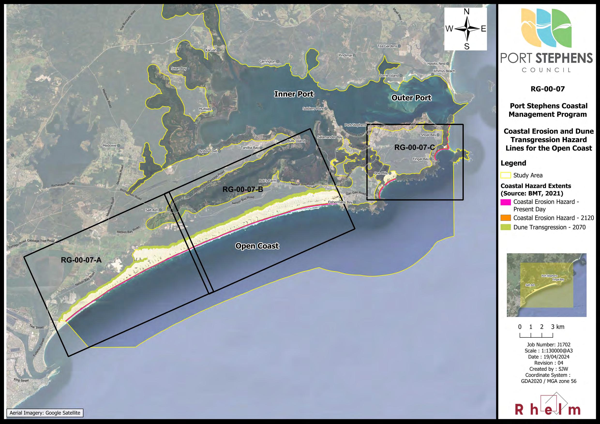
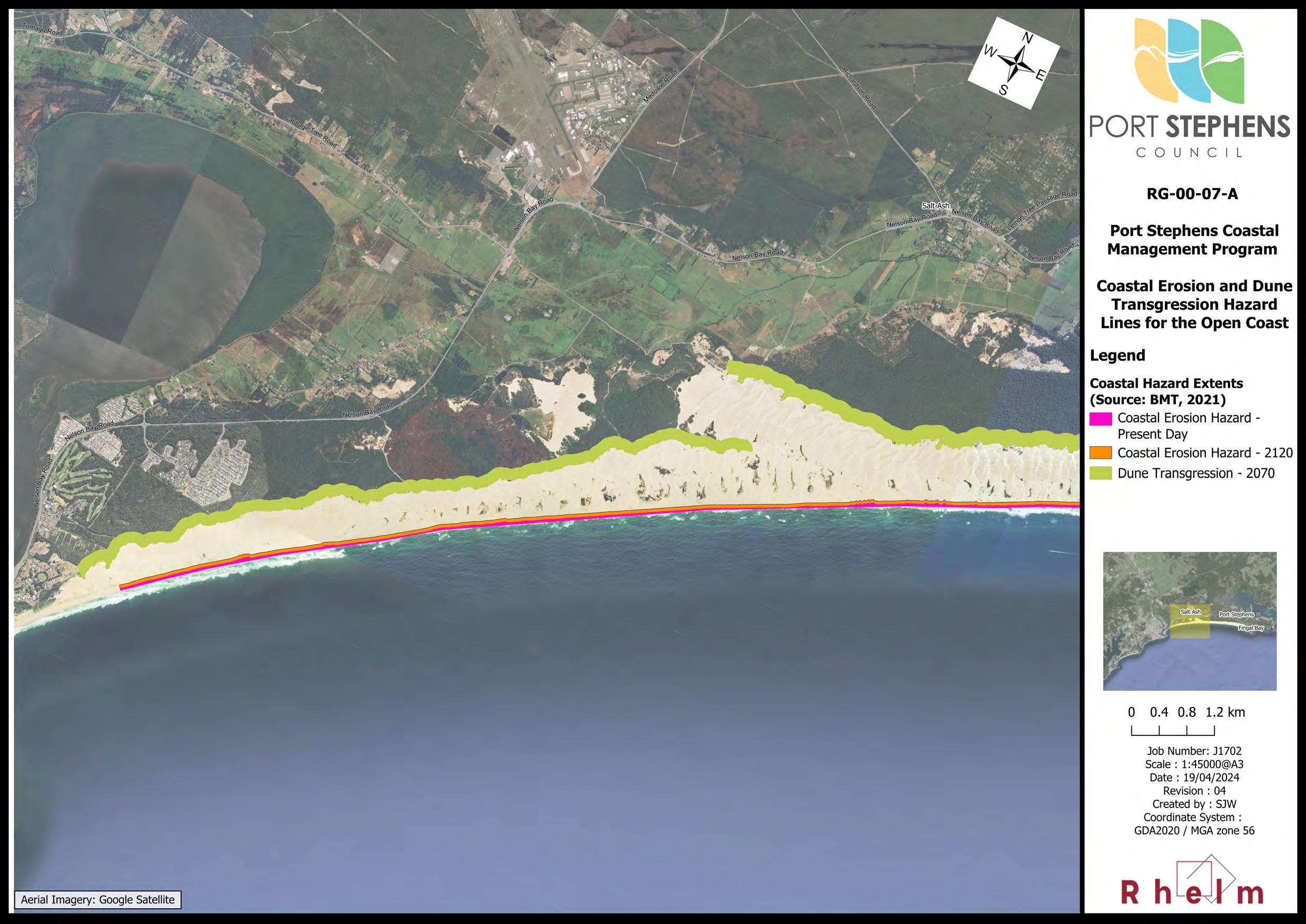
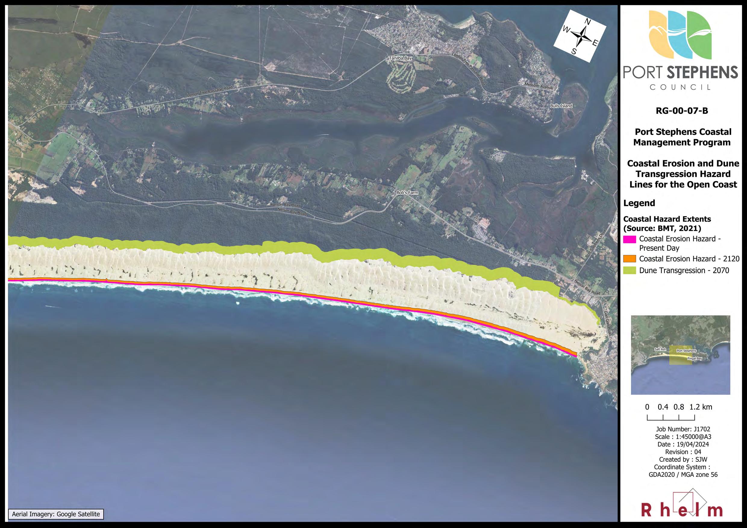
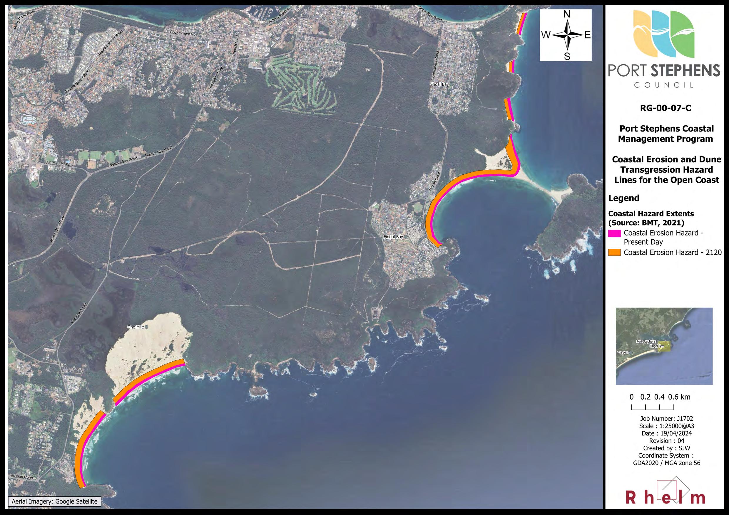
The work undertaken in Stage 2 included a probabilistic assessment of beach erosion and shoreline recession to derive probable coastal erosion hazard lines (or extents). The coastal erosion hazard lines were prepared for the Open Coast area only. Coastal erosion is the sum of:
• Beach erosion - which occurs over a period of days during a coastal storm event. Once the storm passes, the beach then gradually recovers over a period of months or years as the sand is transported back onto the beach under normal wave conditions.
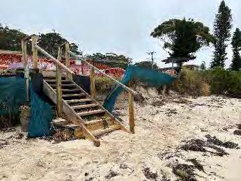
Photo: Dune vegetation impacted by informal access (foreground) and aeolian sand transport (or dune transgression, see mid-right), One Mile Beach (M. Rosenthal, 2023)
• Shoreline recession – which results from a net loss of sand and occurs over a period of years to decades. If a very big storm has occurred, the sand eroded from the beach may be taken too far away and unable to make it back onto the same beach. If there is no new sand coming into the system, this can become a permanent loss of sand and the coastline gradually moves landward. Higher water levels due to sea level rise will accelerate shoreline recession
The ‘most likely’ coastal erosion hazard lines for the present day and the 2120 planning horizon are mapped for the Open Coast in Map Set RG-00-07 A to C (refer Appendix A).
A semi-qualitative assessment of risk from coastal erosion was undertaken for the Outer Port only, but no erosion hazard lines were developed for these locations. No erosion hazard assessment was undertaken for the Inner Port
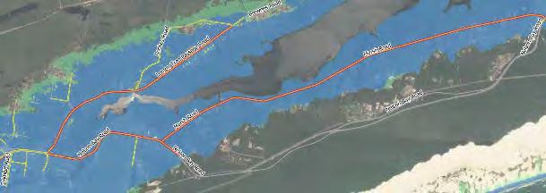
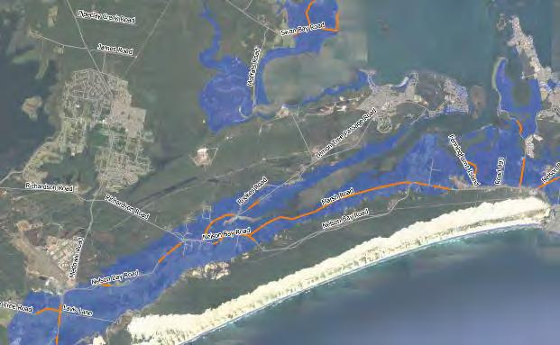
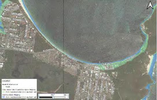
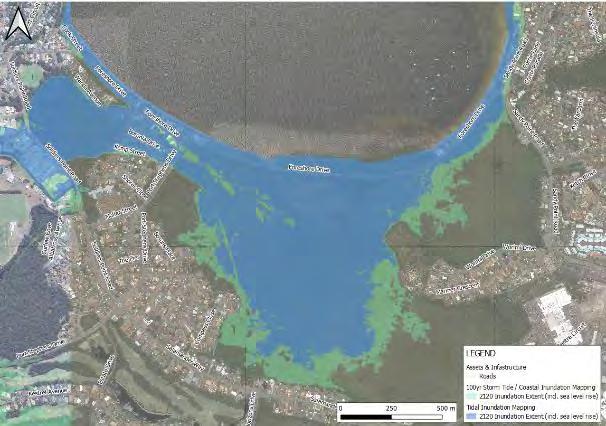
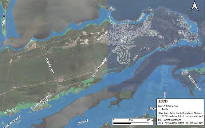
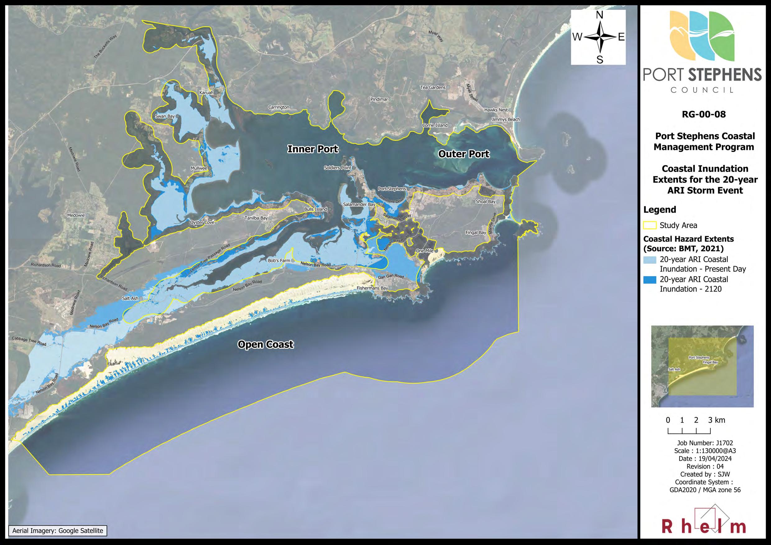
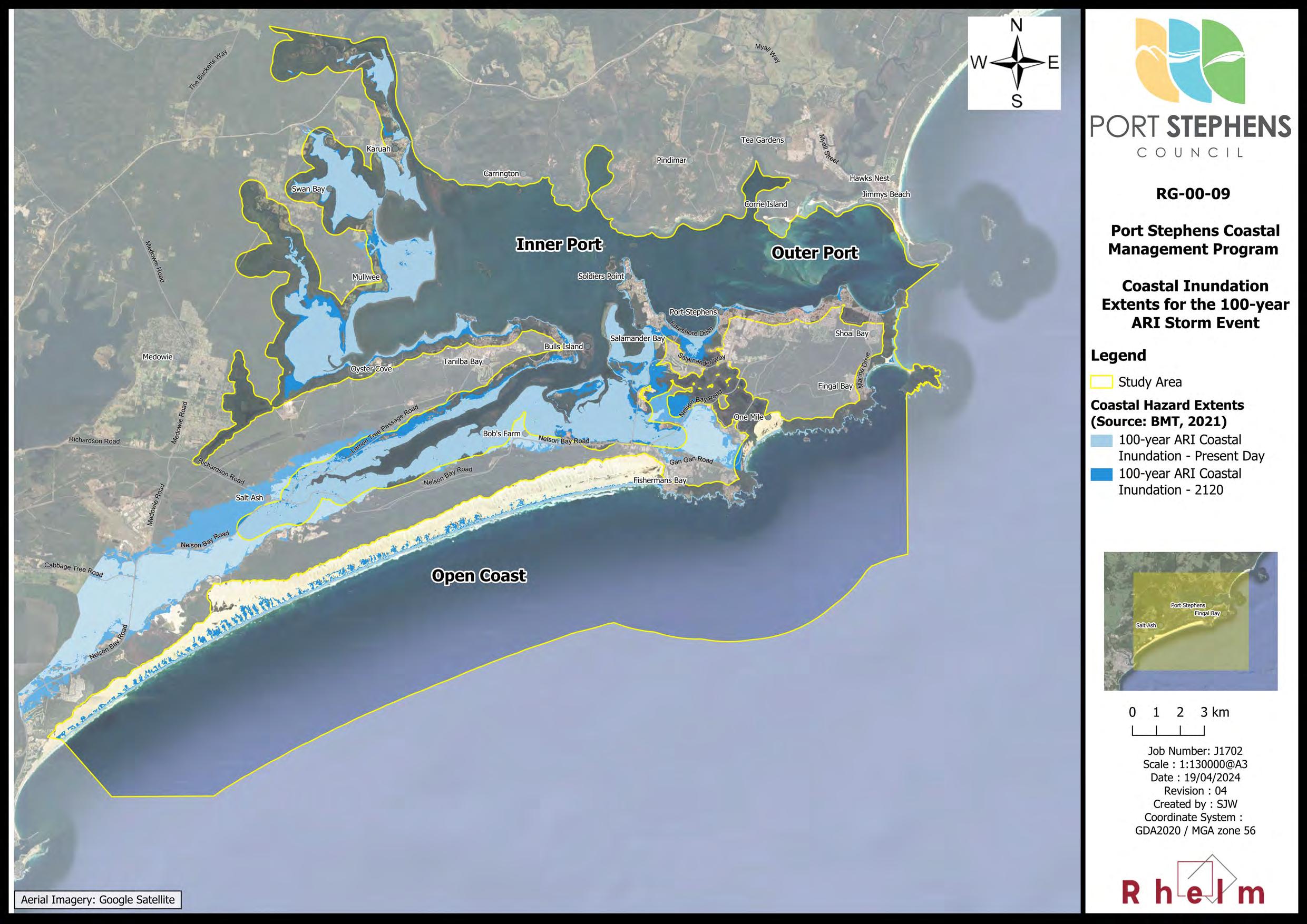
A coastal inundation assessment which considers elevated ocean water levels (storm tide) for the 20-year Average Recurrence Interval (ARI) and 100-year ARI storm events. Coastal inundation is primarily associated with storms resulting in storm surge and waves. It means that ocean levels rise above normal elevations and inundate low-lying areas by overtopping dunes, structures and barriers. The duration of coastal inundation may be several hours and will vary depending on the timing of the storm (e.g., if storm surge peaks on the high tide). Once the coastal storm passes, the water recedes, and ocean water levels return to their normal tidal levels. The risk of coastal inundation will increase as sea levels rise. The ‘expected’ 20-year ARI and 100-year ARI coastal inundation extents are mapped in Map RG00-08 and Map RG-00-09 (refer Appendix A), respectively.
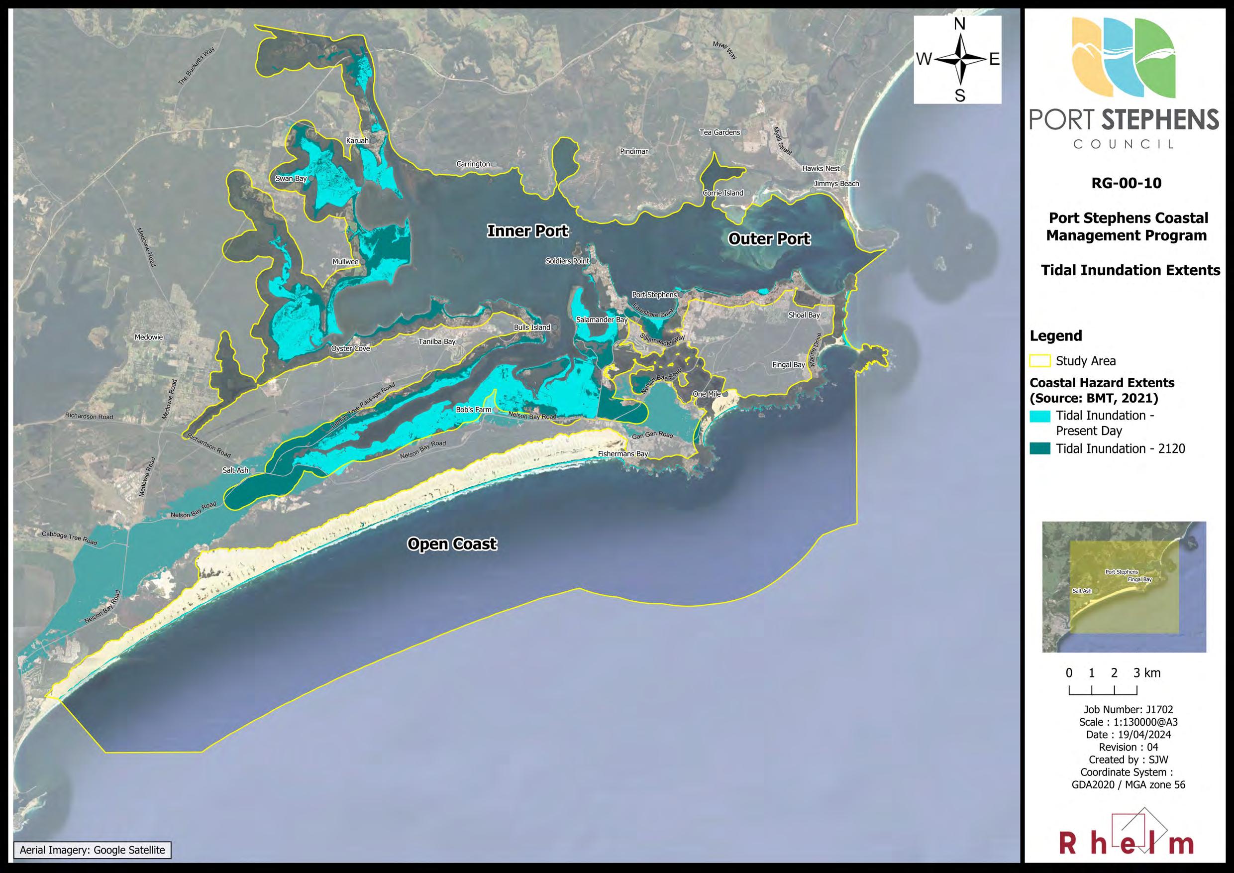
A tidal inundation assessment, which adopted the Highest Astronomical Tide (HAT) to show areas that are vulnerable to inundation by the regular astronomical tides. Low-lying land would be inundated for a period of hours during the highest tidal water levels. Under sea level rise conditions, the extent of tidal inundation will increase, and low-lying areas will become permanently inundated. The ‘expected’ tidal inundation extents corresponding to the HAT are mapped for the present day and 2120 in Map RG-00-10 (refer Appendix A).
An assessment of dune transgression at Stockton Bight was undertaken, which developed hazard set back lines. Dune transgression is the landward movement of sand due to aeolian (wind) transport. The dune transgression hazard lines for the 2070 planning horizon are mapped for the open coast in Map RG-00-07 A and B (refer Appendix A). While the 2120 dune transgression hazard extents were mapped by BMT (2021a), it was noted there is some uncertainty associated with the progression of dune transgression at this time, and hence the 2120 dune transgression extents are not presented in this report.
While dune transgression (aeolian sand transport more generally) is not defined as a ‘coastal hazard’ under the CM Act, it is a key threat to the use and values of the Port Stephens coastal zone and was therefore included in the category of ‘Coastal Hazard Threats’ in Table 2-2
The hazard assessments described above considered the present day (2020), 2040, 2070 and 2120 planning horizons, taking into account sea level rise under climate change conditions.
2.2.3
Key Threats to the
Port Stephens Coastal Zone
As an outcome of the additional studies, information and stakeholder inputs received in Stages 2 and 3 of the CMP, the risk assessment was updated as part of Stage 3 of the CMP (Rhelm and Bluecoast, 2023).
The outcomes of the updated threat and risk assessment for the Port Stephens coastal zone are summarised in Table 2-2.
The full risk assessment (including descriptions of each threat) is provided in the CMP Stage 3 Report (Rhelm and Bluecoast, 2023).
Table 2-2 Risk Assessment Outcomes
Coastal Hazard Threats
CH Threat 1 – Beach erosion
CH Threat 2 – Shoreline recession
CH Threat 3 – Inundation with wind-blown sand
CH Threat 4 – Coastal inundation
CH Threat 5 – Tidal inundation
CH Threat 6 – Cliff / slope instability
CH Threat 7 – Accretion of marine sand
Water Quality Threats
WQ Threat 1 – Urban stormwater pollution
WQ Threat 2 – ASS runoff
WQ Threat 3 – Agricultural runoff pollution
WQ Threat 4 – Point source discharge
WQ Threat 5 – Marine debris
Biodiversity Threats
Threat 1 – Land clearing
Threat 2 – Biosecurity
Development and Industry Threats
Threat 1 – Mining & extractive industries
Activity Threats
Threat 1 – Boating pressures
RA Threat 2 – Encroachment onto public land
2.3 Snapshot of Issues for Each Coastal Management Area
Table 2-3 identifies the coastal management issues that arise within each of the four CMAs, recognising that some issues may affect more than one area.
Table 2-3 Key Coastal Management Threats Within Each Coastal Management Areas
Coastal Management Area (CMA)
Coastal Wetlands and Littoral Rainforests Area (incl. proximity area)
CH Threat 5
WQ Threats 1-4
BD Threats 1 & 2
RA Threat 2
Coastal Vulnerability Area (CVA)
All CH Threats
BD Threat 1
ME Threat 1
RA Threat 2
There are extensive areas of Coastal Wetlands and small areas of Littoral Rainforest in the study area (Section 1.3.1).
The identified threats present a risk to the ecosystem health, biodiversity, resilience and longterm functioning of these areas.
While there is currently no CVA mapped for the study area under the Resilience and Hazards SEPP, the extent of land vulnerable to coastal hazards has been identified through the Stage 2 vulnerability studies (BMT, 2021a) and is mapped in map sets RG-00-07 A to C, RG-00-08, RG-0009, and RG-00-10.
The ambulatory and dynamic nature of the shoreline has been considered in the CMP via evaluation of coastal processes to inform management responses, including consideration of how coastal hazards will increase due to climate change.
Of the coastal hazard threats the key ones are:
• Beach erosion;
• Shoreline recession;
• Inundation with wind-blown sand (and including dune transgression and nuisance sand accretion due to aeolian processes);
• Coastal inundation;
• Tidal inundation; and
• Accretion of marine sand.
These coastal hazards present a risk to public safety, a risk to life, and a risk to built and natural assets.
On the open coast, beach erosion due to cross-shore sediment transport that occurs due to wave activity (particularly during coastal storms) is the key issue. Dune transgression (major sand drift) is also a key issue. Affected locations include the portion of the Stockton Bight coastal dune field that falls within the study area and One Mile Beach. Sand mining of the extensive dune systems also occurs in the Stockon Bight.
Within the Inner and Outer Port, coastal erosion is less of an issue due to the sheltered nature of the waterway, although complex sediment transport processes lead to shoreline recession and recovery from short-term beach erosion events (although relatively minor) can be limited in the low wave energy environment.
The key hazards are coastal and tidal inundation, which affect large areas of low-lying land throughout the study area, an impact that will escalate as rise in mean sea level occurs, with implications for the long-term viability of some current uses of the coastal zone.
Loss of vegetation and disturbance, whether associated with sand mining, improper public access, encroachment, recreational 4WDs, or other activities, can materially reduce the resilience of dunes and estuarine foreshores to coastal erosion and dune transgression. These threats may also impact Aboriginal cultural heritage sites, ceremonial and other important locations, resources and other activities.
All stakeholders and the community play an important role in managing these threats to the coastal environment and to appropriately reducing risk and improving resilience to coastal hazards.
The main threats to the Littoral Rainforest relate to their proximity to urban development.
Coastal Wetlands are subject to pressure from urban development and agriculture, particularly with respect to water quality impacts and modifications to wetland hydrology. The latter will become an increasing concern under climate change conditions due to sea level rise and changes to rainfall patterns.
The key locations identified as being affected by coastal and/or tidal inundation in the Stage 2 vulnerability studies (BMT, 2021a) include:
• Large parts of the Tomaree Peninsula including Anna Bay and Bobs Farm;
• Large parts of the Tilligerry Peninsula including Lemon Tree Passage, Salt Ash and parts of Tanilba Bay;
• Salamander Bay and Taylors Beach; and
• Swan Bay and Karuah.
Key locations identified as being affected by coastal erosion in the Stage 2 vulnerability studies (BMT, 2021a) include:
• The Open Coast beaches;
• Shoal Bay and Nelson Bay Beaches; and
• Sandy Point / Corlette and Soldiers Point.
Council proposes to adopt a CVA under the Resilience and Hazards SEPP for the study area.
Coastal Wetland and Littoral Rainforest Areas are mapped in maps Map RG-00-02 and Map RG-00-03 respectively.
(CMA)
(CEA)
Use
All CH Threats
All WQ Threats
All BD Threats
LC Threat 1
ME Threat 1
All RA Threats
CH Threats 3, 5 and 7
The CEA encompasses most of the Port Stephens coastal zone.
There is a diverse range of identified threats to the CEA, relating to water quality threats, development and land use, recreational activities, and some coastal hazards. These threats are adversely impacting terrestrial and aquatic ecosystem health and resilience and biological diversity within the study area. This is of particular concern in relation to conservation significant communities, populations and species, of which there are many located within the study area. These include:
• Various National Parks and Nature Reserves;
• The Port Stephens-Great Lakes Marine Park as a whole;
• Estuarine macrophytes and other aquatic habitats, including Endangered populations of Posidonia australis seagrasses, sponge beds and soft corals;
• A significant population of, and habitat for, Koalas;
• Significant shorebird and wader bird habitat areas; and
• Extensive coastal wetlands and dune systems.
Key impacts on these environmental values arise from urban development, agricultural activities, recreational activities (including boating), and pests and weeds.
As detailed below, some of the key locations where recreational activities (including 4WD vehicle access) are adversely impacting ecosystems includes the Stockton Bight, One Mile Beach, and the foreshores of the Inner Port, which are heavily utilised by residents and visitors. These activities can result in damage to and loss of vegetation, damage to dune structures, spread of pests and weeds, wildlife strike, and disturbance of native animals (e.g., nesting shorebirds).
Boating activities result in a range of impacts including wildlife strike, water quality impacts, damage to foreshore vegetation and estuarine macrophytes (e.g., via moorings or propellor damage), and general wildlife disturbance.
Pest and weed management and water quality are issues of key concern to stakeholders and the community, and there is a desire to protect and enhance the natural environment of Port Stephens to support ecosystem health and biodiversity.
Coastal hazards including coastal erosion and coastal inundation, although naturally occurring processes, may from time to time impact coastal ecosystems; however, this would generally be considered to reflect natural variation. In contrast, tidal inundation associated with climate change induced sea level rise has potential to adversely a range of ecosystems, including estuarine macrophytes and terrestrial vegetation within the projected inundation extents.
Some of the key locations where conflict over access to resources are occurring include:
• Important cultural sites located in National Parks;
The CUA encompasses much of the Port Stephens coastal zone. Threats to this CMA identified in the CMP relate to visual and landscape character, economic uses of the coastal zone, recreational activities, and social and cultural values.
In 2021 the population of the Port Stephens LGA comprised 76,414 people (ABS, 2023). The population is growing and is projected to reach 93,658 people by 2041, corresponding to an average annual increase of 1.1%, which is higher than the NSW average (DPHI, 2024). Of note is the high proportion of people over the age of 60, including retirees, in the study area.
Tourism, recreational and commercial fishing and sand mining are major economic uses of the coastal zone. Tourism in particular can contribute to significant increases in population. According to the Port Stephens 2016/17 Tourism Monitor, over that period the LGA had 1.31 million visitors, around half of which were overnight visitors. These seasonal increases in population can place pressure on resources, services and utilities.
Traditional Owners play an important role in Caring for Country, such as via the Worimi Lands Conservation Board. There is significant opportunity to improve collaboration with, and involvement of, Traditional Owners in coastal management and to facilitate improved access to Country (in particular Sea Country), and there is frustration amongst First Nations people about these issues. Effective coastal management cannot occur without the involvement of Traditional Owners.
• Traditional fishing grounds located in the Marine Park and other important cultural resources and cultural sites;
• Where recreational and commercial boating activities co-occurs with aquaculture operations;
• Along the Stockton Bight, where recreational use adversely impacts heritage sites, the dune ecosystem, nesting shorebirds and eco-tourism activities;
• Encroachment by private landholders on public land through inappropriate land clearing (e.g., mowing of public reserves, etc.) and construction of foreshore structures, which can prevent or reduce public access to or along the foreshore, including from the foreshore to the water; and
• Improper public access to beaches that results in loss of foreshore and dune vegetation and reduced coastal resilience. Key sites include One Mile Beach and Fingal Bay, amongst others.
Council undertakes a range of activities to manage encroachment and improper public access, and to ensure public safety and ongoing access to beaches and coastal reserves, including:
• Dune rehabilitation, foreshore management and sand management activities; and
• Supporting DuneCare and LandCare volunteers.
In addition, all coastal hazards to some extent affect the use of the coastal zone, more so in some localities than others. For example:
• The accretion of marine sand can impact navigation around boat ramps and jetties;
• The accretion of wind-blow sand can impact the use of recreational facilities and ability of SLSC’s to deploy equipment (e.g. One Mile Beach); and
• Coastal erosion can impact public access and damage access stairs.
3 Actions to be Implemented by
the Council or by Public Authorities
3.1 Evaluation of Coastal Management Options
The CMP process detailed in the CM Manual (OEH, 2018b) involves councils identifying coastal management issues affecting the area to which the CMP is to apply and identifying coastal management actions required to address those coastal management issues in an integrated and strategic manner. The aim is to develop strategies and identify coastal management actions that address coastal management issues, reduce exposure to coastal hazards, and to take advantage of opportunities, consistent with provisions in Clauses 14 and 15 of the CM Act. Councils also decide the priority of identified coastal management actions and propose integrated and strategic delivery pathways.
The process prescribed in the CM Manual follows four steps, summarised in Figure 3-1.
Figure 3-1 Options Identification and Evaluation Process (after: OEH, 2018b)
Stages 1 and 2 of the CMP (including the engagement activities undertaken) developed an understanding of the coastal management issues, including an analysis of the risks, vulnerabilities and opportunities in the study area As per Step 1 in Figure 3-1, the key values, risks and opportunities identified (Section 2) provided the basis for the strategic direction of the Port Stephens CMP (Sections 1.4 and 3.1.1).
Stage 3 of the Port Stephens CMP has involved identification and evaluation of management options, as per Steps 2 and 3 in Figure 3-1, to select preferred coastal management actions for inclusion in the CMP with a focus on achieving the objects of the CM Act (Table 1-2) and alignment with management objectives for CMAs under the Resilience and Hazards SEPP (Table 1-3).
Community and stakeholder engagement informed this process through the identification of options at workshops and meetings (refer Appendix B).
The Stage 3 report (Rhelm and Bluecoast, 2023) provides a more comprehensive summation of the options development and evaluation process.
3.1.1 Confirm Strategic Direction
The purpose of a CMP is to set the long-term strategy for the coordinated management of land within the coastal zone with a focus on achieving the objects of the CM Act. The long-term strategic direction for the Port Stephens coastal zone is articulated in the vision that has been developed for the CMP, which is supported by a series of local coastal management objectives aligned with the CM Act. The vision and objectives are presented in Section 1.4.
The strategic context for coastal management of the Port Stephens coastal zone is defined in detail in the Stage 1 Scoping Study (PSC, 2020), which sets the environmental, social, cultural, economic, governance and planning context for coastal management. This includes consideration of demographics, housing and settlement patterns, regional strategic planning, tourism, recreation, environmental conservation and Aboriginal cultural heritage, and how each of these aspects may change over time. All these aspects have been considered by Council in the development of this CMP including evaluation of threats and its long-term strategy which includes management actions around knowledge building (e.g., CH001 and CH072) and planning for change (e.g., CH011 and CH005).
3.1.2 Identifying Options
A total of 158 management options were developed based on a review of the implementation status of the relevant existing coastal studies and plans of management that had been prepared for the study area, the outcomes and recommendations of the Stage 2 vulnerability assessments and engagement with the community, key stakeholders and Traditional Owners.
The full list of management options and information on how they were identified (i.e., ‘source of option’) is provided in Appendix D of the Stage 3 report (Rhelm and Bluecoast, 2023). The following details are provided for each option:
• A unique identifier in the form of an ‘Option ID’ number for tracking through the options evaluation process;
• An option description, including the option location (which was mapped, where feasible);
• The key coastal threat that the option addresses;
• The CMA(s) to which the option applies; and
• The category applicable to the management option (i.e., Alert, Avoid Future Impact, Active Intervention, Planning for Change, Emergency Response).
3.1.3 Evaluating Options
The CM Manual recommends councils undertake a methodical and transparent evaluation process to select and adopt the most appropriate coastal management options as actions in the CMP. It is recommended that proposed coastal management options be evaluated in relation to feasibility, viability and acceptability. An overview of the options assessment process, which was adopted in this CMP, is illustrated in Figure 3-2
The long list of 158 options identified in Stage 3 of the CMP were subject to assessment for feasibility, viability and acceptability.
The first step was the feasibility assessment, which comprised a first-pass screening of all options to ‘rule out’ any options that did not address an existing (or future) risk to the coast or were in some other way infeasible and to consolidate overlapping options.
The viability assessment was undertaken for those options that progressed through the feasibility assessment and comprised:
• A multi-criteria assessment based on how well the option addressed coastal threats and its alignment with the CMP management objectives; and
• A simplified ‘value for money’ assessment with respect to the relative cost of implementation over the 10-year CMP.
None of the management options were subject to detailed cost-benefit analysis (CBA), preliminary design or viability analyses (e.g., modelling). It was considered that none of the options were sufficiently high cost, complex or high risk to necessitate such analyses.
This section summarises the options assessment process and outcomes, which are more comprehensively documented in the Stage 3 report (Rhelm and Bluecoast, 2023).
Figure 3-2 Staged Option Evaluation Process (after: OEH, 2018b)
3.1.3.1
The Feasibility Assessment
The feasibility of each of the management options was evaluated for their legal, technical and engineering feasibility (including confidence in performance) in relation to the objectives and intended outcomes. This evaluation was undertaken using the guidance in the CM Manual, by assessing the options against the criteria shown in Table 3-1.
Table 3-1 Feasibility Assessment Criteria
Feasibility Criteria CM Manual Guidance
Demonstrates how the CMP gives effect to the objects of the CM Act and management objectives of the coastal management areas
Statutory and policy compliance
Engineering feasibility
Reduces risk
Would be permissible under the legislation
Comply with policy requirements at local, state and Commonwealth levels
Are feasible in engineering terms (i.e., a structure can realistically be built, given the local process context)
Are broadly able to be implemented, in terms of available capacity and capability, and would address the intended issue
Can address the identified threats and risks to the coastal zone, or enhance opportunities, based on previous experience / professional judgement
Are likely to contribute new knowledge for effective and adaptive management; for instance, a response that is structured as a carefully controlled trial of new technology
When evaluating the feasibility of the options, the following aspects were also considered in consultation with Council and NSW DCCEEW:
• The timeframe over which a management option would remain effective and if there are any limits to the effectiveness of the option (e.g., is there a threshold beyond which the response would fail or is rendered obsolete?);
• Evidence from application of the option in similar situations;
• The potential for any unintended or unanticipated negative consequences (sometimes referred to as perverse outcomes or maladaptation);
• Whether the option is irreversible and locks in a specific future action or adaptation pathway;
• Alternatively, whether the option is a low risk or ‘no regrets’ option, one that would be beneficial to implement irrespective;
• The level of expertise required to evaluate the design, implementation, monitoring and review of actions;
• Whether the selection of a strategy allows for adaptive management.
The feasibility assessment outcomes are provided in Appendix E of the Stage 3 report (Rhelm and Bluecoast, 2023). The feasibility assessment short-listed a total of 64 feasible options to progress to the viability assessment.
3.1.3.2
The Viability Assessment
The viability of coastal management options was assessed on a largely qualitative basis via a multi-criteria analysis (MCA).
The criteria adopted for the MCA were driven by:
• The need to confirm consistency with the CM Act and the requirements of the CM Manual;
• The need to ensure the CMP contains actions that can be funded and implemented; and
• Consideration of the likely acceptance by the key stakeholders and the community (i.e., the acceptability assessment).
The MCA involved evaluation of:
• Threat Mitigation Score (effectiveness) – based on scoring of the option with respect to how well it addressed each of the threats listed in Table 2-2. The scores were weighted based on the risk rating for the coastal threats (i.e., threats with a ‘very high’ level of risk were given a higher weighting than those with a ‘low’ level of risk);
• Achievement of the management objectives (benefits realisation) – each option was scored as to how well it would contribute to positive social, environmental and economic outcomes as articulated by the objectives, or if it would have adverse impacts on benefits realisation;
• Acceptability score (community and stakeholders) – estimates the likely community and stakeholder acceptance of the option based on Council’s previous experience with the community and inputs received during community and stakeholder engagement activities undertaken as part of Stages 1 to 3 of the CMP. This score will be updated as an outcome of the Stage 4 engagement activities; and
• Cost score – was applied as a weighting to the total score (being the sum of the scores for each of the criteria listed above) as an indication of ‘value for money’, whereby less expensive options and/or those that achieved the greatest benefits and risk reduction were weighted higher.
A CMP is also required to consider projected population growth and demographic changes. However, the population of the Port Stephens LGA (75,253 people as at 2021; DPHI, 2024) is expected to experience relatively modest growth rates of 1.1% per annum up to 2041. Hence, it was considered that explicit consideration of population growth in the MCA was not necessary. Similarly, potential future changes in demographics were not included in the MCA as it is considered such changes are difficult to predict in the post-COVID environment with the increase in remote-working and ability of younger people to move further away from larger cities (and noting also the higher proportion of the population aged 60 years and over)
Based on the outcomes of the viability assessment, Council’s Project Steering Group for the CMP determined to proceed with the majority of management options in the ‘short-list’ that went to viability assessment. The viability assessment allowed for:
• The selection of the highest ranking of mutually exclusive options; and
• The identification of lower priority options within the context of the available resources for implementation of the CMP.
Further, as part of the viability assessment, a number of options that had proceeded through the feasibility assessment, were identified to have in fact already been completed. Others were identified as no longer relevant.
The viability assessment resulted in a total of 60 management options being recommended for inclusion as management actions in this CMP.
As a result of public exhibition of the CMP a further seven management actions were included in the CMP, resulting in a total of 67 management actions being recommended for adoption in the CMP. The seven additional management actions are listed below:
• Action CH085 (Adopt a CVA for the study area) – As a result of further consultation with DPHI –Planning, Council determined to proceed with a CVA for Port Stephens;
• Action CH084 (Update CMA mapping) – This action was included at the suggestion of DPHI –Planning to provide a mechanism for updates to the CMA mapping under the Resilience and Hazards SEPP as a result of new information arising from studies undertaken under this CMP or other activities undertaken by Council;
• Action CH007 (Works to stabilise the frontal dune system on Worimi Conservation Lands) – This action, originally considered in Stage 3, was adopted in the CMP with amendments following further consultation with WCLB and NPWS;
• Action E020 (Undertaken environmental protection works in CWLRAs on Council controlled land) –The purpose of this action is to streamline the environmental planning approvals process for ‘environmental protection works’ in CWLRAs under the Resilience and Hazards SEPP;
• Action E021 (Develop a Management Plan for CWLRAs located on Council controlled land) – While Action E020 enables ongoing environmental management and rehabilitation of these CWLRAs, it is considered appropriate to develop a more detailed Plan of Management for the subject land to identify required management activities and priorities for management, commensurate with the values associated with these CWLRAs;
• Action RA046 (Advocate for State Government commitment to funding maintenance and navigational dredging of Corrie Channel) – There is currently no ongoing financial commitment in place for this work, and both Port Stephens and MidCoast Council propose to advocate for longterm funding to be allocated by the State Government. This Action was requested via a submission from MidCoast Council; and
• Action WQ001 (Design a water quality monitoring program for Port Stephens) – This action was originally considered in Stage 3 of the CMP but was at the time not supported due to a proposal to adopt a water quality monitoring program under Action WQ003 of a more limited scope. However, on further discussion with Council, it was considered that there would be benefit to more careful consideration of a broader and more rigorous monitoring program that targets aquatic ecosystem health as well as human health, which would require a review of existing water quality data and development of a monitoring program consistent with NSW DCCEEW’s new risk-based framework. The action was then endorsed by Council for adoption in the CMP.
3.2 Recommended Management Actions
3.2.1 Overview
Management strategies and actions have been developed for an initial 10-year period for the CMP.
The management actions have been categorised in terms of the key threats (Section 2.2) being addressed. A timeframe for implementation of the actions is specified, using time that is equivalent with the key Council Integrated Planning and Reporting (IP&R) framework documents, as follows:
• Year 1 – to align with the Operational Plan (which typically extends for one financial year);
• Years 2 to 4 – to match with the Delivery Program which is a four-year program (including the Operational Plan);
• Years 5 to 10 – to match with the Resourcing Plan which is a 10-year financial plan;
• The term ‘ongoing’ is used where an action will need to be repeated regularly.
Actions are presented in terms of actions to be implemented by Council (Section 3.2.2) and by other public authorities (Section 3.2.3).
All recommended actions that have a specific location associated with them are shown on map series RG-0011. All actions in this CMP only apply to areas within the coastal zone.
The following information is provided for each management action:
• Action ID;
• Action name and description (detailed descriptions are provided for select actions in Section 3.2.4);
• Coastal Management Area;
• Location(s) for implementation;
• Indicative (capital and annually recurrent) costs;
• Responsible and supporting organisations;
• Proposed year of implementation; and
• Performance measures.
Where environmental protection works are proposed, it has been assumed (and identified) that these may occur within the CWLRA.
3.2.2 Actions to be Implemented by Council
There are 61 management actions for implementation by Council, including:
• 28 actions that address Coastal Hazard Threats, including one action that provides for implementation of the CZEAS;
• 16 actions that address Recreation and Access Threats;
• 9 actions that address Biodiversity Threats;
• 7 actions that address Water Quality Threats;
• 1 action that addresses a Mining and Extractive Industries Threat
The management actions for implementation by Council are presented in Table 3-2
There is opportunity to build knowledge on the impact of coastal hazards on Port Stephens including long-term climate change. Monitoring will also inform adaptive management as identified in this CMP. The monitoring should consider:
• measuring the impacts of climate change,
CWLRAs, CEA, CUA
Develop and implement a coastal hazard monitoring strategy.
CH002
CEA, CUA
Develop and implement a program for monitoring the condition of coastal structures owned and/or maintained by Council.
• improving understanding of coastal processes and the impacts of events on the coastal zone,
• tracking change or identifying trends, and
• identifying if triggers for adaptive management have been reached for relevant management actions.
This action is linked to action CH009, which proposes an additional CoastSnap monitoring station as part of Council's existing suite of CoastSnap locations. The CoastSnap data and analyses should form part of the monitoring program.
Further information on this action is provided in Section 3.2.4
This action will provide for the ongoing monitoring of Council's coastal structures as part of their asset management system. The monitoring framework will in the first instance require a survey to establish the baseline condition of existing structures, building on the survey undertaken for Stage 2, the BMT (2021b) Coastal Structures Audit. The outcomes of the monitoring could be used to inform any remedial or maintenance works required for the structures.
CH005 Coastal Wetland Area, CEA, CUA
For those Aboriginal cultural heritage sites and Aboriginal Places located on Council land or Crown land for which Council is the Reserve Manager, work with Traditional Owners to evaluate the level of risk and develop a plan to manage the impacts to cultural heritage from coastal hazards, including sea level rise.
Prepare a climate change adaptation strategy for the Tilligerry Peninsula in consultation with the local community and key stakeholders. The output of the strategy will be an agreed and costed adaptation pathway that identifies thresholds and triggers for action.
CH009
CWLRAs, CEA, CUA
Install an additional Coast Snap monitoring point at Fingal Beach.
A similar study is currently underway for the Worimi Conservation Lands and this study proposes to evaluate risk to sites located on Council land and Crown land managed by Council.
PSC NA Year 1 and ongoing Annual reporting of
CH011
CWLRAs, CEA, CUA
Prepare a planning proposal to incorporate provisions to manage the risk to life and properties from coastal hazards for inclusion in the Port Stephens LEP 2013 and update the DCP 2014 accordingly.
Large areas of land along the Tilligerry Peninsula are subject to coastal inundation in the present day, a risk that will increase in future. In addition, the low-lying land of the peninsula is also at risk from permanent tidal inundation. This has implications for the overarching approach for managing risk from all coastal and flood hazards.
Further information on this action is provided in Section 3.2.4
Coast Snap monitoring points provide valuable data about shoreline changes over time. There are already official CoastSnap points at Shoal Bay, Nelson Bay and Birubi Point.
To provide mitigation of risk to life and property arising from coastal hazards for existing and proposed development.
This management action is discussed further in Section 4
All PSC NA Year 4 Hazard and risk assessment completed.
Ongoing monitoring and analyses of CoastSnap sites.
Successful planning proposal; adoption of LEP and DCP amendments.
CH001
CH003 CEA, CUA
CH012 CWLRAs, CEA, CUA
Document a long-term strategy for local and regional roads under the care and control of Council that are key access roads at risk from tidal inundation aimed at the ongoing provision of access for the community in future.
Undertake investigations to assess the risk to Shoal Bay Road from coastal erosion and evaluate the feasibility of different strategies to manage the identified risk. Based on the outcomes of the investigations, identify a suitable option to progress to detailed design.
Progress investigations, detailed design and costings for priority options from the Whitehead and Assoc. (2015) Management Plan for Sandy Point/Conroy Park; namely, to demolish existing structures and construct new coastal protection works in Precinct 3, 4 and 5.
The coastal hazard study identified that several local roads are inundated in the present day due to coastal inundation. Some of these roads provide the only emergency access and egress to parts of the LGA.
Shoal Bay Road is the sole access for Shoal Bay and Fingal Bay. The section of the road east of Beach Road is close to the shoreline. In the absence of erosion hazard lines for the Outer Port, the extent and timing of coastal erosion risk to the road is unknown. This action proposes a coastal erosion risk assessment and, if required, an assessment of feasible options to protect the road.
At present the absence of erosion hazard mapping in the Outer Port precludes a distribution analysis to allocate costs to public and private beneficiaries of coastal protection works. This management action proposes progressing previously identified options for Sandy Point so that they can be progressed promptly to implementation through the economic analyses and grant application process for co-funding by the State, PSC and benefitting individuals.
Further information on this action is provided in Section 3.2.4.
CEA,
Undertake maintenance works / repairs to the existing rock revetment.
An audit of coastal structures undertaken by BMT (2021) concluded the existing foreshore protection measures at Sandy Point require significant repairs and modifications to achieve functionality. This action proposes maintenance works in the form of toe protection works to improve the functionality of the existing structure on the eastern shoreline of Sandy Point. It is noted the structure is an abandoned asset
Further information on this action is provided in Section 3.2.4
Coastal Wetland Area, CEA, CUA Prepare a climate change adaptation strategy for the Foreshore Drive locality in consultation with the local community and key stakeholders. The output of the strategy will be an agreed and costed adaptation pathway that identifies thresholds and triggers for action
Foreshore Drive is exposed to coastal hazards under existing sea levels. In addition, it is apparent the risk to natural and built assets at this location will increase under climate change conditions. The protection of Mambo wetlands is an important issue for the community and needs special consideration, to include a water balance and hydrological study.
Further information on this action is provided in Section 3.2.4
NSW DCCEEW-BCS, DPHI – Planning Year 5 to 6 Strategy prepared
Undertake a coastal erosion hazard investigation for the
The erosion hazard mapping prepared in Stage 2 of the CMP only covered the open coast. The lack of erosion hazard mapping in the Inner and Outer Port means that there is a lack of information about the potential risk from shoreline erosion and how the risk will change over time. The lack of erosion hazard lines also means that it is not possible to undertake distribution analyses to identify beneficiaries of coastal protection works in the Inner and Outer Port and therefore any such works would not be eligible for funding under the C&E Grants program.
It is noted that this would result in the need to review the adequacy of the new provisions of the LEP and DCP relating to coastal hazards developed under management action CH011 and updates to these provisions may be required at that time. The coastal risk planning mapping under the LEP and CVA mapping under the Resilience and Hazards SEPP would also require updating to incorporate the new hazard extents.
NSW DCCEEW-BCS, DPHI – Planning Year 1 to 2 Investigation / mapping completed.
CH017 CEA, CUA
CH022 CEA, CUA
CH023
CUA
Sandy Point PSC DPHI – Crown Lands Year 2 Completed works, annual maintenance actioned.
CH029
Salamander Bay PSC
CH072 CWLRAs, CEA, CUA
Inner and Outer Port.
Inner Port Outer Port
CH074 CWLRAs, CEA, CUA
Develop a climate change adaptation plan for the Shoal Bay precinct. The output of the plan will be an agreed and costed adaptation pathway that identifies thresholds and triggers for action.
The adaptation plan should aim to develop a more detailed understanding of the existing and future risk from coastal hazards to natural and built assets and infrastructure in Shoal Bay which can then be discussed with the stakeholders with respect to the key attributes and activities undertaken in Shoal Bay that the community would like to maintain into the future and under climate change conditions. One key issue that has been identified to date is the risk to Shoal Bay Road from coastal hazards - it is the only road servicing this locality. Further information on this action is provided in Section 3.2.4
CH075 CEA, CUA
Develop a policy to articulate Council's position regarding the protection of private land along estuarine foreshores and the prioritisation of public funds for the protection of public land, public access and recreational amenity.
Some owners of foreshore properties are of the understanding that Council will be wholly responsible for the protection of foreshore land from coastal hazards. Consistent with the State Government policy, Council wishes to make clear that their priority is the protection of public land and assets. Further, the community members have identified that equity and prioritisation of public benefit is important to them. In addition, there is an expectation that Council will maintain existing works, whether or not they are owned by Council. Council wishes to clarify that they are only responsible for maintenance of seawalls for which they are the identified owner or responsible party (e.g. under a Crown lands licence).
Shoal Bay PSC NSW DCCEEW-BCS, DPHI – Crown lands and Planning, Utilities (e.g., HWC), NPWS
CH077 CEA, CUA
Investigate risk of tidal ingress of stormwater outlets and identify outlets requiring tide gates.
Prepare for implementation of the CZEAS (if triggered) by obtaining the necessary planning approvals, permits and licences.
CH078 Coastal Wetland Area, CEA, CUA
Undertake maintenance works / repairs to the existing seawall and clean out stormwater outlet.
CH079 CEA, CUA
Undertake foredune stabilisation works at Birubi Point in accordance with the NSW Coastal Dune Management Manual (DLWC, 2001).
CH080 CEA, CUA
Investigate and undertake detailed design coastal protection works to mitigate coastal erosion risk.
CEA, CUA
Install tide gates/flaps on priority stormwater outlets.
A catchment balance assessment will be undertaken to ensure the balance between catchment flows and tidal inundation risk is considered. The works will then be prioritised on a risk basis considering adjacent land use, history of issues/complaints and the potential reductions in economic damages arising from alleviation of the associated nuisance flooding.
This action has been included to assist Council in undertaking the preparatory activities required to facilitate implementation of the CZEAS, if triggered. It is assumed that these approvals, permits and licences would be in place for a maximum of five years, and therefore would require re-application or renewal during the 10 year period of implementation. Further information can be found in Appendix C
Applies to part of the Swan Bay Seawall that is failing and requires toe protection works to ensure its ongoing functionality. In addition to the coastal inundation risk at this location, the structure is retaining land that is filled with building waste. A clean out of the stormwater outlet is also required.
The aeolian transport of sand into the car park and other facilities at Birubi Point is an ongoing issue. This action proposes to undertake dune stabilisation works to facilitate the accretion and capture of sand, including barrier dune reformation, fencing and revegetation.
This action is proposing design and investigation of a permanent solution to the ongoing coastal erosion issue at this location.
This action provides for implementation of priority works identified under action CH075 at up to 20 sites.
CH083 CEA, CUA
For those Council buildings located within the present day coastal inundation extent prepare/update the emergency action plans to provide guidance on preparedness and response to a coastal inundation event.
There are a number of Council owned buildings that are exposed to risk from coastal inundation in the event of a coastal storm such as an East Coast Low. It is recommended that these facilities have a plan in place to mitigate the impacts of inundation and manage the safety risk to occupants at the time of such an event.
PSC NA Year 3 Investigation completed.
All PSC NA Year 1 & ongoing
Bay
Preparedness activities detailed in Section 6 of the CZEAS completed in Year 1. Review and reporting of the CZEAS.
– Crown Lands As required Works completed.
Works completed and reduction of sand present in the car park and other impacted facilities
Investigations and design complete.
Works completed as programmed, reduction in nuisance drainage complaints.
Plans prepared / updated and enacted in accordance with the CZEAS.
CH073 CEA, CUA
CH081
CH084 All CMAs
Update coastal management area mapping under the State Environmental Planning Policy (Resilience and Hazards) 2021.
CVA Adopt a Coastal Vulnerability Area for the study area.
Pending the outcome of any local studies and/or assessments, Council will consider the need for amendments to the CMA mapping under the SEPP. This may be undertaken either via a planning proposal or by providing information to support periodic updates to CMA mapping undertaken by DPHI. Reference is made to Section 4 of the CMP, which provides context for this management action.
To further support the management of risk to development from coastal hazards, Council proposes to work with DPHI - Planning to adopt a CVA for the study area for gazettal under the State Environmental Planning Policy (Resilience and Hazards) 2021. The CVA will be consistent with the coastal risk planning map extent proposed for the LEP (refer Appendix E) and will require update from time to time; for example, following completion of Action CH072 and the Hunter River estuary CMP coastal hazard investigations.
Reference is made to Section 4 of the CMP, which provides context for this management action.
Annual review of relevant studies to determine if updates required. Evidence of updates requested via DPHI or planning proposals prepared.
Undertake sand carting / beach nourishment
amenity.
Undertake sand carting / beach nourishment to provide improved beach access and amenity.
Council has historically undertaken sand carting to transfer accreted sand from the western end of the beach further east for improved beach width and volume for amenity reasons. While the primary intent of the action is to improve beach amenity, there would also be a short-term co-benefit with respect to coastal protection.
Further information on this action is provided in Section 3.2.4 Shoal Bay PSC NA Year 1 to 10 Sand carting undertaken annually and improved beach amenity.
Sand carting and beach nourishment activities have previously been undertaken at Conroy Park. The ongoing sand deficit at this location results in reduction in beach volume/width. This action is based on Priority Action 1 from the Management Plan for Sandy Point/Conroy Park (Whitehead and Assoc, 2015). While the primary intent of the action is to improve beach amenity, there would also be a short-term co-benefit with respect to coastal protection. Further information on this action is provided in Section 3.2.4.
Landscaping works for bank stabilisation. This action involves revegetation works (including sediment controls), with a provision for ongoing annual maintenance (e.g. weeding and replanting as required).
Replace and relocate stairs and fix fencing to reinstate public access from the car park.
Undertake minor dredging for ongoing access to Little Beach boat ramp, Nelson Bay Marina, Soldiers Point boat ramp, and Taylors Beach boat ramp.
The intent of this action is to undertake landscaping to assist in bank stabilisation. Where necessary some geotextile matting or coir logs may be placed to assist bank stabilisation. The extent of foreshore proposed for landscaping works is around 110 m long. However, it is recommended that, at the time of implementation, Council review the need to extend the works further to the west or east along the foreshore if appropriate within the context of the medium to long-term approach to managing the foreshore and boardwalk at this location.
There have been concerns raised by the community regarding the length of time these stairs have been closed. They were closed and barricaded following erosion sufficient to render the stairs inaccessible and a safety risk.
Naturally occurring sediment transport processes can result in the accretion of sand in navigational areas, limiting access to boat ramps or marinas. This action provides for maintenance dredging to address this issue.
Sandy Point / Conroy Park PSC NA Year 3
Works completed. Improved beach amenity.
Little Beach Nelson Bay Soldiers Point Taylors Beach PSC NA
Year 1 and ongoing (as required)
Works completed. Improved foreshore vegetation coverage and condition.
Works completed and safe public access reinstated.
Dredging is undertaken in accordance with the appropriate licenses and approvals.
No increase in complaints about access to boat ramps.
CH085
Gazettal of CVA for Port Stephens LGA.
RA011 CEA, CUA
to provide improved beach access and
RA016 CEA, CUA
RA020 CEA, CUA
Tanilba
RA031 CEA, CUA
Dutchmans
RA045 CEA, CUA
Advocate for a State Government commitment to funding the delivery of ongoing, long-term maintenance and navigational dredging of Corrie Channel, such as inclusion in the NSW Coastal Dredging Strategy, or provision of funding for delivery of dredging works.
The Corrie Channel requires dredging periodically (typically every 5-10 years) to provide safe navigational access to the Myall River. There is currently no ongoing financial commitment in place for this work, and both Port Stephens and MidCoast Council propose to advocate for long-term funding to be allocated by the State Government.
In the interim, it is acknowledged that MidCoast Council has been provided funding from the State Government to implement the current round of dredging works in Corrie Channel and other navigational channels in the Myall River over FY2024/2025. However, the responsibility for funding and implementation of any subsequent dredging campaigns at Corrie Channel remains a matter for ongoing negotiation with the State Government.
Work collaboratively and share information about major (CSSI/SSI) projects proposed for the open coastal waters to ensure appropriate consideration of the vision and objectives of this CMP and the objects of the CM Act.
Actions that Address Biodiversity Threats
Undertake pest and weed control management activities on Council owned or managed land located in the coastal zone. This may involve Council undertaking a range of activities such as:
• Weed control (e.g. removal, spraying);
E001
CWLRAs, CEA, CUA
• Activities to reduce numbers of pest species (e.g. trapping to reduce risk of feral cats breeding, release of bio -control agents for rabbits and/or destroying warrens);
• Monitoring and reporting of pests and weeds on coastal land managed by Council.
On 12 July 2023 the Federal Minister for the Climate Change and Energy declared the Hunter Offshore Renewable Area, extending offshore from Norah Head in the South to Port Stephens in the north. Being offshore of the study area for this CMP, there is potential for the infrastructure to pass through the study area. This action proposes a Memorandum of Understanding between Council and the WCLB (which includes Native Title claimants for the relevant State waters) to share information and work together to ensure sustainable coastal and offshore development.
Pest and weed control is currently conducted by Council consistent with the Hunter Regional Strategic Pest Animal Management Plan and Hunter Regional Strategic Weed Management Plan 2023-2027. These plans have been developed by Hunter LLS and provide for coordinated pest and weed control by the relevant stakeholders. Biosecurity was identified as a key threat to coastal biodiversity.
Year 1 and ongoing (as
Evidence of engagement with the State Government (e.g. MIDO) such as emails, meeting minutes and other correspondence.
and ongoing
Memorandum of Understanding established and at least one meeting held per year.
Successful control, containment and eradication of pests and weeds.
RA046 CEA, CUA
Corrie Channel PSC MCC
required)
Actions that Address Mining and Extractive Industries Threats
DI001
CWLRAs, CEA, CUA
E004
Coastal Wetland Area, CEA, CUA
Undertake environmental protection and other works in Mambo Wetlands (and associated land parcels gifted to Council), including:
• Annual weed control programs.
• Identify and control weeds at the source, using bush regenerators in on-ground control works.
• Annual bush regeneration program as prioritised by PSC Bushland Assessment Tool.
• Annual feral animal control program.
• Ensure fire trails are maintained.
• Periodic, mosaic burning regime.
Undertake environmental protection and other works to support conservation of the Soldiers Point Littoral Rainforest area, such as:
E005
E008
Littoral Rainforest Area, CEA, CUA
• Monitoring the condition of the rainforest and undertaking works according to prioritisation by the PSC Bushland Assessment Tool.
• Weed control by spot spraying and removing invasive species.
• Planting local, endemic rainforest species in suitable locations.
• Formalising walking tracks.
Coastal Wetland Area, CEA, CUA
Conduct an ecological survey of Mambo Wetlands to include habitat mapping and identify any trends in the habitat extents and condition since the previous survey(s). In addition, the survey area shall include the additional land acquired by Council (refer to action mapping).
The Mambo Wetlands comprises a large area of Coastal Wetland located at Salamander Bay and includes a number of adjacent land parcels which were gifted to Council by the former DPE for conservation purposes (Lot 560-567/DP 27353; Lot 1/DP 1122502 Lot 567/DP 27353; Lot 103/DP 860500; Lot 104/DP 860500).
This Action provides for the ongoing management of these important wetlands for biodiversity and cultural heritage conservation purposes, consistent with the Mambo Wetlands PoM.
E018
Coastal Wetland Area, CEA, CUA
Prepare a new, updated Plan of Management for Mambo Wetlands. The new Plan is to incorporate the additional land acquired by Council (refer to action mapping).
There is an area of Littoral Rainforest located at Soldiers Point. This Action provides for the ongoing conservation and maintenance of this significant threatened vegetation type, consistent with the Soldiers Point Littoral Rainforest Management Plan (Kleinfelder, 2021).
The most recent survey was undertaken over 20 years ago. In addition, the recent replacement of the Foreshore Drive culverts with a bridge has altered the hydrological regime in the wetlands and is likely to have implications for wetland biodiversity.
The current Plan of Management for Mambo Wetlands was prepared in 2006 and could benefit from an update to better reflect the changes in the statutory environment and catchment land use, as well as the current condition, threats and pressures affecting the wetland. The new Plan should reflect the outcomes of related management actions E008 (Ecological survey of Mambo Wetlands) and CH029 (Adaptation Plan for Foreshore Drive locality).
Soldiers Point PSC NA Year 1 and ongoing
Annual
Mambo Wetlands PSC NA
1 and ongoing
activities undertaken consistent with the program in the PoM.
Mambo Wetlands PSC NA Year 2 Survey completed.
Mambo Wetlands PSC NA Year 3
New PoM prepared and adopted by Council.
Undertake environmental protection works in Coastal Wetlands and Littoral Rainforest Areas located on Council controlled land to restore and maintain their environmental values.
Clause 2.7(1) of the Resilience and Hazards SEPP identifies types of development that may only be carried out within CWLRAs with consent. Clause 2.7(3) states that, despite subsection (1), development for purposes of environmental protection works on land identified as CWLRAs may be carried out by or on behalf of a public authority without consent if the development is identified in the relevant CMP. 'Environmental protection works' are defined under the Standard Instrument LEP as 'works associated with the rehabilitation of land towards its natural state or any work to protect land from environmental degradation, and includes bush regeneration works, wetland protection works, erosion protection works, dune restoration works and the like, but does not include coastal protection works.'
The purpose of this management action is to provide Council with the ability to undertake environmental protection works in CWLRA, where they occur on Council managed land, without consent.
Note: This action does not relate to the Mambo Wetlands or Soldiers Point CWLRA which already have PoMs.
All CWLRAs on Council land (except Mambo Wetlands & Soldiers Pt Littoral Rainforest)
Develop a Coastal Wetlands and Littoral Rainforest Management Plan for Coastal Wetlands and Littoral Rainforest Areas located on Council controlled land.
While Action E020 enables ongoing environmental management and rehabilitation of these CWLRAs, it is considered appropriate to develop a more detailed Plan of Management for the subject land to identify required management activities and priorities for management, commensurate with the values associated with these CWLRAs.
Note: This action does not relate to the Mambo Wetlands or Soldiers Point CWLRA, for which there are existing PoMs.
Undertake environmental protection and other works to protect and enhance the biodiversity and cultural heritage values of Soldiers Point Aboriginal Place. Such activities may include:
• Ongoing conservation and protection of significant heritage and cultural sites;
• Environmental protection works including vegetation management, weed control, rehabilitation and re-vegetation works; and
• Beach management work in the form of sand nourishment to minimise erosion, protection habitat and improve access and amenity.
In order to maintain vegetated riparian corridors through the development process, planning proposals to re-zone land within the CEA developed or evaluated by Council will adopt land use zonings appropriate to maintain Vegetated Riparian Zones consistent with those specified in the Controlled activities - Guidelines for riparian corridors on waterfront land.
The site is currently managed by Council and the Traditional Owners adopting a co-management approach. This management action provides for these ongoing activities, consistent with the recommendations of the Soldiers Point Aboriginal Place Plan of Management.
All CWLRAs on Council land (except Mambo Wetlands & Soldiers Pt Littoral Rainforest)
PSC
Port Stephens is an environmentally sensitive waterway with conservation significance. There is a need to minimise the impact of urban stormwater runoff. Ancillary benefits relate to visual amenity and wildlife corridors.
PSC
DPHI - Crown Lands, DPHI - Planning From Year 4 onwards
Vegetation monitoring identifies that sites are at a satisfactory standard according to the NSW Vegetation benchmarks
DPHI - Crown Lands, DPHI - Planning Year 2
prepared and adopted by Council.
1 and ongoing
Planning proposals prepared or reviewed by Council demonstrate consideration of requirement. Progressive improvement in extent of vegetated riparian corridors.
E021 CWLRA
HE002
Littoral Rainforest Area, CEA, CUA
E017 CEA, CUA
Develop a policy to articulate Council's position regarding the protection of private land along estuarine foreshores and the prioritisation of public funds for the protection of public land, public access and recreational amenity.
Undertake works to manage access and rehabilitate the dunes. This action involves renewal of dune fencing and dune re-vegetation (including sediment controls), with a provision for ongoing annual maintenance (e.g. weeding and replanting as required).
Undertake works to manage access and rehabilitate the dunes. This action involves renewal of dune fencing and dune re-vegetation (including sediment controls), with a provision for ongoing annual maintenance (e.g. weeding and replanting as required).
Some owners of foreshore properties are of the understanding that Council will be wholly responsible for the protection of foreshore land from coastal hazards. Consistent with the State Government policy, Council wishes to make clear that their priority is the protection of public land and assets. Further, the community members have identified that equity and prioritisation of public benefit is important to them. In addition, there is an expectation that Council will maintain existing works, whether or not they are owned by Council. Council wishes to clarify that they are only responsible for maintenance of seawalls for which they are the identified owner or responsible party (e.g. under a Crown lands licence).
Informal access through the dunes is negatively impacting vegetation and the dune system in several locations along the beach. While Council has a regular program of maintenance of dunes, this location requires more intensive efforts to manage the existing level of impact through a stand-alone action.
Undertake an ongoing program of sand management and dune rehabilitation works for all coastal foreshore land managed by Council. This includes managing public accessways, fencing, weeding and replanting with locally endemic species, as detailed in Section 3.2.4 and mapped in Appendix D. Cobenefits of this action relate to improved beach access and amenity, improved beach user safety, environmental rehabilitation, and coastal protection.
Dune re-vegetation and management of accessways supports dune stability and reduces impacts from public access. While Council has a regular program of maintenance of dunes, this location requires more intensive efforts to manage the existing level of impact through a stand-alone action.
Sand management is a key issue for the study area and requires ongoing management by Council. In some locations, aeolian transport of sand is significant and can inundate recreational areas, accessways and other assets. In other locations coastal sediment transport processes (e.g., littoral drift) can result in accretion of sand in some locations and/or erosion others. Sand carting or beach scraping may be required to address these issues. At the same time, foreshore vegetation, dunes and accessways are subject to coastal erosion, an issue that may be compounded by members of the public cutting across dunes to access the beach rather than using formal accessways, resulting in loss of vegetation and further erosion. This compromises the integrity of the dunes, which function to provide protection for landward assets and also have ecosystem value. Beach accessways can become unsafe at times due to erosion (e.g., undermining) and regularly require repairs or replacement. Hence there is a need for ongoing active management of public beaches and dunes.
Further information on this action is provided in Section 3.2.4 Footprints and/or locations for each activity falling under this action are provided in Appendix D
Encourage local volunteer groups to support dune rehabilitation activities.
Undertake ongoing compliance monitoring and enforcement of regulations relating to unauthorised 4WD access and off-leash dog walking on Council managed land.
Provide direction, funding and support for community involvement in dune rehabilitation projects along the coast. Coordination of volunteers is by the Strategy and Environment team but would be delivered by the Public Domain and Services team.
This action complements Action E013, which provides for Council to undertake compliance monitoring of these activities on Council land where they have jurisdiction.
Year 1 and ongoing Ongoing works completed. Maintenance of safe access for the public and SLSCs. Maintenance of dune vegetation.
/ Landcare project per year
1 and ongoing Monitor number of incidents per year, with no increase over time.
CH074 CEA, CUA
E002 CEA, CUA
E011 CEA, CUA
E012
CWLRAs, CEA, CUA
E016 CEA, CUA
HE001
CWLRAs, CEA, CUA
Develop an engagement protocol and strategy for Council engagement with Traditional Owners and Knowledge Holders.
Traditional Owners and Knowledge Holders play an important role in providing input on various projects and activities undertaken in the coastal zone by Council (and vice versa) and this function would benefit from formal acknowledged and support.
RA001
CWLRAs, CEA, CUA
Develop a guideline and education program for private landholders detailing their responsibilities with respect to undertaking coastal protection works on private land and the relevant requirements with respect to engineering design, development controls and environmental approvals.
RA002 CEA, CUA
Progress the implementation of Council's Boating and Fishing Infrastructure Plan (Otium Planning Group, 2023).
Private coastal protection and other works are contributing to key threats to the coastal zone, including encroachment on public land and environmental and heritage impacts.
RA003 CEA, CUA
Develop a governance framework for coastal protection structures of unknown management status.
Undertake works to manage access and rehabilitate the dunes. This action involves renewal of dune fencing and dune re-vegetation (including sediment controls), with a provision for ongoing annual maintenance (e.g. weeding and replanting as required).
Undertake works to manage access and rehabilitate the dunes. This action involves renewal of dune fencing and dune re-vegetation (including sediment controls), with a provision for ongoing annual maintenance (e.g. weeding and replanting as required).
Undertake works to manage access and rehabilitate the dunes. This action involves dune re-vegetation (including sediment controls), with a provision for ongoing annual maintenance (e.g. weeding and replanting as required).
Undertake works to manage access and rehabilitate the dunes. This action involves dune re-vegetation (including sediment controls), with a provision for ongoing annual maintenance (e.g. weeding and replanting as required).
Fishing and boating are key recreational activities that support the coastal economy. Sufficient and appropriate infrastructure minimises user conflicts.
For many existing coastal structures the authority or person responsible for maintenance of the structure is not known and they are not maintained. Potential impacts of these structures on the environment and/or public safety and access may not be understood or managed appropriately. Liaise with Crown lands regarding the Marine Estate Management Strategy (MEMS) Breakwall governance and management project and agree to appropriate governance for foreshore structures ('breakwalls') in Port Stephens for which the party responsible for maintenance of the structure is not known.
Undertake works to control public access and revegetate the dune. A combination of high intensity public visitation and periodic erosion events has resulted in a need to repair or replace dune fencing, restrict access through eroded locations, and re-vegetate sections of the dune. While Council has a regular program of maintenance of dunes, this location requires more intensive efforts to manage the existing level of impact through a stand-alone action.
Dune re-vegetation and management of accessways supports dune stability and reduces impacts from public access. While Council has a regular program of maintenance of dunes, this location is affected by an ongoing sand deficit and would benefit from a more targeted action. While Council has a regular program of maintenance of dunes, this location requires more intensive efforts to manage the existing level of impact through a stand-alone action.
Dune re-vegetation and management of accessways supports dune stability and reduces impacts from public access. While Council has a regular program of maintenance of dunes, this location requires a more extensive fencing and re-vegetation works.
Guideline and education program developed. Guideline made available on PSC webpage. At least two education sessions implemented.
Year 1 and ongoing Grant applications submitted and projects progressively completed.
All PSC DPHI - Crown Lands Year 2 Framework developed and endorsed by Council.
Dune re-vegetation and management of accessways supports dune stability and reduces impacts from public access. While Council has a regular program of maintenance of dunes, this location requires a more extensive fencing and re-vegetation works. Dutchmans Beach PSC
NA Year 1 and ongoing Works completed. Improved dune stability and vegetation coverage.
RA012 CEA, CUA
Shoal Bay PSC
RA017 CEA, CUA
Corlette PSC NA
RA027 CEA, CUA
RA030 CEA, CUA
Undertake works to manage access and rehabilitate the dunes. This action involves renewal of dune fencing and dune re-vegetation (including sediment controls), with a provision for ongoing annual maintenance (e.g. weeding and replanting as required).
Minor shoreline re-profiling and landscaping works to stabilise the foreshore and provide improved amenity, as per the detailed description provided in Section 3.2.4 of the CMP.
E014 Coastal Wetland Area, CEA, CUA
Engage with NSW DPI on the implementation of the Marine Parks Network Management Plan within the Port Stephens-Great Lakes Marine Park.
WQ001 CEA, CUA
Design a water quality monitoring program for Port Stephens consistent with DPE's Risk-based Framework.
WQ002 CEA, CUA
Enter into a data sharing agreement to enable sharing of historical and ongoing water quality monitoring data undertaken in Port Stephens.
WQ003 CEA, CUA
Implement the Port Stephens Water Quality Monitoring Program and undertake annual reporting.
Dune re-vegetation and management of accessways supports dune stability and reduces impacts from public access. While Council has a regular program of maintenance of dunes, this location requires a more extensive fencing and re-vegetation works.
The community is concerned about the ongoing erosion at this location. The proposed works would involve some minor re-profiling to create a shoreline profile similar to the nearby beach, with additional stabilisation provided by geotextile or jute meshing and coir logs, as required. Landscaping would be used to both stabilise the shoreline and control public access.
Further information on this action is provided in Section 3.2.4
There are a number of activities listed in the forthcoming Plan that identify Council as an implementation partner.
In developing the program, undertake a review of existing data. The purpose of the new monitoring program should aim to characterise existing water quality and identify trends for the key values identified, and identify potential issues to facilitate adaptive management. This will likely include aquatic ecosystem health and may also include monitoring of water quality for aquatic recreation. Port Stephens estuary
There are a number of stakeholders engaging in monitoring. This action facilitates ease of data sharing for water quality monitoring, studies and investigations.
Water quality is a key indicator of estuarine ecosystem health and therefore for tracking trends and identifying potential issues. The health of recreational users can also be impacted by poor water quality.
and ongoing Council staff attend regular meetings of the Port StephensGreat Lakes Marine Park management committee.
Water quality monitoring program developed and adopted by Council.
NSW DCCEEW-BCS, DPI - Fisheries, DPIMarine Parks, MCC Year 1
Port Stephens estuary PSC NSW DCCEEW-BCS Year 1 and ongoing
WQ004 CEA
In order to maintain vegetated riparian corridors through the development process, planning proposals to re-zone land within the Coastal Environment Area developed or evaluated by Council will adopt land use zonings appropriate to maintain Vegetated Riparian Zones consistent with those specified in the Controlled activities - Guidelines for riparian corridors on waterfront land and Coastal Design Guidelines 2023.
Port Stephens is an environmentally sensitive waterway with conservation significance. There is a need to minimise the impact of urban stormwater runoff. Ancillary benefits relate to visual amenity and wildlife corridors.
PSC DPHI – Planning Year 1 and ongoing
Data sharing agreement in place. Opportunities for data sharing realised.
Water quality monitoring undertaken as programmed. Annual monitoring, analyses and reporting undertaken.
Planning proposals prepared or reviewed by Council demonstrate consideration of requirement. Progressive improvement in extent of vegetated riparian corridors.
WQ005 Coastal Wetland Area, CEA, CUA
Develop and implement a campaign targeted at improving the awareness of the general community on catchment management practices relating to water quality improvement in Port Stephens.
The practices of private landholders are a key diffuse source of stormwater pollutants. Key issues include but are not limited to: Failure of Onsite Sewage Management Systems (e.g., from flooding or coastal hazards), companion animal faeces on water quality, use of fertilisers, herbicides and pesticides, erosion and sedimentation, and general diffuse sources of pollution associated with activities around the home.
All PSC NA Year 2 and ongoing
Education campaign developed and materials made available on PSC webpage. At least one educational event is undertaken each year.
RA034 CEA, CUA
RA036 CEA, CUA
Kangaroo Point PSC NA Year 7
Provide for ongoing enforcement of regulations in dog on-leash areas. In addition, undertake a review of dog onleash and off-leash areas with a view to confirming the appropriateness of offleash dog areas with respect to community uses of these areas and their environmental sensitivity (e.g. shorebird roosting or nesting areas). Review existing dog on-lead signage in key locations (e.g. Tanilba Bay) and provide more signage where required.
Studies have shown dog faeces is a material source of faecal contamination in coastal waters. Stakeholders identified that off-leash dogs can disturb other recreational users and can have a material impact on migratory waders and shorebirds.
Reference should also be made to Action WQ005, which provides for community education.
Support the community to dispose of recreational fishing waste appropriately.
Install tackle bins at popular recreational fishing sites to reduce the incidence of fishing waste (e.g. hooks, lines) entering coastal waters. Three tackle bins have been manufactured and installed by the South Tomaree Community Associated to date. OzFish can provide tackle bins upon request. Council could assist the community with installation and education programs that promote the use of the bins via Council's webpage, environmental newsletter, and local media. DPI - Fisheries offer programmes for community Tackle Bins.
Completion of the review of dog on-leash and off-leash areas. Minimum one campaign a year.
Reduction in number of complaints received by Council.
WQ008 CEA, CUA
WQ010 CEA, CUA
Tangle
3.2.3 Actions Recommended for Public Authorities
Public authorities have been identified to support Port Stephens Council to implement the majority of the management actions in the CMP, predominately through the provision of technical or project management support. However, there are also several actions for which a public authority has been identified as the lead agency.
There are six management actions identified for implementation by public authorities, including:
• Two actions that address Water Quality Threats;
• Two actions that address Coastal Hazard Threats;
• One action that addresses a Recreation and Access Threat; and
• One action that addresses a Biodiversity Threat.
These actions are presented in Table 3-3
CH007 CEA, CUA
CEA, CUA
Monitor, re-build and stabilise the frontal dune system in accordance with the Worimi Conservation Lands Coastal Resilience Project.
Incorporate consideration of risk arising from coastal hazards into National Parks Plans of Management as part of scheduled updates.
Foredune instability and erosion was identified as a key threat to natural, cultural and built assets within the Worimi Conservation Lands along Stockton Beach. The works comprise dune management for coastal hazard protection. Further information on this action is provided in Section 3.2.4.
NPWS periodically updates their Plans of Management for National Parks, Nature Reserves and other National Park Estate lands.
National Parks & Nature Reserves
NA As required Updated Plans of Management. Actions that Address Biodiversity Threats
E019 CEA, CUA
Undertake management activities to contribute to threatened shorebird protection on NPWS Estate in accordance with approved conservation strategies and plans.
Actions that Address Recreation and Access Threats
E013 CEA, CUA
Undertake ongoing compliance monitoring and enforcement of regulations along Stockton Beach and the Worimi Conservation Land in relation to unauthorised 4WD access and off-leash dog walking.
Actions that Address Water Quality Threats
WQ007 CEA, CUA
WQ009 CEA, CUA
Undertake an investigation to identify wastewater pump stations in the Port Stephens catchment that require upgrading as part of a broader wastewater pump station improvement program that will reduce the risk of wastewater overflows by providing additional emergency storage at selected sites.
Beachwatch monitoring program for recreational water quality at ocean beaches (continued program).
NPWS undertakes shorebird conservation and protection activities in accordance with approved Threatened Species Management Plans. National Parks & Nature Reserves NPWS NA Ongoing Implementation records.
This is an activity currently undertaken by NPWS and WCLB, but could benefit from increased enforcement activities to discourage inappropriate activities
The community has expressed concern about the risk of overflows from the wastewater pump station in Shoal Bay. However, HWC advised that addressing this risk is part of a broader program and has committed to undertaking the initial investigation to scope the improvements that might be required (if any) at this site and others in the catchment.
The Beachwatch Program, in partnership with NSW DCCEEW, is undertaken every year from the start of November to the end of March, with five samples collected each month from four ocean beaches.
Stockton Beach NPWS WCLB Ongoing Monitor number of incidents per year, with no increase over time.
Shoal Bay HWC NA Year 1 Investigation completed.
Box Beach
Fingal Beach
One Mile Beach
Zenith Beach HWC NSW DCCEEWBCS
Year 1 and ongoing Ongoing reporting of Beachwatch monitoring results.
Worimi Conservation Lands NPWS & WCLB NA Years 2-5 Works implemented. Monitoring results recorded.
CH082
3.2.4 Details on Complex Actions
A number of management actions listed in Sections 3.2.2 and 3.2.3 refer to additional information provided on the following pages. The actions included in this summary are listed below:
• Action CH001 – Develop and implement a coastal hazard monitoring strategy (Table 3-4);
• Action E020 – Environmental protection works in Council managed CWLRAs (Table 3-4);
• Actions WQ001 and WQ003 – Develop and implement a water quality monitoring program for Port Stephens (Table 3-5);
• Action CH012 – Develop a long-term strategy for local and regional roads under care and control of Council that are key access roads at risk from tidal inundation (Table 3-5);
• Action CH007 - Monitor, re-build and stabilise the frontal dune system in accordance with the Worimi Conservation Lands Coastal Resilience Project (Table 3-5);
• Action RA011 – Sand carting / beach nourishment for improved beach amenity at Shoal Bay Beach (Table 3-6);
• Action CH017 - Undertake investigations to assess the risk to Shoal Bay Road from coastal erosion and evaluate the feasibility of different strategies to manage the identified risk (Table 3-7);
• Action CH073 – Climate change adaptation strategy for the Shoal Bay precinct (Table 3-8);
• Action CH029 – Climate change adaptation strategy for the Foreshore Drive locality (Table 3-9);
• Action CH022 – Progress investigations, detailed design and costings for priority options from the Whitehead and Assoc. (2015) Management Plan for Sandy Point/Conroy Park (Table 3-10);
• Action CH023 – Undertake maintenance works / repairs to the existing rock revetment at Sandy Point (Table 3-11);
Action CH001 – Develop and implement a coastal hazard monitoring strategy
Location(s): Port Stephens coastal zone.
Coastal threat(s) to be addressed: All coastal hazard threats.
Cost: The cost estimate includes:
• $15,000 for a consultant to scope the monitoring strategy.
• $67,000 annually recurrent cost to undertake annual beach surveys and after large storm events, assumed to occur every three years on average.
Action Description: Data collection is integral to developing an understanding of coastal processes and the impacts of coastal hazards on the study area. Analysis and quantification of coastal processes is a data driven process that is heavily reliant on long time series data sets.
The monitoring program should aim to:
• Establish a high quality, fit for purpose data set suitable for monitoring coastal processes, identifying trends and tracking change;
• Better understand the impacts of coastal processes on the study area in relation to storm events and inter- and intra-annual variation (e.g., in relation to El Niño – Southern Oscillation cycle);
• Measure the impacts of climate change, in particular sea level rise; and
• Identify if triggers for adaptive management have been reached for relevant management actions
Council currently has three CoastSnap monitoring sites at Shoal Bay, Nelson Bay and Birubi Point and the CMP includes an action for an additional site at Fingal Bay (Action CH009). The data and analyses derived from these CoastSnap sites should form part of the monitoring program.
There is currently one Manly Hydraulics Laboratory (MHL) water level gauge in Port Stephens at Mallabula Point (209461) that can be used along with data from the Crowdy Head water level gauge to evaluate sea level rise. A screen shot of the MHL web portal for this gauge is shown in the image below (source: https://mhl.nsw.gov.au/Station-209461).
CMP Assessment:
Effectiveness and benefits:
• The monitoring would support knowledge building and improve understanding of coastal processes and the impact of coastal hazards on Port Stephens, including longer term trends such as climate change.
Action CH001 – Develop and implement a coastal hazard monitoring strategy
• It would enable monitoring and evaluation of coastal hazard mitigation actions implemented under the CMP.
☒ Alert ☐ Avoid future impact ☐ Active intervention
Action Type:
☐ Planning for change ☐ Emergency response
Timing: The action has been programmed to commence in Year 1 of the CMP.
Related management actions:
• CH002 – Monitoring of Council coastal protection structures.
• CH009 – Additional CoastSnap monitoring site.
• CH077 – Supported dune recovery following erosion events.
• E012 – Sand management action.
• Actions that will incorporate the use of ‘triggers’ or ‘thresholds’, including CH005, CH012, CH014, CH029, RA011, and RA016.
Table 3-5 Detailed Description - Action E020
Action E020 – Environmental Protection Works in CWLRAs
Location(s): CWLRAs on Council owned or controlled land (excluding Soldiers Point Littoral Rainforest and Mambo Wetlands) – refer to Figures RG-00-11M to RG-00-11T
Coastal threat(s) to be addressed: All biodiversity threats
Cost: This action has an annually recurrent cost of $75,900, calculated using Council’s Bushland Assessment and Prioritisation Tool.
Action Description: ‘Environmental protection works’ are defined in the Standard Instrument as ‘works associated with the rehabilitation of land towards its natural state or any work to protect land from environmental degradation, and includes bush regeneration works, wetland protection works, erosion protection works, dune restoration works and the like, but does not include coastal protection works.’ Under the Resilience and Hazards SEPP, development for the purpose of ‘environmental protection works’ on land mapped as CWLRA may be carried out by or on behalf of a public authority without consent only if the works are identified in either a CMP or a Plan of Management prepared under the LG Act or Crown Land Management Act.
At present, Council only has Plans of Management in place for environmental protection works in the Soldiers Point Littoral Rainforest and Mambo Wetlands. This management action has been included to provide for streamlined environmental planning approvals processes for ongoing routine environmental protection works in the other CWLRAs under Council care and control. In this action, restoration includes rehabilitation of the land to a satisfactory standard which may include weed removal, pest management and planting. Maintenance seeks to maintain the land at a satisfactory standard.
CMP Assessment:
Effectiveness and benefits:
Action Type:
• Addresses threats to CWLRA, which are of high conservation value, such as pests and weeds.
• Provides for enhancement of vegetation in CWLRA to the benefit of local biodiversity.
☐ Alert ☐ Avoid future impact ☒ Active intervention
☐ Planning for change ☐ Emergency response
Timing: The action has been programmed to commence in Year 1 of the CMP.
Related management actions:
• E021 – Prepare a Plan of Management for CWLRAs under Councils care and control (except for Soldiers Point Littoral Rainforest and Mambo Wetlands).
Table 3-6 Detailed Description - Actions WQ001 and WQ003
Actions WQ001 and WQ003 – Development and implement a water quality monitoring program for Port Stephens
Location(s): Port Stephens estuary
Coastal threat(s) to be addressed: All water quality threats
Cost: For Action WQ001, there is a capital cost of $30,000 for Council to engage a specialist consultant to design a water quality monitoring program, including:
• Undertaking a review of available water quality data for Port Stephens;
• Develop a water quality monitoring program consistent with NSW DCCEEW’s Risk-based Framework, the MER framework and the relevant guidelines and standards; and
• Develop an Annual Water Quality Report Card template.
For Action WQ003, there is a capital cost of $285,000, which has been estimated based on the following tasks:
• Installation of two moored water quality buoys;
• Installation of one land-based water quality monitoring station (incl. water level sensor for Action CH001 (coastal hazard monitoring program));
• All water quality buoys/stations to have sensors to record in real-time pH, salinity, temperature, dissolved oxygen, oxidative-reduction potential and turbidity;
• Web portal establishment for access to the real-time data;
• Review of Environment Factors, permits and licences to facilitate the installation and operation of the stations; and
• Development an annual reporting template.
Annually recurrent costs of $85,000 relate to:
• Annual water quality site maintenance and inspection;
• Annual web portal services;
• Annual data analysis and reporting;
• Fortnightly in situ sampling at four sites from October to April for laboratory analysis for faecal contamination and nutrients.
Action Description: Clause 8 of Part 2 of the CM Act identifies the objects of the Act relevant to the Coastal Environment Area, including ‘(c) to maintain and improve water quality and estuary health’. In addition, water quality monitoring is also a useful tool for evaluating and tracking trends in aquatic ecosystem health.
Water quality in Port Stephens is currently monitored by NSW DCCEEW under the State-wide Monitoring, Evaluation and Reporting (MER) framework. The results from the most recent monitoring undertaken in summer 2021-22 are presented below. The report card indicates a healthy waterway with algal abundance, water quality and overall estuary health all graded excellent (A).
The water quality
is important not only for biodiversity and ecosystem, but also for a range of socioeconomic functions, including aquatic recreation and boating, tourism, recreational and commercial fishing, and oyster
of Port Stephens
Actions WQ001 and WQ003 – Development and implement a water quality monitoring program for Port Stephens aquaculture. A number of water quality monitoring programs are currently undertaken by various stakeholder, but it is largely reactive monitoring in response to complaints or issues, or for research programs. In addition, Council does not have its own ongoing monitoring program for Port Stephens at present to complement the NSW DCCEEW MER monitoring.
The CMP Stage 2 included an audit of the water quality management actions in the relevant existing management plans (refer BMT, 2022b) to understand what monitoring needs had previously been identified. These plans included the Foreshore Management Plan for Port Stephens (PSC, 2009) and the Port Stephens and Myall Lakes Estuary Management Plan (Umwelt, 2000).
Stakeholder engagement undertaken during Stage 2 identified a range of data gaps, risks and opportunities related to water quality and associated monitoring, including:
• Use of the Risk-based Framework to set water quality targets for Port Stephens catchment;
• Need for a Water Quality Report Card for Port Stephens;
• Opportunity for improved community awareness and education around water quality; and
• Desire for improved stewardship of the estuary and reduction in water quality impacts.
Actions WQ001 and WQ003 are intended to address these gaps and issues.
The design of the monitoring program under Action WQ001 should be undertaken consistent with the NSW DCCEEW Risk-based Framework and consider linkages with actions aimed at improving ecosystem health and water quality (see below). The methodology adopted should be consistent with the Assessment estuary ecosystem health: Sampling, data analysis, and reporting protocols (OEH, 2016).
Image: water quality buoy (source: https://mhl.nsw.gov.au/DataCollection)
CMP Assessment:
Effectiveness and benefits:
Action Type:
• The monitoring would support knowledge building and improve understanding of water quality processes in Port Stephens, including long-term trends or changes in water quality
☒ Alert ☐ Avoid future impact ☐ Active intervention ☐ Planning for change ☐ Emergency response
Timing: The action has been programmed to commence in Year 1 of the CMP.
Related management actions:
• CH001 – Coastal hazard monitoring strategy;
• WQ002 – Data sharing agreement with other stakeholders for water quality monitoring data for Port Stephens;
• WQ004 – Planning proposals to maintain Vegetated Riparian Zones;
• WQ005 – Community education program on catchment impacts on water quality (e.g. from onsite sewage systems);
• WQ007 – Wastewater pump station upgrades;
• WQ008 – Enforcement of compliance with off-leash dog areas for environmentally sensitive areas.
Table 3-7 Detailed Description - Action CH012
Action CH012 - Develop and implement a strategy for key access roads impacted by tidal inundation
Location(s): This action relates to low-lying local and regional roads at risk of permanent tidal inundation (or more regular coastal inundation) that act as key access roads; that is, they provide the only emergency access and evacuation routes for parts of the LGA. The road s that are the subject of this action include:
• Marsh Road;
• Lemon Tree Passage Road;
• Fenninghams Island Road;
• Taylors Beach Road;
• Nelson Bay Road;
• Port Stephens Drive;
• Swan Bay Road, Davis Road and Waterfront Road in Swan Bay.
Coastal threat(s) to be addressed: Primarily tidal inundation and also coastal inundation.
Cost: The cost of this action relates to the preparation of a strategy and associated modelling, civil design and stakeholder engagement in relation to key low-lying key access roads. This has been estimated at a cost of $200,000.
Action description: There are large areas of the coastal zone that are low-lying and vulnerable to inundation due to elevated estuary water levels. The coastal hazard modelling undertaken by BMT (2021a) in Stage 2 of the CMP showed that there are a number roads that would be subject to tidal inundation (HAT) in 2120. The accompanying risk assessment report (BMT, 2022a) identified all roads at risk from coastal and tidal inundation for each of the four planning horizons (present day, 2040, 2070 and 2120). Some of these roads (e.g. Shoal Bay Road, Shoal Bay, and Meredith Avenue, Lemon Tree Passage) would be considered under the adaptation plans proposed for those localities, and these have been excluded from this action for that reason.
However, a subset comprise key access roads under care and control of Council. The maps provided below show the 2120 tidal inundation extent (HAT) in blue and 2120 100-year ARI coastal inundation extent in green. Sections of road highlighted in red were identified by BMT (2022a) as being at high risk of inundation in the present day due to a 100year ARI coastal inundation event, which means they would have 1% likelihood of being inundated due to elevated estuary water levels in any given year. Sections of roads highlighted yellow were considered by BMT (2022a) to be at ‘high’ or ‘extreme’ risk of inundation by 2120 due to tidal inundation and would be inundated quite regularly (e.g. on King Tides) or even permanently due to astronomical tides. Where these are combined with a storm event resulting in even higher estuarine water levels, the depth and duration of inundation would be even greater.
Salt Ash
Action CH012 - Develop and implement a strategy for key access roads impacted by tidal inundation
This would affect both day to day access to properties and services in some parts of the study area, but is of particular concern during an emergency, such as for the evacuation of people who are experiencing a medical emergency by ambulance to John Hunter Hospital.
Salt Ash to Bobs Farm
Bobs Farm to Nelson Bay
Swan Bay
Action CH012 - Develop and implement a strategy for key access roads impacted by tidal inundation
Flood Risk Management Guideline FB03 (DPE, 2023), part of the NSW Floodplain Management Manual, identifies that inundation depths ≥0.3 m present a hazard to vehicles (see figure below) and roads would be considered impassable under these conditions.
Those roads that are tidally inundated to a depth ≥0.3 m in 2120 are indicated with an orange line in the figure below. These sections of low-lying roads would be deemed impassable to light vehicles. The blue area indicates the 2120 tidal inundation extent
Another impact associated with inundation of roads is the increased maintenance and repair requirements. IPWEA’s Practice Note 12.1 – Climate Change Impacts on the Useful Life of Infrastructure (2018) note issues such as lifting of bitumen surfaces from submerged roads and reduced bond strength of bitumen exposed to salt. Aspects that would need to be considered as part of the strategy include (but are not limited to):
• Understanding the frequency, depth and duration of inundation due to tidal and coastal inundation;
Action CH012 - Develop and implement a strategy for key access roads impacted by tidal inundation
• Interactions between catchment flooding and coastal and tidal inundation (joint occurrence);
• A range of engineering options to reduce inundation risk such as road raising levees, drainage improvements, or planned retreat or provision of alternative access;
• The need for utility relocations or modifications (e.g. stormwater, potable water, sewage, telecommunications and electricity), as well as consideration of service requirements (e.g. clearances for over height vehicles (e.g. garbage trucks) where roads and utilities are to be raised;
• Maintenance of property access;
• Evaluation of potential planning approvals pathways and environmental impacts of the options considered;
• Asset life-cycle modelling to evaluate the optimal timing of capital expenditure associated with adaptation works (e.g. road raising) versus increase in expenditure on maintenance under increased inundation frequency and duration;
• An analysis of the frequency of inundation (e.g. no. days per year inundated / inundated >0.3 m) would assist with prioritisation of these key access roads and to inform the life-cycle analysis;
• A costed adaptation pathway (sequence of works and timeframe);
• Multi-stakeholder involvement.
CMP Assessment:
Benefits:
Disadvantages
Action Type:
• Ongoing access for residents and to services.
• Emergency access and evacuation routes maintained.
• Requires coordination with a number of stakeholders.
• Modification of drainage patterns has potential to have adverse impacts on the environment.
☐ Alert ☐ Avoid future impact ☐ Active intervention
☒ Planning for change ☐ Emergency response
Timing: The long-term strategy would need to identify ‘Thresholds’ or ‘Triggers’ specific to the affected roads which represent a point at which the level of impact from tidal inundation on access becomes unacceptable and a different adaptation pathway is adopted. These would be established during asset life-cycle modelling and development of the adaptation pathway. The trigger point for the adopted thresholds for each road requires analysis of the timeline between when the threshold is reached and when the response is required (i.e. the time available to implement the response). This analysis would include consideration of a monitoring period, response time, and a safety buffer for uncertainty, as well likely availability of funding and Council’s ongoing program of road maintenance.
In order to adequately plan, prepare and implement adaptation, the planning should commence as soon as possible. The preparation of an adaptation plan at a concept stage has been included in this CMP. If the concept stage plan identifies the need for more detailed planning, this would then proceed, or be considered in the revision of this CMP if more than 10 years has passed.
Related management actions:
• CH005 – Adaptation plan for Tilligerry Peninsula;
• CH029 – Adaptation plan for Foreshore Drive;
• CH073 – Adaptation plan for Shoal Bay precinct.
Table 3-8 Detailed Description - Action CH007
Action CH007 - Monitor, re-build and stabilise the frontal dune system in accordance with the Worimi Conservation Lands Coastal Resilience Project
Location(s): Worimi Conservation Lands within the CMP study area
Coastal threat(s) to be addressed: Primarily dune transgression
Cost: The capital cost estimate of $590,000 assumes establishment of up to 3.9 km of foredune re-establishment and stabilisation works, including:
• Installation of dune fencing at $10 per linear metre;
• Dune plantings comprising four plants $35 per square metre and including watering for initial establishment;
• Installation of sandbags and jute matting at $450 per cubic metre installed.
It is assumed there would be annual maintenance requirement (e.g. replacement of plants and dune fencing) equivalent to 10% of the capital cost. However, due to the dynamic nature of the environment, it is noted that the maintenance requirements may vary.
It is recommended that the procurement for this option prioritise local Aboriginal owned businesses and contractors.
Action description: The Worimi Conservation Lands, located in the Stockton Bight, is a culturally important landscape which is significantly impacted by increasing erosion of the frontal dune system. The erosion is caused largely by dune transgression and is also a result of improper access and recreational use of the area by members of the public.
Erosion of the frontal dune system results in:
• Increased vulnerability to coastal erosion and coastal inundation;
• Increases in the number and size of frontal dune gaps and blowouts;
• Loss of beach vegetation;
• Damage to cultural heritage values and sites;
• Impacts to tourism operations and other commercial activities through beach closures.
The Worimi Conservation Lands Plan of Management (OEH, 2015) provides more detail on the values and attributes of the Worimi Conservation Lands and the threat posed by erosion of the frontal dune system.
The WCLB currently undertakes foredune stabilisation works using a range of measures. The Worimi Conservation Lands Coastal Resilience Project aims to build on this existing work by implementing coastal protection measures to protect Aboriginal cultural assets.
The Coastal Resilience Project proposes to use inundation modelling to identify high-risk areas and trial different methods of stabilising and re-building the frontal dune system. The aim is to implement the most effective method more broadly across the Worimi Conservation Lands as funding and resources permit. The proposed methods involve:
• Sand bagging using biodegradable natural fibre sandbags and jute matting the ends of the foredune; and
• Sand fencing, re-building and planting the foredunes.
The proposed methods are currently being trialled and may change throughout the life of the project based on an evaluation of the effectiveness of each method.
Following the completion of that first stage of the Coastal Resilience Project, WCLB and NPWS will commence implementation of foredune stabilisation works at the priority hot spots identified in the analysis under this CMP management action.
Action CH007 - Monitor, re-build and stabilise the frontal dune system in accordance with the Worimi Conservation Lands Coastal Resilience Project
This management option is consistent with the following actions in the Worimi Conservation Lands Plan of Management:
• Implement measures to protect the frontal dune, swale and sand dunes from impacts in accordance with the visitors and recreation section of this plan;
• Implement a program to monitor the condition of the frontal dune. Investigate options for rehabilitation and implement as necessary in response to the outcome of monitoring programs; and
• Investigate options and implement measures to protect and rehabilitation beach vegetation on the frontal dune and within designated off-beach driving areas.
CMP Assessment:
Benefits:
Disadvantages
Action Type:
• Enhanced natural resilience to coastal hazards and recreational access impacts.
• Protection of cultural heritage values and opportunity.
• Enhancement of habitat values.
• Socio-economic benefits in the form of reduced impacts to tourism operations.
• Socio-economic benefits arising from the use of Aboriginal people/businesses in the implementation phase, with associated professional development and practical learning opportunities.
• The highly dynamic nature of the frontal dune system presents a significant challenge to works and will require flexibility and innovation in maintaining the works.
• There is a risk the works could be damaged or undermined by 4WD activity by members of the public.
☐ Alert ☐ Avoid future impact ☒ Active intervention
☐ Planning for change ☐ Emergency response
Timing: The trial proposed under the first Stage of the Coastal Resilience Project will commence in the second quarter of 2024 and the implementation of this management action is dependent upon the outcome of that project. The Action has been programmed for Years 2 to 5 of the CMP, but will be dependent on the successful completion of the trials.
Related management actions:
• E013 – Ongoing compliance monitoring and enforcement of regulations along Stockton Beach and on the Worimi Conservation Lands in relation to unauthorised 4WD access and off-leash dog walking.
Coastal threat(s) to be addressed: Beach erosion, shoreline recession.
Cost: The cost is estimated at a cost of $240,000 per sand carting operation based on:
• $15,000 for site establishment by the Contractor; and
• $225,000 for the sand carting operations (based on a rate of $22.50/m3 for an assumed average volume of 10,000m3).
For purposes of the business plan, it is assumed sand carting would be undertaken annually. In addition, provision has been made for expenditure as follows:
• $15,000 to undertake initial studies to inform the sand carting works design and methodology in Year 1 (e.g. beach survey, etc.);
• $40,000 for preparation of an environmental impact assessment, permits and approvals (and including Traditional Owner engagement for due diligence assessment purposes), assuming undertaken once every 5 years (in Years 1 and 6) as is typically required for permits and licences; and
• $10,000 for annual beach monitoring surveys to identify if the works have been triggered.
Action Description: Shoal Bay has a dynamic 2.5 km long sandy shoreline extending from Nelson Head to Tomaree Head. The western end of the beach is reflective and has a wider beach and dune system. This area is supplied with sand by the dominant westward longshore transport, which is estimated in the order of 10,000 m3/year, 5,000 m3 (normal conditions) to over 15,000 m3 (under higher energy conditions) (BMT, 2011). The eastern side of the bay has a narrower beach and a very limited dune system (narrower and lower dunes). With limited sand supply, the central to eastern part of Shoal Bay Beach is gradually eroding.
The lack of beach width in this location adversely affects recreational usage and enjoyment of the beach by the community and visitors. In addition, the ongoing sand deficit causes undermining of stairs and accessways and is eating into the dunes in locations. A co-benefit of this activity is short-term coastal protection.
This action proposes carting of sand from the western section of the beach and nourishment of the eroding sections of Shoal Bay Beach with around 5,000 m3 of sand twice a year or 10,000 m3 of sand annually to provide improved beach access and amenity. Littoral drift causes the western section of the beach to accumulate sand before bypassing around Nelson Head (estimated at 10,000 m3/year on average).
Frequent beach survey should be performed, and sand carting should be activated when trigger levels relating to beach volume are met (e.g., eroded beach sand volume above HAT level).
CMP Assessment:
Effectiveness:
Benefits:
Disadvantages:
Action Type:
• The works would be effective over the short to medium term in addressing shoreline erosion arising from sediment transport processes. The sand would gradually be transported from the east back to the west and accumulate at the western end of the beach, hence the requirement for repeated carting of sand.
• Provides improved recreational amenity for visitors to the beach.
• Requires ongoing commitment on behalf of Council to maintain the works, particularly in relation to episodic erosion events.
• Short-term temporary disruption to beach users and nearby residents.
☐ Alert ☐ Avoid future impact ☒ Active intervention
☐ Planning for change ☐ Emergency response
Timing: The action has been programmed to commence in Year 1 and each year thereafter for the 10-year CMP.
Table 3-10 Detailed Description - Action CH017
Action CH017 – Progress investigations to assess coastal erosion risk to Shoal Bay Road and (if required) evaluate feasible coastal protection options
Location: Shoal Bay Road
Coastal threat(s) to be addressed: Beach erosion, shoreline recession.
Cost: The cost of engaging a suitably qualified consultant to undertake the study is estimated at $200,000.
Action Description: A semi-quantitative assessment of coastal erosion risk for the Outer Port undertaken by BMT (2021a) rated the shoreline adjacent to this section of Shoal Bay Road as being at ‘moderate’ risk of erosion (orange line in the figure overpage) with limited potential for recovery on the basis of the following shoreline characteristics:
• Degraded dune and narrow beach;
• Being semi-exposed to wave activity;
• Having a minor longshore sediment transport deficit; and
• With some adaptive capacity due to the presence of dune between the beach and adjacent assets.
As shown in the map below, the road was not identified by BMT (2021a) as being at risk of coastal inundation in the present day (darker green) or by 2120 (lighter green) for the 100-year ARI event. Irrespective of the present day risk, given Shoal Bay Road provides the only access to parts of Shoal Bay and Fingal Bay, Council is concerned that the level of risk is unacceptably high.
It is noted that the outcome of the investigations may be that there is no imminent risk to the road from coastal erosion and that the works could be delayed until a future point in time. Reference should also be made to Action CH073, which proposes an adaptation strategy for the Shoal Bay precinct. The preferred option identified in the study for Shoal Bay Road should be consistent with the approach proposed under the adaptation plan. For example, if the adaptation plan determines to relocate Shoal Bay Road, this management action may no longer be required. In the interim, the CZEAS
Action CH017 – Progress investigations to assess coastal erosion risk to Shoal Bay Road and (if required) evaluate feasible coastal protection options
prepared for the CMP will provide for protection of the road in the event of an increase in erosion risk that triggers action under the CZEAS.
CMP Assessment:
Benefits:
Disadvantages:
• The study would provide Council with an understanding of the level of risk to this key access road.
• Enables development of a ‘shovel-ready’ project ready for implementation in the next CMP (2035-2045).
• The coastal erosion hazard extents have not been quantified for this location, and therefore the timing and magnitude of risk to public and private land is not at this time known.
• In order to obtain funding under the NSW Coastal and Estuary Management Program, the coastal erosion hazard extents and a detailed CBA are required to apportion the cost of implementation to identified beneficiaries.
☐ Alert ☒ Avoid future impact ☐ Active intervention
Action Type:
☐ Planning for change ☐ Emergency response
Timing: The action has been programmed to commence in Year 3 of the CMP, which aims to have the preferred option identified in time to input into the next (2035-2045) CMP.
Related management actions:
• CH073 – Adaptation plan for the Shoal Bay precinct.
• CH072 – Coastal erosion hazard investigation.
• RA011 – Sand carting at Shoal Bay.
• RA012 - Access management and dune rehabilitation.
Table 3-11 Detailed Description – Action CH073
Action CH073 - Adaptation strategy for the Shoal Bay precinct
Location(s): Shoal Bay
Coastal threat(s) to be addressed: Coastal inundation, tidal inundation, coastal erosion, shoreline recession.
Cost: The action in the CMP is the preparation of an adaptation strategy and associated modelling, civil design and community and stakeholder engagement. This has been estimated at a cost of $200,000.
Action Description: Shoal Bay appears to be affected by a sand deficit resulting in long-term shoreline recession, placing some private and public assets at risk. Frequent undermining of stairs and dune erosion is placing at risk public assets near the boat ramp (see photos below), and Council regularly has to replace or repair the stairs, as shown in the photo below (left). The ongoing and repeated erosion issues at this location have also necessitated the removal of some fencing in the eroded area and retreat of other recreational assets is currently being considered. The section of Shoal Bay Road that is located closest to the dune (see photo below right, image source: NearMap) is also of concern to Council due to its exposure to erosion hazard. Shoal Bay Road provides the only road access into Shoal Bay and Fingal Bay. The decision whether to protect this road in its current location or whether it should be relocated is a key decision; however, the absence of coastal erosion hazard mapping for this location means that the degree and timing of risk to the road is not yet known.
In addition, there is a degree of risk from coastal and tidal inundation, and other natural hazards (such as bushfire) that are likely to be important considerations. The coastal inundation modelling undertaken by BMT (2021a) in Stage 2 of the CMP showed that the eastern portion of Shoal Bay Road and adjacent properties will be subject to coastal inundation in 2120, as shown in the green areas on the map. In addition, the narrow beach and public open space along the shoreline would be inundated several times a year by 2120 due to sea level rise; that is, these areas are below the 2120 tidal inundation level (HAT) shown in blue on the map overpage.
Given the current level of development of Shoal Bay and the importance of this precinct for tourism and the regional economy, the potential risk from coastal hazards indicates a need to consider a more holistic approach to protection from coastal hazards and the future development and use of this area. The potential risk to Shoal Bay Road in itself is of particular concern. To this end Council has already commenced discussions with key stakeholders, namely NPWS and Crown lands, who are both key landholders in the area, about the potential of relocating Shoal Bay Road. Hence, it is proposed that an adaptation strategy be developed for Shoal Bay to ensure an appropriate balance between development and maintenance of the natural and other assets that attract visitors to Shoal Bay.
Action CH073 - Adaptation strategy for the Shoal Bay precinct
Detailed assessments are required to ensure the effectiveness of the strategy, including consideration of:
• Interactions between catchment flooding and coastal and tidal inundation (joint occurrence);
• Land acquisition or land swaps to facilitate planned relocation and/or provide for future public open space and recreational areas;
• Ongoing provision of services and the need for utility relocations or modifications (e.g., stormwater, potable water, sewage, telecommunications and electricity);
• Drainage improvements for local rainfall events;
• A costed adaptation pathway (sequence of works and timeframe); and
• Multi-stakeholder involvement.
CMP Assessment:
Benefits:
Disadvantages:
Action Type:
• Enables improved understanding of the impacts of climate change on the precinct, particularly with respect to joint occurrence events (e.g., combined catchment flooding and coastal inundation due to an east coast low).
• Facilitates improved community understanding of the hazards and risk, and discussion on acceptable and unacceptable levels of risk to built, natural and cultural assets.
• Facilitates planning for and coordination of a response by the various relevant stakeholders.
• It may be difficult to address all views in the community or amongst the stakeholders on the preferred risk management strategy.
• The benefits are likely to be accrued primarily in the long-term, whereas the cost may be incurred primarily in the short to medium-term.
☐ Alert ☐ Avoid future impact ☐ Active intervention
☒ Planning for change ☐ Emergency response
Timing: The adaptation plan will identify ‘Thresholds’ or ‘Triggers’, which represent a point at which the level of impact from tidal inundation becomes unacceptable and a different adaptation pathway is adopted. These would be established during development of the adaptation pathway. The trigger point for this threshold requires analysis of the timeline
Action CH073 - Adaptation strategy for the Shoal Bay precinct
between when the threshold is reached and when the response is required (i.e., the time available to implement the response). This analysis would include consideration of a monitoring period, response time, and a safety buffer for uncertainty.
In order to adequately plan, prepare and implement adaptation, the planning should commence as soon as possible. It is currently programmed for Year 2-3 of the CMP. The preparation of an adaptation plan at a concept stage has been included in this CMP. If the concept stage plan identifies the need for more detailed planning, this would then proceed, or be considered in the revision of this CMP if more than 10 years has passed.
Related management actions:
• CH001 – Coastal hazard monitoring strategy,
• CH072 – Coastal hazard investigation for Port Stephens. There were also a number of options identified in the long-list of options that did not proceed beyond the feasibility assessment due to the need to develop a holistic adaptation strategy. These may be re-visited during the development of the adaptation strategy, where appropriate. They include options:
• CH008 – Planned retreat of recreational assets near boat ramp,
• CH014 – Coastal protection works for Shoal Bay Road,
• CH015 – Groyne to mitigate coastal erosion,
• CH016 – Groyne at Western Shoal Bay to mitigate erosion,
• CH017 – New seawall to mitigate coastal erosion risk to Shoal Bay Road,
• CH018 – Relocate Shoal Bay Road,
• CH069 – Beach nourishment, and
• CH070 – New seawall to mitigate coastal erosion risk to built assets near the boat ramp.
Table 3-12 Detailed Description – Action CH029
Action CH029 - Adaptation strategy for the Foreshore Drive locality
Location(s): Salamander Bay
Coastal threat(s) to be addressed: Coastal inundation, tidal inundation, coastal erosion, shoreline recession.
Cost: The action recommended for inclusion in the CMP is the preparation of an adaptation plan and associated modelling, civil design and community and stakeholder engagement. This has been estimated at a cost of $200,000.
Action Description: Foreshore Drive in Salamander Bay is located adjacent to the conservation significant Mambo Wetlands. The culverts at one of the key outlets of the wetlands to the Port were washed away during coastal storms in 2021, highlighting the vulnerability of this location to both catchment flooding and coastal hazards. The road was closed for months while the culvert was replaced with a new bridge.
The coastal hazard modelling undertaken by BMT (2021a) in Stage 2 of the CMP showed that large areas of the Foreshore Drive locality will be inundated several times a year by 2120 due to sea level rise; that is, these areas are below the 2120 tidal inundation level (HAT) shown in blue on the map below. The modelling also identified that, by the year 2120, an even larger area of low-lying land would be impacted by coastal inundation during a 100-year ARI storm, shown in green on the map below.
While the majority of the subject land is undeveloped, this frequency of inundation represents an unacceptable level of risk with respect to public and private assets and public safety. The key impacts on the locality would likely include:
• Loss of (or decline in) functionality due to rising groundwater levels (e.g., stormwater or sewage infrastructure);
• Increased maintenance cost due to deterioration of materials (e.g., road pavement, foundations);
• Short-term and eventually permanent loss of access for both pedestrians and vehicles along Foreshore Drive;
• Safety risks associated with electrical services; and
• Debris impacts and wave loading associated with coastal inundation.
Action CH029 - Adaptation strategy for the Foreshore Drive locality
This would likely render the area uninhabitable or unfit for its current use.
In addition, there is a risk to the biodiversity values of Mambo Wetlands, which are mapped as a Coastal Wetlands Coastal Management Area under the Resilience and Hazards SEPP. It is of note that the community has observed significant changes in the wetlands since the construction of the new bridge, which permits greater tidal flows into and out of the wetland. One community member remarked that water quality appears to have improved since the works. Under sea level rise conditions with increased tidal inundation, it is reasonable to anticipate changes to the wetland hydrology and hydraulics and water quality, resulting in changes in wetland vegetation and associated species.
Mambo wetlands are also of significant cultural value to the Worimi. There are a range of tangible and intangible values associated with the wetlands, including a number of heritage listed and other cultural sites, as well as cultural resources and plants, animals and birds significant as spiritual totems. These values could be placed at risk due to tidal inundation.
The tidal inundation mapping prepared by BMT (2021a) highlights that the level of risk will increase over time and an adaptation strategy would provide an avenue to consider the appropriate balance between protection of public, private, natural and cultural assets.
Adaptation planning should consider the ongoing viability of the current use of the land and which values or uses the community would like to maintain in the long-term based on the risk appetite of the community. Given the level of risk, retreat may be a suitable option for some assets, such as Foreshore Drive. The risk to private development may require a combination of re-zoning land, land acquisition and property development controls. The removal of built assets from low lying areas may also provide opportunities for intertidal species migration and other adaptation of natural assets.
Detailed assessments are required to ensure the effectiveness of the strategy, including consideration of:
• Interactions between catchment flooding and coastal and tidal inundation (joint occurrence);
• Water quality, water balance and hydraulics in Mambo Wetland;
• The impacts of changes in the abovementioned processes for the biodiversity of Mambo Wetland;
• Potential impacts of tidal inundation and any adaptation strategies on Aboriginal cultural heritage and values;
• A range of engineering options to reduce risk to property such as levees, filling of land, drainage improvements, planned relocation, house raising, etc.;
• Ongoing provision of services and the need for utility relocations or modifications (e.g., stormwater, potable water, sewage, telecommunications and electricity);
• Land acquisition or land swaps;
• Maintenance of property access and management of inter-lot drainage for retained properties;
• A costed adaptation pathway (sequence of works and timeframe);
• Multi-stakeholder involvement.
CMP Assessment:
Benefits:
Disadvantages:
Action Type:
• Enables improved understanding of the impacts of climate change on built, natural and cultural assets in and adjacent to the Mambo Wetlands, particularly with respect to joint occurrence events (e.g., combined catchment flooding and coastal inundation due to an east coast low).
• Facilitates improved community understanding of the hazards and risk, and discussion on acceptable and unacceptable levels of risk to built, natural and cultural assets.
• Facilitates planning for and coordination of a response by the various relevant stakeholders.
• It may be difficult to address all views in the community or amongst the stakeholders on the preferred risk management strategy.
• The benefits are likely to be accrued primarily in the long-term, whereas the cost may be incurred primarily in the short to medium-term.
Planning for change
Action CH029 - Adaptation strategy for the Foreshore Drive locality
Timing: The adaptation strategy will identify ‘Thresholds’ or ‘Triggers’, which represent a point at which the level of impact from tidal inundation becomes unacceptable and a different adaptation pathway is adopted. These would be established during development of the adaptation pathway. However, for the purpose of CMP planning, it is apparent that frequent inundation of the low-lying properties near Foreshore Drive would likely occur by 2070. This may be considered the threshold where these locations begin to lose their liveability. The trigger point for this threshold requires analysis of the timeline between when the threshold is reached and when the response is required (i.e., the time available to implement the response). This analysis would include consideration of a monitoring period, response time, and a safety buffer for uncertainty.
In order to adequately plan, prepare and implement adaptation, the planning should commence as soon as possible. It is currently programmed for Year 5 of the CMP. The preparation of an adaptation plan at a concept stage has been included in this CMP. If the concept stage plan identifies the need for more detailed planning, this would then proceed, or be considered in the revision of this CMP if more than 10 years has passed.
Related management actions:
• CH001 – Coastal hazard monitoring strategy
• E018 – Prepare new, updated Plan of Management (PoM) for Mambo Wetlands.
There were also a number of options identified in the long-list of options that did not proceed beyond the feasibility assessment due to the need to develop a holistic adaptation strategy. These may be re-visited during the development of the adaptation strategy, where appropriate. They include Options:
• CH030 – Flood gates to prevent tidal inundation,
• CH031 – Retreat of Foreshore Drive, and
• CH032 – Road raising.
Table 3-13 Detailed Description – Action CH022
Action CH022 - Progress investigations, detailed design and costings for priority options from the Whitehead and Assoc. (2015) Management Plan for Sandy Point/Conroy Park
Location(s): Sandy Point
Coastal threat(s) to be addressed: Coastal erosion, shoreline recession, coastal inundation, encroachment onto public land.
Cost: The total cost of $285,000 includes:
• Aboriginal cultural heritage due diligence assessment (incl. Traditional Owner engagement) - $15,000
• Investigations (rock sourcing and geotechnics) - $40,000
• Detailed design - $200,000
• Costing studies - $30,000.
Action Description: The gradual movement of the ‘Flood Tide Delta’ into the Port has amplified refraction swell waves entering Port Stephens from the northeast, causing erosion along Conroy Park and Sandy Point (Whitehead & Assoc., 2018). Over the years the erosion process has slowly shifted from east to west, necessitating the expansion of foreshore protection efforts in the same direction. The initial protective structures at Sandy Point were constructed in the late 1950s. Foreshore revetments made of either rock or geobags are present along Sandy Point and the western section of Conroy Park.
East of Sandy Point, rock groynes were also built to intercept a portion of the sand being transported westward. Over the past two decades, the erosion issue has become particularly pronounced at Conroy Park. This is supported with analyses indicating that sand tends to move from the eastern end to the western end of the foreshore at a rate of 1,750 m3/year (Whitehead & Assoc., 2018), causing widening of the western section of Corlette Beach, adjacent to The Anchorage marina.
The following erosion and sedimentation issues were identified from the existing studies (Whitehead & Assoc., 2018; BMT, 2021a; and BMT 2021b):
• The build-up of sand has impacted seagrass and caused burial of two stormwater outlets adjacent to The Anchorage breakwater in Precinct 1.
• Erosion has caused severe undermining behind the geobag revetment near Conroy Park, resulting in the loss of some trees.
• In Precinct 3, incoming swell waves hit the shoreline at a sharp angle, causing erosion that has removed most of the sand and the steep foreshore revetment lacks proper structural support and adequate armour, making it highly prone to slumping.
• In precincts 4, 5 and 6, the narrow sandy beaches vary in location and size depending on wave direction (a rotation from west to east is observed following periods of westerly wind waves). In these precincts (primarily precincts 4 and 5), wave overtopping has caused scouring/slumping of the land surface immediately behind the revetment and also caused failure to the foreshore revetment (e.g., slumping in some sections).
The gradual and fragmented approach to foreshore protection along Conroy Park and Sandy Point, focusing on individual properties, does not offer adequate protection from wave action to all residential properties and public assets.
This management action proposes to progress the necessary investigations and develop detailed designs to support the future implementation of the recommended priority actions 2, 4 and 7 for Precincts 4, 5 and 6 from Table E3 in the Sandy Point / Conroy Park Foreshore Erosion and Drainage Management Plan (Whitehead and Assoc., 2018). The relevant priority actions in the Management Plan are:
• Priority action 2 – Construct robust revetment in Precinct 5. This would require removal of all unauthorised access ways and boat ramps to ensure the integrity of the revetment and minimise risk from wave overtopping. Some reclamation may be required;
• Priority action 4 – Demolish foreshore protection and re-construct revetment in Precinct 4; and
Action CH022 - Progress investigations, detailed design and costings for priority options from the Whitehead and Assoc. (2015) Management Plan for Sandy Point/Conroy Park
• Priority action 7 – Replace existing foreshore protection works with a new, continuous revetment in Precinct 6. This would require removal of all unauthorised access ways and boat ramps to ensure the integrity of the revetment. No work is proposed for the existing groyne.
Figures are provided below, reproduced from Whitehead & Assoc. (2018), illustrating these actions. Initial studies would be undertaken to determine if a protection structure could be designed to be stable for a 100-year ARI event which has a 39% probability of occurrence over a 50-year design lifetime, subject to adequate monitoring and repairs are conducted. This action provides for investigations, detailed design and costing for a new coastal protection structure east of Sandy Point.
Action CH022 - Progress investigations, detailed design and costings for priority options from the Whitehead and Assoc. (2015) Management Plan for Sandy Point/Conroy Park
The intent of this action is that it progresses the detail required to implement the proposed works sufficiently that they are ‘shovel ready’ and could be subjected to a CBA for a grant application in the next (2035-2045) Port Stephens CMP. The progression of these works to a CBA for the next CMP is reliant on the completion of Action CH072 – Coastal erosion hazard investigation for the Inner and Outer Port. The coastal erosion hazard lines that are an output of the hazard investigation are required to determine the level and timing of risk from coastal erosion and also the identification of beneficiaries of such works (distribution analysis, which forms part of the economic assessment), consistent with the requirements of the CM Act and CM Manual.
In the interim, the CZEAS will consider any actions required to protect public infrastructure at risk from shoreline erosion at Sandy Point and Corlette.
CMP Assessment:
Benefits:
Disadvantages:
• Provides an opportunity to remove existing unauthorised structures that increase risk from wave run-up and overtopping.
• Opportunity to consider design options to minimise the impacts of the works on the environment.
• Enables develop of a ‘shovel-ready’ project ready for implementation in the next CMP (2035-2045).
• The coastal erosion hazard extents have not been quantified for this location, and therefore the timing and magnitude of risk to public and private land is not at this time known.
• In order to obtain funding under the NSW Coastal and Estuary Management Program, the coastal erosion hazard extents and a detailed CBA are required to apportion the cost of implementation to identified beneficiaries.
Action CH022 - Progress investigations, detailed design and costings for priority options from the Whitehead and Assoc. (2015) Management Plan for Sandy Point/Conroy Park
Action Type:
☐ Alert ☐ Avoid future impact ☒ Active intervention
☐ Planning for change ☐ Emergency response
Timing: The action has been programmed to commence in Year 6 of the CMP, which aims to have the detailed design of the works completed in time to input into the next (2035-2045) CMP.
Related management actions:
• CH023 – Undertake maintenance/repairs to the existing rock revetment.
• CH072 – Coastal erosion hazard investigation.
• RA016 – Sand carting.
Table 3-14 Detailed Description – Action CH023
Action CH023 – Undertake maintenance works / repairs to the existing rock revetment
Location(s): Eastern revetment at Sandy Point
Coastal threat(s) to be addressed: Coastal erosion, shoreline recession.
Cost: The capital cost of this action is estimated at $1,156,500, including:
• $20,000 for studies,
• $35,000 for preparation of an environmental impact assessment and to obtain the necessary permits and approvals;
• $1,096,500 for the construction works.
• The annual ongoing costs relate to monitoring of the structure and repairs budgeted at $16,500.
Action Description: The detailed summary for Action CH022 provides information on the history of works and previous studies undertaken for this location.
The existing rock and concrete block coastal protection structures located east of Sandy Point (see figure above) were rated at immediate risk of failure and requiring immediate repairs (BMT WBM, 2021). Maintenance of existing coastal protection structures is required to prevent further damage to the structure and temporarily reduce coastal risk level until new priority actions are progressed (see Action CH022).
Given the extent of damage and urgency of required action to reduce coastal risk, a cost and time efficient approach is recommended consisting of building a rock toe protection made of rocks at the base of existing structures until a more permanent approach is determined (see Action CH022).
This management action proposes:
• A temporary toe rock protection constructed along the 420 m long coastline section east of Sandy Point, including the eastern and western groynes.
• Rock is well suited for this temporary shore protection works where the water depths are very shallow and local quarries can supply rock in sufficient quantities (i.e. Boral (Seaham) or Hunter Quarries).
• Rock of similar size of existing would be recommended. Rock would be placed as a double rock layer of 2 to 3 stones wide at the base of the existing protection structure.
• Construction duration within 1 to 2 months under normal conditions (i.e. no shortage of material).
In the operational phase, regular visual inspection of the structure would be recommended to monitor potential damage to the revetment including overtopping induced damage and scouring. Inspection is recommended once every year and following any significant extreme events.
The temporary protection structure could be designed to be stable for a 10-year ARI event which has a 39% probability of occurrence over a 5-year temporary design lifetime, subject to adequate monitoring and repairs are conducted.
The photo below is of the existing rock revetment on the eastern shoreline of Sandy Point, which is the subject of this action.
Action CH023 – Undertake maintenance works / repairs to the existing rock revetment
CMP Assessment:
Benefits:
Disadvantages:
Action Type:
• Provides improved structural integrity for the existing revetment with respect to its ability to withstand coastal processes.
• The construction details of the existing structure are not documented or known. As such, any remedial works may be susceptible to weaknesses in the existing structure.
• The existing structure is an abandoned asset and therefore the management responsibility is unknown.
☐ Alert ☐ Avoid future impact ☒ Active intervention
☐ Planning for change ☐ Emergency response
Timing: The action has been programmed to commence in Year 2 of the CMP, with ongoing annually recurrent costs applied every year thereafter.
Related management actions:
• CH022 – Progress investigations and detailed design of priority options from Whitehead & Assoc. (2015)
• CH072 – Coastal erosion hazard investigation.
• RA016 – Sand carting / beach nourishment.
Table 3-15 Detailed Description – Action RA016
RA016 Sand carting / beach nourishment at Corlette Beach
Location: Corlette Beach and Conroy Park, Sandy Point
Coastal threat(s) to be addressed: Beach erosion, shoreline recession.
Cost: The capital cost of this action is estimated at $122,500, including:
• $42,500 for an environmental impact assessment and permits and approvals (and including Traditional Owner engagement for due diligence assessment purposes), as well as a detailed design study of sand carting works to fine-tune the operations based on previous experience (e.g., definition of sand trigger levels);
• $80,000 for the sand carting contractor, including $5,000 for site establishment and assuming $5/m3 of sand transported.
• The annual ongoing costs relate to maintenance and are budgeted at $10,000.
Action Description: The action description for CH022 above provides a summary of the sediment transport processes affecting this site. The photos below show the foreshore condition in 2023.
The ongoing shoreline erosion is presenting a risk to public safety, with the foreshore at this location a popular thoroughfare. In addition, the recreational access and amenity of the beach near Conroy Park is impacted by reduced beach volume and width. This action proposes sand carting to move accumulated sand from the western end of the beach next to The Anchorage breakwater (shown in yellow in the figure below) further to the east (placement area shown in orange in the figure below) to enable it to be gradually transported eastward in front of Conroy Park to provide improved amenity value and prevent burial of stormwater outlets at Corlette Beach. It is a form of beach nourishment. A co-benefit of this activity is short-term coastal protection.
The action would involve an initial transport of 15,000 m3 of sand, followed by up to around 2,000 m3 (or 4,000 m3 every two years) or when a trigger level (e.g., beach volume) is met.
RA016
Sand carting / beach nourishment at Corlette Beach
CMP Assessment:
Effectiveness:
Benefits:
Disadvantages:
Action Type:
• The works would be effective over the short to medium term in addressing shoreline erosion arising from sediment transport processes. The sand would gradually be transported from the east back to the west and accumulate again near the marine breakwall, hence the requirement for repeated carting of smaller volumes of sand.
• Provides improved recreational amenity for visitors to the beach.
• Requires ongoing commitment on behalf of Council to maintain the works, particularly in relation to episodic erosion events.
• Short-term temporary disruption to beach users and nearby residents.
☐ Alert ☐ Avoid future impact ☒ Active intervention
☐ Planning for change ☐ Emergency response
Timing: The action has been programmed to commence in Year 3 of the CMP.
Regular sand placement would need to balance the longshore sand transport. Frequencies of operations would depend on when sand level triggers are reached to balance ongoing erosion in precincts 2 and 3 and prevent burial of stormwater outlets at Corlette Beach.
Related management actions:
• CH022 - Progress investigations, detailed design and costings for priority options from the Whitehead and Assoc. (2015) Management Plan for Sandy Point/Conroy Park, namely, to demolish existing structures and construct new coastal protection works in Precinct 3, 4 and 5.
• CH023 - Undertake maintenance works / repairs to the existing rock revetment.
Table
3-16 Detailed Description – Action RA036
Action RA036 - Minor shoreline re-profiling and landscaping works at Kangaroo Point
Location(s): Kangaroo Point
Coastal threat(s) to be addressed: Encroachment on public land, shoreline recession.
Cost: The capital cost of this action is estimated at $233,000, including:
• $49,000 for initial studies, including an environmental approval and permits (and including Traditional Owner engagement for due diligence assessment purposes) and beach profile survey;
• $5,000 for beach scraping works;
• $8,300 for coir logs (placement at toe, 2 coir logs of 0.2m height stacked);
• $87,500 for plants; and
• $37,500 for sediment controls.
Ongoing annual maintenance (e.g., replacement of around 25% of plants, on average, plus weeding) is estimated at $21,875 per year.
Action Description: There are a large number of foreshore structures along the shoreline at Kangaroo Point, including a range of ad hoc structures. It is evident that improper fill was used at some time in the past, as visible in the eroding shoreline (see photos below), whether for backfilling or reclamation. The Kangaroo Point Foreshore Study (Whitehead & Assoc., 2015) considered a range of options to address the ongoing erosion and damage to foreshore structures at Kangaroo Point. Following the study, in 2017, a timber wall structure was removed and drainage constructed to collect private property stormwater and discharge it via the stormwater network to address the associated erosion issues.
In recent years there has been ongoing erosion of the shoreline resulting in the undermining and loss of some trees along the foreshore (see photos below). The beach width at this location is also very narrow, much narrower than the beach further to the west. In addition, the public accesses the waterway at various locations along the shoreline (including launching watercraft) and this is in some locations exacerbating the shoreline stability issues.
Of interest is the presence of coffee rock, visible as darker consolidated material in the photos below, which is currently acting to stabilise the shoreline somewhat.
Action RA036 - Minor shoreline re-profiling and landscaping works at Kangaroo Point
This action proposes stabilising the foreshore using a nature-based solution to arrest the shoreline erosion and improve beach access and amenity along a roughly 120 metre section of shoreline where the timber wall was previously located. A co-benefit of this activity is short-term shoreline protection.
The works would involve:
• Shoreline re-profiling using a small bulldozer and placement of natural filter blankets over the reconstituted slope for stabilization. Beach scraping would be required in some areas to preserve existing trees and ensure a smooth plan layout of the shoreline. Sand would be pushed from around Mean Sea Level (MSL) to the top of the beach to reconstitute the dune profile (about 500 m3 or about 4 m3 per linear metre over the 120 m long section would allow an averaged one metre extra width of foreshore). Transitions with the stormwater outlet would be designed ensure no obstruction of stormwater discharge flow and reduce “edge effects”.
• Placement of coir logs at the base of the reconstituted foreshore to limit scour by waves and promote vegetation establishment. Coir logs allow vegetation to grow within them. As they slowly biodegrade into their environment, they become part of the soil that supports vegetation growth.
• Planting and sediment controls on about 2,500 m2 leeward of the coir logs (approximately 10 to 15 m wide along the 120 m long beach section). Standard re-vegetation at four plants per square meter with infill of mature stock (300 mm pot size), watered for 10 weeks. Average erosion sediment controls include jute mesh.
• The intent of the vegetation is to preclude access except at select locations.
A general schematic of the proposal is provided below, sourced from https://www.northeastoceancouncil.org/.
Action RA036 - Minor shoreline re-profiling and landscaping works at Kangaroo Point CMP Assessment:
Effectiveness:
Benefits:
Disadvantages:
Action Type:
• The works are effective over the short to medium term in addressing shoreline erosion arising from public access and coastal processes.
• Reduces impacts of public access on foreshore vegetation and stability.
• Supports foreshore stability and improves habitat value.
• Requires ongoing commitment on behalf of Council to maintain the works, particularly in relation to episodic erosion events.
• Short-term temporary disruption to beach users and nearby residents.
☐ Alert ☐ Avoid future impact ☒ Active intervention
☐ Planning for change ☐ Emergency response
Timing: The action has been programmed for Year 7 of the CMP, with ongoing annual maintenance thereafter.
Table 3-17 Detailed Description – Action CH005
Action CH005 - Adaptation strategy for Tilligerry Peninsula
Location(s): Tanilba, Mallabula, Lemon Tree Passage, Oyster Cove
Coastal threat(s) to be addressed: Primarily coastal inundation and tidal inundation.
Cost: Provides for the preparation of an adaptation plan and associated modelling, civil design and community and stakeholder engagement. This has been estimated at a cost of $200,000.
Action Description: There are extensive areas of low-lying land adjacent to Tilligerry Creek and along the Port Stephens foreshore that are vulnerable to inundation due to elevated estuary water levels. The coastal hazard modelling undertaken by BMT (2021a) in Stage 2 of the CMP showed that large areas of the Tilligerry Peninsula will be inundated several times a year by 2120 due to sea level rise; that is, these areas are below the 2120 tidal inundation level (HAT) shown in blue on the map below. The modelling also identified that, by the year 2120, an even larger area of low-lying land would be impacted by coastal inundation during a 100-year ARI storm, shown in green on the map overpage.
This frequency of inundation represents an unacceptable level of risk with respect to public and private assets and public safety. It is understood there are also a number of development proposals being considered that would result in an increased development intensity within this area.
The key impacts of tidal and coastal inundation on the Peninsula would likely include:
• Loss of (or decline in) functionality of infrastructure due to rising groundwater levels (e.g., stormwater or sewage infrastructure);
• Increased maintenance costs due to deterioration of materials (e.g., road pavement, foundations);
• Short-term and eventually permanent loss of access along key access roads including Lemon Tree Passage Road, Rookes Road, Oyster Farm Road, John Parade, Cook Parade and Tanilba Avenue. In particular, the headland at Tanilba and including Wundabalaynbah Point would at some time become an island inaccessible from the Peninsula;
• Loss of public open space areas, in particular along the estuary foreshores, and loss of recreational assets such as Tanilba boardwalk;
• Safety risks associated with electrical services; and
• Debris impacts and wave loading associated with coastal inundation.
These impacts, if left unmitigated, would render parts of the Peninsula uninhabitable.
Action CH005 - Adaptation strategy for Tilligerry Peninsula
It is likely there are also a range of Aboriginal cultural heritage values associated with the Tilligerry Peninsula, including both tangible and intangible heritage, cultural sites, totems and resources. These values could be placed at risk due to tidal inundation.
The tidal inundation mapping prepared by BMT (2021a) highlights that the level of risk will increase over time and an adaptation strategy would provide an avenue to consider the appropriate balance between protection of public, private, natural and cultural assets.
Adaptation planning should consider the ongoing viability of the current uses of the land and which values or uses the community would like to maintain in the long-term based on the risk appetite of the community, land owners and managers. The risk to private development may require a combination of adaptation and mitigation options such as relocation of assets and changes to land use, filling and raising of assets and roads and property development controls.
Detailed assessments are required to ensure the effectiveness of the strategy, including consideration of:
• Interactions between catchment flooding and coastal and tidal inundation (joint occurrence);
• Potential impacts of tidal inundation and any adaptation strategies on Aboriginal cultural heritage and values;
• A range of engineering mitigation options to reduce risk to property such as levees, filling of land, drainage improvements, planned relocation, house raising, etc.;
• Where filling of the land is proposed, access to imported fill;
• Land acquisition or land swaps;
• Design to tie into existing surrounding ground levels;
• Maintenance of property access (i.e., driveways) and management of inter-lot drainage for retained properties;
• Ongoing provision of services and the need for utility relocations or modifications (e.g., stormwater, potable water, sewage, telecommunications and electricity);
• Drainage improvements for local rainfall events;
• A costed adaptation pathway (sequence of works and timeframe); and
• Multi-stakeholder involvement.
Action CH005 - Adaptation strategy for Tilligerry Peninsula CMP Assessment:
• Enables improved understanding of the impacts of climate change on the peninsula, particularly with respect to joint occurrence events (e.g., combined catchment flooding and coastal inundation due to an east coast low).
Benefits:
Disadvantages:
Action Type:
• Facilitates improved community understanding of the hazards and risk, and discussion on acceptable and unacceptable levels of risk to built, natural and cultural assets.
• Facilitates planning for and coordination of a response by the various relevant stakeholders.
• It may be difficult to address all views in the community or amongst the stakeholders on the preferred risk management strategy.
• The benefits are likely to be accrued primarily in the long-term, whereas the cost may be incurred primarily in the short to medium-term.
☐ Alert ☐ Avoid future impact ☐ Active intervention
☒ Planning for change ☐ Emergency response
Timing: The adaptation strategy would need to identify ‘Thresholds’ or ‘Triggers’, which represent a point at which the level of impact from tidal inundation becomes unacceptable and a different adaptation pathway is adopted. These would be established during development of the adaptation pathway. However, for the purpose of CMP planning, it is apparent that frequent inundation of low-lying properties in Lemon Tree Passage would likely occur by 2070. This may be considered the threshold where these locations begin to lose their liveability. The trigger point for this threshold would require analysis of the timeline between when the threshold is reached and when the response is required (i.e., the time available to implement the response). This analysis would include consideration of a monitoring period, response time, and a safety buffer for uncertainty.
In order to adequately plan, prepare and implement adaptation, the planning should commence as soon as possible. It is currently programmed for Year 6-7 of the CMP. The preparation of an adaptation plan at a concept stage has been included in this CMP. If the concept stage plan identifies the need for more detailed planning, this would then proceed, or be considered in the revision of this CMP if more than 10 years has passed.
Related management action: CH001 – Coastal hazard monitoring strategy.
There were also a number of options identified in the long-list of options that did not proceed beyond the feasibility assessment due to the need to develop a holistic adaptation strategy. These may be re-visited during the development of the adaptation strategy, where appropriate. They include the following options:
• CH034 - Establish trigger points for adaptation;
• CH035 – Flood gates to prevent tidal inundation;
• CH039 – Artificial berm to prevent coastal inundation; and
• CH046 – Bund to prevent coastal inundation.
Table 3-18 Detailed Description – Action E012
Action E012 - Ongoing program of beach maintenance and dune rehabilitation works for all coastal foreshore land managed by Council (also referred to as the ‘sand management action’)
Location(s): Birubi Point, Boat Harbour, One Mile Beach, Fingal Bay Beach, Little Beach, Nelson Bay, Lemon Tree Passage, and Tanilba.
Coastal threat(s) to be addressed: Encroachment onto public land, biosecurity risks, beach erosion, aeolian sand inundation
Cost: The annual cost of these activities has been estimated at $140,000 (in total across all sites) based on information provided by Council and provides for contractors to assist with dredging, sand carting and beach scraping. This annual cost includes $20,000 to undertake annual beach surveys to evaluate sand movement. Further, it is assumed that an environmental impact assessment and any required permits, licences and approvals would need to be undertaken every 5 years (i.e. Years 1 and 6) at a cost of $50,000.
The details of the annually recurrent cost estimates for each of the sand management activities are provided in Appendix D.
The capital cost associated with this action, estimated at $25,000, provides for analysis of the sand at the sources and placement sites be undertaken to evaluate suitability of the material for its intended re-use with respect to particle grain size distribution and contamination status.
Action Description: The aim of this management action is to maintain beaches and associated dune systems for environmental protection and public safety purposes. The foreshores are subject to a range of coastal processes and this action provides for management of the resultant impacts on recreational access and amenity. The impacts may include:
• Erosion around boat ramps, creating a drop off and making access difficult;
• The accretion of sand in car parks and around SLSCs due to aeolian sand transport;
• The undermining and/or erosion of public accessways due to coastal erosion or stormwater impacts, affecting paths, beach accessways, stairs and boat ramps resulting in loss or reduction in access and negatively impacting SLSC operations; and
• Reduced recreational amenity (beach width and volume) due to coastal erosion, whether due to an event or an ongoing deficit of sand.
The photos below provide some examples of these issues. All photos are sourced from Council.
Nelson Bay Foreshore Reserve
Stormwater outlet undercutting an accessway at Fingal Bay
Action E012 - Ongoing program of beach maintenance and dune rehabilitation works for all coastal foreshore land managed by Council (also referred to as the ‘sand management action’)
Before and after photos showing placement of sand to address undermining of stairs at Nelson Bay Beach. The sand was sourced via dredging of Little Bay boat ramp, where accreted sand was impacting the use of the boat ramp.
Sand accretion at Birubi Point SLSC due to aeolian transport.
The photos below, provided by Shoalhaven City Council, provide examples of beach scraping works.
The frequency at which sand management is required varies for each individual site depending on the weather conditions (e.g., in relation to seasonal erosion events or periodic storms) and coastal processes. Appendix D details all the activities that fall under this action
Action E012 - Ongoing program of beach maintenance and dune rehabilitation works for all coastal foreshore land managed by Council (also referred to as the ‘sand management action’)
CMP Assessment:
Effectiveness:
Benefits:
Disadvantages:
• The works are effective over the short to medium term in addressing risk to public safety due to erosion at accessways.
• Reduces impacts of erosion and aeolian sand transport on beach access and amenity, and on built and natural infrastructure.
• Mitigates impact of erosion and accretion cycles on use of boat ramps.
• Mitigates impacts stormwater-induced erosion.
• Requires ongoing commitment on behalf of Council to manage cycles of erosion and accretion.
• Short-term temporary disruption to beach users and nearby residents.
• Localised direct impact to benthic infauna in dredge, sand placement and beach scraping areas. Rapid recovery expected.
• Short-term water quality impacts during works.
☐ Alert ☐ Avoid future impact ☒ Active intervention
Action Type:
☐ Planning for change ☐ Emergency response
Timing: The action has been programmed as an ongoing program of works undertaken annually, noting not all activities under this action would be undertaken every year. The trigger for undertaking individual activities is largely observational, but could be supported by beach monitoring under Action CH001.
Related management actions:
• RA045 – Maintenance dredging.
• CH077 – Supported dune recovery following erosion events.
• E001 – Pest and weed management in the coastal zone.
• E016 – Encourage and facilitate local volunteer groups to support dune rehabilitation activities.
Table 3-19 Detailed Description – Action RA045
Action RA045 – Maintenance dredging activities
Location(s): Little Beach, Nelson Bay, Taylors Beach and Soldiers Point.
Coastal threat(s) to be addressed: Marine sand inundation
Cost: The estimated cost of implementation of this action has been developed based on the details provided in below and is estimated at $174,500 in the first year, with an average of $50,600 each subsequent year.
Action description: This section provides details for each of the proposed dredging activities. The sand sourced via dredging may be beneficially re-used, where appropriate (e.g. via nourishment activities identified in Action E012).
Little Beach
Dredging of sand from below MHWM around the boat ramp. This activity is triggered by the building up of sand on the boat ramp and is undertaken around 8 times each year and is assumed to cost around $1,000 each time, to a total annual cost of $8,000. Typical volumes of 80-100 m3 are dredged, and the sand is placed downdrift of the boat ramp, or if it is not required in this location, placed on Nelson Bay Beach adjacent to the splash park where erosion occurs.
Nelson Bay Marina (refer map overpage)
1. Dredging is undertaken every two years on average at a cost of around $62,500 each time.
2. Where appropriate, the sand may be placed on the adjacent beach within the marina
Action RA045 – Maintenance dredging activities
Soldiers Point Boat Ramp
Dredging is undertaken every five years at the boat ramp using an excavator from the toe of the ramp at a cost of around $100,000 (assuming 10,000 m3 at $10/m3). The dredging is required because bigger boats accessing the ramps bottom out due to accumulation of sand.
Action RA045 – Maintenance dredging activities
Taylors Beach Boat Ramp
Dredging (including debris removal) is undertaken once a year. Typically, around 50 m3 of sand is dredged using an excavator and the sand is placed in front of the seawall where there are gaps. The cost is estimated at around $3,750 annually.
Timing: The trigger for undertaking dredging at each individual location is largely based on complaints received from the public, or from observations made by Council staff.
Related management actions:
• E012 – Sand management action
4 Whether the CMP Identifies Recommended Changes to Planning Controls, Including any Proposed Maps
Land use planning and development controls are key instruments for managing existing and future risk to public safety and development from coastal hazards.
In addition to the overarching statutory framework set by the Environmental Planning and Assessment Act 1979 (EP&A Act) and the CM Act, the core land use planning instruments relevant to the study area are:
• The Resilience and Hazards SEPP; and
• Port Stephens Local Environment Plan (LEP) 2013 (PSLEP 2013) and Development Control Plan (DCP) 2014 (PDCP 2014; which was amended in 2024).
This CMP has reviewed the current coastal planning arrangements for the study area, with a particular focus on the coastal hazard and vulnerability provisions and made recommendations for changes to the PSLEP 2013 and PDCP 2014 utilising the coastal hazard and vulnerability information developed as part of this CMP. This section provides a summary of the current and proposed planning controls as per Appendix B of the CMP Stage 3 Report (Rhelm and Bluecoast, 2023).
A summary of the current planning arrangements as they relate to coastal hazards is provided in Table 4-1. These have been reviewed in the context of establishing more contemporary approaches that reflect the outputs of Stage 2 Vulnerability Assessments to manage current and future coastal hazards.
Recommended changes to the coastal hazard planning arrangements are provided in Table 4-2
Table 4-1 Current Coastal Hazard Planning Arrangements for the Port Stephens Coastal Zone
• Clause 10(1) provides that LEPs may amend the Resilience and Hazards SEPP to identify (or amend) CMAs
Coastal Management Act 2016
State Environmental Planning Policy (Resilience and Hazards) 2021
• Clause 4 of the Act defines ‘coastal hazards’. However, dune transgression is not defined as a ‘coastal hazard’ under the Act, and therefore dune transgression technically cannot be incorporated into mapping of a CVA
• Section 27 of the CM Act regulates coastal protection works.
• Given dune transgression is not defined as a coastal hazard, works to manage dune transgression hazard would not be categorised as coastal protection works under the Act.
• Part 2.2 of the Resilience and Hazards SEPP provides development controls for CMAs consistent with the values, uses and/or risks associated with the subject land, as relevant.
• Specifically, Clause 2.9 relates to development on land within the CVA
• Clause 2.12 of the SEPP does require the consent authority to be satisfied that any development in the coastal zone is not likely to increased risk of coastal hazards on that land or other land, and applies in the absence of a mapped CVA.
• While the SEPP overrides the provisions of a LEP, it does not contain any specific development controls for the coastal zone in a regulation or guidance document. Hence, the LEP and DCP are important to give detail to the intentions around development control.
Instrument
State Environment Planning Policy (Exempt and Complying Development Codes) 2008
Relevant Controls
• Clause 1.19(e) of the SEPP states that complying development is not permitted on land located within ‘environmentally sensitive areas’, which includes coastal waters, coastal lakes, and CWLRAs and their proximity areas.
• Clause 1.19(f) states that complying development may not be carried out on land that is identified by an Environmental Planning Instrument (EPI), a DCP or a policy adopted by the council as being or affected by—
(i) a coastline hazard, or
(ii) a coastal hazard, or
(iii) a coastal erosion hazard.
• The PSLEP 2013 does not currently contain any specific provisions relating to the control of coastal hazards.
PSLEP 2013 and PDCP2014
Environmental Planning & Assessment Act 1979
• Within the LEP, Part 7 Additional local provisions does not contain any provisions relevant to development in the coastal zone or management of risk from coastal hazards.
• There are currently no controls related to coastal hazards within the PSDCP 2014, nor does Council have in place any policies or codes for development of land affected by coastal hazards.
• Planning certificates issued under Section 10.7 of the EP&A Act. A planning certificate under Section 10.7(2) discloses matters relating to the land, including whether or not the land is affected by a policy that restricts development of the land (e.g., development controls in a DCP). A Section 10.7(5) may include past, current or future coastal hazard issues. Council has issued Section 10.7(5) notifications to affected landholders based on the outcomes of the Stage 2 Vulnerability Assessments.
• Local Planning Direction 4.2 applies when an authority prepares a planning proposal that applies to land that is within the ‘coastal zone’ as defined under the CM Act.
Local Planning Direction 4.2 Coastal Management
NSW Coastal Design Guidelines 2023
• Direction 4.2 requires that a planning proposal include provisions that give effect to and are consistent with:
- The objects of the CM Act and the objectives of the relevant CMAs;
- The NSW Coastal Management Manual and associated Toolkit;
- The NSW Coastal Design Guidelines 2003 (now replaced by the NSW Coastal Design Guidelines 2023); and
- Any relevant, certified CMP or CZMP that applies to the land.
• Chapter 3 establishes the requirements for planning proposals in the coastal zone. The planning proposal authority and local plan-making authority will assess a proposal against the requirements set out in section 3.2 of these guidelines.
• In particular, Part E details outcomes relevant to responding to coastal hazards, including:
- Outcome E.1 Respond to coastal processes
- Outcome E.2 Account for the natural hazard risks
- Outcome E.3 Account for climate change
- Outcome E.4 Provide sustainable defences to coastal hazards
- Outcome E.5 Protect essential infrastructure
- Outcome E.6 Change land uses to manage legacy issues and avoid creating new ones.
• Chapter 4 outlines urban design requirements for coastal places, in relation to built form, siting, materials and detailed environmental factors, including coastal hazards.
Table 4-2 Recommended Changes to Coastal Hazard Planning Arrangements for the Port Stephens Coastal Zone
Instrument
State Environmental Planning Policy (Resilience and Hazards) 2021
Relevant Controls
• Council’s CMP Steering Group determined to proceed with a planning proposal to identify a CVA for the Port Stephens coastal zone under Clause 10(1) of the CM Act (refer Action CH085) The CVA map will be consistent with the coastal risk planning map prepared for the PSLEP 2013 (see below).
• In order to support the CVA provisions in the Resilience and Hazards SEPP, the existing LEP could be amended to include Local Provisions relating to development in the coastal zone and the management of risk from coastal hazards in Part 7 of the LEP.
• A coastal risk planning map would need to be incorporated into the LEP to identify land subject to each of the coastal hazards investigated in the Stage 2 Vulnerability Assessments (including dune transgression) and to which the new planning provisions apply.
• It is recommended that Council create DCP controls specific to management of coastal hazards across the LGA in accordance with the proposed LEP Local Provision amendments.
• Investigate the following controls for all land use types in the coastal risk planning areas:
- Appropriate (coastal inundation compatible) building materials are used below 100-year ARI coastal inundation levels with climate change (plus a freeboard)
- Habitable floor levels are set above 100-year ARI coastal inundation levels with climate change (plus a freeboard)
- Below ground level non-habitable areas and covered and bunded carparking facilities have all access, ventilation and any other potential water entry points above the 100-year ARI coastal inundation levels with climate change (plus a freeboard) and include an inundation free pedestrian evacuation route
- All development is designed and constructed to have a low risk of damage and instability due to wave action, inundation, and / or erosion hazards in a 100-year ARI coastal storm event
PSLEP 2013 and PSDCP 2024
- All electrical services, wiring, fuel lines or any other service pipes and connections are waterproofed to 100-year ARI coastal inundation levels with climate change (plus a freeboard)
- New development and major additions to existing development are sited on the landward side of the 2100 reduced foundation capacity line
- A safe evacuation route is available from the development in the event of coastal inundation exceeding the habitable floor level.
• Other controls may apply to ensure the safe and appropriate development of the coastal zone. These may express Council’s aspirations as they relate to the coastal environment area and the coastal use area (with respect to built-form, landscaping, sustainability views etc).
• Other explicit controls are recommended with respect to specifically addressing posthazard event recovery. These controls are commonly referred to as ‘Build Back Better’ type controls, seek to ensure that any existing development in vulnerable areas that has been damaged or destroyed is either not built in the same location or, where appropriate, is built to a contemporary standard to withstand coastal hazards. These types of controls would be activated for use say for up to five years from the date of a hazard event.
• Any coastal protection works that are required to support development will need to be consistent with the provision of Clause 27 of the CM Act, Clause 2.16 of the Resilience and Hazards SEPP and this CMP.
Port Stephens LEP
Instrument
Relevant Controls
• Further definition will be required around what constitutes major additions in the preparation of the DCP.
• Further consideration will be required around design life and service life of various development types with respect to sea level rise risk.
Environmental Planning & Assessment Act 1979
Local Planning
Direction 4.2 Coastal Management
Adaptation Planning
• Upon adoption / gazettal of the updated LEP and DCP, it is recommended that Council implement Section 10.7(2) notifications relating to the relevant development controls.
• The endorsement of the Port Stephens CMP by Council and the preparation of a planning proposal to amend the LEP would be consistent with the Direction.
• There are extensive areas within the CMP study area that are currently at risk from coastal inundation hazards. In the coming decades, these areas will become increasingly inundated by extreme tides, and eventually will become uninhabitable due to regular tidal inundation.
• Adaptation planning should commence immediately for these areas to identify suitable approaches to continue to viability of this land. This may involve a combination of rezoning land, landform adaptation through filling and raising of assets and roads, and property development controls.
• This is discussed further in Actions CH005, CH029 and CH073 (refer Section 3.2.4).
As indicated in Table 4-2, Council have determined to proceed with the preparation of a CVA. The proposed CVA would be consistent with the coastal risk planning area mapped in Appendix E, which represents the land falling within one or more of the following coastal hazard extents developed by BMT (2021a) for the CMP Stage 2:
• 2120 ‘extreme’ coastal erosion extent (for the open coast only);
• 95th percentile 100-year ARI coastal inundation extent for 2120; and
• 95th percentile tidal inundation extent for 2120.
The coastal hazard and vulnerability study methodology adopted to derive these coastal hazard extents is documented in detail in the Port Stephens Coastal Management Program - Stage 2 (BMT, 2021a).
The requirements for making CVA maps and preparing a planning proposal to include the CVA mapping in the Resilience and Hazards SEPP, and for adopting a coastal risk planning map and provisions in a LEP or DCP, is set out by DPHI – Planning 4
Further to the above, Action CH084 provides for consideration of triggers for amendments to the CMA mapping under the Resilience and Hazards SEPP. Pending the outcome of any local studies, investigations or assessments undertaken in that year, Council could identify the need (or opportunity) to update CMA mapping.
Examples of the type of CMA map updates that may (but not necessarily) arise in future include:
• Updates to CVA, CEA or CWLRA map extents based on the outcomes of local studies such as the adaptation strategies (refer Actions CH005, CH012, CH029) or other studies (refer Actions CH017,
4 Coastal Management SEPP Fact sheet 5: Mapping the coastal vulnerability area (DPE, 2020; https://www.planning.nsw.gov.au/sites/default/files/2023-03/coastal-management-sepp -fact -sheet-5-mapping-thecoastal-vulnerability-area.pdf)
E008) proposed in this CMP, in addition to any other studies undertaken by Council for other purposes; or
• In response to the need to expand the ‘coastal zone’ via capture additional areas under the CEA to enable consideration of other influences on the coastal zone, such as:
o Catchment processes, which can influence key attributes of the coastal zone, such as water quality,
o Dune transgression, which although not recognised under the CM Act as a ‘coastal hazard’ is a key threat to the coastal zone identified in this CMP,
o Activities undertaken by other authorities or organisations that may have material implications for the Port Stephens coastal zone, such as new developments or material changes in land tenure (e.g. a successful Native Title claim).
Any such CMA map updates under the Resilience and Hazards SEPP would be undertaken in partnership DPHI – Planning via one of two possible avenues:
• Preparation of a planning proposal to amend the CMA mapping under the SEPP; or
• Via incorporation of changes requested by PSC as part of routine reviews and updates to the CMA mapping undertaken by DPHI – Planning. This would be Council’s preferred avenue.
This approach has been adopted in the CMP as Action CH084 – Update coastal management area mapping under the State Environmental Planning Policy (Resilience and Hazards) 2021. It is noted that this Action is complementary to the proposed adoption of a CVA under Action CH085 and amendments to the PSLEP 2013 and PSDCP 2024 provided for under Action CH011.
5 A Business Plan
5.1 Intent and Value of Implementing the Port Stephens CMP
The Port Stephens CMP is a program of physical works, monitoring and investigations, and planning and education initiatives that target the threats to the natural, social, cultural and economic values of the coastal zone. The CMP also includes actions to target coastal hazards impacting the coastline now and into the future. Investment in the Port Stephens CMP provides an opportunity to directly preserve and improve the condition of the estuarine foreshore and dune ecosystems, cultural spaces, public access and recreational amenity opportunities of the coastal zone, and in doing so, provide benefits to the wellbeing and safety of the community and visitors to the region.
The Port Stephens CMP contains 67 management actions that aim to promote, protect and rehabilitate the coastal zone. An additional six actions have been recommended to monitor and evaluate the performance of the CMP implementation.
The actions contained within this Business Plan primarily mitigate coastal risks to public assets and beneficiaries, with consideration of balancing benefits across the range of locations and threats within the Port Stephens coastal zone. As such, no beneficiary pays models have been allocated to private beneficiaries in the business plan and therefore, a coastal protection service charge would not be activated.
5.2 Resourcing, Funding and Financing
A business plan has been developed for the CMP which outlines the key components of the funding strategy for the CMP, including the cost of proposed actions, proposed cost-sharing arrangements and other potential funding mechanisms. Delivery of the Port Stephens CMP is estimated to cost $16.95 million (2023 dollars) over 10 years.
The CMP actions are expected to be funded through Port Stephens Council and State Government contributions, monetary grants and volunteer works by community members and organisations. Port Stephens Council contribution is costed to be $7.06 million over 10 years, with anticipated State Government and agency contributions of $9.88 million over 10 years.
Photo: George Reserve, Salamander Bay (T. Mackenzie)
The cost of implementation of the MER Program in Section 7 is largely covered via budgetary allocations for relevant management actions or is associated with staff time, as indicated in Table 7-1. However, the 10 year review of the CMP (Action MER 3) has been budgeted at $350,000.
For all responsible or supporting organisations, the identified management actions remain subject to the availability of resources, contestable grant program processes (refer Table 5-1), funding allocations, policy and legislation changes, and organisational and/or government priorities. For example, Council’s ability to implement numerous CMP actions will depend on successfully obtaining Government grant funding. If Council is unsuccessful in obtaining government grant funding, the program will need to be scaled back, affecting the timing of and/or ability to implement CMP actions. Notwithstanding, the management actions have been included in good faith, that the funds shown in Table 5-2 are able to be obtained. Furthermore, Council will take advantage of any alternative funding opportunities that become available in the future to implement actions such as those identified for funding under the NSW Coast and Estuaries Grants Program. This could include new State and Federal funding programs and or other opportunities as they become available.
The CMP actions are expected to be funded through Council and State Government contributions, monetary grants and volunteer works by community members and organisations. Some actions are funded under Council’s normal operating budgets or through existing programs and grants. As identified above it will not be possible for Council to implement all actions identified in this CMP without additional sources of funding. As such, identification of grants and the submission of successful funding applications is an important component of this CMP.
Potential sources of funding identified for the CMP actions are described in Table 5-1, the potential source of funding for each management action is provided in Table 5-2 It is noted that the NSW and Commonwealth Government grant programs referenced below may no longer be available at the time of implementation of any applicable management actions under this CMP. In that case, Council would review the grants available at that time and, if possible, identify an alternative source of State or Federal grant funding that may become available in future.
Table 5-1 Current Local and State Government Funding Mechanisms
Funding Source Details
Council Funding Mechanisms
Council Ordinary Rates
Special Rates
Development Contributions
A key funding mechanism for Council are statutory rates and charges, which can be applied to private landowners and businesses. Under the LG Act, ordinary rates can be applied to all rateable land within an LGA. This money can be used to fund delivery of community assets and services and may also be used to implement coastal management actions.
Specific works, services, facilities or activities that benefit certain parcels of rateable land can be funded (in whole or in part) by Council by applying special rates under the LG Act. Where a coastal management action directly benefits a property owner, special rates provide a mechanism for Council to secure contributions from those landowners over time.
Special rates can be implemented in different ways. Council can issue rates over a property or alternatively enter into an arrangement with the owner for payment of a lump-sum amount.
Developer contributions enabled under the EP&A Act may be used for coastal management in some instances, such as funding capital works to manage the development impacts on the coast or reduce risk to the development from coastal processes. The criteria and ability to use those contributions will be dependent on the relevant Developer Contribution Plan and demonstrated suitability under the NSW local infrastructure contributions framework
Funding Source Details
Revenue Generated by Council Council can also fund coastal management initiatives through revenue they may generate through hire, rental or other commercial partnerships (e.g., SLSCs, Holiday Parks etc).
NSW Government Funding Mechanisms
NSW Coastal and Estuary Grants Program
NSW Floodplain Management Grants Program
Under this program, the NSW Government provides grants to local government to support coastal management planning (e.g., hazards studies, management plans/programs), actions to manage the risks of coastal hazards (e.g., erosion protection), and restore degraded coastal habitats (e.g., wetlands, dunes).
Funding of up to two thirds of a project cost is available to successful applications and the program is administered by NSW DCCEEW - BCS. This grant funding program is contestable, prioritised to Council applications with certified CMPs and subject to State government funding priorities and allocations.
The Floodplain Management Program provides financial support to local councils and eligible public land managers to help them manage flood risk in their communities. The program supports the implementation of the NSW Government's Flood Prone Land Policy, which is outlined in the Floodplain Development Manual.
Support provided under the programs usually involves $2 from government for every $1 provided by the applicant. Grant funding is contestable and subject to State government funding priorities and allocations.
Where a management action to mitigate tidal inundation risk also has a benefit with respect to catchment flood mitigation, there may be opportunity to consider this grant program.
The NSW Environmental Trust provides funding to a range of community, government and industry stakeholders to deliver projects that conserve, protect and rehabilitate the NSW environment, or that promote environmental education and sustainability.
The Trust provides this funding through a range of contestable grant programs and strategic investments. The Trust administers both long-standing annual programs and one-off, issuespecific programs.
NSW Environmental Trust
Crown Reserves Improvement Fund
Coastal Lands Protection Scheme
The funded programs support:
• Action in conserving and restoring natural ecosystems
• Protecting threatened species
• Undertaking priority environmental research
• Building community skills
• Knowledge and capacity through education
• Promoting cultural awareness
• Dealing with pollution.
The Crown Reserves Improvement Fund (CRIF) supports Crown land managers by providing funding for repairs, maintenance and improvements on Crown reserves. The funding aims to benefit the community, boost our economy and contribute to the cultural, sporting and recreational life of NSW.
The Coastal Lands Protection Scheme is a long-running NSW Government program that began in 1973. The scheme is used to bring significant coastal lands into public ownership and supports long-term management and care of this land, while improving public access to our coastal environments. The department administers the scheme through an annual budget allocation of $3 million for strategic acquisitions.
The scheme operates along the entire NSW coastal zone except for the Greater Sydney metropolitan area.
Funding Source Details
Land acquired under the scheme must meet at least one of three criteria:
• Public access - to promote public access to the coastal foreshore.
• Scenic quality - to maintain the scenic quality of the NSW coast and to maintain landscape breaks to separate and articulate existing coastal towns and settlements.
• Ecological values - to protect ecological sites of regional, state and/or national significance.
The CMP does not at this time identify any land for acquisition under the CLPS.
The NSW Heritage Grants Program provides grants to heritage owners and custodians, local government and the community, to deliver a broad range of heritage outcomes. The program is supported by the Heritage Council of NSW.
Grants are available for:
NSW Heritage Grants Program
• Emergency works to declared Aboriginal places or State Heritage Register listed items that have been damaged by unexpected events (e.g., a storm)
• Aboriginal cultural heritage grants
• Activating State heritage grants
• Caring for State heritage grants
• Local government heritage grants.
All revenue raised by the NSW Recreational Fishing Licence Fee is placed into the Recreational Fishing Trusts. There are two Trusts – one for freshwater and one for saltwater. Grants are provided from the Trusts to deliver a wide range of programs to boost recreational fishing opportunities in NSW.
Recreational
Fishing Trust Grant
NSW Boating Now Grants
Grants are provided for:
• Recreational fishing education
• Fishing access and facilities
• Research on fish and creational fishing
• Enhancement of recreational fishing.
The NSW Government’s Maritime Infrastructure Plan (2019 - 2024), released in December 2018, sets out a more strategic, coordinated approach to maritime infrastructure in NSW and makes a commitment to continue to provide support for maritime infrastructure owned by councils and other delivery partners, through the Boating Now Program. This investment supports the needs of recreational and commercial boaters and enables broader economic and social benefits for communities.
TfNSW will contribute up to 75% towards the total cost of approved projects, with the delivery partner required to contribute the remaining 25%.
Under two funding pathways, Discovery and Scale, the State Risk Reduction stream aims to reduce or enable the reduction of state-level risks, risks of state significance and systemic risks potentially impacting NSW.
State Disaster Risk Reduction Stream Grants
The Discovery Projects pathway offers funding of up to $500,000, for projects that will test and pilot new approaches to achieve breakthrough disaster risk reduction outcomes. The projects must have potential for state-wide significance or impact.
The Scale Projects pathway offers funding of up to $2.5 million, for projects that aim to generate a new product, technology, platform or approach that will have state-wide impact at a scale beyond piloting or testing.
The objective of the Clubgrants Category 3 Infrastructure Grants program is to fund the costs of construction, alteration, renovation, completion and fit-out of buildings and community infrastructure to deliver outcomes for disadvantaged NSW communities including regional and remote areas, culturally and linguistically diverse, disability and Aboriginal communities. Local council applicants are required to cash-match the funding amount requested.
Other Funding Opportunities
The DRF is the Australian Government’s key disaster resilience and risk reduction initiative which will deliver projects that support Australians to manage the physical and social impacts of disasters caused by climate change and other natural hazards. The objectives of the Disaster Ready Fund are to:
1. increase the understanding of natural hazard disaster impacts, as a first step towards reducing disaster impacts in the future;
Federal Disaster Ready Fund
LandCare Grants
2. increase the resilience, adaptive capacity and/or preparedness of governments, community service organisations and affected communities to minimise the potential impact of natural hazards and avert disasters; and
3. reduce the exposure to risk, harm and/or severity of a natural hazard’s impacts, including reducing the recovery burden for governments, cohorts at disproportionate disaster risk, and/or affected communities.
Up to $1 billion funding has been provided for the Disaster Ready Fund over five years, from 1 July 2023
Landcare Australia works with governments, corporate and philanthropic organisations and donors to facilitate funding for good quality, hands on projects and programs that will improve environmental outcomes for the Landcare community.
CoastCare Grants
CoastCare grants support community groups working on projects across Australia. Grants support Landcare and CoastCare groups with projects like dune protection, revegetation of native coastal environments, protection of endangered coastal species habitats, collection and prevention of storm water pollution, weed and non-native plant removal, and control of human access to sensitive and vulnerable areas.
5.3 Alignment with the IP&R Framework
To assist with the scheduling of the implementation of actions, a Gantt chart for the actions (timeline and budget) has been included in Table 5-2
Budgets have been allocated for each management action for the capital and annually recurrent costs, the latter comprising the operational and/or maintenance costs for the action. Where the action would only require existing staff time, assets and services, these are noted as “$ST”.
Photo: Corlette Beach (T. Mackenzie, 2023)
CH005
CH007
For those Aboriginal cultural heritage sites and Aboriginal Places located on Council land or Crown land for which Council, is the Reserve Manager, work with Traditional Owners to evaluate the level of risk and manage the impacts to cultural heritage from coastal hazards, including sea level rise.
Prepare a climate change adaptation strategy for the Tilligerry Peninsula in consultation with the local community and key stakeholders. The output of the plan will be an agreed and costed adaptation pathway.
Monitor, re-build and stabilise the frontal dune system in accordance with the Worimi Conservation Lands Coastal Resilience Project.
Install an additional Coast Snap monitoring point at Fingal Beach.
Prepare a planning proposal to incorporate provisions to manage the risk to life and properties from coastal hazards for inclusion in the Port Stephens LEP 2013 and update the DCP 2014 accordingly.
Document a long-term strategy for local and regional roads under the care and control of Council that are key access roads at risk from tidal inundation aimed at the ongoing provision of access for the community in future.
Undertake investigations to assess the risk to Shoal Bay Road from coastal erosion and evaluate the feasibility of different strategies to manage the identified risk. Based on the outcomes of the investigations, identify a suitable option to progress to detailed design.
Progress investigations, detailed design and costings for priority options from the Whitehead and Assoc. (2015) Management Plan for Sandy Point/Conroy Park, namely, to demolish existing structures and construct new coastal protection works in Precinct 3, 4 and 5.
Prepare an adaptation strategy for the Foreshore Drive locality in consultation with the local community and key stakeholders. The output of the plan will be an agreed and costed adaptation pathway.
-
Develop an adaptation strategy for the Shoal Bay precinct. Shoal Bay
Develop a policy to articulate Council's position regarding the protection of private land along estuarine foreshores and the prioritisation of public funds for the protection of public land, public access and recreational amenity.
Investigate risk of tidal ingress of stormwater outlets and identify outlets requiring tide gates.
Prepare for implementation of the CZEAS (if triggered) by obtaining the necessary planning approvals, permits and licences.
Undertake maintenance works / repairs to the existing seawall and clean out stormwater outlet.
Undertake foredune stabilisation works at Birubi Point in accordance with the NSW Coastal Dune Management Manual (DLWC, 2001).
consideration of risk arising from
hazards into
Parks Plans of Management as part of scheduled updates.
For those Council buildings located within the present day coastal inundation extent prepare/update the emergency action plans to provide guidance on preparedness and response to a coastal inundation event.
management area mapping under the State Environmental Planning Policy (Resilience and Hazards) 2021.
Work collaboratively and share information about major (CSSI/SSI) projects proposed for the open coastal waters to ensure appropriate consideration of the vision and objectives of this CMP and the objects of the CM Act.
Undertake pest and weed control management activities on Council owned or managed land located in the coastal zone. This may involve a range of activities such as:
• Weed control (e.g. removal, spraying);
• Activities to reduce numbers of pest species (e.g. trapping to reduce risk of feral cats breeding, release of bio-control agents for rabbits and/or destroying warrens);
• Monitoring and reporting of pests and weeds on coastal land managed by Council.
Undertake works to manage access and rehabilitate the dunes.
Undertake environmental protection and other works in Mambo Wetlands (and associated land parcels gifted to Council), including:
• Annual weed control programs.
• Identify and control weeds at the source, using bush regenerators in on-ground control works.
• Annual bush regeneration program as prioritised by PSC Bushland Assessment Tool.
• Annual feral animal control program.
• Ensure fire trails are maintained.
• Periodic, mosaic burning regime.
Undertake environmental protection and other works to support conservation of the Soldiers Point Littoral Rainforest area, such as:
• Monitoring the condition of the rainforest and undertaking works according to prioritisation by the PSC Bushland Assessment Tool.
• Weed control by spot spraying and removing invasive species.
• Planting local, endemic rainforest species in suitable locations.
• Formalising walking tracks.
Conduct an ecological survey of Mambo Wetlands to include habitat mapping and identify any trends in the habitat extents and condition since the previous survey(s). In addition, the survey area shall include the additional land acquired by Council (refer to action mapping).
E012
E020
Undertake works to manage access and rehabilitate the dunes. This action involves renewal of dune fencing and dune re-vegetation (including sediment controls), with a provision for ongoing annual maintenance (e.g. weeding and replanting as required).
Undertake an ongoing program of sand management and dune rehabilitation works for all coastal foreshore land managed by Council. This includes managing public accessways, fencing, weeding and replanting with locally endemic species as detailed in Section 3.2.4 and Appendix D. Co-benefits of this action relate to improved beach access and amenity, improved beach user safety, environmental rehabilitation, and coastal protection.
Undertake ongoing compliance monitoring and enforcement of regulations along Stockton Beach and the Worimi Conservation Land in relation to unauthorised 4WD access and off-leash dog walking.
Engage with NSW DPI on the implementation of the Marine Parks Network Management Plan within the Port Stephens-Great Lakes Marine Park.
Encourage local volunteer groups to support dune rehabilitation activities.
Undertake ongoing compliance monitoring and enforcement of regulations relating to unauthorised 4WD access and off-leash dog walking on Council managed land.
Prepare a new, updated Plan of Management for Mambo Wetlands. The new Plan is to incorporate the additional wetland on Council land to the west of Mambo Wetlands (refer to action mapping).
Undertake management activities to contribute to threatened shorebird protection on NPWS Estate in accordance with approved conservation strategies and plans.
Undertake environmental protection works in Coastal Wetlands and Littoral Rainforest Areas located on Council controlled land to restore and maintain their environmental values. All CWLRAs on Council land (except Mambo Wetlands & Soldiers Pt Littoral Rainforest)
Develop a Coastal Wetlands and Littoral Rainforest Management Plan for Coastal Wetlands and Littoral Rainforest Areas located on Council controlled land.
Develop an engagement protocol and strategy for Council engagement with Traditional Owners and Knowledge Holders.
Undertake environmental protection and other works to protect and enhance the biodiversity and cultural heritage values of Soldiers Point Aboriginal Place. Such activities may include:
• Ongoing conservation and protection of significant heritage and cultural sites;
• Environmental protection works including vegetation management, weed control, rehabilitation and re-vegetation works; and
• Beach management work in the form of sand nourishment to minimise erosion, protection habitat and improve access and amenity.
Develop a guideline and education program for private landholders detailing their responsibilities with respect to undertaking coastal protection works on private land and the relevant requirements with respect to engineering design, development controls and environmental approvals.
Progress the implementation of Council's Boating and Fishing Infrastructure Plan (Otium Planning Group, 2023).
(except Mambo Wetlands & Soldiers Pt Littoral Rainforest)
Undertake works to manage access and rehabilitate the dunes. This action involves renewal of dune fencing and dune re-vegetation (including sediment controls), with a provision for ongoing annual maintenance (e.g. weeding and replanting as required).
Undertake sand carting / beach nourishment to provide improved beach access and amenity.
Undertake works to manage access and rehabilitate the dunes. This action involves dune re-vegetation (including sediment controls), with a provision for ongoing annual maintenance (e.g. weeding and replanting as required).
Landscaping works for bank stabilisation. This action involves re-vegetation works (including sediment controls), with a provision for ongoing annual maintenance (e.g. weeding and replanting as required).
Undertake works to manage access and rehabilitate the dunes. This action involves dune re-vegetation (including sediment controls), with a provision for ongoing annual maintenance (e.g. weeding and replanting as required).
Undertake works to manage access and rehabilitate the dunes. This action involves dune re-vegetation (including sediment controls), with a provision for ongoing annual maintenance (e.g. weeding and replanting as required).
RA031 Replace and relocate stairs and fix fencing to reinstate public access from the car park.
Undertake works to manage access and rehabilitate the dunes. This action involves renewal of dune fencing and dune re-vegetation (including sediment controls), with a provision for ongoing annual maintenance (e.g. weeding and replanting as required).
Minor shoreline re-profiling and landscaping works to
the foreshore and provide improved amenity.
Undertake minor dredging for ongoing access to Little Beach boat ramp, Nelson Bay Marina, Soldiers Point boat ramp, and Taylors Beach boat ramp.
Advocate for a State Government commitment to funding the delivery of ongoing, long-term maintenance and navigational dredging of Corrie Channel, such as inclusion in the NSW Coastal Dredging Strategy, or provision of funding for delivery of dredging works.
Enter into a data sharing agreement to enable sharing of historical and ongoing water quality monitoring data undertaken in Port Stephens.
WQ003
WQ004
Implement the Port Stephens Water Quality Monitoring Program and undertake annual reporting.
In order to maintain vegetated riparian corridors through the development process, planning proposals to re-zone land within the Coastal Environment Area developed or evaluated by Council will adopt land use zonings appropriate to maintain Vegetated Riparian Zones consistent with those specified in the Controlled activitiesGuidelines for riparian corridors on waterfront land and Coastal Design Guidelines 2023.
WQ005
Develop and implement a campaign targeted at improving the awareness of the general community on catchment management practices relating to water quality improvement in Port Stephens.
WQ007
Undertake an investigation to identify wastewater pump stations in the Port Stephens catchment that require upgrading as part of a broader wastewater pump station improvement program that will reduce the risk of wastewater overflows by providing additional emergency storage at selected sites.
WQ008
Provide for ongoing enforcement of regulations in dog on-leash areas. In addition, review dog onleash and off-leash areas to confirm the appropriateness of off-leash dog areas with respect to community uses of these areas and their environmental sensitivity (e.g., shorebird roosting or nesting areas). Review existing dog on-lead signage in key locations & provide more signage where required.
WQ009
Beachwatch monitoring program for recreational water quality at ocean beaches (continued program) Box, Fingal, One Mile & Zenith Beaches
WQ010
Support the community to dispose of recreational fishing waste appropriately.
6
Coastal Zone Emergency Action Subplan, if the Coastal Management Act 2016 Requires that Subplan to be Prepared
Clause 15(1)(e) of the CM Act requires that a CZEAS be included in the CMP if Council’s LGA contains land within the CVA and beach erosion, coastal inundation or cliff instability is occurring on that land due to storm activity or an extreme or irregular event.
Although there is no CVA prepared for the study area, the Port Stephens coastal zone is subject to the coastal hazards of beach erosion, coastal inundation, tidal inundation and dune transgression (BMT, 2021a). As such, a CZEAS has been prepared in accordance with the mandatory requirements specified in the CM Act and accompanying NSW Coastal Management Manual (OEH, 2018b).
The Port Stephens CZEAS is contained in Appendix C
Photo: Kangaroo Point foreshore (T. Mackenzie, 2023)
7 Monitoring, Evaluation and Reporting Program
Management actions have been developed for a Monitoring Evaluation and Reporting (MER) Program for Port Stephens over a 10-year period, to monitor, evaluate and report on the success of the implementation of this CMP. The MER Program for this CMP encompasses the following types of monitoring activities:
• The performance of the CMP – There are several elements relevant to this component, including:
o Have the management actions been implemented as per the nominated timeframe in the CMP?
o Have the performance targets been achieved for each of the implemented management actions?
o Are any remedial or corrective actions required to address any performance issues identified?
o Have there been any changes external to the CMP that have impacted (either positively or negatively) the CMP performance or implementation?
o Are any updates / amendments to the CMP required within the 10-year timeframe?
• Long-term monitoring actions – The key elements of this component of the MER include:
o Has the implementation of the CMP, and any individual management actions therein, resulted in a reduction in risk from threats to the coastal zone (as indicated by environmental monitoring data)?
o Have any triggers or thresholds of relevance to the CMP or management actions within been exceeded, necessitating a management response? This may be the need to progress another management action or, for example, the CZEAS.
o Does the environmental or other monitoring indicate any long-term trends or changes of relevance to the ongoing management of the Port Stephens coastal zone.
This section of the CMP provides the MER for the Port Stephens CMP. The actions to be implemented as part of the MER Program are listed in Table 7-1. Reporting requirements for the program are captured in MER 1 and end of implementation period reporting requirements for the program are captured in MER 2.
The recommended MER actions in Table 7-1 have been described in terms of:
• Action ID – code for each action for easy reference;
• Description – an outline of the MER activity;
• Lead Organisation – agency or organisation responsible for implementation of the MER activity;
• Support Organisation(s) – may be required and/or requested to assist with the MER activity, either through on-ground works, in-kind contributions or as a potential funding or information source;
• Indicative Cost – an estimate of total costs for implementation over the ten-year life of the program is provided (2023$). Where actions require Council staff resources, actual costs have only been applied where it is expected that implementation will exceed current resourcing levels and additional funding is required. Where the action would only require existing staff time, assets and services, these are noted as “$ST”;
• Timeframe – timeframe for implementation and alignment with Council’s Delivery Program; and
• Evidence of Completion – description of the required evidence to demonstrate progress or completion of the MER activity.
This MER Framework for the Port Stephens CMP may require updates pending the outcomes of management actions implemented over time.
• A review of any key events or other matters that arose during the reporting period that have implications for the CMP or any management actions or MER activities therein. This may include, for example, a major coastal storm, change in the regulatory or policy environment or where any triggers or thresholds in this MER have been exceeded;
• Status update for all management actions adopting the following categories –
- Completed – for discrete or ‘one-off’ management actions,
- In progress or incomplete – discrete actions that have not yet been finalised,
- Commenced & ongoing - for actions that have an ongoing component (or are implemented ‘as required’),
- Not yet commenced – for actions that are programmed for a future timeframe,
- Outstanding – for actions that have not been able to be progressed within the identified timeframe,
- No longer applicable – for any actions that are no longer required or relevant due to a change in circumstances;
• Performance review for individual management actions - for management actions that are or have been implemented in that year, achievement (or otherwise) of nominated performance measures for that action;
• Management actions to be implemented in the next reporting period, identifying any changes (e.g. to funding sources) that may have arisen since preparation of the CMP;
• An overview of the key observations or findings of any long-term monitoring activities undertaken in that year, including if any triggers or thresholds have been exceeded;
• Any required corrective or remedial actions to address identified performance issues; and
Annual report.
Relevant provision for the CMP in Council’s annual Resourcing Strategy and Operational Plan.
Evidence of completion of management actions (e.g. grant documents, etc.) and for achievement performance measures for individual management actions. Where management actions have not been implemented within the nominated timeframe – any available documents such as unsuccessful grant applications or planning approvals, justification for failure to perform (e.g. change in budget, etc.).
Table 7-1 Monitoring, Evaluation and Reporting (MER) Program for the Port Stephens CMP
• Any adaptive management recommendations to improve performance or realise opportunities.
MER 2 – 4-yearly IP&R Reporting
As per the requirements of the Coastal Management Guidelines,
• A brief review of any key events or other matters that arose during the reporting period that have implications for the CMP or any management actions or MER activities therein;
• Status update on implementation of management actions in the CMP, to include actual source of funding for the management actions implemented or progressed in the reporting period, noting it may differ that proposed in this CMP;
• An overview of any performance issues that occurred during the reporting period;
• A brief overview of long-term monitoring activities undertaken during the reporting period and key findings or outcomes;
• Whether any updates or amendments were made to the CMP during the reporting period, or whether any are proposed for the upcoming reporting period.
MER 3 – 10-year Review of the CMP
As per the requirements of the Coastal Management Guidelines, the CMP should be reviewed to ensure they are being achieved and are resulting in the desired outcomes. A 10-year review (or earlier if warranted by legislative or management changes or improved scientific understanding) of the CMP is required to consider:
• Outcomes of the Annual and 4-yearly Reporting,
• Holistic review of status of CMP actions including overall success and any barriers to effective implementation,
• Any new or updated scientific knowledge,
• Data provided by MER actions in this CMP,
• Prevailing community attitudes, government policy and strategic planning status. PSC
Stakeholder Reference Group, NSW DCCEEW –
Every 4 years
Inclusion in Council’s 4 yearly Delivery Plan.
$350,000 Year 10
Review and reporting undertaken by the end of Year 10.
Adoption and certification of the amended CMP as required.
Section 2 of the CZEAS defines a coastal emergency and details triggers for emergency response actions. Once a coastal emergency event is triggered, Council will activate the CZEAS and follow the actions detailed in the emergency response actions for locations at risk, as detailed in Section 6 of that document (refer Appendix C).
Records kept as per the post-storm event reporting and review procedure in Section 6.4.2 of the CZEAS. MER
5 – Long-term Environmental Monitoring
There are a number of management actions in the CMP that comprise long-term environmental monitoring programs for which annual reporting should be undertaken in accordance with MER 1. These include:
• Action CH009 – Coastal Snap monitoring (which forms part of Action CH001);
• Action WQ003 – Water quality monitoring program for Port Stephens; and
• Action WQ009 – Beachwatch monitoring program (which is to be implemented by HWC and may inform Action WQ003).
Along with visual observations made by Council personnel and complaints received from the public or SLSCs, the beach monitoring surveys under Action CH001 will be used to identify if the following management actions have been triggered:
• Action E012 – Sand management activities, which will be triggered based on observations by Council staff, SLSC members or members of the public where erosion or sand accumulation has compromised public accessways or access for essential services (i.e. surf lifesaving);
• Action RA011 – Sand carting / beach nourishment at Shoal Bay Beach, to be triggered where beach volumes meet the threshold;
• Action RA016 - Sand carting / beach nourishment at Corlette Beach, to be triggered where beach volumes meet the threshold;
• Action CH079 – Foredune stabilisation works at Birubi Point, whereby maintenance may be triggered based on observations by Council staff.
Monitoring data collected under Action CH001 may also identify thresholds have been exceeded and there is a need to implement the coastal protection works designed under:
Annual survey data is collected and reviewed with respect to the relevant triggers for action.
4 – Activation of the CZEAS
Activity
• Action CH017 – Where coastal erosion risk to Shoal Bay Road becomes unacceptably high, Council may consider the need to implement the preferred option identified under this action;
• Action CH022 – Where coastal erosion risk to public and private assets becomes unacceptably high; and/or
• Action CH080 – Where coastal erosion risk to the reserve at Nelson Bay Beach is considered unacceptably high.
It is noted that implementation of the abovementioned management actions is also dependent upon completion of the coastal erosion hazard investigation for the Inner and Outer Port under Action CH072.
MER 6 – Other Long-term Monitoring Activities
Other management actions in the CMP that provide for long-term monitoring that should be subject to annual reporting under MER 1 include:
• Action CH002 – Program of condition assessments of coastal structures owned and/or maintained by Council. The condition assessments are to be undertaken annually and will trigger remedial works due for structures that are in an unacceptable condition such that they pose a risk to public safety or the environment, as determined by a suitably qualified engineer; and
• Action RA045 – Monitoring of navigational access at the subject boat ramps, comprising both visual observations by Council officers and members of the public. This may be supported by bathymetric survey, where required. Such observations will trigger implementation of this action, which provides for minor dredging for navigational access.
PSC
As per relevant management action Refer relevant management action Annual Annual survey data is collected and reviewed with respect to the relevant triggers for action.
8 Maps
8.1
Overview of Mapping
Maps provided in this CMP include:
• Mapping of CMAs, excluding the CVA;
• Coastal sediment compartments;
• Coastal hazard mapping; and
• Mapping of location-specific management from this CMP.
The following sections provide information on each of the above maps, which are included in Appendix A to this CMP.
8.2
Coastal Management Areas
As discussed in Section 1.3.1, there are four CMAs defined under the CM Act and mapped in the Resilience and Hazards SEPP. These include the:
• Coastal Wetlands and Littoral Rainforest Area (CWLRA) – Coastal Wetlands shown in Map RG-0002; Littoral Rainforest mapped in Map RG-00-03;
• Coastal Vulnerability Area (CVA) – There is presently no mapping of a CVA for the study area. Land vulnerable to coastal hazards is discussed below in Section 8.4;
• Coastal Environment Area (CEA) – The extent of the CEA within the study area is mapped in Map RG-00-04; and
• Coastal Use Area (CUA) – The CUA is mapped in Map RG-00-05
This CMP proposes adoption of a CVA for the study area (refer Sections 4 and 8.4).
8.3
Coastal Sediment Compartments
As discussed in Section 1.3.2, the Port Stephens CMP study area is located within the Port Stephens compartment, within which there are three secondary sediment compartments that extend across the study area (refer Map RG-00-06); the Stockton Bight, Anna Bay and Port Stephens compartments.
8.4 Mapping of the CVA / Land Subject to Coastal Risk
Under Action CH011, Port Stephens Council proposes to prepare a planning proposal to adopt Local Provisions for development in the coastal zone and the management of risk to development from coastal hazards in Part 7 of the PSLEP 2013 (refer Section 4). A new LGA-wide DCP would be developed to provide controls specific to management of coastal hazards in accordance with the proposed LEP Local Provision amendments.
Mapping of the land subject to each of the coastal hazards investigated by BMT (2021a) in the Stage 2 Vulnerability Assessment was prepared and is provided in Appendix E. The maps in Appendix E include what is referred to as the ‘coastal risk planning area’, which identifies land subject to one or more of the coastal hazards investigated by BMT (2021a) in the Stage 2 Vulnerability Assessment as follows:
• The 2120 ‘extreme’ coastal erosion hazard (i.e. the upper bound extent or 99% percentile);
• The 2120 (95th percentile) 100-year ARI coastal inundation hazard; and
• The 2120 (95th percentile) tidal inundation hazard
Action CH011 proposes to also include within the planning proposal Local Provisions to manage the risk to development associated with dune transgression. In addition, under Action CH085, Council also proposes to
adopt a CVA for Port Stephens under the Resilience and Hazards SEPP. The CVA mapping would be consistent with the coastal risk planning area extent.
Given dune transgression is not specifically identified as a coastal hazard under the CM Act and therefore cannot be incorporated into a CVA, a separate GIS layer called the ‘dune transgression planning area’ was mapped for this purpose using the 2070 upper limit dune transgression hazard prepared by BMT (2021a). The land falling within the dune transgression planning area is shown in the maps in Appendix E. This mapping would be included under the PSLEP 2013 to facilitate local provisions to manage risk from dune transgression.
It is noted that the Stage 2 Vulnerability Assessment prepared by BMT (2021a) did not investigate coastal erosion hazard for the Inner or Outer Port, and therefore no coastal erosion areas are mapped for these parts of the CMP study area at present. Management action CH072 proposes to undertake a coastal erosion hazard investigation for the Inner and Outer Port, and the subject estuarine foreshore land affected by coastal erosion hazard identified via that investigation could be incorporated into the coastal risk planning area and CVA maps once the management action has been implemented.
The CM Act requires the consideration of future climate change. Consistent with the recommendations of the NSW Coastal Design Guidelines (2023), all extents that define the coastal risk planning area / CVA have been based on the 2120 planning horizon. This is to ensure the proposed development controls in the DCP are triggered for development (such as residential subdivisions) with a design life up to that planning horizon, which incorporates the projected effects of sea level rise on coastal hazards. However, for dune transgression hazard a 2070 planning horizon was adopted as the longer planning horizon, consistent with BMT (2021a), who noted that there is a degree of uncertainty in future wind patterns under climate change conditions.
Photo: Sunrise over One Mile Beach (M. Rosenthal, 2024)
9 Reference List
Australian Bureau of Statistics [ABS] (2023) Port Stephens 2021 Census All persons QuickStats. Accessed 24/11/2023, available online at: https://abs.gov.au/census/find-census-data/quickstats/2021/10603
BMT (2021a) Port Stephens Coastal Management Program - Stage 2. Prepared for Port Stephens Council.
BMT (2021b) Port Stephens Coastal Structures Audit. Prepared for Port Stephens Council.
BMT (2022) Port Stephens Council Coastal Management Program Stage 2 and 3 Report: Estuary management Audit – Water Quality. CMP Management Options Multi-Criteria Analysis (MCA) Framework. Prepared for Port Stephens Council.
BMT WBM (2017) NSW Marine Estate Threat and Risk Assessment, prepared for the NSW Marine Estate Management Authority.
NSW Department of Planning, Housing and Infrastructure [DPHI] (2023) NSW Population Projections Explorer. Accessed 23/01/2024, available online at: https://www.planningportal.nsw.gov.au/populations
Kleinfelder Australia (2021) Littoral Rainforest Management Plan Soldiers Point, New South Wales. Prepared for Port Stephens Council.
NSW Office of Environment and Heritage [OEH] (2015) Worimi Conservation Lands Plan of Management. State of NSW and Office of Environment and Heritage.
OEH (2016) Assessing estuary ecosystem health: Sampling, data analysis and reporting protocols NSW Natural Resources Monitoring, Evaluation and Reporting Program. State of NSW and Office of Environment and Heritage.
OEH (2018a) Coastal Management Glossary. State of NSW and Office of Environment and Heritage.
OEH (2018b) Our future on the coast NSW Coastal Management Manual. State of NSW and Office of Environment and Heritage.
Otium and Bligh Tanner (2023) Port Stephens Boating and Fishing Infrastructure Plan. Prepared for Port Stephens Council by Otium Planning Group Pty Ltd in conjunction with Bligh Tanner.
Port Stephens Council [PSC] (2006) Mambo Wetland Plan of Management. Prepared by Port Stephens Council.
PSC and Rhelm (2023) Port Stephens Coastal Management Program Communications and Engagement Summary Report. Prepared by Port Stephens Council and Rhelm.
PSC (2020) Coastal Management Program Stage 1 – Scoping Study. Prepared by Port Stephens Council.
PSC and OEH (2015) Soldiers Point Aboriginal Place Plan of Management. Written By Port Stephens Council in partnership with the NSW Office Of Environment and Heritage.
Rhelm and Bluecoast (2023) Port Stephens Coastal Management Program CMP Stage 3 Report. Prepared for Port Stephens Council.
SMEC (2012) Tanilba Bay Foreshore Erosion Management Plan. Coastal Processes, Concept Design and Foreshore Stabilisation Strategy. Prepared for Port Stephens Council.
Umwelt (2000) Port Stephens / Myall Lakes Draft Estuary Management Plan. Prepared for Port Stephens Council, Great Lakes Council and the Department of Land and Water Conservation.
Umwelt (2009) A Foreshore Management Plan for Port Stephens. Prepared for Port Stephens Council, Great Lakes Council and the Department of Environment and Climate Change.
Port Stephens Coastal Management Program
Water Technology (2022) Stage 1 Scoping Study: MidCoast Southern Estuaries Coastal Management Program. Prepared for MidCoast Council.
Whitehead and Associates (2016) Sandy Point / Conroy Park Foreshore Erosion and Drainage Management Plan Prepared for Port Stephens Council.
Appendix A
Compendium of Maps
Appendix B
Communications and Engagement Plan and Summary Report
1. Context
This Communications and Engagement Plan and Summary (CEPS) report sets out our strategy to engage with the broader community and stakeholders and documents the outcomes of the engagement activities undertaken in relation to the Port Stephens Coastal Management Program (CMP).
The NSW Coastal Management Act 2016 (CM Act) and the NSW Coastal Management Manual (CM Manual; OEH, 2018) require that engagement be undertaken with a range of community and other stakeholders when preparing a CMP, including:
• State Government agencies;
• Committees comprised of Local and State Government agency staff, including:
o Port Stephens Council (PSC) Steering Group;
o PSC Business Units working group;
o Stakeholder Reference Group;
• Local Aboriginal community:
o Worimi Local Aboriginal Land Council (LALC);
o Worimi Conservation Lands Board;
o Birubi Point Cultural Heritage Advisory Committee;
• Affected landholders; and
• The broader community
This Plan aligns with the International Association of Public Participation’s (IAP2) principles for engagement and the Port Stephens Communication and Engagement Strategy 2022 to 2027 (PSC, 2022), as well as the CM Act and the CM Manual.
Background
The CMP study area encompasses Port Stephens, including the Inner and Outer Port up to the northern Local Government Area (LGA) boundary, as well as the open coast including Stockton Bight and the headlands and embayed beaches to the north.
The Port Stephens CMP considers current and future land use and population, how the coast is used and enjoyed by the community, coast-dependent economic activity, and Aboriginal cultural heritage. It captures the community views and expectations on how the coastline should be managed into the future.
A CMP is prepared in five stages as illustrated in Figure 1-1.
Activities undertaken in Stages 1 to 4 are briefly summarised below, with further detail provided in Section 5.
Figure 1-1 Stages in preparing and implementing a CMP (after: OEH, 2018)
Stage 1
Port Stephens Council commenced the Port Stephens CMP in 2019 with the preparation of the CMP Stage 1 Scoping Study (PSC, 2020), which set the context and scope for the CMP, including evaluation of threats to the coastal zone.
Stage 2
Stage 2 involved a range of investigations to fill knowledge gaps and evaluate risk to key values and uses of the coastal zone. These included:
• An assessment of coastal inundation for the study area at 2020, 2040, 2070 and 2120 (BMT, 2021);
• A probabilistic assessment of beach erosion and shoreline recession for the open coast at 2020, 2040, 2070 and 2120 (BMT, 2021);
• An assessment of dune transgression at Stock Bight at 2020, 2040, 2070 and 2120 (BMT, 2021);
• An audit and condition assessment of coastal protection structures (BMT, 2021);
• An assessment of risk to key Council assets (roads, stormwater and key facilities, e.g. surf life saving clubs, schools, etc.) arising from coastal and tidal inundation (BMT, 2022a);
• An assessment of risk to private properties based on land usage from coastal and tidal inundation (BMT, 2022a); and
• An audit of water quality objectives and actions from previous documents, strategies and plans (BMT, 2022b).
• A range of stakeholder and community engagement activities were undertaken as part of these previous studies. The outcomes of these engagement activities has been used to inform our understanding of what the community values about the Port Stephens and what they expect when it comes to management of the coast.
Stage 3
Stage 3 conducted primarily during 2023 involved working with our community and key stakeholders to identify options for the management of our coastal zone in a way that supports the environmental, social and economic values that make Port Stephens a great place to live, work and play.
There was a significant engagement program associated with Stage 3 of the Port Stephens CMP in order to better understand the threats to the coastal zone and also to develop potential management options to mitigate these threats.
Stage 4
Stage 4 was the final chance for community to have input into the development of the Port Stephens CMP. It involved a formal public exhibition period from 28 February 2024 to 28 March 2024, and changes to the CMP arising from submissions received were made. The final CMP is to be endorsed and adopted by Council The CMP also needs to be certified by the Minister for Local Government ready for implementation to begin in late-2024.
2. Engagement and Communication Objectives
The objectives of this CEPS were to:
• Provide confirmation that Council have considered the community and stakeholder feedback in consultation undertaken in CMP Stages 1 and 2 and progressed suggestions made in these earlier stages;
• Increase community awareness of the CMP and facilitate feedback and submission of ideas and concerns about acceptable risk and around how the coast in their local area should be managed in the future;
• Inform the key stakeholders and the community about coastal hazard mapping, particularly affected landholders;
• Seek feedback on potential coastal management options; and
• Through the process of undertaking the engagement, identify and report on the preferred coastal management options for inclusion as actions in the CMP, and in doing so, clarify the roles and responsibilities for implementation of the CMP over the next 10 years.
The commitment made in this CEPS regarding Stages 3 and 4 of the CMP (in particular the management options and the evaluation process) is that it would:
• Raise awareness of the strategic and staged approach to management of coastal issues;
• Ensure the community have had an opportunity to inform how the coast is managed in the future for their local area;
• Provide Council with early feedback about coastal management actions that are acceptable and of a high priority to local communities and the broader population of the LGA and visitors to Port Stephens;
• Clarify the agency roles and public authority position on coastal management actions that require a collaborative effort, for instance around compliance issues and prioritisation of public access and recreational amenity;
• Help identify communities or groups requiring more targeted engagement or a different engagement approach to facilitate conversations and gain feedback on coastal hazards, management options and legal implications;
• Ensure that the approach to evaluating the management options (i.e. the feasibility, viability and acceptability assessments) is transparent and wellcommunicated; and
• Build on previous consultation undertaken over 2019-2022 during Stages 1 and 2 of the CMP and ensure that the community feels that their previous feedback was heard.
3. Engagement Principles
3.1 Alignment with Council Strategy
This Port Stephens CMP CEPS aligns with the principles within Council’s Communications and Engagement Strategy (PSC, 2022). These include:
• We deliver relevant, timely and easy to understand information
• We’re honest and transparent
• We’re inclusive and encourage a diversity of voices to be heard
• We listen, value and respect community input and feedback
• We embrace innovation and encourage new ideas.
Council has given effect to these principles through the guiding principles adopted during development of the CMP, as follows:
• We consider the unique character of each place
• We are fair and equitable in outcomes and decisions
• We listen, value and respect community input and feedback
• We prioritise community safety in our planning and decision making.
3.2 Alignment with the IAP2 Framework
The IAP2 is a peak international body advancing the practice of public participation. Their mission is to advance and extend the practice of public participation through professional development, certification, standards of practice, core values, advocacy and key initiatives with strategic partners around the world.
IAP2 Australasia are a member association incorporating individuals, governments, institutions and other entities that affect the public interest throughout the world.
IAP2 has developed tools that are widely used and acknowledged. These include the Core Values for Public Participation for use in the development and implementation of public participation processes and the IAP2 Public Participation Spectrum which assists with the selection of the level of participation that defines the public’s role in any community engagement program. Additionally, the Quality Assurance Standard for Community and Stakeholder Engagement, is recognised as the international standard for public participation practice.
This CEPS has been prepared in consideration of the IAP2 tools and guidelines, consistent with the requirements of Council’s Communications and Engagement Strategy (PSC, 2022).
3.3 Alignment with the CM Act and CM Manual
The CM Act sets out the following requirements for preparing a CMP
Before adopting a CMP, a local council must consult on the draft program with:
a) the community, and
b) if the local council’s local government area contains:
(i) land within the coastal vulnerability area, any local council whose local government area contains land within the same coastal sediment compartment (as specified in Schedule 1), and
(ii) an estuary that is within two or more local government areas (as specified in Schedule 1), the other local councils, and
c) other public authorities if the coastal management program:
(i) proposes actions or activities to be carried out by that public authority, or
(ii) proposed specific emergency actions or activities to be carried out by a public authority under the coastal zone emergency action subplan, or (iii) relates to, affects or impacts on any land or assets owned or managed by that public authority.
The CM Manual provides guidance on how to undertake engagement with stakeholders and the community to achieve the requirements of the CM Act. This guidance has been considered in the preparation and implementation of this CEPS.
4. Stakeholder Analysis
It is important to ensure that all those who need to be involved in coastal management (i.e. those with responsibility for managing the coast, community members who use and enjoy the amenity of the coast, and those with a vested interest in its management, such as property owners, refer Figure 4-1) are kept informed and invited to contribute to the process to establish a common understanding of coastal management and how decisions are made.
Figure 4-1 Overview of Community Stakeholders
Stakeholders may tend to make judgements about coastal management based solely on their own perceptions. These perceptions can vary due to differences in values, needs, assumptions, concepts, concerns and degrees of knowledge. Stakeholders’ views can have a significant impact on how they interpret the decisions made through the coastal management process, so it is important that differences in their perceptions of risk be identified, recorded and addressed.
A stakeholder matrix was developed to identify relevant stakeholders, and their relative level of interest, influence and impact on the CMP. This analysis identified
the suitable level of consultation based on the IAP2 consultation spectrum (Table 41).
The stakeholder matrix is provided in Table 4-2. The matrix also indicates the suggested engagement method selected for each stakeholder based on the outcomes of the stakeholder analysis. The details of the engagement methods and the outcomes of the engagement for each stakeholder are provided in Section 5.
Table 4-1 IAP2 Spectrum of Public Participation
To provide the stakeholders and community with balanced and objective information to assist them in understanding the problem, alternatives, opportunities and/or solutions.
To obtain stakeholder and community feedback on analyses, alternatives and/or decisions.
To work directly with the community and stakeholders throughout the process to ensure that their concerns and aspirations are consistently understood and considered.
To partner with the community and stakeholders in each aspect of the decision including the development of alternatives and the identification of the preferred solution.
To place final decision making in the hands of the public or stakeholders.
We will keep you informed.
We will keep you informed, listed to and acknowledge concerns and aspirations, and provide feedback on how stakeholder and community input influenced the decision.
We will work with you to ensure that your concerns and aspirations are directly reflected in the alternatives developed and provide feedback on how stakeholder and community input influenced the decision.
We will look to you for advice and innovation in formulating solutions and incorporate your advice and recommendations into the decisions to the maximum extent possible.
We will implement what you decide.
Table 4-2 Stakeholder Matrix
Elected Representatives
Federal and State Members of Parliament
PSC - Councillors
PSC Project Manager
PSC CMP Steering Group
Local Government Port Stephens Council
PSC - other Council teams / staff
Inform Council / the former DPE (now DCCEEW) to notify as required
Regular communication and two-way presentations
High Collaborate Regular project meetings
• Project inception meeting
• Regular monthly meetings
• Review of deliverables
• Attendance at inception meeting
• Virtual asset prioritisation workshop
• Coastal hazard planning controls workshop
• Management options workshop
• Additional meetings as required
PSC - Youth Advisory Panel Med Med Involve Emails about the CMP, including invitations to drop-in sessions / workshops
Other Local Government MidCoast Council*
Inform Virtual meeting(s), member of Stakeholder Reference Group (see below).
Virtual meeting(s), member of Stakeholder Reference Group (see below).
Type Stakeholder Group(s)
Department of Planning and Environment (DPE - Now DCCEEW) – Biodiversity Conservation & Science (BCS) (project team)* High High
Department of Planning, Housing and Infrastructure (DPHI) – Planning High High
DPE (now DCCEEW) –National Parks and Wildlife Service (NPWS)*
State Government Agencies
DPHI - Crown Lands*
Department of Primary Industries (DPI) – Fisheries
DPI – Marine Parks (Port Stephens-Great Lakes Marine Park)*
Moderate Moderate
Collaborate
Moderate High
Moderate Low
Collaborate
Regular project meetings, review of deliverables.
Virtual meeting(s) as required, review of deliverables.
Involve
Moderate Moderate
Members of Stakeholder Reference Group (SRG) (see below under Advisory Group) includes those government agencies marked with an asterisk.
Virtual meeting(s) as required.
Hunter Local Land Services* Moderate Moderate
Transport for NSW (including the Maritime Infrastructure Development Organisation (MIDO))*
Moderate Moderate
Type Stakeholder Group(s)
DPE (now DCCEEW) – BCS (other than project team)
Advisory bodies
PSC CMP Stakeholder Reference Group (SRG)
Moderate Moderate Consult
Traditional Owners
Worimi Local Aboriginal Land Council (LALC), Karuah LALC and Aboriginal community representatives and Elders
High High Collaborate
High High Involve
• Coastal hazard workshop
• Workshop to discuss management options
• Meetings and correspondence regarding potential management options
• Review of the draft CMP
This group includes those government agencies above marked with an asterisk.
• Initial briefing on CMP via Aboriginal Strategic Committee
• Initial briefing on CMP
• Meeting to discuss preferred engagement approach
• Follow-up discussion to confirm low level of interest in ongoing engagement
• Coastal hazard workshop
Worimi Conservation Lands Board (WCLB)* High High Involve
Birubi Point Cultural Heritage Advisory Group Medium Medium Consult
• Workshop to discuss management options
• Meetings and correspondence regarding potential management options
• Initial briefing on CMP
• Updates provided via email
• Briefing on the final CMP.
Type Stakeholder Group(s)
• Correspondence with NSW LALC and Worimi LALC in relation to management actions with potential impact Native Title claims.
Community organisations (in alphabetical order)
Bay area Boardriders
Birubi Point SLSC
EcoNetwork Port Stephen#
Fern Bay and Fullerton Cove
Progress Association
Fingal Bay Parks Group
Fingal Beach Surf Life
Saving Club
Friends of Tomaree National Park
Karuah Progress Association
Marine Rescue - Lemon Tree
Passage
Marine Rescue - Nelson Bay
Medowie Progress Association
One Mile Surf Club
Port Stephens Koalas
Shoal Bay Community Association
• Direct emails about the CMP, including invitations to drop-in sessions / workshops
Type Stakeholder Group(s)
Soldiers Point Community Group
South Tomaree Community Association
Tilligerry Community Association
Tilligerry Habitat
Tomaree Ratepayers & Residents Association
Anna Bay Landcare Group
Boat Harbour Volunteers Group
Corlette Reserves and Landcare Group
Fern Bay Seaside Group
Fingal Bay Parks Group
Community organisations –Landcare groups
Fishermans Bay Landcare
Fly Point Nature Reserve Group
Gan Gan Lookout Group
Karuah Landcare Group
Kent Guardians
Lemon Tree Passage Parks Reserves and Landcare Group
• Direct emails about the CMP, including invitations to drop-in sessions / workshops
Type Stakeholder Group(s)
Mallabulla Parks and Environment Group
Mambo Wanda Wetlands
Reserves and Landcare Group
Nelson Bay West Landcare
Volunteers Group
Nyrang Reserve
Shoal Bay Landcare Group
Shoal Bay West Landcare Group
Soldiers Point - Salamander
Bay Landcare Group
Tanilba Foreshore Parks Group
Tilligerry Landcare Group
Residents and rate payers
Individuals
Local businesses and employees
• Section 10.7 certificates updated and available on request
• Direct emails to issue invitations to community drop-in sessions and workshops options
• Updates via a range of channels including social media, newspaper adverts and project webpage. Videos
and fact sheets prepared to support engagement activities.
• Direct emails to local media channels as per standard protocols when issuing media releases.
5. Communication and Engagement Methods, Outcomes and Key findings
5.1 STAGE 1
Port Stephens Council commenced the Port Stephens CMP in 2019 with the preparation of the CMP Stage 1 Scoping Study (PSC, 2020), which set the context and scope for the CMP, including evaluation of threats to the coastal zone.
This stage was a broad introduction of the CMP to the local community and key stakeholders.
Stage 1 Communication and Engagement objectives were specifically to:
• Raise the profile of the CMP to community especially those that live in and utilise the coastal zone;
• Refine the community values for specific locations around Port Stephens;
• Raise awareness to foreshore residents in CMP risk areas; and
• Identify opportunities for proposed management actions
A description of the communication and engagement methods is provided in Table 5-1 and Table 5-2, respectively, together with a summary of the key outcomes.
Table 5-1 Stage 1 Communication Methods and Outcomes
Communication Methods Description
Have your say website page
General PSC website page
Inform the broad community about the project provide opportunity for people to download information, participate in providing feedback via a survey and contact point for questions.
Inform the broad community about the project provide opportunity for people to download information.
Timing Outcomes
February 2019 to July 2020
Total visits: 192
Document downloads: 47
Factsheets
Preparation of fact sheets to help provide support and to gather input into survey
Preparation of Coastal Management Program Stage 1 Scoping Study Key Points
January 2019 to July 2020
July 2019
See https://www.portstephens.nsw.gov.au/environment/coastalmanagement-program
• Two sheets were prepared to use for low tech, event friendly survey regarding coastal use and values.
• Stage 1 - Scoping Study Key Points document on website https://www.portstephens.nsw.gov.au/environment/coastalmanagement-program/key-documents
Table 5-2 Stage 1 Engagement Methods and Outcomes
Engagement Methods Description
PSC Steering Group
Meetings
Stakeholder presentations and meetings
Timing Outcomes
Monthly meetings were held beginning in May 2018. May 2018 –July 2019
Monthly meetings were used to provide updates on progress with the CMP and discuss key issues.
Survey
Various stakeholders presentations and meetings January 2019 –July 2019
Survey used at local events (3) to collect information from the community on how we use the coastal zone and the value of the coastal zone.
January 2019 –July 2019
Written feedback received from key agencies to help develop Stage 1 Scoping Study including Mid-Coast Council, Marine Parks, OEH, Local Land Services
Survey results are used to help define community values in scoping study.
Stage 1 Key findings
One of the primary objectives of this stage was to obtain early involvement and collaboration across the business units of PSC and with other agencies. The SRG at the time consisted of MidCoast Council, NPWS; Department of Industry – Lands; DPI – Marine Parks and Fisheries, Roads and Maritime Services (now known as Transport for NSW) and the former DPE (now DCCEEW). There were a number of workshops throughout Stage 1 with these key external stakeholders to help identify the current coastal hazards, identify existing knowledge and current management actions and what knowledge gaps we have around coastal hazards in Port Stephens.
For the community a simple survey was developed to help understand how people use the coast and what elements they placed the most value on. Respondees were only permitted to provide their top two answers. The survey was used at local events to help raise the profile of the CMP The survey was conducted using a low tech, event friendly ‘dot’ system. This system also provided an interactive and transparent element as people could see what other people had selected. The three events were the African Olive Field Day in Hinton on 24 March 2019; Seaside Scavenger Event at Robinson Reserve, Anna Bay on 13 April 2019 and from the Youth Week events held in April 2021*. The survey was also available on the online haveyoursay engagement platform where results were recorded. Survey results are as follows:
How do we want to use our coastal zone?
N = 239 responses * data includes (N=22) responses from Youth Week event in 2021 from Stage 2
N = 246 responses
* data includes (N=24) responses from Youth Week event in 2021 from Stage 2
These responses were used together with the SRG feedback, to develop one of the primary outcomes, the Stage 1 - Scoping Study available on Council’s website. The document was created as a ‘flip book’ for better accessibility as well as downloadable see www.portstephens.nsw.gov.au/environment/coastalmanagement-program/key-documents.
5.2 STAGE 2
Stage 2 of the CMP began in earnest in 2020 when BMT were engaged to undertake a range of investigations to fill knowledge gaps and evaluate risks to key values and uses of the coastal zone which were established in Stage 1.
These investigations included:
• An assessment of coastal inundation for the study area at 2020, 2040, 2070 and 2120 (BMT, 2021);
• A probabilistic assessment of beach erosion and shoreline recession for the open coast at 2020, 2040, 2070 and 2120 (BMT, 2021);
• An assessment of dune transgression at Stock Bight at 2020, 2040, 2070 and 2120 (BMT, 2021);
• An audit and condition assessment of coastal protection structures (BMT, 2021);
• An assessment of risk to key Council assets (roads, stormwater and key facilities, e.g. surf lifesaving clubs, schools, etc.) arising from coastal and tidal inundation (BMT, 2022a);
• An assessment of risk to private properties based on land usage from coastal and tidal inundation (BMT, 2022a); and
• An audit of water quality objectives and actions from previous documents, strategies and plans (BMT, 2022b).
Stage 2 Communication and Engagement objectives were to:
• Increase broader community understanding of the CMP in general;
• Increase broader community understanding of the key coastal hazards identified in Stage 1; and
• Ensure community input into the development of the CMP
While Stage 2 was predominantly a stage for technical data gathering, there were opportunities to build in community engagement during this phase to help continue the conversation around coastal processes and hazards
A description of the communications and engagement methods is provided in Table 5-3 and Table 5-4, respectively, together with a summary of the key outcomes.
Table 5-3 Stage 2 Communication Methods and Outcomes
Communication Methods Description
Have your say website page
General PSC website page
Inform the broad community about the project provide opportunity for people to download information.
Inform the broad community about the project provide opportunity for people to download information.
Timing Outcomes
July 2020 to October 2022
July 2020 to October 2022
Provided the community with access to project updates, a project email address and contact, fact sheets and social pinpoint to map area of concern for Stage 2.
See https://www.portstephens.nsw.gov.au/environment/coastalmanagement-program
Video
Factsheets
CMP video update for Stage 2 12 November 2020
Media releases
Community update – November 2020, ‘What are our coastal hazards?’ November 2020
Council sent out 3 media releases relating to the Port Stephens CMP
‘Coast lovers invited to learn more at webinar series’ November 2020
‘Protecting our planet a key focus for 2021 Youth Week’ April 2021
‘$200,000 for Port Stephens coastal management’ September 2022
11 Nov 20 12 Apr 21
7 Sep 22
382 YouTube views
See https://www.youtube.com/watch?v=EF1b08hiFRs and https://www.portstephens.nsw.gov.au/environment/coastalmanagement-program/background or
Also shared on social media – see below
Currently on Council’s website under key documents: https://www.portstephens.nsw.gov.au/environment/coastalmanagement-program/key-documents
Project updates were provided on Council’s Facebook and Instagram social media platform.
12 Nov 20 16 Nov 20
Direct emails E-newsletter (have your say database) 18 Nov 2020
12 November 2020, CMP video for Stage 2
16 November 2020, Have your say on coastal hazardsRegister for our webinars
Your Community engagement update 18 Nov 2020 Article ‘Join a Coastal Management Program webinar’ – approximate reach ~4000
Table 5-4 Stage 2 Engagement Methods and Outcomes
Engagement Methods Description Timing
Steering Group Meetings
An initial meeting was held with the Stage 2 consultants BMT.
In addition, regular Steering Group meetings were held throughout the project.
Presentation to Councillors Update regarding Stage 1 and 2 progress
Engagement with Traditional Owners
Webinar series
February 2020
Feb to Oct 2022
27 October 2020
Initial Stage 2 presentation to Aboriginal Strategic Committee August 2020
Online webinar series
Webinar 1 – dune transgression
Webinar 2 – coastal inundation
Webinar 3 – coastal erosion
16 Nov 2020 23 Nov 2020 25 Nov 2020
Outcomes
Attendees discussed key issues and existing management plans to be considered in the CMP.
Regular meetings were used to provide updates on progress with the CMP and discuss key issues.
Part of regular communications commitment
Early engagement with representatives from the Worimi and Karuah LALC representatives.
The webinar series were open to interested community members and attended by representatives from Aboriginal community and TRRA.
Webinars were placed on both the have your say page and Council’s website pages. In early 2023 they were removed following the replacement hazard mapping videos created during early Stage 3 to avoid confusion.
Online mapping tool
An online mapping tool was provided for people to record commentary particularly from the webinar series. Nov – Dec 2020
Young people Youth Week event ‘Pizza for the planet’ April 2021
This tool was not promoted heavily and was used adhoc to capture information. Only 10 responses were provided.
Part of a planned Youth Week events to provide a focus on environmental concerns including climate change. Survey from Stage 1 used to gather youth input.
One of the primary objectives of Stage 2 was to increase broader community understanding of the key coastal hazards as well as the CMP in general.
The webinar series delivered during November 2020 were developed to help provide a basis to increase broader community understanding of the key coastal hazards. The promotion of the webinar series included an introductory video which remained featured on Council’s Facebook page for an extended period This introductory webinar remains on Council’s website page.
The feedback from the webinar attendees was positive and questions were answered during the webinar. These webinars remained publically on Council’s website until the beginning of Stage 3 (March 2023) where they were replaced with a new series of videos that were specifically designed to more clearly articulate the hazard mapping.
While Stage 2 was predominantly a technical data gathering stage there were opportunities to build in community engagement during this phase to help continue the conversation around coastal processes and hazards. This is evidenced during Youth week events in April 2021 which focused on environmental issues including climate change and further direct catch-ups with key community interest groups in September 2021.
5.3 STAGE 3
A range of communication and engagement methods were developed based on the requirements of the CM Act and CM Manual, the engagement and communications objectives (Section 2) and the level of consultation identified for each of the stakeholders (Table 4-2).
Stage 3 Communication and Engagement objectives were to:
• Increase community awareness of the CMP;
• Inform the key stakeholders and community about the hazard mapping in particular affected landholders;
• Seek feedback on potential management options;
• Identify and report on the preferred management options.
Stage 3 was the primary stage for gathering input from the stakeholders and community on the potential management options. However, the provision of a community review of the mapping from Stage 2 was considered important particularly due to the time that had elapsed between Stage 2 and Stage 3. Therefore, drop-ins to learn more about the hazard mapping as well as workshops to gather feedback on potential management options were scheduled. These drop-ins and workshops were primarily face to face however there were online options available.
The communications and engagement approach for Stage 3 centred on the delivery of a bulk mail-out to over 4,500 people whose property was impacted by the coastal hazard mapping (2020, 2040, 2070 or 2120). The addressed letter to rate payers invited recipients to attend a drop in and/or workshop. The letter was accompanied by an information flyer.
A description of the communications and engagement methods is provided in Table 5-5 and Table 5-6, respectively, together with a summary of the key outcomes.
Table 5-5 Stage 3 Communication Methods and Outcomes
Method Description
Inform the broad community about the project and develop a list of stakeholders that would like more tailored / detailed project updates or invitations to community events.
Webpage updates
Videos
Improvements to the page during this stage included creating flip books for the hazard mapping:
A new video was created to help explain the Coastal Management Program and specifically the coastal hazards mapping:
https://www.portstephens.nsw.gov.au/envi ronment/coastal-managementprogram/have-your-say or https://www.youtube.com/watch?v=1tho37l6o ME&t=87s
Community engagement launched 1 March 2023
1,972 webpage visits
Public downloads of the Stage 1 and Stage 2 reports. 92 people signed up to the CMP mailing list.
Provided the community with access to a large suite of information, fact sheets, videos, mapping.
March 2023
Preparation of fact sheets to provide information on key topics of interest to the community. Ongoing
Video views included as part of the webpage visits above.
Three fact sheets were prepared in Stage 3 and shared on the project webpage and at the community drop-in sessions and workshops. Copies of the fact sheets can be found on this website page:
Media releases Council sent out 2 media releases relating to the Port Stephens CMP during Stage 3
Timing
Outcomes
‘Council calls on the community to contribute to the protection of our coastline’
24 Apr 2023
Social media
Project updates were also provided by Facebook and Instagram. Increased public awareness of the CMP and directed interested community members to the project website and drop-in sessions.
Related 3 media stories in News of the Area (NOTA) https://www.newsofthearea.com.au/community-invited-toprovide-feedback-on-coastal-management-program https://www.newsofthearea.com.au/sea-shelter-encouragecommunity-to-engage-with-coastal-planning https://www.newsofthearea.com.au/consultation-on-portstephens-coastal-issues-welcomed
‘Community called to workshop Coastline management options with Council’ https://www.portstephens.nsw.gov.au/council/news/2023/com munity-called-to-workshop-coastline-management-optionswith-council.
There were four social media updates via Facebook and two via Instagram, with a reach of 4,130 community members.
1 May 2023
25 May 2023
22 June 2023
27 June 2023
Promotion of the CMP in general and the upcoming hazard mapping drop-ins
Promotion of the CMP in general and the upcoming management options workshops
Directed interested people to provide feedback on management options using online mapping tool
Reminder that period of feedback was ending plus provision of an online tutorial to help people use the mapping tool following direct public feedback
Method Description
A mail out was undertaken at this time to advise owners of land located within the coastal hazard area that their properties were subject to risk.
Timing Outcomes
March 2023
Addressed bulk mail outs
Within the above mail out selected residents and property owners from known sensitive areas were invited to attend an additional round of on-site meetings to discuss management of key coastal sites
Notifications
Section 10.7(5) notifications for properties affected by coastal hazards issued by Council on request.
April 2023
Over 4,500 letters were issued to directly affected landholders.
June 2023
Meetings were held in Tanilba, Conroy Park/Corlette, Salamander Bay and Soldiers Point, with a total of 49 landholders attending
Notifications were issued on request.
Table 5-6 Stage 3 Engagement Methods and Outcomes
Method Description
Steering Group Meetings
An initial meeting was held with the consultants (Rhelm and Bluecoast) to kick-off Stage 3 of the project.
In addition, monthly Steering Group meetings were held throughout the project.
Timing Outcomes
Presentation 1 to Councillors
A two-way presentation was held to provide an overview of the work completed to date, overview of the CMP process and what the next steps will include for Stage 3.
October 2022
Presentation 2 to Councillors
A two-way presentation was held to seek approval of the CMP Stage 3 Communications & Engagement Plan and public release of the hazard mapping.
Ongoing
Presentation of the proposed project methodology to the Steering Group and a small number of additional staff. The engagement plan and program were refined. Attendees discussed key issues and existing management plans to be considered in the CMP.
Monthly meetings were used to provide updates on progress with the CMP and discuss key issues.
November 2022
Presentation used to provide update on progress with the CMP and provide an opportunity to answer any queries and to gather any particular feedback from the community via the elected representatives.
Workshop 1 with PSC staff
- Asset prioritisation
A workshop was held to present the BMT (2022a) coastal hazard results and discuss priority assets at risk and preferred management approach.
February 2023
February 2023
The Stage 3 Communications & Engagement Plan was approved, and the mapping was approved for release.
The key coastal threats discussed were coastal and tidal inundation of key access roads, notably those that are the sole access to certain parts of the study area. It was agreed that some roads may need raising to provide access during a coastal inundation event.
For those locations particularly affected by tidal inundation, it was agreed that a more strategic approach was required via preparation of adaptation plans. This is in recognition that the tidal inundation risk will increase in future but is not necessarily an issue at present.
Method Description
Timing
Outcomes
Coastal erosion was considered to present a lower level of risk when compared to coastal or tidal inundation. It was noted that the lack of erosion hazard mapping for the Inner and Outer Port will constrain understanding of the level of risk from coastal erosion to assets in these areas.
SRG
Workshop 1 –Coastal hazards
A workshop was held to present the BMT (2022a) coastal hazard results and to discuss interfacing management plans and strategies. March 2023
Several SRG members identified the need for clear communication and understanding of what the BMT hazard mapping is showing. The discussion focussed largely on hazards and the need to consider the impacts of levees and floodgates on coastal/tidal inundation when considering options that address these threats. Also noted was the need to consider risk arising from events (i.e. coastal inundation) from permanent impacts (i.e. tidal inundation).
Workshop 2 with PSC staff
– Planning controls for coastal hazards
A workshop was held with Council planners to present the outcomes of a review of the existing controls relating to coastal hazards in the State legislation and in Council’s Local Environmental Plan and Development Control Plan. March 2023
Workshop 3 with PSC staff
– management options
A workshop was held to present the initial long list of management options developed by Rhelm and Bluecoast for discussion. March 2023
Council determined not to proceed with mapping and a planning proposal for a Coastal Vulnerability Area for the LGA, but to manage the risk from coastal hazards through the Local Environmental Plan and Development Control Plan.
The workshop included discussion of coastal protection options from previous plans of management for the coastal zone and their effectiveness and relevance for consideration in the CMP. In addition, other options were discussed with respect to their feasibility and relevance.
Feedback was provided by attendees for Council’s Project Manager, Rhelm and Bluecoast to consider through the options development and evaluation process.
Method Description
Timing
Outcomes
Opportunities to coordinate management activities were identified by several attendees, including across Council boundaries and on the Worimi Conservation Lands.
SRG
Workshop 2 –Management options
A workshop was held to present the initial long list of management options developed by Rhelm and Bluecoast for discussion. March 2023
Initial engagement with Traditional Owners
Presentation 3 to Councillors
Presentation to Birubi Point Cultural Heritage Advisory Committee
Initially Council presented to the Worimi LALC and the WCLB to provide an overview of the CMP. Initial emails and telephone calls with the Karuah LALC were unsuccessful in progressing engagement.
A two-way presentation was held to to provide updates on the CMP, including discussion of potential management options, and communications and engagement update.
March & April 2023
The Traditional Owners in attendance highlighted the importance of access to Country and consideration of intangible values and cultural activities as well as tangible values when proposing management options.
The SRG members were also contacted via telephone and email after this meeting to discuss potential interactions between their management initiatives and the CMP and potential management options.
10 board members were present at the initial Stage 3 presentation to the Worimi LALC; and
20 board members were present at the initial Stage 3 presentation to WCLB.
April 2023
Presentation to discuss what a CMP is, the work undertaken for Port Stephens CMP to date, and the proposed activities under Stages 3 and 4. April 2023
Presentation used to provide update on progress with the CMP and provide an opportunity to answer any queries and to gather any particular feedback from the community via the elected representatives.
19 representatives attended the Birubi Point Cultural Heritage Advisory Committee Meeting including representatives from NPWS, Worimi LALC and WCLB. NPWS expressed interest in the hazard maps and requested the data.
Method Description
Community drop-in sessions –coastal hazards
Timing Outcomes
Four drop in sessions were held to present the BMT (2022a) coastal hazard mapping and provide community members the opportunity to ask questions. 3-4 May 2023
37 community groups were emailed invitations to attend the drop-in sessions and options workshops.
Four drop-in sessions were held over two days and were attended by 155 people. The community members were able to seek further information on specific locations. Attendees were also keen to ensure that other threats to the coastal zone were to be considered in the CMP (e.g. water quality, biodiversity) and to see what management options would be considered.
Four workshops were held over two days and were attended by 55 people. Coastal protection works for specific locations was a key focus of discussion with attendees, although several attendees also noted the need for a balanced approach that considered public benefit and public access for the whole community.
Community workshops –management options
One virtual and three face-to-face workshops were held to discuss potential management options with community members. 7-8 June 2023
Nature-based coastal protection works were more popular for the Inner Port and a mix of nature-based and traditional hard engineering approaches were suggested for the Outer Port.
Landholders present supported the provision of guidance on managing coastal hazards on private land and repairs to seawalls.
Water quality and maintenance of public access to and through the coastal zone were also important issues discussed.
Method Description
Online mapping tool
An online mapping tool was made available for people to provide notes on management issues and suggest management options.
Timing
Outcomes
7-30 June 2023
The online mapping tool was made available until the end of June 2023 and a total of 18 comments were received.
The second meeting between the PSC and Rhelm project team and the Worimi LALC was attended by four representatives, including two board members of the LALC and two Elders, one of whom is also a WCLB board member and both of whom sit on the Worimi Knowledge Holders Group. Some existing management issues were identified, including access to Country and traditional resources (e.g. fishing), ability to undertake cultural activities, and opportunities for First Nations businesses.
Stage 3 engagement with the LALCs Council and Rhelm spoke to the Worimi LALC and Elders about the preferred engagement approach. October 2022
The Worimi LALC and Elders indicated that they had limited time to engage on the CMP due to the large number of projects and programs to which they are currently providing input. Given the constraints on their time, the LALC subsequently indicated they did not wish to be directly involved in the CMP preparation.
The lack of compensation for the input provided by Elders and Knowledge Holders and other Traditional Owners to the CMP was also a key issue, noting the time and other expenses that would be incurred by the community in order to participate in the CMP process.
The final list of management options will be provided to the Worimi LALC for their comment and noting also the LALC’s role as a Native Title claimant.
Method Description
Timing Outcomes
The meeting was attended by five members of the board. Key issues raised by the WCLB included:
• The implications of the CMP for Native Title and Future Acts
• Implications for leases on the Conservation Lands
Meeting 2 with WCLB –management options
A second meeting was held to discuss management options. August 2023
Presentation 4 to Councillors
Presentation to WCLB on management options
A two-way presentation was held to provide updates on the CMP and engagement undertaken to date. July 2023
PSC presented to the full WCLB on the viable management options. August 2023
PSC Environmental Advisory Group Presentation on Stage 3 of the CMP provide to the EAG
8 November 2023
• Proper consideration of impacts to tangible and intangible cultural heritage in the Stockton Dunes through CMP and CZEAS
• Opportunities for First Nation businesses and community development through the CMP
• The impacts of major projects on the coastal zone (e.g. declaration of offshore renewables zone) and consideration of impacts on the study area.
Some potential management options were identified for the CMP to reflect the inputs received during engagement.
Presentation used to provide update on progress with the CMP and provide an opportunity to answer any queries and to gather any particular feedback on the engagement process from the community via the elected representatives.
Council’s project manager presented the proposed approach to the CMP and the outcomes of the options assessment.
9 people attended EAG - Presentation held
Stage 3 Key findings
One of the primary objectives of Stage 3 was to seek feedback on potential management options that could be included into the CMP.
Utilising Council’s resources to directly target impacted residents with a bulk mail out was a useful, though costly, approach as it helped ensure that the people who were impacted had been advised. This approach was supported by videos, traditional and social methods to help ensure interested residents were provided an opportunity to learn more about the CMP and to provide input.
The targeted drop-ins (49 attendees), the hazard mapping drop-ins (155 attendees) and the management options workshops (55 attendees) were reasonably well attended. We also had 92 people sign up to the mailing list to keep up to date with the project.
In summary, we heard for the Inner Port area (west of Soldiers Point) that people would like to see:
• Nature-based management solutions including mangrove establishment and living shorelines, more education;
• Improvements to water quality; and
• Mixed feedback for seawall or hard engineering solutions.
For the Outer Port area (east of Soldiers Point) we heard that people would like to see:
• Focus on a mixture of nature-based management solutions and hard engineering solutions;
• Repairs to existing sea walls supported and included provision of better public access;
• A guideline for coastal protection works on private land
For the Open Coast we heard that people would like to see:
• Improved access ways to popular beach spots;
• Management of sand where it impacts on beach amenity and access; and
• Improved compliance by members of the public with 4WD and off-leash dog restrictions.
A visual snapshot of the engagement for Stage 3 is provided in Attachment 1.
5.4 STAGE 4
A range of communication and engagement methods were developed based on the requirements of the CM Act and CM Manual, the engagement and communications objectives (Section 2) and the level of consultation identified for each of the stakeholders (Table 4-2).
Stage 4 Communication and Engagement objectives were to:
• Increase community awareness of the CMP;
• Inform the key stakeholders and community about the draft management actions in the draft CMP;
• Seek feedback and submissions on the draft CMP;
• Identify and document the changes to the draft CMP arising from the feedback and submissions received.
Stage 4 was the final chance for people to have input into the development of the draft Port Stephens CMP, with the public exhibition period running from 28 February 2024 until 28 March 2024.
The communications and engagement approach for Stage 4 centred on providing clear information about the draft CMP document and prompting for submissions This included the development of a summary document and video both designed to highlight the proposed management actions and to help provide an overview of the draft CMP. The engagement opportunities for Stage 4 included the personal meetings and two drop-in information sessions.
A description of the communications and engagement methods is provided in Table 5-7 and Table 5-8, respectively, together with a summary of the key outcomes.
Table 5-7 Stage 4 Communication Methods and Outcomes
Method Description
Inform the broad community about the project
Timing Outcomes
609 webpage visits to the dedicated CMP website page during public exhibition period
Webpage updates
Improvements to the page during this stage included replicating information from the formal public exhibition page and on the dedicated
Videos A new video was created to help explain the draft Coastal Management Program draft actions and how to learn more and make a submission:
https://www.portstephens.nsw.gov.au/environ ment/coastal-management-program/hazardmapping or https://youtu.be/Vi0650o3skw
27 February to 28 March 2024
February 2024
Provided the community with access to draft documents, supporting information, summary document and video.
Note - These statistics do not include the visits from the current public exhibition page as it is not possible to split them from other items on public exhibition. They are therefore likely an underestimate of the total number of visits for purposes of viewing the draft CMP.
Summary document
Media releases
Preparation of summary document to provide an easy to read summary of key topics of interest to the community. February 2024
Video views included as part of the webpage visits above.
Council sent out one media release relating to the Port Stephens CMP during Stage 4. 28 Feb 2024
The summary document can be found as a flip book under https://www.portstephens.nsw.gov.au/environment/coastalmanagement-program/key-documents
‘Port residents encouraged to have their say on draft Coastal Management Program’ https://www.portstephens.nsw.gov.au/council/news/2024/port -residents-encouraged-to-have-their-say-on-draft-coastalmanagement-program
Social media
Project updates were also provided by Facebook and Instagram. The updates increased public awareness of the CMP and directed interested community members to the project website and submission process
Related media story in the Port Stephens Examiner, 7 March 2024, ‘Community to have say’, page 10
Related media story in the Port Stephens News of the Area, 7 March 2024, ‘Have your say on draft Coastal Management Program’, page 7
Port Stephens Examiner, 7 March 2024, ¼ page ad, page 18
Port Stephens Examiner, 14 March 2024, ¼ page ad, page 2
There were three social media updates via Facebook and one via Instagram:
CMP Public Exhibition on Facebook (10,437 impressions; 9,251 reach; 457 engagements)
CMP Public Exhibition on Facebook with video (1,100 impressions, 918 reach, 11 interactions)
CMP Public Exhibition on Facebook, reminder post, (1,400 impressions, 1,300 reach, 4 interactions)
CMP Public Exhibition on Instagram (307 reach, 6 engagements)
93 mailing list registered email addresses
Direct email to advise public exhibition start
93 mailing list registered email addresses
Follow-up reminder email
29 additional previous contacts from Stage 3
Follow-up reminder email
Method Description
Timing Outcomes
E-newsletter CMP exhibition period promoted in PSC ‘Your Environment’ e-newsletter’ 5 March 2024
926 email addresses
E-newsletter also shared on the Environmental Volunteers Facebook group (about 20 volunteer groups).
Port Stephens Council
Table 5-8 Stage 4 Engagement Methods and Outcomes
Method Description
Steering Group Meetings
Monthly Steering Group meetings were held throughout this stage of the project (continuation from Stage 3)
Timing Outcomes
Presentation 5 to Councillors
A two-way presentation was held to provide an overview of the work completed to date, and what the next steps are for Stage 4.
Ongoing
February 2024
The engagement plan and program were updated for Stage 4 Monthly meetings were used to provide updates on progress with the CMP and discuss key issues.
Presentation used to provide update on progress with the CMP and provide an opportunity to answer any queries and to gather any particular feedback from the community via the elected representatives.
Direct phone calls with submission makers
Follow-up phone calls to some submission makers to offer a one-on-one personal meeting and/or discuss their submission via telephone.
One-on-one personal meetings
One-on-one personal meetings were requested by some submission makers (see above).
Meetings with MidCoast Council
representatives Multiple virtual meetings were held with Port Stephens Council, DCCEEW and MidCoast Council representatives to discuss key issues relating to the interface between the Port Stephens CMP and CMPs in preparation by MCC, and to discuss the MCC submission on the draft CMP.
March 2023
Follow up phone calls x 3
13 and 14 March 2024
23 January 2024
9 April 2024
17 April 2024
Two personal meetings were conducted with representatives from local community groups Tilligerry Habitat and TRRA. Positive feedback received about the draft CMP in general and the opportunity to have a personal meeting with the consultants and council staff.
Changes were made to the first draft CMP to clarify the context with respect to CMPs being prepared for adjacent coastal areas by other Councils, including MCC.
In addition, there was negotiation regarding two key interface issues:
Method Description
Timing
Outcomes
Community drop-in sessions
Two drop-in sessions were held to present the draft CMP and supporting documents and provide community members the opportunity to ask questions. 13 and 14 March 2024
Traditional Owners Presentation to the PSC Aboriginal Strategic Advisory Committee 23 May 2024
Submissions and online mapping tool
Environmental Advisory Group
Formal Public Exhibition period
Formal Letters to Key Stakeholders
27 February to 28 March 2024
• The location of the northern boundary of the study area where it borders with the MidCoast LGA and implications for management actions in the Port Stephens CMP and CMPs being prepared by MCC;
• Management actions for the CMP, in particular dredging-related management actions in Corrie Channel and near Winda Woppa.
Two drop-in sessions were held over two days and were attended by 17 people. The community members were able to seek further clarification, particularly around the proposed management actions.
Committee members were invited to ask questions about the CMP.
Briefing on Stage 4 of the CMP provided to the EAG 21 February 2024 11 people attended EAG - Briefing held.
DPHI - Crown Lands
Fisheries and Marine Parks, DPI
Hunter Water Corporation
MidCoast Council
Worimi Conservation Lands Board / NSW
National Parks and Wildlife Service Initial correspondence issued 5 January 2024
Follow-up correspondence and phone calls
Clause 15(4) (b) of the Coastal Management Act 2016 (CM Act) requires that a CMP must not include ‘proposed actions or activities to be carried out by any public authority or relating to any land or other assets owned or managed by a public authority, unless the public authority has agreed to the inclusion of the proposed actions or activities in the program.’
Method Description
Transport for NSW (incl. MIDO)
Worimi Local Aboriginal Land Council
NSW Aboriginal Land Council – Land
Strategy Team
DPHI – Planning
Timing
over March and April 2024
Outcomes
Engagement was undertaken with these agencies and landholders in relation to management actions that affects their land or assets or which they were nominated as an implementating agency (primary or secondary responsibility).
The responses received are appended to the CMP.
Stage 4 Key findings
One of the primary objectives of Stage 4 was to encourage feedback on the draft CMP as a whole.
The approach was supported by circling back to key stakeholders via direct contact. Traditional media and social media methods such as video were used to help ensure that the opportunity for the community and key stakeholders to comment on the draft CMP was publicised.
The personal meetings (two community groups) and drop-in sessions (17 attendees) were not particularly well attended. The questions received were centred around clarification of details in the draft CMP.
The number of submissions (21) was also relatively low. The submissions received centred around coastal threats and/or management actions relating to specific locations Of the submissions received:
• 14 were from local residents;
• 1 was from a community member residing outside the LGA;
• 3 were from community organisations;
• 1 was from a community member who is also a Traditional Owner; and
• 1 each were from an agency and a local Council.
The majority of submissions received were in some way supportive of the CMP or specific management actions contained therein, and were seeking clarification or requesting a modification to the relevant management action. Some submissions were not supportive of the CMP or specific management actions contained therein.
Of the submissions received, the key issues raised were in relation to:
• Coastal hazards (17 submissions);
• Biodiversity conservation (4 submissions);
• Water quality (3 submissions);
• Land use planning and development controls (3 submissions);
• Recreational access and amenity (3 submissions);
• Heritage (2 submissions);
• Equity in decision-making and expenditure of public money (1 submission);
• Navigational access (1 submission);
• The CMP engagement (1 submission); and
• Sustainable management of the coastal zone and economic activities (2 submissions).
Three submissions expressed concern about the proposed Offshore Renewables Zone located offshore of the CMP study area. However, it is noted that the Offshore Renewables Zone is located outside the CMP study area, in addition to which the
location at which any associated infrastructure would come ashore is not known at this time. Hence, it was noted that this project is beyond the scope of the CMP
6. References
BMT (2021) Port Stephens Coastal Management Program - Stage 2. Prepared for Port Stephens Council.
BMT (2022a) Port Stephens CMP Stage 2 and 3: Detailed Risk Assessment Report. Prepared for Port Stephens Council.
BMT (2022b) Port Stephens Coastal Management Program Stage 2-3 Report: Estuary Plan Audit – Water Quality. Prepared for Port Stephens Council.
OEH (2018) Our future on the coast NSW Coastal Management Manual. State of NSW and Office of Environment and Heritage.
PSC (2020) Coastal Management Program Stage 1 – Scoping Study. Prepared by Port Stephens Council.
PSC (2022) Port Stephens Communication and Engagement Strategy 2022 to 2027. Prepared by Port Stephens Council.
Attachment 1
Summary Report for Stage 3 engagement
Coastal Management Program Engagement snapshot August 2023
This engagement snapshot covers the majority of engagement for Stage 3 of the Coastal Management Program (CMP). Information gathered during this stage of the CMP is being collected to help draft the management options within the Port Stephens coastal zone.
Engagement focus areas:
Four focus areas for engagement:
Project milestones
Stage 1
Identify the scope of the CMP Completed
Stage 2
Determine risks, vulnerabilities and opportunities Completed
Stage 3
Identify and evaluate management options Current Phase
Stage 4 Prepare, exhibit and adopt CMP Early 2023
Stage 5 Implement, monitor, evaluate and report
Internal stakeholder engagement
What we did
What we heard ...
• Feedback from our community is impor tant
• A number of ongoing issues across the Por t Stephens Coastal zone needs to be addressed in this CMP
• Erosion within the estuar y is one of our biggest concerns
• We need to prioritise the areas which our community value the most
• It is critical our community understand the studies we completed and what it means for them
• Important for the CMP to focus on the areas that are most prone to erosion and have an economic importance
• Emergency action plan is important to help mitigate immediate risks during emergency events
• Council needs to prepare a clear message for what residents can, or can’t do, in regards to coastal protection works
• Adding coastal hazards to 10.7 cer tificates is important to inform residents
Meetings with stakeholder reference group around work to date and management options 2
Meetings with neighbouring Councils 4
• Interested to see how we can collaborate with neighbouring Council’s and agencies
• Existing agency partnerships include climate change resilience projects
• Support for water quality monitoring options in the CMP
• Consider NPWS threatened species plans of management
• Crown Lands are undertaking a breakwall Governance project
• Council to consider partnerships for compliance actions relating to the Stockton Sand Dunes
Traditional owner engagement
• Consideration of Native Title and how the CMP could impact current and future applications
• Must consider Country holistically including neighbouring councils, cultural landscapes - not just tangible cultural assets
• Preference for low impact options especially at culturally significant sites or areas for threatened species rather than hard engineering solutions
For the inner port area (west of Soldiers Point)
• Focus on natured based management solutions including mangrove establishment and living shorelines, more education
• Focus on improvements to water quality
• Mixed feedback for seawall or hard solutions
For the outer por t area (east of Soldiers Point)
• Focus on a mixture of nature based management solutions and hard engineering solutions
• Repairs to existing sea walls supported and included provision of better public access
• Guideline for coastal protection works on private land suppor ted
Appendix C
Port Stephens Coastal Zone Emergency Action Subplan
Port Stephens Coastal Zone Emergency Action Subplan
Contact Information
Rhelm Pty Ltd
ABN : 55 616 964 517
50 Yeo Street
Neutral Bay NSW 2089
Australia
contact@rhelm.com.au
Document Control
00 7 November 2023 Preliminary draft report
01 27 November 2023 Draft report for Council review.
02 29 January 2024 Final draft report for public exhibition.
03 10 May 2024
Prepared For: Port Stephens Council
Project Name: Port Stephens Coastal Zone Emergency Action Subplan
Rhelm Reference: RR-1702-03-03
Document Location: RR-1702-03-03 PSC CZEAS.docx
Rhelm Pty Ltd has prepared this report for its client and it is not to be used by a third party without written permission from Rhelm. The report has been prepared and reviewed by suitably qualified persons. The scope of the report is based on specific instructions and Rhelm’s proposal. Rhelm is not liable for any inaccuracies in or omissions to information that is provided by the client and sourced from other third parties.
The findings and any estimates which have been provided are presented as estimates only and are based on a range of variables and assumptions. The report was prepared on the dates shown and is based on the conditions encountered and information received at the time of preparation. Rhelm disclaims responsibility for any changes that may have occurred after this time.
In this report, Rhelm does not purport to give or provide financial advice, financial modelling or forecasting. Nor does it give legal advice. Appropriate specialist advice should be obtained where required.
Rhelm does not authorise the use of this report by any third party, unless Rhelm has consented to that party’s reliance in writing. Third parties should make their own inquiries and seek advice in relation to their particular requirements and proposed use of the report subject matter. To the extent permitted by law, Rhelm expressly disclaims and excludes any liability for any loss, damage, cost or expenses suffered by any third party relating to or resulting from the use of, or reliance on, any information contained in this report.
The report remains the intellectual property of Rhelm unless otherwise agreed in writing.
Acknowledgements
Acknowledgement of Traditional Owners
We acknowledge the Worimi as the original Custodians and inhabitants of Port Stephens.
May we walk the road to tomorrow with mutual respect and admiration as we care for the beautiful land and waterways together.
Acknowledgement of Financial Assistance
Port Stephens Council has prepared this document with financial assistance from the NSW Government through its Coastal and Estuary Grants Program. This document does not necessarily represent the opinions of the NSW Government or the NSW Department of Climate Change, Energy, the Environment and Water (DCCEEW).
Glossary and Abbreviations1
Term / Abbreviation Description
AHD
AHIP
Average recurrence interval (ARI)
Asset
Australian Height Datum
Aboriginal Heritage Impact Permit
The long-term average number of years between the occurrence of an event of a specified magnitude. ARI is another way of expressing the likelihood of occurrence of an event.
Something of value and may be a natural or built asset of economic, social, recreational or environmental value.
Bureau Bureau of Meteorology
CHW
CM Act
CMP
Coastal erosion
Coastal hazard
Coastal inundation
Coastal processes
Coastal Hazard Warning
NSW Coastal Management Act 2016
Coastal Management Program
In this CZEAS, the term ‘coastal erosion’ is used to refer to erosion that meets the following definitions under clauses 4(a) and 4(g) of the CM Act (see below):
• ‘beach erosion’. This term is typically applied to open coastlines;
• ‘erosion… of foreshores caused by tidal waters and the action of waves, including the interaction of those waters with catchment floodwaters’. This term is relevant to estuarine waterways (i.e. Port Stephens).
Coastal hazards, as defined in clause 4(1) of the CM Act, include:
a) Beach erosion
b) Shoreline recession
c) Coastal lake or watercourse entrance instability
d) Coastal inundation
e) Coastal cliff or slope instability
f) Tidal inundation
g) Erosion and inundation of foreshores caused by tidal waters and the action of waves, including the interaction of those waters with catchment floodwaters.
Coastal inundation occurs when a combination of marine and atmospheric processes raises the water level at the coast above normal elevations, causing land that is usually ‘dry’ to become inundated by sea water. Alternatively, the elevated water level may result in wave run-up and overtopping of natural or built shoreline structures (e.g. dunes, seawalls).
Coastal processes are the set of mechanisms that operate at the land-water interface. These processes incorporate sediment transport and are governed by factors such as tide, wave and wind energy.
In accordance with clause 4(1) of the CM Act and clause 2.16 of the Resilience and Hazards
SEPP:
Coastal protection works
• beach nourishment activities or works, and
• activities or works to reduce the impact of coastal hazards on land adjacent to tidal waters, including (but not limited to) seawalls, revetments and groynes.
1 Where possible, definitions have been taken from the Coastal Management Glossary (OEH, 2018a).
Term / Abbreviation Description
The coastal zone, as defined in clause 4(1) of the CM Act, means the area of land comprised of the following coastal management areas:
• the coastal wetlands and littoral rainforests area,
Coastal zone
CVA
CZEAS
DCCEEW
DPE
DPHI
DPIE
Emergency coastal protection works
• the coastal vulnerability area,
• the coastal environment area,
• the coastal use area.
Coastal Vulnerability Area
Coastal Zone Emergency Action Subplan
NSW Department of Climate Change, Energy, the Environment and Water
Former NSW Department of Planning and the Environment, now split into DPHI and DCCEEW
NSW Department of Planning, Housing and Infrastructure
Former NSW Department of Planning, Industry and Environment
As defined in clause 2.16(4) of the Resilience and Hazards SEPP, means works comprising the placement of sand, or the placing of sandbags for a period of not more than 90 days, on a beach, or a sand dune adjacent to a beach, to mitigate the effects of coastal hazards on land.
EMPLAN Emergency Management Plan
EP&A Act
Estuary
Foreshore
Flood
FM Act
High tide
Highest Astronomical Tide (HAT)
NSW Environmental Planning and Assessment Act 1979
Clause 4(1) of the CM Act defines an estuary as any part of a river, lake, lagoon, or coastal creek whose level is periodically or intermittently affected by coastal tides, up to the highest astronomical tide.
The part of the shore, lying between the crest of the seaward berm (or upper limit of wave wash at high tide) and the ordinary low water mark, that is ordinarily traversed by the uprush and backrush of the waves as the tides rise and fall; or the beach face, the portion of the shore extending from the low water line up to the limit of wave uprush at high tide. The CM Act defines the foreshore as ‘the area of land between highest astronomical tide and the lowest astronomical tide’.
A general and temporary condition of partial or complete inundation of normally dry land areas, including inundation as a result of sea/ocean storms and other coastal processes or catchment flows.
NSW Fisheries Management Act 1994
The maximum height reached by a rising tide. The high water is due to the periodic tidal forces and the effects of meteorological, hydrologic, and/or oceanographic conditions.
The highest level which can be predicted to occur under average meteorological conditions and any combination of astronomical conditions. In Australia HAT is calculated as the highest level from tide predictions over the tidal datum epoch (TDE), this is currently set to 1992 to 2011.
The HAT and the Lowest Astronomical Tide (LAT) levels will not be reached every year. LAT and HAT are not the extreme water levels which can be reached, as storm surges may cause considerably higher and lower levels to occur.
km2 Square kilometres
LEOCON Local Emergency Operations Controller
LEMC Local Emergency Management Committee
LEMO Local Emergency Management Officer
Term / Abbreviation Description
LALC
LGA
LG Act
m2
m3
Local Aboriginal Land Council
Local Government Area
NSW Local Government Act 1993
Square metres
Cubic metres
MHWM Mean High Water Mark
NPWS
NP&W Act
NSW National Parks and Wildlife Service
NSW National Parks and Wildlife Act 1974
NSW New South Wales
NSW SES
OEH
NSW State Emergency Service
Former NSW Office of Environment and Heritage
PSC Port Stephens Council
Resilience and Hazards
SEPP
Revetment or seawall
State Environmental Planning Policy (Resilience and Hazards) 2021
A type of coastal protection work which protects assets from coastal erosion by armouring the shore with erosion–resistant material. Large rocks/boulders, concrete or other hard materials are used, depending on the specific design requirements.
RFS Rural Fire Service
RTK Real Time Kinematic survey
SEPP State Environmental Planning Policy
SERM Act
Shoreline
NSW State Emergency and Rescue Management Act 1989
The intersection between the sea and the land. The line delineating the shoreline is often approximated as the Mean High Water Mark (MHWM), however, the definition can vary depending on the application.
SLSC Surf Life Saving Club
Storm bite
Storm tide
The landward limit of erosion in the dune system caused by storm waves. At the end of a storm the escarpment may be nearly vertical; as it dries out the sand slumps to a typical slope of one vertical to 1.5 horizontal.
An abnormally high water level that occurs when a storm surge combines with a high astronomical tide. The storm tide must be accurately predicted to determine the extent of coastal inundation.
SWW Severe Weather Warning
TfNSW Transport for NSW
Tidal inundation
Wave overtopping
Wave run-up
The inundation of land by tidal action under average meteorological conditions and the incursion of sea water onto low lying land that is not normally inundated, during a high sea level event such as a king tide or due to longer-term sea level rise. For planning controls, it is defined as the land that is inundated up to the level of HAT.
Occurs when water from waves wash over the dune berm or foreshore structure causing flooding, damage to coastal defences, erosion behind structures, and can pose risks to public safety.
The vertical distance above mean water level reached by the uprush of water from waves across a beach or up a structure.
1 Introduction
Port Stephens Council (hereafter, PSC or ‘Council’), with the assistance of NSW Department of Climate Change, Energy, the Environment and Water (DCCEEW), have prepared this Coastal Zone Emergency Action Subplan (CZEAS) as part of the Port Stephens Coastal Management Program (CMP) (Rhelm, 2024). This CZEAS applies to the locations within the CMP study area identified as being at risk from coastal hazards, as listed in Section 3 of this document
This CZEAS has been prepared in accordance with:
• Clause 15(3) of the NSW Coastal Management Act 2016 (CM Act), which requires that a CZEAS be prepared as part of a CMP;
• Mandatory requirement 11 of the NSW Coastal Management Manual (OEH, 2018b); and
• The Guideline for preparing a coastal zone emergency action subplan (DPIE, 2019), referred to herein as ‘the Guideline’ .
As required by Clause 15(3) of the CM Act and detailed in the Guideline (DPIE, 2019), this CZEAS:
• Identifies the locations at risk that may be affected by coastal erosion or coastal inundation that would constitute a coastal emergency (Section 3);
• Outlines the roles and responsibilities of all public authorities, including Council, and coordinates their response to emergencies immediately preceding or during periods of coastal erosion or coastal inundation (Section 4);
• Describes the communication protocol for coastal emergency events (Section 5);
• Outlines emergency response action plans to be undertaken in the four phases of emergency management, including the locations and types of works that may be undertaken for the protection of property and assets (Section 6); and
• Informs the public and potentially affected property owners about their responsibilities during a coastal emergency and what actions they are and are not permitted to undertake (Section 6).
1.1 Purpose and Objectives
In accordance with the Guideline (DPIE, 2019), the purpose of this CZEAS is to identify and facilitate the implementation of appropriate emergency response actions in order to:
• Protect human life and public safety;
• Minimise damage to Council property and assets;
• Minimise impacts on social, environmental and economic values of the coastal zone; and
• Not create additional hazards or risk.
As specified in the CM Act, a CZEAS outlines the roles and responsibilities of all public authorities (including the local council) in response to coastal emergency events. These are events relating to storm activity or an extreme or irregular event that causes:
• Beach erosion; or
• Coastal inundation
The Port Stephens coastal zone is subject to coastal hazards of beach erosion and coastal inundation. Cliff instability has not been evaluated for the Port Stephens coastal zone and therefore is not considered herein.
Other coastal hazards identified in the CM Act (coastal lake or watercourse entrance instability and tidal inundation) are outside the scope of this CZEAS (DPIE, 2019). Shoreline recession and tidal inundation have been addressed in the CMP (Rhelm, 2024).
This CZEAS details arrangements for the four emergency phases as illustrated in Figure 1-1
1.2 Scope
The CM Act requires that a CZEAS be included in the CMP if the local government area (LGA) contains land mapped under the State Environmental Planning Policy (Resilience and Hazards) 2021 (the Resilience and Hazards SEPP) as falling within the coastal vulnerability area (CVA), and coastal erosion, coastal inundation or cliff instability is occurring on that land due to storm activity or an extreme or irregular event.
No CVA has been mapped for the Port Stephens coastal zone. However, the coastal planning risk maps provided in Appendix E of the Port Stephens CMP (Rhelm, 2024) take into account the full range of coastal hazards investigated in the CMP Stage Vulnerability Assessments (BMT, 2021), as discussed in detail in the CMP. Therefore despite no CVA mapping under the Resilience and Hazards SEPP, this CZEAS responds to the need for emergency responses to beach inundation and coastal erosion risks identified in the CMP hazard mapping.
As required by the Guideline (DPIE, 2019), a CZEAS prepared under a CMP must not include matters dealt with in any plan made under the NSW State Emergency and Rescue Management Act 1989 (SERM Act). This CZEAS is consistent with plans prepared under the SERM Act including the State, regional and local Emergency Management Plans (EMPLANs) and subplans, as illustrated in Figure 1-2
Figure 1-1 Emergency response in the coastal management context (from DPIE, 2019)
Figure 1-2 Statutory framework for emergency management in NSW and its relationship with the Coastal Management Act 2016 (adapted from DPIE, 2019)
The NSW State Emergency Service (NSW SES) is the designated combat agency for management of floods, tsunami and storms, including severe storms which cause coastal erosion. The NSW SES prepares the State Storm Plan, State Flood Plan and State Tsunami Plan, which are subplans to the NSW State EMPLAN. The Emergency Operations Controller has responsibility for operations where no specific combat agency is nominated (DPIE, 2019).
Coastal erosion caused by storm activity is within the scope of the NSW State Storm Plan (NSW SES, 2023). Emergency management of all forms of coastal erosion is within the scope of this plan.
Flooding is within the scope of the NSW State Flood Plan (NSW SES, 2021) and the Port Stephens Local Flood Plan (NSW SES, 2022), which defines flood as a relatively high-water level which overtops the natural or artificial banks in any part of a stream, river, estuary, lake, or dam, and/or local overland flooding associated with drainage before entering a watercourse, and/or coastal inundation resulting from super-elevated sea levels and/or waves (including tsunami) overtopping coastline defences.
1.3 Consultation
Consultation with Council, combat agencies and DCCEEW has assisted in identifying locations that may require emergency response actions and has informed the selection of suitable response measures.
In addition, agencies other than Council involved in the implementation of this CZEAS, such as NSW DCCEEW, NSW Department of Planning, Housing and Infrastructure (DPHI), NSW SES, and members of the Port Stephens CMP Stakeholder Reference Group were provided a copy of the draft CZEAS for review and
Port Stephens Coastal Zone Emergency Action Subplan
comment. Their responses were incorporated into the final draft version of this document. The final draft CZEAS was then placed on public exhibition. Feedback from the public exhibition has been considered in the finalisation of the CZEAS.
2
Coastal Emergency Event Triggers
This section defines a coastal emergency and triggers for emergency response actions.
For the purposes of this CZEAS a coastal emergency event within the Port Stephens coastal zone is occurring when one or more of the below triggers are realised:
• When a public authority advises of a significant weather or coastal hazard event that could impact any of the locations at risk identified in Section 3; that is, the Bureau of Meteorology (Bureau) has issued a Coastal Hazard Warning (CHW) for abnormally high tides or damaging surf effecting the Port Stephens coastline (e.g. Hunter Region);
• Storm bite is occurring, or is expected to occur, at key locations identified as being at risk of coastal erosion in Section 3.1, and has potential to adversely impact (or is already impacting) public or private assets and/or public safety and access; and/or
• Elevated water levels associated with a coastal storm (including wave run-up) is occurring or is expected to occur at the key locations identified as being at risk of coastal inundation in Section 3.2, with potential to impact (or already be impacting) public safety and access and/or public or private assets
When identifying triggers for emergency erosion protection works (sand container placement and beach scraping), a balance needs to be found between predicted storm bite in large storm events and avoiding the triggers being reached too often, resulting in ‘false alarms’ where emergency erosion protection works are implemented unnecessarily as the thresholds for emergency response described in Section 6 are not reached. All definitions relevant to the triggers are in the Glossary, however key definitions are repeated below for ease of reference:
• Coastal Hazard Warning (CHW): The Bureau provides CHWs for abnormally high tides or storm tides that:
o may be higher than the highest astronomical tide, and
o could flood low lying coastal areas.
These warnings are also provided for damaging surf. This is when unusually large surf may damage beaches and coastal infrastructure.
These warnings are issued whenever these coastal hazards are:
o happening in an area, or
o is expected to develop or move into an area.
The lead time depends on the weather situation. It can extend from an hour to 36 hours.
• Severe Weather Warning (SWW): The Bureau provides SWWs for potentially hazardous or dangerous weather that is not solely related to severe thunderstorms, tropical cyclones or bushfires Including:
o Sustained winds of gale force (63 km/h) or more,
o Wind gusts of 90 km/h or more,
o Very heavy rain that may lead to flash flooding,
• Storm bite: The landward limit of erosion in the dune system caused by storm waves. At the end of a storm, the escarpment (storm bite) may be nearly vertical. As it dries out the sand slumps to a typical slope of 1 vertical to 1.5 horizontal.
Port Stephens Coastal Zone Emergency Action Subplan
• Coastal inundation: Coastal inundation occurs when a combination of marine and atmospheric processes increases the water level at the coast above normal elevations, causing land that is usually ‘dry’ to become inundated by sea water. The elevated water level may result in wave runup and overtopping of natural or built shoreline structures (e.g. dunes, seawalls).
• Wave run-up: The vertical distance above mean water level reached by the uprush of water from waves across a beach or up a structure.
• Wave overtopping: Occurs when water from waves wash over the dune berm or foreshore structure causing flooding, damage to coastal defences, erosion behind structures, and risks to public safety.
Once a coastal emergency event is triggered, Council will activate this CZEAS and follow the actions detailed in the emergency response action plans for locations at risk (Section 6).
NSW SES Local Flood Emergency Sub Plans and the NSW State Storm Plan do not require activation. The arrangements set out in the plans are always active. NSW SES response operations for storms including coastal erosion can begin with the following:
• Receipt of an Australian Government Bureau of Meteorology warning such as a CHW for elevated coastal water levels or damaging surf or a SWW for wind, hail, or flash flooding, or a Tropical Cyclone Watch or Warning
• NSW SES response operations may begin prior to, during or following impact of a storm not covered by a formal warning (clause 5.1.1, page 16, NSW State Storm Emergency Sub Plan (2023)).
3 Locations at Risk
This section identifies the locations that may be affected by coastal erosion or coastal inundation that would constitute a coastal emergency event. Location names are consistent with the Port Stephens Local EMPLAN (PSC, 2022a) and Council’s asset register, reflecting suburb names.
This CZEAS only applies to the known locations affected by coastal erosion or coastal inundation, as described in this section. As discussed in Section 6.23, this also includes parts of the coastal zone where there are known Aboriginal cultural heritage sites, or a high likelihood of occurrence of such sites.
It is possible that coastal erosion or coastal inundation may also affect other locations within the Port Stephens coastal zone not addressed in this CZEAS Should this be the case, Council should revise the CZEAS to include the newly identified locations at risk as the need arises.
3.1 Coastal Erosion
The locations subject to coastal erosion risk within the Port Stephens coastal zone were identified based on review of coastal erosion hazard mapping presented in the CMP Stage 2 (BMT, 2021) and has been informed by discussions with Council, combat agencies and DCCEEW
There are seven locations within the Port Stephens coastal zone where there is a risk of coastal erosion (refer Table 3-1) In addition to these specific locations, there are known Aboriginal cultural heritage sites and Aboriginal Places throughout the coastal zone that may be at risk from coastal erosion, and there is high potential for previously unidentified archaeological and other culturally significant sites in the coastal zone.
Maps showing the locations listed in Table 3-1 are presented in Section 6.
Table 3-1 Locations at Risk of Coastal Erosion
Location Description
Shoal Bay (Section 6.5)
Corlette / Sandy Point (Section 6.7)
Where Shoal Bay Road is closest to the shoreline (between Beach Road and Shoal Bay Avenue) the width of dune protecting the road from potential coastal erosion is relatively narrow. Although there is no coastal erosion hazard mapping available for Shoal Bay to establish the level of risk to the road during a design storm event, the potential risk is considered unacceptable due to the critical role Shoal Bay Road plays as the sole access to Shoal Bay and Fingal Bay. There is also a known ongoing issue with coastal erosion adversely impacting beach accessways and stairs along Shoal Bay Beach.
Based on historical observations, Sandy Point and Conroy Park are exposed to coastal erosion and there are existing protection works present. Although there is no coastal erosion hazard mapping available to establish the level of risk, the potential risk associated with a failure of the existing protection is considered unacceptable Emergency protection works are not included in this CZEAS for this area because the CMP includes actions CH022 – Progress investigations, detailed design and costings for priority options from the Whitehead and Assoc. (2015) Management Plan for Sandy Point/Conroy Park, namely to demolish existing structures and construct new coastal protection works in Precinct 3, 4 and 5. And CH023 – Undertake maintenance works / repairs to the existing rock revetment in the CMP Implementation of these actions would be accelerated should the existing protection display signs of failure
Salamander Bay (Section 6.8)
The western side of Salamander Bay and the adjacent public reserves and private properties are potentially exposed to coastal erosion. Although there is no coastal erosion hazard mapping available for Salamander Bay to establish the level of risk, the potential risk is considered unacceptable and therefore emergency coastal protection works have been designed for this area.
Location Description
Soldiers Point (Section 6.9)
Anna Bay (Section 6.20)
Fingal Bay (Section 6.21)
One Mile (Section 6.22)
Aboriginal Cultural Heritage Sites (Section 6.23)
The eastern shore of Soldiers Point and the adjacent public open space and private properties are potentially exposed to coastal erosion and coastal inundation. Although there is no coastal erosion hazard mapping available for Soldiers Point to establish the level of risk, the potential risk is considered unacceptable and therefore emergency coastal protection works have been designated for this area. Assisted recovery of the beach following a storm event in the form of beach scraping has been provided for.
Although Birubi Point is subject to coastal erosion, the present day hazard mapping for the design storm event does not indicate any risk to built assets. Hence, no emergency coastal protection works are considered necessary. However, assisted recovery of the beach following a storm event in the form of beach scraping has been provided for
Although Fingal Beach is subject to coastal erosion, the present day hazard mapping for the design storm event does not indicate any risk to built assets. Hence, no emergency coastal protection works are considered necessary. However, assisted recovery of the beach following a storm event in the form of beach scraping has been provided for
Although One Mile Beach is subject to coastal erosion, the present day hazard mapping for the design storm event does not indicate any risk to built assets. Hence, no emergency coastal protection works are considered necessary. However, assisted recovery of the beach following a storm event in the form of beach scraping has been provided for.
There is potential coastal erosion risk to known and previously unidentified Aboriginal cultural sites throughout the Port Stephens coastal zone. This includes risks to extensive coastal middens, burial sites and artefacts. The emergency coastal protection works for Aboriginal cultural sites included in this CZEAS applies to Council owned or managed land within the Coastal Environment Area only.
3.2 Coastal Inundation
The locations within the Port Stephens coastal zone affected by coastal inundation are listed in Table 3-2 These locations have been identified based on the coastal inundation hazard mapping provided in the CMP Stage 2 (BMT, 2021).
Table 3-2 Locations at Risk of Coastal Inundation
Location Description
Shoal Bay (Section 6.5)
Nelson Bay (Section 6.6)
Corlette / Sandy Point (Section 6.7)
Parts of Shoal Bay Road are at inundation risk in a 100 year Average Recurrence Interval (ARI) event.
Public areas at risk include Marrungbangbaa Reserve and Shoal Bay Foreshore Reserve.
There is inundation risk in a 20 year ARI event or greater to part of Victoria Parade and Teramby Road
Public areas at risk include Little Beach Reserve, Nelson Bay Beach, Nelson Bay Foreshore Reserve, and Dutchmans Beach Reserve.
Council assets at risk include the Nelson Bay Cruise Terminal Kiosk.
There is inundation risk in a 20 year ARI event or greater to part of Sandy Point Road and Foreshore Drive.
Public areas at risk include Bagnalls Beach, Conroy Park, and Carroll Reserve, Roy Wood Reserve.
Council assets at risk include the Conroy Park amenities block.
Location Description
Salamander Bay
(Section 6.8)
Soldiers Point (Section 6.9)
Taylors Beach (Section 6.10)
There is inundation risk to private properties and roads in a 20 year ARI event or greater including Foreshore Drive. Port Stephens Drive, which serves as a key access road to the locality, is also at risk
Public areas at risk include Joe Redman Reserve, Bob Cairns Reserve and George Reserve.
Council assets at risk include the Bob Cairns Reserve amenities block.
There is inundation risk to private properties and roads in a 20 year ARI event or greater including the western ends of Resthaven Avenue, Bennett Lane and Brown Avenue.
Public areas at risk include Wanda Beach Reserve, Kangaroo Point Reserve, Soldiers Point Foreshore Reserve, Everitt Park, Sunset Beach, Pearson Park, and Marys Beach at Yachett Point Reserve.
There is inundation risk to private properties and roads in a 20 year ARI event or greater, including Albert Street and Taylors Beach Road, which provides the sole access to Taylors Beach
Public areas at risk include Taylors Beach Foreshore Reserve.
Council assets at risk include Taylors Beach Foreshore Reserve amenities block.
Lemon Tree Passage (Section 6.11)
There is inundation risk to private properties and roads in a 20 year ARI event or greater including Meredith Avenue, Shearman Avenue, Mackie Street, Cook Parade, Stanley Street, Cambridge Avenue, Marine Drive, John Parade, Richard Avenue, Short Street, Boyd Avenue, Elaine Avenue, Northumberland Avenue, Elizabeth Avenue and Torpey Avenue In a 100 year ARI event, Oyster Farm Road, Stanley Street, and Ward Street are also at risk. Lemon Tree Passage Road, the only access into the Tilligerry Peninsula, is also at risk from coastal inundation.
Public areas at risk include Rudd Reserve, Kooindah Park, Henderson Park, Koala Reserve Mangrove Boardwalk, Nyrang Reserve, John Parade Reserve, Malvern Reserve, and Gibber Point Reserve.
Council assets at risk include the Henderson Park amenities block.
Mallabula (Section 6.12)
Tanilba Bay (Section 6.13)
Swan Bay (Section 6.14)
Karuah (Section 6.15)
There is inundation risk to private properties and roads in a 20 year ARI event or greater including The Parkway, Hart Avenue and Bay Street.
There is inundation risk to private properties and roads in a 20 year ARI event or greater including parts of Peace Parade In a 100 year ARI event, parts of President Poincare Parade, President Wilson Walk, and Swan Street are at risk.
Public areas at risk include Caswell Reserve, Tanilba Bay Boardwalk, Peace Park, Foster Park, Tanilba Park, Swan Park, Sunrise Park, Meridian Park, and Sunset Park.
There is inundation risk to private properties and roads in a 20 year ARI event or greater including Waterfront Road, Davis Road, and Swan Bay Road which serves as the only access road to the area.
There is inundation risk to private properties and roads in a 20 year ARI event or greater including Franklin Street.
Public areas at risk include Longworth Park and Memorial Park.
Council assets at risk include Longworth Park Amenities Block.
Salt Ash (Section 6.16)
There is inundation risk to private properties and roads in a 20 year ARI event or greater including Lemon Tree Passage Road, and Marsh Road which serves as the only access road to the properties along it. Other roads at risk include David Drive, Janet Parade, Nelson Bay Road, Oakfield Road, Rookes Road, and Valerie Road.
Public areas at risk include Lee Thompson Park Reserve.
Council assets at risk include the Salt Ash Community Hall, and the Salt Ash Rural Fire Service (RFS) Station, which are both listed as evacuation centres.
Location Description
Bobs Farm (Section 6.17)
Fullerton Cove (Section 6.18)
Boat Harbour (Section 6.19)
Anna Bay (Section 6.20)
Fingal Bay (Section 6.21)
One Mile (Section 6.22)
There is inundation risk to private properties and roads in a 20 year ARI event or greater including Cromarty Lane, Fenninghams Island, Marsh Road, Nelson Bay Road, and Upton Lane Fenninghams Island Road and Cromarty Lane serve as the only access roads to a number of private properties.
Public areas at risk include Fenninghams Island Road Reserve.
Council assets at risk include Bobs Farm Public Hall, which is identified as an evacuation centre.
There is inundation risk to private properties and roads in a 20 year ARI event or greater including Fullerton Cove Road, Lorikeet Circuit, and Sugar Glider Way
Public areas at risk include Boat Harbour North Headland Reserve and Iluka Reserve.
There is inundation risk to private properties and roads in a 20 year ARI event or greater including Nelson Bay Road, Port Stephens Drive, and Road 493 In a 100 year ARI event, Harris Road is also at risk.
Public areas at risk include Birubi Beach Reserve.
Public areas at risk include Fingal Bay Foreshore Reserve.
Public areas at risk include One Mile Beach Reserve.
4 Roles and Responsibilities
This section outlines the roles and responsibilities of all public authorities including Council and coordinates its response to coastal emergency events preceding, during and after periods of coastal erosion or coastal inundation.
Table 4-1 describes the roles and responsibilities of the relevant agencies and personnel under this CZEAS. The responsibilities of the NSW SES and other agencies including Local Government Councils are described in the NSW State Storm Emergency Sub Plan (NSW SES, 2023) and relevant NSW SES Local Flood Emergency Sub Plans. Some specific responsibilities are expanded upon in Table 4-1
Table 4-1 Roles and responsibilites
Agency Responsibilities
Port Stephens Council
Local Emergency Operations Controller (LEOCON)
Port Stephens Council Local Emergency Management Officer (LEMO)
• Prepare, maintain and update this CZEAS as necessary and provide the relevant agencies and organisations with a role under this CZEAS with a copy.
• Implement the Prevention and Preparation Phase emergency actions prior to a coastal emergency event occurring (Section 6).
• In the event of a coastal emergency at a location identified as being at risk from coastal erosion or inundation, activate this CZEAS and implement the Response Phase emergency actions for the duration of the coastal emergency event (Section 6).
• Implement the Recovery Phase emergency actions following a coastal emergency event (Section 6).
• As identified in Section 6, implement (or authorise and coordinate) emergency coastal protection works (including construction of physical works where appropriate) to protect property and public assets from coastal erosion and coastal inundation.
• Assist the NSW SES with reconnaissance of areas susceptible to coastal erosion and/or inundation.
• Liaise with the NSW SES Incident Controller to provide advice regarding the need for response actions by the NSW SES, such as evacuations.
• At their request, assist the NSW Police, NSW SES, and NSW SES Local Emergency Operations Controller (LEOCON) in dealing with a coastal emergency.
• Provide engineering resources required for response and recovery phases.
• Provide a range of support to the LEOCON.
• Provide back-up radio communications.
• Monitor coastal emergency event operations.
• Act as the combat/responsible agency in the event of coastal erosion that is not caused by storm activity by controlling and coordinating emergency management of the coastal emergency event.
• Act as the combat/responsible agency in the event of a landslip (HCCREMC, 2021)
• Coordinate support to the NSW SES, if requested to do so.
• Provide executive support to the Local Emergency Management Committee (LEMC) and LEOCON in accordance with the Port Stephens Local EMPLAN (PSC, 2022a).
Agency Responsibilities
Port Stephens Council Local Emergency Management Committee (LEMC)
• Port Stephens LEMC is responsible for plans in relation to the prevention of, preparation for, response to, and recovery from emergencies in the Port Stephens LGA The LEMC is chaired by the General Manager and is comprised of senior representatives of each emergency service organisation operating in the local government area and a representative of organizations providing services to the functional areas in the local government area (PSC, 2024)
• NSW SES is the combat Agency for floods, storms, and tsunamis. This role includes damage control for coastal erosion and inundation from storm activity.
• Roles, responsibilities, and actions are outlined in the NSW State Flood Plan, Storm Plan and Tsunami plans.
• The NSW SES acts as the combat/responsible agency for damage control and the coordination of community evacuation during the following coastal zone emergencies:
o Flooding (which includes coastal inundation),
o Storms, and
o Tsunamis.
NSW State Emergency Service
• Act as the combat/responsible agency in the event of coastal erosion that is caused by storm activity (emergency management of coastal erosion that is caused by storm activity is within the scope of the NSW State Storm Plan).
• Carry out required response tasks. These may include:
o Assist in the collection of flood/coastal inundation and coastal erosion information for the development of intelligence,
o Evacuation,
o Delivery of warnings,
o Assist with removal of readily moveable items,
o Assistance activities as requested by council.
• The NSW SES is not responsible for planning or conduct of emergency coastal protection works, or other physical mitigation works (PSC, 2022a) and is not authorised to undertake emergency coastal protection works.
Ambulance Service of NSW
NSW Police Force
Fire
NSW
and Rescue
• Assist with the evacuation of at-risk communities (in particular elderly and/or infirm people) (PSC, 2022a).
• Assist the NSW SES with delivery of evacuation warnings and the conduct of evacuations.
• Conduct road and traffic control operations in conjunction with Council and/or Transport for NSW (TfNSW).
• Coordinate the registration of evacuees.
• Secure evacuated areas (PSC, 2022a).
• Assist the NSW SES with delivery of evacuation warnings and the conduct of evacuations.
• Provide equipment for pumping flood water out of buildings and from low-lying areas.
• Provide back-up radio communications.
• Assist with clean-up operations, including the hosing of flood affected properties (PSC, 2022a).
Agency Responsibilities
Australian Government Bureau of Meteorology
Marine Rescue
NSW Port Stephens
Surf Life Saving
NSW
• Issue public weather warning products before and during an event for Port Stephens; that is, Coastal Hazard Warnings (CHWs), Severe Thunderstorm Warnings, Severe Weather Warnings (SWWs), Tropical Cyclone Watches and Tropical Cyclone Warnings (NSW SES, 2023), as well as Flood Watches and Flood Warnings (NSW SES, 2021).
• Assist the NSW SES with delivery of evacuation warnings and the conduct of evacuations (PSC, 2022a).
• Assist the NSW SES with the warning and/or evacuation of at-risk communities and flood rescue operations (PSC, 2022b).
• Assist Council in closing beaches and foreshore parks to public access during a coastal emergency event.
• Implement coastal emergency action plans for Surf Life Saving Clubs (SLSCs).
5 Communication Protocol for Coastal Emergency Events
This section outlines the communications required before, during and after a coastal emergency event to inform the public and potentially affected property owners about their responsibilities during a coastal emergency and what actions they are and are not permitted to undertake.
Port Stephens Council will provide information about anticipated coastal emergency events to residents near the hazard zones and the SLSCs, holiday parks and nearby businesses through the following mechanisms:
• Provide routine emergency management briefings to Council staff to communicate the strategy outlined in this CZEAS, including coastal emergency event triggers, locations at risk, roles and responsibilities and the emergency response actions, including ensuring they have the capacity to respond.
• Provide emergency management briefings to the public as needed (in particular affected landholders) to communicate the strategy outlined in this CZEAS, including coastal emergency event triggers, locations at risk, roles and responsibilities and the emergency response actions, including what actions a landholder may need to take and any assistance that may be available to them.
• Provide emergency management information (in the form of signage and brochures) at local community centres and at Council offices.
• Coordinate with the NSW SES to issue safety advice to landowners and the community of the likelihood of an impending emergency that would initiate actions under this CZEAS, ensure residents are aware of urgent hazards during emergency events and provide assistance with doorto-door communication as necessary.
• Communicate with relevant NSW Stage Government agencies if sand nourishment is being pursued.
• For areas with known or potential for Aboriginal cultural sites identified in Section 6.23, consult with the Aboriginal community, Local Aboriginal Land Councils (LALCs), Worimi Conservation Lands Board, DCCEEW, National Parks and Wildlife Service (NPWS) and Heritage NSW prior to any works being undertaken.
• Place barriers and signage at beach accessways and roads that are closed due to coastal erosion and/or coastal inundation impacts.
• Provide up-to-date information on Council’s website regarding beach and road closures and reopenings.
6 Emergency Response Action Plans for Locations at Risk
This section outlines what actions are to be undertaken in the four phases of emergency management for the Port Stephens coastal zone as a whole and for each of the locations identified as being at risk in this CZEAS. It also identifies the locations and types of works that may be undertaken for the protection of property and assets.
Council’s ability to undertake the actions identified in this CZEAS will be dependent on the availability of resources during emergency events. Actions must not conflict with or impede NSW SES actions. Emergency coastal protection works must not be undertaken during extreme weather unless safe to do so, as emergency actions must not put Council or other agency staff or volunteers at risk.
Some overarching activities that apply to all locations in the Port Stephens coastal zone affected by coastal emergencies are detailed in Sections 6.1 to 6.4.
The tables in Sections 6.5 to 6.23 detail the site-specific coastal emergency actions through the four phases of emergency response which apply to each of the individual locations at risk along the Port Stephens coastal zone.
Actions in this CZEAS aim to reduce risk:
• In areas where Council has chosen not to implement other coastal protection works to reduce the risk from coastal hazards as the level of risk has been evaluated as tolerable or acceptable;
• Where the risk from coastal hazards has not been reduced or eliminated because an agreed action in a CMP has not yet been implemented;
• Where risk from coastal hazards remains after other actions in the CMP have been implemented (i.e. there is a residual risk); and
• When rare and large or unexpected events occur, outside the design criteria or capacity of agreed management actions in the CMP.
The actions described below reflect the four phases of emergency management:
• Prevent
• Prepare
• Respond
• Recover
6.1 Overarching Prevention (Phase 1) Actions
This section details the Phase 1 preventative actions that apply to all locations at risk from coastal hazards. This includes education and awareness raising (Section 6.1.1) as well as monitoring of warnings from the Bureau (Section 6.1.2).
The locality specific Phase 1 actions, where applicable, are detailed in Sections 6.5 to 6.23.
6.1.1 Education and Awareness Raising
The key education and awareness raising activities relating to coastal emergency preparedness and response include:
• Provision of advice to the community, landholders and the NSW SES about the potential for a coastal emergency event and the types of responses that are permitted and not permitted; and
• Evaluation of the threat to life and property arising from a coastal emergency through publication of the Port Stephens CMP and this CZEAS, as well as education campaigns.
Council is to take primary responsibility for these activities with support from the NSW SES.
6.1.2 Monitoring of Forecasts
Council to monitor warnings issued by the Bureau which may impact the area, specifically the CHWs and SWWs for the Hunter Region and Hunter Coastal Waters Forecast: Seal Rocks to Broken Bay and/or advice provided by agencies.
6.2
Overarching Preparatory (Phase 2) Actions
This section details the Phase 2 preparatory actions that apply to all locations at risk from coastal hazards. Phase 2 actions include:
• Obtaining the relevant planning approvals, permits and licences required for activation of the CZEAS under the relevant legislation (Section 6.2.1); and
• Resourcing for the CZEAS, including stockpiling of materials for emergency coastal protection works (e.g. sand, sandbags, sandbag fillers) and ensuring availability of plant and equipment for mobilisation during an event (Section 6.2.2); and
• Operational procedures and planning (Section 6.2.3).
The locality specific Phase 2 actions are detailed in Sections 6.5 to 6.23.
6.2.1
Planning Approvals
This section of the CZEAS identifies the planning approvals pathway and likely permits and approvals that may be required in order to implement the activities in this CZEAS. Any such permits, approvals or licences would need to be in place to enable implementation of the CZEAS and should be obtained following certification of the CMP.
Resilience and Hazards SEPP
In addition to the CM Act, the main instrument that regulates development in the coastal zone is the Resilience and Hazards SEPP. Clause 2.16(3) of the SEPP provides that development for the purpose of emergency coastal protection works carried out on land in the coastal zone is exempt development if it is carried out by or on behalf of a public authority in accordance with a CZEAS. As per Clause 2.16(4), ‘emergency coastal protection works’ means ‘the placement of sand, or the placing of sandbags, for a period of not more than 90 days, on a beach, or a sand dune adjacent to a beach, to mitigate the effects of coastal hazards on land.’
In the event private landowners would like the ability to undertake emergency coastal protection works in order to protect their property, they would need to obtain development consent from Council under the Environmental Planning and Assessment Act 1979 (EP&A Act). Other permits and approvals may also be required for the works. No such works have been provided for in this CZEAS.
Landowner Consent
The emergency coastal protection works, beach scraping and other types of ‘works’ proposed in this CZEAS are generally located on land that is:
• Community land owned by Council;
• Crown land for which Council is the Crown land manager; or
• Other Crown land (which includes all land below the Mean High Water Mark (MHWM)).
Under Clause 3.21 of the Crown Lands Management Act 2016, Councils manage Crown land as if it were public land under the Local Government Act 1993 (LG Act). Hence, where this CZEAS provides for works on Crown land for which Council is the Crown land manager, no landowner consent is required.
However, for any works proposed under this CZEAS on other Crown land (i.e. that is not under care and control of Council), landowner consent would be required. As noted above, this includes all land below the MHWM. It is recommended that Council consult with the DPHI - Crown Lands and Public Spaces to confirm this is the case, and if so, to obtain the necessary consent.
Works in the Marine Park
The majority of the emergency protection works, and beach scraping works proposed under this CZEAS would fall within the boundary of the Port Stephens-Great Lakes Marine Park. The landward boundary of the Marine Park is the MHWM. The Marine Estate Management (Management Rules) Regulation 1999 details the objects of each marine park zone and activities that are not permitted within specific zones.
Also of relevance is the Fisheries Management Act 1994 (FM Act). Under Clause 199 of the FM Act, public authorities must give notification to the Minister before a public authority carries out or authorises dredging or reclamation work. Under the definitions provided under the Act, this includes any work that would involve excavation or placement of sand from or within a waterway and is therefore likely to apply to the activities proposed in this CZEAS, in particular the beach scraping works during the recovery phase. In addition, Clause 205 of the FM Act prohibits works that involve harm to marine vegetation (which includes seagrasses and mangroves) without approval from NSW Fisheries.
It is recommended that Council consult with NSW Fisheries and the Marine Park Authority in relation to the need for any permits or licences to implement this CZEAS.
Works with Potential to Impact Aboriginal Cultural Heritage
Aboriginal cultural heritage sites and places are protected under the National Parks and Wildlife Act 1974 (NP&W Act), and in some cases under the Heritage Act 1977. The Due Diligence Code of Practice for the Protection of Aboriginal Objects in NSW (DECCW, 2010) provides guidance on the exercise of due diligence when carrying out activities that have potential to harm Aboriginal cultural heritage and whether or not consent in the form of an Aboriginal Heritage Impact Permit (AHIP) would be required for the works.
As stated in the Code of Practice, the due diligence process detailed in the Code may still apply to exempt development, except where it is defined as a ‘low impact’ activity in the National Parks and Wildlife Regulation 2019. Although the NP&W Act provides exemptions for emergency activities carried out under the SERM Act that are reasonably necessary in order to avoid an actual or imminent threat to life or property, it is possible that an AHIP may still be required for implementation of this CZEAS. There are a large number of listed cultural heritage sites and places within the Port Stephens coastal zone and there is significant potential for previously unidentified sites and values to occur.
It is recommended that Council engage with Heritage NSW regarding the need for an AHIP. Engagement with both the NPWS and Traditional Owners in relation to the CZEAS is recommended.
6.2.2 Materials and Machinery
Resourcing for the CZEAS should be undertaken during Phase 2, including stockpiling of materials for emergency coastal protection works and ensuring availability of plant and equipment for mobilisation during an event
Stockpiling of Sand and Sandbags
Council is to maintain a stockpile of sandbags for the purpose of emergency coastal protection works. The bags should be stored out of direct sunlight and in accordance with manufacturer’s specifications. These will be stored at the nearest Council Depot. Sandbags are to be made of geotextile fabric or woven polypropylene fabric (not hessian).
Sandbag sizing should be based on what is practically suitable to be placed on a beach in an emergency situation and removed post-event within 90 days. This is typically a size that can be lifted and placed manually, with 40 kg bags available for this purpose Emergency protection works with 40 kg bags are unlikely to be stable during all coastal conditions. Active management of the works, particularly at high tide, may be required in efforts to mitigate the effects of coastal hazards on land.
A 0.75 m3 size bag can be adopted in emergency situations, however these larger size sandbags weigh approximately 1.4 tons when filled and require machinery to fill, place and remove. If this machinery is not available or able to safely access the works area, then this would prohibit works being successfully implemented.
The exact form of the response and size of sandbags to be used will therefore be influenced by the specifics of the location and situation.
An estimate of the number of sandbags to be stockpiled is provided in Table 6-1.
Table 6-1 Estimate number of sandbags needed for emergency protection works
Sandbag
40 kg
0.75 m3
10,000 for Shoal Bay Road
350 for every 10 m of emergency protection works along Soldiers Point.
1,400 for Shoal Bay Road
45 for every 10 m of emergency protection works along Soldiers Point.
*Note that either 40 kg or 0.75 m3 bags would be used, depending on the availability of machinery and safe access. It is assumed that not all locations listed in this CZEAS would be affected by coastal erosion at the same time. This allows for a potential reduction in the total number of sandbags required in the reserve stockpile. Should additional sandbags be needed, this will be identified before works begin, and the amount stockpiled will be sufficient to begin works and allow time for more stock to be delivered. Council should also stockpile suitably thick geotextile underlay to provide a stable base for the works. Details for the number of sandbags for each emergency protection works and where the sandbags should be placed is provided in the relevant location specific section below.
Council is also to stockpile suitable sand sources to fill the sandbags Sand can be imported by Council to the site from a lawfully approved source (i.e. a commercial provider).
Should storage of sand be unavailable, Council can also identify if there is a suitable provider that has ongoing availability of the sand they need, and the ability to access that sand as needed. This would need to be confirmed annually or after an emergency event
Specifications for the sand to be used are provided in Table 6-2
Table 6-2 Specification for Sand Stockpile
0.28 to 0.34
Median grain size (D50)
Material outside of this median grain size range to be considered on a case-by-case basis, with a preference for slightly coarser material.
Fines content Fines fraction to be less than 5% by weight.
Gravel content Gravel fraction to be less than 2% by weight.
Mineralogy
0.22 to 0.28
Material outside of this median grain size range to be considered on a case-by-case basis, with a preference for slightly coarser material.
Quartz sand with less than 15% carbonate content. Shall not contain excessive amounts of organic matter, demolition material or other debris.
Colour Nourishment material should be of similar colour to the native beach sand
Angularity Desirable that sand be rounded or sub-rounded
Sand should be free of contaminants in accordance with:
• National Assessment Guidelines for Dredging (Commonwealth of Australia, Canberra, 2009)
Contamination
• National Ocean Disposal Guidelines for Dredged Material (Commonwealth of Australia, Canberra, 2002)
• Australian Guidelines for Fresh and Marine Waters (ANZECC, 2000). It should not contain Acid Sulfate Soils or Potential Acid Sulfate Soils.
Plant and Machinery
Council is to maintain the ability to mobilise required plant and equipment at short notice.
6.2.3 Operational Procedures and Planning
Following adoption of this CZEAS, Council is to develop an operations procedure to guide Council’s response to coastal emergency events (including resourcing, internal training, testing and periodic review).
An up-to-date list of contact details for key Council staff involved in coordinating actions under this CZEAS is to be developed and maintained on an ongoing basis. In addition to Council personal, it should include any individuals Council may need advice from (such as DCCEEW staff) or as required to coordinate and integrate emergency responses with personnel from other emergency sectors.
6.3 Overarching Response (Phase 3) Actions
The specific Response phase actions for each location affected by coastal hazards are identified in Sections 6.5 to 6.23.
If coastal erosion is caused during a storm the primary emergency coordination centre for the combat agency will be the NSW SES Incident Control Centre.
6.4 Overarching Recovery (Phase 4) Actions
The specific Recovery phase actions for each location affected by coastal hazards are identified in Sections 6.5 to 6.23.
Beach scraping involves the relocation (by mechanical means) of sand from the intertidal zone to the upper beach or to the dune. The volumes practically able to be moved will not be sufficient to re-nourish the beach profile following a large erosion event; however, post-event beach scraping can be used to enhance the remaining dune and accelerate the natural process of dune re-building.
Beach scraping may be undertaken by Council if required to restore safe beach access following significant storm erosion and to assist beach recovery. Beach scraping can assist in providing safe public access and ensure access for surf life-saving personnel and equipment. The location and scale of beach scraping activities will depend on the damage caused by the event and will need to be determined at the time of the event.
Designated areas for beach scraping are mapped in the relevant location specific sections. The following points provide general guidance for undertaking beach scraping:
• Exclusion zones or ‘no take areas’ are areas fronting significant assets (e.g. SLSCs, amenities building) where sand will not be harvested;
• Borrow areas will be within the intertidal area (between high water (1.0 mAHD for open coast and 0.65 mAHD for inner and outer Port) and low water (-0.65 mAHD). Sand is to be moved with a bulldozer in layers, with a shallow depth of 0.2 to 0.3 m per pass, to a maximum depth of up to 0.5 m;
• Sand is to be placed in the identified placement areas at the base of the dune scarp to form an incipient dune (space permitting) or to widen the dune face (steeper beach profile with less space or to reinstate beach access areas). Where placement is for an incipient dune, a small swale is left between the crest of sand placement and the existing dune system;
• If required, the beach berm and dune face should be groomed on completion as necessary to reduce public safety risks and/or improve beach amenity;
• Dune re-vegetation and stabilisation methods (sand fences, jute mesh and planting) should be considered as part of the works to stabilise the placed sand; and
• Survey data (e.g. drone survey or real-time kinematic survey (RTK) of beach profiles) should be collected pre- and post-works.
6.4.2 Post-Storm Event Reporting and Review
Recording Coastal Emergency Impacts and Emergency Response Actions
After a coastal emergency event, Council will record the following details in a database in order to maintain effective emergency actions and understand any changes in coastal conditions over time:
• Details of any coastal erosion, coastal inundation, landslips or cliff instability and the weather conditions under which they were caused, including photographs, locations of assets and infrastructure that were damaged by the storm and details of the extent of damage;
• Details of any emergency coastal protection works undertaken, including the cost and the installation date;
• Details of any survey of the beach levels and other features that may be considered required to provide a greater understanding of the hazard or the event; and
• Review and update (if required) this CZEAS, in particular the Emergency Response Action Plan, in consultation with the NSW SES and any other relevant agencies.
The records of storm events, extent of damage and coastal protection works will assist Council to understand how climate change and/or extreme events are affecting its coastline and to better plan for retreat of some assets over time, to adapt to the effects of sea level rise and other factors such as increasing storm frequency and intensity.
Critical Review of the CZEAS
Once the locality-specific Recovery Phase activities detailed in Sections 6.5 to 6.23 have been implemented, Council should also undertake a critical review the CZEAS, communications protocol/plan and operational procedures to ensure they achieved their performance objectives. The CZEAS and associated procedures should be revised if shortcomings or improvements are identified.
Re-supply and Provisioning
In addition, Council should replenish any emergency materials and supplies for future emergency events.
6.5 Shoal Bay
Shoal Bay is subject to coastal erosion and coastal inundation.
Coastal erosion threatens beach amenity, and public open space There is potential for coastal erosion to put at risk part of Shoal Bay Road, which is a key access road.
Coastal Emergency Protection Works are described for Shoal Bay Road and shown in Figure 6-1.
Public open spaces at risk include Marrungbangbaa Reserve and Shoal Bay Foreshore Reserve.
Table 6-3 lists the response action plan for Shoal Bay, while an overview map of the area is provided in Figure 6-2
Table 6-3
Coastal Emergency Actions for Shoal Bay
Action Responsibility
Phase 1 – Prevention
See Section 6.1 - Overarching Prevention (Phase 1) Actions Council
Council to monitor beach/dune condition and determine if the threshold has been reached to trigger potential emergency coastal protection works along Shoal Bay Road. The threshold is if the erosion scarp is within 6 m or less of the carriageway of the road. See Figure 6-1 for guidance.
Phase 2 – Preparation
Council
See Section 6.2 - Overarching Preparatory (Phase 2) Actions Council
Phase 3 – Response
Implement the communication protocol in conjunction with the combat agency (NSW SES) to advise landholders, residents, public authorities and other organisations that a coastal emergency is likely or is occurring and that actions in this CZEAS are to be implemented.
Council and NSW SES
Alert residents if risk level is high and if any emergency management actions are being implemented. NSW SES
Erect temporary signage of dangers and/or closure to the beach (including accessways) and affected foreshore reserves. Council
Increase surveillance of coastal hazards at this location. Council
Place appropriate equipment to construct emergency coastal protection works on stand-by. Council
Dune toe protection works should be undertaken during safe conditions if the following trigger is reached:
• Erosion scarp is at trigger line (Figure 6-1), located approximately 6 m from the Shoal Bay Road carriageway.
The protection structure will be temporary and constructed using sandbags along the erosion scarp. The size of bags to be used will depend on the conditions and availability of machinery (See Section 6.2.2). If feasible, an underlying geotextile fabric layer should be placed under the bags to provide stability.
Bags should be placed in a row to protect the entire length of road with the long edge perpendicular to the shoreline The maximum height of works is to be 3 m.
Emergency protection would span the entire length of shoreline within the area specified in Figure 6-1 This will prevent edge effect from exacerbating erosion beyond the works.
Council
Action Responsibility
Plant and equipment should access the area works area via the Shoal Bay boat ramp or the access way on Beach Road (Figure 6-1), avoiding disturbance to surrounding areas, in particular to any dune vegetation.
Close affected Council managed roads subject to coastal inundation or erosion.
• Shoal Bay Road
Close affected Council managed reserves
• Marrungbangbaa Reserve
• Shoal Bay Foreshore Reserve
Liaise with other agencies, including TfNSW, Crown Land and NPWS if debris from coastal hazards creates a safety hazard on adjoining land.
Phase 4 – Recovery
If the coastal emergency event threatens to cause damage or has caused damage to the sewage network, stormwater network or other infrastructure in this area, then it should, where feasible be relocated further landward when reinstated
If the coastal emergency event threatens to or has caused damage to Shoal Bay Road, then the coastal protection works designed under CMP action CH017 - Undertake investigations to evaluate the risk to Shoal Bay Road from coastal erosion and identify a suitable option to progress to detailed design should be implemented as a high priority recovery action.
Inspect the beach, public assets and properties after damaging storm events and carry out works to ensure the area is safe, including general clean up and clearing of any exposed debris, before taking down signage or re-opening the roads, beach and foreshore reserves
Repair Shoal Bay Road, if necessary.
Beach scraping may be undertaken if required to restore public beach access following significant storm erosion and to assist beach recovery, as described in Section 6.4.1 A general area for recovery beach scraping is provided in Figure 6-2
Maintain temporary safety fencing and associated warning signage, as necessary.
Erect permanent warning signs if necessary.
Council
Council
Council
Council
Council
Council
Council
Council
Council
Council
Monitor the condition, performance and impact of any coastal protection works or emergency coastal protection works. Council
Remove any sandbags within 90 days.
Restore access to beaches and reserves
Issue clean-up orders under the LG Act.
Assess the structural integrity of unprotected assets affected by or damaged during the coastal emergency event. Geotechnical, structural and/or coastal engineering investigations may be required to understand residual risk following a coastal emergency event.
Undertake works to re-establish or enhance the natural protective features of the coast, such as dune shaping and stabilisation and re-vegetation.
Issue orders under the LG Act and/or the EP&A Act when properties are deemed structurally unsafe or pose a risk to the public.
Council
Council
Council
Council
Council
Council
Figure 6-1 Shoal Bay Coastal Emergency Protection Works
Figure 6-2 Shoal Bay CZEAS Overview
6.6 Nelson Bay
Nelson Bay is subject to coastal inundation. In a present day 20-year ARI event or greater, there is inundation risk to roads including part of Victoria Parade and Teramby Road
Public open spaces at risk include Little Beach Reserve, Nelson Bay Beach, Nelson Bay Foreshore Reserve, and Dutchmans Beach Reserve. Council assets at risk include the Nelson Bay Cruise Terminal Kiosk
Table 6-4 lists the response action plan for Nelson Bay, while an overview map of the area is provided in Figure 6-3
Table 6-4 Coastal Emergency Actions for Nelson Bay
Phase 1 – Prevention
See Section 6.1 - Overarching Prevention (Phase 1) Actions Council
Phase 2 – Preparation
See Section 6.2 - Overarching Preparatory (Phase 2) Actions Council
Phase 3 – Response
Implement the communication protocol in conjunction with the combat agency (NSW SES) to advise landholders, residents, public authorities and other organisations that a coastal emergency is likely or is occurring and that actions in this CZEAS are to be implemented.
Council and NSW SES
Alert residents if risk level is high and if any emergency management actions are being implemented. NSW SES
Erect temporary signage of dangers and/or closure to the beach (including accessways) and affected foreshore reserves. Council
Increase surveillance of coastal hazards at this location. Council
Close affected Council managed roads subject to coastal inundation.
• Victoria Parade
• Teramby Road Council
Close affected Council managed reserves
• Little Beach Reserve
• Nelson Bay Beach
• Nelson Bay Foreshore Reserve
• Dutchmans Beach Reserve Council
Implement the emergency action strategy for the Nelson Bay Cruise Terminal Kiosk, developed as part of action CH083 in the CMP.
In the absence of such a strategy, the building should be prepared for inundation by removing moveable objects (to higher elevation or away from site), placing sandbags (to prevent water entry), and evacuating the building.
Liaise with other agencies, including TfNSW, Crown Lands and NPWS if debris from coastal hazards creates a safety hazard in adjoining areas.
Council
Council
Action Responsibility
Phase 4 – Recovery
Inspect the beach, public assets and properties after damaging storm events and carry out works to ensure the area is safe, including general clean up and clearing of any exposed debris, before taking down signage or reopening the area.
Repair Victoria Parade and/or the car park if necessary.
Beach scraping may be undertaken if required to restore public beach access following significant storm erosion and to assist beach recovery in accordance with the methodology in Section 6.4.1. The location and scale of beach scraping activities will depend on the damage caused by the event and will need to be determined at the time of the event. A general area for recovery beach scraping is provided in Figure 6-4 (Nelson Bay Beach) and Figure 6-5 (Dutchmans Beach)
Maintain temporary safety fencing and associated warning signage, as necessary.
Erect permanent warning signs if necessary.
Monitor the condition, performance and impact of any coastal protection works or emergency coastal protection works.
Restore access to beaches and reserves
Issue clean-up orders under the LG Act.
Assess the structural integrity of unprotected assets affected by or damaged during the coastal emergency event. Geotechnical, structural and/or coastal engineering investigations may be required to understand residual risk following a coastal emergency event.
Undertake works to re-establish or enhance the natural protective features of the coast, such as dune shaping and revegetation.
Issue orders under the LG Act and/or EP&A Act when properties are deemed structurally unsafe or pose a risk to the public.
Council
Council
Council
Council
Council
Council
Council
Council
Council
Council
Council
Figure 6-3 Nelson Bay CZEAS Overview
Figure 6-4 Nelson Bay Beach - Recovery Beach Scraping
Sandy Point and Corlette are subject to coastal inundation and potentially coastal erosion In a present day 20-year ARI event or greater, there is inundation risk to roads including part of Sandy Point Road and Foreshore Drive.
Public open spaces at risk include Bagnalls Beach, Conroy Park, Carroll Reserve, and Roy Wood Reserve Council assets at risk include the Conroy Park amenities block
Table 6-5 lists the response action plan for Corlette, while an overview map of the area is provided in Figure 6-6.
Table 6-5 Coastal Emergency Actions for Sandy Point and Corlette
Action
Phase 1 – Prevention
See Section 6.1 - Overarching Prevention (Phase 1) Actions Council
Phase 2 – Preparation
See Section 6.2 - Overarching Preparatory (Phase 2) Actions Council
Phase 3 – Response
Implement the communication protocol in conjunction with the combat agency (NSW SES) to advise landholders, residents, public authorities and other organisations that a coastal emergency is likely or is occurring and that actions in this CZEAS are to be implemented.
Council and NSW SES
Alert residents if risk level is high and if any emergency management actions are being implemented. NSW SES
Erect temporary signage of dangers and/or closure to the beach (including accessways) and affected foreshore reserves.
Increase surveillance of coastal hazards at this location.
Close affected Council managed roads subject to coastal inundation.
• Sandy Point Road
• Foreshore Drive
Close affected Council managed reserves
• Bagnalls Beach
• Conroy Park
• Carroll Reserve
• Roy Wood Reserve
Liaise with other agencies, including TfNSW, Crown Land and NPWS if debris from coastal hazards creates a safety hazard in adjoining areas.
Phase 4 – Recovery
Inspect the beach, public assets and properties after damaging storm events and carry out works to ensure the area is safe, including general clean up and clearing of any exposed debris, before taking down signage or reopening the area.
Inspect for damage or failure of the coastal protection structure at Sandy Point. If damage is identified, then engage a suitably qualified coastal engineer to inspect the structure and determine appropriate interim stabilisation works while Council progresses actions CH022 - Progress investigations, detailed design and costings for priority options from the Whitehead and Assoc. (2015) Management Plan for
Council
Council
Council
Council
Council
Council
Council
Action Responsibility
Sandy Point/Conroy Park, namely to demolish existing structures and construct new coastal protection works in Precinct 3, 4 and 5. and CH023 - Undertake maintenance works / repairs to the existing rock revetment in the CMP (if they have not already been complete).
Repair Sandy Point Road and/or the car park if necessary.
Beach scraping may be undertaken if required to restore public beach access following significant storm erosion and to assist beach recovery in accordance with the methodology in Section 6.4.1. The location and scale of beach scraping activities will depend on the damage caused by the event and will need to be determined at the time of the event. A general area for recovery beach scraping is provided in Figure 6-7 (Conroy Park), Figure 6-8 (Bagnalls Beach East), and Figure 6-9 (Bagnalls Beach West).
Maintain temporary safety fencing and associated warning signage, as necessary.
Erect permanent warning signs if necessary.
Restore access to beaches and reserves.
Issue clean-up orders under the LG Act.
Assess the structural integrity of unprotected assets affected by or damaged during the coastal emergency event. Geotechnical, structural and/or coastal engineering investigations may be required to understand residual risk following a coastal emergency event.
Undertake works to re-establish or enhance the natural protective features of the coast, such as dune shaping and revegetation.
Issue orders under the LG Act and/or EP&A Act when properties are deemed structurally unsafe or pose a risk to the public.
Council
Council
Council
Council
Council
Council
Council
Council
Council
Figure 6-6 Corlette CZEAS Overview
Figure 6-7 Conroy Park - Recovery Beach Scraping
Figure 6-8 Bagnalls Beach East - Recovery Beach Scraping
Figure 6-9 Bagnalls Beach West - Recovery Beach Scraping
6.8 Salamander Bay
Salamander Bay is subject to coastal inundation and potentially coastal erosion. In a present day 20 year ARI event or greater, there is inundation risk to private properties and roads, including Foreshore Drive Port Stephens Drive, a key access road to the area is also at risk from inundation under a present day 20 year ARI event or greater
Public open spaces at risk include Joe Redman Reserve, Bob Cairns Reserve, and George Reserve. Council assets at risk include the Bob Cairns Reserve Amenities Block.
Emergency coastal protection works are described for Salamander Bay and potential locations are shown in Figure 6-10 The emergency works should be fully located on Lot 104 DP26610 and Lot 2 DP852661. Should the landward progression of erosion necessitate placement of sand containers on private land, or if access via private land is required for the emergency works, landowner consent would be required.
Table 6-6 lists the response action plan for Salamander Bay, while an overview map of the area is provided in Figure 6-10
Table 6-6 Coastal Emergency Actions for Salamander Bay
Action
Phase 1 – Prevention
See Section 6.1 - Overarching Prevention (Phase 1) Actions Council
Phase 2 – Preparation
See Section 6.2 - Overarching Preparatory (Phase 2) Actions Council
Phase 3 – Response
Implement the communication protocol in conjunction with the combat agency (NSW SES) to advise landholders, residents, public authorities and other organisations that a coastal emergency is likely or is occurring and that actions in this CZEAS are to be implemented.
Council and NSW SES
Alert residents if risk level is high and if any emergency management actions are being implemented. NSW SES
Erect temporary signage of dangers and/or closure to the beach (including accessways) and affected foreshore reserves. Council
Increase surveillance of coastal hazards at this location. Council
Close affected Council managed roads subject to coastal inundation.
• Foreshore Drive
• Port Stephens Drive (access road)
Close affected Council managed reserves
• Joe Redman Reserve
• Bob Cairns Reserve
• George Reserve
Dune toe protection works should be undertaken during safe conditions, if the following trigger is reached in the section of shoreline mapped in Figure 6-10:
• Erosion scarp reaches the private property boundary. Works are only to proceed where the trigger has been reached.
Council
Council
Council
Action Responsibility
The protection structure will be temporary and constructed using sandbags along the erosion scarp. The size of bags to be used will depend on the conditions and availability of machinery (See Section 6.2.2). If feasible, an underlying geotextile fabric layer should be placed under the bags to provide stability.
Bags should be placed in a row to protect the property boundary with the long edge perpendicular to the shoreline The maximum height of works is to be 2 m.
Emergency protection would prioritise sections of the shoreline most exposed at the time and remain within the area specified in Figure 6-10.
Plant and equipment should access the works area via the closest access point identified in Figure 6-10, avoiding disturbance to surrounding areas, in particular to any dune vegetation.
Liaise with other agencies, including TfNSW, Crown Land and NPWS if debris from coastal hazards creates a safety hazard in adjoining areas.
Phase 4 – Recovery
Inspect the beach, public assets and properties after damaging storm events and carry out works to ensure the area is safe, including general clean up and clearing of any exposed debris, before taking down signage or reopening the area.
Repair Foreshore Drive if necessary.
Beach scraping may be undertaken if required to restore public beach access following significant storm erosion and to assist beach recovery. The location and scale of beach scraping activities will depend on the damage caused by the event and will need to be determined at the time of the event. A general area for recovery beach scraping is provided in Figure 6-11 (Georges Reserve)
Maintain temporary safety fencing and associated warning signage, as necessary.
Erect permanent warning signs if necessary.
Council
Council
Council
Council
Council
Council
Monitor the condition, performance and impact of any coastal protection works or emergency coastal protection works. Council
Remove any sandbags within 90 days and remediate any edge effects caused by the temporary protection works. Council
Restore access to beaches and reserves
Issue clean-up orders under the LG Act.
Assess the structural integrity of unprotected assets affected by or damaged during the coastal emergency event. Geotechnical, structural and/or coastal engineering investigations may be required to understand residual risk following a coastal emergency event.
Undertake works to re-establish or enhance the natural protective features of the coast, such as dune shaping and revegetation.
Issue orders under the LG Act. and/or the EP&A Act when properties are deemed structurally unsafe or pose a risk to the public.
Council
Council
Council
Council
Council
Figure 6-10 Salamander Bay CZEAS Overview
Figure 6-11 George Reserve - Recovery Beach Scraping
6.9 Soldiers Point
Soldiers Point is subject to coastal inundation and potentially coastal erosion. In a present day 20 year ARI event or greater, there is inundation risk to private properties and roads including the westward ends of Resthaven Avenue, Bennett Lane, and Brown Avenue.
Public open spaces at risk include Wanda Beach Reserve, Kangaroo Point Reserve, Soldiers Point Foreshore Reserve, Everitt Park, Sunset Beach, Pearson Park, and Marys Beach at Yachett Point Reserve
Emergency coastal protection works are described for Soldiers Point and shown in Figure 6-12 The emergency works should be fully located on Lot 258 DP26875, Lot 237 DP26876, Lot 151 DP852667, Lot 152 DP852667, or Lot 2062 DP852664, all of which comprise Council owned land Should the landward progression of erosion necessitate placement of sand containers on private land, or if access via private land is required for the emergency works, landowner consent would be required.
Table 6-7 lists the response action plan for Soldiers Point, while an overview map of the area is provided in Figure 6-12
Table 6-7 Coastal Emergency Actions for Soldiers Point
Action
Phase 1 – Prevention
See Section 6.1 - Overarching Prevention (Phase 1) Actions
Council to monitor beach/dune condition and determine if any thresholds have been reached to trigger emergency coastal protection works along the eastern shoreline of the Soldier’s Point Peninsula. The threshold is if the erosion scarp reaches the property boundary. See Figure 6-12 for guidance.
Phase 2 – Preparation
See Section 6.2 - Overarching Preparatory (Phase 2) Actions
Phase 3 – Response
Implement the communication protocol in conjunction with the combat agency (NSW SES) to advise landholders, residents, public authorities and other organisations that a coastal emergency is likely or is occurring and that actions in this CZEAS are to be implemented.
Council
Council
Council
Council and NSW SES
Alert residents if risk level is high and if any emergency management actions are being implemented. NSW SES
Erect temporary signage of dangers and/or closure to the beach (including accessways) and affected foreshore reserves. Council
Increase surveillance of coastal hazards at this location.
Dune toe protection works should be undertaken during safe conditions, if the following trigger is reached in the section of shoreline mapped in Figure 6-12:
• Erosion scarp reaches the private property boundary. Works are only to proceed where the trigger line has been reached.
The protection structure will be temporary and constructed using sandbags along the erosion scarp. The size of bags to be used will depend on the conditions and availability of machinery (See Section 6.2.2). If feasible, an underlying geotextile fabric layer should be placed under the bags to provide stability.
Bags should be placed in a row to protect the property boundary with the long edge perpendicular to the shoreline. The maximum height of works is to be 2 m.
Council
Council
Action Responsibility
Emergency protection would prioritise sections of the shoreline most exposed at the time and remain within the area specified in Figure 6-12
Plant and equipment should access the area works area via the closest access point identified in Figure 6-12, avoiding disturbance to surrounding areas, in particular to any dune vegetation
Close affected Council managed roads subject to coastal inundation.
• Resthaven Avenue
• Bennett Lane
• Brown Avenue
Close affected Council managed reserves
• Wanda Beach Reserve
• Kangaroo Point Reserve
• Soldiers Point Foreshore Reserve
• Everitt Park
• Sunset Beach
• Pearson Park
• Marys Beach at Yachett Point Reserve
Liaise with other agencies, including TfNSW, Crown Land and NPWS if debris from coastal hazards creates a safety hazard in adjoining areas.
Phase 4 – Recovery
Inspect the beach, public assets and properties after damaging storm events and carry out works to ensure the area is safe, including general clean up and clearing of any exposed debris, before taking down signage or reopening the area.
Repair damaged roads if necessary.
Maintain temporary safety fencing and associated warning signage, as necessary.
Erect permanent warning signs if necessary.
Monitor the condition, performance and impact of any coastal protection works or emergency coastal protection works.
Council
Council
Council
Council
Council
Council
Council
Council
Remove any sandbags within 90 days and remediate any edge effects caused by the temporary protection works. Council
Restore access to beaches and reserves
Issue clean-up orders under the LG Act.
Assess the structural integrity of unprotected assets affected by or damaged during the coastal emergency event. Geotechnical, structural and/or coastal engineering investigations may be required to understand residual risk following a coastal emergency event.
Undertake works to re-establish or enhance the natural protective features of the coast, such as dune shaping and revegetation.
Issue orders under the LG Act and/or the EP&A Act when properties are deemed structurally unsafe or pose a risk to the public.
Council
Council
Council
Council
Council
Figure 6-12 Soldiers Point CZEAS Overview
6.10 Taylors Beach
Taylors Beach is subject to coastal inundation. In a present day 20 year ARI event or greater, there is inundation risk to private properties and roads including Albert Street and Taylors Beach Road, which serves as the only access to the area.
Public open spaces at risk include Taylors Beach Foreshore Reserve. Council assets at risk include Taylors Beach Foreshore Reserve amenities block
Table 6-8 lists the response action plan for Taylors Beach while an overview map of the area is provided in Figure 6-13.
Table 6-8 Coastal Emergency Actions for Taylors Beach
Action
Phase 1 – Prevention
See Section 6.1 - Overarching Prevention (Phase 1) Actions
Phase 2 – Preparation
See Section 6.2 - Overarching Preparatory (Phase 2) Actions
Phase 3 – Response
Implement the communication protocol in conjunction with the combat agency (NSW SES) to advise landholders, residents, public authorities and other organisations that a coastal emergency is likely or is occurring and that actions in this CZEAS are to be implemented.
Council
Council
Council and NSW SES
Alert residents if risk level is high and if any emergency management actions are being implemented. NSW SES
Erect temporary signage of dangers and/or closure to the beach (including accessways) and affected foreshore reserves.
Increase surveillance of coastal hazards at this location.
Close affected Council managed roads subject to coastal inundation.
• Albert Street
Council
Council
• Taylors Beach Road Council
Close affected Council managed reserves
• Taylors Beach Foreshore Reserve Council
Liaise with other agencies, including TfNSW, Crown Land and NPWS if debris from coastal hazards creates a safety hazard in adjoining areas. Council
Phase 4 – Recovery
Inspect the beach, public assets and properties after damaging storm events and carry out works to ensure the area is safe, including general clean up and clearing of any exposed debris, before taking down signage or reopening the area.
Repair Taylors Beach Road if necessary.
Beach scraping may be undertaken if required to restore public beach access following significant storm erosion and to assist beach recovery in accordance with the methodology in Section 6.4.1. The location and scale of beach scraping activities will depend on the damage caused by the event and will need to be determined at the time of the event. A general area for recovery beach scraping is provided in Figure 6-14 (Taylors Beach).
Maintain temporary safety fencing and associated warning signage, as necessary.
Council
Council
Council
Council
Action Responsibility
Erect permanent warning signs if necessary.
Council
Monitor the condition, performance and impact of any coastal protection works or emergency coastal protection works. Council
Restore access to beaches and reserves Council
Issue clean-up orders under the LG Act.
Assess the structural integrity of unprotected assets affected by or damaged during the coastal emergency event. Geotechnical, structural and/or coastal engineering investigations may be required to understand residual risk following a coastal emergency event.
Undertake works to re-establish or enhance the natural protective features of the coast, such as dune shaping and revegetation.
Issue orders under the LG Act and/or EP&A Act when properties are deemed structurally unsafe or pose a risk to the public.
Lemon Tree Passage is subject to coastal inundation. In a present day 20 year ARI event, there is inundation risk to private properties and roads including Meredith Ave, Shearman Avenue, Mackie Street, Cook Parade, Stanley Street, Cambridge Avenue, Marine Drive, John Parade, Richard Avenue, Short Street, Boyd Avenue, Elaine Avenue, Northumberland Avenue, Elizabeth Avenue, and Torpey Avenue In a 100 year ARI event, Oyster Farm Road, Stanley Street, and Ward Street are also at risk. Lemon Tree Passage Road, the only access into the Tilligerry Peninsula, is also at risk from inundation under a present day 20 year ARI event or greater.
Public open space at risk includes Rudd Reserve, Kooindah Park, Henderson Park, Koala Reserve Mangrove Boardwalk, Nyrang Reserve, John Parade Reserve, Malvern Reserve, and Gibber Point Reserve. Council assets at risk include the Henderson Park amenities block.
Table 6-9 lists the response action plan for Lemon Tree Passage while an overview map of the area is provided in Figure 6-15
Table 6-9 Coastal Emergency Actions for Lemon Tree Passage
Action
Phase 1 – Prevention
See Section 6.1 - Overarching Prevention (Phase 1) Actions Council
Phase 2 – Preparation
See Section 6.2 - Overarching Preparatory (Phase 2) Actions Council
Phase 3 – Response
Implement the communication protocol in conjunction with the combat agency (NSW SES) to advise landholders, residents, public authorities and other organisations that a coastal emergency is likely or is occurring and that actions in this CZEAS are to be implemented.
Council and NSW SES
Alert residents if risk level is high and if any emergency management actions are being implemented. NSW SES
Erect temporary signage of dangers and/or closure to the beach (including accessways) and affected foreshore reserves. Council
Increase surveillance of coastal hazards at this location. Council
Close affected Council managed roads subject to coastal inundation.
• Meredith Ave
• Shearman Avenue
• Mackie Street
• Cook Parade
• Stanley Street
• Cambridge Avenue
• Marine Drive
• John Parade
• Richard Avenue
• Short Street
• Boyd Avenue
• Elaine Avenue Council
Action
• Northumberland Avenue
• Elizabeth Avenue
• Torpey Avenue
• Oyster Farm Road
• Stanley Street
• Ward Street
• Lemon Tree Passage Road (access)
Close affected Council managed reserves
• Rudd Reserve
• Kooindah Park
• Henderson Park
• Koala Reserve Mangrove Boardwalk
• Nyrang Reserve
• John Parade Reserve
• Malvern Reserve
• Gibber Point Reserve
Liaise with other agencies, including TfNSW, Crown Land and NPWS if debris from coastal hazards creates a safety hazard in adjoining areas.
Phase 4 – Recovery
Inspect the beach, public assets and properties after damaging storm events and carry out works to ensure the area is safe, including general clean up and clearing of any exposed debris, before taking down signage or reopening the area.
Repair damaged roads if necessary.
Maintain temporary safety fencing and associated warning signage, as necessary.
Erect permanent warning signs if necessary.
Monitor the condition, performance and impact of any coastal protection works or emergency coastal protection works.
Restore access to beaches and reserves
Issue clean-up orders under the LG Act.
Assess the structural integrity of unprotected assets affected by or damaged during the coastal emergency event. Geotechnical, structural and/or coastal engineering investigations may be required to understand residual risk following a coastal emergency event.
Undertake works to re-establish or enhance the natural protective features of the coast, such as dune shaping and revegetation.
Issue orders under the LG Act and/or EP&A Act when properties are deemed structurally unsafe or pose a risk to the public.
Responsibility
Council
Council
Council
Council
Council
Council
Council
Council
Council
Council
Council
Council
Figure 6-15 Lemon Tree Passage CZEAS Overview
6.12 Mallabula
Mallabula is subject to coastal inundation. In a present day 20 year ARI event or greater, there is inundation risk to private properties and roads including The Parkway, Hart Avenue and Bay Street
Table 6-10 lists the response action plan for Mallabula, while an overview map of the area is provided in Figure 6-16
Table 6-10 Coastal Emergency Actions for Mallabula
Action
Phase 1 – Prevention
See Section 6.1 - Overarching Prevention (Phase 1) Actions
Phase 2 – Preparation
See Section 6.2 - Overarching Preparatory (Phase 2) Actions
Phase 3 – Response
Implement the communication protocol in conjunction with the combat agency (NSW SES) to advise landholders, residents, public authorities and other organisations that a coastal emergency is likely or is occurring and that actions in this CZEAS are to be implemented.
Council and NSW SES
Alert residents if risk level is high and if any emergency management actions are being implemented. NSW SES
Erect temporary signage of dangers and/or closure to the beach (including accessways) and affected foreshore reserves.
Increase surveillance of coastal hazards at this location.
Close affected Council managed roads subject to coastal inundation.
• The Parkway
• Hart Avenue
• Bay Street
Liaise with other agencies, including TfNSW, Crown Land and NPWS if debris from coastal hazards creates a safety hazard in adjoining areas.
Phase 4 – Recovery
Inspect public assets and properties after damaging storm events and carry out works to ensure the area is safe, including general clean up and clearing of any exposed debris, before taking down signage or reopening the area.
Repair damaged roads if necessary.
Maintain temporary safety fencing and associated warning signage, as necessary.
Erect permanent warning signs if necessary.
Issue clean-up orders under the LG Act.
Assess the structural integrity of unprotected assets affected by or damaged during the coastal emergency event. Geotechnical, structural and/or coastal engineering investigations may be required to understand residual risk following a coastal emergency event.
Undertake works to re-establish or enhance the natural protective features of the coast, such as dune shaping and revegetation.
Council
Council
Council
Council
Council
Council
Council
Council
Council
Council
Council
Action Responsibility
Issue orders under the LG Act and/or EP&A Act when properties are deemed structurally unsafe or pose a risk to the public. Council
Figure 6-16 Mallabula CZEAS Overview
6.13 Tanilba Bay
Tanilba Bay is subject to coastal inundation. In a present day 20 year ARI event or greater, there is inundation risk to private properties and roads including parts of Peace Parade In a 100 year ARI event, parts of President Poincare Parade, President Wilson Walk, and Swan Street are at risk.
Public open spaces at risk include Caswell Reserve, Tanilba Bay Boardwalk, Peace Park, Foster Park, Tanilba Park, Swan Park, Sunrise Park, Meridian Park, and Sunset Park
Table 6-11 lists the response action plan for Tanilba Bay, while an overview map of the area is provided in Figure 6-17.
Table 6-11 Coastal Emergency Actions for Tanilba Bay.
Action
Phase 1 – Prevention
See Section 6.1 - Overarching Prevention (Phase 1) Actions Council
Phase 2 – Preparation
See Section 6.2 - Overarching Preparatory (Phase 2) Actions Council
Phase 3 – Response
Implement the communication protocol in conjunction with the combat agency (NSW SES) to advise landholders, residents, public authorities and other organisations that a coastal emergency is likely or is occurring and that actions in this CZEAS are to be implemented.
Council and NSW SES
Alert residents if risk level is high and if any emergency management actions are being implemented. NSW SES
Erect temporary signage of dangers and/or closure to the beach (including accessways) and affected foreshore reserves. Council
Increase surveillance of coastal hazards at this location. Council
Close affected Council managed roads subject to coastal inundation.
• Peace Parade
• President Poincare Parade
• President Wilson Walk
• Swan Street
Close affected Council managed reserves
• Caswell Reserve
• Tanilba Bay Boardwalk
• Peace Park
• Foster Park
• Tanilba Park
• Swan Park
• Sunrise Park
• Meridian Park
Council
• Sunset Park Council
Liaise with other agencies, including TfNSW, Crown Land and NPWS if debris from coastal hazards creates a safety hazard in adjoining areas. Council
Action Responsibility
Phase 4 – Recovery
Inspect the beach, public assets and properties after damaging storm events and carry out works to ensure the area is safe, including general clean up and clearing of any exposed debris, before taking down signage or reopening the area.
Repair Peace Parade if necessary.
Beach scraping may be undertaken if required to restore public beach access following significant storm erosion and to assist beach recovery in accordance with the methodology in Section 6.4.1. The location and scale of beach scraping activities will depend on the damage caused by the event and will need to be determined at the time of the event. A general area for recovery beach scraping is provided in Figure 6-18 (Tanilba Bay Beach)
Maintain temporary safety fencing and associated warning signage, as necessary.
Erect permanent warning signs if necessary.
Restore access to beaches and reserves.
Issue clean-up orders under the LG Act.
Assess the structural integrity of unprotected assets affected by or damaged during the coastal emergency event. Geotechnical, structural and/or coastal engineering investigations may be required to understand residual risk following a coastal emergency event.
Undertake works to re-establish or enhance the natural protective features of the coast, such as dune shaping and revegetation.
Issue orders under the LG Act and/or EP&A Act when properties are deemed structurally unsafe or pose a risk to the public.
Council
Council
Council
Council
Council
Council
Council
Council
Council
Council
Figure 6-17 Tanilba Bay CZEAS Overview
Figure 6-18 Tanilba Bay - Recovery Beach Scraping
6.14 Swan Bay
Swan Bay is subject to coastal inundation. In a present day 20 year ARI event or greater, there is inundation risk to private properties and roads including Waterfront Road, Davis Road and Swan Bay Road. Swan Bay Road provides the only access to the area.
Table 6-12 lists the response action plan for Swan Bay, while an overview map of the area is provided in Figure 6-19
Table 6-12 Coastal Emergency Actions for Swan Bay
Action Responsibility
Phase 1 – Prevention
See Section 6.1 - Overarching Prevention (Phase 1) Actions
Phase 2 – Preparation
Council
See Section 6.2 - Overarching Preparatory (Phase 2) Actions Council
Phase 3 – Response
Implement the communication protocol in conjunction with the combat agency (NSW SES) to advise landholders, residents, public authorities and other organisations that a coastal emergency is likely or is occurring and that actions in this CZEAS are to be implemented.
Council and NSW SES
Alert residents if risk level is high and if any emergency management actions are being implemented. NSW SES
Increase surveillance of coastal hazards at this location.
Close affected Council managed roads subject to coastal inundation.
• Waterfront Road
• Davis Road
• Swan Bay Road
Liaise with other agencies, including TfNSW, Crown Land and NPWS if debris from coastal hazards creates a safety hazard in adjoining areas.
Phase 4 – Recovery
Council
Council
Council
Inspect public assets and properties after damaging storm events and carry out works to ensure the area is safe, including general clean up and clearing of any exposed debris, before taking down signage or reopening the area. Council
Repair damaged roads if necessary.
Maintain temporary safety fencing and associated warning signage, as necessary.
Erect permanent warning signs if necessary.
Issue clean-up orders under the LG Act.
Assess the structural integrity of unprotected assets affected by or damaged during the coastal emergency event. Geotechnical, structural and/or coastal engineering investigations may be required to understand residual risk following a coastal emergency event.
Undertake works to re-establish or enhance the natural protective features of the coast, such as dune shaping and revegetation.
Issue orders under the LG Act and/or EP&A Act when properties are deemed structurally unsafe or pose a risk to the public.
Council
Council
Council
Council
Council
Council
Council
Figure 6-19 Swan Bay CZEAS Overview
6.15 Karuah
Karuah is subject to coastal inundation. In a present day 20 year ARI event or greater, there is inundation risk to private properties
Public open spaces at risk include Longworth Park and Memorial Park. Council assets at risk include Longworth Park amenities block
Table 6-13 lists the response action plan for Karuah, while an overview map of the area is provided in Figure 6-20
Table 6-13 Coastal Emergency Actions for Karuah
Action Responsibility
Phase 1 – Prevention
See Section 6.1 - Overarching Prevention (Phase 1) Actions Council
Phase 2 – Preparation
See Section 6.2 - Overarching Preparatory (Phase 2) Actions Council
Phase 3 – Response
Implement the communication protocol in conjunction with the combat agency (NSW SES) to advise landholders, residents, public authorities and other organisations that a coastal emergency is likely or is occurring and that actions in this CZEAS are to be implemented.
Council and NSW SES
Alert residents if risk level is high and if any emergency management actions are being implemented. NSW SES
Erect temporary signage of dangers and/or closure to the beach (including accessways) and affected foreshore reserves. Council
Increase surveillance of coastal hazards at this location. Council
Close affected Council managed reserves
• Longworth Park
• Memorial Park Council
Liaise with other agencies, including TfNSW, Crown Land and NPWS if debris from coastal hazards creates a safety hazard in adjoining areas. Council
Phase 4 – Recovery
Inspect the beach, public assets and properties after damaging storm events and carry out works to ensure the area is safe, including general clean up and clearing of any exposed debris, before taking down signage or reopening the area. Council
Maintain temporary safety fencing and associated warning signage, as necessary. Council
Erect permanent warning signs if necessary. Council
Monitor the condition, performance and impact of any coastal protection works or emergency coastal protection works. Council
Restore access to beaches and reserves Council
Issue clean-up orders under the LG Act. Council
Assess the structural integrity of unprotected assets affected by or damaged during the coastal emergency event. Geotechnical, structural and/or coastal engineering investigations may be required to understand residual risk following a coastal emergency event. Council
Action Responsibility
Undertake works to re-establish or enhance the natural protective features of the coast, such as dune shaping and revegetation. Council
Issue orders under the LGA Act and/or EP&A Act when properties are deemed structurally unsafe or pose a risk to the public. Council
Figure 6-20 Karuah CZEAS Overview
6.16 Salt Ash
Salt Ash is subject to coastal inundation. In a present day 20 year ARI event or greater, there is inundation risk to private properties and roads including Lemon Tree Passage Road and Marsh Road, both of which are key access roads and act as the sole access to a number of properties. Other roads at risk include David Drive, Janet Parade, Nelson Bay Road, Oakfield Road, Rookes Road, and Valerie Road.
Public open space at risk includes Lee Thompson Park Reserve. Council assets at risk include the Salt Ash Community Hall and the Salt Ash RFS Station, which are both listed as evacuation centres.
Table 6-14 lists the response action plan for Salt Ash, while an overview map of the area is provided in Figure 6-21
Table 6-14 Coastal Emergency Actions for Salt Ash
Action Responsibility
Phase 1 – Prevention
See Section 6.1 - Overarching Prevention (Phase 1) Actions Council
Phase 2 – Preparation
See Section 6.2 - Overarching Preparatory (Phase 2) Actions Council
Phase 3 – Response
Implement the communication protocol in conjunction with the combat agency (NSW SES) to advise landholders, residents, public authorities and other organisations that a coastal emergency is likely or is occurring and that actions in this CZEAS are to be implemented.
Council and NSW SES
Alert residents if risk level is high and if any emergency management actions are being implemented. NSW SES
Erect temporary signage of dangers and/or closure to the beach (including accessways) and affected foreshore reserves. Council
Increase surveillance of coastal hazards at this location. Council
Close affected Council managed roads subject to coastal inundation.
• Lemon Tree Passage Road
• Marsh Road
• David Drive
• Janet Parade
• Nelson Bay Road
• Oakfield Road
• Rookes Road
• Valerie Road Council
Close affected Council managed reserves
• Lee Thompson Park Reserve Council
Liaise with other agencies, including TfNSW, Crown Land and NPWS if debris from coastal hazards creates a safety hazard in adjoining areas.
Council
Action Responsibility
Phase 4 – Recovery
Inspect public assets and properties after damaging storm events and carry out works to ensure the area is safe, including general clean up and clearing of any exposed debris, before taking down signage or reopening the area.
Repair damaged roads if necessary.
Maintain temporary safety fencing and associated warning signage, as necessary.
Erect permanent warning signs if necessary.
Monitor the condition, performance and impact of any coastal protection works or emergency coastal protection works.
Issue clean-up orders under the LG Act.
Assess the structural integrity of unprotected assets affected by or damaged during the coastal emergency event. Geotechnical, structural and/or coastal engineering investigations may be required to understand residual risk following a coastal emergency event.
Undertake works to re-establish or enhance natural protective features, such as revegetation.
Issue orders under the LG Act and/or EP&A Act when properties are deemed structurally unsafe or pose a risk to the public.
Council
Council
Council
Council
Council
Council
Council
Council
Council
Figure 6-21 Salt Ash CZEAS Overview
6.17 Bobs Farm
Bobs Farm is subject to coastal inundation. In a present day 20 year ARI event or greater, there is inundation risk to private properties and roads including Marsh Road, Fenninghams Island Road and Cromarty Lane, which serve as the only access roads to the properties along them. Other roads at risk include Nelson Bay Road, and Nelson Bay Road, and Upton Lane
Public open space at risk includes Fenninghams Island Road Reserve. Council assets at risk include Bobs Farm Public Hall, which also is listed as an evacuation centre.
Table 6-15 lists the response action plan for Bobs Farm, while an overview map of the area is provided in Figure 6-22
Table 6-15 Coastal Emergency Actions for Bobs Farm
Action
Phase 1 – Prevention
See Section 6.1 - Overarching Prevention (Phase 1) Actions Council
Phase 2 – Preparation
See Section 6.2 - Overarching Preparatory (Phase 2) Actions Council
Phase 3 – Response
Implement the communication protocol in conjunction with the combat agency (NSW SES) to advise landholders, residents, public authorities and other organisations that a coastal emergency is likely or is occurring and that actions in this CZEAS are to be implemented.
Council and NSW SES
Alert residents if risk level is high and if any emergency management actions are being implemented. NSW SES
Erect temporary signage of dangers and/or closure to the beach (including accessways) and affected foreshore reserves. Council
Increase surveillance of coastal hazards at this location. Council
Close affected Council managed roads subject to coastal inundation.
• Marsh Road
• Fenninghams Island Road
• Cromarty Lane
• Nelson Bay Road
• Upton Lane Council
Close affected Council managed reserves
• Fenninghams Island Road Reserve Council
Implement the emergency action strategy for the Bobs Farm Public Hall, developed as part of action CH083 in the CMP. Council
Liaise with other agencies, including TfNSW, Crown Land and NPWS if debris from coastal hazards creates a safety hazard in adjoining areas. Council
Phase 4 – Recovery
Inspect public assets and properties after damaging storm events and carry out works to ensure the area is safe, including general clean up and clearing of any exposed debris, before taking down signage or reopening the area. Council
Action Responsibility
Repair damaged roads if necessary.
Maintain temporary safety fencing and associated warning signage, as necessary.
Erect permanent warning signs if necessary.
Issue clean-up orders under the LG Act.
Assess the structural integrity of unprotected assets affected by or damaged during the coastal emergency event. Geotechnical, structural and/or coastal engineering investigations may be required to understand residual risk following a coastal emergency event.
Issue orders under the LG Act and/or the EP&A Act when properties are deemed structurally unsafe or pose a risk to the public.
Council
Council
Council
Council
Council
Council
Figure 6-22 Bobs Farm CZEAS Overview
6.18 Fullerton Cove
Fullerton Cove is subject to coastal inundation. In a present day 20 year ARI event or greater, there is inundation risk to private properties and roads including Lorikeet Circuit, Sugar Glider Way, Fullerton Cove Road and Nelson Bay Road.
Table 6-16 lists the response action plan for Fullerton Cove, while an overview map of the area is provided in Figure 6-23
Table 6-16 Coastal Emergency Actions for Fullerton Cove
Action Responsibility
Phase 1 – Prevention
See Section 6.1 - Overarching Prevention (Phase 1) Actions
Phase 2 – Preparation
Council
See Section 6.2 - Overarching Preparatory (Phase 2) Actions Council
Phase 3 – Response
Implement the communication protocol in conjunction with the combat agency (NSW SES) to advise landholders, residents, public authorities and other organisations that a coastal emergency is likely or is occurring and that actions in this CZEAS are to be implemented.
Council and NSW SES
Alert residents if risk level is high and if any emergency management actions are being implemented. NSW SES
Increase surveillance of coastal hazards at this location.
Close affected Council managed roads subject to coastal inundation.
• Lorikeet Circuit
• Sugar Glider Way
• Fullerton Cove Road
• Nelson Bay Road
Liaise with other agencies, including TfNSW, Crown Land and NPWS if debris from coastal hazards creates a safety hazard in adjoining areas.
Phase 4 – Recovery
Council
Council
Council
Inspect public assets and properties after damaging storm events and carry out works to ensure the area is safe, including general clean up and clearing of any exposed debris, before taking down signage or reopening the area. Council
Repair damaged roads if necessary.
Maintain temporary safety fencing and associated warning signage, as necessary.
Erect permanent warning signs if necessary.
Issue clean-up orders under the LG Act.
Assess the structural integrity of unprotected assets affected by or damaged during the coastal emergency event. Geotechnical, structural and/or coastal engineering investigations may be required to understand residual risk following a coastal emergency event.
Issue orders under the LG Act and/or the EP&A Act when properties are deemed structurally unsafe or pose a risk to the public.
Council
Council
Council
Council
Council
Council
Figure 6-23 Fullerton Cove CZEAS Overview
6.19 Boat Harbour
Boat Harbour is subject to coastal inundation. In a present day 20 year ARI event or greater, public open spaces at risk include Boat Harbour North Headland Reserve and Iluka Reserve
Although Boat Harbour Beach is subject to coastal erosion, the present day coastal erosion hazard mapping does not indicate any risk to built assets. Hence, no emergency coastal protection works are considered necessary.
Table 6-17 lists the response action plan for Boat Harbour, while an overview map of the area is provided in Figure 6-24.
Table 6-17 Coastal Emergency Actions for Boat Harbour Action
Phase 1 – Prevention
See Section 6.1 - Overarching Prevention (Phase 1) Actions
Phase 2 – Preparation
See Section 6.2 - Overarching Preparatory (Phase 2) Actions Council
Phase 3 – Response
Implement the communication protocol in conjunction with the combat agency (NSW SES) to advise landholders, residents, public authorities and other organisations that a coastal emergency is likely or is occurring and that actions in this CZEAS are to be implemented.
Council and NSW SES
Alert residents if risk level is high and if any emergency management actions are being implemented. NSW SES
Erect temporary signage of dangers and/or closure to the beach (including accessways) and affected foreshore reserves.
Increase surveillance of coastal hazards at this location.
Close affected Council managed reserves
• Boat Harbour North Headland Reserve
Council
Council
• Iluka Reserve Council
Liaise with other agencies, including TfNSW, Crown Land and NPWS if debris from coastal hazards creates a safety hazard in adjoining areas. Council
Phase 4 – Recovery
Inspect the beach, public assets and properties after damaging storm events and carry out works to ensure the area is safe, including general clean up and clearing of any exposed debris, before taking down signage or reopening the area.
Beach scraping may be undertaken if required to restore public beach access following significant storm erosion and to assist beach recovery in accordance with the methodology in Section 6.4.1. The location and scale of beach scraping activities will depend on the damage caused by the event and will need to be determined at the time of the event. A general area for recovery beach scraping is provided in Figure 6-24.
Maintain temporary safety fencing and associated warning signage, as necessary.
Erect permanent warning signs if necessary.
Restore access to beaches, reserves and headlands.
Issue clean-up orders under the LG Act.
Council
Council
Council
Council
Council
Council
Action Responsibility
Assess the structural integrity of unprotected assets affected by or damaged during the coastal emergency event. Geotechnical, structural and/or coastal engineering investigations may be required to understand residual risk following a coastal emergency event. Council
Undertake works to re-establish or enhance the natural protective features of the coast, such as dune shaping and revegetation. Council
Issue orders under the LG Act and/or the EP&A Act when properties are deemed structurally unsafe or pose a risk to the public. Council
Figure 6-24 Boat Harbour CZEAS Overview
6.20 Anna Bay
Anna Bay is subject to coastal inundation. In a present day 20 year ARI event or greater, there is inundation risk to private properties and roads including Nelson Bay Road, Port Stephens Drive and Road 493. In a 100 year ARI event, Harris Road is also at risk.
Public open space at risk includes Birubi Beach Reserve
Although Stockton Beach is subject to coastal erosion, the present day coastal erosion hazard mapping does not indicate any risk to built assets. Hence, no emergency coastal protection works are considered necessary.
Table 6-18 lists the response action plan for Anna Bay, while an overview map of the area is provided in Figure 6-25.
Table 6-18 Coastal Emergency Actions for Anna Bay
Action Responsibility
Phase 1 – Prevention
See Section 6.1 - Overarching Prevention (Phase 1) Actions Council
Phase 2 – Preparation
See Section 6.2 - Overarching Preparatory (Phase 2) Actions Council
Phase 3 – Response
Implement the communication protocol in conjunction with the combat agency (NSW SES) to advise landholders, residents, public authorities and other organisations that a coastal emergency is likely or is occurring and that actions in this CZEAS are to be implemented.
Council and NSW SES
Alert residents if risk level is high and if any emergency management actions are being implemented. NSW SES
Erect temporary signage of dangers and/or closure to the beach (including accessways) and affected foreshore reserves. Council
Increase surveillance of coastal hazards at this location. Council
Close affected Council managed roads subject to coastal inundation.
• Nelson Bay Road
• Port Stephens Drive
• Road 493
• Harris Road
Close affected Council managed reserves
• Birubi Beach Reserve Council
Liaise with other agencies, including TfNSW, Crown Land and NPWS if debris from coastal hazards creates a safety hazard in adjoining areas. Council
Phase 4 – Recovery
Inspect the beach, public assets and properties after damaging storm events and carry out works to ensure the area is safe, including general clean up and clearing of any exposed debris, before taking down signage or reopening the area.
Beach scraping may be undertaken if required to restore public beach access following significant storm erosion and to assist beach recovery in accordance with the methodology in Section 6.4.1. The location and scale of beach scraping activities will depend on the damage caused by the event and will need to
Council
Council
Action Responsibility
be determined at the time of the event. A general area for recovery beach scraping is provided in Figure 6-26 (Birubi Beach)
Maintain temporary safety fencing and associated warning signage, as necessary.
Erect permanent warning signs if necessary.
Restore access to beaches, reserves and headlands.
Issue clean-up orders under the LG Act.
Assess the structural integrity of unprotected assets affected by or damaged during the coastal emergency event. Geotechnical, structural and/or coastal engineering investigations may be required to understand residual risk following a coastal emergency event.
Undertake works to re-establish or enhance the natural protective features of the coast, such as dune shaping and revegetation.
Issue orders under the LG Act and/or the EP&A Act when properties are deemed structurally unsafe or pose a risk to the public.
Fingal Bay is subject to coastal inundation. In a present day 20 year ARI event or greater, public open space at risk from coastal inundation includes Fingal Bay Foreshore Reserve
Although Fingal Beach is subject to coastal erosion, the present coastal erosion hazard mapping does not indicate any risk to built assets. Hence, no emergency coastal protection works are considered necessary.
Table 6-19 lists the response action plan for Fingal Beach, while an overview map of the area is provided in Figure 6-27
Table 6-19 Coastal Emergency Actions for Fingal Beach
Action Responsibility
Phase 1 – Prevention
See Section 6.1 - Overarching Prevention (Phase 1) Actions
Phase 2 – Preparation
Council
See Section 6.2 - Overarching Preparatory (Phase 2) Actions Council
Phase 3 – Response
Implement the communication protocol in conjunction with the combat agency (NSW SES) to advise landholders, residents, public authorities and other organisations that a coastal emergency is likely or is occurring and that actions in this CZEAS are to be implemented.
Council and NSW SES
Alert residents if risk level is high and if any emergency management actions are being implemented. NSW SES
Erect temporary signage of dangers and/or closure to the beach (including accessways) and affected foreshore reserves.
Increase surveillance of coastal hazards at this location.
Close affected Council managed reserves
• Fingal Bay Foreshore Reserve
Council and SLSC
Council
Council
Implement the Fingal Bay SLSC emergency action strategy, developed as part of action CH083 in the CMP SLSC
Liaise with other agencies, including TfNSW, Crown Land and NPWS if debris from coastal hazards creates a safety hazard in adjoining areas.
Phase 4 – Recovery
Inspect the beach, public assets and properties after damaging storm events and carry out works to ensure the area is safe, including general clean up and clearing of any exposed debris, before taking down signage or reopening the area.
Beach scraping may be undertaken if required to restore public beach access following significant storm erosion and to assist beach recovery in accordance with the methodology in Section 6.4.1. The location and scale of beach scraping activities will depend on the damage caused by the event and will need to be determined at the time of the event. A general area for recovery beach scraping is provided in Figure 6-27.
Maintain temporary safety fencing and associated warning signage, as necessary.
Erect permanent warning signs if necessary.
Restore access to beaches, reserves and headlands.
Issue clean-up orders under the LG Act.
Council
Council
Council
Council
Council
Council
Council
Action Responsibility
Assess the structural integrity of unprotected assets affected by or damaged during the coastal emergency event. Geotechnical, structural and/or coastal engineering investigations may be required to understand residual risk following a coastal emergency event.
Council
Undertake works to re-establish or enhance the natural protective features of the coast, such as dune shaping and revegetation. Council
Issue orders under the LG Act and/or the EP&A Act when properties are deemed structurally unsafe or pose a risk to the public.
Council
Figure 6-27 Fingal Bay CZEAS Overview
6.22 One Mile
One Mile Beach is subject to coastal inundation. In a 20 year ARI event or greater, public open space at risk includes One Mile Beach Reserve
Although One Mile Beach is subject to coastal erosion, the present day coastal erosion hazard mapping does not indicate any risk to built assets. Hence, no emergency coastal protection works are considered necessary.
Table 6-20 lists the response action plan for One Mile Beach while an overview map of the area is provided in Figure 6-28
Table 6-20 Coastal Emergency Actions for One Mile Beach
Action
Phase 1 – Prevention
See Section 6.1 - Overarching Prevention (Phase 1) Actions
Phase 2 – Preparation
See Section 6.2 - Overarching Preparatory (Phase 2) Actions
Phase 3 – Response
Implement the communication protocol in conjunction with the combat agency (NSW SES) to advise landholders, residents, public authorities and other organisations that a coastal emergency is likely or is occurring and that actions in this CZEAS are to be implemented.
Council and NSW SES
Alert residents if risk level is high and if any emergency management actions are being implemented. NSW SES
Erect temporary signage of dangers and/or closure to the beach (including accessways) and affected foreshore reserves.
Increase surveillance of coastal hazards at this location.
Close affected Council managed reserves
• One Mile Beach Reserve
Council and SLSC
Council
Council
Implement the One Mile Beach SLSC emergency action strategy, developed as part of action CH083 in the CMP SLSC
Liaise with other agencies, including TfNSW, Crown Land and NPWS if debris from coastal hazards creates a safety hazard in adjoining areas.
Phase 4 – Recovery
Inspect the beach, public assets and properties after damaging storm events and carry out works to ensure the area is safe, including general clean up and clearing of any exposed debris, before taking down signage or reopening the area.
Beach scraping may be undertaken if required to restore public beach access following significant storm erosion and to assist beach recovery in accordance with the methodology in Section 6.4.1. The location and scale of beach scraping activities will depend on the damage caused by the event and will need to be determined at the time of the event. A general area for recovery beach scraping is provided in Figure 6-28
Maintain temporary safety fencing and associated warning signage, as necessary.
Erect permanent warning signs if necessary.
Restore access to beaches and headlands.
Council
Council
Council
Council
Council
Council
Action Responsibility
Issue clean-up orders under the LG Act.
Council
Assess the structural integrity of unprotected assets affected by or damaged during the coastal emergency event. Geotechnical, structural and/or coastal engineering investigations may be required to understand residual risk following a coastal emergency event. Council
Undertake works to re-establish or enhance the natural protective features of the coast, such as dune shaping and revegetation. Council
Issue orders under the LG Act and/or the EP&A Act when properties are deemed structurally unsafe or pose a risk to the public. Council
Figure 6-28 One Mile CZEAS Overview
6.23 Aboriginal Cultural Sites
The Port Stephens coastal zone has significant Aboriginal cultural heritage sites. This includes extensive coastal middens, scarred trees, burial sites, ceremonial sites and archaeology, as well other cultural aspects and values that are of importance to the Worimi and broader Indigenous community. Coastal erosion can adversely impact these sites, which are located throughout the Port Stephens coastal zone Should these sites be exposed during a coastal erosion event, there may be a number of actions to ensure that these sites are suitably managed appropriately in accordance with the Worimi’s wishes, where safe to do so.
It is noted that, while there are a number of known sites, the high potential for cultural heritage sites throughout the coastal zone means that there may be previously unidentified sites that are at risk from coastal erosion. The subject area where this section of the CZEAS applies is indicated in Figure 6-29 to Figure 6-33 and includes Council owned land or Crown land for which Council is the Crown reserve manager; noting, however, that the only Council controlled land to which this CZEAS would apply is that located along the open coast or estuarine shoreline that may from time to time be impacted by coastal erosion).
Therefore, the emergency response action plan for Aboriginal cultural heritage sites in Table 6-21 applies to both known and previously unidentified cultural heritage sites on the subject land
Table 6-21 Coastal Emergency Actions for Aboriginal Cultural Heritage Sites
Action
Phase 1 – Prevention
See Section 6.1 - Overarching Prevention (Phase 1) Actions
Work in partnership with the Aboriginal community, LALCs, DCCEEW, NPWS and Heritage NSW to understand and provide advice to the community, landholders and the NSW SES about the potential for a coastal emergency event and the types of responses that are permitted and not permitted.
Phase 2 – Preparation
See Section 6.2 - Overarching Preparatory (Phase 2) Actions
Where feasible, identify the most appropriate emergency coastal protection works including access and location. These specific locations proposed for emergency coastal protection works should be identified and appropriate emergency coastal works, thresholds and triggers for action should be developed in consultation with the Aboriginal community, LALCs, DCCEEW, Heritage NSW and affected landholder(s). The appropriate emergency coastal protection work is considered to be site protection using sandbags or beach nourishment.
Prepare an environment impact assessment for emergency coastal protection works and gain necessary approvals from state agencies.
Phase 3 – Response
Implement the communication protocol in conjunction with the combat agency (NSW SES) to discuss actions with the Aboriginal Community, LALCs, Heritage NSW, DCCEEW, NPWS, landholders, residents, public authorities and other organisations that a coastal emergency is likely or is occurring and that actions in this CZEAS are to be implemented.
If any emergency management actions are being implemented, alert Aboriginal community, LALCs, Heritage NSW, DCCEEW, NPWS, landholders, residents, public authorities
Council, DCCEEW, LALCs
Council
Council
Council
Council and NSW SES
Council Erect temporary signage of dangers or closure to the beach.
Alert land managers about access requirements.
Council
Council
Increase surveillance of coastal hazards at this location.
Place appropriate equipment on stand-by.
Protection works should be undertaken in safe conditions, if the following triggers are reached:
• Exposure of Aboriginal cultural site occurs and Aboriginal community and/or NSW Government agencies have discussed, and emergency protection works are required.
The emergency protection structure will be temporary and constructed as a stack of sandbags placed along the toe of the escarpment. Emergency protection would prioritise sections of the shoreline and assets most exposed at the time.
Upon identifying the need for emergency coastal protection works, a suitably qualified coastal engineer, along with the appropriate Aboriginal community representative, likely a Traditional Owner, should be consulted to determine the details of the design.
Plant and equipment for undertaking the works should avoid disturbance to surrounding areas, in particular damage to Aboriginal cultural assets and existing dune and cliff vegetation.
Phase 4 – Recovery
Inspect the beach and cultural sites after damaging storm events and carry out works to ensure the area is safe, including general clean up and clearing of any exposed debris, before taking down signage or reopening the area.
Beach scraping may be undertaken if required to restore public beach access following significant storm erosion and to assist beach recovery in accordance with the methodology in Section 6.4.1. The location and scale of beach scraping activities will depend on the damage caused by the event and will need to be determined at the time of the event and with consultation with Traditional Owners and a coastal engineer
Erect permanent warning signs if necessary.
Remove any sandbags within 90 days.
Monitor the condition, performance and impact of any coastal protection works or emergency coastal protection works.
Restore access to beaches and headlands.
Maintain temporary safety fencing and associated warning signage, as necessary.
Replenish any emergency materials and supplies for future emergency events.
Council and Traditional Owners
Council
Council and Traditional Owners
Council and Traditional Owners
Council
Council
Council
Council
Council
Council
Council
Figure 6-29 Council Managed Land with Known or Potential Aboriginal Cultural Heritage Sites (LGA Overview)
Figure 6-30 Council Managed Land with Known or Potential Aboriginal Cultural Heritage Sites (Inner Port)
Figure 6-31 Council Managed Land with Known or Potential Aboriginal Cultural Heritage Sites (Outer Port)
Figure 6-32 Council Managed Land with Known or Potential Aboriginal Cultural Heritage Sites (Salt Ash)
Figure 6-33 Council Managed Land with Known or Potential Aboriginal Cultural Heritage Sites (Inland Areas)
7 References
ANZECC (2000) Australian Guidelines for Fresh and Marine Waters Bureau of Meteorology (2023) Severe Weather Warning Services. Australian Government Bureau of Meteorology Available online: Hunter Coastal Waters Forecast: Seal Rocks to Broken Bay (bom.gov.au)
Commonwealth of Australia (2002) National Ocean Disposal Guidelines for Dredged Material Commonwealth of Australia (2009) National Assessment Guidelines for Dredging Department of Environment Climate Change and Water [DECCW] (2010) Due Diligence Code of Practice for the Protection of Aboriginal Objects in NSW. Prepared by the NSW Department of Environment, Climate Change and Water, Sydney.
DECCW (2011) Guide to the Statutory Requirements for Emergency Coastal Protection Works. Repealed. Prepared by the NSW Department of Environment, Climate Change and Water, Sydney.
DPIE (2019) Guideline for preparing a coastal zone emergency action subplan.
HCCREMC (2021) Hunter-Central Coast Regional Emergency Management Plan
NSW SES (2018) New South Wales State Tsunami Plan. A Sub Plan of the State Emergency Management Plan. Endorsed by the State Emergency Management Committee, 13 September 2018.
NSW SES (2021) New South Wales State Flood Plan. A Sub Plan of the State Emergency Management Plan. Endorsed by the State Emergency Management Committee, 2 December 2021.
NSW SES (2023) New South Wales State Storm Plan. A Sub Plan of the State Emergency Management Plan. Endorsed by the State Emergency Management Committee, 7 September 2023
OEH (2018a) Coastal Management Glossary. State of NSW and Office of Environment and Heritage.
OEH (2018b) Coastal Management Manual State of NSW and Office of Environment and Heritage.
PSC (2022a) Port Stephens Local Emergency Management Plan (EMPLAN). Prepared by Port Stephens Council and the NSW State Emergency Service.
PSC (2022b) Port Stephens Local Flood Plan. A Sub-Plan of the Port Stephens Local Emergency Management Plan. Prepared by Port Stephens Council and the NSW State Emergency Service.
PSC (2024) Council Website: Getting Ready for an Emergency. https://www.portstephens.nsw.gov.au/services/emergency/getting-ready-for-an-emergency
Rhelm (2024) Port Stephens Coastal Management Program. Prepared for Port Stephens Council.
Appendix D
E012 – Sand Management Action Details
Management Action E012 – Sand Management Action
Birubi Point Activities (Figure D-1)
1. Removal of accreted sand from the car park, usually four times a year. The cost of removal of accreted sand under Items 1 and 2 is estimated at around $5,000 each time.
2. Removal of accreted sand from around the SLSC, usually four times a year.
3. Management of sand accreted in drainage channel and beach scraping around the boat ramp. The works are usually undertaken twice a year (at an estimated cost of $3,000 each time) after a big swell or coastal storm event where debris and sand accumulate in the playground and at the boat ramp. Clearing of the stormwater outlet/channel is undertaken to ensure Robinson Reserve can drain freely. Sand is pushed onto the adjacent beach.
Figure D-1 – Birubi Point Sand Management Activities
Boat Harbour Activity (Figure D-2)
1. Stormwater causes beach erosion at the toe of the boat ramp. Beach scraping is undertaken to address this issue around twice each year at a cost of around $3,000 each time.
1. Beach scraping to address erosion at the base of stairs/accessways at a cost of around $3,000 each time.
2. Beach scraping to reprofile where sand erodes at the location where the SLSC brings their equipment (e.g., ATVs) down to the beach. This is estimated to cost around $30,000 and be undertaken twice a year.
3. Removal of accreted sand from around the SLSC, usually twice a year at a cost of around $3,000.
Figure D-3 – One Mile Beach Sand Management Activities
Fingal Bay Beach Activities (Figure D-4)
1. Beach scraping is undertaken six times a year to address erosion at the base of each of the seven beach accessways at a cost of around $3,000 each time.
2. Beach scraping to reprofile where erosion occurs near the stormwater outlet near Boulder Bay Road, impacting access via the boat ramp at a cost of around $3,000 each time. Undertaken concurrent with beach scraping at the accessways.
3. Beach scraping near the SLSC where sand accumulates near the roller doors and makes access difficult. Undertaken roughly twice a year at an estimated cost of $3,000.
Figure D-4 – Fingal Bay Sand Management Activities
Little Beach (Figure D-5)
1. Dredging of sand from below MHWM around the boat ramp, as provided for under Action RA045 Typical volumes of 80-100 m3 are dredged, and the sand is placed downdrift of the boat ramp, or if it is not required in this location, placed on Nelson Bay Beach adjacent to the splash park where erosion occurs
1. Placement location for sand dredged from the Little Beach boat ramp or Nelson Bay Marina under Action RA045
Figure D-5 – Little Beach Dredging / Sand Source
Nelson Bay Activities (Figure D-6)
Figure D-6 – Nelson Bay Sand Management Activities
Lemon Tree Passage Activity (Figure D-7)
1. Sand accrues in the park next to the swimming enclosure and on the shared user path. The accumulation of sand can clog the irrigation system. This activity involves the removal of accumulated sand and is undertaken roughly every five years at a cost of around $5,000 each time.
1. Minor nourishment (around 3 m3) is undertaken near the Sailing Club every two years to address erosion and improve access. The sand is sourced from a commercial provider and placed at the site at a cost of around $100 each time.
Figure D-7 – Lemon Tree Passage, Sand Accretion Tanilba Bay Sailing Club Activity (Figure D-8)
Figure D-8 – Tanilba, Minor Nourishment
Appendix E
Mapping of Land Subject to Coastal Risk (i.e. the CVA) and Dune Transgression Risk