
PORTFOLIO
Pranjali Yadav

I am currently pursuing a Master’s degree in Landscape Architecture at Leeds Beckett University, Leeds. I hold a Bachelor’s degree in Architecture from the University of Mumbai,India.
WORK EXPERIENCE :
PROJECT ARCHITECT
Greenzone Realtors Pvt.Ltd
JUNIOR ARCHITECT
Sankhala Associates
FREELANCER ARCHITECT
CONTACT DETAILS :
I am a skilled and enthusiastic Architect with expertise in creative conceptual design thinking and the architectural design process, as well as a keen interest in Landscape planning. My objective is to gain practical experience and grow as a designer. I am always driven to produce the highest quality work, using ideas and model-making to illustrate my concepts. Leeds, LS9 8BX


07774868695
ypranjali02@gmail.com
www.linkedin.com/in/ar-pranjali-yadav02071997
https://issuu.com/pranjaliyadav/docs/center_for_tranquility_-_thesis
EDUCATION :
Masters in Landscape Architecture (MLA) 2023 - 2024
- Leeds Beckett University, Leeds
B.R.Harne College of Architecture 2015 - 2020
- Mumbai University, India
CERTIFICATON :
Fundamentals in Garden Design Jul’2022
- Udemy Online
Revit Certified Jul’2022
Personal Projects
INTERN
Spandan Design Studio
CO - CIRRUCULAR ACITIVITIES :
Participated in Anti-Library Design
Earth Construction Training Program
Volunteer for IIA 22nd Convention Hosted by Kalyan-Dombivli Centre
May’22 - April’23
June’20 - March’21
Dec’20 - May’21
Dec’18 - Apr’19
SOFTWARE SKILLS
• Auto CAD
• Adobe Photoshop
• Adobe Aftereffects
• Microsoft Office
• Revit Architecture
• Sketch up
Competition Japan
Bhuj
Mahacon
• Lumion
• In Design
• Illustrator

Cities Alive, Reconnecting the river & city.
Keighley & Riddlesden
Academic Project : 2023-24

Rewilding Butterly. Marsden.
Academic Project : 2023-24

Villa Angan, Lonavala, India
Professional Project : 2021

Thesis : Center for Tranquilty Ambawadi, Kolahapur, India
Academic Project : 2020

Restore Community Resilence, Marsden.
Academic Project : 2023-24

Landscape Visaual Impact Assement Marsden, Yorskhire - Key Findings
Academic Project : 2023-24


Design Process Sketches
Academic Projects : 2023-24

Misclleneous Work Model Making
Internship Projects : 2020
Aim - Human & Nature wellbeing development along River Aire with respect to Climate Resilience solutions.
Objectives
1. Connect the separated city to the natural riparian landscape to strengthen the community and cultural identity of the city.
2. Identify best approach to flood control (different solutions to water treatment solutions)
3. Preserve the remaining patch of riparian habitat while providing the recreational spaces and floodplain areas.
4. Green space management (including enhancing/ conserving urban biodiversity)
5. Increase accessibility to green open spaces.
6. Increase amount of green open spaces for residents & commercial zones
7. A well-connected place – addressing the barriers to connectivity for walking and cycling across the river Aire.
8. A sense of place for all age groups which can be accessible through out the year.
Keighley’s Aire Corridor Vision Primarily

“ Rivers and their surrounding areas are designed to be versatile and multi-functional spaces that offer a range of activities and experiences for both residents and visitors. By creating a dynamic environment, these areas provide an enhanced quality of life, with opportunities for work, play, and social interaction ”
Water treatment area

Location Map

Context Map - Keighley

Zoning Diagram
Forest Zone
Forest Zone
Learning area Placemaking
Open Program area
Water treatment area
Placemaking
Forest Zone
As I begin to sketch out the potential areas for development in Keighley, I am taking into account a number of factors. Firstly, I am deeply considering how these areas will interact with the surrounding residential and commercial zones, ensuring that the development is seamlessly integrated into the existing landscape. Additionally, I am taking into account the needs and preferences of both locals and visitors to Keighley, ensuring that the development caters to the needs of all those who will use and enjoy the area. Finally, I am considering the long-term sustainability of the development, ensuring that it will remain a valuable and vibrant part of the Keighley community for years to come.
Site
Scanned with ACE Scanner
• Urban runoff flows into the street
• No accessibility
• No connection of river and people

• Widen the channel
• Expand floodplain to reduce bed and bank erosion
• Increase flood capacity
• Multi-functinal infrastructure
• Water quality & Habitat quality
• Accessibility for people
• Entertainment and recreation


Recovering the river corridor for providing an outline and structure for the infrastructure of green space.
Reconnecting the city and people to the river, give access to new green natural water edges and around it.
Regenrating the redeveloping the riverfront to bring new life and investment into existing settlements.
1.Existing River channel
& Widen channel
Legends
River

Widen Channel
Seabin Collection
Water treatment points
3.New landscape elements & Circulation
Water Flow & Quality
• Water improvement system for improving water quality.
• Using the wetlands to slow the water down and allow sediments and associated pollutants to setlle out.
• Integrating Seabins at every wide channel area to collect pollutants from rivers.

• Creating dynamic and interesting water flow of water for quality and habitat.
Using gabion walls, riprap, to protect the riverbanks.
Riverbank protection
During wet season half of the flood comes from the urban runoff, half off the flood comes from upstream. Widened the channel for expanding floodplain and increasing flood capacity for flood control.
Flood Control
Create an interesting pathway system.
Increase accessibility
Provide different recreational areas of people.
Recreation zone
Circulation
Legends
Circulation for riverwalk, bikewalk & pedestrian bridge
Connectivity skywalk bridge
Connecting Recreation to river development
Increasing floodplain zone and capacity
Wetland treatment system - Reed bed plantation, riparian zone, raingarden, floating garden


Legends
1.Forest Park
2.Bird Scantury
3.Urban Farms
4.Floating deck
5.Wetland Park
6.Skate Park
7.Forest Cafe
8.Play area
9.Amphitheater
10.Floating boardwalk
11.Skywalk bridge
12.Moveable market
13.Sensory Park
14.Water treatment park
15.Energy Park


“Planting native vegetation in specific patterns can improve habitat quality and increase biodiversity.”

Open Woodland-A
Open Woodland-B Grove
- Hawthorn - Blackthorn
Wet Woddland
- Riparian scrub
- Reed beds
- Common Alder Alnus glutinosa
- Aspen Populus tremula
- Downy Birch Betula pubescens
Natural Colonisation Urban farms

Trees for water
Trees for fish
Trees for flooding
Trees for nature’s recovery
• provide shelter for livestock
• reduce the risk of flooding
• reduce river pollution
• improve fish stocks
• lock up carbon
• connect fragmented wildlife habitats
• help pollinating insects to recover
NTS
Open Program lawn system
- perennial ryegrass - red fescue
- open woodland and scrub established through natural processes 10
- Willow and alder dominated - Howthorn downybirch dominated - Sessile oak - Downy birch - sliver birch

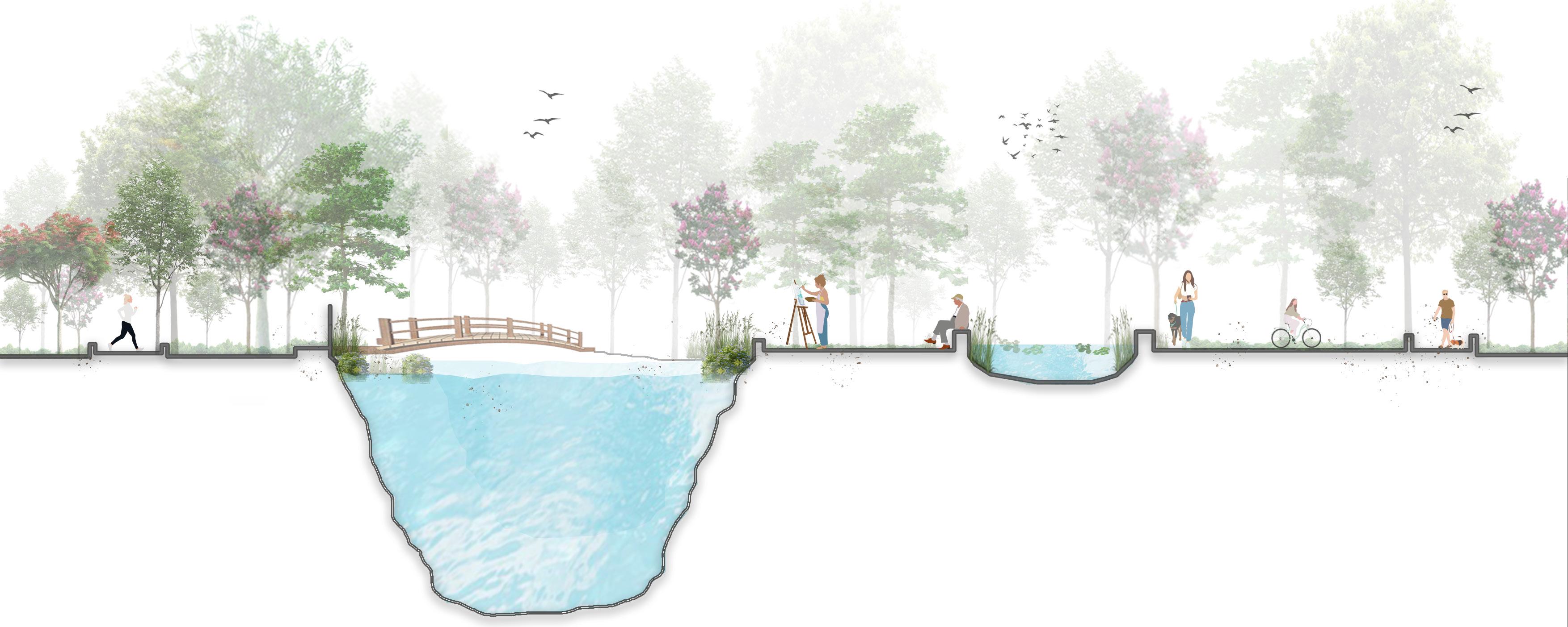 Observatory tower
Walkway
Walkway
Jogging Track
River Aire
Nature bridge
Park Retension pond
Cycle track
Play area
Observatory tower
Walkway
Walkway
Jogging Track
River Aire
Nature bridge
Park Retension pond
Cycle track
Play area


 Bird Scantury
Forest Park
Primary School
East Riddlesden Hall
Canal Park
Skywalk Park
Sensory Park
Bird Scantury
Forest Park
Primary School
East Riddlesden Hall
Canal Park
Skywalk Park
Sensory Park

Forest Park
Promenade seating area in floodplain zone
Water Sports activity
 Reedbed plantation
Retention pond
Observatory tower
Broadwalkway
Reedbed plantation
Retention pond
Observatory tower
Broadwalkway
The aim is to create a visitor hub center and manage the woodland near Butterly River. The goal is to improve the Butterly River and turn the site into a destination for nature tourism in Marsden. This can be achieved by designing the woodland in a way that connects it seamlessly with the visitor center hub, allowing visitors to enjoy a smooth transition from one place to another, thereby enhancing the overall user experience.

 Location Map
Marsden St.
Butterly Resevoir
site
Location Map
Marsden St.
Butterly Resevoir
site


0-5 Years
Upper Edgemixwoodland

Woodland mix
5-10 Years
Upper Edgemixwoodland
10-30 Years
Woodland mix
Lower edge trees and scrub mix
Riparian species
Butterly Reservoir

Lower edge trees and scrub mix

Riparian species

Butterly Reservoir
Site Section through Woodland
Master Plan - Proposed Woodland Management DesignBio-retention Parking
Proposals demonstrating how to make more of Marsden, better integrate the Mill proposal into the village, and make a place that better meets the needs of local people and visitors.

Public Park area
Activity space
Market area
Private Office area

Public Park
Multipurpose area
Office Park
Zoning diagram “Creating proactive spaces to enhance public realm and community resilience.” Weekly Market space


Legends
01. Entrance Plaza to new development
02. Space for weekly market
03. Built-in seating area
04. Lawn area
05. Lawn with seating bench
06. Cafe spillout space
07. Central space for activity & events
08. Mini Amphitheater
09. Bike spare
10. Meeting point
11. Cafe space with semi-open space
12. Parking area with strom water management
13. Waterside plantation, riparian species.
14. Installment of floating reebeds and plants


 Space for weekly market.
Open space for activity and events.
Business Park for Private office
Space for weekly market.
Open space for activity and events.
Business Park for Private office
The Concept LVIA Report of the Marsden Mill development Site & Location : Marsden, Kirklees, West Yorkshire, England
LVIA stands for Landscape and Visual Impact Assessment. Its primary purpose is to evaluate and describe how a proposed development or project might change the landscape and visual characteristics of an area. In simple terms, an LVIA report helps to understand and assess how a new building, infrastructure, or any development could affect what we see in a particular place (visual impact) and how it might change the overall look or feel of that area
The plans, for Marsden Mills proposed development are focused on rejuvenating the town center and breathing life into this significant building. The aim is to create an enhanced structure that will serve as a point, for businesses and residents. The proposal aims for partially changing the existing structure while preserving the mills facade, which holds great significance in the town's heritage.

This map shows the significant and non-significant viewpoints. Red icons are the significant ones, and the green ones are the non-significant ones. The views from the Marsden mechanics, Brougham road and from the Butterly reservoir are the significant ones and rest are the non-significant ones.

 Map showing the viewpoints significant viewpoints


Viewpoint 1 (winter view) : November 2023
Grid Reference – NW
Location : Marsden, Huddersfield
Coordinates : 53°36'06.1"N 1°55'38.9"W
The proposed viewpoint point is across from the local church and cafes, on Warehouse Hill Road, facing northwest toward the application location. Photomontage characterizes the proposed planning as consisting of both maintained and newly constructed buildings.
 Existing view of Mill from viewpoint 1
Cumulative photomontage view with proposed Redevelopment of Mill
Existing view of Mill from viewpoint 1
Cumulative photomontage view with proposed Redevelopment of Mill


Viewpoint 2 (winter view) : November 2023
Grid Reference – NW
Location : Marsden, Huddersfield
The suggested perspective location faces the Mill development plan's planned parking area from the northeast of the property. Views are taken from Mill Road, which eventually leads to Brougham Road.The parking structure's exterior design is for both residential and business units is demonstrated by the photomontage view, which is based on assumptions
 Existing view of Mill from viewpoint 2
The Villa Aangan project involved designing the layout of the pool and the interior of the rooms. The pool was located adjacent to the villa so that guests could enjoy the breathtaking views around the villa. Additionally, the pool was integrated with a play area.


01. Entry towards pool
02. Built-in seating area with pool chair
03. Shower area
04. Deck area
05. Swimming pool
06. Pool walkway
07. Bamboo screnning
08. Villa


To design a“Centre for Tranquility”, and promote the healthy lifestyle through Ayurveda and Yoga, which act as the space for wellbeing, self-sustained built environment that provokes mental and physical healing.

Proposed Master Plan

Total Site area - 30 Acres ( 121406 sq.m )
Proposed Total Built-up area -13,675 sq.m….(A)
F.S.I – 01
Total activities area – 40,230 sq.m….(B) (A+B )= 13,675+40,230= 53,905 sq.m
Proposed Master plan
1. Admininstration & Library 2. Training & Consulting Center 3. Multipurpose Area 4. Treatment Center 5. Dinning Area 6. Mud Bath with pool 7. Accomoation 8. Cowshed 3. Yoga & Meditation Center Section of Admintration building with sunken library

 Elevation of Yoga and Meditation Block


 Entrance of Adminstration and library Block
Five Elements of Nature inspired as Nature’s healing element.
Entrance of Adminstration and library Block
Entrance of Adminstration and library Block
Five Elements of Nature inspired as Nature’s healing element.
1. A new visionary approach to Shipleys road corridore and town center through urban landscape intervention.
2. Park Square planning near Rosebowl site next to Leeds beckett University.

Thought process sketch of Shipley which is development within the valley and alongside of river aire and leeds-liver pool canal.


 Bamboo Cafe Model
Bamboo Yurt-hut Model
Bamboo Yurt-hut Model
Bamboo Cafe Model
Bamboo Yurt-hut Model
Bamboo Yurt-hut Model


