
7 minute read
AERIAL HIKER


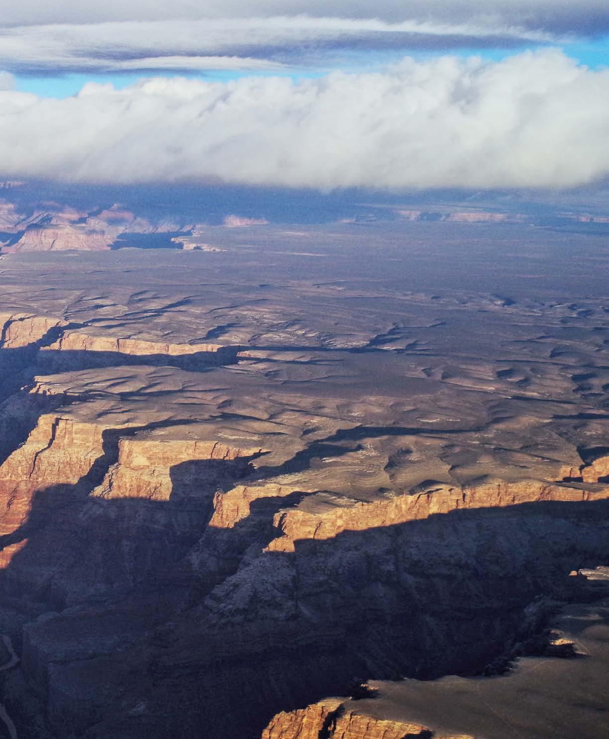
The 3,000-foot deep gorge of the Little Colorado River meeting the Colorado River in eastern Grand Canyon. photo by Bruce Grubbs
Aerial Hiker Viewing trails from the sky has a way of changing one’s perspective
Advertisement
BY BRUCE GRUBBS
GROWING UP
It took me a long time to decide what I wanted to do when I grew up. I’ve worked retail in a gear shop, spent 11 summers fighting wildland fires and owned an outdoor store. But there’s never been any doubt about hiking and backpacking — I’ve always been addicted to hiking since my teens. I’ve also been into rock climbing and mountaineering, cross-country and alpine skiing, sea and whitewater kayaking and mountain biking. But hiking is what I always come back to, no matter what.
After several career changes, I became a professional pilot. No, not driving airliners. I like little planes; so I started out, like many pilots, as a flight instructor. Instructors teach in the smallest of planes, usually two- or four-seaters. And as in so many things, I really began to learn about flying and airmanship when I started to instruct. Although I enjoyed instruction, what I ultimately wanted to do was fly charters and tours in propeller airplanes. The great thing about small planes is that they are flown low, generally under the clouds, if any exist. And so everyone has an intimate view of the landscape as it rolls past. Flying past the high mountains of northern Arizona, I can watch the winter snows recede and then watch the quaking aspen trees green up entire mountainsides. And I can watch (from a safe distance) as summer thunderstorms boil up over the mountains and flick them with lightning strikes.
HIDDEN CONTOURS
Hiking and exploring, especially off-trail and in little traveled areas, means that you get to know maps. And I’ve always liked maps — especially topographic maps that show the detail of the terrain. Just a glance at these maps shows you the steep and gentle terrain and how trails work through the landscape. Hidden contour lines on a steep slope or along a canyon bottom reveal where cliffs may block the way. And broad canyon bottoms with few contour lines hint at stream side meadows which could be magical campsites. Or maybe that flat ridge just above may be an even better campsite, with distant views.
ABOVE IT ALL
Yep, I’ve always liked the view from an airplane, above mountaintops and canyon rims. So it was pretty natural for me to work four summers on a U.S. Forest Service fire lookout. Living in a glass box on the top of a mountain gave me a unique perspective.
It was a joy to watch the seasons change. Feeling the tower shake in the blast of the spring winds was something I could have done without, but I tolerated it knowing that the breathless hot days of summer would follow. And then relief when the moist air of the monsoon started moving up from the south, putting clouds in the sky for the first time in two months, firing ››
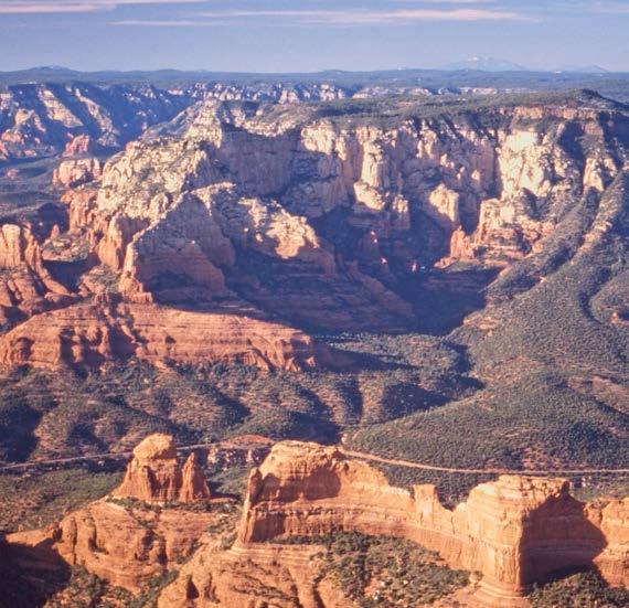
The red rocks of Sedona, looking northwest toward Wilson Mountain. photo by Bruce Grubbs
off afternoon thunderstorms that hit the tower with hail, lightning and torrential rain and starting forest fires.
Summer monsoon rains saturate and raise seasonal springs and creeks — a delight on my early morning and evening walks, when I’m off duty. By this time in the year, the days are starting to get noticeably shorter and the noontime shadows longer. And then the monsoon ends and the nip of fall is in the air, along with a few splashes of bright red from the maples turning color. Fire season is just about over, and I’ve watched the whole cycle from my mountaintop perch.
AERIAL PATROL
After a stint of instructing, I got the first of several jobs flying charters and tours. Since then, I’ve been regularly patrolling the skies of the Southwest, keeping an eye on things. Flying at low altitude, it’s very much the same perspective as the fire lookout, only constantly changing. And yes, I get to report the occasional lightning or human-caused wildfire.
I’ve watched as massive shafts of rain suddenly saturate several square miles of plateau, then see flash floods roar down canyons in a muddy froth of foam and debris. And I’ve seen 500-foot waterfalls leap over sheer cliffs as floodwaters reach the rims of deep canyons. I’ve seen the high desert turn from the seared yellow and brown of high summer into a lush green landscape dotted with small lakes, ponds and streams as an unusually wet monsoon pummeled the Southwest with storm after storm. And then, of course, I get to see mountainsides and high plateaus turn yellow, orange and red as the aspen change color in the fall, followed by the first dusting of snow on the highest peaks.
Geology really reveals its secrets to me as I fly over the stony landscape. I can see the craters atop the numerous cinder cones and volcanoes in northern Arizona, and the miles-long lava flows that once poured across the landscape. I can see where lava flows once filled and blocked canyons, forming huge lakes that have since vanished. I fly around the tower eroded cores of ancient volcanoes, now gone except for the solidified neck to the volcano where liquid rock once raced to the surface. I can trace monoclines, where rocks have been warped upward to a higher level, for 100 miles across the desert and forest. Flying over canyons, I can see the scars where recent rockfall has widened that canyon by just a little bit. I’ve even seen dust rising from rockfall that has just happened. CONNECTIONS
Not too long ago, a couple of friends and I did an 11-day hike in the far east region of Grand Canyon National Park, a section that I regularly fly over on air tours. While planning the trip, which would be almost entirely cross-country, I realized that I was visualizing the terrain as if I was flying over it. Actually, it was kind of a connected overview from the topo maps, my aerial memory and my experiences hiking in the terrain.
The trip would start with a descent off the rim down a steep ravine. We had a choice of two ravines, one facing north and one facing south. But it had been a snowy spring and it was likely that the north-facing ravine would be full of snow, while the southfacing one would be dry. However, there were a few missing contour lines in the south-facing ravine that could mean cliffs too high to navigate with our limited climbing gear.
So, the next time I flew a tour over the area, I had a good look. And I could clearly see that the small cliffs were bypassed by ledges leading to talus slopes — nothing we couldn’t work our way down, even if we had to lower packs on a rope on some of the trickier sections. And so it proved on the trip.
Another 10-day trip into the central Grand Canyon would also start with a cross-country descent down a steep slope below the North Rim. This time the problem was brush, 10-foot high chaparral with black locust mixed in for additional fun. But a quick look from the air revealed that one of the ravines draining the slope had been scoured clear of brush by recent floods and would get us through the brush zone into more open terrain below.
Of course, there’s also a peculiar trap — thinking that because I can fly over a section in a minute or two that it’ll be an easy hike! It only took me 15 minutes to fly the route of that 10-day hike.
I also really enjoy looking back at trips I’ve done as I fly over an area. There’s the ridge we dry camped with a unique midlevel view of the eastern Grand Canyon. And there’s the weird circular prehistoric structure I found deep in a desert wilderness, nearly hidden in the brush. And there’s the huge boulder that provided welcome shade on a lunch stop on a remote red rock sandstone terrace. From 3,000 feet above, I can clearly see that old prospector trail that we unexpectedly found which turned a rough finish to the day into an easy jaunt to our campsite.
And it never stops. Hmmm, I wonder if that ridge offers a way through that cliff band?
BRUCE GRUBBS has been hiking, backpacking, cross-country skiing, kayaking, mountain biking and otherwise exploring the American Southwest for several decades. He is the author of more than thirty outdoor and travel books.
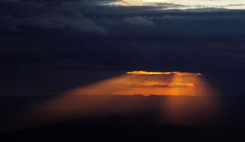
A stormy sunset on a repositioning flight to the Grand Canyon. photo by Bruce Grubbs
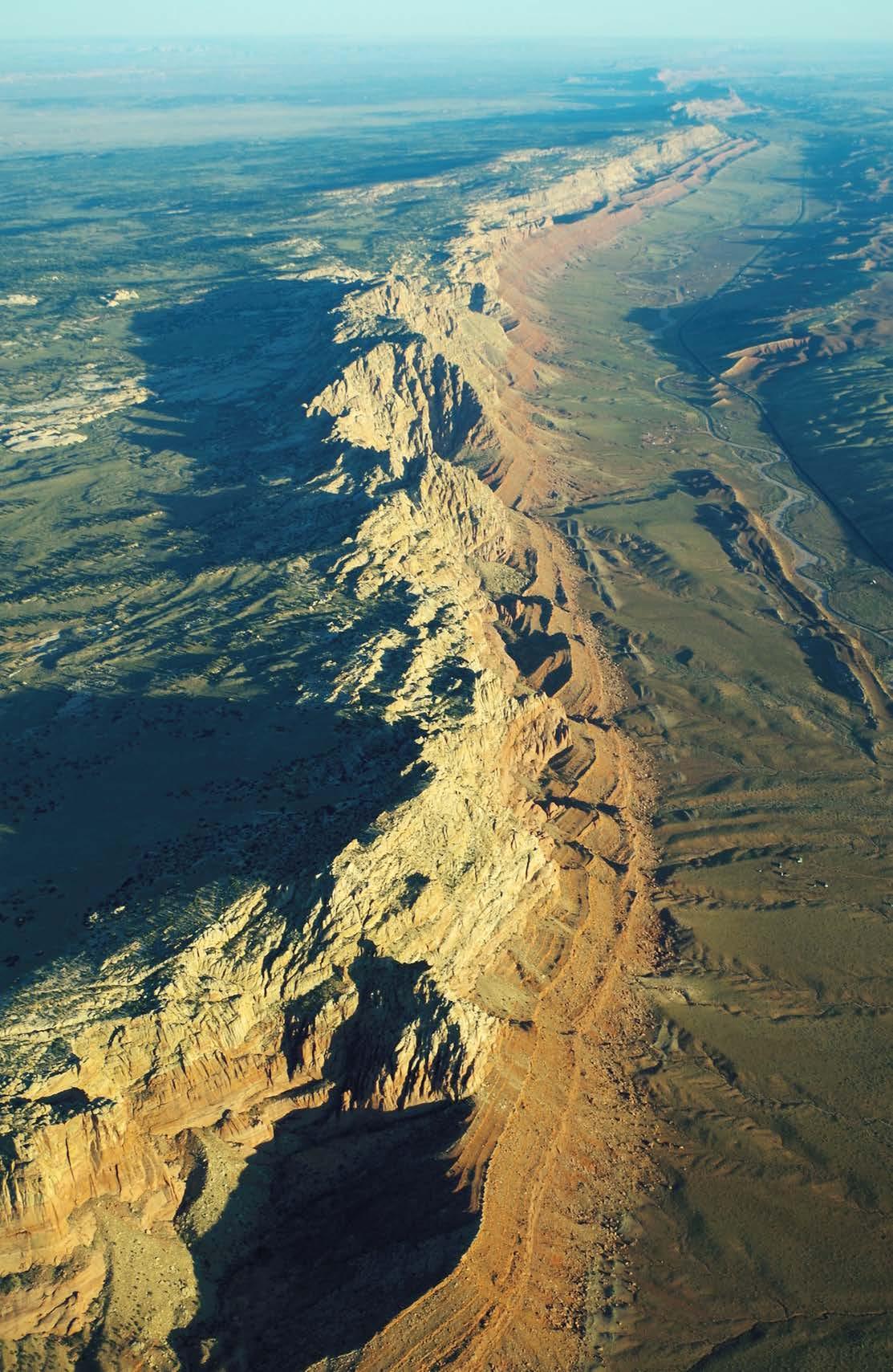
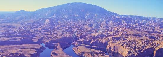
The Echo Cliffs — a monocline parallel to US 89 in northern Arizona. photo by Bruce Grubbs


