
PORTFOLIO

2022
- selected works -
PORTFOLIO
1. PROFESSIONAL PROJECTS
2. STUDENT PROJECTS
PART 1: PROFESSIONAL PROJECTS
1. Laajasalo Waterfront Development Helsinki, Finland Komitea Architects
2. Parkopelago Turku, Finland. Komitea Architects
3. Helsinki-Vantaa Airport Helsinki, Finland ALA Architects
4. Saukkolaituri Parking Facility Helsinki, Finland. ALA Architects
5. Sino-Finnish Centre Nanjing, China. ALA Architects
6. Finnish-Russian School Helsinki, Finland. ALA Architects
PART 2: STUDENT PROJECTS
7. Reconnecting Gävle's Delta. Gävle, Sweden. SLU Master’s Thesis (Landscape Architecture)
8. Wetland Square, Market Pier Kapiti, NZ. Victoria University Master’s Thesis (Architecture)
9. Productive Eco-Village Uppsala, Sweden. SLU University Urban Design Studio
10. Parabolic Dune Visitor Centre Kapiti, NZ. Victoria University Design Studio
11. Maison d'Etudiant Paris, France. Ecole Spéciale d'Architecture Master's exchange
12. Living amongst the pines. Uppsala, Sweden. SLU University Urban Ecology Studio
1| LAAJASALO WATERFRONT SITE PLAN
HELSINKI, FINLAND
EUROPAN COMPETITION 1ST PRIZE + COMMISSION Komitea Architects (Lotta Kindberg, Nea Tuominen) O riginal Competition Entry : http://europan.fi/entry/lateral-coalescence/
At the periphery of Helsinki city lies Laajasalonlahti:a sheltered bay where a 100 year-old pine forest gradually descends a slight slope before being met with the wetland rushes of the water's edge. To the east, lies Laajasalontie: a car-dominated highway dividing Yliskylä town centre and suburbs in the east from the recreation opportunities of the western Laajasalonlahti. To meet these site challenges, we formulated three key ideas: 1) to create an active public waterfront linkway with diverse edge treatment; 2) to establish a Marina Vista connection linking the boulevard to the sea; 3) to conserve and celebrate the character of the marina, forest and wetland environment. Following our competition success, we were invited by Helsinki City to develop our original proposal and formulate four design iterations.

Laajasalon pohjoisosan asemakaavan muutosalueen ideasuunnitelma KOMITEA ARKKITEHDIT 23.05.2019 VE 2B RAKEISUUS 1:4000 työvaihe LUONNOS 1:5000 19.05.2019 ETRS-GK25 N2000 RAKEISUUS TARKASTELU VE 2B JATKETTU RANTA P 0 50 100 150 200
Yliskylä Bay Helsinki City 5km Town Centre

 Laajasalon pohjoisosan asemakaavan muutosalueen ideasuunnitelma KOMITEA ARKKITEHDIT
23.05.2019
MARINA VISTA
Laajasalon pohjoisosan asemakaavan muutosalueen ideasuunnitelma KOMITEA ARKKITEHDIT
23.05.2019
MARINA VISTA
Option 2B: Extended Shoreline B (Preferred option)

The shoreline is infilled to allow the creation of 3 blocks to the north of Marina Vista. A carpark building and supermarket are incorporated in the south. A distinctive waterfront condition is established celebrating the existing wetland character, with an elevated pedestrian bridge linking a public jetty and seating platform to the wetland pathways and forest.

pysäkki (+3.3) +6.8 +4.8 +6.0 PIENVENESATAMA / VENEIDEN TALVISÄILYTYS SUISTO +6.3 +6.5 vihertasku +6.5 +4.5 +3.3 +10.0 +6.8 +6.5 päiväkoti huolto (+3.3) +6.8 (+3.3) +6.8 II I I VII II V V VI II V +4.8 2400 k-m2 tontti 5150 m2 metsäpiha satamapaviljonki HOP ON, HOP OFF +3.3 kajakkikerho +1.3 II VI III VII IV III V IX VII III X II VII VII VI II II XIV VIII VII IX VI II III +4.5 silta hulevesipuutarha +3.3 +2.0 +1.3 +1.3 sauna meriallas C C V 288 ap (228 ap asukkaille 60 ap kaupalle) saatto/pysäköinti VII II vieraspysäköinti12ap vieraspysäköinti 5 ap vieraspysäköinti6apvieraspysäköinti5ap pysäkki pysäkki satamanpysäköinti30ap +2.0 asiakaspys. 3 ap IX V VI KORTTELI1 12190 k-m² map 94 ap II VIII VII VII IV VI V VI KORTTELI 2 9880 k-m² map 76 ap KORTTELI 3 12985 k-m² (100 ap p-talossa) KORTTELI 5 16585 k-m² (128 ap p-talossa) KORTTELI 4 11350 k-m² map 88 ap vieraspysäköinti9ap asiakaspys. 5 ap veneiden a lasku nosto ajo parkkihalliin ajo parkkihalliin ajo parkkihalliin ajo parkkihalliin Parkkitalo kongi la ket (l 1800 k-m² a alon parkki asuinrakennuksen maantasossa) (liiketilaakatutasossa) (liiketilaakatutasossa) (liiketilaakatutasossa) (liiketilaakatutasossa) (liiketilaakatutasossa) (liiketilaa katutasossa) (liiketilaa katutasossa) (liiketilaa katutasossa) työvaihe LUONNOS mittakaava 1:1500 päivämäärä 19.05.2019 tasokoordinaatisto ETRS-GK25 korkeusjärjestelmä N2000 sisältö ASEMAPIIRUSTUS VE 2B NIEMI P 0 20 40 60 80 100 VE 2B ASEMAPIIRROS
Laajasalon pohjoisosan asemakaavan muutosalueen ideasuunnitelma KOMITEA ARKKITEHDIT 23.05.2019 KERROSALALASKELMAT
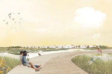
2| PARKOPELAGO
TURKU HARBOUR, FINLAND
OPEN COMPETITION 2020
Komitea Architects (Nea Tuominen, Lotta Kindberg)
Our vision is for a distinctive urban waterfront that projects the city’s rich maritime history, its contemporary urban culture and its unique marine archipelago environment. Our proposal establishes a distinctive and varied coastline featuring a ‘Museum Spine’, its own ‘Parkopelago’, ‘Port Village’, a developed ‘Maritime Square’ and a coastal promenade linking the site together.
KEY DESIGN MOVES
1. Increasing the edge: With the port occupying the west side, Parkopelago seeks a connection with the sea to the south. The shoreline is pulled back towards the castle and the former port is transformed into a new archipelago wetland biodiversity zone. The shore edge hosts the new Local Ferry Harbour, Archipelago Centre and also the Museum of History and Future.
Project Involvement:
Design Team Leader. Responsible for leading key design decisions, coallating the final panels, and producing the renderings, diagrams and the 1:2000 Site Plan.
2. Open shoreline and walkability: The new waterfront area prioritises the pedestrian experience. ‘Archipelago Axis’ and ‘Castle Vista’ are established to promote views towards the sea and castle respectively.

3. Diverse activities year-round: The ‘Museum Spine’ strategy supported by the Port Village, Craft Beer Garden and Culture Factory buildings encourages activity even on Turku’s coldest winter days. In the summer, the park is at full-capacity, hosting weddings in the old Seaport Hotel, and outdoor concerts on the festival lawn.
The design weaves together existing cultural and natural historical layers of the site, inserting new and diverse outdoor recreation spaces, well-placed contemporary public buildings, and sustainable water-sensitive design.
An open walkable coastline...


...with viewpoints to the archipelago
...and views back to the castle
A new edge connects city and sea... forming an active and open waterfront...

with new and old buildings scattered....

with new and old buildings scattered....
with views to the archipelago & river... and views back towards the castle...
...to activate an URBAN PARK.

where old and new mix together.... the castle becomes the heart of a new Museum Spine in Linnanniemi...


to activate a Living Heritage Nature Park.... connecting Turku city to the archipelago


CITY CONNECTED TO THE SEA

1. Port Hotel 2. Market and Port Village 3. Hockey Rink/ Stormwater retention basin 4. Beer Garden 5. Culture Factory 6. Boutique Cinema 7. Turku Baana 8. Forum Marinum + Canopy Extension 1 2 3 9 10 11

9.
12.
13.
14.
4 5 6 7 8 12 13 15 14
Port Museum
10.
Seaport Events Centre
11.
Rainwater Filtration Network
Museum of History & Future
Wetland Archipelago
Castle Vista
15.
Archipelago Visitor Centre
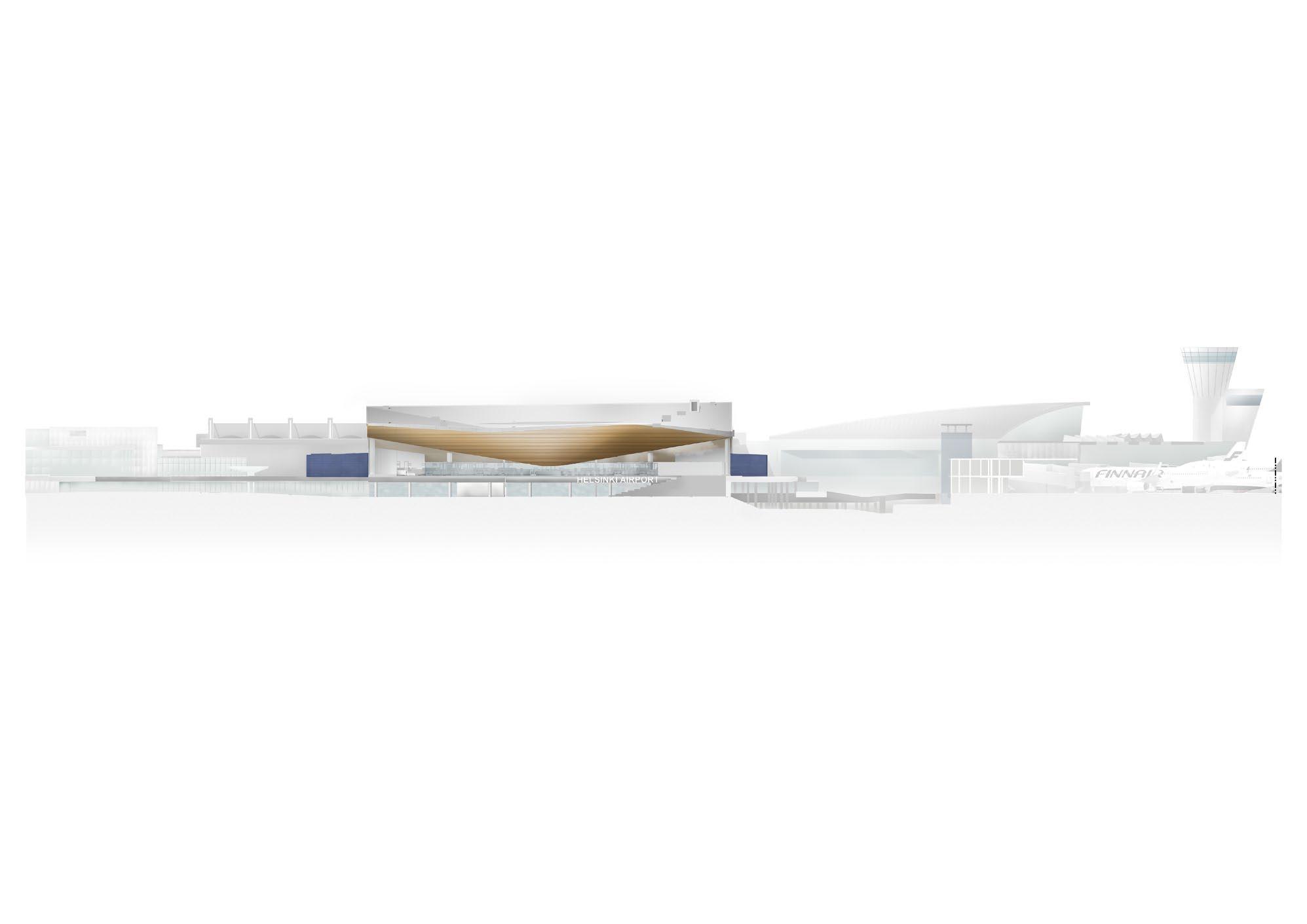
3| HELSINKI-VANTAA AIRPORT EXTENSION

VANTAA, FINLAND
INVITED COMPETITION 1ST PRIZE (2017) + COMMISSION (Completed 2021). ALA Architects
The terminal expansion, mentally linking Finland with the World, comprises two building volumes: “City Hall” and “Security Box”. “City Hall” houses the departure and arrivals halls, and the blue “Security Box” the security check and baggage claim areas. The aim is to simplify the airport structure in such a way that the passenger will recognize both the entrance and the whole process from arriving to the terminal to boarding a plane at a glance.
Project Involvement: Competition phase: exploded axonometric and elevation drawings. Development and Implementation phases: coordination of presentation packages, preparing design studies and visualisations, design tests (bathrooms, railings, bus shelter, baggage arrivals space), working drawings of the ceilings, stairs, and walls.
 Photo: Tuomas Uusheimo


JULKISIVUOTE 1

 Arrivals hall and the blue "security box". Photo: Tuomas Uusheimo
Departures hall. Photo: Tuomas Uusheimo
Arrivals hall and the blue "security box". Photo: Tuomas Uusheimo
Departures hall. Photo: Tuomas Uusheimo
Exploded Axonometric
Proposed circulation - competition phase

4| SAUKONLAITURI PARKING FACILITY

HELSINKI, FINLAND
COMMISSION. 2016-2019 (Completed) ALA Architects
The new Saukonlaituri parking garage is situated in the vacated old cargo port and dock yard area in Jätkäsaari, right by downtown Helsinki. The area will house 17,000 people and workplaces for another 6,000. Since the underground construction of parking below sea level would be too expensive, the city is developing a series of architecturally ambitious above ground parking facilities for the area.
The new Saukonlaituri parking garage consists of six circuits of parking around a central courtyard forming a light well. The southern side of the building is designed using a series of planted 'switchbacks', allowing residents to hike up to their cars across the sand and seaside grassed terraces/ roofs. The facade is made of burnt clay bars in varying hues of natural sand.
Project Involvement: Concept studies, early massing (both digital and analogue modelling)). Facade development involving digital modelling and visualisations. Elevation drawings.


 Photos: Marc Goodwin, Tuomas Uusheimo
5| SINO-FINNISH CULTURAL CENTRE NANJING, CHINA
INVITED COMPETITION - 2ND PRIZE (2016) ALA Architects
The Sino-Finnish Center represents cooperation between China and Finland in the fields of investment, economic trade, environmental sustainability, cultural tourism and social science research. ALA’s proposal represents an ecologically sustainable way of building cities. The key concept in the design is to think about the ecological impact of the entire life cycle of the development from pre-planning to demolition and recycling.
The design site is divided into two distinctive areas: a high-density, green-roofed hybrid city block utilising the best clean tech solutions available, and a purified, publicly accessible wetland park.
The wetland park, inspired by Finland’s landscape, acts as a contrast and complement to the urban block. The park will be used as a demonstration area for clean technologies, and will contain a network of small pavilions linked by a system of wooden piers. The park area also plays an important role in managing the rainwater overflow, and negotiating the impact of the large urban block.
Project Involvement:
Site plan and diagrams, coordinating with the landscape architects to design the wetland park, inner courtyard and overall traffic plan scheme.


Design Concept 绿色科技时间线的原型街区 “CLEAN TECH TIMELINE PROTOTYPE BLOCK” ALA 建筑事务所 ALA ARCHITECTS rooftop of called ravine. are ecosystem small surplus from The which the small. will sustainable CLEAN STORMWATER FROM THE ROOF GREEN ROOF, STORMWATER DETENTION, COOLING DOWN THE BUILDING, BETTER MICRO CLIMATE WETLANDS/ BOG WETLANDS/ BOG FOREST, BIOFILTRATION FOR STORMWATER FROM STREETS FOREST, BIOFILTRATION FOR STORMWATER FROM STREETS WATER RESERVOIR LAKE FLOOD ZONE 森林︐过滤从街道收集的雨水 森林︐过滤从街道收集的雨水 绿色屋顶︐雨水收集 室内制冷 更好的室内微环境 沼泽湿地︐雨水储藏 沼泽湿地 蓄水池 浸水区域 从屋顶收集的干净雨水 8 中芬经济文化合作交流中心概念方案设计 Sino- Finnish Econimic, Trade and Cultural Cooperation and Exchange Center Schematic Design Concept 建筑区域被定义为一个高密度的城市街区 Built area is defind as dense urban block 功能块根据互相之间的联系与周边环境的关系设置在街区的 不同地方 Programs are located interact with their 158 m 158 m Programme organised as dense urban block Finnish urban block and Finnish lake Building and park work together to collect and filter rainwater. AERIAL Image: Vizarch
6| FINNISH-RUSSIAN SCHOOL
HELSINKI, FINLAND
INVITED COMPETITION - HONOURABLE MENTION 2018 ALA Architects

The site for the Finnish Russian School in suburban Helsinki deals with challenging traffic noise from the adjacent highway, positioning the new school building and the possible new sports hall in an ‘L’ shape to create a clearly defined multifunctional yard area that protects the students from both noise and pollution.


KAUPUNKISUUNNITTELUTASON RATKAISU JA
Uusi Suomalais-venäläinen koulu asettuu koulun vanhalle tontille, jonka ympä ristö on vuosien saatossa muuttunut liikenteen kuormittamaksi erityisesti äänen ja melun osalta. Toimivalle kouluyhteisölle tärkeän ulkotilan muokkaaminen on massa ja huomattavan kokoinen liikuntasalin varaus asettuvat tontille reunus taen selkeän ja monikäyttöisen, ääneltä ja ilmansaasteilta suojatun piha-alueen. Rakennukset sijoittuvat kahdelle eri tontille omiksi hankkeikseen siten, että niiden väliin syntyy uusi urbaani kaupunkitila, julkinen kuja, joka jatkaa Hä meenlinnantien alittavan kevyenliikenteenväylän reitin tontin halki. Liikun tahalli sijoittuu tontin eteläisen metsikön rajaamaksi, selkeäksi ja hillityksi hankkeeksi, jolla on oma pysäköintialue ja omat yhteydet ympäröivään liiken neverkkoon ja kunnallistekniikkaan. Tämä mahdollistaa koulu- ja liikuntahank keiden toisistaan riippumattoman vaiheistuksen, toteutuksen ja hallinnoinnin. Uusi koulurakennus sijoittuu tontin länsireunaan pitkänä ja selkeänä massana. Koulun läntinen julkisivu on akustisesti ja visuaalisesti ympäristöä rajaava kak soisjulkisivu, jonka sisällä viljellään pystysuuntaista opetuspuutarhaa. Tämän kas villisuuden läpi suodattuva valo sekä kasvien elo vuodenaikojen halki muodosta vat moottoritie- ja melumuurimaiseman tilalle kiehtovan näkymän myös länteen. Koulun avautuu ympäristöönsä toiminnallisesti kaikilta sivuiltaan. Huoltoliiken ne sijoittuu kompaktisti länsisivulle. Pohjoispäästään rakennus seuraa tontin ra jaa maksimoiden äänisuojan pihalle. Pienimpien lasten sisäänkäynnit sijaitsevat itäsivun pohjoispäässä lähinnä saattoliikennevyöhykettä. Koko itäsivu avautuu pihalle useamman sisäänkäynnin ja avonaisen puu- ja lasirakenteisen julkisivun läpi. Eteläjulkisivu avautuu uudelle kujalle, jonka yli rakennetaan siltayhteys lii kuntahalliin. Rakennuksen kauniisti ja selkeästi taitteileva katto muodostaa sar jan säältä ja melulta suojattuja ulkotiloja rakennuksen äärelle.
The interior planning concept is based upon community: the central plaza acts as the heart where students come together, dine, study and hang out. Around the plaza, the building is divided into different zones according to age groups, and classrooms are situated around a mini square. Various rooms and areas can be closed off or joined together enabling both active, multifunctional but also private and quiet spaces as necessary.
Project Involvement:
MELUNTORJUNTA Koulun ja liikuntahallin muodostama asetel ma suojaa pihaa melulta ja ilmansaasteilta.
SAAVUTETTAVUUS JA YHTEYDET Koulu on hyvin saavutettavissa tontin eri puolilta. Kevyen- ja autoliikenteen reitit on erotettu toisistaan.
Liikuntahalli
Kauppakeskuseen
Team Leader. Responsibilities included initial site studies, facade design, site plan, concept and axonometric diagrams, coordinating with the external visualisation company, assembling the final presentation panels and overseeing the quality of all presentation images.
Site Plan
1:500
MATERIAALIT JA TEKNISET RATKAISUT
Rakennus suunnitellaan kestäväksi ja terveelliseksi kouluksi, jonka ylläpito on helppoa ja kustannustehokasta koko sen elinkaaren ajan. Joustava pilari-palk ki-laatta -runko verhotaan puurakenteisilla ulkoseinä- ja yläpohjaelementeillä. Julkisivuverhouksena käytetään säänkestävää palosuojattua puuta ja rautaoksidi tonta lasia. Kattomateriaalina on konesaumattu sinkkikate kermikatteen päällä. Rakennus toteutetaan lähes nollaenergiatalona hyödyntäen tehokkaasti luonnon valoa julkisivujen ja pystysuorien, vuotoriskittömien kattoikkunoiden kautta, sekä tehokasta koneellisen ilmanvaihdon lämmän talteenottoa. Julkisivut ovat tehokkaasti eristettyjä, terveitä rakenteita, jotka myös leikkaavat lämpösäteilyä merkittävästi vähentäen jäähdytystarvetta.
Asemapiirros
- MESTA -
“MESTA” SUOMALAIS-VENÄLÄISEN KOULUN UUDISRAKENNUS 1/6
TONTIN JAKAMINEN Tontti jakautuu selkeästi koulun ja liikunta hallin osaan. Tontti mukautuu siten tulevai suuden eri kehitystarpeisiin.
Pohjapiirustus 2.krs 1:200
uusi
väliin
pihalle useamman sisäänkäynnin ja avonaisen puu- ja lasirakenteisen julkisivun läpi. Eteläjulkisivu avautuu uudelle kujalle, jonka yli rakennetaan siltayhteys lii kuntahalliin. Rakennuksen kauniisti ja selkeästi taitteileva katto muodostaa sar jan säältä ja melulta suojattuja ulkotiloja rakennuksen äärelle.
MELUNTORJUNTA
Koulun ja liikuntahallin muodostama asetel ma suojaa pihaa melulta ja ilmansaasteilta.
MELUNTORJUNTA
NOISE BARRIER
Piha
SAAVUTETTAVUUS JA YHTEYDET Koulu on hyvin saavutettavissa tontin eri puolilta. Kevyen- ja autoliikenteen reitit on erotettu toisistaan.
Koulun ja liikuntahallin muodostama asetel ma suojaa pihaa melulta ja ilmansaasteilta.
kaupunkitila, julkinen kuja, joka jatkaa Hä meenlinnantien alittavan kevyenliikenteenväylän reitin tontin halki. Liikun tahalli sijoittuu tontin eteläisen metsikön rajaamaksi, selkeäksi ja hillityksi hankkeeksi, jolla on oma pysäköintialue ja omat yhteydet ympäröivään liiken neverkkoon ja kunnallistekniikkaan. Tämä mahdollistaa koulu- ja liikuntahank keiden toisistaan riippumattoman vaiheistuksen, toteutuksen ja hallinnoinnin. Uusi koulurakennus sijoittuu tontin länsireunaan pitkänä ja selkeänä massana. Koulun läntinen julkisivu on akustisesti ja visuaalisesti ympäristöä rajaava kak soisjulkisivu, jonka sisällä viljellään pystysuuntaista opetuspuutarhaa. Tämän kas villisuuden läpi suodattuva valo sekä kasvien elo vuodenaikojen halki muodosta vat moottoritie- ja melumuurimaiseman tilalle kiehtovan näkymän myös länteen. Koulun avautuu ympäristöönsä toiminnallisesti kaikilta sivuiltaan. Huoltoliiken ne sijoittuu kompaktisti länsisivulle. Pohjoispäästään rakennus seuraa tontin ra jaa maksimoiden äänisuojan pihalle. Pienimpien lasten sisäänkäynnit sijaitsevat itäsivun pohjoispäässä lähinnä saattoliikennevyöhykettä. Koko itäsivu avautuu pihalle useamman sisäänkäynnin ja avonaisen puu- ja lasirakenteisen julkisivun läpi. Eteläjulkisivu avautuu uudelle kujalle, jonka yli rakennetaan siltayhteys lii kuntahalliin. Rakennuksen kauniisti ja selkeästi taitteileva katto muodostaa sar jan säältä ja melulta suojattuja ulkotiloja rakennuksen äärelle.
SAAVUTETTAVUUS JA YHTEYDET Koulu on hyvin saavutettavissa tontin eri puolilta. Kevyen- ja autoliikenteen reitit on erotettu toisistaan.
TONTIN JAKAMINEN
Liikuntasalle
The ‘L’ positioning of the buildings creates a courtyard protected from street noise and pollution

PLOT ALLOCATION
Liikuntasalle
Bussi
Koulu Koulu Liikuntahalli Liikuntahalli
Tontti jakautuu selkeästi koulun ja liikunta hallin osaan. Tontti mukautuu siten tulevai suuden eri kehitystarpeisiin.
Kauppakeskuseen
Bussi Bussi
MELUNTORJUNTA Koulun ja liikuntahallin muodostama asetel ma suojaa pihaa melulta ja ilmansaasteilta.
TONTIN JAKAMINENSAAVUTETTAVUUS JA YHTEYDET Koulu on hyvin saavutettavissa tontin eri puolilta. Kevyen- ja autoliikenteen reitit on erotettu toisistaan.
JAKAMINEN
TONTIN
Tontti jakautuu selkeästi koulun ja liikunta hallin osaan. Tontti mukautuu siten tulevai suuden eri kehitystarpeisiin.
The plot is divided into 2 parts: the school and the sports hall. The site can adapt to the development needs of the future.


ACCESS + CONNECTIONS
The buildings and entries are positioned to connect to public transport links.
KESKUSTORI
KESKUSTORI
Keskustori jatkuu Keskustoria kiertää vän aikana kerääntyä erilaisia tapahtumia jat voivat hakeutua enemmän yksityisyyttä. kuinen viherseinä, yhteydessä mahdollisuuden
OPETUKSEN JA
Opetuksen ja hallinnon seen kerroksen mahdollistaen tumisen, ja tarjoten Yksittäiset työtilat toyksiköiksi. Tilojen sekä opiskelijoiden
KOTIALUE 2
SUOMALAIS-VENÄLÄISEN
Keskustori on koulurakennuksen sydän ja keskeisen kohtaamispaikka, joka ku hisee elämää aamusta iltaan. Opiskelijat kokoontuvat arkipäivisin keskustorille ruokailemaan, opiskelemaan, rentoutumaan sekä harjoittelemaan erilaisia esi tyksiä. Iltaisin ja viikonloppuisin keskustori muuntautuu teatteriksi, seminaa ritilaksi ja muuksi tapahtuma-alueeksi.
Kotialue 2 sijaitsee myös oma porrasyhteys sekä monitoimitilan 2:n tilat kiertyvät tilakokonaisuuden. ratkaisujen sekä verhojen nempiin. Myös kalustus tarkoituksia. Kotialue opiskella kylvämistä tila toimii ulko-opiskelutilana
A CENTRAL HEART SPACE GROUPS
Alueen katsomo, oppimisportaat ja parvi muodostavat teatteritilan maksimis saan noin 250 hengen esityksille. Teatteri mahdollistaa koulun erilaisten poikki tieteellisten ja -taiteellisten produktioiden esittämisen sekä vierailevien ryhmien esiintymisen tilassa, esimerkkinä esimerkiksi erilaiset ooppera-, tanssi- tai teatte riproduktiot. Tila äänieristetään esityksiä varten siirrettävien akustisten panee lien avulla. Esirippu, lavasteet ja muu esitystekniikka valoineen piiloutuvat ka ton rakenteisiin ja ovat helposti laskettavissa lavalle vastaamaan erilaisia tarpeita. Keskustorin yhteydessä sijaitsee venäjän kielen keskus kirjastoineen ja monitoimitiloineen. Tilat avautuvat tarvittaessa kokonaan keskustoril le, jolloin vuorovaikutusmahdollisuudet opiskelijoiden ja tilan eri käyt tötarkoitusten välillä pystytään maksimoimaan. Oppimisportaiden alle muodostuu intiimimpää ja rauhallisempaa tilaa, ”luola” on paik ka, johon opiskelijat voivat vetäytyä kaivatessaan enemmän yksityisyyttä. Kaikki rakennuksen eri tilaryhmät muodostavat visuaalisen yhteyden keskus toriin.
TILARYHMIEN VÄLISET SUHTEET Koulu jakaantuu pituussuunnassa kolmeen toiminnalliseen osaan. Nuorten javanhem pien opiskelijoiden tilaryhmät on sijoitettu päällekäin.
KOTIALUE 3 -
Luonnontieteen ja to- ja taideaineiden muunneltaviin laboratoriotiloihin, sekä varsinaiseen, ta tukevat kalusteet opiskelua. LUMO-tori tiloihin. Humanististen mahdollistaen aineiden
KOTIALUE 3Humanististen aineiden roksessa eli rakennuksen ti yhteydessä alempiin että valokuilun kautta man ympäristön tumaan tai tekemään opetustilojen tavoin seinät sekä erilaiset vuuden eri tilanteiden tiloja tarpeen mukaan
Pohjapiirustus 3.krs 1:200
Keskustori teatterina 1.krs 1:200
Piha P P P
Bussi Bussi
Koulu Koulu Liikuntahalli Liikuntahalli Piha P P P P
Bussi Bussi Bussi Koulu Koulu Liikuntahalli Liikuntahalli
P P
Koulu
Liikuntasalle
Kauppakeskuseen
Bussi
Kauppakeskuseen
Liikuntasalle Piha
P Bussi
Liikuntahalli
P
Bussi
Koulu
SUOMALAIS-VENÄLÄISEN
Piha P P
P Kauppakeskuseen Bussi
Bussi Koulu
Liikuntahalli Liikuntahalli
P P P P Kauppakeskuseen Bussi Bussi Bussi Koulu Koulu Liikuntahalli Liikuntahalli
Piha P P P P
P
P
Bussi Bussi
Piha P P
P
Bussi Bussi Bussi Koulu Koulu Liikuntahalli Liikuntahalli Liikuntasalle Piha P P P P Kauppakeskuseen Bussi Bussi Bussi Koulu Koulu Liikuntahalli Liikuntahalli Liikuntasalle
Piha
P
Kauppakeskuseen
Bussi Koulu Koulu Liikuntahalli Liikuntahalli
P
Kauppakeskuseen
niiden
syntyy
urbaani
SUOMALAIS-VENÄLÄISEN
P P P
- MESTA -
K3
K3
K1
TAIDE K3 LUMO
HUKI K2
KESKUSTORI KOULUN SYDÄMENÄ Keskustori eli ”Teatteri” toimii koulun oppi mis-, kokoontumis- ja tapaamispaikkana.
PORTFOLIO RACHEL MURRAY
1. PROFESSIONAL PROJECTS
2. STUDENT PROJECTS
PART 1: PROFESSIONAL PROJECTS
1. Laajasalo Waterfront Development. Helsinki, Finland Komitea Architects
2. Parkopelago. Turku, Finland. Komitea Architects
3. Helsinki-Vantaa Airport. Helsinki, Finland ALA Architects
4. Saukkolaituri Parking Facility. Helsinki, Finland. ALA Architects
5. Sino-Finnish Centre. Nanjing, China. ALA Architects
6. Finnish-Russian School. Helsinki, Finland. ALA Architects
PART 2: STUDENT PROJECTS
7. Reconnecting Gävle's Delta. Gävle, Sweden. SLU Master’s Thesis (Landscape Architecture)
8. Wetland Square, Market Pier Kapiti, NZ. Victoria University Master’s Thesis (Architecture)
9. Productive Eco-Village Uppsala, Sweden. SLU University Urban Design Studio
10. Parabolic Dune Visitor Centre Kapiti, NZ. Victoria University Design Studio
11. Maison d'Etudiant Paris, France. Ecole Spéciale d'Architecture Master's Exchange
12. Living amongst the pines. Uppsala, Sweden. SLU University Urban Ecology Studio
RECONNECTING GÄVLE'S DELTA
A Post-Industrial Transformation Project for Sweden's Coastal Landscape
GÄVLE, SWEDEN
M.Sc. Landscape Architecture Masters Thesis Project 2022 S wedish University of Agricultural Sciences
Faced with urban growth, deindustrialisation and a threatened delta landscape, Reconnecting Gävle’s Delta is a design proposal which draws on Blue-Green Infrastructure principles, and ideas of the ‘productive city’ to imagine a new flood-resilient mixed-use district at Näringen. First, a new water channel island is proposed to deal with future sea level rise by preventatively ‘inviting the water’, resulting in the creation of a new recreation 'Delta Island' for the city. Second, a network of multifunctional blue-green corridors mitigates against cloudburst flooding while providing a focal point around which new mixed-use neighbourhoods can be designed.
Challenges for Näringen, Gävle
Objectives and Strategies

7|
Gävle is flooding Näringen is vulnerable to future sea level rise
Gävle is flooding
Näringen is vulnerable to flooding from cloudburst events
PROPOSED


A climate-adapted coastal flood-resilient delta A new water channel 'invites the water'
Gävle is disconnected Poor access between city and delta reserve
A climate-adapted cloudburst-resilient delta Swale parks lead rain water to the sea
Gävle is growing / deindustrialising
Monofunctional industrial area offers growth opportunities
An accessible, connected delta Swales dually connect people to the delta
A dense, diverse, mixed-use delta Industry, housing, offices and community co-exist
EXISTING SITUATION:
A delapidated urban condition disconnected from its delta landscape
Currently, the two sides of the Testeboåns river embody two very different conditions: on one side, the industrial development at Näringen, dominated by a vast swathe of impermeable concrete, contributes to the district’s flooding problems. On the other side of the delta lies Testeboåns Delta nature reserve, a protected wetland area indicative of how Näringen would have also looked prior to its development.
 Centrum
PROPOSED VISION:
A reconnected delta landscape supports sustainable, resilient, interconnected urban and ecological communities.
The project identifies an opportunity for the redevelopment of Näringen to remediate and restore the historic Testeboåns delta landscape. By removing borders and reframing the Näringen project area alongside the nature reserve area, the design makes a clear statement: Näringen is part of a wider delta landscape ecosystem all of which must be collectively addressed as part of an interconnected social-ecological system

TESTEBOÅNS DELTA
NÄRINGEN NATURE RESERVE DELTA ISLAND


Summer, Dry

beach paddle pond Testeboåns Inlet tennis courts soccer field preserved forest coastal wetland walk summer pavilion swale swale swale forest walk industrial folly industrial folly
EAST NÄRINGEN Summer, Cloudburst Event!
8| WETLAND SQUARE, MARKET PIER
Rethinking
Heritage
in
the New Zealand Regional Landscape KAPITI, NZ
Master of Architecture [Prof] Thesis. Victoria University of Wellington.

New Zealand Institute of Architects Student Design Awards Finalist 2015 Published in ‘Interstices’ Journal of Architecture and Related Arts 17. 2016
In just a century and a half, we have destroyed 90% of New Zealand's fragile lowland wetlands. Drained and cleared, indigenous swamp forests have been converted to carpets of farming pastures and low-density urban sprawl. Along the Kapiti Coast, a new major expressway presents further challenges: a segregated beach community, continued wetland eradication and projected growth in the wake of an improved connection to Wellington City. These problems are at once ecological and urban, presenting an opportunity for design-led research to explore the potential for alternative urban settlement strategies in the regional landscape.
The design project identifies a squared-off suburban conservation wetland, transforming it into a new town square: a civic heart and symbol of the region's natural and cultural heritage. A market pier extends from the urban edge of the town square towards the central lagoon. The pier, upon which an open-air market is proposed, connects the new urban centre with the wider agricultural activity of Kapiti while reinstating the historic functions and cultural significance of the wetlands which indigenous Maori historically navigated by canoe in search of food and resources.
An agricultural hinterland
KAPITIPROPOSED SH1 WAIKANAE WAIKANAE BEACH Proposed Market Square WAIKANAE Existing Town Centre The City TUTEREST
WELLINGTON
“The plains that had been the larder of Maori life had become the centerpiece of the attempt to replicate rural Britain in the South Pacific.”Nga Uruora: The Groves of Life - Geoff Park
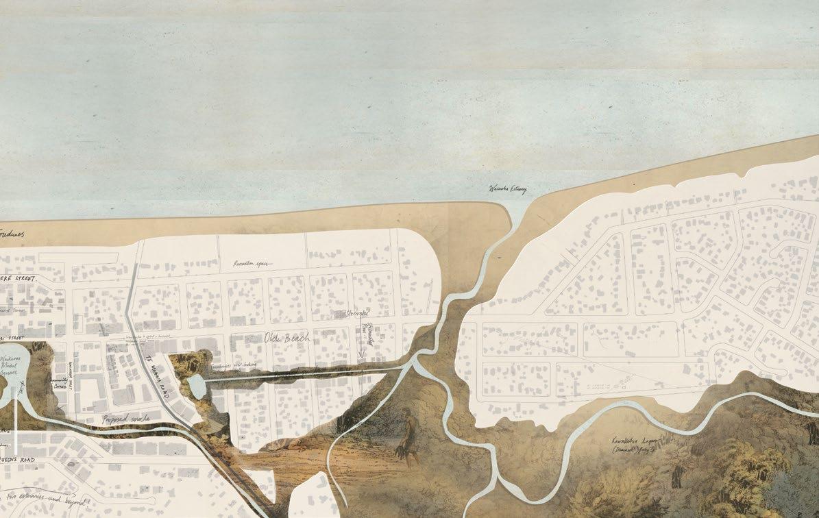


WELLINGTON PROPOSED SH1 WAIKANAE WAIKANAE BEACH Proposed Market Square WAIKANAE Existing Town Centre The City QUEENST TUTEREST PROPOSED SH1 WAIKANAE WAIKANAE BEACH Proposed Market Square Existing Town Centre QUEENST TUTEREST KAPITI WAIKANAE WAIKANAE BEACH QUEENST TUTEREST SITE: Queens Road, Waikanae Beach, Kapiti SITE PLAN CONCEPT: A wetland market square A suburban divide A degrading wetland ecoystem A “conservation” wetland The edge of a remnant lagoon is transformed into a new Market Square: a framework for medium-density housing and the civic heart of the region’s natural heritage. A WETLAND
SQUARE:
A MARKET PIER:
The wetland square plays host to a 'market pier', which transforms into a Farmer’s Market, connecting the new urban centre to Kapiti’s wider agricultural network. The market pier reinstates the historic significance of the wetlands from which indigenous Maori once sourced food and resources.

Market platform alongside the wetland

A TOWN SQUARE housing + density 1.0 How to create a new model for Urban Density? Kaitiakitanga A REVIVED WETLAND 2.0 How to revive, protect and capitilise upon an existing fragile yet productive ecology? transport AN URBAN / LANDSCAPE PROMENADE 3.0 How to offer increased accessibility to town amenities to improve community vitality + resilience?


transport AN URBAN / LANDSCAPE PROMENADE 3.0 How to offer increased accessibility to town amenities to improve community vitality + resilience? 4.0 recreation A LAGOON PIER How to connect the urban perimeter with the vast landscape? food + resources A REGIONAL MARKET How to connect Kapiti with its agricultural context and the historical place of resources it once was?
Kayak storage at water’s edge
ABOVE: A ramp leads users up to the upper rooftop viewing deck OPPOSITE: Proposed regional framework concept showing 3 wetlands linked by their waterways

A REGIONAL WETLAND NETWORK
Together, the Market Square and Wetland Pier operated as an archetype, responding to other ‘grid-locked’ remnant wetlands - a system for wetland-orientated urban intensification and the restoration of a regional wetland network.

The research rethinks land conservation practice in New Zealand's settled regional landscapes. It advocates that conservation efforts should expand beyond current land protection measures to also consider preserving the historic relationship between early settlers and natural systems.
The thesis stresses architecture's responsibility to reconcile urban and ecological systems, with emphasis on celebrating the rich social and cultural heritage associated with New Zealand's natural heritage to ensure environmental and community resilience in the regional landscape.

1 2 3
productive courtyards.
UPPSALA, SWEDEN
The productive courtyards
The eastern area between the existing industrial buildings and the ‘Big Road’ presents a tricky site - situated on valuable arable land but in between existing industrial buildings and the road, the site is also exposed to heavy noise pollution.

housing are used to soften the transition from urbanity to landscape: first, along Ostra Vindbövagen, 3-4 storey mixed-use buildings establish an urban character along the main street, while encouraging the necessary density to justify new development; second, towards the stormwater park, compact 2-storey townhouses achieve a balance between density and rural character.

PERSPECTIVE: View towards the south. Åkervägen shared street connects the productive courtyards together and linking to the ecological belt. PERSPECTIVE: Open courtyards between the residential ‘fingers’ link to the stormwater park and offer views towards the city. section B B / (southwest elevation -Ladugatan) 1:1000 section A A 1:1000 LADUGATAN SOUTH KUNGSÄNGENS GÅRD

meadows through to the historic portico barn. PERSPECTIVE: The Cantilevered Loop offers views over Kungsängens gärd, the stormwater park and the meadows. plan 1:500 plan 1:500 plan 1:1000 elevation 1:500 elevation 1:500 section D D 1:500 D D THE CANTILEVERED LOOP THE WATER TOWER THE UNDERWATER BRIDGE The area between the existing stormwater pond and the existing industrial buildings at Kungsängens gård is identified as a suitable site for new housing as it is is positioned on to the city side (improved walking and biking connections) and also takes advantage of potentially damaged arable land (from the leaking pond). The concept for the new development is two-fold: first, the street network is arranged in a ‘feathered’ grid with laneways stretching out from Ostra Vindbrövagen and promoting views back to the city; second, this network allows buildings to be arranged in ‘fingers’, interlocking with the meandering stream of the stormwater park. Urbanity and nature are intertwined, and large multi-functional courtyards create opportunities for playgrounds, sports fields, community gardens small greenhouses, and a community sauna! Two different types of housing are used to soften the transition from urbanity to landscape: first, along Ostra Vindbövagen, 3-4 storey mixed-use buildings establish an urban character along the main street, while encouraging the necessary density to justify new development; second, towards the stormwater park, compact 2-storey townhouses achieve a balance between density and rural character. The eastern area between the existing industrial buildings and the ‘Big Road’ presents a tricky site - situated on valuable arable land but in between existing industrial buildings and the road, the site is also exposed to heavy noise pollution. The concept is thus to celebrate this intersection of events, establishing synergies between the different functions to counteract the challenges. For example, new housing is established in the form of 2-4 storey rectangular urban block ‘halves’ which interlock to accommodate density while also retaining arable land for community garden courtyards. To counteract the loss of other arable land, vertical farms are built. These larger 4-storey buildings, situated both between and on the road-side of the housing buildings, act as circulation and noise buffers to protect the courtyards and create comfortable outdoor spaces for living and working. The vertical farms and housing buildings work together to collect rainwater for re-use in the gardens and greenhouses, while offering smart heat exchange processes to moderate indoor temperatures and air flow. The new development combines the existing agricultural functions and impromptu industrial character, stitching the best of both together with a mixture of different recycled and sustainable materials. The result is a cohesive aesthetic, and a neighbourhood with a distinctively experimental and visionary approach to sustainable living. PERSPECTIVE: View towards the south. Åkervägen shared street connects the productive courtyards together and linking to the ecological belt. PERSPECTIVE: Open courtyards between the residential ‘fingers’ link to the stormwater park and offer views towards the city. section B B (southwest elevation -Ladugatan) 1:1000 section A A 1:1000 LADUGATAN SOUTH KUNGSÄNGENS GÅRD
CIRCULAR SYSTEMS Vertical Farms + 4-storey housing recyle heat, energy and water (Concept diagram)


The residential fingers
The stormwater park
PERSPECTIVE: Östra Vinbrovägen is transformed into an active, lively village street, with views connecting the meadows through to the historic portico barn. PERSPECTIVE: The Cantilevered Loop offers views over Kungsängens gärd, the stormwater park and the meadows. C (south elevation) plan 1:500 plan 1:500 plan 1:1000 elevation 1:500 elevation 1:500 section D D 1:500 D D THE CANTILEVERED LOOP THE WATER TOWER THE UNDERWATER BRIDGE VINDBRÖVAGEN The area between the existing stormwater pond and the existing industrial buildings at Kungsängens gård is identified as a suitable site for new housing as it is is positioned on to the city side (improved walking and biking connections) and also takes advantage of potentially damaged arable land (from the leaking pond). The concept for the new development is two-fold: first, the street network is arranged in a ‘feathered’ grid with laneways stretching out from Ostra Vindbrövagen and promoting views back to the city; second, this network allows buildings to be arranged in ‘fingers’, interlocking with the meandering stream of the stormwater park. Urbanity and nature are intertwined, and large multi-functional courtyards create opportunities for playgrounds, sports fields, community gardens small greenhouses, and a community sauna! Two different types of
Urban Design Project 2021 S wedish University of Agricultural Sciences The area between the existing stormwater pond and the existing industrial buildings at Kungsängens gård is identified as a suitable site for new housing as it is is positioned on to the city side (improved walking and biking connections) and also takes advantage of potentially damaged arable land (from the leaking pond). The concept for the new development is two-fold: first, the street network is arranged in a ‘feathered’ grid with laneways stretching out from Ostra Vindbrövagen and promoting views back to the city; second, this network allows buildings to be arranged in ‘fingers’, interlocking with the meandering stream of the stormwater park. Urbanity and nature are intertwined, and large multi-functional courtyards create opportunities for playgrounds, sports fields, community gardens small greenhouses, and a community sauna! Two different types of housing are used to soften the transition from urbanity to landscape: first, along Ostra Vindbövagen, 3-4 storey mixed-use buildings establish an urban character along the main street, while encouraging the necessary density to justify new development; second, towards the stormwater park, compact 2-storey townhouses achieve a balance between density and rural character. linking to the ecological belt. The northeast part of the site is transformed into a large waterpark, stretching from the Fyrisån to the railway. The site works both as a recreational park and a water cleaning system for stormwater from the growing urban area of Boländerna. The waterpark has a natural and organic landscape with some more designed areas, such as the three ‘Water Mark’ landscape art interventions: the Water Tower, the Underwater Bridge and the Cantilevered Loop. The intention of the art pieces is to create a dialog between the visitor and water. The tower collects water and it runs beneath the staircase into the stormwater pond. The Bridge brings the visitor on the same level as the water surface and can also be flooded showing the uncontrollable nature of water. The cantilevered loop frames part of the pond and creates a pathway stretching above the water surface. This park is framed by vegetation in the north and a residential area in the south, but mainly consists of water pond plantings, meadows and other low vegetation which creates long sightlines towards the city or the eco-village. Different pathways and boardwalks offer increased cycling and walking opportunities, while improving links to the city. The park also connects to the new ecological belt. Together, the park and ecobelt offer increased recreation opportunities including artificial islands, playgrounds, barbeque spots, allotments, an outdoor gym and sports fields.
urbanature
CIRCULAR SYSTEMS Vertical Farms + 4-storey housing recyle heat, energy and water (Concept diagram) 1:15000 9| PRODUCTIVE ECO-VILLAGE The area between the existing stormwater pond the existing industrial buildings at Kungsängens is identified as a suitable site for new housing is is positioned on to the city side (improved walking and biking connections) and also takes advantage potentially damaged arable land (from the leaking pond). The concept for the new development is two-fold: the street network is arranged in a ‘feathered’ grid laneways stretching out from Ostra Vindbrövagen promoting views back to the city; second, this network allows buildings to be arranged in ‘fingers’, interlocking with the meandering stream of the stormwater park. Urbanity and nature are intertwined, and multi-functional courtyards create opportunities playgrounds, sports fields, community gardens greenhouses, and a community sauna! Two different types of housing are used to soften transition from urbanity to landscape: first, Ostra Vindbövagen, 3-4 storey mixed-use buildings establish an urban character along the main while encouraging the necessary density to new development; second, towards the stormwater park, compact 2-storey townhouses achieve a balance between density and rural character. The eastern area between the existing industrial buildings and the ‘Big Road’ presents a tricky site - situated on valuable arable land but in between existing industrial buildings and the road, the site is also exposed to heavy noise pollution. The concept is thus to celebrate this intersection of events, establishing synergies between the different functions to counteract the challenges. For example, new housing is established in the form of 2-4 storey rectangular urban block ‘halves’ which interlock to accommodate density while also retaining arable land for community garden courtyards. To counteract the loss of other arable land, vertical farms are built. These larger 4-storey buildings, situated both between and on the road-side of the housing buildings, act as circulation and noise buffers to protect the courtyards and create comfortable outdoor spaces for living and working. The vertical farms and housing buildings work together to collect rainwater for re-use in the gardens and greenhouses, while offering smart heat exchange processes to moderate indoor temperatures and air flow. The new development combines the existing agricultural functions and impromptu industrial character, stitching the best of both together with a mixture of different recycled and sustainable materials. The result is a cohesive aesthetic, and a neighbourhood with a distinctively experimental and visionary approach to sustainable living. PERSPECTIVE: View towards the south. Åkervägen shared street connects the productive courtyards together and linking to the ecological belt. section B B / (southwest elevation -Ladugatan) 1:1000 section A A 1:1000 LADUGATAN SOUTH KUNGSÄNGENS GÅRD
CIRCULAR SYSTEMS Vertical Farms + 4-storey housing recyle heat, energy and water (Concept diagram) 1:15000 Vindbrövagen is developed into an active destination with a semi-rural, semi-urban character. four-storey residential buildings line the north the street, with shops, workshops and other along the bottom floor. On the south side, buildings maintain the industrial character, several smaller buildings are constructed closer street to increase the sense of enclosure. historic axis of the existing street is emphasised by establishing a new walkway/cycleway that starts from riverside of Östra Vindbrövagen and continues to the old portico barn on the east. A swale runs alongside the street collecting and run-off water. New trees are planted along pavement, complementing existing large ash trees. west side of the village, a new market square market / community hall connects local producers consumers. During the weekdays, the building acts educational venue for school children to learn food production. During the weekend, the building square come alive for a weekly Farmer’s market. food trucks and craftsmakers are invited to sell their products. Weekday industrial sites transformed into temporary car parks to attract out-of-towners to the bi-weekly event. market is positioned for all-day sun, and connects other urban amenities, nearby allotments, and walkways and cycleways in the ecological belt. The northeast part of the site is transformed into a large waterpark, stretching from the Fyrisån to the railway. The site works both as a recreational park and a water cleaning system for stormwater from the growing urban area of Boländerna. The waterpark has a natural and organic landscape with some more designed areas, such as the three ‘Water Mark’ landscape art interventions: the Water Tower, the Underwater Bridge and the Cantilevered Loop. The intention of the art pieces is to create a dialog between the visitor and water. The tower collects water and it runs beneath the staircase into the stormwater pond. The Bridge brings the visitor on the same level as the water surface and can also be flooded showing the uncontrollable nature of water. The cantilevered loop frames part of the pond and creates a pathway stretching above the water surface. This park is framed by vegetation in the north and a residential area in the south, but mainly consists of water pond plantings, meadows and other low vegetation which creates long sightlines towards the city or the eco-village. Different pathways and boardwalks offer increased cycling and walking opportunities, while improving links to the city. The park also connects to the new ecological belt. Together, the park and ecobelt offer increased recreation opportunities including artificial islands, playgrounds, barbeque spots, allotments, an outdoor gym and sports fields.
stormwater park.
living.
productive courtyards. urbanature living.
village street.
stormwater park.
The concept is thus to celebrate this intersection of events, establishing synergies between the different functions to counteract the challenges. For example, new housing is established in the form of 2-4 storey rectangular urban block ‘halves’ which interlock to accommodate density while also retaining arable land for community garden courtyards. To counteract the loss of other arable land, vertical farms are built. These larger 4-storey buildings, situated both between and on the road-side of the housing buildings, act as circulation and noise buffers to protect the courtyards and create comfortable outdoor spaces for living and working. The vertical farms and housing buildings work together to collect rainwater for re-use in the gardens and greenhouses, while offering smart heat exchange processes to moderate indoor temperatures and air flow. The new development combines the existing agricultural functions and impromptu industrial character, stitching the best of both together with a mixture of different recycled and sustainable materials. The result is a cohesive aesthetic, and a neighbourhood with a distinctively experimental and visionary approach to sustainable living.
productive courtyards. urbanature living.
10| DUNE CONSERVATION VISITOR CENTRE
KAPITI, NEW ZEALAND


Fourth Year Architectural Design Project 2014 V ictoria University of Wellington, NZ


11| MAISON D'ETUDIANT


PARIS, FRANCE

Model-Making
 Design Studio. Ecole Spéciale d'Architecture, Paris 2014 (Exchange semester) TEAM Architects Award - Overall NZ Supreme Award Winner 2014
12| LIVING AMONGST THE PINES
UPPSALA, SWEDEN
Urban Ecology Design Studio. Swedish University of Agricultural Sciences, 2021


Thank You!