4 minute read
Windfarms Coming to the Gulf of Maine
Wind Farms Coming to the Gulf of Maine
By Capt. Barry Gibson RFA New England Director
Advertisement
The Gulf of Maine has largely escaped the encroachment of wind farms, but that’s on track to change and change quickly. A “demonstration” or “experimental” (depending on who you talk to) single floating wind turbine has already been sited in Maine state waters surrounding Monhegan Island, which lies 12 miles east of the Midcoast’s Pemaquid Neck. The project is headed up by New England Aqua Ventus (NEAV), a joint venture of Diamond Offshore Wind (a Mitsubishi company), German utility giant RWE Renewables, and the University of Maine. The project scored $39.9 million in U.S. Dept. of Energy R&D funds, and is expected to cost around $100 million.
the town of East Boothbay due to its proximity to the power grid. The project is still seeking formal permits, which are expected by the end of March, with turbine construction and cable work beginning this summer and the turbine scheduled to be towed out to sea in 2023, said Diamond Offshore Wind CEO Chris Wissemann at a virtual public hearing in Boothbay on February 26th . Fishermen, particularly lobstermen and scallopers, have a number of concerns including preemption of the bottom where they routinely fish, the effects of the cable’s electromagnetic field on lobsters and their migration patterns, and the effects on fish The 700-foot-tall tower would be mounted on floats made of concrete and anchored to the bottom. It is expected to generate 9.5 to 12 megawatts of electricity, with a six-inch diameter exit cable that would run 20 miles from the turbine to and other sea life. One particularly concerning issue is the disturbing of the bottom sediment in and around East Boothbay where the cable will come ashore, which lies inside the mouth of the Damarsicotta River. East Boothbay shipyards have been operatApproximate size of floating turbines proposed for Gulf of Maine waters.
ing for well over a century there, and it is believed that the surrounding sediment is likely heavily contaminated with toxic materials such as cuprous oxide from bottom paints, and perhaps lead and asbestos. The dredging or jet-digging of the trench for the cable will disturb the sediment, sending clouds of it up into the water column, which could be carried by the tide up the river where there are numerous oystergrowing leases and onshore grow-out facilities that depend upon clean river water, a multi-million dollar industry of significant importance to this area of the Maine coast. So far there has been no mention by NEAV of any baseline environmental monitoring of wildlife, chemicals, and fish at the proposed turbine site, which most scientists now agree should ideally take place over a two- to three-year period prior to construction. Maine’s Dept. of Marine Resources (DMR) is involved in the siting process for the array, which is expected to end up some 20 to 40 miles off the Mid-coastal region, and has identified a 700-square-mile general area in which the final siting will take place. The array’s electrical cable will likely come ashore at the Wyman Station at Cousin’s Island in Yarmouth, near Portland.

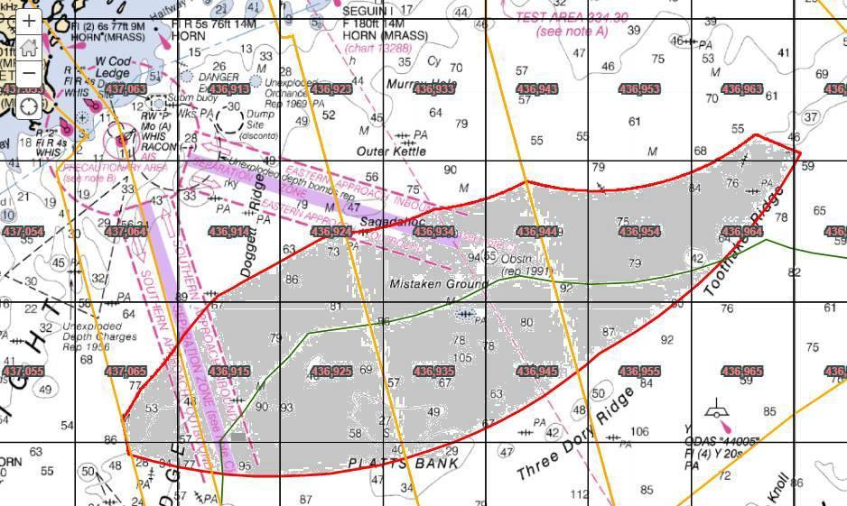
miles of ocean. The siting and permitting process is currently underway, with construction scheduled to begin in two to three years. Commercial and recreational fishermen, as well as environmentalists, have raised many concerns about the array’s potential location and what the effects might be on fish, marine mammals, and other wildlife as well as preemption of the bottom. The proposed general area includes about half of Twelve-Turbine Farm Already Being Planned Interestingly, NEAV is already hard at work planning a 12-turbine “research array” wind farm farther offshore in the Gulf of Maine, two to three years before the company will know whether its “experimental” turbine will actually work. Plattes Bank as well as the northern section of Jeffreys Ledge, two areas of significant historical and current importance to both commercial and recreational fishermen targeting tuna, sharks, groundfish, and other species. I recently spoke with the DMR official heading up the siting project, and conveyed RFA’s strong sentiments on where the array should definitely notbe placed The actual Monhegan Island test turbine is tiny compared with those to be built offshore. The proposed floating array, with turbines said to be 300 feet tall, will take up at least 16 square due to impacts on recreational fishing on these two valuable offshore grounds.
Governor Janet Mills’ Governor’s Energy Office is pushing development of this project, and is attempting to fast-track the permitting process for this May or June. This “research array” is expected to operate for some 20 years, begging the question as to whether it is indeed “research” or simply a smokescreen for a for-profit electricity generation project that will reward its investors. Isn’t the single turbine off Monhegan Island supposed to be the “experimental” project? In response to the backlash by fishermen to the12-array NEAV project, Gov. Mills on January 22nd, announced she would ask the Maine legislature to approve a 10-year moratorium on new wind projects in state waters, which extend three miles from shore but which would exclude the Monhegan turbine. The proposed moratorium would be largely symbolic, however, as offshore wind developers realized long ago that opposition to turbines that can be viewed from shore is virtually insurmountable nearly everywhere. The RFA will continue to monitor, and participate in, wind farm developments in the Gulf of Maine and will report as things unfold.

This chart shows the areas of interest for the siting of offshore floating windfarms. It covers major shipping lanes and a number of recreationally and commercially important fish habitats.


