ISSN 2348-1218 (print)
International Journal of Interdisciplinary Research and Innovations ISSN 2348-1226 (online)
Vol. 9, Issue 3, pp: (57-63), Month: July - September 2021, Available at: www.researchpublish.com

ISSN 2348-1218 (print)
International Journal of Interdisciplinary Research and Innovations ISSN 2348-1226 (online)
Vol. 9, Issue 3, pp: (57-63), Month: July - September 2021, Available at: www.researchpublish.com
Aditya Walke1 , Sanjay pathak2
1 MTech Student Town Planning Section, College of Engineering Pune, Maharashtra, India
2 Professor, Town Planning Section, College of Engineering Pune, Maharashtra, India
Abstract: The Centre is working on adopting the land-pooling methodology as an alternative mechanism for development and expansion of airports. Most of the airports are in congested parts of the city now that there is no scope for growth. data shows that many of the airports will reach saturation even after being expanded for lack of land availability[1]This thesis is focus on various land development model for expansion and uniform development, through land acquisition and land pooling to suggest land development policy for Airport development.
Keywords: Urban Expansion, Town planning scheme, Land acquisition, Airport land development.
India’s urban population account for 11 percent of worlds urban population and UN indicates that it will increase to 13 percent by 2030. it is also estimated that most of the population increase in India between 2015 and 2030 will take place in urban areas. Most Indian cities have grown organically and through accretion over time. The ever-increasing demand for urban land to meet the need of the growing urban population has led to expansion of cities on their peripheries this horizontal expansion of cities has largely been unplanned In India, Government Agencies have increasingly relied on Town Planning Schemes (TPS), Large scale acquisition of Land and Land Pooling for urban expansions and provision of basic infrastructure.[11]
Comparative Study of Urban Land Development models and its suitability for Development of International Airport at Purandar near Pune.
1.Comparative Analysis of LAA 1894 & RFCTLARR 2013
2.To study the Land Development Policy through town planning scheme in Gujarat
3.To study the Land Development Policy by CIDCO, for Navi Mumbai, Large Scale Acquisition of the land For New Airport and NAINA
4.To study the Land development model of Amaravati.
5.To study the Policy for development of township along Samruddhi Mahamarg (Mumbai - Nagpur)
6.To assess the effectiveness of above Policies and suggest suitable model for implementation of new Airport at Purandar.
ISSN 2348-1218 (print)
International Journal of Interdisciplinary Research and Innovations ISSN 2348-1226 (online) Vol. 9, Issue 3, pp: (57-63), Month: July - September 2021, Available at: www.researchpublish.com
The methodology adopted for the study are categories in two parts as Site analysis and Literature analysis. Different type of land acquisition model is study to analysis the effectiveness of the model their merits & demerits in literature analysis. The study will be based on secondary information, News articles and Primary survey and expert interview. In site analysis study area connectivity, slope study, demography & market rates are study. Based on the study proposal are formulated.
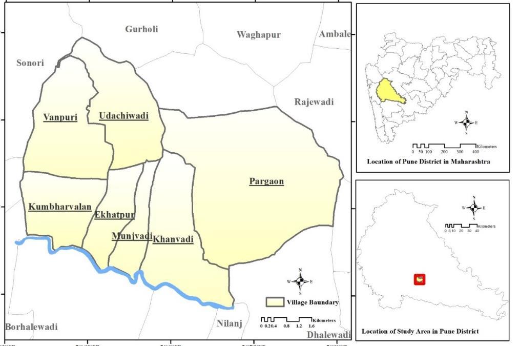
The Area is well connected by internal roads by Saswad Waghapur road and Saswad Memanepargaon road. Major access route are SH- 61 and SH – 63 from Pune city which connect to NH - 65. The rail network of Central Railway connecting Pune – Satara passes along the site area. Site is 40 km from Pune Station. Among the selected villages, Kumbharvalan, Vanpuri and Udachipuri comes under the PMRDA boundary while Ekatpuri, Munjawadi, Khanvadi and Pargoan are outside the PMRDA region.
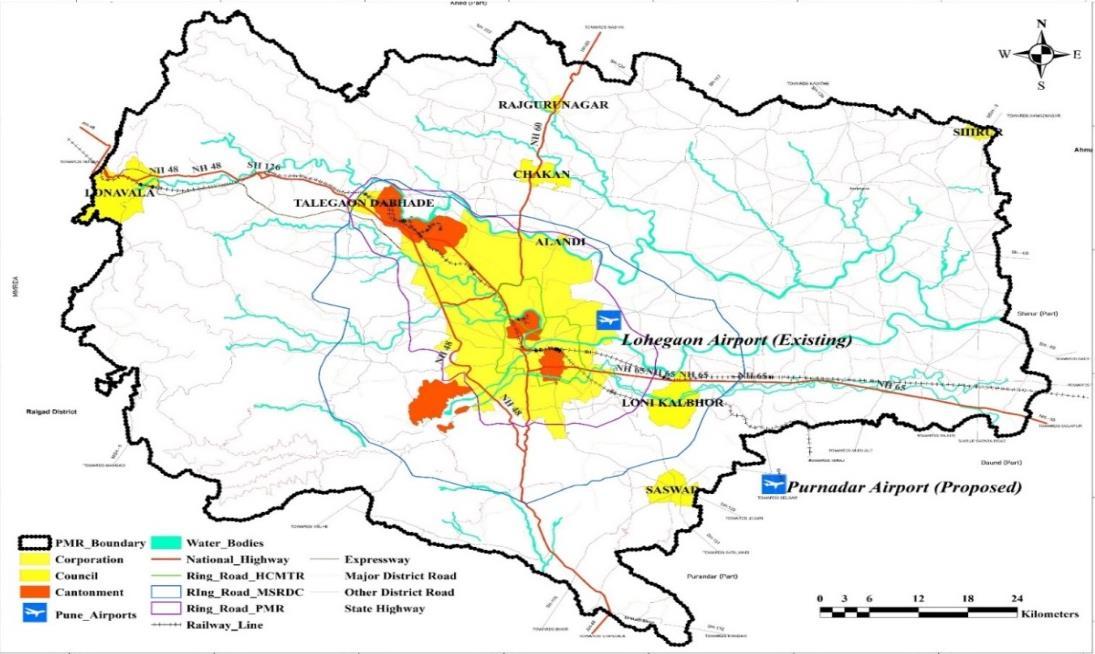
Fig 1. Study area (Purandar Airport)
5. REGIONAL CONNECTIVITY
FIG 2. PMRDA Map (Transport connectivity)
ISSN 2348-1218 (print)


International Journal of Interdisciplinary Research and Innovations ISSN 2348-1226 (online) Vol. 9, Issue 3, pp: (57-63), Month: July - September 2021, Available at: www.researchpublish.com
PMRDA at present has three main ring roads namely HCMTR in PMC boundary, MDRDC Ring road and PMR ring road. The existing airport at Lohegaon is near National Highway 65 and is well connected by State Highways to new proposed site. Also, it can be connected to MSRDC Ring road. Major Council areas like Chakan, Rajgurunagar, Lonavala, Loni Kalbhor, Saswad and Alandi are connected to proposed Airport at Purandar by Rail network and State Highways network.
Population - As per the 2011 census, Village has total population of 8275 person from which Pargoan has highest number of persons 2891 and Munjwadi has lowest population of 571 person [8]
Sex Ratio - Village has a sex ratio of 965 per 1000 male higher sex ratio than district and state. SC-ST population - The share of Scheduled Castes (SCs) and Scheduled Tribes (STs) population account for 6.8 % and 1 % respectively. Amongst all villages, Pargaon and Munjwadi has the highest share of SC population 211 persons. There are 4 villages named Vanpuri, Udachiwadi, Kumbharvalan and khanvadi without any ST population. Literacy rate - Villages has an average literacy rate of 66 %, which is less than the State and higher than National average literacy rates of 72% and 64.8% respectively as per 2011 census.[8]
NO. OF HOUSEHOLD

Economic Profile - The Workforce Participation Rate (WPR) of the area is nearly 57% with a total no. of workers 4787 as per 2011 census. Pargaon has the highest workforce participation. Lowest WPR is seen in Ekhatpuri and Munjvadi. Among the total workers, 96.5 % are main workers and 3.5 % are marginal worker. Of the total workers of 4787 in seven villages, 61% of workers are engaged in cultivation, 13% of workers are agricultural labourers, 1.5% are household workers and 22% are others. Pargoan has highest no. of cultivators. Cultivators in Munjvadi and Ekhatpuri has less. Munjvadi has no house hold workers.[8]


According to Primary Analysis of Contours and Slope, Vanpuri and Udachiwadi Villages are having the high and very High slope as shown in figures. The highest elevation observed in study area is 960 m at the North western side of Vanpuri and Udachiwadi Village while Lowest elevation (i.e.,712 m) is observed at South eastern part of the Pargaon Village. Around 85.36% area comes combined under Very Low, Low and Medium category, which indicates the high suitability of the selected villages for Airport construction.
B. LAND USE LAND COVER (LULC) STUDY (GIS ANALYSIS).
According to the analysis, Agriculture is the main and major land cover class identified in the study area constituting about 94% i.e., about 4883 hectares spread across seven villages. The village wise LULC distribution is shown in table. The percentage and areas of different land cover class in study areas is for dense vegetation (3.27 hectare, 0.063%), barren
ISSN 2348-1218 (print)
International Journal of Interdisciplinary Research and Innovations ISSN 2348-1226 (online) Vol. 9, Issue 3, pp: (57-63), Month: July - September 2021, Available at: www.researchpublish.com
land (0.13 hectare, 0.003%), waterbodies (45.4 hectares, 1.03%) and for built up (263.06 hectare, 5.12%). The village wise analysis shows that Paragaon is having high agricultural land i.e., 1850 hectares while Munjvadi have lowest agricultural land i.e., 226.9 hectares. Highest built-up land is estimated in Pargaon (209 hectare) followed by Khanvadi (34 hectare).
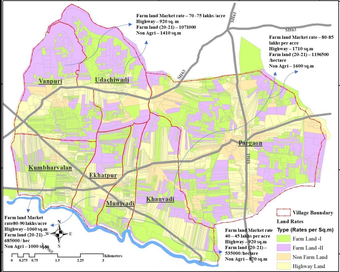
Comparing the 2015-16 & 2020-21 rates, it shows the average growth rates of 35 % in these 5 years with annual growth of 5 – 6%. The property registration in the vicinity of the seven villages earmarked for acquiring land for the proposed Purandar international airport nosedived by a little over 50% in 2019 compared to 2018.The number of registrations decrease to 38 in 2019, and 23.34 lakh stamp duty was collected. In 2018, A total of 136 documents were registered in the seven villages Khumbharvalan, Pargoan, Ekatpuri, Vanpuri, Udachiwadi, Khandvadi, Munjwadi and the stamp duty collection was Rs48.65 lakh. Pargoan and Khanvadi has the highest rates of land in study area & Munjvadi has lowest. According to a property registration official, framer will get 7.5 lakh per acre for unirrigated land and 15 lakh per acre for irrigated land.[7],[9]
In LAA 1894, Not everyone affected by Land acquisition is identified only land-owner are getting benefits and landless labours, encroachers who have interest in land were not compensated. No clear formula for how the compensation was calculated 1894 has a weak rehabilitation in the form of cash and some incentivise, there was no national policy for R & R till 2003
New policy consists of many expert committees at different stages. Due to the complex structure & process it may delay the process – project. Pre- notification process help/attract outsiders to purchase land in the area and the benefits not reaching the intended beneficiaries. Before to the notification publish increase in the land transactions. The new legislation provides for a maximum timeline of one year between the appraisal of the SIA Study and the preliminary notification. RFCTLARR Act has formed better rehabilitation measure considering major aspects comparing to LAA 1894
ISSN 2348-1218 (print)
International Journal of Interdisciplinary Research and Innovations ISSN 2348-1226 (online) Vol. 9, Issue 3, pp: (57-63), Month: July - September 2021, Available at: www.researchpublish.com
Comparing the above acts the RFCTLARR has great reform in land management formed a good institutional structure considering all aspects. It should categories in different size group of area and considerably reduce the complexity in acquiring land. Efficiency can be improved by through necessary amendments in the law to rationalise the time and cost.
The TPS has enabled more equitable allocation of urban land, obtain land for public purposes such as low-income housing, open spaces, roads, underlying utility infrastructure, and social amenities. The TP Schemes in Gujarat have proved to be successful instruments in reserving lands for infrastructure project and the same can be used effectively to allocate lands for the poor. In Sardar Patel ring road Land development through TP Scheme – Land acquisition mechanism leads to equitable, democratic and fair mechanism most to the land is acquired through TPS and rest through Land acquisition resulting in savings the land cost required for acquiring and uniform development along the highway
Initially, CIDCO has adopted Land Acquisition method, LAA 1894 for the land development but because of the protest over the period of time CIDCO started to adopted various schemes giving additional percentage of developed land over and above amount of compensation. Over the period of time, it is observed at the 40 – 50 % land required for the infrastructure development. Thus, the Town planning scheme is encouraged under MRTP act 1966 and Essential land is acquired through RFCTLARR 2013.Lack of strong policy backing & understanding problems of PAPs lead to changes in policy framework over the period increasing the time for acquiring the land
D. To study the Land development model Amaravati.
About 55 percent are agricultural labourers among total workforce in the capital city area in Amravati, about 55 percent are agricultural labourers. the state government to arrive at a more holistic package for the affected families that also included benefits to the landless families. Many options given to landowners to choose the type of plots in Land pooling scheme having total of 31 % of land return to landowners, benefits to the landowners and landless workers & attract the PAPs to participate in the scheme
E. To study the Policy for development of township along Samruddhi Mahamarg
Within 18 months, MSRDC managed to acquire 8861 hectares land required for the project. Initially MSRDC went for a land pooling strategy PAPs were against it & protested on ground. Eventually decided five times the value of the land (More than provided four-time compensation in the act) in addition to compensation for farm infrastructure, like loss of well, orchards encouraging farmers to participate in the planning process. Land acquisition through the new act failures to convince the PAPs & delay the project are mostly because of lack of communication between the agency & PAPs. The MSRDC appointed private communicators for land acquisition negotiations
ISSN 2348-1218 (print)
International Journal of Interdisciplinary Research and Innovations ISSN 2348-1226 (online) Vol. 9, Issue 3, pp: (57-63), Month: July - September 2021, Available at: www.researchpublish.com
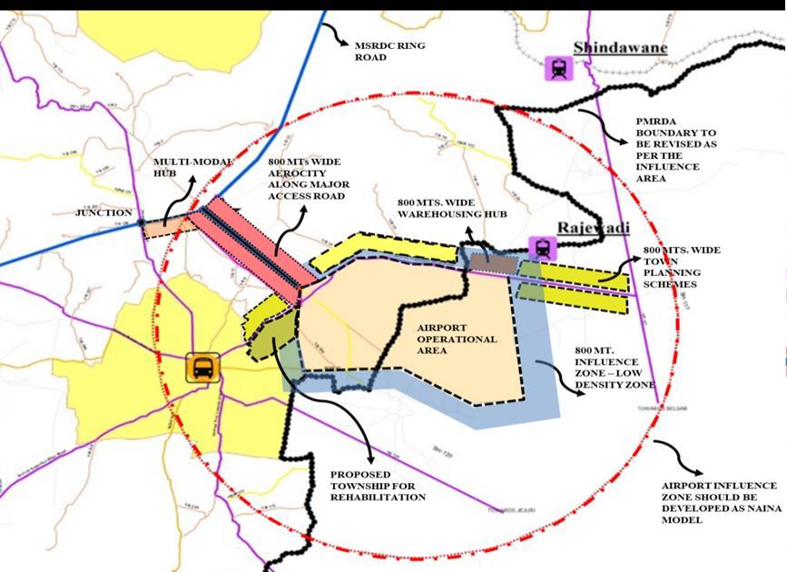
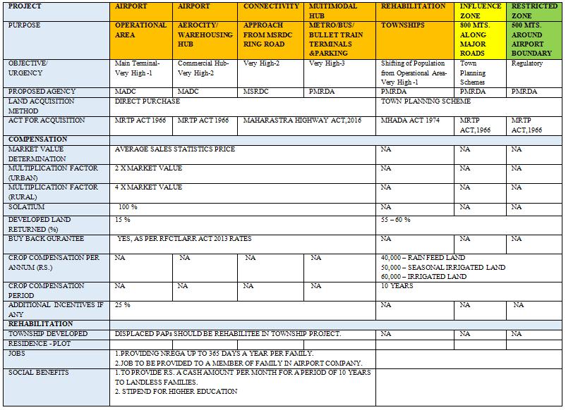
For acquisition of land, the land should be acquired according to the urgency of the project. For Airport project, the land has to acquire for operational area & it connecting activities to ease connectivity & uniform development around the proposed site. Aero – city, warehouse, multimodal hub, Integrated township is proposed for airport development.
1. Aero-city – Aero-city is defined as the functional area of a city that has the maximum concentration of commercial, retail and business centres near airport. For Aerocity land should be acquired through direct purchase The MADC can then adopted long-term leasing of land to private developers and allowed them to conduct development in the area to raise resources. Authority can use land value for financing the infrastructure.
2. Warehouse - International air freight exports and imports, the warehouse is essential for the storage of the goods use as transit space the warehouse can be used for collection operations, If the goods are shipped from different factories,. International airport warehouse can improve the efficiency of air freight & save customers air freight, and time, and, provide security. For Warehouse, land could be acquired through direct purchase and function under MADC.
3. Multi – modal hub - A Multi-Modal Transit Hub is multiple modes of transport, a transport node that interconnects, and, improves the efficiency and speed of movement. The Multi-Modal Transit Hub as combines it with passenger transitbased activities and also unites varieties of passengers as well as combines it with passenger transit-based activities.
As metro station is proposed from Hadapsar to Saswad, and Proposed Mumbai - Hyderabad bullet train route passing through Pune via Saswad, a transportation hub should develop along MSRDC ring road near Airport site which will increase connectivity within city and major cities impacting economic growth.
4.Integrated Township - Integrated Townships are mammoth real estate projects that have both residential and commercial complexes, and all associated infrastructure like roads, schools, colleges, hospitals, shopping centres, water treatment plants. Integrated township should be developed for PAPs under direct land purchase for rehabilitation, location for township & should be in outskirt of Saswad tehsil for better functioning and connectivity
For airport area, Major land should be acquired from Munjvadi, Ekhatpuri, Khumbharvalan, Vanpuri, suitable for direct purchase as land rates are comparatively less than Pargoan and khanvadi. According to the topography analysis the study area shows the high suitability for airport construction, among the selected villages only Vanpuri and Udachivadi having high & middle slope on the north side should be avoided for land acquisition. Pargaon has more settlements consisting 653 household, so minimum land as possible as should acquire through direct purchase to reduce the displacement in the area. Pargaon has high land rates and significant population density hence only 10% of the total land is considered form Pargaon village. For Aerocity, Sonari – Vanpuri district road should considered connecting PMRDA ring road & airport has 3.5 km from airport site. Warehouse is proposed near Rajwadi railway station and having connectivity to NH-65 through SH - 117 which will be better for transportation of goods logistics.
ISSN 2348-1218 (print)
International Journal of Interdisciplinary Research and Innovations ISSN 2348-1226 (online) Vol. 9, Issue 3, pp: (57-63), Month: July - September 2021, Available at: www.researchpublish.com
According to comparative study of various land development model, it is observed that due to lack of wholesome policy & slow response of bureaucracy led to extension in time period for TP scheme & land acquisition need to address & improve while making the policy for the project. Participatory planning should improve for the better understanding of PAPs. Land Acquisition through direct purchase policy is observed as the fast & better method for land acquisition in less time frame. For direct purchase policy, it depends upon urgency of project & PAPs aceeptance
[1] ENS Economic Bureau “Airport Expansion: Government likely to adopt land pooling method” The Indian Express Sept 19,2021
[2] N. K. Patel “Town Planning Scheme in India”, by ITPI journal, Volume: 16, Number: 4
[3] Sardar Patel ring road, Ahmedabad Urban Development Authority (AUDA) https://www.auda.org.in/
[4] Suresh Babu (Additional Chief Planner, CIDCO) “Land Pooling for Smart Cities” - https://niua.org/cidco/landpooling-for-smart-cities/
[5] Innovative & inclusive land pooling scheme. APCRDA. https://smartnet.niua.org/content/273fd8f2-59e1-413b-a49a7768cd4ef9a9
[6] Samruddhi Mahamarg land development – MSRDC https://www.mahasamruddhimahamarg.com
[7] Property registration dip Purandar – Times of India. https://timesofindia.indiatimes.com/city/pune/50-dip-inproperty-deals-in-seven-purandar-villages/articleshow/65193298.cms
[8] Census of India 2011 - https://censusindia.gov.in/
[9] Aunnal Statement Rates - http://igrmaharashtra.gov.in/
[10] D. S. Meshram, Ph.D. “A Comparative Analysis of LAA, 1894 and LARRA, 2013”., ITPI journal, Volume: 16, No: 4
[11] ” Pilot on Formulation of Local Area Plan (LAP) & Town Planning Scheme (TPS) For Selected Cities”, July 2018