ISSN 2348-1218 (print)
International Journal of Interdisciplinary Research and Innovations ISSN 2348-1226 (online) Vol. 10, Issue 1, pp: (47-52), Month: January - March 2022, Available at: www.researchpublish.com

ISSN 2348-1218 (print)
International Journal of Interdisciplinary Research and Innovations ISSN 2348-1226 (online) Vol. 10, Issue 1, pp: (47-52), Month: January - March 2022, Available at: www.researchpublish.com
1. Assistant Professor, Department of Civil Engineering, Government Engineering College, Ramanagara 562159
2. Professor & Director, Building Fire Research Centre, The National Institute of Engineering, Mysore 570008
3. Professor, Department of Civil Engineering, Dayananda Sagar Academy of Technology & Management, Bengaluru 570008
Abstract: Natural hazards are repeated in Madikeri since 2018 that take place during monsoon and damage crops, livestock and settlements. Data on flood, drought, cyclone and waterlogging were collected. Heavy rainfall not only cause floods and debris flows, but also trigger off landslides on steep slopes. The danger due to these slope instabilities is considerably high, as they often evolve into debris flow that may damage cultivated land, buildings and infrastructures, and even cause fatalities. This paper discusses certain technical aspects of the landslides at various locations of kodagu district that triggered off by heavy rainfall in the season of July - August 2018. This article concentrates on the documentation and analysis of rainfall events, with a focus on evaluating the effects of urbanization on landslides. It summarizes the results of one landslide inventories after severe rainstorms in Kodagu during the previous month (August 2018), concentrating on the observations during field surveys and similarities between forest and open land.
Keywords: flood, drought, cyclone, heavy rainfall, landslides.
Landslides at different locations of kodagu district that triggered off by heavy rainfall with around 40 days of continues precipitation during the months of July and August 2018. On 17th August 2018, several landslides of different dimensions occurred at Kodagu district (Southern Indian –Western ghats) after a long rainy period. Landsliding is the most important geomorphic process in humid mountains; it can also be the most dangerous. The term “Landslide”, may be referenced to a sliding motion, for all varieties of mass-transport deposits (MTD), which include slides, slumps, debrites, topples, creeps, debris avalanches etc. Slides represent the pre-transport disposition of strata and their reservoir quality (ie. porosity and permeability) of the provenance region, whereas debrites reflect post-transport depositional texture and reservoir quality.
These Landslides problems have enormous implications for studies in sedimentology, engineering geology, oceanography, geomorphology, volcanology, seismology, glaciology, areology (i.e., geology of Mars), deep-sea structural engineering, highway engineering, soil mechanics, climate change, natural hazards, petroleum exploration and production.
Since the early recognition of “landslides” in 186 BC in China (Li, 1989), their common occurrences in subaerial and submarine environments have been well documented worldwide. The data on worldwide damages caused by large subaerial MTD in the 20th and 21st centuries is presented in Table 1.
ISSN 2348-1218 (print)
International Journal of Interdisciplinary Research and Innovations ISSN 2348-1226 (online) Vol. 10, Issue 1, pp: (47-52), Month: January - March 2022, Available at: www.researchpublish.com
Table 1: Worldwide large Mass-transport deposits (MTD), their sizes (volume) and damages in the 20th and 21st Centuries.
Year Location
Name and type Triggering mechanism Size, damage, and loss of human life
1921 Kazakh Republic Alma-Ata debris flow Snow melt, subsequent rainfall 500 deaths
1938 Japan (Hyogo) Mount Rokko MTD Rainfall
505 deaths or missing, 130,000 homes were destroyed or badly damaged.
1941 Peru Huaraz debris flow Failure of moraine dam 10,000,000 m3 4,000-6,000 deaths
1945 Peru Cerro Condor-Sencca MTD Erosional under-cutting 5,500,000 m 3 13 bridges were destroyed
1953 Japan (Wakayama) Arida River MTD Rainfall Major typhoon (cyclone) 1,046 deaths
1953 Japan (City of Kyoto) Arida River MTD Rainfall 336 deaths 5,122 homes were destroyed.
1958 Japan (Shizuoka) Kanogawa MTD Rainfall 1,094 deaths 19,754 homes were destroyed.
1962 Peru (Ancash) Nevados Huascaran MTD Not known 13,000,000 m3 4,000-5,000 deaths
1963 Italy (Friuli-Venezia Griulia) Vaoint Reservoir MTD Not known 250,000,000 m3 2,000 deaths
1965 China (Yunnan) MTD Not known 450,000,000 m3 444 deaths.
1966 Brazil (Rio de Janeiro) MTD Rainfall 1,000 deaths
Year Location
Name and type Triggering mechanism Size, damage, and loss of human life
1974 Peru Mayunmarca MTD Rainfall
1980 China (Yichang, Hubei) Yanchihe MTD Mining activity-occurred on man-made layered slopes
1980 United States (Washington) Mount St. Helens MTD Eruption of Mount St. Helens volcano This is the world’s largest historical MTD.
1983 United States (Utah) Thistle MTD Snow melt and subsequent rainfall
1,600,000,000 m3 450 deaths
150,000,000 m3 284 deaths
3,700,000,000 m3 250 homes, 47 bridges, 24 km of rail, and 298 km of highway were destroyed; 57 deaths.
21,000,000 m3 ; This is the most expensive disaster to fix in U.S. history with a loss of $600,000,000 (1983 dollars).
1983 China (Gansu) Saleshan MTD Rainfall 35,000,000 m3 237 deaths
1983 Ecuador Chunchi MTD Rain and/or snow (wettest year of century) 1,000,000 m3 150 deaths
1985 Puerto Rico (Mameyes) MTD Rainfall from tropical storm 129 deaths
1987 Venezuela Rio Limon, debris flow Rainfall
1988 Brazil Rio de Janeiro and Petropolis MTD
Rainfall
2,000,000 m3 210 deaths
Approximately 300 deaths
ISSN 2348-1218 (print)
International Journal of Interdisciplinary Research and Innovations ISSN 2348-1226 (online) Vol. 10, Issue 1, pp: (47-52), Month: January - March 2022, Available at: www.researchpublish.com
1989 China (Huaying, Sichuan)
1991 China (Zhaotong, Yunan)
1991 Chile
Xikou MTD Rainfall 221 deaths
Touzhai MTD Rainfall
18,000,000 m3 216 death.
Antofagasta debris flows Rainfall
1993 Ecuador La Josefina MTD Mine excavation and heavy rainfall
Year Location
1998 Northern India (Malpa Himalaya Region)
1998 Italy (Campania)
Name and type
Triggering mechanism
500,000,000-700,000,000 m3 “Hundreds” of deaths were reported
20,000,000-25,000,000 m3 13 bridges destroyed
Size, damage, and loss of human life
Large MTD Rainfall 221 deaths
MTD Rainfall
1998 Honduras, Guatemala, Nicaragua, El Salvador MTD heavy rain fall
1999 Venezuela (Vargas, northern coastal area)
More than 100 individual slope failures
Rainfall Hurricane Mitch caused torrential rainfall. Approximately 10,000 deaths
MTD Rainfall
Nearly 1m of heavy rain fall in a 3-day period. There were as many as 30,000 deaths. Loss: $1,900,000,000 in 2001 U.S. dollars
2000 Tibet Yigong MTD Meltwater from snow and glacier 100,000,000 m3 109 deaths
2002 Russia (North Ossetia) Kolka Glacier debris flows Detachment of large glacier, causing a debris flow
2003 Sri Lanka (Ratnapura and Hambantota)
2003 United States (San Bernardino County, California)
2006 Philippines (Leyte)
2008 Egypt (East Cairo)
2010 Uganda (Bududa)
2010 Brazil (Rio De Janeiro)
MTD Rainfall
Travel distance: 19.5 km; 110,000,000 m3 volume of glacial ice deposited 2,000,000-5,000,000 m3 of ice debris at end of runout; 125 deaths
24,000 homes and schools destroyed, 260 deaths
Debris flows Rainfall >1,000,000 m3 (total volume) 16 deaths
MTD Rainfall 15,000,000 m3 1,100 deaths
Al-Duwayqa MTD Destabilization due to manmade construction
Affected area was 6,500 m3 volume and rocks weighed about 18,000 tons.107 deaths
Debris flows Heavy rainfall 400+ deaths
Debris flows Heavy rainfall 350 deaths
Kodagu is located on the eastern slopes of the Western Ghats. It occupies an geographical area of 4,102 square kilometres in the Western Ghats of south-western Karnataka. The district has a mountainous configuration, which presents a grand panorama of verdant valleys, ravines, fast flowing streams, lofty peaks, and awe-inspiring spurs. Most part of the district is covered with thick vegetation. The topography of the area ranges from gently sloping plains on the south eastern part to
ISSN 2348-1218 (print)
International Journal of Interdisciplinary Research and Innovations ISSN 2348-1226 (online) Vol. 10, Issue 1, pp: (47-52), Month: January - March 2022, Available at: www.researchpublish.com
rugged hilly lands, with elevations ranging from about 910 m above mean sea level to 1,908 m above mean sea level. The hills and valleys of this undulating region are generally aligned in NW-SE direction.
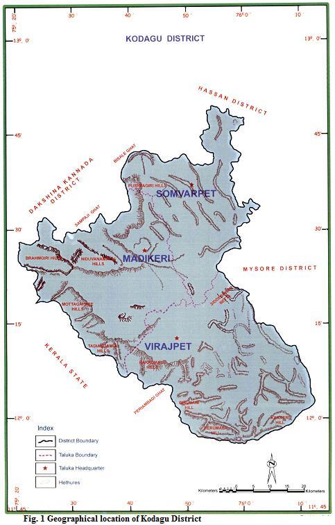
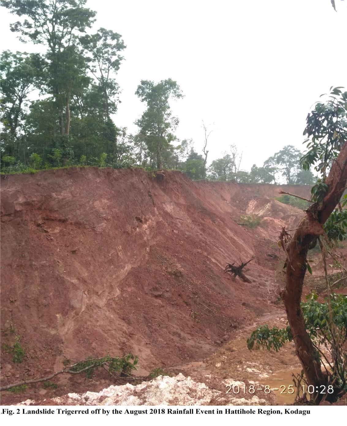
Hattihole a small village which is the study area of the landslide described in this article is located at around 15 kilometers from Suntikoppa along the road connecting between Madikeri and Somwarpet as shown in figure 1.
Information from the local public at flood rehabilitation centres of Suntikoppa area is used to locate the Hattihole landslide site which is as shown in Figure 2. The data from Indian meteorological department, Bengaluru showed that, Talacauvery received 375 mm of rainfall in 24 hours (from 8 a.m. on Monday 13-08-2018). This is said to be a record amount of rainfall on one day in the past few years. Somwarpet received 52 mm of rainfall, Madikeri 106.4 mm, Bhagamandala 113.2 mm and Virajpet 185.8 mm rainfall in 24 hours beginning 8 a.m. on Monday (13-08-2018). In the corresponding period last year (2017), Somwarpet had not received any rain while Madikeri had received 1.5 mm, Bhagamandala 17.6 mm and Virajpet 12.2 mm. The precipitation data showed that 45% (768mm) of the August rainfall was received within three days i.e., August 15, 16, 17. Such a high quantum of rain within a short duration of 72 hours could be the reason for heavy landslides in the history of Kodagu district. During heavy rains, when underground water percolates the sloping layers, it might have resulted in erosion of soluble mineral salts in the rock mass, thereby creating fissures and fractures inside the sloping ground that disturbs the strength of the slopes, resulting in landslides.
ISSN 2348-1218 (print)
International Journal of Interdisciplinary Research and Innovations ISSN 2348-1226 (online) Vol. 10, Issue 1, pp: (47-52), Month: January - March 2022, Available at: www.researchpublish.com
It is evident from Figure 2 that slope inclination is a crucial factor for slope stability. On slopes with an inclination of less than about 20°, the driving forces are normally low compared to soil strength. On slopes steeper than 45°, the landslide density decreases resulting in the dislodging of heavy mass (Residential Building) from its original position.
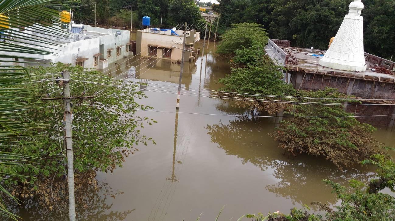
Due to this heavy rains, and high rate of inflow to the Harangi dam, Around 40,000 cusecs of water was discharged from the Harangi dam resulting in submerging Some localities (Sai Layout, Kuvempu Layout and Kariappa Badavane) in Kushalnagara town which were flooded as shown in Figure 4. This is due to the fact that these layouts were existing very close to the river Cauvery.
The physical processes that are responsible for transporting sediment downslope into the valley are still to be explored. This is simply because the physics and hydrodynamics of these processes are difficult to observe and measure directly in the cyclone affected environments. This observational impediment has created an enormous challenge for understanding and communicating the mechanics of gravity-driven downslope processes with clarity. Furthermore, deep-understanding of the soil material at liquefying environments are known for their complexity of processes and their deposits, composed not only of mass-transport deposits but also of bottom-current reworked deposits.
ISSN 2348-1218 (print)
International Journal of Interdisciplinary Research and Innovations ISSN 2348-1226 (online) Vol. 10, Issue 1, pp: (47-52), Month: January - March 2022, Available at: www.researchpublish.com
Fig.3: Image of the flooded area at Sai Layout, Kushalanagara.
The most important conclusions are summarized below.
1. Volunteers with expertise and powers to coordinate all disciplines and phases in such disaster locations is a basic requirement.
2. Forests around Hattihole area are actually on steeper slopes that are more susceptible to landsliding.
3. The infrastructure road connecting Madikeri-Somwarpet and similarly flood affected areas has delayed the rehabilitation tasks.
4. With this large scale Landslides many of the local public in kodagu living on the hills found themselves homeless when their dwellings caved in under the onslaught.
5. Uncontrolled urbanization close to the stream flow leads to submerge the whole area as a consequence of maximum discharge through the reservoirs.
6. Evolving a participatory pre- and post-disaster management plan and taking a multidisciplinary approach based on scientific inputs on the causes and remedies are needed much attention.
The writers wish to acknowledge NSS Volunteers and under graduate students of Government Engineering College Ramanagara for their assistance in the Rehabilitation tasks for Flood Victims of Kodagu and during Field Surveys for the research reported in this paper.
[1] Flood Victims Rehabilitation centres, Suntikoppa.
[2] Taluk Panchayat office, Kushalanagara, Government of Karnataka.
[3] Deccan Herald, English daily News Paper.
[4] Prajavani, Kannada daily News Paper.
[5] Times of India, English daily News Paper.
[6] Google website.
[7] Website of Karnataka state Natural Disaster Monitoring Centre.
[8] Special Camp Report of NSS-2019, Government Engineering College Ramanagara.