5 minute read
Head for the Hills


HEAD for the

Advertisement
for the HILLS
CAHOKIA MOUNDS is a mind-bending window into a past world
By Danny Wicentowski THE METRO EAST, like the
rest of Illinois, is a mostly vast expanse of flat, swampy prairie, but about a thousand years ago, a little-understood native culture built massive earthen mounds that now exist as evidence of a complex and densely populated city — which at its height included rings of “suburb” dwellings that extended across the river to the areas of present-day St. Louis.
Today, the Cahokia Mounds State Historic Site (30 Ramey Street, Collinsville, IL) is spread out over three-and-a-half miles of crisp green grassland — and is dominated by the 100-foot-tall Monks Mound. Taking the stairs to the top platform, the view extends for miles.
However, before attempting to surmount the mound, visitors should head to the interpretive center — which is different than a museum, notes archeologist and the center’s executive director Lori Belknap.
“Our goal is that the visitors would leave with an understanding of the life of the people who lived here a thou-
sand years ago,” she explains. “That interpretation given to visitors is grounded in science. Everything we are telling you are things that we have learned through excavations, and we keep it very close to the actual data we recovered in early digs.”
Along with hundreds of excavated artifacts, the center’s exhibits illustrate the remarkably urban existence of the nearly 20,000 residents believed to have lived, worked and died in Cahokia at its height around the year 1200 A.D.
Though they left behind no writing, the Cahokians did leave structural demonstrations of their knowledge, including “Woodhenge,” a solar calendar of wooden posts that’s been functionally rebuilt on the site. Every year, on solstice and equinox, crowds gather in the ancient circle to watch the sunrise.
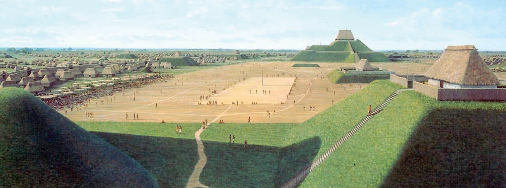
That the center is dedicated to interpretation, not just preservation, also hints at the mystery of the fate of the Native American culture that thrived here. Only a tiny part of the total area has been excavated, and researchers have spent years looking at the possibilities presented by the evidence they uncover. The Interpretive Center lays out these threads with lushly illustrated maps and
models, as the galleries and exhibits tell the story of the end of a powerful civilization, one that had once been part of a continent-spanning trade network and religious system that was already centuries gone by the time the first Europeans arrived.
The Cahokia represents the largest settlement of “Mississippian” culture, which in Southern Illinois grew to a population of tens of thousands by maintaining huge agricultural operations. Today, the people are gone, but the impact of their lives and work remains. Belknap argues that it’s important that the current residents recognize the depth of history in the land around them.
“Our site dominated that area at the time,” Belknap says. “It went into East St. Louis and across the river. It was a very large civilization here, and it’s important for people to understand that.”
She says the center hopes that easing pandemic restrictions in the coming months will allow the site to schedule its usual array of kids and archeology events for the year. In the meantime, the walking and hiking paths remain open, covering sixteen total miles in a loop through the peaceful, mound-punctuated landscape. The Interpretive Center is open to the public, though visitors are asked to RSVP at 618-346-5160 so the center can maintain an occupancy limit and social distancing. n
opening page: Modern-day mounds stand as mute testament to the societies that preceded us along the Mississippi River. Photo: Danny Wicentowski | above: A depiction of the day-to-day life of the culture that created the mounds. Photo courtesy Cahokia Interpretive Center


GREAT FUN ON THE GREENWAYS
Get Outside on St. Louis’ Growing Network of Greenways
St. Louis is known for the Gateway Arch, Forest Park and the Mighty Mississippi. But did you also know it is home to a growing network of greenways connecting the region’s parks, rivers, cultural landmarks and communities?
In 2000, voters in St. Louis City, St. Louis County and St. Charles County dreamed big by voting for and investing in a dynamic network of parks and open space. This vote created Great Rivers Greenway, the public agency tasked with building, bringing to life, and caring for a planned 600 mile network of greenways.
What is a greenway? More than just a trail, greenways are outdoor spaces that connect people and places. No two greenways are alike; some travel through quiet wooded areas, others offer a more urban experience connecting to shopping districts, transit, parks and neighborhoods. They meander along rivers, climb bluffs, and wind behind neighborhoods and businesses to provide direct connections to the places you want to go. They also reveal hidden views and panoramic vistas you’ll never see from a parking lot or behind the wheel of a car.
Thanks to the voter’s vision and foresight, there are nearly 130 miles of greenways to explore and enjoy on foot, bike, or wheelchair. The next time you want to explore the St. Louis region— try a greenway. The journey will be as much fun as the destination! Find a greenway near you at
GreatRiversGreenway.org Come Explore St. Louis City, St. Louis County, and St. Charles County Via the Greenways!
It’s easy to plan your trip by visiting GreatRiversGreenway.org. There are three ways to find greenways; a list, a map and an interactive search feature. You can search by keyword, location, or by selecting detailed search criteria. Some of the options include what you want to see or do (explore history, grill, play); favorite type of trail (paved, hilly or flat) or distance. You can also identify your ideal greenway experience with choices such as shady or sunny, urban or rural or those that offer river views. The website also offers detailed information about the region’s greenway, special events, project updates and more.
Chase a New VIEW