
47 minute read
by eric losang


F. Ferrarese - a. Bondesan • Il fronte del fIume PIave dalle carte mIlItarI del 1917-18 77
Francesco Ferrarese, Ugo sauro & Christian tonello, « The Montello Plateau. Karst evolution of an alpine neotectonic morphostructure », Zeitschrift für Geomorphologie, supp. Band 109 (1998), pp. 41-62. Peter Fiala, 1918 il Piave. L’ultima offensiva della duplice monarchia. A cura di Giulio Primicerj. Con annessa relazione ufficiale austriaca, Arcana, Milano, 1982. Nicola Fontana, « La cartografia militare austro-ungarica nella Grande Guerra », in Aldino Bondesan & Mauro scroccaro (cur.), Cartografia Militare della Prima guerra mondiale. Cadore Altopiani e Piave nelle carte topografiche austro-ungariche e italiane dell’Archivio di stato di Firenze, Antiga Edizioni, Regione Veneto, Archivio di Stato di Firenze, Università di Padova, Marco Polo System, Cornuda, 2016, pp. 55-62. Luigi gasParotto, Rapsodie, diario di un fante, Treves, Milano, 1924. Carlo meregalli, Grande Guerra sul Montello. Sul “Carso verde”, l’ala infranta di
Advertisement
Baracca, Tassotti, Bassano del Grappa, 2000. Mauro scroccaro, « Sui cieli del nemico », in Aldino Bondesan & Mauro scroccaro (cur.), Cartografia Militare della Prima guerra mondiale. Cadore Altopiani e Piave nelle carte topografiche austro-ungariche e italiane dell’Archivio di stato di Firenze, Antiga Edizioni, Regione Veneto, Archivio di Stato di Firenze, Università di Padova,
Marco Polo System, Cornuda, 2016, pp. 41-54. Roberto tessari, Paolo gasPari & Corrado callegaro, Il Montello, Vol. 1 e 2, Gaspari,
Udine, 2008. Elena torretta, Alessandro di rita, « L’evoluzione della fotogrammetria da terrestre ad aerea », La Cartografia 17 (2008), pp. 20-29.
78 NAM ANNo 3 (2022), FAscicolo speciAle 2. setteMbre 2022 MilitAry cArtogrAphy
War Atlases of World War I Germany:
Informing the Masses about the Global Battleground
By eric losang Leibniz-Institute for Regional Geography, Leipzig
79
aBstract. This paper reflects the development of the demand for detailed information about the battlegrounds and the solutions of different publisher groups, e. g. newspaper publishers and specialized mapping companies and institutions in Germany, to meet the growing demand. The paper analyses the structure, content and visualization modes of selected atlases as well as the different European markets (with a focus on German publishers) for war atlases. The resulting tentative picture suggests that this otherwise neglected type of atlas contained early forms of on-demand publications for the public.
keyWords- War atlas, WWi, germany, maP Production
Introduction
When in 490 BC the messenger Pheidippides brought the news of the Athenian victory at the battle of Marathon to Athens, he fulfilled a task, that is nowadays covered by the media in almost real time. Informing people on what happened on the battlefields was the subject of contemporary oral narratives and diaries for long time. From hand-written Avvisi (newsletters) to printed newspapers, from paper to digital, the description of conflicts and wars have always been of interest for those who didn’t directly take part in combat activities. To grasp the sense of war requires understanding its underlying spatial concepts, thus maps and war are inseparably linked in our thinking1. Even for the understanding of cyberwars, maps – of whatever type – are indispensable.
Maps have been used in different settings in war times, “notably for geopolitical consideration, strategic planning, operational purposes, tactical grasp, news
1 Oliver kann, Karten des Krieges. Deutsche Kartographie und Raumwissen im Ersten
Weltkrieg, Paderborn Ferdinand Schöningh, Leiden, 2020, p. 1.
80 NAM ANNo 3 (2022), FAscicolo speciAle 2. setteMbre 2022 MilitAry cArtogrAphy
reporting and propaganda”2. Accordingly, the types of maps used in wars considerably differ and need to be analyzed in relation to their communication objective. Atlases, however, are different. They are deliberate and systematic combinations of maps, that have been put together in order to reflect a specific view or to solve a specific task3. On the one hand their communicative ability tends to be far more sustainable, on the other they are inappropriate to disseminate spatial circumstances that change at short notice.
1 WaR atlases
There are multiple ways to systematize types of atlases. As the paper focuses only on German war atlases produced during WWI a functional, rather than spatial and temporal, approach seems appropriate.
1.2 Historic war atlases
Most war atlases are historic atlases, retrospectively arranging maps to comprehensively visualize the spatial aspects on origins, actions and outcomes of armed conflicts, very often omitting historic cartographic material in favor of modern maps, following the paradigm of “rough uniformity of map format, design, and presentation throughout”4. In this context historical maps often play a mere illustrative role and are rarely interpreted. Published shortly after a war, atlases embed predominant revanchist tendencies in texts and visualizations (e. g., the depiction of borderlands).
In French and German cartographic treatises about the Franco-Prussian War in 1870/71 maps on Elsass [Alsace]/Lothringen [Lorraine] are the most important cartographic content. These historic atlases, to an increasing extent, feature also propagandistic elements after 1890, thus predicting an upcoming conflict.
2 Jeremy Black, Maps of War. Mapping Conflict through the Centuries, Conway, London, 2016, p. 6. 3 Ferjan J. ormeling, « Atlases », in Bengt rysted B., Ferjan ormeling (eds.) The World of
Maps, International Cartographic Association, Stockholm, 2014. 4 James akerman, « From Books with Maps to Books as Maps: The Editor in the creation of the idea », in Joan Winerals (ed.), Editing early and historical atlases. Papers given at the 29th annual conference on editorial problems, University of Toronto 5-6 November 1993,
University of Toronto Press, Toronto, 2016, p. 4.
Eric Losang • War atlases of World War I Germany 81
1.2 War atlases as a tool of warfare
Very seldom tactical, operational or strategic maps have been published during the war as atlases for further use in the field. In those cases, they merely function as container “to keep the maps all together in one convenient place, to reduce wear and tear, to know where they’re at”5. Those kinds of “working atlases” have been known since maps became an indispensable part of spatial operations such as explorations. Very often, they have been published well before specific conflicts, e. g. as strategic spatial inventories of possible war theatres like the portolan atlases of the 16th century and the Petit Atlas Maritime that Nicolas Bellin produced on behalf of French naval ministry in 1764 in the aftermath of the Seven Years’ War.
1.3 War atlases as propaganda tools
In war times published information is often used to influence the opinion of the public or of targeted readerships. Facts are generalized and visualized according to the needs of political influence, often emotionally charged and visually exaggerated. Many war atlases treated in this article show at least some of these characteristics: mainly through textual additions, such as rather patriotic prefaces or nationalist editorials (e. g., the first edition (1914) of the Neuester Kriegs-Atlas), and embellishing additions of militaria. Propaganda atlases, addressing strategic and geopolitical interests, flourished in the interwar period on the brink of, and during WWII. An interesting example is the War Atlas published by the Philadelphia Inquirer in 1942, just weeks after the attack on Pearl Harbor. Besides persuasive maps it provided information on planes, ships, weapons, military training and on the important targets in enemy states, expressing a pursued positive mood towards the upcoming war.
1.4 War atlases to imagine the “Kriegsschauplätze” (theatres of war)
These atlases were produced to inform about the different places and areas where the armed conflicts took place or places to which combat activities could possibly have extended. Such theatres of war maps were small-scale overviews
5 Denis Wood, « Pleasure in the idea. The atlas as narrative form », Cartographica 24/1 (1987), p. 29.
82 NAM ANNo 3 (2022), FAscicolo speciAle 2. setteMbre 2022 MilitAry cArtogrAphy
of spaces that were related to the conflict rather than precise depictions of front lines6, that were - if information was available - the domain of short-term updated newspapers and magazines. Predecessors of this kind of war atlas were often produced to give newsreaders a visual reference, that complemented the rather largescale information published on a daily or weekly basis. Comprising between 10 and 30 maps, they were cheaply produced and often costed less than one of the larger war maps by Flemming or Ravenstein that only covered one area. Such small atlases found a wider distribution, and existing copies often contain notes and remarks, either tracing family members or used by soldiers in the trenches as a “cartographic diary”.
This paper will focus on the latter atlases produced during WWI with spatial emphasis on Germany, where high standard map production had already spawned an industry with important printing companies in Leipzig, Berlin, Gotha and Munich. With the beginning of the war in August 1914 those businesses often suffered from a loss of workforce due to troop mobilization, impeding publication of their traditional products. In fact, most traditional atlas businesses didn’t publish new editions (except school atlases) between 1914 and 1920. Thus, to many lithographic and geographic institutes, the production of war maps and small war atlases became an important substitute source of income.
2 The development of war atlases to meet peoples’ demand for information on the theatres of war.
2.1 Early war atlases for news seekers
One of the first atlases of this kind is Rizzi Zannoni’s Atlas géographique et militaire ou Théâtre de la Guerre présente en Allemagne that was co-published in 1762 by Baillard (Paris) and engraver Lattré (Bordeaux); the titlepage, engraved by P.P. Choffard, was dated 1761. In contained several detailed maps of Germany depicting the battlefields of the Seven Years’ War and was extended in several editions in the following years.
Another example was the Kriegsatlas zum Gebrauch für Zeitungsleser, published between 1794 and 1799 in Vienna. Distributed by Johan Otto and engraved by Johann Wenzel Engelmann, the atlas comprises 24 hand-colored copperplate
6 KANN, 2020, p. 318.
Eric Losang • War atlases of World War I Germany 83
maps covering theatres of the French Revolutionary Wars. Again, the maps didn’t take on the battles, retreats, and advances, but helped to locate news about combat operations. Besides overview maps of Europe and France (including a map of Corsica) the atlas’ focus is on the regions of Northern France, the Rhine and Mosel area and the Franco-Italian and Franco-Spanish borderlands extensively depicting valuable topographic information.
With the development of faster communication modes distant, and even foreign, wars became the subject of daily/weekly news. In 1854 C.A. Hartleben’s Verlags-Expedition in Pest [Budapest], Vienna and Leipzig published the Kriegsatlas für Zeitungsleser covering the historical circumstances as well as the geographic extent of the Crimean war. It contained six hand-colored small-scale maps covering the areas of fighting – again titled as “theatres of war”.
Although intended to inform newspaper readers it took until the late 19th century that news publishers themselves started publishing war atlases intended to supplement their daily news with maps, often licensed by well-known cartographic publishers.
2.2 Maps for the masses
Wars always “heightened the peoples’s appetite for news and challenged the ingenuity of the pictorial press”7. During the Crimean and the American Civil wars, newspapers and magazines started to publish battlefield sketches and maps on the combat zones on a regular basis. According to Monmonier, inexpensive and improving engraving and printing techniques – the basis for an establishing ‘yellow journalism’8 – paved the way for maps to become a regular part of war coverage9. Public empathy and the need for information about battlefield actions became especially strong arguments for changes in map production during and after the American Civil War.
7 Mark monmonier, Maps with the news. The Development of American Journalistic Cartography, University of Chicago Press, Chicago, London, 1989, p. 39. 8 Yellow journalism and yellow press refer to sensationalistic or biased stories that newspapers present as objective truth. It was established in the circulation battle between Pulitzer’s New York World and Hearst’s New York Journal in the 1890’s. The distinct use of pictures, imaginary drawings and maps supported the stronger use of the latter, especially in war reports, in years to come. 9 MONMONIER, 1989.
84 NAM ANNo 3 (2022), FAscicolo speciAle 2. setteMbre 2022 MilitAry cArtogrAphy
In the United States map publishers like Rand McNally and George F. Cram adapted their map production modes to a steadily growing demand by changing from copperplate and steel plate to far lower skilled wax engraving that revolutionized their publishing businesses.10 Produced at low-cost, “penny atlases” became a widespread source of spatial knowledge. During the Spanish-American War, the first war atlases, cooperatively produced by news- and map publishers appeared and became the blueprint for most war atlases published during WWI. One of the first to appear was The Washington Post Standard War Atlas in the summer of 1898 produced by Rand McNally in Chicago. The maps reflected the strategy to extend the use of already existing (atlas-)maps in “special penny editions” produced for leading newspapers and focusing only on a geographic overview of war zones and often used as a bonus for subscribers.11 This was taken up by German publishers and initiated opportunities to extend the map business and cooperative war atlases and maps reflected these upcoming joint ventures based on the swelling public interest in maps. Remarkably, the era of European war atlases in WWI ended around the end of 1916 when further large-scale military advances and retreats halted, and a rather stationary war started to cause a public war weariness. The entry to the war of the United States of America in April 1917 triggered a significant extension of the penny atlas production in the United States.
2.3 War maps and atlases: product diversification and publishing enterprises
At the beginning of WWI the atlas business became complicated. Besides the loss of employees due to general mobilization and the reduced availability of materials essential to the war effort, sales were risky: in Hannover, for example, atlases and maps were confiscated for security reasons (Börsenblatt des Deutschen Buchhandels)12. Interestingly the sale of less detailed (small-scale) maps was not
10 David WoodWard, The all-American map. Wax engraving and its influence on cartography, University of Chicago Press, Chicago, 1977. 11 Eric LOSANG and Imre DEMHARDT, « Change of Sovereignty and Cartographic Advance: Cartographic Implications of the Spanish-American War of 1898 », in Mirela ALTIĆ, Imre DEMHARDT and Soetkin VERVUST (eds,) Dissemination of Cartographic
Knowledge, Springer, 2018, pp 99–128. 12 The Börsenblatt des Deutschen Buchhandels (Trade exchange newspaper for the German book trade) was founded in 1834 by the Börsenverein der Deutschen Buchhändler zu
Leipzig. It remains the magazine with the highest number of advertisements and circula-
Eric Losang • War atlases of World War I Germany 85
forbidden, even in places close to the border13 .
The production of war atlases was driven by two business models. On the one hand traditional producers of knowledge media, such as encyclopedias and atlases tried to adapt their businesses to the growing demand of geographic information. German map makers led the field of atlas cartography before World War I.14. In his seminal two-volume compilation of German atlas production, Jürgen Espenhorst in Petermann’s Planet provides a thorough overview of German atlas publishers and their products and importance to national and international markets. As mentioned above the production of maps/atlases for general use declined and projects were delayed until after the war that many thought would be in 1915. A second source of geographic information were encyclopedias, such as Meyers Konversations-Lexikon produced by the Bibliographic Institute in Leipzig and Vienna or the Brockhaus Konversations-Lexikon produced by F.A. Brockhaus in Leipzig. The two businesses were in a tough competition when WWI stopped their planning further editions for two reasons: lack of qualified work force, and a business program not deemed vital for war – thus lacking supplies of raw material15. With war euphoria the demand for geographic information rose and for those that either couldn’t afford a conventional school; or world atlas or a comprehensive encyclopedia; or in need of a lightweight collection of maps for personal use, the upcoming war atlases filled the gap. Many traditional maps producers immediately started publishing war maps, quickly adapting their existing portfolio to publish map series or to compile rather small war atlases.
A second business model, taken up by general publishing and printing companies, was to change the production portfolio from general print products (e. g.,
tion in the German book-selling trade until today, informing both the professional trade and private readers about market news. The author looked through the volumes between 1914 and 1918 to obtain information on publishing dates, prices and editions of different war atlases of non-traditional knowledge media producers. In this regard, the Börsenblatt and its advertisements is an invaluable information source. All volumes between 1834 and 1945 are readily accessible through the digitizing service webpage of the Saxon State and
University Library Dresden: https://digital.slub-dresden.de 13 BDB, No. 184, 11. August 1914, p. 1. 14 Marcus GREULICH, « Ideological Changes in Ethnic Atlas Mapping of East Central Europe During the Twentieth Century», in Elri LIEBENBERG, Imre DEMHARDT and Soetkin VERVUST (eds.), History of Military Cartography, Springer, 2016, p. 213. 15 Thomas keiderling, F.A. Brockhaus: 1905-2005. Mannheim, Bibliographisches Institut &
F.A., Brockhaus, 2005, pp. 7-11.
86 NAM ANNo 3 (2022), FAscicolo speciAle 2. setteMbre 2022 MilitAry cArtogrAphy
advertisement) to rather lightweight information products (with affordable prices for the masses) well calculated production settings and high circulation. Without the experience of map production, war maps and atlases of these non-traditional maps and atlas producers looked very different from those atlases produced by the aforementioned “knowledge brands”. They were produced to focus the war events rather than providing a fundamental geographic background on which users could contextualize mass media news and reports. Thus, the contents of new editions considerably differed from their predecessors. Maps were accompanied by strategic interpretations by retired officers; statistics; number of weapons and militaria, such as uniforms and rank insignia, and often propagandistic forewords or comments. By outlining different war atlas projects of different publishers, the article will follow the deviating business models.
3. geRman WaR atlases of WWi 3.1 War atlases from traditional producers of knowledge media
At the end of the nineteenth century German knowledge media producers set the standard for either atlases or encyclopedias building on the high quality of engraving techniques, using visualization modes for spatial and pictorial information. As mentioned above, these “knowledge brands” were supposed to cope with new circumstances influencing their production modes and sales.
3.1.1 Kriegs-Atlas über sämtliche Kriegsschauplätze, Geographischer Verlag, Leipzig
One of the first and most successful war atlases was produced by the Geographischer Verlag GmbH in Leipzig. Containing 10 equal-sized folded maps, it came in a handy size of 12,5 by 19,5 cm (roughly the size of a today’s paperback) and was produced unchanged until mid 1916. The atlas covered, regarding the constellation of coalitions in 1914, possible theaters of war, starting with a political overview map of Europe (unfolded 43 x 38 cm). All maps (and pretty much the title) were taken from the latest edition (1914) of the Allgemeiner Handatlas über sämtliche Teile der Erde, edited by Otto Herkt and published by the Geographischer Verlag. Regarding size and content, the folded maps of the war atlas were identical (size and content) to map sheets in the Handatlas. Only the map titles were changed e. g., from “Europe” to “Overview map of the European theatre of war”, or from “German Reich” to “German Reich including the eastern theatre of war” (Figs. 1a and 1b).
Eric Losang • War atlases of World War I Germany 87


Fig. 1 Map of Europe, a) taken from the Allgemeiner Handatlas über sämtliche Teile der Erde b) taken from Kriegs-Atlas über sämtliche Kriegsschauplätze (Author’s collection)
88 NAM ANNo 3 (2022), FAscicolo speciAle 2. setteMbre 2022 MilitAry cArtogrAphy

Fig. 2a. Map of Germany and the German Borderlands, taken from the Allgemeiner Handatlas über sämtliche Teile der Erde.
The only content-related difference was a change in the marking of fortified towns and cities and the addition of fortresses in surroundings of strategic places: a red lithographic layer was added as overprint to highlight the existing cities’ black plates and to fill in loosely grouped fortresses, e. g., west from Warsaw or in the borderlands of Alsace-Lorraine (Figs. 2a and 2b).
Eric Losang • War atlases of World War I Germany 89

Fig. 2b. Map of Germany and the German Borderlands, taken from Kriegs-Atlas über sämtliche Kriegsschauplätze (Author’s collection)
Not all maps of the Allgemeiner Handatlas contained fortresses: consequently, the symbols were omitted in their legends. Besides adding those fortresses with the red-colored additional overprint, a small additional legend was added to the map of “Great Britain and Ireland” (new title: “Overview map for the events in the Channel and on the English mainland”). It was placed just above the scale where space allowed for this one-line addition (Figs. 3a and 3b).
90 NAM ANNo 3 (2022), FAscicolo speciAle 2. setteMbre 2022 MilitAry cArtogrAphy

Fig. 3a. Map of Great Britain and Ireland, taken from the Allgemeiner Handatlas über sämtliche Teile der Erde
Eric Losang • War atlases of World War I Germany 91

Fig. 3b. Map of Great Britain and Ireland, taken from Kriegs-Atlas über sämtliche Kriegsschauplätze (Author’s collection)
92 NAM ANNo 3 (2022), FAscicolo speciAle 2. setteMbre 2022 MilitAry cArtogrAphy

Fig. 4 Covers of the first and subsequent licensed editions of the Kriegs-Atlas über sämtliche Kriegsschauplätze (Author’s collection)
Interestingly, neither a preface nor a list of placenames accompanied the atlas. The effort taken to produce the booklet exemplifies perfectly the re-utilization of existing print templates. The publishers must have been happy that there was no territorial change after publishing the latest Allgemeiner Handatlas in 1914, avoiding the production of corrected or new maps. The atlas was very successful because it was published within weeks after the war had started to meet the high demand for affordable spatial information. To maximize profit, it was licensed to German newspapers. For this, only the lower part of the cover was replaced by the respective name e. g., Hannoverscher Kurier or Verlag der Dresdner Neuesten Nachrichten (Fig. 4).
This marketing strategy followed the example of the US company Rand McNally, that had licensed their maps to various newspapers covering the Spanish-American War in 1898. Unfortunately, no publication statistics could be found in remaining production documents of the publishing house, nor a list of the newspapers. However, a review of existing collections on First World War publications in libraries, archives and in private collections yielded 17 different editions published by newspapers, all containing the same maps with no additions and changes over the whole publication period of the Kriegs-Atlas.
Eric Losang • War atlases of World War I Germany 93
3.1.2 Der Weltkrieg - Karten aus Debes’ Neuem Handatlas, H. Wagner & E. Debes, Leipzig
After loosening the co-operation with Karl Baedecker, where he was responsible for the cartographic content, Ernst Debes in the 1870s started publishing scholarly atlases that followed the examples of Andree’s and Stieler’s Handatlas. Having worked for Velhagen & Klasing and Justus Perthes, “Debes was thoroughly familiar with [all] conventional cartographic methods”16 and tried to improve them. Debes & Wagner in Leipzig published several editions of “E. Debes’ Neuer Handatlas über alle Teile der Erde of which the last, containing 65 primary and 131 secondary maps, Fig. 5 Advertisement for a selection of war maps taken was published in 1914. from the Börsenblatt des Deutschen Buchhandels 1915 (Courtesy: Digitale Sammlungen der Sächsische In contrast to Andree and Staatsbibliothek, Dresden) Stieler, the Debes & Wagner’s atlas was affordable, costing less than half the price of the former role models. In August 1914 Debes & Wagner immediately started producing war maps with a first run containing 7 maps taken directly from Debes Handatlas17 (Fig. 5).

16 Jürgen esPenhorst, Petermann’s Planet, Volume 1: The great Handatlases, G. R. Crossman (ed. and translated), Pangaea, Schwerte, 2003, p. 645. 17 BDB No. 191, 19 August 1914, p. 1.
94 NAM ANNo 3 (2022), FAscicolo speciAle 2. setteMbre 2022 MilitAry cArtogrAphy

Fig. 6 a. Table of contents taken from Debes Handatlas (Author’s collection)
Eric Losang • War atlases of World War I Germany 95

Fig. 6b. Table of contents taken from Der Weltkrieg 1914 (Author’s collection)
Like the Geographischer Verlag the company started producing a war atlas – Der Weltkrieg 1914 – that contained 20 lithographic maps on 18 sheets derived unaltered from the latest edition of Debes Handatlas (1914). It had a binding of flexible cardboard pasted over with yellow cloth, the front cover containing the German imperial coat of arms – the eagle – above the title. Well known for his cartographic accuracy, Debes added title and scale of the main and inset maps, the cartographer, date and the projection to all map sheets, and thus provided a unique documentation on the production modes. Interestingly, the numeration of the maps in the contents table of Der Weltkrieg 1914 match the numbers in Debes Handatlas (Fig. 6a). The sequence of maps was hierarchical, starting with map No.10 on world transport (Fig. 6b) and colonial possessions, covering the regions that were then affected by WWI: Germany, Austria-Hungary, Russia, the Balkan Peninsula, Asia, Africa and Australia/Oceania.
In following editions, because of the unexpected prolongation (and spatial extension) of the war only the date was altered (2nd ed: Der Weltkrieg 19141915). The maps remained the same up to the third, and probably last, edition, Der Weltkrieg 1914-191618 .
18 esPenhorst, 2003, p. 666.
96 NAM ANNo 3 (2022), FAscicolo speciAle 2. setteMbre 2022 MilitAry cArtogrAphy
3.1.3 Atlas zum Kriegsschauplatz, Verlag des Bibliographischen Instituts, Leipzig und Berlin
Like traditional atlas producers, the makers of encyclopedias suffered heavily from collapsing markets. The last pre-war edition of Meyers Konversations-Lexikon (6th ed.) was published between 1902 and 1913, covering changes and additions from 1909 to 1911 in supplementary volumes. With the fifth edition, the publisher had started to publish a separate atlas (rather than a map volume) which had separate numbering of maps, thus breaking the relation to the (identical) maps and articles published in the Konversations-Lexikon19. In the run up to the First World War the Bibliographische Institut published three different “stand-alone” editions of Meyers Handatlas, containing maps from the Konversations-Lexikon. These maps also formed the basis for different editions of the Atlas zum Kriegsschauplatz published between 1914 and 1917. In 1914 alone, seven editions were published, slightly varying in the title20 and number of maps. The seventeenth edition, published in 1917, still had 18 map sheets with the number of maps decreasing to 22 primary and 10 secondary maps. The twentieth and last edition, published 1918, had 19 sheets with 23 primary and 10 secondary maps. As in the above discussed Handatlases, the map layout and size were identically adapted from the encyclopedia’s maps. Because of the portrait format of the Konversations-Lexikon’s folded maps the atlas was published using a simple low-cost thread binding with unfolded maps measuring 31 x 25 cm. Only the maps of the Mediterranean countries and the World transport map were – as in the encyclopedia – twice the width and therefore a gate
19 esPenhorst, 2003, p. 503. 20 The first issue of the first edition in 1914 bore the title “Atlas zum Europäischen Kriegsschauplatz 18 Karten aus Meyers
Konversations-Lexikon” (Atlas of the European theatre of war – 18 maps from …). The seventh issue was titled “Atlas zum Kriegsschauplatz 1914 – 18 Kartenblätter mit 27 Haupt und 16
Nebenkarten aus Meyers Konversations-Lexikon” (Atlas of the theatre of war 1914 – 18 map sheets with 27 primary and 16 secondary maps from Meyers Konversations-Lexikon).

Eric Losang • War atlases of World War I Germany 97
fold (Fig. 7) was used. None of the 20 atlas editions contained any textual elements or lists of placenames.
The publishers didn’t update any maps content in the twenty editions between 1914 and 1918 but replaced maps completely according to additional theatres of war, like the Isonzo front line that formed when Italy changed allies and joined the Entente in 1915. After the front line’s stagnation in 1915, the following editions included more detailed maps on smaller areas like the Ardennes Forest or the Somme area. Unfortunately, the author has not yet been able to collect all editions. A list of contents of the different editions will be prepared for private collectors and public collections to fill those gaps.

Fig. 7 Map of the Mediterranean Sea taken from Atlas zum Kriegsschauplatz 1914 (Author’s collection)
98 NAM ANNo 3 (2022), FAscicolo speciAle 2. setteMbre 2022 MilitAry cArtogrAphy
3.1.4 Kriegsatlas, F.A. Brockhaus, Leipzig
Unlike the Bibliographische Institut, F. A. Brockhaus - besides the lavishly illustrated Illustrierter Handatlas für Freunde der Erdkunde in 1863 and a supplement atlas with maps from the two-volume Kleines Conversationslexikon in 1880 - had not published their cartographic materials in separate maps and atlases before WWI. The outbreak of the war halted the project to publish the 15th edition of Brockhaus’ Konversations-Lexikon21. Like the Bibliographische Institut, Brockhaus took advantage of a large pool of cartographic products that had been used and updated for the 14th edition and in the smaller editions of the renamed Kleines Konversations-Lexikon (5th edition 1914). Brockhaus started to produce the Kriegsatlas in late 1914 following the same patterns as the afore-mentioned atlases. It contained 13 map sheets containing 14 primary and 10 secondary maps starting with a world map (with insets of e.g., of the Suez Canal) followed by an overview map of Europe. All maps were derived from the Konversations-Lexikon; those containing the Balkans were taken from the latest supplement volume, reflecting the territorial changes as result of the Balkan Wars in 1912 - 1913. The Europe map derived from the political overview map in the 14th edition that had been changed slightly. Hachures and colored boundary bands had to give way for simply colorized territories and the addition of main railway lines.
In most maps a red-colored layer was overprinted to highlight wartime essentials, focusing on fortifications (e. g. a fortress-shaped red overprint of existing signs) and main railway lines. Surprisingly, the nautical chart of the North Sea, that already contained highly sophisticated strategic information (lighthouses, bathymetric information, scale 1:4 800 000) was not used. This underlines the purpose as a war atlas to inform the public, as the published map “North Sea and adjacent countries” focused only on territories and front lines (scale 1:4 000 000). The use of these kind of atlases is reflected in some exemplars acquired by this author, which contained personal markings like the addition of a rough front line in north-eastern France (Fig. 8): three editions contained the same maps unchanged in a 1914, a 1914/15 and 1914/16 version. Probably due to the public’s ‘war weariness’ the publishing of the Kriegsatlas ceased in 1916, since later editions could not be found in libraries and archives, private collections or databases.
21 The 15th edition was published after the war as Der große Brockhaus. A comprehensive assessment of the (economic) impact of the war on F. A. Brockhaus publications is given by keiderling, 2003, pp. 64 – 69.
Eric Losang • War atlases of World War I Germany 99

Fig. 8 Map of the Franco-German war zone, from F. A. Brockhaus Kriegsatlas. The blue line was added by the user to depict the front line in early 1915: this remained almost unchanged until 1918 (Author’s collection)
100 NAM ANNo 3 (2022), FAscicolo speciAle 2. setteMbre 2022 MilitAry cArtogrAphy
3.1.5 Kriegs-Atlas, Verlag Ullstein & Co., Berlin
Having no experience in atlas publishing, the Ullstein Verlag joined the war atlas producers in late 1915. The Kriegs-Atlas started with 38 maps, which had been produced by the publishers whose expertise in map engraving came from the production and publication of the six-volume Weltgeschichte (World History) between 1907 and 1910. The high-quality maps of the war atlas were black and white that carried a number and the Ullstein logo as copyright notice. The sequence of the theaters of war considered was comparable with other atlases: the western front line (13 maps), the southwestern area with the Balkans (6 maps), the Italo-Austrian front line (3 maps), the Orient (5 maps) and the eastern front line (11 maps). Again, the focus was to depict as many placenames as possible, although finding those places in the atlases was rather difficult as they did not have a gazetteer. Ullstein published the atlas in several editions until 1918, thus being one of the most enduring producers. The last edition carried 66 very detailed and rather large-scale black and white maps.
3.1.6 Kriegsatlas – Chronologischer Atlas der Kämpfe des Weltkriegs, Velhagen & Klasing 1917
One war atlas stands out compared to the above, as it followed the demand for tactical/strategical information on the war events – a rather information vacuum. Newspapers tried to fill this gap by publishing weekly poster maps that followed the front lines’ movements. The static warfare after 1915 was then more and more covered by very detailed maps of the respective battlefields that provided no strategic overview. Educational institutions increasingly felt dedicated to their patriotic mission and used medium-scale war maps from traditional map producers (see below) to inform and encourage their users to to join the military forces with comprehensive information on wartime operations. As spatial information was often kept secret by the authorities, and methods of battlefield survey lacked a standardization for further dissemination, faculties and instructors turned to the traditional producers of spatial knowledge media.22 The first and only strategic atlas to publicly appear was published by Velhagen & Klasing, edited by the retired Bavarian Regiment Commander Max von Sartor. Lacking a foreword, the
22 KANN, 201, p. 223.
Eric Losang • War atlases of World War I Germany 101

Fig. 9 Map taken from Kriegsatlas – Chronologischer Atlas der Kämpfe des Weltkriegs (Author’s collection)
atlas starts with two maps: the larger showing the Central European, the other the Western Asia, theatres of war spread over a double page (Fig. 9).
The first map is titled “Von der Mobilmachung bis zur Schlacht in Lothringen” and covers the events between 1st and 20th August 1914. The simple base maps contain borders, primary cities and marine areas only; the West Asia, for
102 NAM ANNo 3 (2022), FAscicolo speciAle 2. setteMbre 2022 MilitAry cArtogrAphy
better orientation, includes some additional water bodies. The arrangement, size and scale (although none is indicated) of both maps is used throughout the atlas. The maps are accompanied by five descriptive text areas of depicted front line events in France, Italy, Asian Turkey borderlands, the Balkans and Russia; that for Italy staying empty until 23rd May 1915 when the country had declared war on Austro-Hungary and Germany. The atlas guides chronologically through the key events WWI beginning with the battles in Lothringen, ending with the Russian summer attack of 1916. It uses a simple binary color scheme (blue: Central Powers, red: Entente) to visualize advances and retreats employing area shading for conquered and lost territories; arrows to outline troops movements, and colored lines indicating front lines at the beginning and end of the stated period (Fig. 9). Hermann Haack in his 1917 literature review in the Geographischer Anzeiger particularly praised the simplicity of the visualization, that doesn’t distract from the core of what had happened23. Because of the trench warfare the depiction of the frontline at the western theatre of war doesn’t change from map 6 to 21 and only seasonal campaigns are depicted by arrows. Because of the small scale and simplicity an in-depth tactical analysis was only possible by consulting additional maps. The publication of an announced second edition never happened and would only have showed the gridlock of the opponents until the end of war. So, the atlas remains an exceptional example of a “thematic” war atlas.
3.1.7 Marsa (-Wona) -Atlas vom Westlichen Kriegsschauplatz, Marsa (-Wona) Kartenverlag24
A completely different approach to the aforementioned atlases from map publishers was taken by the Marsa map publishers R. Hauschting in Königswartha. The publishing house was specialized in the production of “Wona” maps – hinking and biking maps published in a typical postcard format (approx. 10x15 cm). Depending on the war atlas editions, the individual maps together covered the northern and the southern part, the comprehensive edition the whole western the-
23 Hermann haack, « Geographischer Literaturbereicht », Geographischer Anzeiger 18 (1917), p. 49. 24 The publishing house was later renamed into Marsa-Wona publishers and the atlas - from the third edition onwards - became the Marsa-Wona Taschen-Atlas (Marsa-Wona Pocket
Atlas)
Eric Losang • War atlases of World War I Germany 103
atre of war in single maps in a scale of 1:200.000. Figure 10 shows the index map of the comprehensive edition. The Marsa- Taschenatlas des Westlichen Kriegsschauplatzes (Marsa pocket atlas of the western theatre of war) contained 50 maps contiguously showing the battlefield areas from the western coastline (Ostende) to the south-eastern battlefields in Alsace (Pfirt). At the bottom of the map index page the slogan “Hochwillkommene Liebesgabe für die Soldaten im Felde” (Most welcome gift of love for the soldiers in the field) is emblazoned, indicating an essential purpose of use as soldier’s reference atlas. In earlier editions this was supplemented by the line: “Unentbehrlich für jedermann zum Verständnis des Krieges” (Indispensable for everyone to understand the war).
The uncolored maps - all in scale 1:200.000, the map cut-out seized 8,5x13 cm - show small sections of the adjacent maps and have a labeled map frame that helps to connect the single cut-out maps. They contain built-up areas categorized streets and railway track as well as a selection of topographical information, such as rivers and woods. The maps of Bray and Peronne in the Somme area (Fig. 11) taken from a much-used edition show entries reflecting the user’s wartime experiences from 1916. Some strategic places of the battle at the Somme (1916) are indicated and even named in red ink, with the rivers highlighted with a blue copy pen. The pen was also used to highlight some of the map sheets, that again contained additional information (Fig. 11).
One of the most important additions to the maps was the comprehensive gazetteer (40 pages), which gave the place name, the type of place (e. g. city, township or building) and the number of the map sheet. The MW Atlas can thus be considered the most comprehensive atlas of the Western theatre of war. In collections, the author found several editions used by soldiers in the field during the war. These often contain additional detailed information e. g. on supply routes and even on trench lines.
3.2 War atlases from non-traditional cartographic publishers
With the beginning of WWI, smaller publishing and printing companies suffered even more from personnel losses and limited access to resources. In addition, the demand for general printing products declined. Some smaller publishers turned to maps and produced numerous editions of simple “penny war atlases” that were predominantly distributed through newsagents rather then bookstores.
104 NAM ANNo 3 (2022), FAscicolo speciAle 2. setteMbre 2022 MilitAry cArtogrAphy

Eric Losang • War atlases of World War I Germany 105
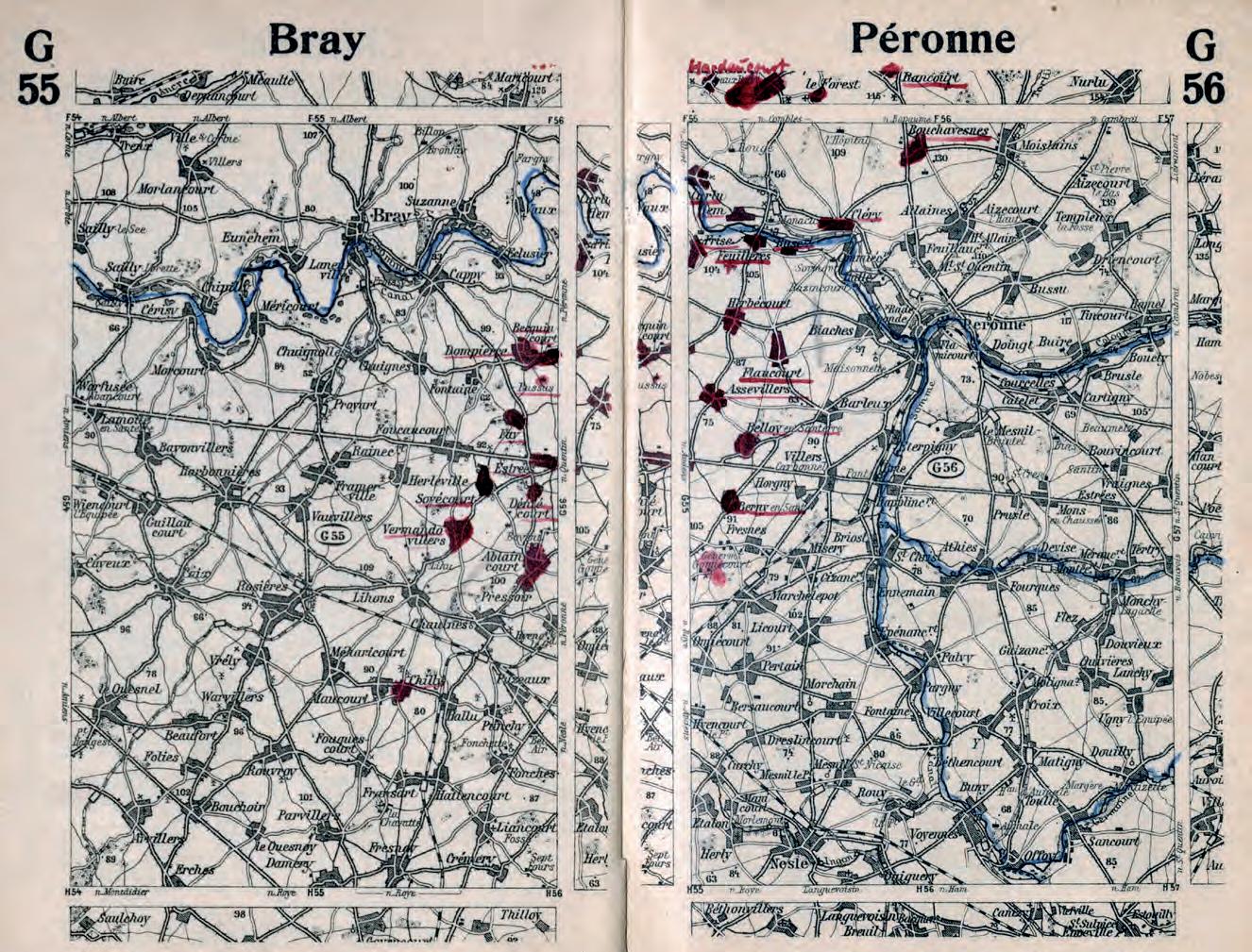
On opposite page: Fig. 10 Index map of the Marsa Taschenatlas vom Westlichen Kriegsschauplatz (Marsa pocket atlas of the western theatre of war), with some maps sheets highlighted by the former owner (Author’s collection)
Above: Fig. 11 Double page depicting the maps on Bray and Peronne, the area of the heaviest fighting in the Somme region in 1916 containing highlighted and additional information of the former owner. (Author’s collection)
106 NAM ANNo 3 (2022), FAscicolo speciAle 2. setteMbre 2022 MilitAry cArtogrAphy
3.2.1 Neuester Kriegs-Atlas, G. Schuh & Cie
The Neuester Kriegs-Atlas published in Munich in November 1914 by G. Schuh & Cie is one of the best examples of how the production of knowledge on the theatres of war opened possibilities to continue business throughout the war. G. Schuh was traditionally a lithographic institution (Lithographische Anstalt), had become well known for producing advertising posters, and owned the Vereinigte Druckereien & Kunstanstalten GmbH, that reproduced the well-known posters of “The Six”, a pre-WWI association of graphic artists already focusing the idea of utilitarian art, later represented by the Bauhaus and were publishers of the then famous political humorous-satirical Kikeriki Kalender. During WWI G. Schuh produced a couple of propagandistic books, e. g., Deutschlands Stolz (Germany’s pride), containing a thorough overview on the German army, navy and air force and their means of warfare, and books on the prehistory of the war illuminated from a strongly nationalist view- point. The seven editions of the Neuester-Kriegs-Atlas differ from those atlases produced by the aforementioned knowledge brands.
The first edition contained a propaganda text that blamed the Entente Nations as warmongers and set the stage for a glorious German victory which the atlas should document throughout the war – and, for when the heroes come home, “they will take the atlas in hand to follow their glorious routes into battle”. The advertising in the Börsenblatt des Deutschen Buchhandels (Fig. 12) underlined the business model of the atlas with the slogan “Zur Massenverbreitung in allen Kreisen geeignet!” (Suitable for mass dissemination in all social groups) and focused on commercial success by offering attractive business conditions.
With a selling price of 20 Pfennig, the atlas was remarkably cheap regarding the comprehensive content and quality. Produced in form of a magazine (22 x 28 cm, with spine stitching, colored lithographics), it contained 10 maps of different origin25. The first four roughly covered the western theatre of war, with two railway maps of Belgium and Northeastern France and two surrounding area maps of Antwerp and Paris. Most of them are rather cheaply (re-)produced railway maps, that were common for contemporary travel books, with inconsistent spelling of placenames and hand-drawn signs for fortified places. The map of Antwerp and
25 Comparing typeface, content, graphical visualization of scale, colouring.
Eric Losang • War atlases of World War I Germany 107

Fig. 12 Advertising of the Neuester Kriegs-Atlas, in Börsenblatt des Deutschen Buchhandels (Courtesy: Digitale Sammlungen der Sächsische Staatsbibliothek, Dresden)
108 NAM ANNo 3 (2022), FAscicolo speciAle 2. setteMbre 2022 MilitAry cArtogrAphy

Fig. 13 Map of Antwerp and environs taken from the 1st Edition of the Neuester Kriegs-Atlas (Author’s collection)
environs especially shows the poor addition of information as the colored water bodies overprint the placenames (Fig. 13).
The assembly and sequence of the first edition closely followed the given strategic war goals, thus creating the narrative of the atlas:
A) Short term success in the west: maps of Belgium (1), Northern France (2), Antwerp reflecting its strategic importance (3), Paris as final target (4),
B) After success in the west, moving troops to the east: map of Central Europe, connecting the theatres of war (5,6),
Eric Losang • War atlases of World War I Germany 109
C) Controlling the efforts of England: maps of the coastline of the North Sea (7,8),
D) Final success on the eastern front: map of the German-Austrian border to Russia and of the Balkans (9,10).
This is a blueprint for most first editions of war atlases that, according to successive political and strategic events, later needed to be supplemented or replaced by more detailed maps. The second edition of the Neuester Kriegs-Atlas published in June 1915 was a completely new edition that took account of the entry of Italy into the war on the side of the Entente (23rd May 1915). One obvious addition was a notice on the cover: that this edition was not only an improvement on, but a continuation of, preceding editions. Thus, “who wanted to seamlessly follow the war events needs to buy the all editions” (Neuester Kriegs-Atlas, 2nd edition: cover page).
The main changes in the second edition (that became standard until the sixth) was engaging an author responsible for text passages (the former officer Leutnant A.D. Heinrich Hacke, who had already authored three publications for G. Schuh, presenting a thorough overview on the German military forces), and the improvement of maps in visualization mode and content (e. g., added colored hachuring). Large text passages, in propagandistic style, explained contexts and events. Again, the atlas followed the main events:
A) The building of a new theatre of war: double-page overview map of the Italo-Austro-Hungarian borderline,
B) The battle’s advance in the East, April – June 1915: maps of Kurland and of the Carpathian Mountains,
C) The battles in the Forest of Argonne and the Vosges, September 1914 – June 1915: one overview and three detailed maps of the battle grounds,
D) The Battles of Ypern/Ypres, October 1914 – May 1915: large scale map of Ypern and surroundings.
This can be taken as a blueprint for many second and following editions of war atlases. They mainly started with small-scale overview maps (texts) on the newly added theatres of war, followed by status quo reports on the ongoing fights accompanied by improved large-scale maps of important areas. Although the Western front line was of main public interest, its change into a static battle without larger territorial gains didn’t need any more overviews but, instead, improved and
110 NAM ANNo 3 (2022), FAscicolo speciAle 2. setteMbre 2022 MilitAry cArtogrAphy
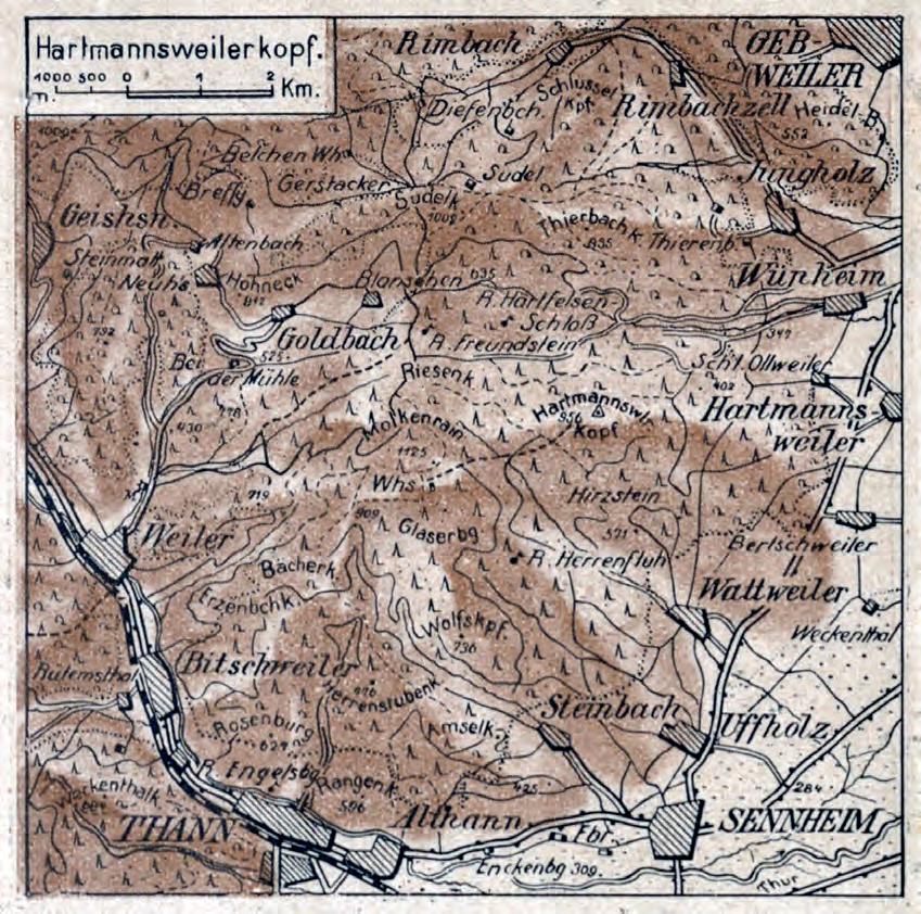
Fig. 14 (above and on opposite page) Maps of the front line at Hartmannsweilerkopf and Reichsackerkopf taken from the 2nd edition of the Neuester Kriegs-Atlas (Author’s collection)
more detailed maps of locations of battles. Figure 14 includes two detailed maps of the second edition of the Neuester Kriegs-Atlas showing the static front line at Hartmannsweilerkopf and Reichsackerkopf, places that frequently changed hands in 1915. The static war situation, especially along the Western and Eastern fronts, led to more detailed descriptions of the whole variety of places militarily involved or politically on the brink of becoming just another theatre of war.
Eric Losang • War atlases of World War I Germany 111

The 4th and 5th editions still had textual explanations and now contained overview maps of the eastern theatre of war and the colonies. The 7th (last) edition was published in November 1916; supply problems caused it to be printed on low quality paper and contained no texts. The spatial focus was very narrow, reflecting Romania’s entry into the war on the side of the Entente with 13 maps of Romania and two of Macedonia, all of them typical regional railway maps with hachures.
112 NAM ANNo 3 (2022), FAscicolo speciAle 2. setteMbre 2022 MilitAry cArtogrAphy
3.2.2 Other war atlases
Different publishers entered the market in 1915 with similar atlases and multiple editions. Unfortunately, a more detailed overview needs to be part of a comprehensive research project as libraries, collections and archives often just provide single editions. These rather short-lived publication projects often can’t be found in equally rare, or incomplete, publishers’ archives. For example, the Neuester Kriegs-Atlas – because of the high paper quality of the first six editions – can be taken as blueprint for the classification of the following atlases of non-traditional map producers that is far from being complete.
Among the list of atlas producers the author could also identify short-term founded publishing ventures, such as the Kriegsverlag A. G. in Berlin, that produced booklets on different aspects of the war (e.g., Deutsche Kriegsgedichte 1914 – German war poems) and, of course, atlases (Taschen-Atlas der Kriegsschauplätze) that in the first place were distributed to the front lines, where the need for spatial information was as important as back home.26
Thus, these booklets became valuable notebooks or diaries of personal war biographies and helped soldiers locate their own whereabouts. The famous Taschen-Atlas der Kriegsschauplätze was produced in different editions with the total run exceeding 1 million exemplars in 1916. All editions identified by the author contained uncolored maps of different content quality, mainly edited by W. Hinkelmann. Besides being ordered by several troop units, the handy and cheap (between 10 and 25 Pfennig) atlas was distributed in schools, factories, offices of public authorities, military hospitals, hospitals and sanatoriums (Taschen-Atlas 1917, cover page). As intended by the publishers, it became the “Volksatlas des Krieges” (People’s atlas of the war). The different editions contained no text or statistics. The uncolored maps presented as many placenames as possible (Fig. 15) and included railway lines, rivers and water bodies. Orographic information was rarely used, only in detailed maps of mountainous combat zones like the Isonzo front line (Fig. 16).
On opposite page: Fig. 15 Typical uncolored map with a high density of placenames taken from the 2nd edition of the Taschen-Atlas der Kriegsschauplätze (Author’s collection)
26 KANN, 2021, p. 218.
Eric Losang • War atlases of World War I Germany 113

114 NAM ANNo 3 (2022), FAscicolo speciAle 2. setteMbre 2022 MilitAry cArtogrAphy

Eric Losang • War atlases of World War I Germany 115
Of course, there are several more or less successful war atlases produced by different publishing houses, newspapers and printing companies lacking a cartographic background. However, the above examples show a generally valid pattern, in terms of production and visualization modes, that resembles the war atlases produced during the Spanish-American War in the US, with cartographic companies recycling their existing materials in licensed war atlases (Cram, Rand McNally) and the ‘yellow press’ trying to inform the people with cheaply produced (wax-engraved) map booklets.
3.3 A short reflection on German war maps
As described above, traditional map and atlas producers took the opportunity to supply the widening user group with highly sophisticated (information scope, presentation quality) depiction of the current and future theatres of war. Their intention of reusing their high-quality pools of maps and graphics, as well as their publishing techniques, experience and connections already having a high reputation, can also be identified with the producers of high quality (regional) war maps, like Flemming, Ravenstein or Perthes often at the same price for one map as for one of the above-mentioned atlases. The first “war map” to appear was already advertised on 4th August – one day after declaration of war on France – in the Börsenblatt des Deutschen Buchandels. Professor von Liebenows Kriegskarte von Europa (War map of Europe, 1:2 000 000), was a thorough copy of the “Eisenbahn u[nd]. Reisekarte von Mitteleuropa” (Railway and Travel map of Central Europe, 1:2 000 000) regularly updated and published by Gea Publishers since 1879 (BDB, 178, 4 August 1914, p.9). Flemmings war maps of the western and the eastern theatres of war followed on 7th August, also thoroughly based on the railway maps produced by the publisher based in Glogau (BDB 181, 7 August 1914, p.1). Map series like Flemmings 10-map series “Flemmings Große Spezialkarte vom belgischen und französischen Kriegsschauplatz” (10 sheets, scale 1:320 000) often were produced to be part of a map set: that in the case of Flemming could later be stored in a collector’s box (Fig. 17) containing the whole series of 45 maps. Those maps had been very popular and were often used in educational contexts and, regarding their price, a typical product for the bourgeois middle class.
116 NAM ANNo 3 (2022), FAscicolo speciAle 2. setteMbre 2022 MilitAry cArtogrAphy
4 Instead of conclusion
The outlined examples of war atlases produced in Germany during WWI are only a sample of what spatial knowledge media was produced to answer the demand for information about the geographic characteristics of the theatres of war by people at home and in the trenches.
For traditional knowledge media producers, this opened the chance to re-use (recycle) already existing materials, e. g., from recently published atlases and encyclopedias or simply rebranded products (such as medium-scale travel maps) to tap into new buyer groups. The atlases of traditional map producers were high quality products with thoroughly investigated content and visualization modes, that were contemporary state of the art. Unfortunately, the events of the war after summer 1915 only produced large loss figures rather than significant territorial changes. This left the demand of the saturated market for small-scale maps to fall significantly and the production of this type of war atlases declined after 1916.
More sustainable was the market for ready-made, detailed information on the battlefields. This led to the production of rather cheaply produced and affordable war atlases for the masses, depicting geographic information taken from unnamed sources (often pre-war railway or travel atlases) and focusing the depiction of placenames mentioned in the news. The maps often lacked a uniform representation and their sequence in an atlas was mainly driven by the importance of the respective war zone in the newspapers. They became the ‘little geographic helpers’ of the war, enabling people back home to identify the whereabouts of their loved ones and for soldiers in the trenches to find their own location. Interestingly, only two of these atlases described contained a gazetteer and only some provided a table of contents – both indispensable parts of standard atlas productions.
Note
The author started collecting German war atlases some years ago to follow the centenary anniversaries of WWI events. What started as a small bookshelf steadily grew but is still far from being complete. Poor paper quality of the post1915 atlases didn’t help to preserve them over time, even in library collections. Moreover, the archives of several publishing ventures were lost during WWI and WWII. Some newly digitized sources such as the Börsenblatt für den Deutschen
Eric Losang • War atlases of World War I Germany 117
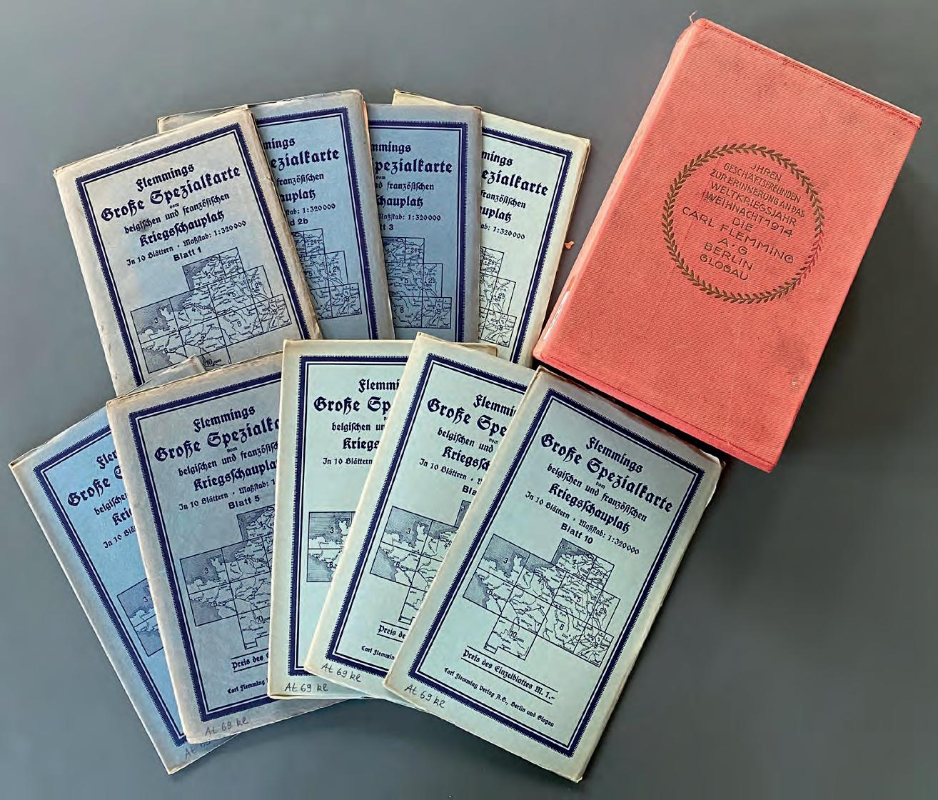
Fig. 17 A loose-leaf atlas? The collector’s box and maps from the series Flemmings Große Spezialkarte des Krieges (Courtesy: Leibniz Institute for Regional Geography)
Buchhandel, or historic geographic journals containing literature reviews, might help to fill the gaps and permit a more complete characterization of war atlases as history-driven documents.
118 NAM ANNo 3 (2022), FAscicolo speciAle 2. setteMbre 2022 MilitAry cArtogrAphy
References
James akerman, « From Books with Maps to Books as Maps: The Editor in the creation of the idea », in Joan Winerals (ed.), Editing early and historical atlases. Papers given at the 29th annual conference on editorial problems, University of Toronto 5-6
November 1993, University of Toronto Press, Toronto, 2016, pp.1–48. Jeremy Black, Maps of War. Mapping Conflict through the Centuries, Conway, London, 2016. BDB - Börsenverein für den Deutschen Buchhandel (ed.): Börsenblatt für den Deutschen Buchhandel, Volumes 1914-1918, accessible online: https://digital.slub-dresden.de Jürgen esPenhorst, Petermann’s Planet, Volume 1: The great Handatlases, G. R. Crossman (ed. and translated), Pangaea, Schwerte, 2003. Marcus GREULICH, « Ideological Changes in Ethnic Atlas Mapping of East Central
Europe During the Twentieth Century», in Elri LIEBENBERG, Imre DEMHARDT and Soetkin VERVUST (eds.), History of Military Cartography, Springer, 2016, pp. 213–229. Hermann haack, « Geographischer Literaturbereicht », Geographischer Anzeiger 18 (1917), pp. 44–52. Oliver kann, Karten des Krieges. Deutsche Kartographie und Raumwissen im Ersten
Weltkrieg, Paderborn Ferdinand Schöningh, Leiden, 2020. Thomas keiderling, F.A. Brockhaus: 1905-2005. Mannheim, Bibliographisches Institut & F.A., Brockhaus, 2005. Eric LOSANG and Imre DEMHARDT, « Change of Sovereignty and Cartographic Advance: Cartographic Implications of the Spanish-American War of 1898 », in Mirela ALTIĆ, Imre DEMHARDT and Soetkin VERVUST (eds,) Dissemination of Cartographic Knowledge, Springer, 2018, pp 99–128. Mark monmonier, Maps with the news. The Development of American Journalistic
Cartography, University of Chicago Press, Chicago, London, 1989. Ferjan J. ormeling, « Atlases », in Bengt rysted B., Ferjan ormeling (eds.) The World of Maps, International Cartographic Association, Stockholm, 2014. Denis Wood, « Pleasure in the idea. The atlas as narrative form », Cartographica 24/1 (1987), pp. 24–46. David WoodWard, The all-American map. Wax engraving and its influence on cartography, University of Chicago Press, Chicago, 1977.
War Atlases
Atlas zum Kriegsschauplatz, Verlag des Bibliographischen Instituts, Leipzig, Wien. Four editions between 1915 and 1917 with slightly changing sets of maps could be identified. All maps are taken from pre-war editions of the Meyers Konversations-Lexikon.
Some maps have been reworked to contain different sets of secondary maps.


