
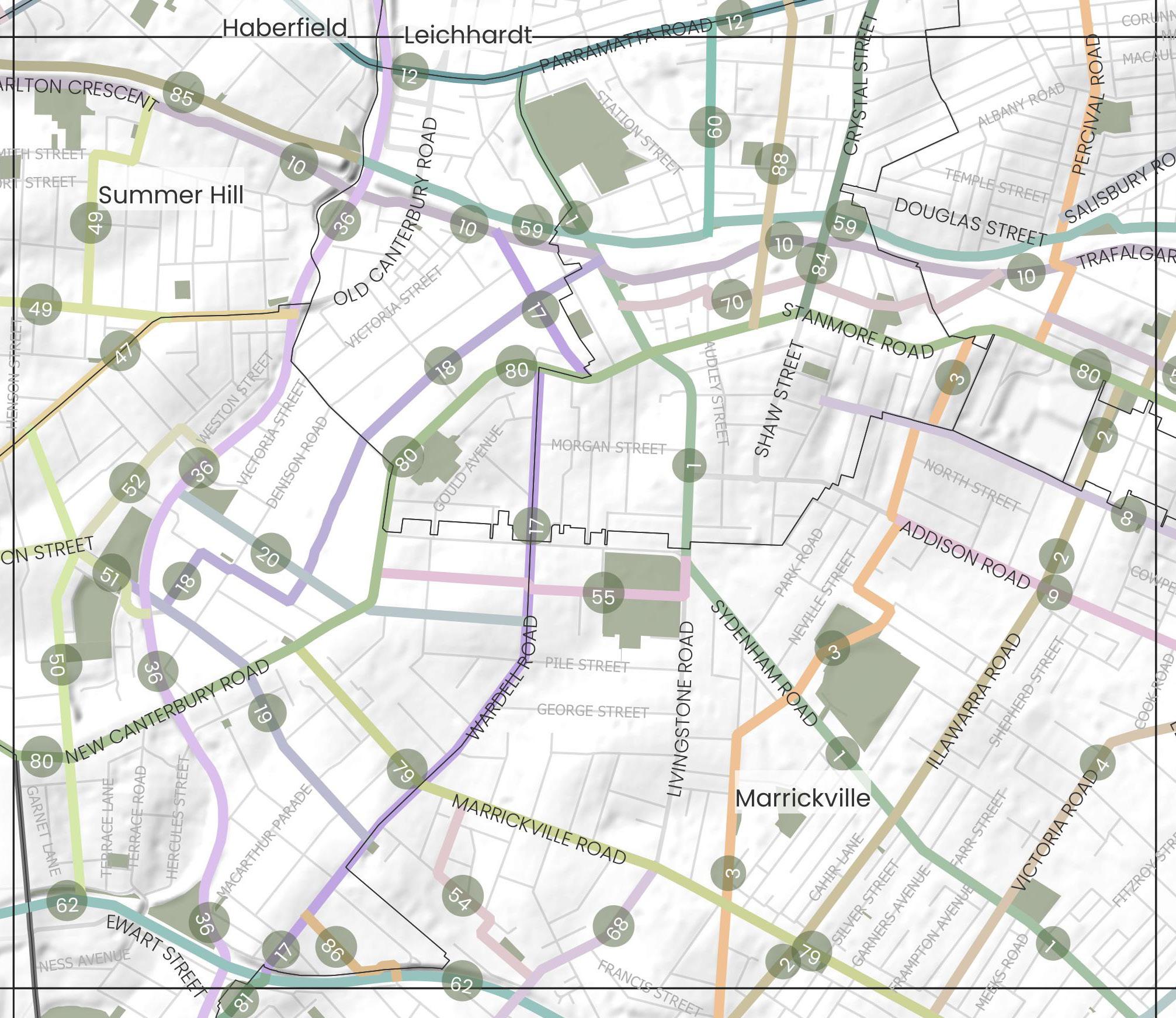
Precinct 5

Blue-Green Grid Links

1 Petersham Park to Sydenham Station via Marrickville and Henson Park
2 Marrickville Peace Park to Montague Gardens
3 Petersham Road to Percival Road
4 Victoria Road to Newtown Train Station
8 Newington Road from Albert Street to Enmore Road
9
10
12
17
18
Precinct 5 Continued
Relevant Projects and Responsibility
Dulwich Hill Village Master Plan (under development)
Ongoing, Inner West Council
Marrickville Town Centre Master Plan (under development)
Ongoing, Inner West Council
GreenWay Missing Links project
Ongoing, Inner West Council
Cycling Strategy and Action Plan
2023, Inner West Council
Dulwich Hill Parklands Master Plan
2020, Inner West Council
GreenWay Master Plan
2018, Inner West Council
Leichhardt Native Revegetation & Biodiversity Management Plan
2017, Inner West Council
Parramatta Road Corridor Urban Transformation Strategy (PRCUTS)
2016, TfNSW DPE/Inner West Council
Western Channel Subcatchment Management Plan
2014, Inner West Council
Eastern Channel North Subcatchment Management Plan
2013, Inner West Council
GreenWay Biodiversity Strategy
2013, Inner West Council
GreenWay Revegetation and Bushcare Plan
2011, Inner West Council
Marrickville Biodiversity Strategy
2011, Inner West Council
GreenWay Flora and Fauna Literature Review
2010, Inner West Council
Riverside Crescent Subcatchment Management Plan
2010, Inner West Council
Tennyson Street Subcatchment Management Plan
2009, Inner West Council
8
1
Marrickville,
Link connects major recreational open spaces traveling from Petersham Park at West Street and down Livingstone Road to Marrickville Park then along Sydenham Road passing Wilkins School, Henson Park and Wicks Park before arriving at Sydenham Station. The link travels busy streets, mostly residential with pockets of commercial and industrial at the Sydenham end.
The link could see improvements in pedestrian and cycling infrastructure to make the north-south connection safer but to also offer better connections to major east-west cycling routes and the rail line. West Street is well serviced with existing tree canopy. This should be retained and enhanced so as encourage and increase areas of habitat for native flora and fauna. Areas of industrial character along Sydenham Road see a reduction in canopy cover and could benefit from increased tree planting to mitigate urban heat and support urban ecology.
Marrickville,
A key existing cycle way that runs from the Cooks River up to Montague Gardens via Marrickville Town Centre and number of schools including Ferncourt Public School and Newington College. The link along Illawarra Road is busy. The streets are predominantly residential in character, with some commercial and with a good amount of tree canopy.
Key existing cycle route that connects Marrickville Town Centre to Parramatta Road via Marrickville High School, Henson Park, Newington College, Stanmore Train Station and Town Centre, and Weekly Park. The link is mostly residential in character.
A busy thoroughfare, the route connects parts of Marrickville through to Newtown predominantly following Victoria Road and Enmore Road. Key destinations along the link include the Factory Theatre, Enmore Park and Enmore Theatre. The link changes from residential to industrial then commercial along the route, with varying canopy cover.
A residential link, with significant tree planting and shade. It contains an existing cycle way linking Enmore Road to the backstreets of Petersham but with no separated cycle path. It passes Newington College, Newington Road Playground and leaves you close to Marr Playground in Petersham.
This route has a mix of commercial, industrial and residential character. It connects Enmore Park through to Addison Road Community Centre, an important community and cultural institution for the Inner West.
The route has an existing strong tree canopy presence with room to expand, and the community wish to see increased planting for shade and amenity. Opportunity exists to raise pedestrian crossing through the high pedestrian activity area. The community identified Illawarra Road as good north-south connection. However, due to topography and heavy vehicle presence it would need improvements to be a safe option for active transport such as traffic calming, signage and line markings.
Parts of this route have decent canopy coverage, whilst some provide wide road reserves that would suite additional greening and more space for pedestrians. The link could benefit from additional crossings and widened footpaths.
Additional canopy cover and street planting would be a key opportunity for this link which lacks shade along parts of Victoria Road. The link is an important connector from Marrickville to Newtown and on to the city with the opportunity to improve cycleways, footpaths and crossings and measures to create a safer environment for active transport. The community have suggested improving the crossing at King, Wilson and Eliza Street in Newtown. The link hosts some of the Inner West's most iconic cultural institutions providing an opportunity for public space activation and cultural installations.
The footpaths are narrow, as is the street, creating obstacles for pedestrians. The cycleway is valued, however the steep slope, poor road condition and school drop off's at Newington College create a hazard for cyclists. This link would benefit from reduced speed limits, separated cycleways, footpath improvements and other safety measures at drop off points to protect cyclists.
The route experiences some flooding and has limited canopy cover at points so could benefit from increased tree planting, landscaping and Water Sensitive Urban Design features. Opportunities exist to improve Addison Road for cyclists and pedestrians, namely at the intersection with Enmore Road, by improving sidewalks and intersections. A key feature of the link is the Addison Road Community Centre, which provides ample opportunity to provide public art and cultural activation in public spaces.
The link provides direct routes between train stations and opportunities for better connection to the GreenWay. There is also opportunity to identify a clear user journey along the line and create more crossing for both pedestrians and cyclists. Better cycleway connections, widened footpaths and tree planting for shade are other identified improvements along this route.
Parramatta Road is a key state road which traverses the Inner West east to west connecting the CBD to Western Sydney. The 6 lane road is mostly commercial in nature, and has limited street trees. There are multiple points of interest along the link, including half a dozen entertainment venues and pubs, Ashfield Park, the GreenWay, Fort Street High School and primary links into surrounding suburbs.
The link continues from link 81, Wardell Road from Cooks River to Dulwich Hill Station. it connects the train stations to each other passing Petersham Public School and St Maroun's School and College. Wardell Road is a busy road, predominantly residential and contains many significant street trees.
Parramatta Road has opportunities to deliver significant improvement in tree canopy coverage and street tree planting for cooling. The link could deliver widened footpaths, improved crossings for pedestrians and cyclists alike, along with dedicated cycleways and improved public transportation offering. The link is subject to both local and state strategies that provide opportunity for public domain and access uplift, including the Paramatta Road Corridor Urban Transformation Strategy, Tech Central, and the WestConnex Camperdown Dive Site which holds potential to deliver temporary and long term value to the Blue-Green Grid.
18 Johnson Park to Petersham Public School
19 Arlington Light Rail Stop along Beach Road to Wardell Road Dulwich Hill
Hoskins Park to Wardell Road along Pigott Street and Herbert Street
Connects the grid to Arlington Light Rail Stop along The GreenWay. Mostly residential in character, with a major crossing at New Canterbury Road at the Dulwich Hill shops. Established native planting along Beach Road.
36 The Cooks to Cove GreenWay
and active transport corridor
1
A corner of Johnson Park is set aside for rewilding and natural habitat which is highly valued and should be preserved and maintained. Opportunities exist to create a stronger active transport link including separated cycleways, improved footpaths, and traffic calming measures to increase pedestrian safety. 1
Opportunities to provide street tree planting for urban cooling at traffic lights with New Canterbury Road as well as traffic calming measures to create a safe environment for pedestrians and for the use of active transport along this link. 1
As a major environmental and recreational link for the Inner West, the link continues to offer the community a diverse and inclusive recreation space with opportunities for - public art and cultural activation in public spaces and parks
- Providing safe, accessible footpaths and cycleways
- Recognising and celebrating Aboriginal and Torres Strait Islander culture and histories in significant locations as they are identified along the link
Major improvements and opportunities for this existing ecological active transport corridor are outlined within the GreenWay Masterplan. The GreenWay Masterplan includes proposals for $57 million of works to be implemented over the long term. Around $45 million of high priority works are anticipated to be completed in 2025. Works in progress include:
- high voltage feeder relocation to the Waratah Mills Light Rail Station (required to enable construction of the paths and an ecological restoration of parts of the corridor
- Bay Run path and lighting upgrade
- in-corridor works involving the construction of a shared path, lighting and landscaping
Community feedback identified the need for improved crossings over Parramatta Road at Taverners Hill. In April 2023 design plans were exhibited detailing options for addressing key missing links and connections which could delivered to provide safer, more accessible connections along the entirety of the GreenWay link.
A section of the link is included within the Parramatta Road Corridor Strategy Phase Planning Proposal. Future uplift may provide opportunities for improved public domain and recreation improvements.
1 1 1 1 1
47 Canterbury Road and Old Canterbury Road
Summer Hill, Hurlstone Park, Ashfield
A north-south link connecting Yeo Park to the Summer Hill Flour Mills development at Edward Street.
There are opportunities to provide improved pedestrian and cycle infrastructure along this link. An improvement identified by the community is the intersection of Old Canterbury Road and Edward Street which connects to the GreenWay cycleway along Weston Street. Yeo Park could also accommodate delivery of more trees to increase canopy cover and amenity for park users.
49 Victoria Square Reserve to Summer Hill Village Summer Hill, Ashfield
Link runs along Junction Road connecting Victoria Square Reserve to Summer Hill Village. Link also connects with link 47 on Old Canterbury Road connecting in with high density residential development within the Summer Hill Flour Mills site, Lewisham Train Station and Lewisham West Light Rail Stop.
Improvements could mostly consider the provision and improvement of safe, accessible footpaths and crossings to key destinations within this link. Segments of the link including parts of the Summer Hill Village have limited canopy cover and would benefit from additional tree plantings to increase shade and general amenity for pedestrians and other users of this link and key destination.
50 Constitution Road to The Parade via Union Street Dulwich Hill
Link that connects St Paul of the Cross Catholic Primary School to JF Laxton Reserve and Arlington Oval. The link is on the outskirts of a biodiversity area.
Sections of the link with wide road reserves present the opportunity for increased greening through verge and private garden plantings. Underutilised green space running along The Parade could be enhanced with additional planting of diverse vegetation to act as a natural habitat for native flora and fauna. Improvements should look to provide safer pedestrian and cycle infrastructure especially surrounding the intersection at New Canterbury Road.
Link connecting Yeo Park and Arlington Light Rail Stop along Arlington Street and Constitution Road. The link includes connections to Johnson Park and Arlington Recreation Reserve.
Short link providing connectivity to the Waratah Mills Light Rail stop from Windsor Road along Weston Street.
The link connects Marrickville Road and Livingstone Road via Pine Street and Hollands Avenue. Harney Street has fantastic established greenery and Ness Park includes a fenced playground suitable for toddlers. Ness Park can be accessed from Hollands Avenue and Pine Street. St Marouns School can also be accessed just off Pine Street.
The link services as a direct connection to a number of recreational open spaces and transport infrastructure. Link opportunities should consider providing safe, accessible footpaths and crossings and where possible providing additional tree plantings and landscaping to enhance the amenity provided to pedestrians along the route.
Improvements could involve increasing greening along the verges and increased tree canopy cover along Windsor Road.
1
55 Yule Street and Porter Avenue Marrickville
56 Cavendish Street Stanmore, Enmore
57 Salisbury Road Stanmore, Camperdown
1 1
1
1
1 1
59 Northern Link of Newtown to Croydon train line
Newtown, Stanmore, Petersham, Lewisham, Summer Hill, Ashfield, Croydon
60 Palace Street Petersham
This link follows the T2 rail line between Croydon and Newtown. The northern side of the rail line does not currently allow for full pedestrian access east - west. This link is aspirational to show the need for increased access to the rail line by daily transport users.
Currently there is no continuous pedestrian or cycle link along the rail corridor. Through the community engagement undertaken for this project, this has been identified as a project opportunity that should be investigated to improve pedestrian and cycle connections east-west across the Inner West. Opportunities along the link should consider improving footpaths, crossings and cycle infrastructure. Rewilding of areas adjacent to the rail corridor in addition to consideration of areas that could accommodate increased tree canopy, verge and private garden plantings should be investigated.
Short link connecting Parramatta Road to Petersham Train Station via Fort Street High School.
Improvements along this link should consider the provision of safe, accessible footpaths and crossings. The amenity of the link could also be improved through the provision of additional vegetation and tree plantings to increase canopy cover and shade along the link.
62 Southern Trainline
St Peters, Sydenham, Marrickville, Dulwich Hill
Link follows the train corridor which runs from St Peters to Dulwich Hill train stations.
Currently there is no continuous pedestrian or cycle link along the rail corridor. Opportunities along the link should consider improving footpaths, crossings and cycle infrastructure. There is some opportunity along this link to increase tree canopy, verge and private garden plantings and to rewild the area along the rail corridor to increase areas of natural habitat for native flora and fauna.
Livingstone Road is a key connector to access many areas of the Inner West. This part of the road connects the Marrickville Town Centre to the Cooks River via a number of local primary and high schools. Parts of the link include a separated cycleway, however this is not consistently provided along the entirety of the link. Possible improvements should look to improve pedestrian and cycle infrastructure and where possible allow for suitable separation of pedestrians, cyclists and vehicles. The link could also benefit from increased vegetation and tree plantings not only improve amenity of the link for pedestrians, but to also enhance and increase wildlife corridors and areas of habitat for native flora and fauna.
Petersham has seen an increase in high density development in recent years. This link seeks to improve access to existing open space within the area for residents to enjoy in neighbouring suburbs. Link opportunities should consider provision of accessible footpaths and crossings and additional tree plantings to improve amenity along this link.
The community has identified a desire for formalised cycle infrastructure to be provided along this link and where possible providing suitable separation of pedestrians, cyclists and vehicles. As the link travels through two major town centres, consideration should also be given to reducing the speed limit to increase safety for pedestrians and cyclists. The link would benefit from increased tree canopy and vegetation to assist with reducing the impacts of urban heat but also improving amenity along the link.
80
New Canterbury Road and Stanmore Road
Hurlstone Park, Dulwich Hill, Lewisham, Petersham, Stanmore, Newtown
Link runs along major roads including New Canterbury Road, Stanmore Road through to Enmore Road. The route connects with a number of town centres including Dulwich Hill and Petersham.
84 Crystal Street Petersham Link from New Canterbury Road to Parramatta Road via Petersham TAFE.
This link will operate as a main active transport connection from the east-west across in the Inner West. Opportunities along this link should look to provide improved cycleways and pedestrian infrastructure, including reduced speed limits and traffic calming where there is high pedestrian activity. Where possible provision should be made for suitable separation of pedestrians, cyclists and vehicle infrastructure. Additional tree plantings to improve shade and amenity along the link is a noted opportunity, particularly within the town centres included within this grid link.
This link has been identified by the community as a key missing active transport connection necessary to better connect the northern and southern parts of the Inner West. Possible improvements to this link should consider improved cycling infrastructure and where possible additional tree plantings and improvements to footpaths and crossings to make the link a safer active transport connection for all users.
86 Kays Avenue West Dulwich Hill
88 Railway Street and Regent Street Petersham
Link
Opportunities along the link should consider improving footpaths, crossings and cycle infrastructure. There is some opportunity along this link to increase verge and private garden plantings and to rewild the area along the rail corridor to increase areas of natural habitat for native flora and fauna.
Small link connecting Kays Avenue West to Albemarle Street over the rail line.
Connection between Parramatta Road and New Canterbury Road via Petersham Train Station.
There is some opportunity along this link to increase verge and private garden plantings and to rewild the area along the rail corridor to increase areas of natural habitat for native flora and fauna.
Opportunities exist to provide safe, accessible footpaths and crossings along this link. Some opportunities may also exist to provide additional tree plantings and encourage verge and private garden planting to improve amenity along this link.