9 minute read
Get out and stay out

DON’T KNOW WHERE TO START?
Let us help you build an itinerary that is sure to check all of your outdoor adventures off your list. https://trip-planner.
visitftcollins.com/
LOST IN SPACE
Cell phone service can be spotty to downright nonexistent in the canyons. Try loading a map of the area on your phone or tablet and then follow the blue dot. Or visit one of our visitor centers for a paper map and directions.
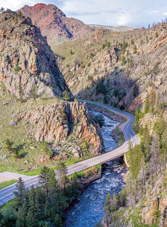
The river and road meet and make their way through the Cache la Poudre River Canyon. SIDE OF THE ROAD
Check your gas tank before you head up the Cache la Poudre Canyon. You can top off at Ted’s Place where Hwy 14 leaves Hwy 287. Options are few and far between after that.
Get out PEOPLE LIKE TO GET OUTDOORS HERE all year round. It’s a lifestyle thing. In town, enjoy a stroll around a lake or play in the river at the new water park near College Avenue and Vine Drive. Take the kids to a splash park to cool down. And your four-legged friend is welcome at many places, too.and stay out Make Fort Collins your base camp. You’ll find adventure and solitude at the many open spaces, natural areas and parks. So get out and stay out…doors, that is. Discover your place in the sun. You’ll just feel better.
Walden
Medicine Bow-Routt National Forests Arapaho and Roosevelt National Forests

Fort Collins
Loveland
34
40
Estes Park Grand Lake
287
36
Boulder
14
Greeley
85
THE BIG SCENIC DRIVE-AROUND
Leave early. Drive time is six hours and you’re going to want to stop, stretch and look around…a lot!
Drive up Hwy 34 west of Loveland into Rocky Mountain National Park then up and over Trail Ridge Road (open summer to early fall) to Granby. Head north on Hwy 125 to Walden and then turn east on Hwy 14 over Cameron Pass and down the Cache la Poudre Canyon. Can be done in reverse.
The Cache la Poudre Canyon
It’s Wild and Scenic up here— Colorado’s only river with that national designation, in fact.
Turn west up Hwy 14 off Hwy 287 at Ted’s Place and follow the designated scenic byway to:
• Pick a trail, any trail—
Stretch your legs, free your mind and breathe that pine air! • The Mishawaka—Best deck...ever. Grab a bite and a beverage at this idyllic eatery and concert venue. • Cameron Pass area—Inhale, exhale. Go for a hike.
Check out the Noghu
Crags and the Moose Museum on the west side. Next, head north up the switchbacks on County Road 69 by Rustic toward Red Feather Lakes. Later, head back to town down Red Feather Lakes Road toward Livermore and Hwy 287.
• Shambhala Mountain
Center—Follow in the footsteps of the Dalai
Lama, who visited here in 2006, to the Great Stupa of Dharmakaya. Visitors are welcome. • Red Feather Lakes area—In town, grab an ice cream cone and poke around the shops, then find some mountain fun in
Roosevelt National Park.
Take Deadman Road to the Deadman Lookout and see captivating mountain ranges in all directions.
Rocky Mountain National Park, Emerald Lake Trail
ROCKY MOUNTAIN NATIONAL PARK
THE TRUE COLORADO ROCKY
MOUNTAIN HIGH is just an hour up the hill from Fort Collins. Follow the Big Thompson River on Hwy 34. Trail Ridge Road—With panoramic 360-degree views, TRR is the highest paved highway in the country. Pop on over to
Grand Lake. The road opens in early summer and closes in the fall. Rocky Mountain National
Park—Discover elk, big horn sheep, spectacular peaks, quiet lakes, inviting trails, and more.
DRESS FOR SUCCESS
No matter what time of year, be prepared for abrupt changes in the weather. Sunshine can turn to afternoon rain and wind, or snow. Pack layers of clothing that you can put on and remove as needed. A rain shell is always a good idea as is a billed cap, sunglasses and sunscreen.
Outings inside the city
You don’t have to go far to find some open space. There’s plenty of it right here in town. A great tool is the Natural Areas Finder at www.fcgov.com/ naturalareas/finder.
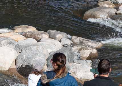
Try out these excursions. Kayak in Old Town—Catch an eddy in the River District at the new Poudre River
Whitewater Park. Walk or pedal a paved trail—
Explore the Cathy Fromme
Prairie Natural Area, Spring
Creek Trail or the Poudre
River Trail. Throw a disc—Choose from two 18-hole courses:
Edora or Aggie Greens Disc
Golf Course. Splish, splash—Jump into the City Park Outdoor Pool or get doused by dancing water spouts at Spring
Canyon, Oak Street Plaza,
Old Town Square and Fossil
Creek parks. Visit a garden—Stroll through hundreds of different blooms at the CSU Flower
Trial Gardens and expanded
Gardens on Spring Creek. Colorado State University Flower Trial Gardens— pack a lunch and discover exotic and native plants, flowers, and shrubbery growing side-by-side in this botanical wonderland.

#LoveFortCollins I just love River Bend Ponds, a lovely peaceful place to hike.
—Laurie M. Via Visit Fort Collins social media

Play a round of golf—swing those sticks on three city courses… open almost year ‘round. fcgov.com/golf.
EVERYONE GETS TO PLAY
One of the most popular playgrounds in town is at Spring Canyon Park on the west end of Horsetooth Road. Inspiration Playground is made to accommodate wheelchairs, walkers and support braces encouraging kids of all abilities to play and interact.
SO DOG-FRIENDLY
Fort Collins is a dog town. If you brought yours, here are a few things you should know. First, the leash law is in effect and enforced. Second, you’ll see bags available for waste pick up. And finally, let Rover rove at one of the three dog parks in town: Fossil Creek (south end), Twin Silo Park (south end), Spring Canyon (midtown), and Soft Gold (north end). And check the signs. Some trails prohibit dogs all together, some require Rover to be on a leash, and others are fine places to let her run wild and free.
You could spend a lifetime getting to know the trails in and around Fort Collins. For hiking, trails are rated as Easy, Moderate or Difficult. These rankings typically are related to how much elevation you gain and lose and how technically difficult the trail is.
While enjoying the backcountry, remember to leave only footprints and take only memories and photos so that those who follow after you can have the pristine experience that makes these mountains the beautiful refuge that they are.

GREYROCK SUMMIT
Cache la Poudre Canyon Hwy 14. Park at main parking lot. Popular trail with switchbacks to an exciting finish up Grey Rock. To make a loop, take the Grey Rock Meadows trail one direction.
HORSETOOTH FALLS AND HORSETOOTH ROCK
Horsetooth Mountain Open Space. Park at main parking lot. Pass a waterfall through woods and meadows on your way to the top of the iconic Horsetooth Rock.
COYOTE RIDGE TO RIMROCK OPEN SPACE
Coyote Ridge Natural Area. Foothills meets the plains. Gorgeous views to the west from the top of the trail. No dogs on this trail.
TOWHEE LOOP
Soapstone Prairie Natural Area. Park at the north parking lot. Hikers-only trail. Great views with mule deer and a variety of birds.This trail has an easy/moderate rating.
WELL GULCH NATURE
Charles A. Lory State Park. Park at Eltuck Group Picnic Area A little something for everyone on this self-guided tour through several ecosystems with information along the way.
POND AND RIVER MEANDER
Riverbend Ponds Natural Area. Park at any of three trailheads. Flat trails with loop options. More than 200 species of birds feed, nest and migrate through this area. DIFFICULT 6.3-mile out-and-back or 7.1-mile loop
MODERATE 5.7-mile loop
EASY 1.8-mile loop
HIKING ESSENTIALS
Having these items on-hand will make any amble or ramble more enjoyable. Use binoculars for wildlife watching, a reuseable water bottle to stay hydrated, and a generous application of sunscreen to protect your skin from sunburn.
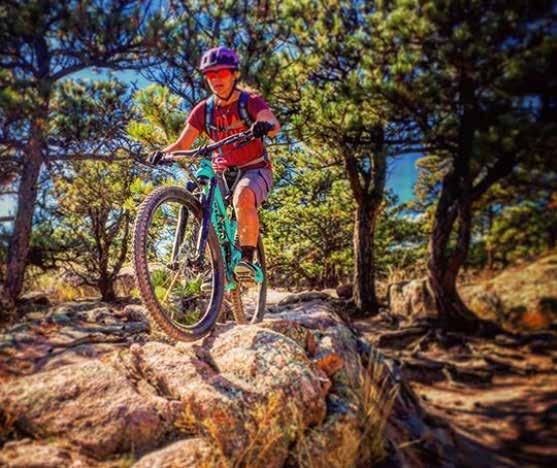

@frontrangerideguides
LOG ON TO GET GOING
Log onto www.mtbproject.com for trail information or download the MTB Project app for quick and easy access to rides both in and around Fort Collins. CHOOSE YOUR RIDE: steep and technical, smooth and flowy or somewhere in between. It’s a pedalers paradise out here. Mountain bike terrain is graded using a system similar to ski decents. Green dot for easy; Blue triangle for moderate; and Black diamond for difficult. All rides are part of a trail system and can be extended or modified.
EAST & WEST VALLEY TRAILS AND SOUTH VALLEY LOOP
Charles A. Lory State Park. Recommended to park at Timber Group Picnic area l EASY 6.9-mile loop trail. Rolling single track with few obstacles through beautiful meadows.
RUBY WASH—CHEYENNE RIM LOOP
Start at the Red Mountain Open Space trailhead. n MODERATE 12-mile nontechnical loop through astonishing scenery.
FOOTHILLS-MAXWELL LOOP
City of Fort Collins Maxwell Natural Area and Larimer County Open Space. Park at Maxwell Natural Area parking lot. u DIFFICULT 5.9-mile loop with an out-and-back start. Technical, ridable single track with good flow and great views of Horsetooth Reservoir and the parks beyond.
Gravel road rides
GRAVEL RIDES ARE THE BEST: Enjoy anything from easier mountain bike trails to chunky gravel to smooth-as-glass roads. Gravel roads offer quiet, scenic terrain with little to no traffic, and the Fort Collins area is full of them.
Head to www.gravelgraceland.com to get more ideas in the region. Whitney and Zack Allison, owners of Bike Sports at www.bikesportsco.com, provided the gravel road content and offer gravel road tours.
RIST CANYON BOTTOMS (19 MILES)
Explore the Poudre River Trail and various dirt trails heading west to Rist Canyon with a break at Me Oh My Pie in LaPorte. Head back into town via Bingham Hill. www.gravelgraceland.com/easy-routes/ rist-canyon-bottoms
CEMENT PLANT + TAFT DIRT (30 MILES)
Over 1,000 feet of climbing takes you through a series of dirt roads, around past Ten Bears Winery, and back to town. www.gravelgraceland.com/easy-routes/ cement-plant
GRAVEL GRACELAND RED FEATHER LOOP (47 MILES)
Get ready for 5,400 feet of climbing through breath-taking mountain country. Then stop into Red Feather Lakes for a cream soda or scoop of ice cream. www.gravelgraceland.com/medium-routes/ stronggravel-graceland-red-feather-loopstrong
Largest INDOOR Flea Market In Northern Colorado

Over 80 Dealers With Something For Everyone!

OPEN DAILY 10 - 6
6300 South College Avenue | 970-223-9069 foothills-flea-market.business.site