
26 minute read
Hurricane


HURRICANE SEASON JUNE 1 – NOVEMBER 30
Hurricanes are the only natural disasters with their own names. Audrey, Betsy, Camille, Hazel, Gilbert, Andrew, Katrina and Gustav–each evokes its particular image of disaster. Hurricanes are the same in vital ways; like people, each has its own personality.
Names seem appropriate because we come to know hurricanes before they strike, unlike earthquakes, which hit without warning. Tornadoes come quickly and go with, at best, a few minutes warning. Hurricanes are special. A good argument
can be made that they are Earth’s most awesome storms.
Winds in the strongest tornadoes can top 300 mph, while hurricane winds above 150 mph are rare. But a tornado is much more concentrated than even the smallest hurricane; a mile-wide tornado is huge, while a 100-mile wide hurricane is small. Few tornadoes last even an hour, and a damage path of 100 miles goes into the record books. Hurricanes easily canlastmore than a week and can devastate islands around the Caribbean days before slamming into the United States. A large hurricane stirs up more than a million cubic miles of the atmosphere every second. Hurricane winds can kick up 50-foot or higher waves in the open ocean. When a storm hits land, it brings a mound of water. A typical hurricane dumps 6 to 12 inches of rain when it comes ashore. Some hurricanes bring much more water that can rise to a peak height of more than 20 feet near the eye and flood 100 miles ofcoastwith a 10-foot storm surge. These have caused some ofour worstfloods.
CONCEPT OF OPERATIONS FOR EVACUATION PHASES
PRECAUTIONARY This phase will concentrate on people who are vulnerable to the effects ofhurricane winds and water. Itis directed atoffshore workers, persons oncoastal islands and persons living in low-lying areas. RECOMMENDED This phase will concentrate on all people who are at risk.
YOU ARE AT RISK IF YOU LIVE: • Outside of levee protection • In a manufactured home
(e.g. mobile home, recreational vehicle, etc.) • In a low-lying or flood-prone area • The hurricane is a Category 3 (slow) or any Category 4 or 5
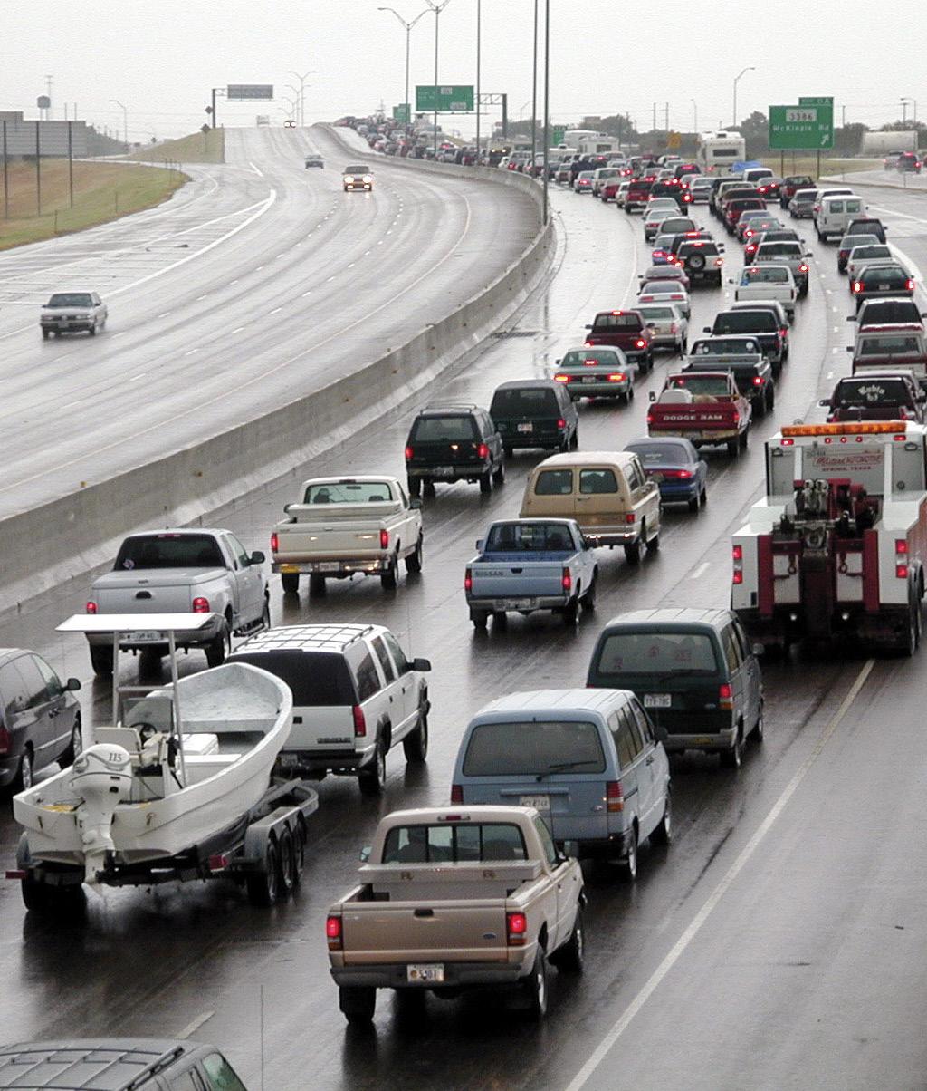
MANDATORY This is the final and mostserious phase ofevacuation. Authorities will put maximum emphasis on encouraging evacuation and limiting entry into the risk area. Designated State Evacuation Routes will be enhanced, thereby instituting contraflow onmajor interstates and highways.
STATE EMERGENCY ALERT SYSTEM (EAS) A ll residents should monitor their local EAS station for authoritative evacuation and shelter information. Evacuation route signs (shown below) are located on all parish and state roads that have been designated as major evacuation routes. The smaller sign indicates the (EAS) radio station to monitor for the particular area of the state through which you are traveling. The EAS radio station will broadcast the latest weather reports, road conditions and shelter location. In addition, information (date, time and locations) will be announced. As the storm gets closer to the risk area, information will be issued every two hours. State Emergency Broadcasting System information is broadcast on the following stations:
RADIO WWL 870 AM KBZE 105.9 FM WLMG101.9 FM WEB tpcg.org houmatimes.com houmatoday.com TELEVISION WAFB CH 9 Baton Rouge WBRZ CH 2 Baton Rouge WWL CH 4 New Orleans WVUE CH 8 New Orleans WDSU CH 6 New Orleans WGNOCH 26 New Orleans HTV CH 10 Houma

HURRICANE EVACUATION GUIDELINES
Prepare to evacuate if advised to do so by the governor or elected officials through radio or television announcements. Plan to evacuate as early as possible before hurricane gale-force winds and storm surges force road closings. Leaving early may also help you to avoid massive traffic jams encountered during late evacuationefforts. Listento the radio and/or television for evacuation and sheltering information.
STORM ADVISORIES ARE ISSUED AS FOLLOWS:
TROPICAL STORM WATCH Tropical storm conditions are possible inthe specified area ofthe watch, usually within 48 hours. TROPICAL STORM WARNING Tropical storm conditions are expected inthe specified area ofthe warning, usually within 36 hours. HURRICANE WATCH Hurricane conditions are expected in the specified area ofthe watch, usually within 48 hours. HURRICANE WARNING Hurricane conditions are expected inthe specified area ofthe warning, usually within 36 hours.
It is important to know which hurricane evacuation zone you reside in. Terrebonne Parish residents can enter their address on the following webpage to determine which hurricane evacuation zone they reside in: www.tohsep.com/evacuation.

HURRICANE EVACUATION TIPS
LIVING IN A SHELTER Residents should develop a “game plan” in order to assist them and their families to be prepared for any disaster. Assistance on developing a game plan can be found online at WWW.GETAGAMEPLAN.ORG. Residents should have enough supplies to last each family member at least 72 hours (3 days). Whenstate and local officials issue an evacuation order, residents should heed those orders to protect themselves and their families. Residents should be aware that when an evacuation order is issued, there may not be any emergency services such as fire, police, EMS or even hospital services to assist them during hurricanes.
Families and individuals need to be aware that the “FIRST 72 HOURS ARE ON YOU.” You should have food, water and necessary supplies to last you and each member of your family for 72 hours. Relief supplies may not be available to the parish before 72 hours.
People gathered in public and private shelters to escape hurricanes and other disasters might have to stay there—at least part of the time— for up to two weeks. RE-ENTRY INFO The parish reentry program enables the parish to safely allow businesses the minimum number of employees needed to do an assessment of their facility following an emergency evacuation. Those assessors will be able to make necessary arrangements
if any are needed to bring the business back online once it is deemed safe to do so. If you have any questions about the parish reentry program contact us at (985) 873-6357, or email oep@ tpcg.org. If your company wishes to participate in the pre-screening process, please submit an application online at http://www.parishreentry. com. You will be notified once your application is approved. TO AUGMENT THE SUPPLIES OF WATER AND FOOD WHERE SHELTERS ARE USUALLY LOCATED, YOU SHOULD PLAN TO TAKE THE FOLLOWING WITH YOU: • As much drinkable liquids (water, fruit and vegetable juices, soft drinks, etc.) and ready-to-eat food as you can carry to the shelter. • Special medicines or foods required by members of your family, such as insulin, heart medicines and dietetic food. • A blanket for each family member. • Abattery-powered radio, flash light, extra batteries for each and writing materials for taking notes of information given over the radio. • Baby needs (formula, medicine, diapers and baby wipes). • Personal toiletries (toothpaste, toothbrush, soap or baby wipes, deodorant, shampoo, shaving cream and razor, feminine hygiene items). Return home when authorities tell you it is safe. DO NOTturn gas or electricity on at your home without contacting the utility company that supplies your residence. You should NEVER connect a generator directly to your house without a transfer switch. A transfer switch will prevent the back-feed of electricity back to the main utility lines.
IF YOU LIVE IN AN UNSAFE STRUCTURE, MANUFACTURED HOME OR RESIDENCE SUBJECT TO FLOODING, BE PREPARED TO EVACUATE WHEN RECOMMENDED BY STATE AND LOCAL OFFICIALS. • Before hurricane season, check with local emergency preparedness officials for evacuationplans in your area and obtain a copy. • Select your evacuation route as identified inthe planand your destination: Friends and relatives well outside the flood riskarea, Hotel or motel, Public shelters, Keep your car fueled • Carry along survival supplies: Family medication, First aid kit, Bottled water and canned or dried provisions, Infant provisions and games, etc., for children • Keep important papers with you in a waterproof container or zippertop bag at all times: Insurance policies, Household contents inventory, Mortgage papers • Shutoffwater, electricity and gas when told to do so.
NATIONAL HURRICANE CENTER TERMS TO KNOW
ADVISORY Official informationissued by tropical cyclone warning centers describing all tropical cyclone watches and warnings ineffect, along with details concerning tropical cyclone locations, intensity and movement, and precautions that should be taken. Advisories are also issued to describe: (a) tropical cyclones prior to issuance of watches and warnings and (b) subtropical cyclones. BEST TRACK A subjectively-smoothed representation of a tropical cyclone’s location and intensity over its lifetime. The best track contains the cyclone’s latitude, longitude, maximum sustained surface winds, and minimum sealevel pressure at six hourly intervals. Best track positions and intensities, which are based on a post-storm assessment of all available data, may differ from values contained instorm advisories. They also generally will notreflectthe erratic motionimplied by connecting individual center-fix positions. CENTER Generally speaking, the vertical axis ofa tropical cyclone, usually defined by the location of minimum wind or minimum pressure. The cyclone center position can vary with altitude. In advisory products, refers to the center position at the surface. CENTER / VORTEX FIX The location of the center of a tropical or subtropical cyclone obtained by reconnaissance aircraft penetration, satellite, radar or synoptic data. CENTRAL NORTH PACIFIC BASIN The region north of the equator between 140W and the international date line. The Central Pacific Hurricane Center (CPHC) inHonolulu, Hawaii, is responsible for tracking tropical cyclones in this region. CYCLONE An atmospheric closed circulation rotating counterclockwise in the NorthernHemisphere and clockwise inthe SouthernHemisphere. DIRECT HIT A close approach of a tropical cyclone to a particular location. For locations on the left-hand side of a tropical cyclone’s track (looking in the direction of motion), a direct hit occurs when the cyclone passes to within a distance equal to the cyclone’s radius of maximum wind. For locations on the right-hand side of the track, a direct hit occurs when the cyclone passes to within a distance equal to twice the radius of maximum wind. Compare indirect hit, strike. EASTERN NORTH PACIFIC BASIN The portionofthe North Pacific Ocean east of 140W. The National Hurricane Center inMiami, Fla., is responsible for tracking tropical cyclones in this region. EYE The roughly circular area of comparatively light winds that encompasses the center of a severe tropical cyclone. The eye is either completely or partially surrounded by the eyewall cloud. EYEWALL / WALL CLOUD An organized band or ring of cumulonimbus clouds that surround the eye, or light-wind center of a tropical cyclone. Eyewall and wall cloud are used synonymously. EXTRATROPICAL A term used in advisories and tropical summaries to indicate that a cyclone has lost its “tropical” characteristics. The term implies both poleward displacement of the cyclone and the conversion of the cyclone’s primary energy source from the release of latent heat of condensation to baroclinic (the temperature contrast between warm and cold air masses) processes. It is important to note that cyclones can become extratropical and still retain winds of hurricane or tropical storm force. EXTRATROPICAL CYCLONE A cyclone of any intensity for which the primary energy source is baroclinic, resulting from the temperature contrast between warm and cold air masses. FUJIWHARA EFFECT The tendency of two nearby tropical cyclones to rotate cyclonically about each other. GALE WARNING A warning of 1-minute sustained surface winds in the range of 34 kt (39 mph or 63 km/hr) to 47 kt (54 mph or 87 km/hr), either predicted or occurring and not directly associated with tropical cyclones.
HIGH WIND WARNING Ahigh wind warning is defined as 1-minute average surface winds of 35 kt (40 mph or 64 km/hr) or greater lasting for 1 hour or longer, or winds gusting to 50 kt (58 mph or 93 km/ hr) or greater regardless of duration that are either expected or observed over land. HURRICANE / TYPHOON A tropical cyclone in which the maximum sustained surface wind (using the U.S. 1-minute average) is 64 kt (74 mph or 119 km/hr) or more. The term hurricane is used for NorthernHemisphere tropical cyclones east of the international date line to the Greenwich Meridian. The term typhoonis used for Pacific tropical cyclones north of the equator west of the international date line. HURRICANE LOCAL STATEMENT A public release prepared by local National Weather Service offices inor near a threatened area giving specific details for its county/parish warning area on (1) weather conditions, (2) evacuation decisions made by local officials, and (3) other precautions necessary to protect life and property. HURRICANE SEASON The portion of the year having a relatively high incidence of hurricanes. The hurricane season in the Atlantic, Caribbean and Gulf of Mexico runs from June 1 to Nov. 30. The hurricane seasoninthe EasternPacific basin runs from May 15 to Nov. 30. The hurricane season in the Central Pacific Basinruns from June 1 to Nov. 30. HURRICANE WARNING An announcement that hurricane conditions (sustained winds of 74 mph or higher) are expected somewhere withinthe specified area. Because hurricane preparedness activities become difficultonce winds reach tropical storm force, the hurricane warning is issued 36 hours in

advance of the anticipated onset of tropical-storm-force winds. HURRICANE WATCH An announcement that hurricane conditions (sustained winds of 74 mph or higher) are possible within the specified area. Because hurricane preparedness activities become difficult once winds reach tropical storm force, the hurricane watch is issued 48 hours in advance of the anticipated onset of tropical-storm-force winds. INDIRECT HIT Generally refers to locations that do not experience a direct hit from a tropical cyclone, but do experience hurricane-force winds (either sustained or gusts) or tides of at least 4 feet above normal. INVEST A weather system for which a tropical cyclone forecastcenter (NHC, CPHC or JTWC) is interested in collecting specialized data sets (e.g., microwave imagery) and/or running model guidance. Once a system has been designated as an invest, data collection and processing is initiated on a number of government and academic websites, including the Naval Research Laboratory (NRL) and the University of Wisconsin Cooperative Institute for Meteorological Satellite Studies (UW-CIMSS). The designation of a system as an invest does
not correspond to any particular likelihood of development of the system into a tropical cyclone; operational products such as the Tropical Weather Outlook or the JTWC/TCFA should be consulted for this purpose. LANDFALL The intersection of the surface center of a tropical cyclone with a coastline. Because the strongest winds in a tropical cyclone are not located precisely at the center, it is possible for a cyclone’s strongest winds to be experienced over land even if landfall does not occur. Similarly, it is possible for a tropical cyclone to make landfall and have its strongest winds remain over the water. Compare direct hit, indirect hit and strike. MAJOR HURRICANE Ahurricane thatis classified as Category 3 or higher. NATIONAL GEODETIC VERTICAL DATUM OF 1929 [NGVD 1929] Afixed reference adopted as a standard geodetic datum for elevations determined by leveling. The datum was derived for surveys from a general adjustmentofthe first-order leveling nets of both the United States and Canada. In the adjustment, mean sea level was held fixed as observed at 21 tide stations in the United States and 5 in Canada. The year indicates the time of the general adjustment. A synonym for Sea Level Datum of 1929, the geodetic datum is fixed and does not take into account the changing stands of sea level. Because there are many variables affecting sea level, and because the geodetic datum represents a bestfitover a broad area, the relationship between the geodetic datum and local mean sea level is not consistent from one location to another in either time or space. For this reason, the National Geodetic Vertical Datum should not be confused with mean sea level.
POST-STORM REPORT Areportissued by a local National Weather Service office summarizing the impact of a tropical cyclone on its forecast area. These reports include information on observed winds, pressures, storm surges, rainfall, tornadoes, damage and casualties. POST-TROPICAL CYCLONE A former tropical cyclone. This generic term describes a cyclone thatno longer possesses sufficienttropical characteristics to be considered a tropical cyclone. Posttropical cyclones can continue carrying heavy rains and high winds. Note that former tropical cyclones that have become fully extratropical … as well as remnant lows … are two classes of post-tropical cyclones. PRELIMINARY REPORT Now known as the “Tropical Cyclone Report.” A report summarizing the life history and effects ofanAtlantic or EasternPacific tropical cyclone. Itcontains a summary of the cyclone life cycle and pertinent meteorological data, including the post-analysis best track (six hourly positions and intensities) and other meteorological statistics. It also contains a description of damage and casualties the system produced, as well as information on forecasts and warnings associated with the cyclone. NHC writes a report on every tropical cyclone in its area of responsibility. PRESENT MOVEMENT The best estimate of the movement of the center of a tropical cyclone at a given time and given position. This estimate does notreflectthe short-period, small-scale oscillations of the cyclone center. RADIUS OF MAXIMUM WINDS The distance from the center of a tropical cyclone to the location of the cyclone’s maximum winds. In well-developed hurricanes, the radius of maximum winds is generally found at the inner edge of the eyewall. RAPID INTENSIFICATION An increase in the maximum sustained winds of a tropical cyclone of at least 30 kt in a 24-hour period. RELOCATED A term used in an advisory to indicate that a vector drawn from the preceding advisory position to the latest known position is not necessarily a reasonable representation of the cyclone’s movement. REMNANT LOW A post-tropical cyclone that no longer possesses the convective organization required of a tropical cyclone and has maximum sustained winds of less than 34 knots. The term is most commonly applied to the nearly deep-convection-free swirls of stratocumulus in the Eastern North
Pacific. SAFFIR-SIMPSON HURRICANE WIND SCALE The Saffir-SimpsonHurricane Wind Scale is a 1 to 5 categorization based on the hurricane’s intensity at the indicated time. The scale provides examples of the type of damage and impacts in the United States associated with winds of the indicated intensity. The following table shows the scale broken down by winds:
CATEGORY WIND SPEED (MPH) DAMAGE
1
2
3
4
5
74-95
96-110
111-129
130-156
>156 Very dangerous winds will produce some damage Extremely dangerous winds will cause extensive damage Devastating damage will occur Catastrophic damage will occur Catastrophic damage will occur
A detailed description of the Saffir-Simpson Hurricane Wind Scale is available at http://www.nhc.noaa.gov/aboutsshws.php. STORM SURGE An abnormal rise in sea level accompanying a hurricane or other intense storm, and whose heightis the difference between the observed level of the sea surface and the level that would have occurred in the absence of the cyclone. Storm surge is usually estimated by subtracting the normal or astronomic high tide from the observed storm tide. STORM TIDE The actual level of sea water resulting from the astronomic tide combined with the storm surge. STORM WARNING A warning of 1-minute sustained surface winds of 48 kt (55 mph or 88 km/hr) or greater, either predicted or occurring, not directly associated with tropical cyclones.

Strike Circle
Radius 62.5 nm
50 nm 75 nm Hurricane Path
STRIKE For any particular location, a hurricane strike occurs if that location passes within the hurricane’s strike circle, a circle of 125 n mi diameter, centered 12.5 n mi to the right of the hurricane center (looking in the direction of motion). This circle is meant to depict the typical extent of hurricane-force winds, which are approximately 75 n mi to the right of the center and 50 n mi to the left. SUBTROPICAL CYCLONE A non-frontal low pressure system that has characteristics of both tropical and extratropical cyclones. This system is typically an upper-level cold low with circulation extending to the surface layer and maximum sustained winds generally occurring at a radius of about 100 miles or more from the center. In comparison to tropical cyclones, such systems have a relatively broad zone of maximum winds that is located farther from the center, and typically have a less symmetric wind field and distributionofconvection. SUBTROPICAL DEPRESSION A subtropical cyclone in which the maximum sustained surface wind speed (using the U.S. 1-minute average) is 33 kt (38 mph or 62 km/hr) or less. SUBTROPICAL STORM A subtropical cyclone in which the maximum sustained surface wind speed (using the U.S. 1-minute average) is 34 kt (39 mph or 63 km/hr) or more. SYNOPTIC TRACK Weather reconnaissance missionflownto provide vital meteorological information in data sparse ocean areas as a supplement to existing surface, radar and satellite data. Synoptic flights better define the upper atmosphere and aid in the prediction of tropical cyclone development and movement.
TROPICAL CYCLONE A warm-core non-frontal synoptic-scale cyclone, originating over tropical or subtropical waters, with organized deep convection and a closed surface wind circulation abouta well-defined center. Once formed, a tropical cyclone is maintained by the extraction of heat energy from the ocean at high temperature and heat export at the low temperatures ofthe upper troposphere. Inthis, they differ from extratropical cyclones, which derive their energy from horizontal temperature contrasts in the atmosphere (baroclinic effects). TROPICAL CYCLONE PLAN OF THE DAY A coordinated mission plan that tasks operational weather reconnaissance requirements during the next 1100 to 1100 UTC day or as required, describes reconnaissance flights committed to satisfy both operational and research requirements, and identifies possible reconnaissance requirements for the succeeding 24-hour period. TROPICAL DEPRESSION A tropical cyclone in which the maximum sustained surface wind speed (using the U.S. 1-minute average) is 33 kt (38 mph or 62 km/hr) or less. TROPICAL DISTURBANCE A discrete tropical weather system of apparently organized convection-generally 100 to 300 n mi in diameteroriginating in the tropics or subtropics, having a nonfrontal migratory character, and maintaining its identity for 24 hours or more. It may or may not be associated with a detectable perturbationofthe wind field. TROPICAL STORM A tropical cyclone in which the maximum sustained surface wind speed (using the U.S. 1-minute average) ranges from 34 kt (39 mph or 63 km/hr) to 63 kt (73 mph or 118 km/hr). TROPICAL STORM WARNING An announcement that tropical storm conditions (sustained winds of 39 to 73 mph) are expected somewhere withinthe specified area within36 hours. TROPICAL STORM WATCH An announcement that tropical storm conditions (sustained winds of 39 to 73 mph) are possible within the specified area within48 hours. TROPICAL WAVE A trough or cyclonic curvature maximum in the tradewind easterlies. The wave may reach maximum amplitude in the lower middle troposphere.
HURRICANE WARNING PREPARATIONS
WHEN YOUR AREA RECEIVES A HURRICANE WARNING:
1. Keep your radio, television or NOAA weather radio on and listen for the lastest Weather Service advisories, as well as special instructions from your local government. Also listen for tornado watches and warnings. Tornadoes spawned by a hurricane are among the storm’s worst killers. 2. Plan your time before the storm arrives and avoid the last-minute hurry that might leave you marooned or unprepared. 3. Leave low-lying areas that might be swept by high tides, storm waves or storm surge. 4. Leave manufactured homes for more substantial shelter. Unless properly anchored, manufactured homes are particularly vulnerable to overturning during strong winds. 5. Moor your boat securely before the storm arrives or move it to a designated safe area. When your boat is moored, leave it and don’t return until the storm has passed your area.

6. Board up windows or protect them with storm shutters or tape. Danger to small windows is mainly from wind-driven debris. Large windows may be broken by wind pressure. 7. Secure outdoor objects that might be blown away. Garbage cans, garden tools, toys, signs, porch furniture and a number of other harmless items become missiles of destruction in hurricane winds. Anchor them or store them inside before the storm strikes. 8. Store drinking water in clean bathtubs, jugs, bottles and cooking utensils. The parish’s water system may be contaminated or damaged by the storm. Stay

tuned to area newscast, to see if you may need to boil water before use. 9. Check your battery-powered equipment. Your radio may be your only link with the world outside of the hurricane. Emergency cooking facilities and flashlights will be essential if utility services are interrupted. 10. Keep your car fueled. Service stations may be inoperable for several days after the storm strikes because of floodingorinterrupted electricalpower. 11. Stay at home if it is sturdy and on high ground. If not–and especially if local authorities order an evacuation of your area–move to a designated shelter and stay there until the storm is over. 12. Remain indoors during the hurricane. Travel is extremely dangerous when winds and tides are whipping through your area. Don’t be fooled by the “eye” of the hurricane. If the storm center passes directly overhead, there will be a lull in the wind lasting from a few minutes to half an hour or more. Stay in a safe place unless emergency repairs are absolutely necessary. Remember that at the other side of the “eye” the winds will increase rapidly to hurricane force and will come from the opposite direction.
STORM SURGE HURRICANES’ BIG KILLER
BOATS
Hurricanes are usually described in terms of their wind speeds, butflooding caused by high water and storm surge kills many more people than wind. Flooding is also responsible for much of the damage, especially within a few hundred yards of the shoreline. Boats ripped from their moorings, utility poles, parts of destroyed buildings and other debris crashing in the waves atop hurricane surge often destroy buildings that stood up to the wind.
Even without the weight of debris, water is a powerfully destructive force. A cubic foot of sea water weighs 64 pounds.
Water does more than batter; it scours away the sand ofbeaches and dunes. High water and pounding waves carry away the sand under the sea walls, buildings and roads. As the water begins rising in advance of the storm–sometimes hours in advance–it erodes the beach and then the dunes or undercuts buildings behind the beach.
Storm surge isn’t a killer only along beaches facing the ocean; water is also pushed into bays and rivers. As the surge of water squeezes up a narrowing bay or river, it rises even higher.

HOW TO PREPARE YOUR BOAT FOR A HURRICANE: The Boat Owners Association of the United States has produced a free “Hurricane Warning Guide” to help owners properly secure their boats before a storm hits.
TO RECEIVE A FREE COPY OF THE GUIDE, WRITE: BOAT/U.S. Dept. G, 880 S. Pickett St. Alexandria, Va. 22304 OR VISIT WWW.BOATUS.COM/HURRICANES
HERE ARE SOME TIPS FROM THE GUIDE: 1. Storage ashore is a must for small outboards, trailer boats and performance boats with low freeboard. Sailboats–even some up to 30 feet in length–can be hauled out of the water and laid on their side. 2. Ifyou planto leave your boatafloat, the bestplace to take it during a hurricane is a small protected body of water called a “hurricane hole.” Ask the Louisiana Marine Patrol, Coast Guard or harbormaster about the availability of hurricane holes in your area. 3. Be sure you have adequate anchors, fenders and extra long lines to secure your boat for a storm. At a dock, make all lines as long as possible and add a second set of oversized lines. 4. Attach chafing gear to each mooring line. Lines tend to break when they rub against the boat or dock. Old canvas or garden hoses can be used by tying and taping it in place around the line. 5. Use duct tape to seal around the hatches, ports, windows, doors and vents. 6. Take home all electronics and valuable equipment. Electronics can be damaged by high water and they’re the firstthings takenifvandals come aboard after a storm. 7. Remove all boat documents and take them home for safekeeping. Remember to put them back on the boat after the storm. 8. Last, but not least, GO HOME. No one should stay aboard a boat during a hurricane. When winds are blowing 100 miles per hour or more, tides are surging and visibility is limited to two or three feet, there is little you can do to save a boat in trouble.
Do not stay in manufactured homes during a hurricane. Even if a manufactured home is anchored, there is no guarantee it will withstand the strong winds of a hurricane. If you are unable to evacuate before the hurricane hits, stay inside. Do not be fooled by the eye of the hurricane and its temporary period of peaceful weather conditions. The length of time within the eye varies from several minutes to a couple of hours, depending on the size of the storm. The larger and more intense the hurricane, the larger the eye. Stay away from windows and glass doors. You could be struckby flying debris. Continue to listento your radio or television for hurricane updates and emergency information. DURING THE HURRICANE WHEN YOU GET HOME L ook for visible structure damage before you go inside. Watch for loose or dangling electrical power lines and broken sewer or water mains. DO NOTconnect portable generators directly to your electrical panel to prevent electrical back-feed to the main utility lines.
AFTER THE HURRICANE
1. Remain in shelter until informed by local authorities that it is safe to leave. 2. Keep tuned to your local radio or television station or the Terrebonne Parish Consolidated Government website at WWW.TPCG.ORG for advice and instructions from your local government on: • Where to go to obtain necessary medical care in your area. • Where to go for necessary emergency assistance for housing, clothing and food. • Ways to help yourself and your community recover from the emergency. 3. Stay out of disaster areas. Sightseeing interferes with essential rescue and recovery work and may be dangerous as well. 4. Drive carefully along debris-filled streets. Roads may be undermined and may collapse under the weight of an automobile. 5. Avoid loose or dangling wires and report them immediately to your power company, the Terrebonne Parish Office ofHomeland Security and Emergency Preparedness at (985) 873-6357, or the local police or fire department. 6. Reportbrokensewer or water mains to the Terrebonne Parish Office of Homeland Security and Emergency Preparedness at(985) 873-6357. 7. Preventfires. Lowered water pressure may make fire fighting difficult. 8. Checkrefrigerated food for spoilage ifpower has beenoffduring the storm. TIP:Before evacuating, place all freezer and refrigerator items in plastic bags and place back into freezer or refrigerator. If the food spoils, just throw away the plastic bags. 9. Businesses seeking reentry should register at: http://www.parishreentry.com prior to the hurricane.

REMEMBER Hurricanes moving inland can cause severe flooding. Stay away from river banks and streams until all potential flooding has passed. Local authorities will announce when it is safe to return to your home. Stay tuned to local radio or television stations or the Terrebonne Parish Consolidated Government website (WWW.TPCG. ORG) for current information.


