
6 minute read
Footloose in the Foothills


FOOTLOOSE IN THE FOOTHILLS El Dorado

Advertisement
El Dorado Trail A SCENIC ROUTE FOR BIKERS, HIKERS AND EQUESTRIANS

by JOLAINE COLLINS photography by JOLAINE COLLINS, JACKIE NEAU and JEFF BARKER
Hiking, biking and horseback riding through El Dorado County are some of the most enjoyable ways to appreciate the natural beauty and historic past of the Sierra Nevada Foothills. The El Dorado Trail provides opportunities to do all those things, and more.
Winding through 37 miles of Gold Rush landscapes, the El Dorado Trail meanders west from the Apple Hill community of Camino to the El Dorado County line just south of Folsom, hugging the Pony Express Trail and logging routes along the way.
While much of the trail climbs through pine forests and majestic oaks or stretches along farms, range land and creeks, some of it connects to small business districts. Adjacent roads beckon users to pause at restaurants, wineries and shops housed in historic buildings. Ample parking near several trailheads, and paved routes with ADA accessibility, make this an attractive trail for short jaunts or longer adventures.
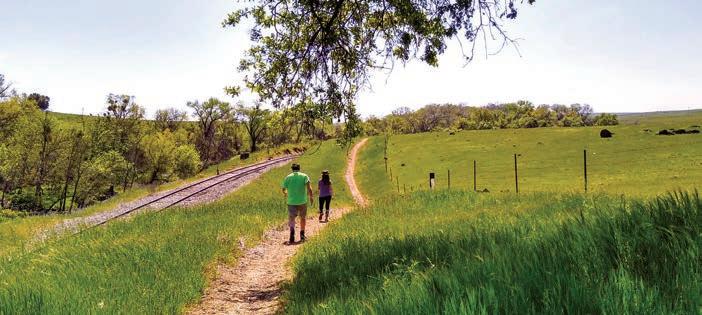
e El Dorado Trail—which repurposes abandoned railroad beds—includes more than 12 continuous miles of paved surfaces for road bikes and pedestrians between the towns of El Dorado and Camino, and 25 miles of dirt trails suitable for mountain bikes, horseback riding and hiking.
Part of the nation’s growing 24,000-mile Rails-to-Trails Conservancy system, the trail follows two former rail lines, the Southern Pacific Railroad and Michigan-California Railroad. Its path includes Placerville’s Main Street, which was a stop along the Pony Express route. e rail-trail is a work in progress, with future extensions sketched from El Dorado Hills to South Lake Tahoe, along the Pony Express Trail. Regional planners envision eventually linking it to a system of interconnected trails and parks across Placer, Sacramento, Sutter, Yolo and Yuba counties.
“It’s the backbone of a future trail system that will connect many towns in El Dorado County,” says Jackie Neau, Placerville city councilmember and a longtime trail user and advocate. “It’s unique that it connects the region’s rural scene to the towns of Camino, Placerville and El Dorado.” Another striking aspect about the trail is that it’s very family friendly, she says. “You’ll see seniors getting in their morning exercise, kids learning how to ride their bikes, and moms walking babies in strollers. People of all ages enjoy the trail.”
VIEWS OF NATURE, HISTORY
For the past 30 years, Neau has biked and hiked the trail, taking in the beauty of flora and fauna during many changing seasons—enjoying vibrant fall colors, spring wildflowers and birds foraging in wetlands, cows grazing in lush meadows along creeks—all within a couple of miles of small industrial areas, schools, churches and residential neighborhoods. “It’s so serene,” she says.
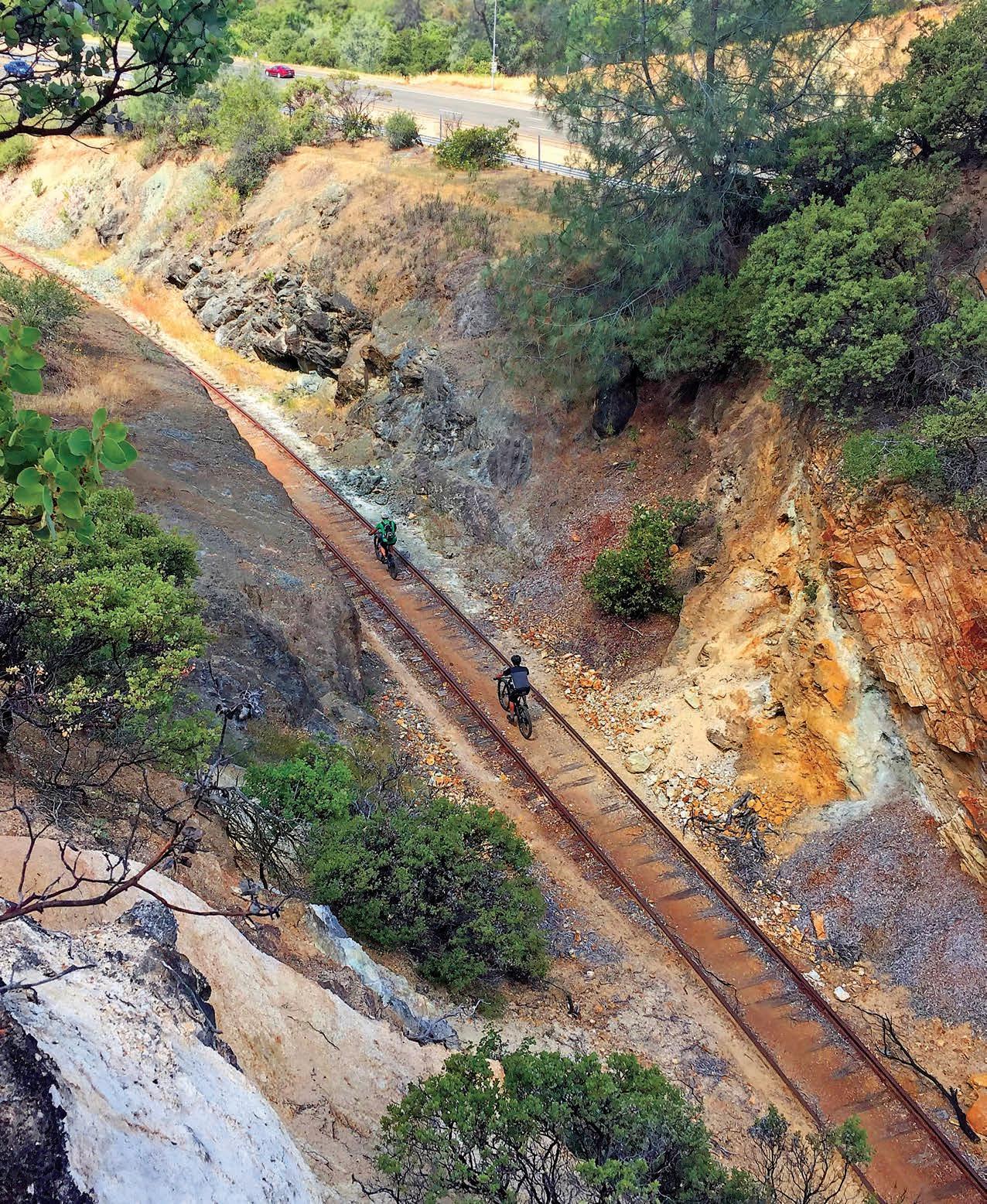
An area along the trail known as “ e Cut” reveals massive boulders that were divided many years ago to make room for the railroad track that connected the Sierra Nevada to the growing pioneer communities of Placerville, Folsom and Sacramento.
“It’s a fun adventure exploring these trails, their local history and rural surroundings,” says Neau. e trail does a great job of blending uses for bikers, hikers and equestrians. e newest part of the trail, a section that runs between Missouri Flat Road and Oriental Street in the town of El Dorado, features a Class One paved trail that winds through rolling terrain, and a dirt trail that runs parallel to portions of it. ey both allow biking, hiking and horseback riding.

The El Dorado Trail—which repurposes abandoned railroad beds—includes more than 12 continuous miles of paved surfaces for road bikes and pedestrians between the towns of El Dorado and Camino, and 25 miles of dirt trails suitable for mountain bikes, horseback riding and hiking.
Whether you’re seeking the serenity of a nature walk, a recreational ride on the saddle of a bike or a horse, or the adventure of rock hopping chunky terrain, the El Dorado Trail o ers a great route to do it all.
A RAILROAD FOUNDATION
Portions of the trail are simply railroad track with gravel-fi lled spaces between the ties. e corridor features a short section of track currently used by the El Dorado Western Railroad to run excursion train rides between Shingle Springs and El Dorado.
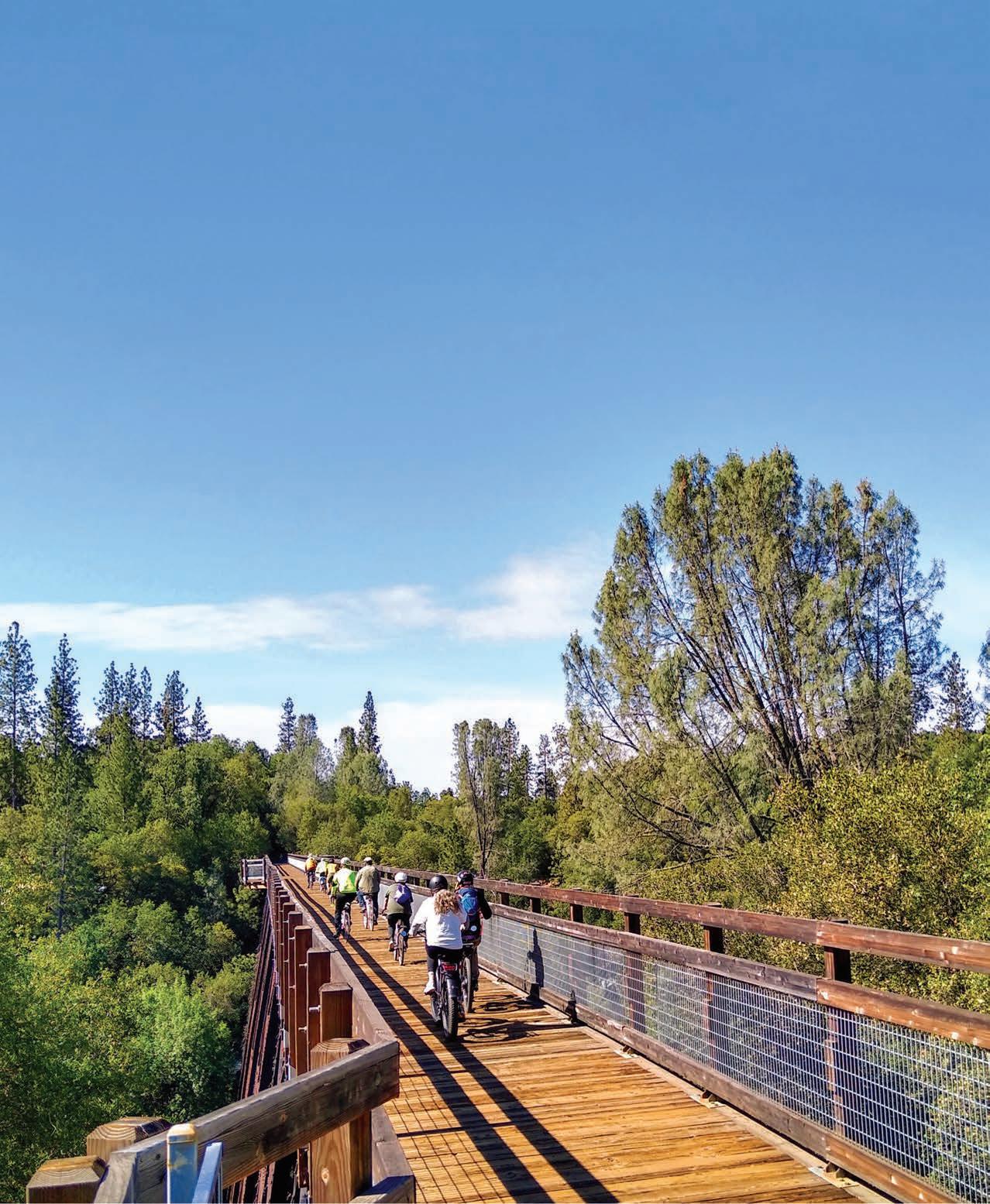
Another historic highlight is the century-old Weber Creek Bridge, a former railroad trestle refurbished as a scenic crossing for pedestrians and mountain bikers—many of whom have attached hundreds of “love locks” to the bridge’s lattice railing. e 100-foot-high bridge is less than a mile from the Missouri Flat Road trailhead in Placerville, not far from Historic Highway 49.
Along the trail, there are other remnants of the region’s railroad past, including discarded locomotive parts and rocky black cinders known as clinkers—the residue from burning coal.
PAVED TRAIL ADVENTURES

● EL DORADO COMMUNITY HALL TRAILHEAD: Begin at the far west end of the trail on Oriental Street, across from the El Dorado Post Offi ce on Pleasant Valley Road. Stay left to travel on the paved trail which passes through fi elds and gently rolling hills, with road crossings controlled by signals. You’re not far from Poor Red’s, a longtime landmark famous for its barbecue and Golden Cadillacs.
● SMITH FLAT JACQUIER ROAD TRAILHEAD: Look for the trail sign at the corner of Jacquier Road and Camelia Lane. You can venture uphill toward Camino or downhill toward Placerville from here. Consider bringing a cooler for storing fresh produce gathered from 24 Carrot Farm, located a few hundred yards up Jacquier Road. Hungry? Stop at Historic Smith Flat House, established in 1861, with its rock-walled cellar, pleasant outdoor courtyard and gazebo. e restaurant welcomes dogs and is open for dinner and lunch throughout the week.
● PLACERVILLE STATION TRAILHEAD: is leg of the trail travels along Placerville’s historic Main Street and off ers refueling stops at any of the town’s restaurants or shops. As you head up the hill, turn left on Bedford Avenue where the trail leaves Main Street and begins the climb to Camino. e next fi ve miles to the end of the paved trail near U.S. Highway 50 in Camino include a short railroad tunnel and a shady ascension through a mixed forest of cedars, ponderosa pines, oaks and madrones. Look for distant views of the Sacramento Valley.
Once you reach the end of the trail in Camino, residential streets will lead you to the hilltop tasting room of Chateau Davell Winery.
Whether you’re seeking the serenity of a nature walk, a recreational ride on the saddle of a bike or a horse, or the adventure of rock hopping chunky terrain, the El Dorado Trail off ers a great route to do it all.

Poor Red’s

Downtown Placerville 24 Carrot Farm


IF YOU GO
● You’ll fi nd a printable trail map with details about paved and dirt trails, parking, trailheads and restroom facilities at eldoradotrail.com.
● Respect all trail users. Bike riders use the right side of the trail and pedestrians walk on the left. Keep dogs on a leash with a tight lead.
● Binoculars are handy for spotting wildlife. Don’t forget to look down for the occasional rattlesnake.
● Bring water and snacks for scenic stops along the way.
● Extend your adventure at the restaurants, shops, wineries and breweries along the El Dorado Trail, including the one-mile stretch on Placerville’s Main Street.


