LANDSCAPE ARCHITECTURE

Sahar Rezaee
Master of Landscape Architecture
School of Architecture, Planning + Landscape
University of Calgary, Canada, AB
Master of Environmental Design
School of Environment
University of Tehran, Tehran, Iran

Sahar Rezaee
Master of Landscape Architecture
School of Architecture, Planning + Landscape
University of Calgary, Canada, AB
Master of Environmental Design
School of Environment
University of Tehran, Tehran, Iran
Ingelwood-Ramsay Urban Landscape Identity
Instructors: Professor Enrica Dall’Ara & Gordon Skilling
LAND 614 Landscape Architecture Studio II, Fall 2022
School of Architecture, Planning + Landscape
University of Calgary
Landscape of Movement
Instructors: Professor Twab Helmi
LAND 604 Landscape Architecture Studio I, Winter 2022
School of Architecture, Planning + Landscape
University of Calgary
Research-oriented Project Studio
Instructors: Professor Bev Sandalack / Jack Vanston
LAND 702 -Landscape Architecture Studio 3 Advanced-Winter 2023
School of Architecture, Planning + Landscape
University of Calgary
Innovative Planting Design Proposal
Instructors: Professor Mathis Natvic
LAND 602- Plants in the Landscape Fall 2022
School of Architecture, Planning + Landscape
University of Calgary
Thesis Research on Urban Ecological Network
Supervisor Professor Homa Irani Behbahani
Master of Environmental Design Thesis, Winter 2015
School of Environmental Design
University of Tehran, Iran

Ingelwood-Ramsay Urban Landscape Identity
Instructors: Professor Enrica Dall’Ara
LAND 614 Landscape Architecture Studio II, Fall 2022
wSchool of Architecture, Planning + Landscape University of Calgary
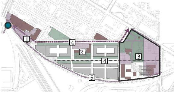
The work focuses on the redevelopment of Inglewood Brewery District. The vision is to give the public and the community the opportunityto reconnect with an old Calgary landmark, bringing it back to life, while also encouraging the further development of a walkable community.The idea is to integrate, develop and interlink the existing patterns that are formed by its previous industrial use, and to find a new interpretation with a new syntax.The landscape oriented transformation plan is set the framework to create an urban destination that is dynamic and engaging for generations to come through, to create a strong sense of identity. The Brewery Garden with its iconic and historical bronze statues, as a symbol of the Calgary Brewery Company,1930’s, mediates a system of new and refurbished connections between old picturesque garden, and new proposed site features.
PROJECT. 1
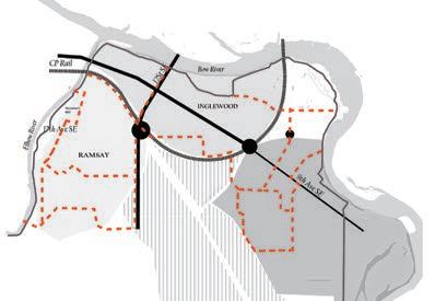
Inglewood – Ramsay District, Calgary, AB, Canada
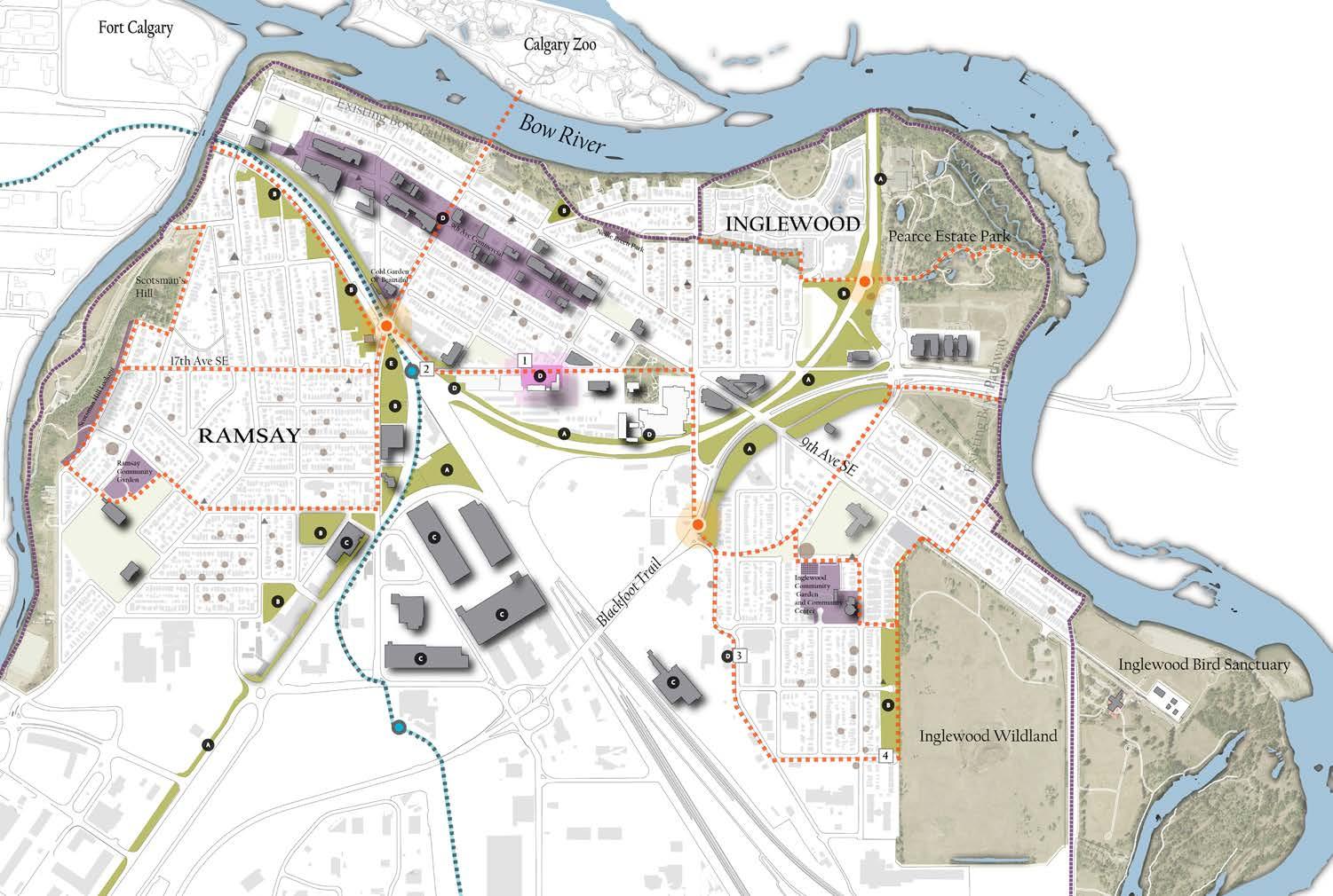
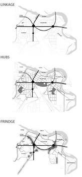
Address Fragmentation Caused by Rail and Vehicle Networks.
Increase Pedestrian/Bike Connectivity Between
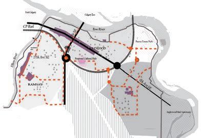
Preserve and Reveal Diversity of Local
Proposed central cultural hub to incorporate local cultural networks
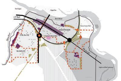
Creating an Integrated Community Green Infrastructure Network to Enhance Natural Spaces, Accebility, as well as Preserving Industrial Heritage.
In this project phase we conduct a comprehensive site analysis and leverage the findings to contribute to the master planning process to inform the project’s design decisions.
Collaborated with the talented team members (Breanna Thompson & Marcia P. Palmer) in conducting a comprehensive site analysis, actively contributing to data collection and assessment.
My role in master planning and diagramming,using design software AutoCAD and Illustrator to ensure that the master plan and associated diagrams were accurate, visually engaging, and effectively conveyed the intended ideas.
Data Sources: Calgary Open Data
•
•
•
•
•
“The design development for the revitalization of Inglewood’s historic brewery site focuses on preserving its rich heritage while transforming it into a vibrant mixed-use destination.”
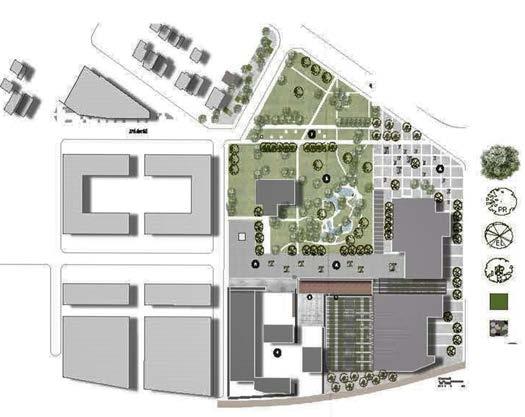
PROGRAMING AN INDUSTRIAL CENTRAL CULTURAL HUB
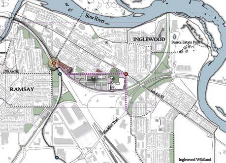

Industrial Heritage Precinct Courtyard Terellis Hops Garden
Heritage Barely Farm Sculpture Garden
3
Industrial Heritage Museum
9th Ave Entrance Plaza Mix-use commercial Brewery Brewery Heritage Garden
Brewery Museum Walkway
5 PRESERVE AND REVEAL DIVERSITY OF 5
By preserving the heritage opportunities, the project aims to celebrate the history of the brewery lands and create a sense of place that reflects the community’s identity, by activating Industrial heritage hub
Individual Project: Programming an Industrial Central Cultural Hub in Inglewood’s Historic Brewery Lands and design development for the revitalization of Inglewood’s historic brewery site to accommodate a range of cultural activities.
1 2 Proposed A B C D E E 20% 40% 10% 30%
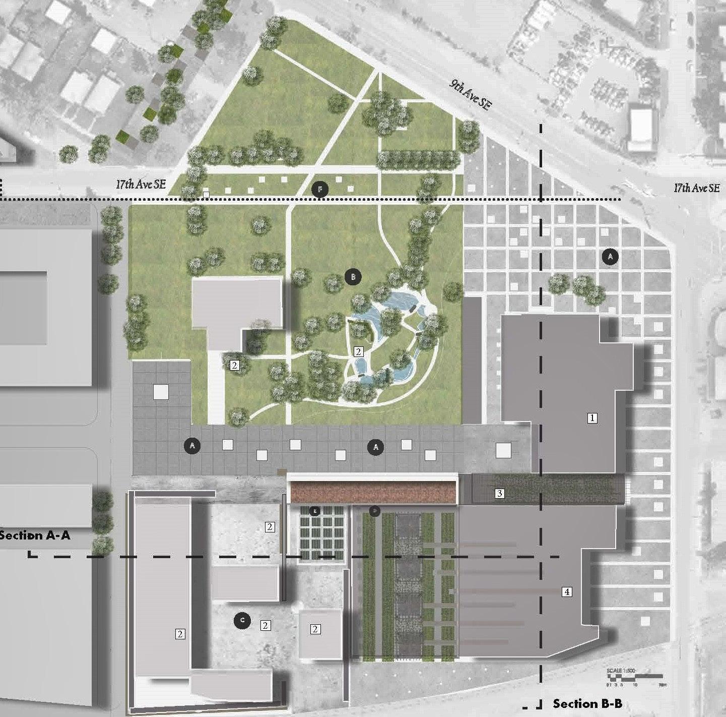
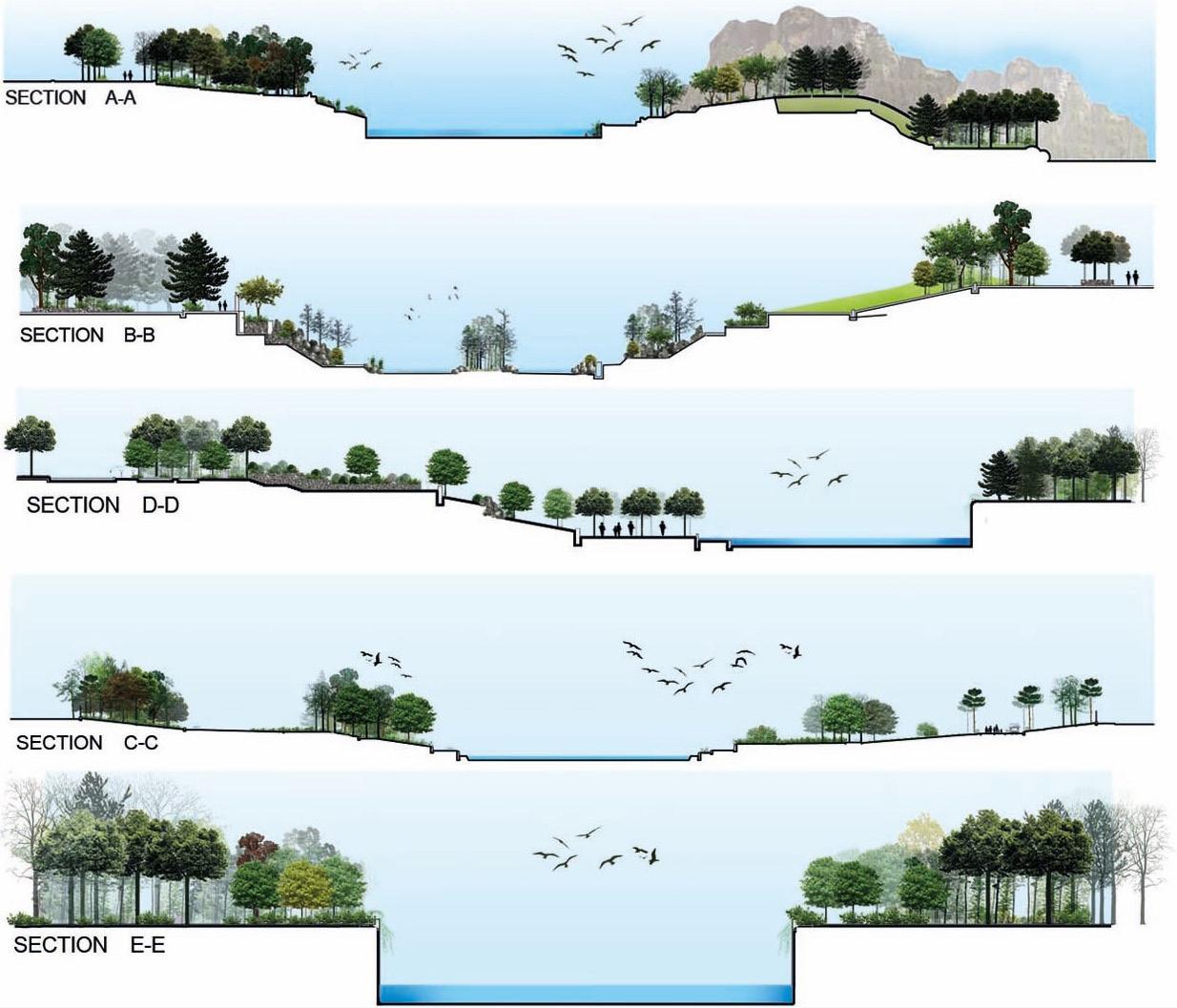
Section A-A
Section B-B
OPPORTUNITIES & CONSTRAINS
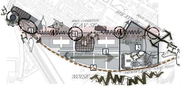
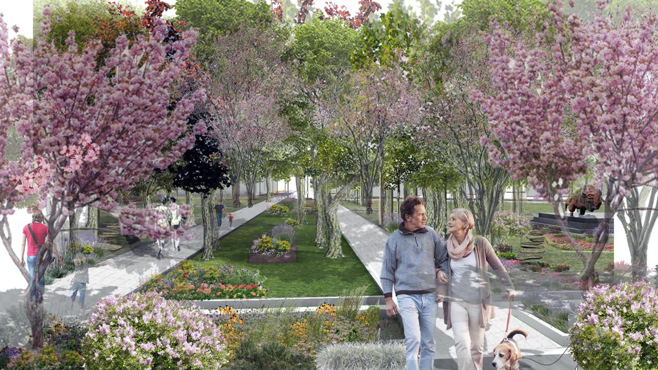
Inglewood Brewery Garden, Calgary, AB
Introducing DiverseTextures and Vibrant Colors
PreservingThe Existing Picturosque Trees
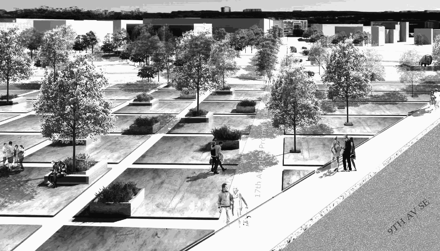
17th Avenue Promenade
Celebrating Art and Nature
TOOLS
Individual Project:
View 3
Preserving The Heritage Sculpture
View 2
View1
Seasonal Planting
Adding Texture and Color
Existing Picturosque Trees
Prunus Padus(Color&Texture)
Ulmus americana (Shadow)
Popolus alba (Texture)
Colorful Mix Pallet of Perennial and Grass
View 1
9AVE Enterance Plaza
View 2
Sculpture Garden Oasis
View 3
Brewery Couryrad Plaza
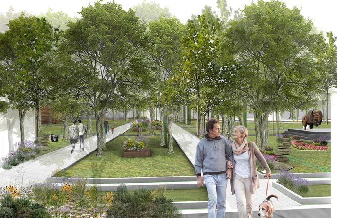
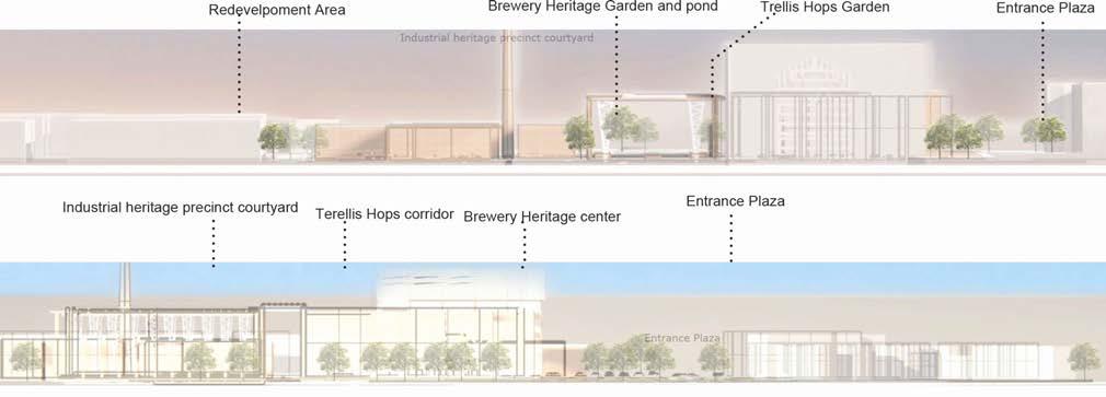
“ The design development focuses on creating seamless pathways within the brewery site, connecting 17th Ave & 9th Ave, while preserving the garden’s unique features.”
“Through the intervention, the old brewery backyard transformed into a captivating Heritage Garden, preserving the area’s history and creating a picturesque oasis.”
30% 50% 20%
Transforming the abondoned brewery building Terellis Hops Garden
Landscape of Movement
Instructors: Professor Twab Helmi
LAND 604 Landscape Architecture Studio I, Winter 2022
School of Architecture, Planning + Landscape University of Calgary
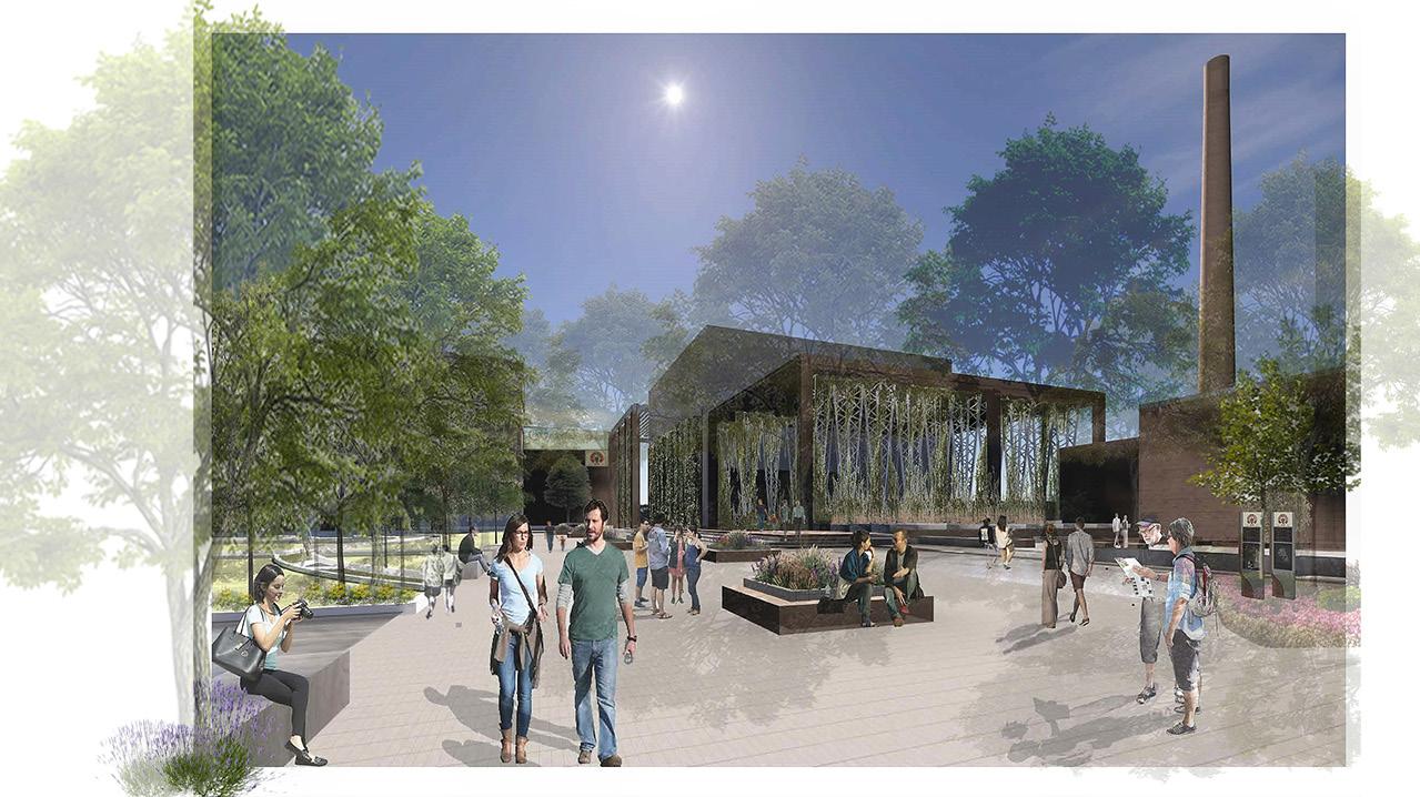
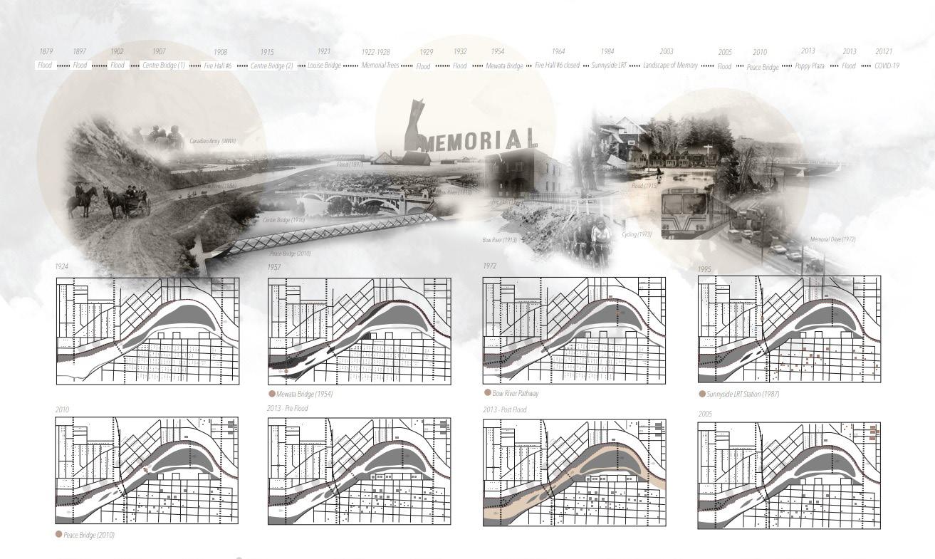
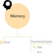
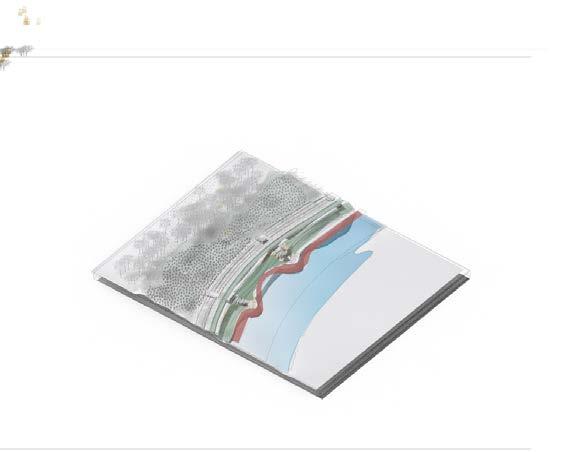
This project focuses on the revitalization of the Memorial Drive corridor along the Bow River, recognizing its unique urban landscape and the need for immediate attention. The goal is to assess the quality of space along the river and identify the top five locations that provide optimal access to the river’s edge. By analyzing the spatial layout, employing urban design elements, and considering the characteristics of observers, the project aims to create a transformative vision for underutilized spaces, turning them into a vibrant riverfront. This vision will offer the adjacent community a new range of potential activities to engage in, encompassing aspects of memory, infrastructure, environment, and recreation. The title encapsulates the objective of unlocking the area’s potential, transforming it into a thriving urban landscape that benefits both the space itself and the people who experience it.
PROJECT. 2
PROJECT OVERVIEW & SUMMARY
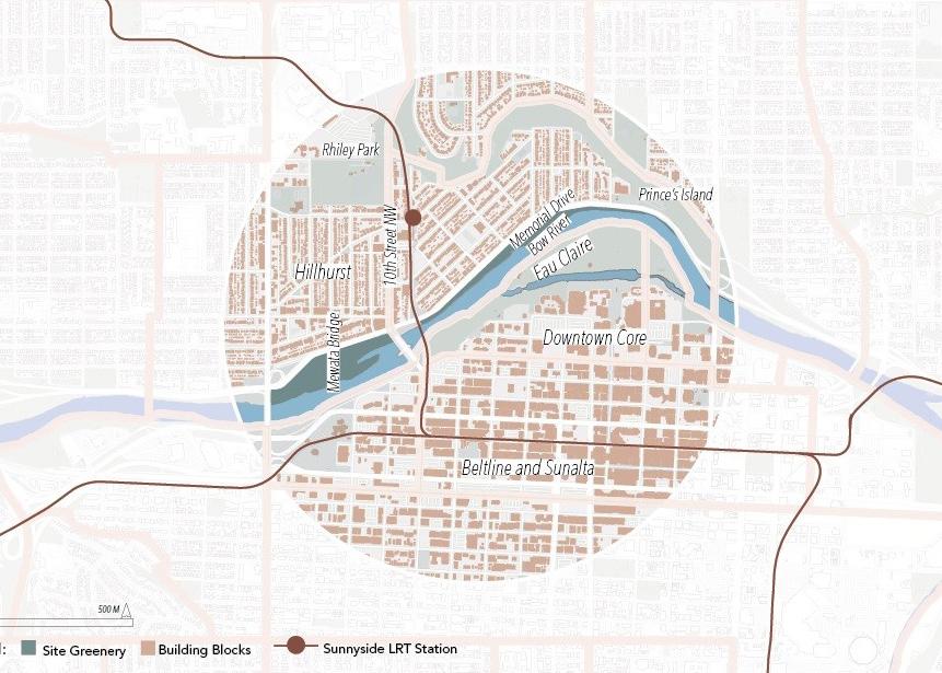

The project aimed to address flooding, pedestrian conflicts, and limited accessibility along the Memorial Drive corridor The goal was to identify effective strategies and design interventions to manage flood risks, enhance pedestrian safety, and ensure equitable access..
Collaborated with my friend Diba Mohebzadeh on inventory the spatial layout analysis and developed a comprehensive understanding of the riverfront, considering its history, infrastructure, environment, and recreational potential.
Individually, I evaluated and recommended the top five locations, identifying Optimal Locations for Enhanced Accessibility and Community Engagement.
TOOLS
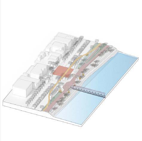
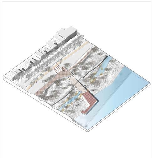
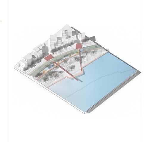

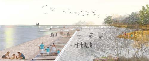
THAT DESIGNS PRINCIPLES: ACTIVATE, RECONNECT, CREATE AN ICONIC RIVERFRONT DESTINATION, IMPROVE VISITOR EXPERIENCE, AND INTERPRETIVE VALUE
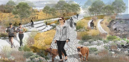
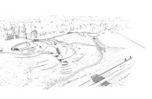
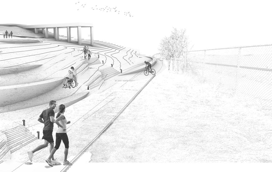
Moment 1: Iconic Soldier Memorial/ Lagacy’s Honor Moment 3: Sunny Beach Gateway/Nature’s Moment 5:Sunnyside Hiside Trail/ Multiuse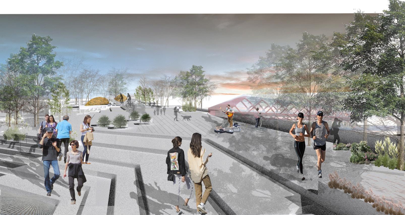
Transforming Flood Control Berms into Plaza Sitting Terraces for Gathering Spaces and
Enhancing Pathway Safety and Enjoyment: Separating Cycling and Pedestrian Routes Scenic Vewpoints
creating a flexible and accessible environment for all
DESIGN SCENARIOS
ENHANCING CONNECTIONS AND SERENITY
“The design intention behind expansion of repurposing flood control berms into plaza sitting terraces was to create an inviting platform for gathering, multi-use paths, and cycling spaces. This design aimed to address the issue of pedestrian conflict by providing a versatile and accessible environment., and fostering a sense of community.”
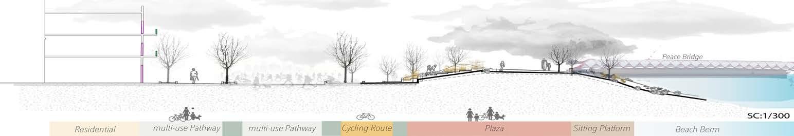
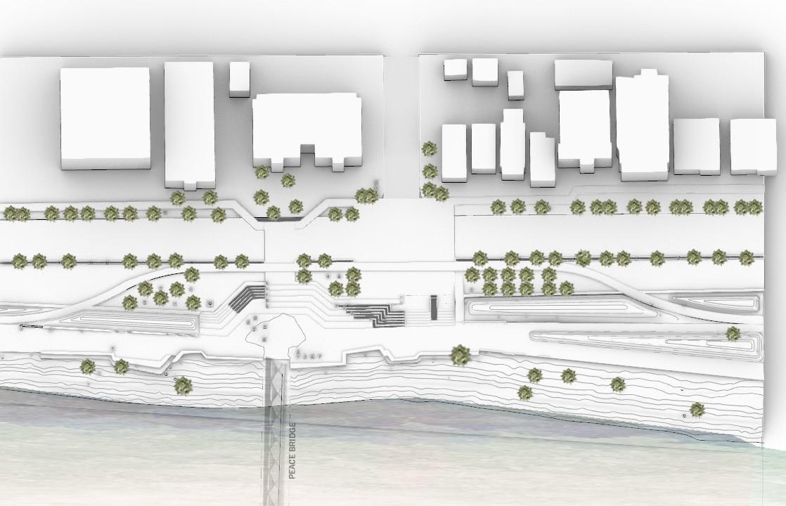
PEACE BRIDGE PLAZA SECTION PEACE BRIDGE PLAZAInstructors: Professor Bev Sandalack / Jack VanstoneLAND 702 -Landscape
Architecture Studio 3 - Advanced Winter 2023
School of Architecture, Planning + Landscape
University of Calgary
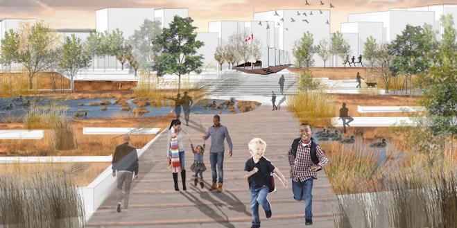
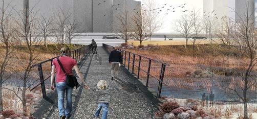
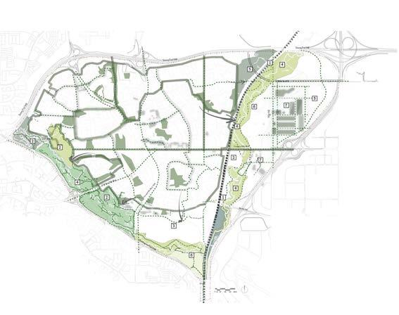
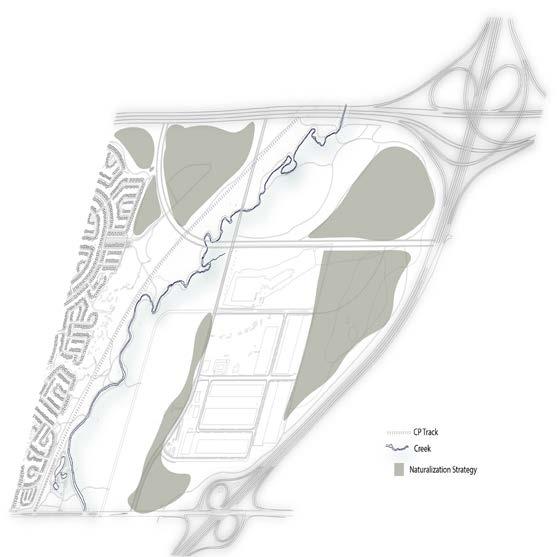
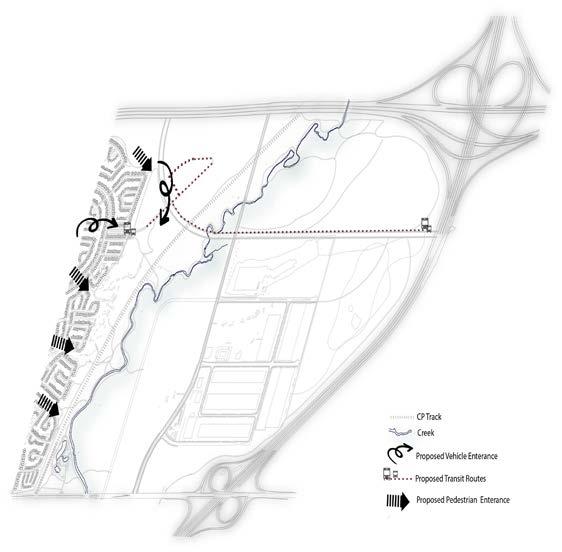
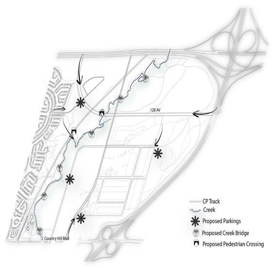
The Nose Creek lands in Calgary have been heavily impacted by urban development, agriculture, and industrial uses, leading to the fragmentation of natural areas. Despite being included in Calgary’s park master plan, the proposed connection of the riverfront and riparian areas as a park system has been neglected. To address these challenges, a holistic landscape architectural design approach is crucial, focusing on regional and neighborhood scales. Developing a comprehensive greenway network can integrate Nose Creek into Calgary’s park systems and ecological network, promoting connectivity, preserving natural lands, and providing citizens with equitable access to nature. This approach will enhance ecological resilience, improve community engagement, support climate resilience, and create a healthier and more sustainable city.


PROJECT. 3
PROJECT OVERVIEW & SUMMARY
Integrating Urban Structure to Green System
Greening Ecological Dead Zones (Industrial)
Connecting theTrail Systems
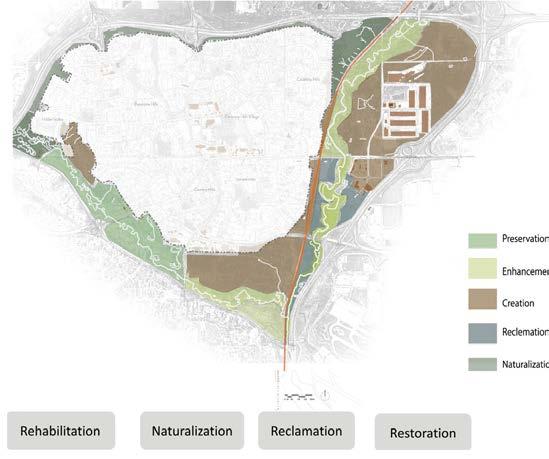
Setting intervention goals for the rehabilitation, renovation, and preservation of natural areas through strategically linked green spaces.
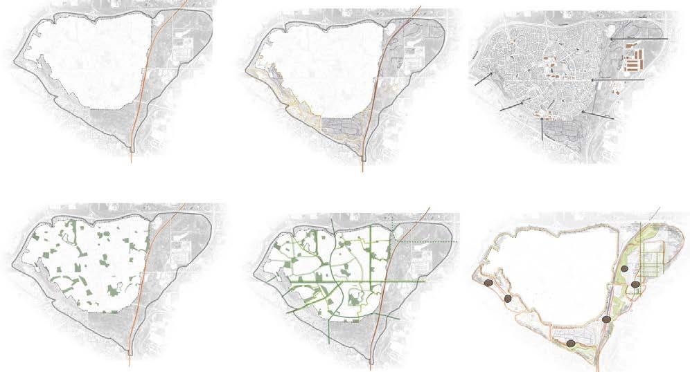
Planning an interconnected Park Network promotes community well-being and ecological balance preserving biodiversityproviding recreational opportunities.

Nose Creek Corridor is part of a network of prominent regional open space of city of Calgary.
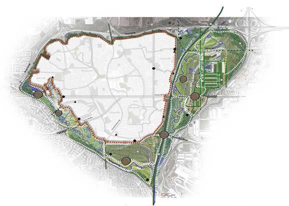
The masterplan envisions a comprehensive design approach that enhances the natural landscape while improving accessibility and prioritizing ecology and sustainability. A key component is the creation of greenway networks, connecting natural landforms, valleys, and urban roads. These networks serve as alternative regional green infrastructure, promoting environmental connectivity and enriching the overall ecological balance. The masterplan aims to achieve a harmonious relationship between nature and urban spaces, fostering accessibility, ecological preservation, and community well-being.
Vibrant Living Space
Nose Creek Eco Corridor, Calgary, AB
DESIGNING STRATEGIES FOR SUSTAINABLE SYSTEM
The design prioritizes sustainability and harmonious integration with the environment, ensuring minimal ecological impact.
“This project aims to connect a natural site while preserving its ecological character, to the surrounding residentials, creating an inviting space offering pedestrian-friendly & multiuse trails, & Crossings that engage the surrounding community to embrace nature and embark on a journey of discovery the site’s ecological wonders.”
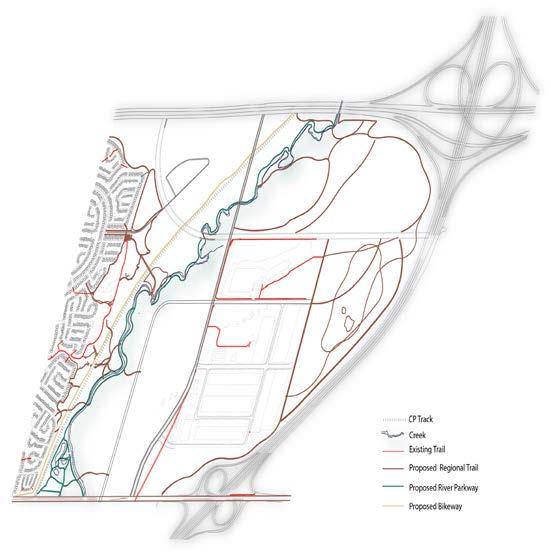
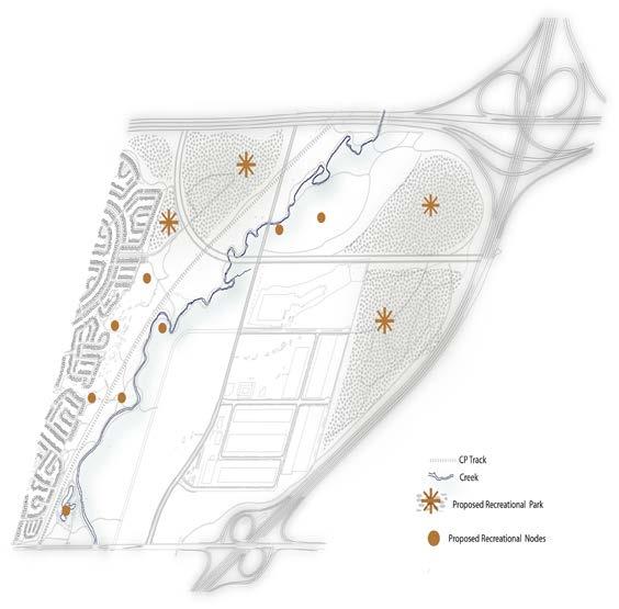
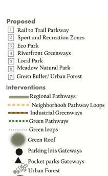
MULTI-PURPOSE TRAILS PROPOSED RECREATIONAL NODES PROPOSED NATURALIZATION ZONES PROPOSED PEDESTRIAN CROSSING & BRIDGE
The Nose Creek Corridor design prioritizes sustainability and harmonious integration with the minimal ecological impact.

Instructors: Professor Mathis Natvic
LAND 602- Plants in the Landscape Fall 2022
School of Architecture, Planning + Landscape University of Calgary
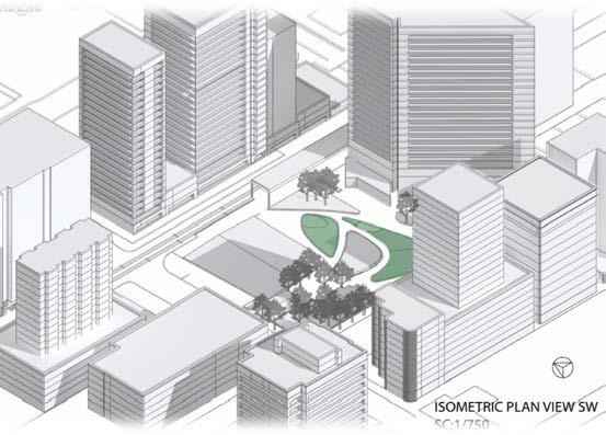
The Century Gardens Landscape Proposal presents a visionary approach to revitalizing Calgary’s urban park. Drawing inspiration from the site’s ecological past and the beauty of the prairie landscape, the proposal aims to create an inviting and ecologically rich space. By incorporating a contemporary design style and a diverse selection of perennials, the park will be transformed into a four-season tapestry of color and texture. This revitalization not only enhances the park’s aesthetic appeal but also promotes biodiversity and ecological sustainability. The proposal seeks to create a space where visitors can slow down, observe, and connect with nature, fostering a sense of appreciation for the environment. With careful consideration of local gardening requirements and the highly variable climate of the Calgary region, the selected plant species are wellsuited to thrive in the park’s context. The Proposal offers a transformative vision for the park, celebrating Calgary’s ecological heritage and creating a vibrant and welcoming space for residents and visitors to enjoy.
PROJECT. 4
PLANTING DESIGN
PROJECT OVERVIEW & SUMMARY
Century Garden,s Calgary, AB
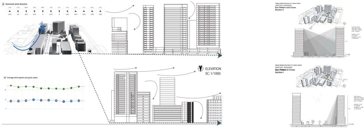
This proposal focuses on integrating a prairie concept into urban environments, using natural ecosystems as inspiration. By incorporating ecological principles and conducting site analysis, including sun and shade patterns, wind flow, and urban edge boundaries, the study aims to develop strategies for sustainable design that enhance biodiversity and the overall urban ecosystem.
GREENERY
Enhancing the existing natural elements to enhance the overall aesthetic appeal is needed
DEAD ZONE
The east corner is dead due to a vacant office and obstructed sightlines
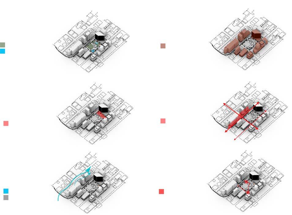
WIND CORRIDOR SHADOW
EDGE
Natural features are spread throughout the park
EDGE PATH
Major paths around the park have high use
INTENAL PATH
Needs to improve the overall user experi-
Proposed site
Location:Calgary’s downtown core
Construction: 1975
Redevelopment: 2018
Area: .7 hectares
Century Garden,s Calgary, AB
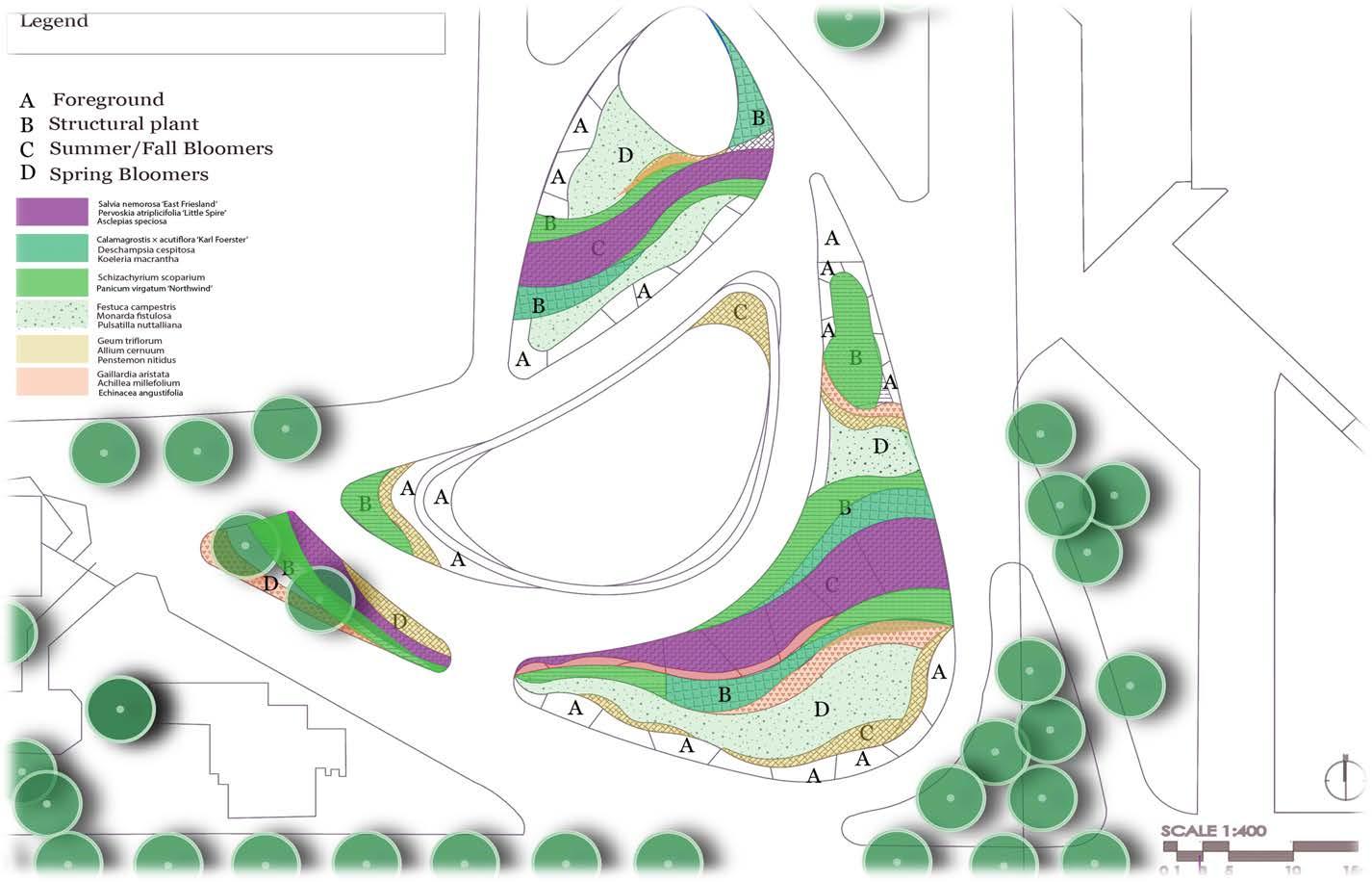
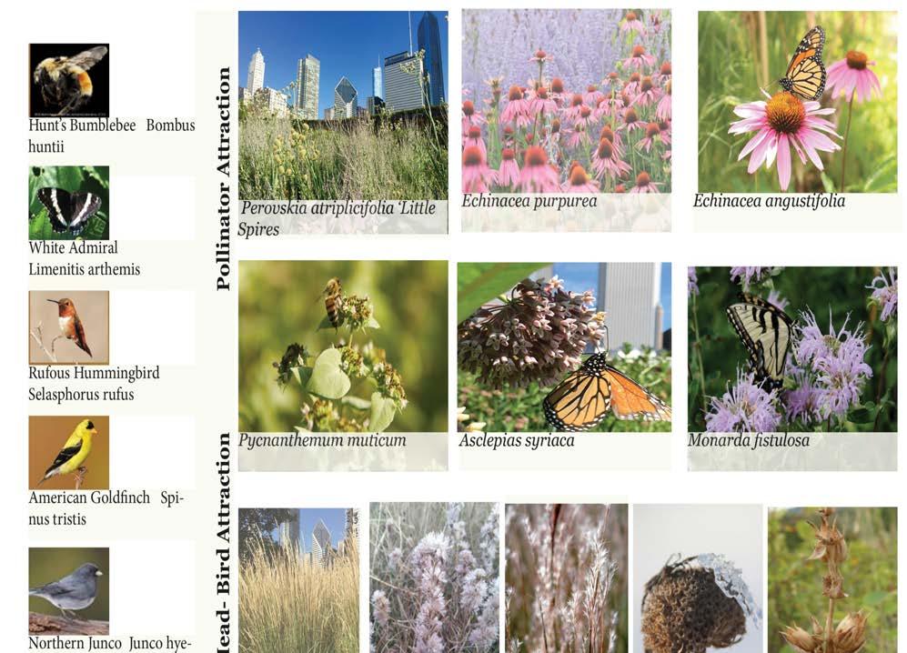
Planting Design Goals:
Evoking a prairie in the middle of the city
•Naturalistic planting/A four-seasonal palette
•Evoking a prairie in the middle of the city
•Drawing ideas from natural ecosystems as garden analogs
•Integrating ecology in the built environments
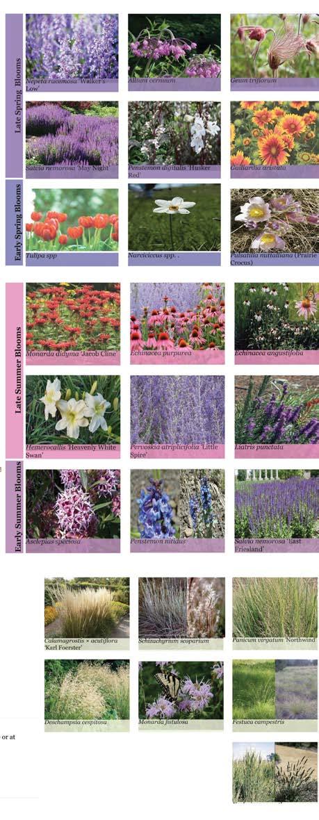
Potential plant categories:
•Flowering perennials/Native grasses & wildflowers
Key plant characteristics:
•Long-lived Bunch-forming
•Long season of interest
•Strong winter interest
•Interesting foliage texture /seed head structure
DESIGN SEQUENCE:
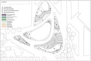
SPRING BLOOMS
Location:
• on the borders, to maintain strong visual interest
• Inter-planting with slower blooming species such as grasses
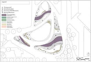
SUMMER BLOOMS
Location:
•Interspersed throughout the structural plants and away from the immediate foreground
• Visual Summer/Fall attraction
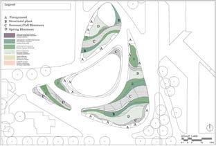
WINTER STRUCTURE:
Location:
• Center of the garden bed (the middle ground) or at the background
• Structural Plants with Winter Interest
• Long-lived Bunch-forming
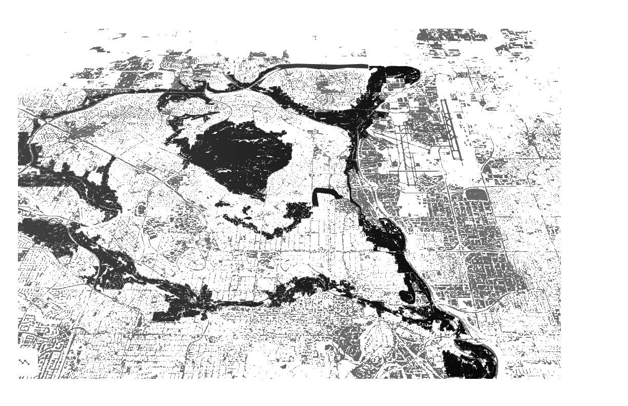
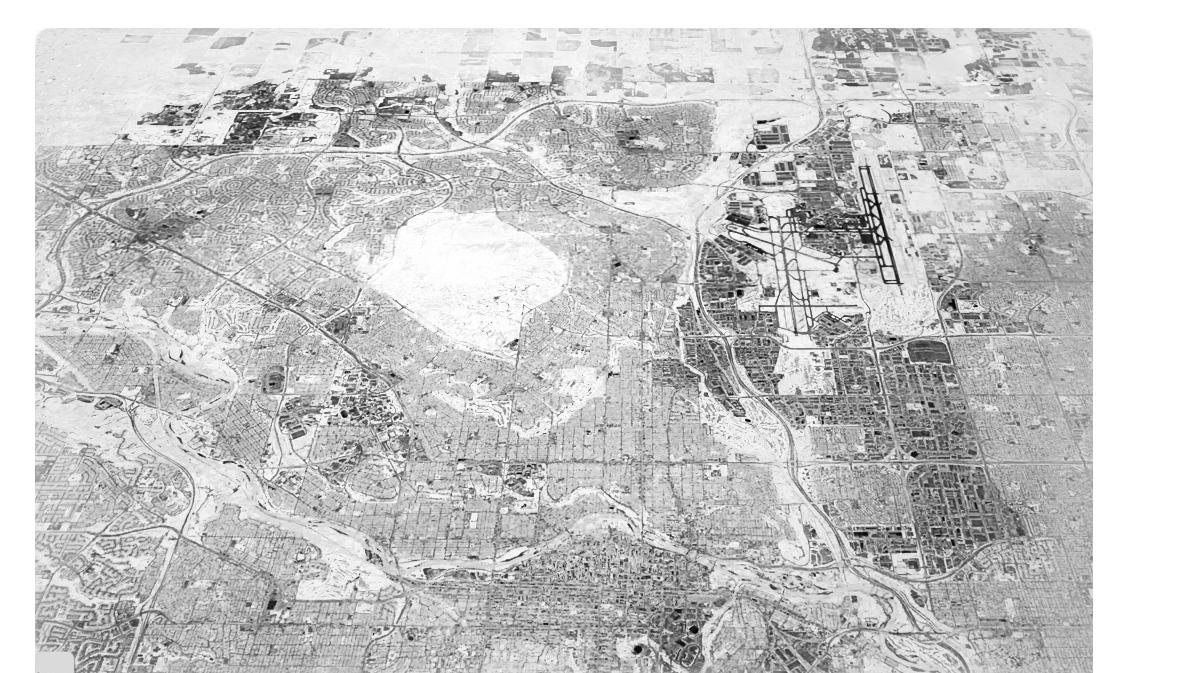
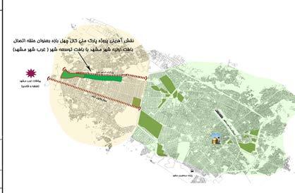
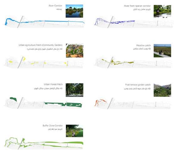
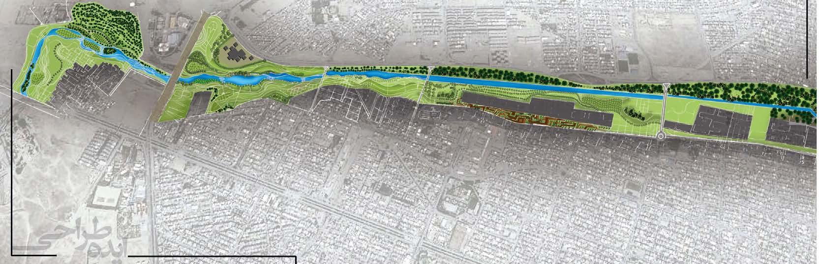
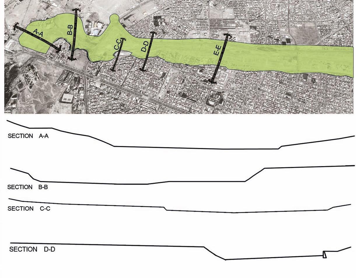
CASE STUDY: CHEHEL-BAZE , URBAN ECO CORRIDOR
South-West region of Mashhad Megacity Landscape
Thesis Research on Urban Ecological Network
Supervisor Professor Homa Irani Behbahani
Master of Environmental Design Thesis, Winter 2015
School of Environmental Design
University of Tehran, Iran
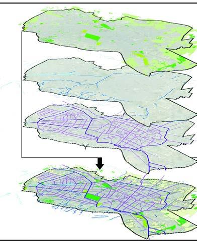
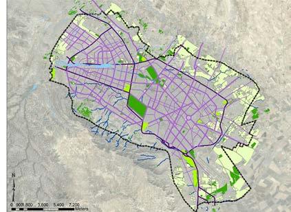
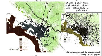
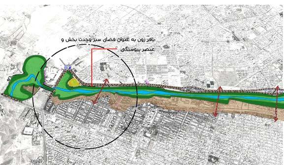
Abstract: This research focuses on the ecological dimension of sustainable urban development by utilizing landscape ecology principles to plan and design urban green infrastructures. The aim is to create an integrated ecological network that improves the structure and function of urban ecological landscapes. Using the metropolitan area of Mashhad as a case study, the research identifies the most important patches and corridors within the urban matrix. Natural and man-made corridors are found to be crucial for creating integration within the Mashhad ecological network. The proposed strategic plan emphasizes organizing and rehabilitating urban corridors to form urban greenways, enhancing connectivity and integrity in the urban ecological network. In particular, the Chehel-Baze watercourse is designed as an urban greenway using ecological interventions. Overall, this research offers strategies to enhance the urban ecological landscape structure and function for sustainable development.
KEY WORDS: URBAN GREEN INFRASTRUCTURES, ECOLOGICAL NETWORK, URBAN LANDSCAPE, ECOLOGICAL STRUCTURE, THE CITY OF MASHHAD
PROJECT OVERVIEW & SUMMARY
PROJECT. 5
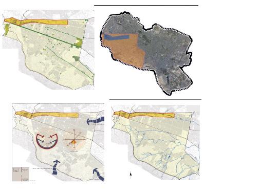
CONCEPT & DESIGN DEVELOPMENT
SCHEMATIC DESIGN
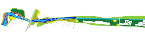
STRATEGY:
ENHANCING CONNECTIVITY AND INTEGRITY IN THE URBAN LANDSCAPE
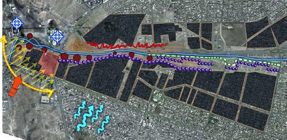

ECOLOGICAL INTERVENTIONS: INTEGRATION OF NATURE TO URBAN CORRIDOR WITH
GREENWAY
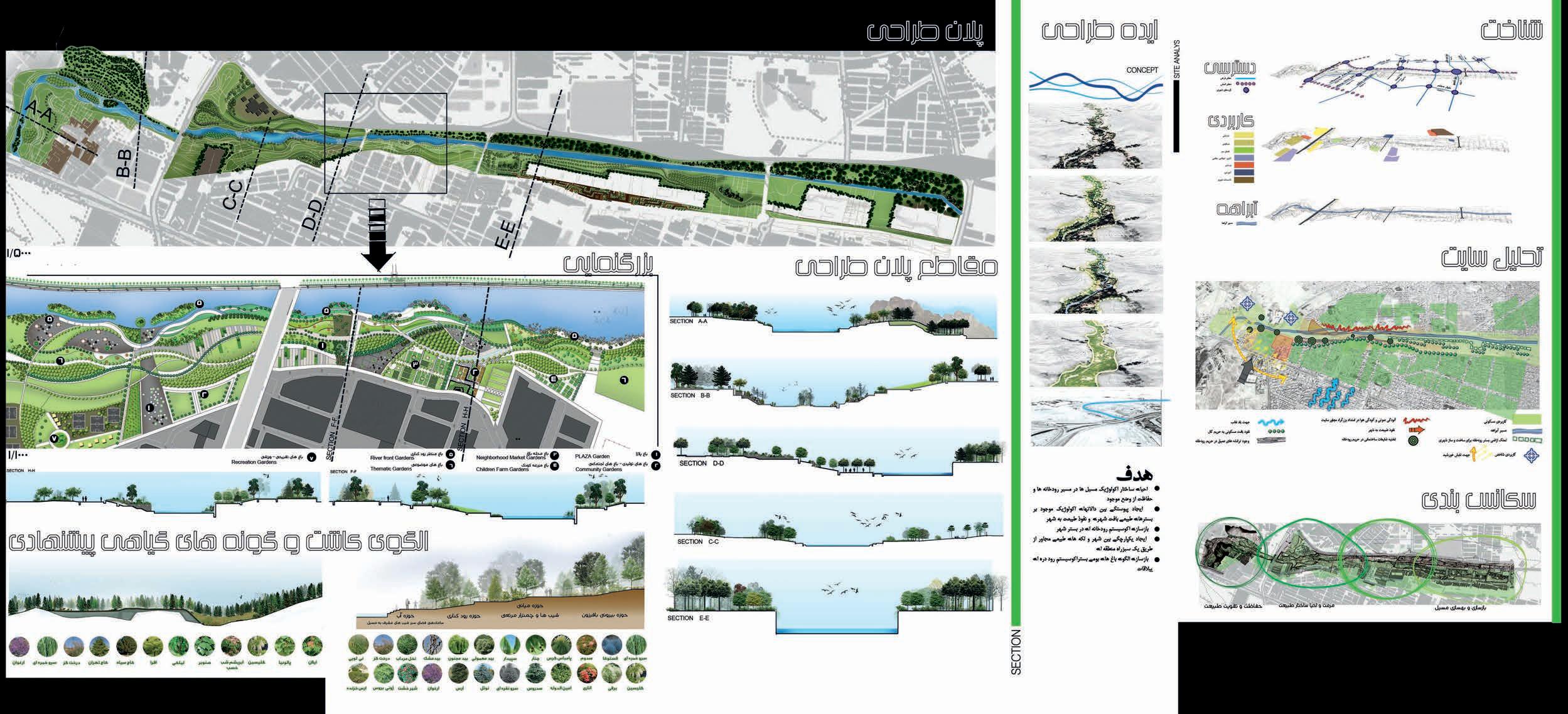
DESIGN DEVELOPMENT
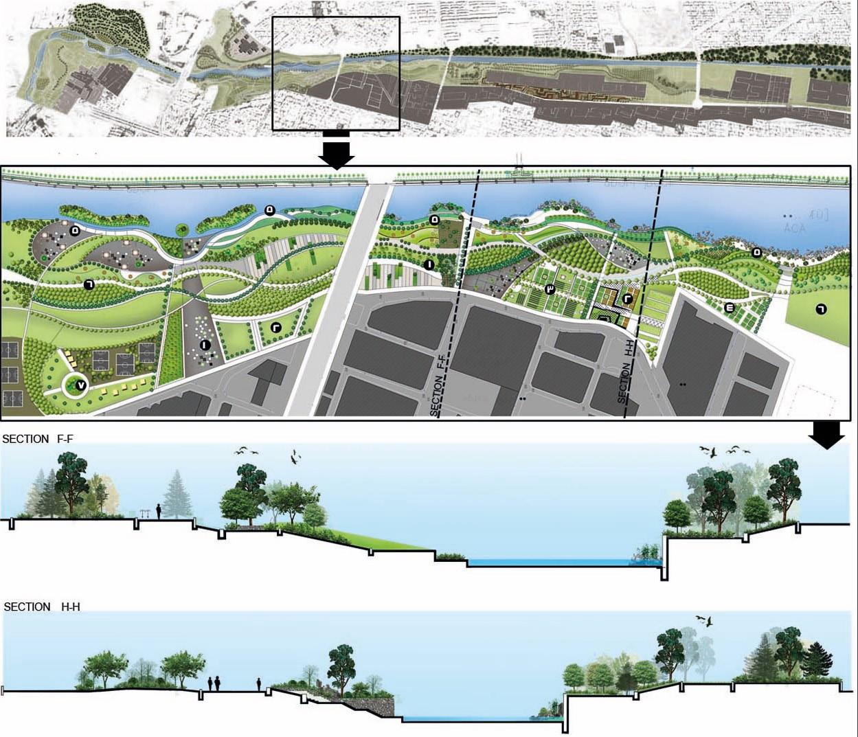
SITE PLAN SKETCH
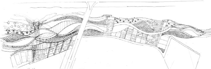
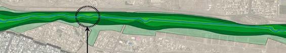
MULTILAYERED TRAIL & PARK SYSTEM
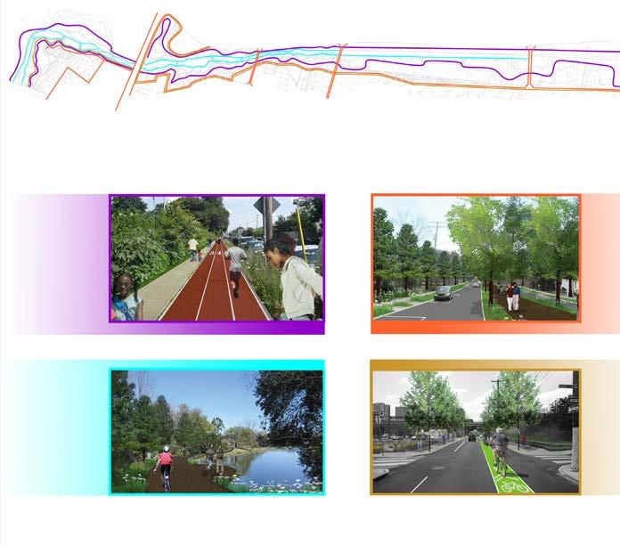
Exercise Trail
Pedestrian trail
Riverfront Trail
Cycling Trail
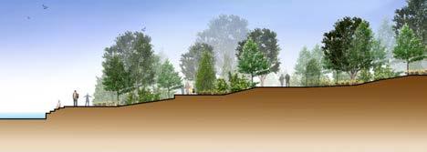
EXISTING SECTIONS
PROPOSED SECTIONS