4 minute read
UTAH'S BEST OUTDOOR DREAMSCAPES


THESE OTHER WORLDLY LANDSCAPES ARE PERFECT TO EXPLORE WITH THE FAMILY
With national parks, vast deserts that stretch on for miles, and red rock formations that look almost otherworldly in their beauty, Utah is an unforgettable travel destination that will make you feel like you've stepped foot on another planet. Whether you like hiking, relaxing, or simply taking it all in, here are a few of Utah’s most iconic locations.
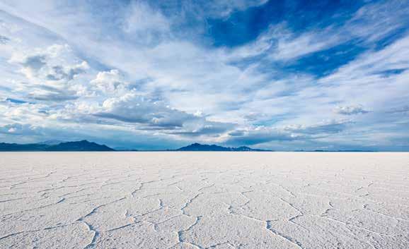
BONNEVILLE SALT FLATS, NORTHWEST UTAH
One of Utah’s most unique landscapes, the Bonneville Salt Flats, is a 30,000-acre densely packed salt pan located in Tooele County. The salt flats were created as the Pleistocene Lake Bonneville dried up centuries ago. The flats are so barren and desolate that no life forms exist, making them a favorite spot amongst photographers. While you’re out there, be sure to check out the historic Bonneville Salt Flats Race Track.
COYOTE GULCH, SOUTHERN UTAH
Nestled in the canyons of the Grand Staircase-Escalante desert, the overnight hike to the Coyote Gulch dome will leave you breathless — figuratively and literally! The trail winds through 27.2 miles of slot canyons, arches, and natural bridges. Upon your arrival, pitch your tent in the open dome and kick off your hiking boots for a walk through the Escalante River. Before heading out, make sure to score a free permit from the park service before heading off into the backcountry.
GOBLIN VALLEY, SOUTHEAST UTAH
For thousands of years, wind and water have eroded the sandstone throughout this park — leaving behind hoodoos (or rock formations) that resemble otherworldly goblins! Visitors can explore the hoodoos, hike and climb on them, or just enjoy the scenery from afar. The hoodoo formations are especially impressive when viewed from nearby high points such as Wild Horse Butte or Little Wild Horse Canyon.
LITTLE SAHARA SAND DUNES, NORTHERN UTAH
A 2-hour drive from Salt Lake City, the Little Sahara Sand Dunes look like something from Mars. Formed by the remnants of the Sevier River (which once flowed into the ancient Lake Bonneville), this 60,000 acres of sand is the perfect place for photography, sandboarding, picnicking, ATVing, or camping.
MIRROR LAKE SCENIC HIGHWAY, NORTHERN UTAH
One of Northern Utah’s hidden gems, the Mirror Lake Highway will take you 42 miles through the Uinta Mountains. Along the way, you’ll see dozens of lakes fed by the snow runoff (including the famous Mirror Lake) and you’ll have plenty of opportunities to get out and hike, picnic, or fish whenever the mood behooves you. Though the highway is often closed in the winter due to the snowpack, the highway is a local favorite for those looking to enjoy the fall leaves.
MYSTIC HOT SPRINGS, SOUTHERN UTAH
Also known as the Monroe Hot Springs, Mystic Hot Springs is one of Monroe, Utah’s most picturesque locations. Founded in 1995, the resort has 6 clawfoot bathtubs as well as two concrete soaking pools that stay heated between 99-100 degrees for ultimate relaxation.
With campsites that start at $25/ night and other concerts and events throughout the year, Mystic Hot Springs is something that you will never forget.
RED FLEET, NORTHERN UTAH
Red rocks and literal dinosaur tracks meet the water at Red Fleet State Park in Vernal, Utah, creating a scene that looks downright prehistoric (in an amazing way!). This state park is best enjoyed on a hot summer day as this location is best enjoyed in the water — swimming, cliff diving, kayaking, or paddle boarding!
REFLECTION CANYON, SOUTHERN UTAH
Reflection Canyon gained popularity when Apple used a National Geographic photo of the “canyon” as a screensaver. To reach the iconic location, you’ll have to hike 20 miles through Kanab County, giving you plenty of time to “reflect” as you put the miles behind you. Best done over a two-day period, you don’t actually trek to (or through) a canyon, but you do arrive at a gorgeous bay fed by the waters of Lake Powell.
THE SUBWAY, SOUTHERN UTAH
One of the most renowned hikes in Zion National Park, The Subway has two routes, each appealing to canyoneers or hikers. The Bottom-Up Route (Left Fork) is a 9-mile route best for those looking to hike as opposed to canyoneer. The semi-intense hike requires descending/ascending waterfalls, walking/swimming through the water in places, and even scrambling over boulders. Regardless of the challenge the hike presents, it’s worth the challenge when you see the slick slot canyon walls that literally resemble a New York subway tunnel!