
Sarantis Georgiou MSc (Hons), MArch, DiplArchEng Architect/Urbanist Engineer
Cultivated Ecologies
Operational Landscapes of Material Production as Flood-related Risk Infrastructure
This project aims to address flood-related risks by using material production and land management to create water-sensitive, sustainable, and resilient urban landscapes. It focuses on integrating agricultural and forestry practices into landscape designs that serve as flood-risk infrastructure. By analyzing the dynamics of landscape processes and patterns, the project seeks to spatially organize land cover and use to manage water sustainably.
Projective Landcape Ecological Image
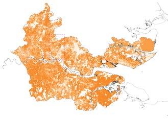
The central outcome is a “projective landscape ecological image” that illustrates how varying levels of ecological density—such as differences in land use, cover intensity, diversity, and spatial organization—can form a cohesive water-sensitive system. This approach divides landscapes into three ecological units: “patches” (discrete non-linear areas), “corridors” (linear connectors), and “matrices” (complex differentiated systems). These units are strategically deployed across horizontal and vertical dimensions to function as flood mitigation infrastructure.
By designing landscape compositions and configurations that enhance water infiltration, retention, and conveyance, the plan exemplifies how sustainable urbanization can leverage ecological principles to create resilient, multifunctional environments. This framework offers a blueprint for future water-sensitive and productive land management.
Publications & Contributions (see Annex)
Georgiou, S. (in press a), Georgiou, S. (in press b), Georgiou, S. (in press c) Georgiou, S. (2022a), Georgiou, S. (2022b), Georgiou, S. (2022c), Georgiou, S. (2021), Georgiou, S. (2020)
Conferences & Symposia (see Annex) Georgiou, S. (2022a), Georgiou, S. (2022b), Georgiou, S. (2022c), Georgiou, S. (2021), Georgiou, S. (2018)
Exhibitions & Presentations (see Annex) Georgiou, S. (2021), Georgiou, S. (2020), Georgiou, S. (2019), Georgiou, S. (2018)
Master’s Thesis for the Master of Science (MSc) degree in Architecture, Urbanism and Building Sciences (specialization: Urbanism)
Academic Programme
Master of Science (MSc) in Architecture, Urbanism and Building Sciences, Mastertrack: Urbanism
Institution Department of Urbanism, Faculty of Architecture and the Built Environment, Delft University of Technology (TUDelft), NL
Academic Year 2018-2019
Mentors dr. arch. Taneha Kuzniecow Bacchin (assistant professor), dr. Diego Sepulveda Carmona (assistant professor)
Type Landscape Ecological Planning, Water-sensitive Spatial Design, Landscape Infrastructure
Institutional Repository https://repository.tudelft.nl/islandora/ object/uuid%3Ad8569c6f-c21a-4cd2-87ff84a81797851e

Landscape Ecological Units
A projective landscape ecological image is developed as a watersensitive infrastructure by deconstructing and reconstructing its components: patches, corridors, and matrices. These ecological units, derived from the pattern:process model, form the foundation of the design’s performative potential and structural integrity. Patches are non-linear, undifferentiated elements; corridors are linear connectors; and matrices are complex, differentiated systems. Together, they enable the organization of landscapes to function effectively as flood mitigation infrastructure while supporting ecological and productive objectives.


Spatial Concepts and Models of Spatial Development
The analysis and design of water-sensitive landscapes rely on five spatial concepts: 1. the hydrological framework (following water dynamics), 2. the ecological structure/network (patches and corridors for ecosystem integrity), 3. the gradient of intensity (following surfacesubsurface water-sensitive potential), 4. the porosity/permeability (that is, the unrestricted flow of ecological density), and 5. the grid of mixité (promoting a differentiated spatial organization). These concepts guide the deployment of ecological density, integrating water management with sustainable spatial development.


2. the ecological structure corridors
the gradient of intensity matrices
the porous intensity
the grid of mixité
1. the hydrological framework patches
Figure 1.1. Projective landscape ecological image for the Border Interface Zone of the ecological region of the Greater Thames Estuary (UK), showing degrees of intensity of ecological density and corresponding configuratons.
Figure 1.2. Deconstruction of the projective landscape ecological image into its three (3) landscape ecological components.
Figure 1.3. Deconstruction of the projective landscape ecological image into its five (5) spatial concepts and corresponding models of spatial development.
Cultivated Landscape Ecologies as Landscape Infrastructural Devices
“Cultivated ecologies” describe landscapes designed to perform as water-sensitive infrastructure while increasing ecological density and supporting productive land use. These ecologies integrate morphological characteristics and programmatic objectives into functional designs, balancing ecological and operational goals.
The project identifies 24 typologies of cultivated landscapes, organized into three ecological units: “patches” (contiguous or patchwork systems), “corridors” (linear elements), and “matrix morphologies” (e.g., retention
Matrices (cultivated patchworks: woodland/cropland to cropland)


ponds, dikes). These units address water-sensitive objectives like infiltration, channelization, and retention, while enhancing ecological density through varied use intensity, cover diversity, and spatial organization.
The classifications link landscape mosaics with five criteria for ecological performance (use and cover intensity, use and cover diversity, spatial organization) and three water-management mechanisms, offering a comprehensive framework for sustainable and productive landscapes.
Figure 1.6. Catalogue of twenty four (24) cultivated landscape ecologies: typo-morphological typologies of performative ecological density.


Landscape syntax refers to the strategic and tactical deployment of cultivated landscape ecologies within a mosaic to create a cohesive, water-sensitive design. By organizing patches, corridors, and matrices, alongside vegetative cover, the approach reshapes landscapes to enhance ecological density and water sensitivity. Key goals include improving water infiltration, channelization, and accommodation, achieved through features like dikes and retention ponds. This method retrofits operational landscapes for material production, transforming their physical and structural organization while optimizing performance across use intensity, cover diversity, and spatial configuration


Design and cultivate a system of dikes and water retention ponds per: 1. coastal/tidal flood risk exposure, 2. fluvial flood risk exposure, and 3. valley and lower slope position landform morphologies, on the basis of their water-sensitive potential at protection and water accommodation.
Strengthen the system of cultivated water-sensitive landscape infrastructure for protection from coastal/tidal and fluvial flooding and for water accommodation for pluvial flooding and water run-off.
Increase the productive capacity and the heterogeneity of the landscape mosaic through patch diversification and the mixing of land-cover class types per: 1. land-use/land-cover class patch type, 2. recycling re-purposing of vacant plots, plots without current landuse and/or of isolated structures, 3. per patch size and compactness degree.
Strengthen the system of productive wooded land-cropland/pasture cover (from patchworks with intensive woodland to patchworks of extensive cropland/pasture).
Design riparian (blue-green) corridors of woodland cover (afforestation) and water channelization/conveyance per the hierarchical structure of the surface hydrographic network.
Strengthen the carrying, connecting and permeating infrastructure of cultivation and water regulation through the hierarchical nature of the surface hydrographic network (from intensive riparian forests to extensive bush/hedgerow corridors).


Design green-blue-grey corridors of woodland cover (afforestation) and water channelization/ conveyance per the hierarchical structure of the mobility network.
Strengthen the carrying, connecting and permeating infrastructure of cultivation and water regulation through the hierarchical nature of the mobility network (from intensive road forests to extensive bush/hedgerow corridors).
Introduce and/or increase cultivated patches of wooded land cover (afforestation) per: 1. land-use/ landcover class patch type, 2. recycling/ re-purposing of vacant plots, plots without current land-use and/ or of isolated structures, 3. patch size and compactness degree.
Strengthen the system of ecological, productive and water-sensitive woodlands (from intensive and polycultural patches to extensive monocultural patches).


Figure
Figure 1.8. Decomposition of
HORIZON 2020: Provide
Paris Agreement Overshooting, Reversibility, Climate Impacts and Adaptation Needs
Publications & Contributions (see Annex)
Souverijns, N. et al (in press), Davidel, R. et al (2024), Lejeune, Q. et all (2024), Capela Lourenço, T. et al (2024), Gonzales Lindberg, H. et al (2023)

The methodology addresses urban heat stress by reorganizing spaces to enhance heat regulation through shading, evapotranspiration, cooling, and air filtering. This is supported by policy recommendations targeting urban, ecological, and infrastructural open spaces, structured around five principles: 1. coherence with topography, 2. integration into urbanized landscapes, 3. porosity for accessibility, 4. flexible management for adaptability, and 5. alignment with overarching adaptation strategies.
For the Metropolitan Area of Lisbon, five strategic adaptation measures are proposed:
1. “Soil unsealing”: replacing non-paved surfaces in urban and infrastructural areas by 20%, rwith low vegetation,
2. “High vegetation expansion”: Introducing tree cover by:
- Replacing open spaces in ecological corridors with wooded areas.
- Adding trees along major road corridors to create ventilation pathways and cool urban environments.
- Developing regional systems of urban forests and parks in periurban and extra-urban areas as cooling zones.
3. “Agroforestry in flat agricultural areas”: Increasing tree cover in agricultural lands to cool crops exposed to heat stress due to geomorphology.

Professional Work Expert - Climate Adaptation and Resilience Plannning/BUUR Part of Sweco
Research Project HORIZON 2020 WORK PROGRAMME 2018 – 2020
LC-CLA-12-2020 – Advancing climate services (c) impacts of overshooting
Client CINEA - European Climate, Infrastructure and Environment Executive Agency
Duration 2021-2024
Type Spatial Planning, Research, Stakeholder Participation
Collaborators
Miechel De Paep., Severine Hermand, Mario Doneddu, and Raluca Davidel
Personal Role and Contribution all stages of the process: conceptualization, fieldwork, research, analysis, design, visualization, presentation
(here, only material developed by the author, or with the contribution of the author, are shown)
Location Metropolitan Area of Lisbon, Portugal


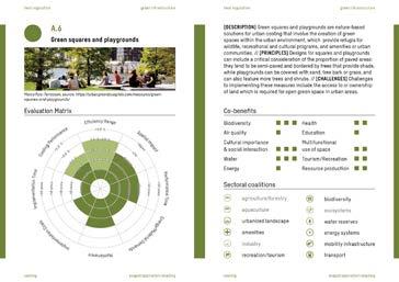


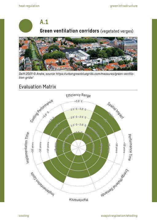
The “Description” of the measure is followed by the “Principles” and “Challenges” of its design and spatial embededness, so as to assist the relevant stakeholders and planners in their decision-making processes.
co-benefits
The section “Co-Benefits” identifies and evaluates the potential of the measure in question to provide ecosystem services other than the one/-s it is primarily used for, as well further the sustainable and resilient development of various sectors and relevant spatial planning imperatives.
The section “Evaluation Matrix” assesses the performance of the measure in question in reference to cooling, the range of global warming conditions under which it can sufficiently function, the scale of its implementation, together with its temporal, cost, maintenance and energy demands, and, finally, how long it will be until the investment will return the desired ecosystem services.
The section “Sectoral Coalitions” lists the various sectors that need to collaborate for the measure in question to be implemented both within the spatial planning regimes, as well as throughout the urbanized region.
ecosystem function (e.g. cooling) & ecosystem operation (e.g. evapotranspiration) sectoral coalitions

Figure 2.2. Greening measures: cards catalogue
service (e.g. heat regulation)
type of measure (green infrastructure)
These measures collectively aim to reduce the urban heat island (UHI) effect, improve ecological density, increase surface water, and promote air ventilation, fostering a cooler, more resilient urban environment.


The first selected hotspot in Lisbon lies in a low-density urban area of the city. Former social housing projects are the predominantly urban feature in the area, and with a very pronounced mobility axis (railway) dividing the area from West to East. The adaptation strategy developed attains a more structural character, consisting of an (almost) contiguous structure of peri-urban forest/park framing that envelops the current and future urban developments. The urban tissue (both current and planned) is infused with individual trees, cool spots and unsealed surfaces on paved areas currently dedicated to cars, urban squares or internal urban block/building courtyards.


A second selected hotspot is in the Almada area; a dense, historical urban area of the city where housing, services, education and extremely high levels of mobility are important features. The adaptation strategy consists of a generalized soil unsealing strategy with a tactical implementation of cool spaces whenever possible, while individual trees complete the picture. Unsealing and greening is proposed on paved surfaces currently utilized as car parks or squares, where it seems feasible, while ensuring connectivity whenever possible. And cooling spots are promoted in public (urban forests/parks), semi-private (internal block courtyards) and private areas (private gardens).
Figure 2.3. Strategic greening vision for the Metropolitan Area of Lisbon (upper: cummulative strategy, lower: individual measures)
Figure 2.4. Adaptation designs for the hotspot in the municipality of Lisbon, with a schematic interpretation of their principles and a typological visualization of their generic spatial impact
Figure 2.5. Adaptation designs for the hotspot in the municipality of Almada, with a schematic interpretation of their principles and a typological visualization of their
Selected hotspot 1: Municipality of Lisbon (type: low-density suburban area)
Selected hotspot 2: Municipality of Almada (type: high-density historical urban area)
Four spatial adaptation strategies to address rising temperatures are elaborated: COOL, ADAPT, PROTECT, and RETREAT, ranging from large-scale cooling projects using vegetation and water, to localized cooling solutions like green roofs when large-scale measures become infeasible, to architectural and technical solutions, focusing on shaded and indoor environments, and, finally, to abandoning overheated urban areas for cooler regions, based on different climate scenarios, in reference to warming and overshoot conditions. The development of adaptation narratives follows a systematic analysis of the current and future structure of the built environment.


technical, structural and architectural solutions
avoidance of parts of the city during times of the day, increase in indoor environments and punctual engineered cooling solutions
arcades and covered walkways, shading cooling building structures, watering sprinklers, foggers or fountains


move and/or opt for different urbanization
adaptation to heat is unfeasible, and the energy and material demands and costs for indoor cooling are unreachable


‘offensive’ cooling spatial planning
large-scale increase in different intensities of vegetated and surface water land cover


(from lush forests to generalized soil unsealing, and from big ventilation corridors to a complete tactical provision of cool spaces)


abandonment of existing urban areas, urbanization of higher altitudes, vernacular architecture, tactical deployment of cooling measures green roofs and facades, strategic cool places, soil unsealing, high albedo materials, changes in agriculture
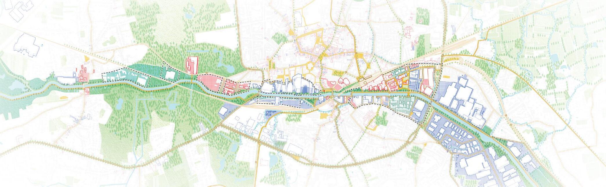
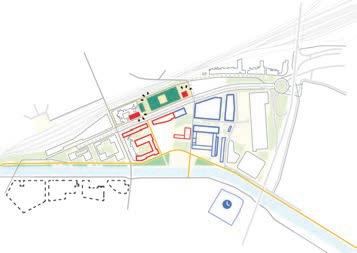
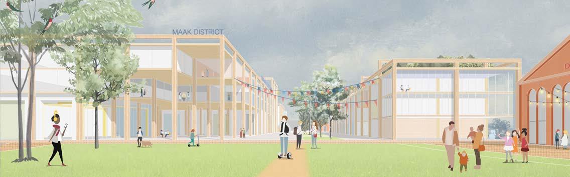
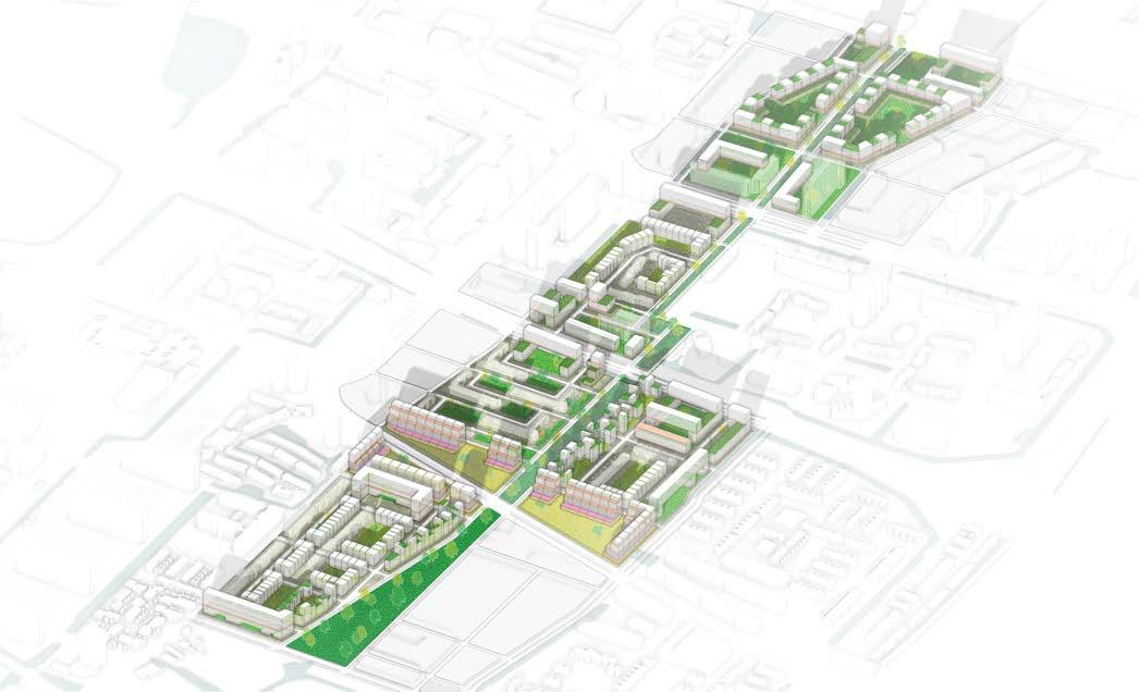
Tragel in Transition
Integrated Spatial Framework for the Co-Creation of Tragel Circular District


“Tragel in Transition” outlines the transformation of Tragel Zuid into a dynamic Makers District, revitalizing the Quays and Dender waterfront and enhancing Aalst’s urban and territorial identity. The plan emphasizes ‘urban circularity’ through a framework fostering collective interactions and sustainable development. Four core ambitions—an inclusive neighborhood, productive district, connected networks, and a healthy environment—shape the transition. These ambitions address ecological regeneration, flexible/multifunctional spaces, accessible public areas, and improved public mobility.
The initiative combines these aspects into a matrix of 16 strategies and 48 actions, enabling a phased, incremental transformation. This
Dender-Aalst Regional Plan
Europan 16
Duration
approach offers both a visionary roadmap and practical tools for stakeholders to collaboratively envision, plan, and implement the transition, ensuring Aalst’s river-city relationship and ecological resilience are strengthened. Tragel Zuid Spatial Framework
Development is anchored on heritage activation

Collaborators
Felipe Chaves Gonzalez, Preetika Balasubramanian, Jiska Gisels, Lucas Di Gioia
Personal Role and Contribution
conceptualization, research, analysis, methodology development, spatial measures elaboration, regional design, spatial framework design, masterplan design, visualization, presentation
(only material developed by the author, or with the contribution of the author, are shown)
Location Aalst, Belgium


Network of site- and city-wide connections Robust green-blue ecological framework

Individual platforams compose a unified site


Circular transitions across the site
Tragel Zuid Masterplan

PHASE 0
Preparing the ground
The car-aligned ‘no-one’s’ land gets re-oriented and rediscovered due to the New Tragelweg. Meanwhile, ambitions for the Tragel-Noord area are being raised, increasing flexible future use.

PHASE 1
Connecting the city
Interconnecting city-wide mobility networks, adding a temporary bridge. “Stroom vzw” moves its activities to the future mobility hub, functioning as a garage and material hub.

The Tragel Circular Transition vision enables subsidies across domains. Anchored legally by the city, the plan fosters collaboration among stakeholders, emphasizing “slow urbanism”, and long-term district transformation led by an independent director.


PHASE 2
Inviting the makers
Enhanced site-visibility along the New Tragelweg and flexible spaces, offer great conditions for start-ups. Temporary events in heritage buildings, invite people and increase appreciation.


Inclusive Neighbourhood Connected Networks Productive District Healthy Environment
An inclusive Tragel Zuid is where different people are invited to co-exist through living, working, and learning facilities. This is given to the inhabitants of the site through their participation in the creation of their daily lives.
A waterfront that is accessible and connected to the city is there for the people to meet, stay, work, relax, play and experience their environment, while smart logistics routes make its functioning seamless all day long. Making and creative economies revitalize the urban condition, through flexible and multifunctional use of its building stock, integrating its industrial heritage and welcoming its inhabitants to cocreate their environment.
The new Tragel Zuid is a livable space: inhabitants grow their own food, physical and mental health is catered for through sporting facilities and the abundance of green and blue, and the spaces are spaces that belong to the people.
PHASE 3
Embracing the Dender
Housing developments ensure the construction of an improved waterfront experience: an open space public platform around heritage buildings, where people meet and connect with the water.

PHASE 4
Cultivating the lifestyle
The flexible structure and strategic location of Tragel-Noord, offers possibilities to expand the circular district through an innovative food factory, where health and research come together.
PHASE 5
Expanding the transition
Continuously reflecting on and expanding the approach to nearby sites ensures conditions for circular transitions. Users are able to move across locations, broadening their network.


REGENERATIS
Regeneration of Past Metallurgical Sites and Deposits through innovative circularity for raw materialsinnovative materials
A systemic framework for landfill and PMSD site redevelopment addresses legal, financial, organizational, informational, and planningrelated barriers, offering strategies to overcome them. It encompasses vision development, drafting plans, implementation supervision, actor management, and quality control. The process is structured around three interconnected themes:
1. Ambitions – defining project incentives, goals, and success metrics.
2. Planning and Design – translating analysis into legal documents and construction plans.
3. Decision-making and Participation – facilitating stakeholder collaboration and integrating expertise.
These themes ensure alignment between content (materials, substances) and context (urbanization trends, climate change), forming the basis for integrated projects. The framework serves as a guiding tool to identify barriers, an evaluation mechanism to assess alignment with project goals, and a platform for stakeholder dialogue to enhance integration.


Professional Work Expert - Climate Adaptation and Resilience Plannning/Spatial Research at BUUR Part of Sweco
Research Project Interreg - North-Western Europe
Client OVAM - Openbare Vlaamse Afvalstoffenmaatschappij
Duration 2023-2024
Type Process Architecture
Collaborators
Felipe Gonzales, Kathleen Van De Werf
Personal Role and Contribution all stages of the process: conceptualization, fieldwork, research, analysis, design, visualization, presentation
(only material developed by the author, or with the contribution of the author, are shown)
Location Flemish Region, Belgium (BE)


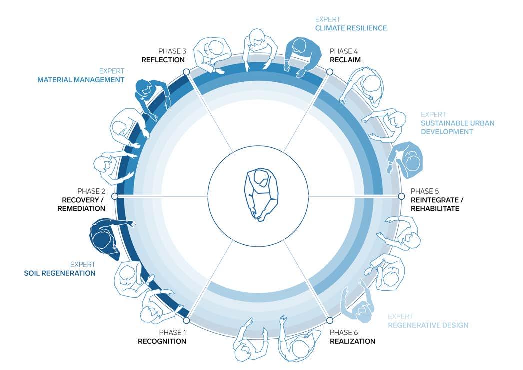
Figure 4.1. Track A of the planning methodology illustrating the overall objectives of the project (source: Sarantis Georgiou and Felipe Gonzalez)
Figure 4.2. Track B of the planning methodology illustrating the planning and design process of the project (source: Sarantis Georgiou and Felipe Gonzalez)
Figure 4.3. Track C of the planning methodology illustrating the co-production process of the project (source: Sarantis Georgiou and Felipe Gonzalez)
The process unfolds across six phases, interconnecting the tracks. The ambitions track evolves from understanding challenges to establishing a guiding evaluation matrix. The planning track progresses from analysis and research-by-design to spatial and legal plans. The co-creation process begins with defining ambitions and managing stakeholders, moves through collaborative planning, and concludes with a comprehensive plan for approval and implementation.
This interconnection enables the identification of opportunities, alignment of objectives, and a structured approach to tackling redevelopment challenges. By synthesizing distinct storylines and engaging with stakeholders, the framework fosters transparency, alignment, and effective realization of landfill and PMSD redevelopment projects.

Figure 4.4. The process architecture of the project, bringing together the objectives, the planning and design, and the coproduction processes (source: Sarantis Georgiou and Felipe Gonzalez)
A8 Halle Study Mission


Professional Work
Expert Urbanist - Climate Adaptation and Resilience Plannning/Spatial Research, at BUUR Part of Sweco
The A8-Halle project aims to integrate road infrastructure into its surroundings, improving sustainable mobility and quality of life. A spatial framework, comprising a “hard backbone” (sustainable mobility infrastructure) and a “soft backbone” (landscape and ecological integration), guides this effort. The hard backbone focuses on redesigning roads for pedestrians, cyclists, and local traffic, while the soft backbone emphasizes green and blue infrastructure, ecological connections, and natural systems.
Key strategies include restoring urban fabric, enhancing green-blue networks, and reconnecting fragmented urban and natural areas. The project identifies structural elements, strategic zones, and sub-zones where interventions can maximize connectivity and leverage the A8’s potential as a catalyst for sustainable development. Efforts prioritize aligning mobility solutions with spatial and ecological conditions, fostering interaction between people and nature. By integrating urban and ecological goals, the A8-Halle project seeks to create a cohesive, livable, and environmentally connected urban area.
Client De Wekvennootschap
Duration 2022-present
Type
Infrastructural Planning
Collaborators Mikel Fernandez, Philippe Loomans
Personal Role and Contribution spatial research, research-by-design methdology development, spatial analysis, spatial planning, preliminary spatial design, visualization
(only material developed by the author, or with the contribution of the author, are shown)
Location Halle, Belgium (BE)


Figure 6.1. Synthesis of the hard and soft backbone with indication of sub-zones as a spatial framework for the A8 (source: Mikel Fernandez and Sarantis Georgiou)
Figure 6.2. An integrated spatial vision for the A8 project based on the interaction between people and nature as a response to the leverage function of the A8 for more sustainable mobility and a better quality of life. (source: Sarantis Georgiou and Felipe Gonzalez)
Figure 6.3. Schematic representation of the steps in deriving the spatial framework with criteria and research window for the design research. (source: Sarantis Georgiou and Mikel Fernandez)
Restoration urban fabric
Existing and planned activities are concentrated centrally within the eastern part of the A8 between the city center and Essenbeek.

people people
Green-blue networks
The existing and potential links in a greenblue network are located on the edges and in the neighborhoods.

people nature

Fewer connections on the A8

Guidance through the neighborhoods to the A8

Bottlenecks in the buildings along the A8

Need for good cross connections


Support functions for A8 Restore tissue and open space

Ecological connections
Natural values a re located on the edge of the urban area and are connected to the area surrounding the A8 and the Zenne Valley.

nature nature

Safe comfortable routes Open visual relationships along the A8


Defragmentation Possible rest and diversion points


Connection of open spaces via A8 System of stepping stones


Figure 6.5. Result of the exploratory study (source: Mikel Fernandez and Sarantis Georgiou)
Climate City Contract Leuven
Framework for the Circular Transition of the Building Materials and Plastics Sector for the City of Leuven
Leuven is advancing the circular construction materials sector through pilot projects, including the “Materialenbank” and “Urban Resource Centre.”
The project focuses on:
1. Selective demolition and renovation, identifying and processing materials effectively.
2. Value chain integration, linking material suppliers, processors, and endusers.
3. Market development, creating demand for recovered secondary materials.
Success depends on aligning stakeholders, developing infrastructure (e.g., storage and processing facilities), optimizing logistics, and implementing well-monitored demolition and renovation plans. By fostering collaboration and building a circular economy framework, the project aims to establish a scalable market for processed construction materials.
As a test case, it investigates the conditions for success and informs a comprehensive Waste & Circularity policy and upscaling plan. This framework is built on three building blocks to ensure sustainable material reuse and management in Leuven.

Professional Work
Expert Urbanist - Climate Adaptation and Resilience Plannning/Spatial Research, at BUUR Part of Sweco
Research Project Climate CIty Contract
Client Stad Leuven
Duration 2023-2024
Type Transition Framework
Collaborators
Felipe Gonzales, Kathleen Van De Werf
Personal Role and Contribution conceptualization,, research, analysis, framework development, visualization, presentation
(only material developed by the author, or with the contribution of the author, are shown)
Location Leuven, Belgium (BE)
WHICH ARE THE NECESSARY
WHAT ARE THE REQUIRED EXPERTISE? WHO SHOULD BE INVOLVED? WHERE TO INTERVENE? WHAT ARE THE NECESSARY SPACES?
A material value chain is mapped to identify key phases and subphases, enabling the transition from linear to circular processes. This approach prioritizes value retention and minimizes material and resource loss using the hierarchical “R ladder.” It guides process priorities and highlights complementary opportunities. Each phase structures material assessment procedures to evaluate and monitor the value chain’s condition, identifying necessary changes to enhance sustainability and efficiency.


Figure 6.6. The theoretical components of the transition framework that bring together the value chain, the actors involved in its circularization and the spatial conditions, infrastructures and logistics systems that participate in the circular transition (source: Sarantis Georgiou and Felipe Gonzalez)
Figure 6.7. Schematic representation of the circularization of a linear
(source: Sarantis Georgiou and Felipe Gonzalez)
Competence domains and values are linked to value chain steps to define stakeholder roles and address expertise gaps, mindset barriers, and governance challenges. This process identifies partnerships and collaborations aligned with “R” strategies for closing loops. By connecting complementary domains across scales and expertise, stakeholders are directly linked for management and implementation. Subdomains serve as guidelines for investigation and highlight focus areas during the transition to a circular value chain.


A spatial translation of a circular plastics system integrates infrastructure, logistics, and value chain scales. It identifies spatial conditions for stakeholder and procedural synergies to enable ‘R’ strategies across the chain. Space bridges material lifecycle and stakeholder mapping, aiding systemic implementation. Project viability hinges on infrastructure efficiency, cost, and community development considerations.


Figure
Figure 6.11. Schematic representation of the logistical interconnectedness of circular infrastructures through the various scales within and throughout which the circular value chain operates (source: Sarantis Georgiou and Felipe Gonzalez)
Water Binding Time
Redevelopment of a part of the historic centre of Florina city, around Sakoulevas river
Exhibitions
Department of Architecture, Faculty of Engineering, University of Thessaly. (2015 November 4 – 2015 November 26).
Master’s Thesis/Diploma Project for the Integrated Master/Diploma degree in Architecture/Architectural Engineering (MArch, Dipl. Arch. Eng.)
Academic Programme
Integrated Master’s/Diploma in Architecture/ Architectural Engineering (MArch, Dipl. Arch. Eng)
The proposal aims to integrate Florina’s historical legacy into the city’s everyday life by regenerating a neglected part of the urban fabric. The city has undergone significant changes through its history, shaped by the Ottoman period, World War II, and migrations. Despite these transformations, the Sakoulevas River, which flows east to west through the city’s southern part, has remained a constant element.
Currently, urban functions are concentrated north of the river, leaving the riverbanks underutilized. Yet, key remnants of the city’s Ottoman-era history are situated near the river. The proposal centers on integrating three historical building remains along the Sakoulevas River into the city’s everyday use. This area, marked by low activity, provides an opportunity for innovative design to bridge historical significance and contemporary functionality.
The plan introduces two interrelated routes: a “historical” route connecting the three sites of interest and a “pedestrian riverside walk.” The historical route focuses on enhancing the prominence of the Ottoman remains, linking the city’s past to its present. The riverside walk emphasizes the linear flow of the landscape, relating users, the river, the urban environment, and the natural surroundings.
These routes intersect to merge daily routines with historical discovery, fostering a dynamic interaction between citizens, visitors, and the city’s cultural heritage. By revitalizing the riverbank and connecting it to Florina’s historical fragments, the proposal aims to reclaim this area as a vibrant, multifunctional space that honors the city’s identity while addressing modern urban needs.
Institution
Department of Architecture, Faculty of Engineering, University of Thessaly, GR
Academic Year 2014-2015 Spring Semester
Supervisor Evelyn Gavrilou (assistant professor)
Type Urban Design
Collaborator Aikaterini Dimoula
Personal Role and Contribution
conceptualization, fieldwork, research, spatial analysis, spatial design, visualization, presentation (only material developed by the author, or with the contribution of the author, are shown)
Location Florina city, Greece
Institutional Repository Georgiou, S. Dimoula, A. (2015). Redevelopment of a part of the historical centre of Florina city around Sakoulevas river [Diploma project, University of Thessaly]. University of Thessaly Institutional Repository. http://hdl.handle.net/11615/45927

Overall Design Strategy
The design strategy highlights integrates its architectural monuments into daily urban life, by revitalizing a neglected riverine segment, a consistent feature in the city’s history. This hybrid urban and landscape design approach enhances the segment’s functionality and historical significance.
A riverine promenade emphasizing the natural landscape and a historical route linking the three monuments with targeted site interventions, are proposed. These routes intersect, creating a seamless connection between historical discovery and everyday use, enriching the urban experience while honoring the city’s cultural heritage.

Strategies


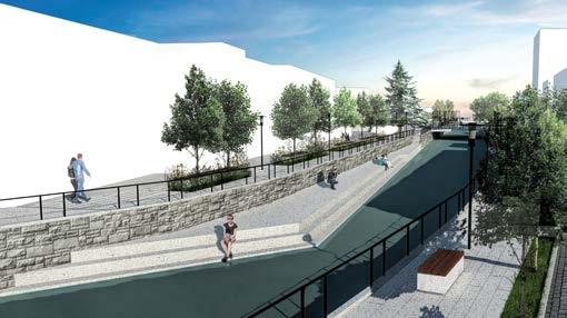
Figure 7.1. Photorealistic impression for the Ottoman bathhouse (‘hamam’) area (credits: Sarantis Georgiou and Aikaterini Dimoula).
Redevelopment
Figure 7.2. Masterplan of the redevelopment design with emphasis on individual spatial interventions.
Figure 7.3. Component redevelopment strategies and tactics for the overall redevelopment urban design project.
Urban plaza/square at the Ottoman bathhouse (‘hamam’) area


The Ottoman Bathhouse area is redesigned as a small plaza/square, occupying what is now an almost abandoned open urban space. The area forms a relationship with the water through a stepwise platform descending to water level, creating a a variable interaction with the water: during high tide season, the water enters the public realm.
Perforated platform for the appreciation of the water and the surrounding landscape
impression


A platform is proposed just above the body of the water of the river so as that an adequate space for the viewing experience of the extra-urban landscape is established. The platform is perforated in order to provide the necessary contradiction between the mountain and the river, as well as for continued interaction with the water.
Fragment of mosque tower (‘minaret’) area


Diminished platform for the appreciation of water and the urban landscape at ‘Aristotelis’ cultural center area
plan photorealistic impression


The route is divided into two different levels, with the newly introduced one being on the water so as to act as a new viewing angle towards the surrounding urban landscape Furthermore, the sense of seclusion is enhanced with benches facing towards to opposite building while at the same time being surrounded by trees.


The other edge of the site is redesigned as a small plaza with the aim of enhancing both the experience of the ruins as well as to be an open public urban space. Finally, another currently underutilized open space is redesigned as a small park.


Figure 7.4. Plan (credits: Sarantis Georgiou), and impression and programmatic detail (credits: Sarantis Georgiou and Aikaterini Dimoula) for the Ottoman bathhouse (‘hamam’) area.
Figure 7.5. Plan (credits: Sarantis Georgiou), and impression and construction detail (credits: Sarantis Georgiou and Aikaterini Dimoula) for the perforated platform for appreciation of water and surrounding landscape area.
Figure 7.6. Plan (credits: Sarantis Georgiou), and impression and construction detail (credits: Sarantis Georgiou and Aikaterini Dimoula) for the fragment of an Ottoman mosque tower (‘minaret’) area.
Figure 7.7. Plan (credits: Sarantis Georgiou), and impression and construction detail (credits: Sarantis Georgiou and Aikaterini Dimoula) for the diminished platform for appreciation of the water and the urban landscape at the “Aristotelis” cultural area.
Figure 4.5. Plan (credits: Sarantis Georgiou), and impression and construction detail (credits: Sarantis Georgiou and Aikaterini Dimoula) for the wall fragment of an Ottoman aristocratic residence area.
Figure 7.8. Impression of the urban park/forest, and tree and material detail (credits: Sarantis Georgiou and Aikaterini Dimoula).
N
Sarantis Georgiou Portfolio
Sustainability Impact Tool
The Sustainability Impact Tool is a holistic framework with the aim to integrate sustainability components within projects. From conceptualization and planning, to execution and delivery, the tool assists not only in the setting of sustainable ambitions, but, also, in the monitoring of their evolution and the dissemination of their results. It encompasses six fields: impact on Environment, Society, Economy, and Spatial, Process and Technical quality (ranging from such issues as the quality of water, economic prosperity and social inclusion, to the flexibility of the planning and design process, the use of materials throughout its life-cycle and the user experience) that, together, form the various aspects that contribute to the sustainability of a project. The tool can be used alongside the stages of a project and regular evaluations and reporting phases are used in co-creation with the relevant stakeholders.
Professional Work Expert Urbanist - Climate Adaptation and Resilience Plannning/Spatial Research, at BUUR Part of Sweco
Client SWECO (internal project)
Duration 2022-present
Type
Sustainability Reporting
Collaborators
Miechel De Paep
Personal Role and Contribution research, literature review, conceptualization, drafting, framework development, testing, visualization, presentation, teaching
(only material developed by the author, or with the contribution of the author, are shown)


Each component is evaluated in different phases based on determined criteria and descriptions that fit the various legal and procedural instruments.

monitoring
The evolution of all sustainability components can be gauged throughout all phases of the execution of the project (from ambition setting, to intermediate evaluations, all the way to the evaluation of the final product deliverable).
For the purposes of reporting and communication, a comprehensive report is automatically created with different levels of detailing that correspond to different needs of dissemination.
topics,
The


Diffuse Energy
Contextualizing the production and distribution of energy, the case of the Veneto region, Italy
This research and design project focuses on planning and implementing a new energy system in central Veneto, specifically between Porto Marghera and the Metropolitan Area of Venice. The proposal addresses various contextual factors such as urbanization patterns, environmental data, and ground conditions. The emphasis is on creating a public, decentralized energy system that enhances environmental quality while promoting energy autonomy across manufacturing and logistics hubs in the region.
The project aims to recycle unused or under-utilized infrastructure and employs a “territorialization” approach, beginning with the manipulation of the hydrographic system. A regional reforestation project will follow, eventually leading to the development of hubs and their networks. The decentralized energy system will contribute to a more balanced regional economy by fostering further dispersion and diffusion, aligning with the evolving demands of the regional and national economy. This approach seeks to advance the already dispersed territorial economy of Veneto.
Focusing on further establishing conditions of dispersion and diffusion, the proposed decentralized-distributed energy system is set to promote an even more flattened territorial economy, hence, to contribute in the continued progress of the territorial project of the Veneto region by responding to changes that have occurred in the regional and national economy these past few years.
Restructuring the ‘Città Diffusa’: territorialization and urbanization
The project uses infrastructure as a backbone for urbanization, triggering renewed land appropriation by integrating everyday qualities.

Decentralized and Distibuted Network System Configurations
The energy system is decentralized with autonomous hubs exchanging power, with Porto Marghera providing support during energy deficits.
Spatial Design
The project includes regional reforestation for biomass, hydroelectric power production, phytoremediation for environmental mitigation, water management for hydraulic risks, recycling and re-appropriating existing infrastructure, and energy production hubs located at key sites. These interventions aim to support a decentralized energy system while addressing environmental concerns and utilizing available resources effectively.
Research and Design Studio Infrastructure and Environment Design (IED)
Academic Programme
Master of Science (MSc) in Architecture, Urbanism and Building Sciences, Mastertrack: Urbanism
Institution
Department of Urbanism, Faculty of Architecture and the Built Environment, Delft University of Technology (TUDelft), NL
Academic Year 2017-2018 Spring Semester/Q4
Mentors dr. arch. Taneha Kuzniecow Bacchin (assistant professor), dr. Hamed Kosravi (assistant professor), ir. Filipo Lafleur
Guest Tutors and Critics dr. Paola Vigano (professor)
Type
Landscape Infrastructure, Water-sensitive Planning/Design/Engineering, Strategic Spatial Planning, Tactical Spatial Design
Location
Marzenego river basin, Veneto region, Italy


Figure 9.3. Spatial design (strategic and tactical) for the ‘città difusa’.
Figure 9.4. Spatial design (strategic and


Water Management Mechanisms, Landscape Infrastructure Elements and Multifunctional Device Typologies
The project proposes a comprehensive approach to water management, integrating landscape infrastructure and multifunctional devices. It begins by enhancing the river’s riparian zone for programmed flooding, utilizing the site’s topography and canal system, including weirs and dams for hydroelectric energy production. The project involves a series of water management mechanisms to regulate water influx, discharge, and remediation of contaminated soil and water: a network of water management devices, including riparian zone augmentation, ditch networks, and flooding plains, addresses flood risks and soil/water remediation. Defunct quarries and landfills are repurposed for water management, remediation, and public spaces.
These interventions are coupled with a regional reforestation project, which supports energy production, public space creation, and risk mitigation, ensuring environmental sustainability and community benefits across the territory. The overall approach enhances both ecological and urban resilience through multifunctional infrastructure.


Figure 9.5.
network conditions) bear the overflowing of water from the Marzenego river.
Figure 9.6.
Figure 9.7. Multifunctional landscape infrastructural programmatic device typologies for different site conditions: cropland, riverine, sub-urban and
Transitional Surfaces
a mobility-infrastructure-based framework for the redesign of Delft South-East, as a medium for residential densification and programmatic intensification and diversification
The city of Delft faces challenges related to its urban plan and built environment. With a projected population increase, there is a need for densification, particularly in residential space, and for the integration of various urban programmes. However, much of the area outside the historical center is developed with programmatic segregation, requiring a greater mix of uses.
This studio project addresses both densification and the diversification of land use through an infrastructural approach. It proposes redesigning the mobility network as a tool for urban renewal, using mobility infrastructure as the foundation for land use, built form, occupancy, and property development.
Research and Design Studio Designing Urban Environments
Academic Programme Master of Science (MSc) in Architecture, Urbanism and Building Sciences, Mastertrack: Urbanism
Institution Department of Urbanism, Faculty of Architecture and the Built Environment, Delft University of Technology (TUDelft), NL
Academic Year 2017-2018 Autumn Semester/Q2
Tutors ir. Marco Lub (teacher)


the Netherlands

programmed roofs
Further to the imperative for programmatic intensification and diversification, public and/or collective space is extended vertically to the roofs of the built form. Such urban gardens are perceived as a second field of urban life, and are structured according to the rhythmic hierarchy of the built form configurations.

Built form is programmed on the basis of a hierarchically organized mixed-use pattern.


built form
The volumetric diversification of the built form is based on both courtyard-like as well as permeable configurations. Thus the new plan allows for increased efficiency in the use of space and, what is more, an augmented potential for programmatic diversification. Typologies and programme follow the overall rhythmic hierarchy.
Open space is conceived of as a network of disparate elements on the basis of 3 aspects: 1. the urban forest device that both permeates and connects the entire plan, 2. the differentiation between 2 fields of occupation, and 3. the programmatic diversification between urban forest, urban plaza/square, urban parks and urban gardens. The overall plan intensifies the use of open space through its connection with the built form and the hierarchy of rhythms on which the plan is based. open space
blocks and built-form footprint
Urban blocks are formulated through a clear layout, with the aim of overall intelligibility of the urban plan. The footprints of the built form are structured around the permeability of the urban plan, while both follow a rhythmic hierarchy.
Figure 10.3. Exploded axonometric representation of
Multi-modal Public-transport-, Bicycle- and Pedestrian-based Mobility Network as Structuring Infrastructure of Movement and Programme
The mobility infrastructure is central to organizing the urban plan, emphasizing mass transport, bicycle, and pedestrian mobility. Six different street types are proposed to serve both mass transport and car mobility while promoting bicycle and pedestrian movement throughout the urban area. These streets are designed to align with various elements of the urban plan, such as land use, land cover, built form, occupancy, and property. This approach ensures a balanced, multi-modal mobility network that structures the movement and programming of the city.


The project is implemented in three stages: the creation of a new urban core, development of elements along the axis, and completion of the urban fabric to connect all parts. The residential built stock is reorganized progressively, starting with fewer units and increasing in number towards the end. This phased approach allows for ongoing evaluation of the proposal’s implementation, ensuring the urban plan evolves cohesively while accommodating the increasing residential demand.
structuring the south-east axis connecting the parts


photorealistic impressions


Figure 10.7. Phasing of the implementation of the project, with emphasis on the changes in the housing stock (total
Figure 10.9. View of the urban plaza/square with emphasis at the public space of the plaza/square area.
Figure 10.8. View of the urban plaza/square with emphasis at the intersection between the promenade street and plaza/ square area.
AMA, balanced
A renewable energy network as a driver for a sustainable peripheral development.
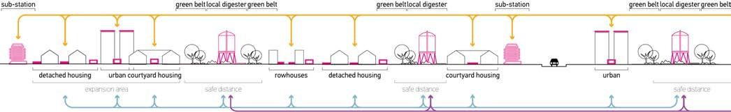
“AMA, balanced” rethinks the Amsterdam Metropolitan Area (AMA) through a circular economy framework, addressing regional inequality and promoting balanced development. The proposal emphasizes renewable energy as a transformative opportunity to replace linear economies with sustainable, decentralized systems. The strategy comprises two key components: a bio-process framework and a smart grid. The bio-process framework manages material flows, converting biomass from urban agriculture and household bio-waste into electricity. Operating across scales from region to neighborhood, this system includes localized digesters and biogas-to-energy plants, fostering energy autonomy. The smart grid connects households, neighborhoods, and energy systems, enabling decentralized electricity distribution. Multifunctional storage hubs serve as activators, linking material flows with energy generation and distribution. These hubs are tailored for four neighborhood typologies: courtyard, row house, detached house, and high-rise house. Starting at the neighborhood scale, the integrated system decentralizes energy production while engaging citizens directly. By combining bio-processes with a smart grid, the proposal aims to transform AMA into a model of efficient, sustainable urban development, balancing opportunities across the region and promoting energy independence.
Research and Design Studio Spatial Strategies for the Global Metropolis
Academic Programme
Master of Science (MSc) in Architecture, Urbanism and Building Sciences, Mastertrack: Urbanism
Institution
Department of Urbanism, Faculty of Architecture and the Built Environment, Delft University of Technology (TUDelft), NL
Academic Year
2017-2018 Spring Semester Q3
Tutors
dr. Luisa Calabrese, dr. Diego Sepulveda Carmona
Type
Regional Design, Strategic Spatial Planning, Tactical Spatial Design
Collaborators
Fransisco Monsalve, Lieke Marijnessen, Simin Chen
Personal Role and Contribution conceptualization, fieldwork, research, analysis, regional design, material flows design, spatial design, visualization, presentation (only material developed by the author, or with the contribution of the author, are shown)
Location
Amsterdam Metropolitan Area (AMA), the Netherlands

Spatialization and Material Flows
The project is based on two key premises: organizing material flows between urban centers and the periphery, and designing a network for a new electricity production and distribution system. It connects urbanized landscapes on the periphery of the AMA through transformation components that regulate material and electricity flows. Each urban typology is treated as a distinct case study to apply a collective framework for electricity production, distribution, and consumption.
Urban environment typo-morphologies


district scale (urban/peri-urban/extra-urban)


and Lieke Marijnessen)
Figure 11.3. Schematic sections for the organization of material and electricity flows within the periphery of the AMA.
Multimedia HUB
a procedural design approach for a mat organization of the relationship between collective and individual productive-residential urban programmes, the case of media production
This studio project explores the spatio-temporal relationship between residential and work environments, focusing on the creative economy, specifically multimedia production. The study is grounded in a manifesto addressing home-work relationships and their urban manifestations.
The urban block serves as both a formal and functional framework, acting as a unit for organizing urban environments. It clusters individual programmes within the urban fabric, forming constellations of hybrid residential-working spaces.
The project investigates the interplay between consumptive and productive urban functions, as well as individual and collective habitation. It emphasizes organizing labour spatially and temporally, integrating social time and individual schedules. This framework establishes a utopian work environment characterized by collaboration, solitary work, and a connection to the public sphere through open clusters, leading to the concept of the **MultimediaHUB**.
The design employs a procedural mat approach, envisioning the MultimediaHUB as a single living organism. This modular, autonomous unit integrates form and function, balancing self-regulation and connection to the broader urban context. Spatial organization emphasizes areas of concentration, clustering uses to enhance centrality and interaction. The project’s design creates a cohesive environment where hybrid uses and modular architecture facilitate a dynamic relationship between personal, collective, and public spaces.
Course
Architectural Design Studio VII
Academic Programme Integrated Master’s/Diploma degree in Architecture/Architectural Engineering (MArch, Dipl. Arch. Eng)
Institution
Department of Architecture, Faculty of Engineering, University of Thessaly, GR
Academic Year 2013-2014 Autumn Semester
Supervisor
Zisis Kotionis (professor), Vasso Trova (professor), Costis Paniyiris (professor)
Type
Procedural Architectural Design
Collaborators
Aikaterini Dimoula, Aikaterini Solomou, Eleni Rigaki
Personal Role and Contribution conceptualization, fieldwork, research, analysis, methodology development, design, visualization, presentation
(only material developed by the author, or with the contribution of the author, are shown)
Location Athens, Greece

Design Process (massing/volumetry)


volumetric perforations

2.1 extension of adjacent streets on ground level

2.2 top-to-bottom volume subtractions

2.5 identical subtractions to those of lower level for the establishment of open space (5th level)


2.3 subtraction of elements per unit (ground, 2nd 4th levels)

2.6 establishment of further public open-air and semi-open-air space and corresponding subtractions (1st 3rd and 5th levels)


2.4 further subtractions of elements relative to and expanding upon the previous for better lighting conditions (1st and 3rd levels)

2.7 expansion of public use areas (ground level)


Figure 12.1. Photorealistic axonometric representation of the spatial design proposal.
3. volumetric openings
Figure 12.2. Volumetric design process (massing).
Design Brief
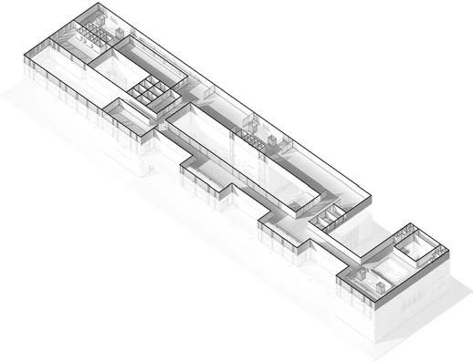
The project creates a multi-level mat building where urban, individual, and collective programmes integrate around public space. Form and function follow procedural rules of assembly, organizing built programmes through horizontal proximities and vertical circulation. This approach dissolves the verticality of individual property regimes into more collectively shared spatial and temporal uses. The result is a constellation of built and unbuilt volumes interconnected by vertical permeations and horizontal routes, fostering a cohesive and permeable environment.

The design integrates four primary programmes—residential space, individual studios, collaborative studios, and public studios—arranged by decreasing privacy. Circulation and public space emerge through procedural rules that standardize programmatic relationships, interpret them as spatial units, and apply them across the site. Volumetric subtractions address climatic and programmatic needs. Uses are distributed horizontally and vertically, resulting in a composition of spatial relationships on the horizontal plane and volumetric clusters in the vertical dimension. The design balances privacy, functionality, and environmental considerations.


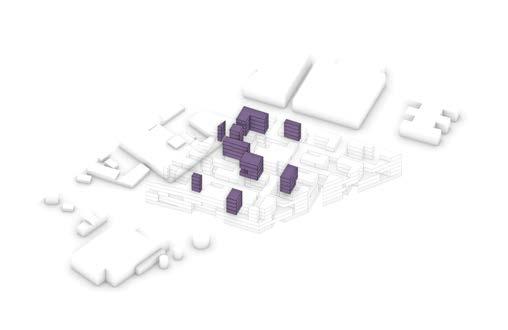

Figure 12.4. Development of spatial programmes, their programmatic relations, the standardized spatial unit and
Distribution (massing /volumetry)
Figure 12.6. Schematic sections of the vertical distribution of spatial programmes.


Structural Configuration
The structural configuration uses a rational grid allowing flexible volume adjustments while maintaining integrity, with levels designed as either single or multilayered.
Load-bearing Structure


Figure 12.11. Structural grid (credits: Sarantis Georgiou and Aikaterini Dimoula).
Figure 12.12. Floor levels typology (credits: Sarantis Georgiou and Aikaterini Dimoula).
Figure
Programme and Form
Redesign of the Helsinki Central Library (competition brief)
The studio focuses on designing a multi-programmatic building that integrates seamlessly with its urban context while maintaining autonomy. Inspired by the 2012 Architectural Competition for the Helsinki Central Library, the proposal uses the “atrium” concept, arranging volumes around open spaces to create a dynamic built composition.The building’s design emphasizes interaction with its surroundings. Open facades face public spaces, while closed facades address adjacent structures, creating a massing that responds to the urban environment. This approach extends to the floor plan, where the ground level is open to enhance public engagement. As the structure rises, the atrium concept takes shape, with spaces organized around a circular horizontal and vertical flow. Circulation within the building reflects this circular motion, connecting various spaces and services around open areas. Public, open-air, and semi-open-air spaces occupy a significant portion of the site, reinforcing the building’s integration with its surroundings and its urban character. Ultimately, the design creates a balance between openness and enclosure, vertical and horizontal dimensions, establishing a vibrant urban organism that fosters public interaction while retaining a sense of autonomy.
University of Thessaly, GR
Academic Year 2013-2014 Autumn Semester
Tutor Iordanis Stylidis, associate Professor Type Architectural Design


Magazine for Urbanism and Landscape Architecture (ISSN 1387-3679)
Volume 29: Thematic Agenda
Emerging phenomena challenge traditional spatial categories, necessitating a shift in our understanding of spatiality. Qualities such as the unfixed, intertwined, multi-scalarity, and the interplay of finite and infinite demand new conceptual tools. This issue reconsiders the concept of the ‘object’ as a ‘field’—a dynamic unity created by actions and actors. This reframing sees space as abstract and absolute, shaped and given meaning through actions, activities, and practices that transform it into a ‘territory.’ Questions arise: Are these territories real or imaginary, small or vast? Do they conform to pre-existing borders, or reflect human activities and natural forces? These inquiries highlight processes shaping our understanding and intervention in space, encapsulated in the term “territor(e)alities.” We explore spatiality by examining the processes and networks that create places. Territories are viewed as conceptual constructs emerging from agglomerated practices or a dominant action, becoming tangible and real. By zooming in and out, isolating and unifying, the issue investigates the meaning and content of Urbanism and Landscape Architecture in the 21st century and beyond, emphasizing the dynamic interplay of human and natural forces in constructing our spatial realities.
Platform for Urbanism and Landscape Architecture, Department of Urbanism, Faculty of Architecture and the Built Environment, Delft University of Technology (TUDelft), NL
Editor-in-Chief
Personal Role and Contribution as Editor-in-Chief: moderating the content of the magazine (thematic agenda and topic development, calls for submission management, article reviewing), editing, publishing
Issue Repository https://issuu.com/atlantismagazine
Figure 14.1. Excerpt pages from the Thematic Agenda of Volume 29 (Issues 29.1, 29.2, 29.3, 29.4) of “Atlantis Magazine for Urbanism and Landscape Architecture” (source: https://issuu.com/sarantisgeorgiou/ docs/territorealities_thematicagenda_atlantis_20182019).

as Editor as Editor-in-Chief


as Editor-in-Chief

“Constructed Geographies”
“to territorialize is to exert a set of acts of (relative) violence upon a portion of space, making it perform according to specific cultural demands; in other words, to ‘construct’

“Contested Domains”
“to territorialize is to (attempt to) ascertain sovereignty over the space required by a system of cultural (re-)production’

“Challenged Realms”
“to territorialize is to respond to forces originating from exteriority and alterity, seeking to undermine autonomy and to substitute, replace and/or displace an existing order’

“Emerging Appropriations”
“to territorialize is to transgress the (perceived as) fixed in light of new possibilities, hypotheses, demands and desires’
Volume 28: “Action - Reaction” Volume 29: “territo[e]alities””
Figure 14.2. Represenation
Figure 14.3. Representation of the covers of the issues of Volume 29 (Issue 29.1, Issue 29.2, Issue 29.3, and Issue 29.4) (source: https://issuu.com/atlantismagazine).
Staging Rehearsal
Scenographic design for a production of Bertolt Brecht’s “The Good Person of Szechwan”
This studio project focuses on developing a scenic design for Bertolt Brecht’s *“The Good Person of Szechuan”*, grounded in Brecht’s theatrical principles. Two key aspects of Brecht’s work guide the proposal: the use of the ‘intermezzo’ as a narrative structure and the scenographic design as a tool to remind audiences that the play is not a representation of reality. These concepts are integrated through the notion of ‘rehearsal,’ where both ideas converge.
The stage is divided into three distinct areas: the front connects actors and audience directly, the middle hosts the primary action of the play, and the back serves as a waiting area for actors. This spatial division allows the ‘intermezzos’ to unfold separately while exposing the audience to the actors’ off-stage presence. By making the audience aware of the actors as observers, the design underscores the fictional nature of the play and challenges the illusion of realism.
The scenic design intentionally avoids mimicking real-world settings, presenting itself instead as an obvious theatrical construct. This deliberate artificiality aligns with Brecht’s aim to ensure the audience remains critically engaged with the narrative rather than absorbed in its realism.
The result is a dynamic stage environment that emphasizes the constructed and performative nature of the play, encouraging audiences to reflect on its themes with a critical perspective.there is no resemblance to a real condition but, rather, the space itself is, indeed, nothing more than the place where the production of a theatrical play is told.

Course
Scenic Space Design
Academic Programme
Integrated Master’s Degree in Architecture/ Architectural Engineering (MArch, Dipl. Arch. Eng.)
Academic Year 2012-2013 Spring Semester
Institution
Department of Architecture, Faculty of Engineering, University of Thessaly, GR
Tutor
Eva Manidaki,
teacher
Type Scenographic Design
Narratives of the Un-Covered
This research explores a novel approach to the open spaces within urban building blocks, framing them as “literary constructions.” By mapping existing features or attributing new ones, it aligns these spaces with selected literary concepts, drawing on Rob Krier’s urban space theory, Marc Augé’s anthropology, and Mikhail Bakhtin’s literary theory.
According to Krier, open spaces in urban blocks represent a unique “in-between” zone of collective ownership, bridging public urban spaces and private domains. This dual nature defines their essence as thresholds or transitional zones. These spaces are conceptualized similarly to urban squares, capable of hosting community-oriented activities typical of squares and serving as vital spaces for neighborhood interaction.
The framework incorporates an abstract “tower” typology intersecting the surrounding buildings, symbolizing the integration of collective and individual spatial narratives. By emphasizing the threshold quality and promoting activities that foster communal engagement, the approach reimagines open spaces as dynamic intersections of urban life and literary inspiration, contributing to neighborhood identity and functionality.
Tutors
Filippos Oraiopoulos, emeritus professor
Type
Architectural/Urban Theory
Figure 16. The cover page and the contents page (containing the chapters: “the mythos/the plot”, “the hero” and “the inversion”) referring to the characteristics of the un-covered space of urban blocks as a polyphonic novel (source: http://www.arch.uth.gr/el/ projectpopup/index/1183

Publications & Contributions
Souverijns, N., Lauwaet, D., Capela Lourenço, T., Gomes Marques, I., Saeed, F., Saleh Khan, M., Irfan, K., Georgiou, S., Davidel, R., De Paep, M., Hermand, S., Kropf, C. M., Yeung, K. L., Lejeune, Q., Menke, I., and Schleussner, C. F. (2024). Combating heat stress through urban planning: integrated case studies for Lisbon and Islamabad [Manuscript submitted for publication]. Landscape and Urban Planning
Georgiou, S. (in press). Cultivated Ecologies: Operational Landscapes of Material Production as Flood-related Risk Infrastructure. In Kuzniecow Bacchin, T., LaFleur, F. & Recubenis Sanchis, I. (Eds.), NEXT: Next generation of infrastructure design under the condition of extremes TU Delft/Delft Deltas, Infrastructures & Mobility Initiative (DIMI). Delft, NL.
Davidel, R., Doneddu, M., De Paep, M., Georgiou, S., Hermand, S., Martyr-Koller, R., Capela Lourenco, T., Gomes Marques, I., Gonzales Lindberg, H., Kropf, C., Irfan, K., Saleh Khan, M., & Souverijns, N. (2024). Co-developed iconic overshoot adaptation scenario narratives and high-resolution maps (No. D4.3). https://doi.org/10.5281/zenodo.14528195 Gonzales Lindberg, H., Gjertsen, A., Capela Lourenço, T., Gomes Marques, I., Saleh Khan, M., Saeed, F., Irfan, K., Thomas, A., MartyrKoller, R., Georgiou, S., De Paep, M., Davidel, R., Hermand, S., Souverijns, N., & Kropf, C. (2023). D4.2 Four Overshoot Proofing reports for Iconic Regions and Cities Zenodo. https://doi.org/10.5281/zenodo.13627542
Lejeune, Q., Souverijns, N., Georgiou, S., Schwind, N., Ali, S., Capela Lourenço, T., Irfan, K., Lauwaet, D., Gomes Marques, I., Gonzales Lindberg, H., Menke, I., Nath, S., Pfleiderer, P., Pires Costa, H., Saeed, F., Saleh Khan, M., Schmidt, S., Theokritoff, E., Yesil, B., and Schleussner, C.-F.: A public database of future heat stress in 140 cities to examine the potential for heat reduction via climatesmart urban development, EGU General Assembly 2024, Vienna, Austria, 14–19 Apr 2024, EGU24-15412, https://doi.org/10.5194/ egusphere-egu24-15412
Loomans, P., Roussel, J., Bourdet, G., Vanbossuyt, F., Huylenbroeck, C., De Muynck, A., Van Raemdonck, M., De Muynck, P., Guang, T., Wijns, K., Oosters, N., Georgiou, S., Fernandez, M., Allaouzi, Y., Leyseele, J., Seminck, L., Geudens, G., Roothaer, P., Heath, A., Vermeire, P., Deruyver, M. (2022). Manifest voor het Project A8-Halle. De Werkvennootschap
Nilsson, A. E., Kassahun Temesgen, A., Capela Lourenço, T., Costa, H. P., Saleh Khan, M., Saeed, F., Thomas, A., Georgiou, S. De Paep, M., Hermand, S., Davidel, R., and Doneddu, M. (2022). D4.1 Four review reports on key overshoot adaptation challenges in Iconic Regions and Cities. Zenodo. https://doi.org/10.5281/zenodo.14526173
Georgiou, S. (2022). The City as a Resilient Ecosystem. In A. Borneke & F. Gonzalez (Eds.) The Circular City: Accelerate the TransitionLetting Cities Guide the Way (pp. 10-15). Urban Insight by Sweco
Georgiou, S. (2022). Spatial form and water-sensitivity re-discovering ground/surface water systems as structuring elements of the urban condition . Stathprints. https://doi.org/10.17868/strath.00080543
Georgiou, S. (2022). Cultivated Ecologies: Operational Landscapes of Material Production as Flood-related Risk Infrastructure. Atlantis Magazine for Urbanism and Landscape Architecture
Georgiou, S. (2020). Cultivated Ecologies: Operational Landscapes of Material Production as Flood-related Risk Infrastructure. In Couling, N, & Hein, C. (Eds), The Urbanisation of the Sea: from Concepts and Analysis to Design (pp. 244-246, 265). nai010 publishers. Rotterdam, NL.
Georgiou, S. (2019). Cultivated Ecologies: Operational Landscapes of Material Production as Flood-related Risk Infrastructure [Master’s thesis, Delft University of Technology]. TUDelft repositories. educational repository. http://resolver.tudelft.nl/uuid:d8569c6f-c21a4cd2-87ff-84a81797851e
Georgiou, S. (2018). Transcalar and Stratified: gradients of composite landscapes and networks. Atlantis Magazine for Urbanism and Landscape Architecture, 29(1) 10-13.
Flores, E. P., & Georgiou, S. (2018). Infrastructural Strata: Exploring the Past and Present of Mexico City. Atlantis Magazine for Urbanism and Landscape Architecture, 28(4) 15-18.
Farmazon, A., Heeringa, I., & Georgiou, S. (2018). Conditional Territories. Atlantis | Magazine for Urbanism and Landscape Architecture, 28(3), 31-34.
Conferences & Symposia
Georgiou, S. (2024, June 09 - 12). Contrasting Adaptation Measures: Developing Plans for Urban Greening Against Heat in the Interface between Climate Modelling and Stakeholder Participation [Oral presentation]. What Works Climate Solutions Summit, TUBerlin, Berlin, Germany
Georgiou, S. (2022, June 27 - 29). Performative Land Cover: the water-sensitive performance of vegetation as the foundation of urbanization patterns [Oral presentation]. Urban Forests, Forest Urbanisms & Global Warming: Developing Greener, Cooler and more Resilient Cities Conference, Leuven/Brussels, Belgium
Georgiou, S. (2022, February 22 - 24). Cultivated Landscape Ecologies: Water-Sensitive Patterns of Productive Urban Nature [Oral presentation]. Ecocity World Summit 2022, Rotterdam, NL
Georgiou, S. (2022, February 22 - 24). Water-sensitive Land Cover Patterns: a parametric multi-variate approach for a systemic urban landscape infrastructure design [Poster presentation]. Ecocity World Summit 2022, Rotterdam, NL
Georgiou, S. (2021, September 8 - 10). Planning Through Design: Organization of Nature According to the Spatialization of the Quantification of Its Performance, the Case for Water-Sensitive Vegetative Land Cover [Oral presentation]. The UK-Ireland Planning Research Conference “Re-imagining the Planning Project”. School of Architecture, Planning and Landscape, Newcastle University Georgiou, S. (2021, June 29 - July 3). Spatial Form and Water-sensitivity: re-discovering ground/surface water systems as structuring elements of the urban condition [Poster presentation]. International Seminar on Urban Form “Urban Form and the Sustainable Prosperous City”, Glasgow, UK
Presentations, Lectures & Exhibitions
Georgiou, S. (2023, June 29). Landscape Patterns and Ecological Processes: Notes on a Domestication of Nature Faculty of Architecture and Civil Engineering, University of Wuppertal, DE
Georgiou, S. (2023, April 27). Circular Economy: Spatial Concomitants and Design Systems [Online presentation]. Department of Architecture, Faculty of Engineering, University of Thessaly
Georgiou, S. (2022, June 22). Withstanding, Coping, Embedding: Introduction to Resilient Spatial Planning, Design and Engineering [Guest lecture]. Chair of Urban Structure and Transport Planning, TUM School of Engineering and Design, Technical University Munich, DE
Georgiou, S. (2021, May 12). Cultivated Ecologies: Productive Constructed Nature as Water-sensitive Landscape Infrastructure [Presentation and panel discussion]. Barcelona Architecture Week. (2021, May 6 – 16). Barcelona Pavilion: Barcelona, SP.
Georgiou, S., Zonghao, W. & de Bode, M. (2019). Transformation towards Synergy in the Construction of Urban Systems: Merwevierhavens [Poster design proposal]. Port City Futures Conference. BK Expo. (2018, December 17–19). Faculty of Architecture and the Built Environment, TUDelft: Delft, NL.
Georgiou, S. (2018). Productive Ecologies [Mixed technique]. Territory as Project: Parliament of the North Sea, 2nd one-day symposium and exhibition on extreme ecologies, urbanization, and forms of life. Berlagezaal 1&2. (2018, December 7), Faculty of Architecture and the Built Environment, TUDelft, Delft, NL.
Georgiou, S., Zonghao, W. & de Bode, M. (2018). Transformation towards Synergy in the Construction of Urban Systems: Merwevierhavens [Design proposal]. The ENGINE ROOM of the city: utilizing relations between subsurface and surface International Architecture Biennale Rotterdam (IABR). (2018, June 14). Rotterdam, NL.
Distinctions
December 2021
Finalist (Europan 16 Competition Entry Tragel in Transition: Integrated framework for a Circular District) Europan Belgium, Europan Europe
12 th May 2021
Selection & invitation for participation at the Barcelona Architecture Week (presentation and panel discussion) Fundació Mies van der Rohe & Future Architecture Platform: “Architecture for the Future: Landscapes of Care”
© 2025 Sarantis Georgiou