3 minute read
FMA Board Agency Report
FMA BOARD AGENCY REPORT NOAA/NWS
Alan Haynes, Hydrologist in Charge, California Nevada River Forecast Center December 1st, 2021
New Interactive Short Range Ensemble Graphic
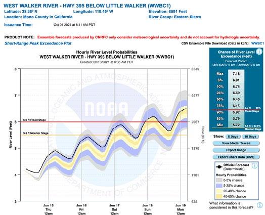
The CNRFC has gone live with a new interactive short range streamflow graphic on their webpage for all Hydrologic Ensemble Forecast Service (HEFS) locations. This new graphic replaces old static graphics and includes much more capability. A brief YouTube video is available explaining how it works: https://youtu.be/D0lgT5ZP9T8. A contrived image representing the look and feel of these new graphics for a forecast point on the West Walker River is presented below in Fig. 1 for illustration purposes. Watch the video linked above for more information on how to interpret these plots.
Figure 1 – Fictional 5-day probabilistic plot of the hydrograph for the West Walker River – Highway 395 Below Little Walker. Figure 2 – List of forecast points added this year including location ID and a brief description.
New Forecast Points Added to CNRFC Interactive Map
The CNRFC added a few forecast locations this year, accessible as “Other Points” from the CNRFC webpage. These forecast locations and their associated IDs are listed in tabular form in Figure 2 below.
Location ID Description SPYC1 Pilot Creek - upstream of Stumpy Meadows
TRNC1 Trinity River - abv NF Trinity River nr Helena
RROC1 Russian River below Guernville (GUEC1) down to Hwy 1 bridge
HODC1 San Dieguito River - Hodges Dam
BTJC1 Big Tujunga Cr – Big Tujunga Reservoir
BRTC1 Pine Valley and Cottonwood Cr Conflu. - Barrett Lake
SUDC1 Santa Ysabel Cr - Sutherland Reservoir
HANC1 Big Tujunga Cr – Hansen Dam
Yuba-Feather
This is the newest FIRO project, and a work plan is in place to help develop a Preliminary Viability Assessment. There are eight work teams tackling this FIRO project: 1) Water Resources Engineering Team, 2) Verification Team, 3) Observations Team, 4) Meteorology Team, 5) Hydrology Team, 6) Communications Team, 7) Economics Benefit Team, and 8) Decision Support Team. Efforts are also underway to update the Water Control Manuals (WCMs) for Oroville and New Bullards Bar reservoirs, scheduled to complete in FY2024. The Sacramento District of the USACE will receive $22.5 million to update various WCMs.
17
Update on Forecast Informed Reservoir Operations (FIRO)
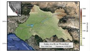
There are three formal Forecast Informed Reservoir Operations (FIRO) projects that the California Nevada River Forecast Center is participating in, Lake Mendocino, Prado Dam, and the Yuba-Feather basins. Figures 3-5 identifies these three areas. These FIRO projects represent deep collaboration between various agencies, including the US Army Corps of Engineers, California Department of Water Resources, National Oceanic and Atmospheric Administration, UC San Diego Scripps Institution of Oceanography, Sonoma Water Agency, Orange County Public Works, Yuba Water Agency, US Bureau of Reclamation, and the US Fish and Wildlife Service.
Lake Mendocino
A Preliminary Viability Assessment (PVA) was released in 2017 regarding Forecast Informed Reservoir Operations at Lake Mendocino. A Final Viability Assessment (FVA) was published in December of 2020. An economic assessment, funded in part by the U.S. Bureau of Reclamation, was completed to quantify the benefits of FIRO for dam operations, water supply, fisheries, recreation, and hydropower. It found that FIRO will lead to positive benefits in all these areas except hydropower, resulting in total estimated annual benefits of $9.4 million. In early 2020, Sonoma Water Agency saved 11,000 acre-feet of water in Lake Mendocino (20% of its water capacity at the time) by implementing a deviation request that allowed the U.S. Army Corps of Engineers to use decision support tools developed as part of FIRO. Nevertheless, a dry year resulted in nearly record low storage levels going into the fall, with storage at Lake Mendocino registering near 13,000 acre-feet in late October, just before heavy rain arrived associated with an atmospheric river. The record low storage at the lake was 12,081 acre-feet in November 1977. As of November 28th, 2021, storage had increased to 20,732 acre-feet, still nearly 50,000 acre ft below the flood control pool. The Steering Committee for the Lake Mendocino FIRO project is currently focused on supporting a new Water Control Manual that will take advantage of meteorological and hydrologic forecasts routed through a Decision Support Service (DSS) to help better manage water at Lake Mendocino, and on research aimed to improve weather forecasts.
Prado Dam
A Preliminary Viability Assessment for Prado Dam was published in August 2021. This FIRO project, found that 7,000 acre-feet per year of stormwater could potentially be added to groundwater recharge in Orange County. The Steering Committee is now focused on producing a Final Viability Assessment.
Fig. 3 – Map of the Russian River watershed. Fig. 5 – Map of the Yuba Feather watersheds.

Fig. 4 – Map of the Santa Ana watershed.


