5 minute read
Strong storms bring flooding, slides to WNC


BY CORY VAILLANCOURT S TAFF WRITER H eavy rains and high winds associated with strong storms last Sunday night led to plenty of headaches Monday morning, as downed limbs cut power and closed roads while swollen streams slipped their banks, flooding businesses and residences across Western North Carolina.
Per National Oceanic and Atmospheric Administration radar, during the 24-hour period ending at noon on April 13, Haywood County east of Interstate 40 picked up between 1 and 2 inches of rain, but the western half of the county reported between 2 and 4 inches. Areas south of Canton, including Cruso, reported more than 5 inches.
“Officially 8.31 inches fell [in Cruso] in a very short amount of time, maybe 6 or 7 hours,” said Greg Shuping, Haywood County’s director of emergency services. “That community took the brunt of it, and then of course the chain reaction began with Bethel, Canton and Clyde, all the way down.”
Those are the communities through which the Pigeon River and its tributaries flow; when they join together, they can produce quick and dangerous floods.
Shuping said he was aware of four specific water rescues carried out by first responders in Cruso and Clyde, although he couldn’t say how many people were extracted during each rescue. Shuping also commended members of the Cruso and Clyde
Pisgah National Forest announces closures
Camping is no longer allowed in the Pisgah National Forest following an order enacted April 13.
The order also closes certain roads and trails, and prohibits entering or using a developed recreation site. It will remain in effect through Aug. 13 or until rescinded.
Recreation opportunities remain open on the Nantahala, Uwharrie and Croatan national forests in North Carolina, but visitors are encouraged to recreate in a responsible way so as to prevent COVID-19 transmission and the necessity for further closures. Don’t visit while sick, practice CDC guidelines on hygiene and social distancing, take your trash with you when you leave, use the bathroom before arriving and avoid crowded areas and high-use times. The U.S. Forest Service will temporarily suspend access to areas that attract large crowds and don’t meet social distancing guidelines.
Trails closed as a result of the order include: • Appalachian Ranger District: Big Butt, Douglas Falls, Walker Creek, Elk Pen, Snowball, Upper Corner Rock, Little Andy, Perkins, Bear Pen, Black Mountain Crest, Green Knob, Stair Creek, Laurel Gap, Mount Mitchell, Buncombe Horse, Big Tom Gap, Roaring Fork Falls, Setrock, River Loop, Fork Ridge, Jerry Miller, Green Ridge, Hickey Fork, Whiteoak, Roundtop Ridge, Shutin Creek, Cherry Creek, Cold Springs Horse, Buckeye Ridge Horse, Max Patch Loop, Lover’s Leap, Overmountain Victory Trail from Roaring Creek to the A.T., Pump Gap Loop, Laurel River, Groundhog Creek, Mountains-to-Sea, Hemlock, Briar Bottom and Elk Falls. • Pisgah Ranger District: Ivestor Gap, Daniel Ridge Loop, Looking Glass Rock, Slick Rock Falls, Cat Gap, North Face, Art Loeb from Davidson River to Joel Branch, Art Loeb from Black Balsam Road to Camp Daniel Boone,
fire departments, who he said had been up all night.
“Got a call at 6 a.m. from Canton FD. River is out of banks and brewery is flooding. On my way to assess damage,” said Kevin Sandefur, owner of BearWaters Brewing in Canton, in a Facebook post around 10 a.m. on the morning of April 13.
Photos posted by Sandefur show the Pigeon River nearly coming up to the bottom of the brewery’s outdoor deck. By midday on April 13, floodwaters appeared to be receding in some places, but it was clear the damage had already been done; other photos posted by Sandefur show water being pumped out of the brewery’s basement.
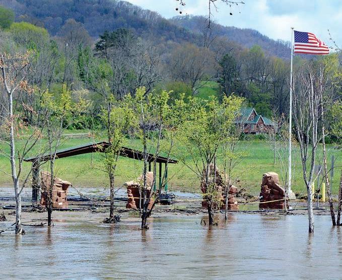
River’s Edge Park in Clyde — designed specifically to withstand periodic flooding of the Pigeon River — was still partially submerged around 11:30 a.m.
The northern sections of Jackson and Macon counties saw between 2 and 4 inches of rain, but almost the entirety of Cherokee, Clay, Graham and Swain counties logged between 3 and 4 inches. Much of eastern Tennessee saw similar totals, with some spots also recording in excess of 5 inches.
An April 13 press release issued by Macon County Emergency Services Director Warren Cabe said the storms resulted in high water, debris and at least eight slope failures, with severe impacts seen in the vicinity of Dairy Barn Loop Road and Old Murphy Road.
Because of one debris flow near Pressley Road, 16 people were evacuated; another three people in Macon County were also rescued from high-water areas. As of 1 p.m. April 13, Duke Energy was reporting just 83 Haywood County customers without power, but neighboring counties didn’t fare so well — Transylvania County still had more than 6,800 customers without power, Jackson County reported more than 5,000, Macon County had more than 2,400 and Swain County had about 700.
By the next day, all Haywood customers had power restored but about 600 in Jackson, 400 in Macon and six in Swain were still awaiting service restoration.
Moore Cove, Campground Connector, Mt. Pisgah, Graveyard Ridge, Graveyard Fields, Upper Falls, MST Access, Shining Creek, John Rock, Rainbow Falls, Sunwall, Hardtimes Gap, Deer Lake Lodge


Sunday Take-Out April 19 11 a.m.-3 p.m. Order before April 18 @5 p.m.
Southern-Style Fish & Chicken
Served Hot! Adults: Fried Catfish & Hush Puppies.........$12 Fried Chicken & Yeast Roll ...............$10 By the Bucket (12 piece): Catfish & Hush Puppies......................$24 Chicken & Yeast Rolls..........................$20 Cookies & Sweets Available
FREE KIDS MEAL with each purchase of Adult Entrée
Visit us on Facebook laurelridgeexperience.com
To Order, Call 452-0545 x140 49 Cupp Lane Waynesville
Affairs —— OF THE —— Heart

We Are Still Here! Visit our Facebook page to shop Curbside pickup & local delivery available. Buy Local!


