4 minute read
The Trailhead


The Trailhead Trail Funding Boost, Steptoe Butte, Volunteering, & More
By Holly Weiler
WELCOME TO THE TRAILHEAD, where the first stop should be the kiosk with important information that affects recreationists in our area! This new column, replacing the long-running “Hike of the Month” column, will serve as a round-up of interesting projects and plans for trails in the Inland Northwest. Here’s what trail and recreation related news we have for this spring and early summer, along with a recommended hike!
Steptoe Butte State Park will be closed for road and parking lot repairs for up to 16 weeks this spring. The exact closure window is dependant upon weather conditions, so be sure to check the state parks website before a spring visit (Parks.state.wa.us/592/ Steptoe-Butte).
Funding for the Great American Outdoors
Act was signed into law August 2020 and will begin to address deferred maintenance needs on United States Forest Service (USFS) lands beginning this summer. Search the US Department of Agriculture website for a deeper dive into how this legislation will be enabling projects across the country. Some of the local projects slated to begin in 2021 include: → Funding for 1,500 miles of deferred maintenance on backcountry trails across both Washington and Oregon through "shared stewardship" partnerships with USFS partner organizations. → Trail maintenance on 110 miles of recreational trails within Hells Canyon
National Recreation Area and the
Eagle Cap Wilderness, along with the replacement of two 60' bridges on the
Snake River National Recreation Trail. → A combination project on South Fork
Boulder Creek Road north of Highway 20 on the Colville National Forest, including relocation of the current road and conversion of the former
roadbed to a year-round multi-use trail (snowmobile in winter; non-motorized access to Taylor Ridge Trail in summer). → Trail maintenance on 50 miles of trails near Bonners Ferry, Idaho. → A trail resurfacing project and tunnel improvements on the Route of the
Hiawatha Trail near Lookout Pass. → Trail maintenance in the Mallard-
Larkins and Upper St. Joe River areas. → Improvements to both vehicle access and trails within the Ross Creek
Ancient Cedar Grove, including a boardwalk to help protect tree roots from soil compaction while granting better accessibility for all visitors.
Spokane County Parks will be building a new trailhead for Antoine Peak Conservation Area's Etter Ranch addition over the course of the summer. The new access point will be located less than 1/4mile from Trent Ave. in the Spokane Valley. Until the new trailhead is complete, access to
RUSTLER'S GULCH // PHOTO: HOLLY WEILER this portion of Antoine Peak is only available under special permit for the trail construction crews who are busy building the new connecting trail to the existing trail system. Check the Washington Trails Association and Evergreen East Mountain Bike Alliance websites for volunteer opportunities that will grant a sneak peek!
Northeast Washington Trails has a new page devoted to ways non-motorized trail users can get involved with trail maintenance projects stretching from the Okanogan Highlands to the Idaho Panhandle. Lend a hand to one of several nonprofits offering volunteer opportunities across northeast Washington, or share a conditions report about a trail issue you discovered while exploring an area. Learn more at Newashingtontrails.com/volunteer. //
Holly Weiler is a long-time contributor to Out There Outdoors. If you know where to look, you'll find her deep in a morel patch this spring.


VISIT US FOR OUR INAUGURAL SEASON LAKESIDESURF.COM
SURF THE WORLD’S LARGEST
STATIONARY WAVE
CHELAN, WA
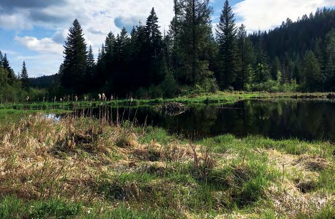
HIKE OF THE MONTH
RUSTLER'S GULCH, LITTLE SPOKANE RIVER AREA
MOST WIDELY KNOWN as Rustler's Gulch, this lovely spring hike is a portion of the West Branch Little Spokane River Wildlife Area. The best access point is from the Holly Road Trailhead west of Highway 2, which allows for a lollipop loop with a mix of double- and single-track trails. Begin on a double-track section that drops down to the wetlands. At the one-mile mark watch for an unmarked left-hand junction onto singletrack heading north, noting the dilapidated barn across the wetland to the east marking the return route. The trail winds through the forest along the edge of the wetlands for the next two miles before intersecting an alternate access point and additional trailhead at Horseshoe Lake Road.
Turn right, rejoining a double-track trail section as it heads southeast around the wetland, then bends south. This section is parallel to the hike up, but with increased views of the wetlands along the way. At the 5.5 mile mark the trail returns to the drooping barn, most safely viewed at a distance. Return to the same double-track trail as the start and climb a final mile through the lovely shaded forest to return to the parking area. Total distance is 6.5 miles with 850' elevation gain for a moderately difficult hike. Discover Pass required.


