4 minute read
Prospect Lefferts Gardens Lynch Map

from Issue 1: The Walking City
by SONDER

Prospect Lefferts Gardens Lynch Map
Venus Dulani
Advertisement
*Mental teleportation to a NYC neighbourhood. The map is not the territory*

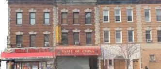
Nowadays, Google maps can give you a pretty accurate description of any area in the world, but when you live in a city, in a particular neighbourhood, on a specific street, you probably have a very different perception of what the area is like than what Google maps tells you it’s like. I live in a vibrant Caribbean neighbourhood in Brooklyn, and unfortunately like the rest of the borough, it is rapidly gentrifying. What Google maps probably does not know about my neighbourhood though, is that opposite my apartment building, there is a church, and every night in front of that church you can find cheerful middle-aged men sitting on lawn chairs, talking and playing Caribbean music on full blast. Google also probably doesn’t know that there is this particular corner with a fire hydrant, that everyone uses to flood the streets with cold water when the weather is just way too hot. At a nearby corner, you will find a daily line for fresh coconuts in front of a mini fruit stall. While on most days a site reserved for buses and cars, my street is also regularly transformed into a space for cultural parades or state senator events.
It’s generally very difficult for maps to capture the essence and daily experience of any neighbourhood. The Lynch map, introduced by urban theorist Kevin – oh you guessed it –Lynch, is in some ways closer to depicting everyday realities. His book, The Image of the City, published in 1960, is the outcome of a five-year study of Boston, Jersey City, and Los Angeles on how observers take in information of the city, and use it to make mental maps. Lynch’s conclusion was that people formed mental maps of their surroundings consisting of five basic elements: paths, edges, districts, nodes and landmarks. After nearly six months of walking around, the map above, is a Lynch map of what I think mytiny grid-like neighbourhood, Prospect Lefferts Garden, looks like. Below are some key observations based on the five elements:
Paths channel along where the observer travels. They can be streets, walkaways, transit lines, canals, or railroads. As a mode for transport, they usually set the backdrop for people’s mental maps. For the mental image of my neighbourhood, it consisted not just of the streets I use most often, but also the adjacent streets that I notice when walking.
Edges are real or perceived boundaries that distinguish one area from another. They are usually elements that break continuity and as a result are not considered as paths by the observer. These can be walls, buildings, rivers, overpasses etc. My neighbourhood has the pleasure of being bound by Prospect Park – the superior Central Park, and a hospital on the other side.
Districts are medium-to-large sections of a neighbourhood/city, considered to have a twodimensional aspect to them, which the observer mentally enters “inside of” and which are recognizable of having some common identifying character. This is truly the most interesting and surprising aspect of my area – it is genuinely mind-boggling. Walking from the east end of the neighbourhood, to the west end towards Prospect Park, you can literally identify class and race differences, street by street, leading me to decide that my neighbourhood consists of four parallel
districts. Starting from the east, you are surrounded by heavily Caribbean, relatively cheap and dense apartments, but by the time you get to the third district, you are surrounded by visibly large and expensive houses. For someone like me, who grew up in Hong Kong, these houses look like mansions, and to be honest considering New York prices, it is probably equivalent tobuying a mansion elsewhere. The fourth district as expected, due to its proximity to the park and an essential subway station, returns to a pricey apartment-style ambience, with a much more diverse and gentrified look. It is astonishing to me that all of this distinct architecture, diversity, class can exist in barely four streets.
Nodes are strategic spots or points in a city into which an observer can enter, and which are the intensive foci to and from which they are travelling. They can be places of convergence, moments of shift or breaks where the mode of transport changes. For me, it was the three stations, large intersections, and a recently discovered historic district.
Landmarks are another type of reference point, but in this case the observer cannot enter them –they are external. They are usually rather simple physical objects, such as a building, sign, store, or mountain. Like easily pointed out in Google maps, they can be schools, churches, and libraries, but what really drew me to my landmarks were the lived experiences attached to them. The frequently misused fire hydrant, men in lawn chairs, coconut stall, aroma of Allan’s Bakery, and hourly chimes of the church next door are just some of the points that helped me in forming my mental map. Another thing to notice is that landmarks are not necessarily unchanging. Going into this unwanted winter, many of these landmarks have become merely past memories as new landmarks take their place in my mind.
My mental perception of this neighbourhood may be similar or very different from another resident or visitor’s perception. To some extent, it certainly feels unlike what Prospect Lefferts Garden’s official administrative boundaries are stated to be. What makes the Lynch map unique is its ability to incorporate an observer’s lived experiences. I highly recommend reflecting on and visualizing your own neighbourhood – the result may surprise you.