HAVEN: “A SUSTAINABLE ECO-
LOGICAL SANCTUARY FOR ALL”
AN URBAN DESIGN REPORT
Neamah El Masri Chaarani 2022-2023

Title: Prepared for:
Reference:
Status:
Date:
Prepared by:
University:
Approved by:
TA:
Haven: “A Sustainable Ecological Sanctuary for All” URDS601A: Advanced Urban and Landscape Design Studio
Urban Lab (BUL) titled “An Urban Recovery Strategy for Post-Blast Karantina.”
Draft 2022-2023
Neamah El Masri Chaarani
American University of Beirut
Prof. Howayda Al Harithy
TA: Batoul Yassine
The urban and landscape design studio tackles sites of recovery. It examines the role of urban and landscape design tools and strategies in the process of recovery using the framework of social and environmental justice. It proposes the design of a network of open spaces, within a holistic and participatory framework for post disaster recovery, as catalyst for sustainable recovery of the built environment and more specifically urban place-making for marginalized communities. It takes Karantina in Beirut as its site of recovery post the Beirut port blast of August 4, 2020.
The studio takes as its base the study conducted by the Beirut Urban Lab / BUL entitled “An Urban Recovery Strategy for Post-Blast Karantina.” The study adopts the City Development Strategy /CDS model and adapts it to the scale of the neighborhood and towards recovery. It follows the five methodological steps, from profiling, strategic diagnosis, and strategic framework to designing action plans and indicator systems. One of the proposed action plans is the design of a network of open spaces, which is taken as the focus of the studio.
*See the full study: https://beiruturbanlab.com/en/Details/889/an-urban-recovery-strategy-for-post-blast-karantina
TABLE OF CONTENT
PHASE ONE
I. Introduction and Methods
II. Case Study Profile . Documented Data Compiled
III. Key Findings and Assesment if Urban Trends
IV. Problem Statement
PHASE TWO: METHODOLOGY
A. Theoretical Underpinning
B. Objectives
C. Concept
D. Network of Open Spaces
E. Mobility Strategy
F. Program Strategy
PHASE THREE: DESIGN PROPOSAL
V. Proposed General Urban Strategy and Detailed Policy Recommendations for Urban Intervention
03
STUDIO OBJECTIVES
The studio intends to propose innovative, feasible, concrete spatial strategies for recovery in Karantina through the design and reconfiguration of public spaces in post disaster times, particularly those charged with cultural heritage and socio-spatial practices. The position of the studio is four fold:
-That urban design in complex urban contexts happens at a range of scales, from city to neighborhood and to site.
-That public space is a restructuring / a reconstructive element of the re-covered sites
-That community based socio-spatial practices and cultural heritage are necessary points of entry to post disaster recovery of identity and reconciliation of communities as it restores a sense of belonging through shared memories and cultural practices.
-That the public realm is the platform to promote socially just governance and a participatory design approach
The studio therefor interrogates the approaches to post disaster recovery and the role of urban design in shaping an “integrated social space” within the process of “cultural recovery” as an instrument for the creation of public amenity as “inclusive space of reconciliation” across the scarred cityscape that witnessed spatial and physical expressions of conflict.
Approach and Methodology
Design is approached as a process of inquiry and as an inter- and trans-disciplinary method of urban intervention. The studio therefore approaches the urban design process as discursive and grounded in scenario-based methods
that are backed up by rigorous research, analysis and interpretation and intended to propose “strategic design interventions” that recognize ecological, environmental, social, economic, cultural and political layers of the city as a whole and the neighborhood in specific. The methodology is therefore an integrated design methodology to urban design, which dissects and collapses layers of the urban public domain including the ecological, political, the social, the spatial, the economic, the infrastructural and the cultural.
The studio provides students with the skills, critical understanding and theoretical bases necessary to understand the role urban design tools and strategies in the processes of post disaster recovery, and to engage in the urban design process in a critical, reflective and ethical manner.
The studio engages students in various ways from design explorations, to debates, to case studies and to readings that offer a theoretical framework for the understanding of key issue relating to post disaster recovery, and a basis for developing a studio project located it in larger contexts of social, cultural, economic and ecological processes. It will expose students to interpretive and design methods within its interdisciplinary approach. For example, the notion of “landscape as agency” that has impacted recent discourse on design is explored in the studio as the intersection between Architecture, Landscape Architecture, Infrastructure and Landscape Urbanism.
* For a list of recommended readings, see Appendix I attached to this syllabus.
Format
04 URBAN DESIGN PROJECT 2022-2023
This course follows a studio-based format. It is designed to allow students to develop a greater understanding of design processes and methodologies as they apply them to urban design projects. The studio sessions are reinforced by presentations, pin-ups and discussions of readings. The design explorations and developments are followed up closely and guided by the professors through desk crits. Guest speakers and jurors are also invited to enrich the critical discourse and the design development of projects. Students are required to participate in the discussion of design ideas and processes in the studio through both group and individual interactions.
Community Participation
Community representatives are invited for presentations, consultations and for reviews to reinforce the community based approach and to facilitate for a more participatory process. A group of citizen scientists trained under the BUL project in Karantina as well as members of the community such as business owners, workers and students will be invited to engage and to offer their views and to share their experiences, visions and preferences.
The Project: A Network of Open Public Spaces in Karantina
The selection of a network of spaces for the strategic intervention is a critical start. The entry point is public space as a place where collective memory and communal practices from the past can work as seeds for imagining a future for the neighborhood. Besides their infrastructural values, public spaces are threads in the narrative of the city at large. They encapsulate past cultural and social
celebrations, reference trauma and destruction, and also facilitate for imagining the landscapes of the future neighborhood/city.
*For more details of the assigned project and its context, see Appendix II, which articulates action plan 13 of the BUL study.
Urban and Landscape Studio Learning Outcomes
-To gain experience in documenting, analyzing and understanding urban form and its evolution.
-To develop an understanding of the cultural, economic, ecological, social and political dynamics shaping the urban environment.
-To build skills in documenting, analyzing and interpreting the spatial characteristics of the urban form
-To acquire and apply urban/landscape design tools such as sketching, visual surveys, typo-morphological and structural analysis, mapping of spatial networks, model building, scenario development, strategic planning, and space programming.
-To acquire knowledge of key urban and landscape design principles and to critically pursue them through tools, methods and strategies of urban design intervention within a complex urban context
-To develop the ability to address issues of urban recovery through a process of design conceptualization and development.
-To develop and apply advanced skills in design research, thinking and intervention.
-To apply design research and thinking to the design of public spaces from an interdisciplinary design frame towards an environmentally and culturally sound sustainable and green design intervention.
05 URBAN DESIGN PROJECT 2022-2023
INTRODUCTION AND METHODS
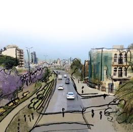
The urban and landscape design studio focuses on sites undergoing recovery, specifically exploring the role of urban and landscape design tools and strategies within the context of social and environmental justice. In this studio, we suggested the creation of a network of open spaces as a catalyst for sustainable recovery and urban place-making in marginalized communities. The studio’s case study is Karantina in Beirut, which experienced the aftermath of the Beirut port blast on August 4, 2020.
The Advanced Urban Design Studio builds upon the research conducted by the Beirut Urban Lab (BUL) titled “An Urban Recovery Strategy for Post-Blast Karantina.” The study utilizes the City Development Strategy (CDS) model, adapted to suit the neighborhood’s scale and recovery needs, which is flexible, sustainable, and incremental. It follows a five-step methodology, including profiling, strategic diagnosis, strategic framework development, designing action plans, and implementing indicator systems. The BUL trained the Karantina citizens and developed 30 action plans. Action plan 13 focuses on the design of a network of open spaces, which serves as the primary focus of the studio’s work. The studio also adopts a comprehensive approach to design, considering it as a process of inquiry and an inter- and trans-disciplinary method for urban intervention. The urban design process is viewed as discursive, relying on scenario-based methods supported by thorough research, analysis, and interpretation. The goal is to propose “strategic design interventions” that take into account the ecological, environmental, social, economic, cultural, and political aspects of both the city as a whole and open spaces specifically in the neighborhood. This integrated design methodology dissects and combines various layers of the urban public domain, including ecological, political, social, spatial, economic, infrastructural, and cultural elements.
Through design explorations, debates, case studies, and readings, the studio helped us in understanding key issues in the Karantina area. This exploration takes into account the intersection between Architecture, Landscape Architecture, Infrastructure, and Landscape Urbanism. Moreover, the studio aims to equip the research and design with the necessary skills and theoretical foundations to comprehend the role of urban design tools and strategies. Through design explorations, debates, case studies, and readings, the studio exposes students to theoretical frameworks and key issues related to post-disaster recovery. This approach helped the studio to situate our projects within broader contexts of social, cultural, economic, and ecological processes.
The Beirut Urban Lab undertook a comprehensive twoyear study, generously funded by the International Development Research Centre (IDRC), entitled “An Urban Recovery Strategy for Post-Blast Karantina.” Under the leadership of Howayda Al-Harithy, the study yielded four meticulously prepared reports. In our research endeavor, we heavily relied on the invaluable BUL data reports and maps as our primary sources of information. Furthermore, to bolster the depth and accuracy of our design proposal, we engaged in rigorous fieldwork. This included capturing photographs of the Karantina area and its focal zones, which proved instrumental in shaping and refining our design vision. In addition to fieldwork, we extensively conducted desk research, thoroughly examining relevant case studies and scholarly literature to broaden our understanding and enrich our insights. This multi-faceted methodology, comprising on-site photography, data analysis, and comprehensive desk research, formed the bedrock of our research and design approach, empowering us to develop a compelling and well-informed proposal for the transformation of Karantina.
06
URBAN DESIGN PROJECT 2022-2023
This course follows a studio-based format. It is designed to allow students to develop a greater understanding of design processes and methodologies as they apply them to urban design projects. The studio sessions are reinforced by presentations, pin-ups and discussions of readings. The design explorations and developments are followed up closely and guided by the professors through desk crits. Guest speakers and jurors are also invited to enrich the critical discourse and the design development of projects. Students are required to participate in the discussion of design ideas and processes in the studio through both group and individual interactions.
Community Participation
Community representatives are invited for presentations, consultations and for reviews to reinforce the community based approach and to facilitate for a more participatory process. A group of citizen scientists trained under the BUL project in Karantina as well as members of the community such as business owners, workers and students will be invited to engage and to offer their views and to share their experiences, visions and preferences.
The Project: A Network of Open Public Spaces in Karantina
The selection of a network of spaces for the strategic intervention is a critical start. The entry point is public space as a place where collective memory and communal practices from the past can work as seeds for imagining a future for the neighborhood. Besides their infrastructural values, public spaces are threads in the narrative of the city at large. They encapsulate past cultural and social celebrations, reference trauma and destruction, and also
facilitate for imagining the landscapes of the future neighborhood/city.
*For more details of the assigned project and its context, see Appendix II, which articulates action plan 13 of the BUL study.
Urban and Landscape Studio Learning Outcomes
-To gain experience in documenting, analyzing and understanding urban form and its evolution.
-To develop an understanding of the cultural, economic, ecological, social and political dynamics shaping the urban environment.
-To build skills in documenting, analyzing and interpreting the spatial characteristics of the urban form
-To acquire and apply urban/landscape design tools such as sketching, visual surveys, typo-morphological and structural analysis, mapping of spatial networks, model building, scenario development, strategic planning, and space programming.
-To acquire knowledge of key urban and landscape design principles and to critically pursue them through tools, methods and strategies of urban design intervention within a complex urban context
-To develop the ability to address issues of urban recovery through a process of design conceptualization and development.
-To develop and apply advanced skills in design research, thinking and intervention.
-To apply design research and thinking to the design of public spaces from an interdisciplinary design frame towards an environmentally and culturally sound sustainable and green design intervention.
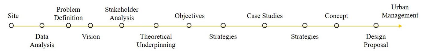
The studio is structured into six interrelated phases along 16 weeks:
1 Analysis and Vision
2 Concepts and Strategies
3 Urban Design Proposal
4 Detailed Design Proposal
5 Design Rules
6 Final Posters and Documentation
It is important to mention that we jumped into scales in the design methodology of the studio. We jumped into detailed design proposal directly after finishing the comprehensive urban proposal.
07
URBAN DESIGN PROJECT 2022-2023
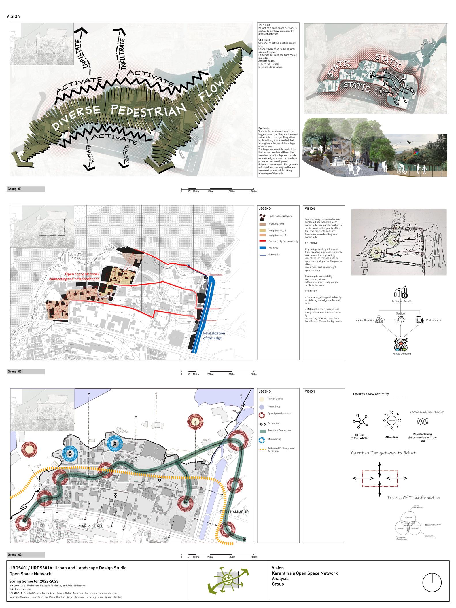
Figure 1. Studio and Design Methodology.


CASE STUDY PROFILE
Instructors: Professors Howayda Al-Harithy and Jala Makhzoumi TA: Batoul Yassine
Compiled by Students: Charbel Oueiss, Issam Raad, Joanna Daher, Mahmoud Bou Kanaan, Marwa Mansour, Neamah Chaarani, Omar Kaed Bay, Rana Khachab, Razan Elmrayed, Sara Hajj Hasan, Wiaam Haddad.
URBAN DESIGN PROJECT 2022-2023
CASE STUDY PROFILE
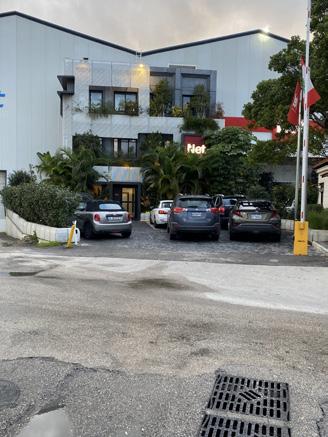
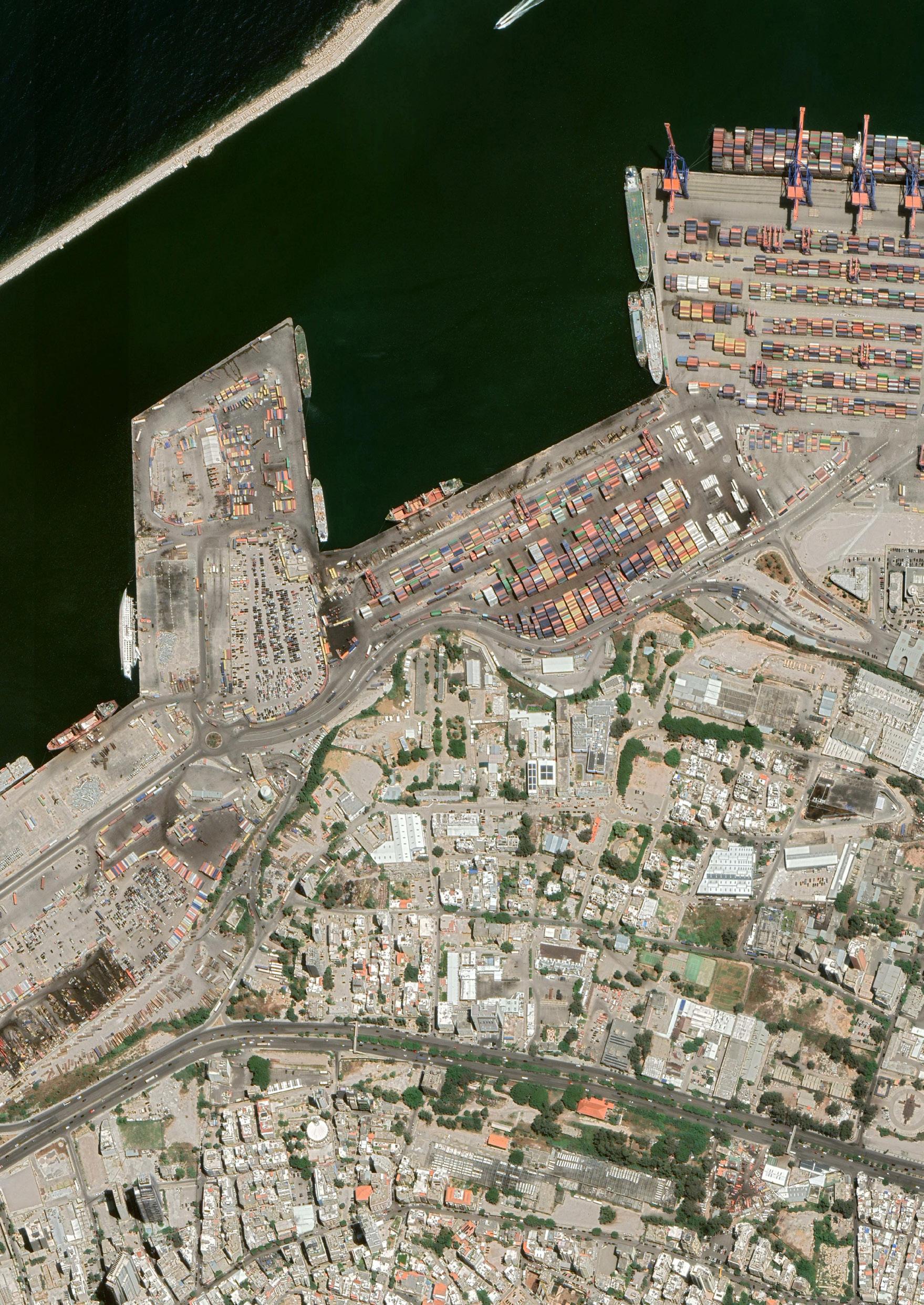
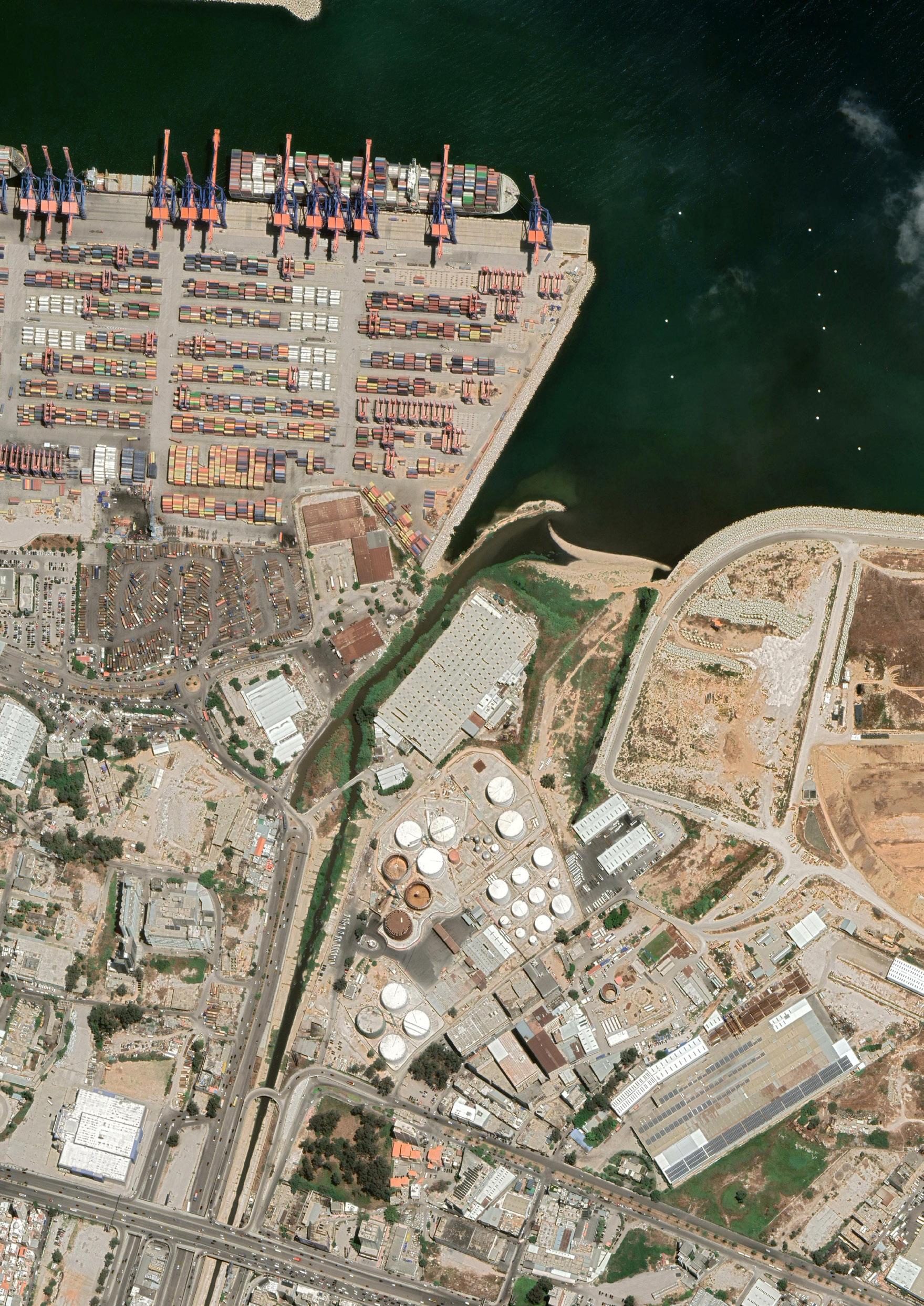
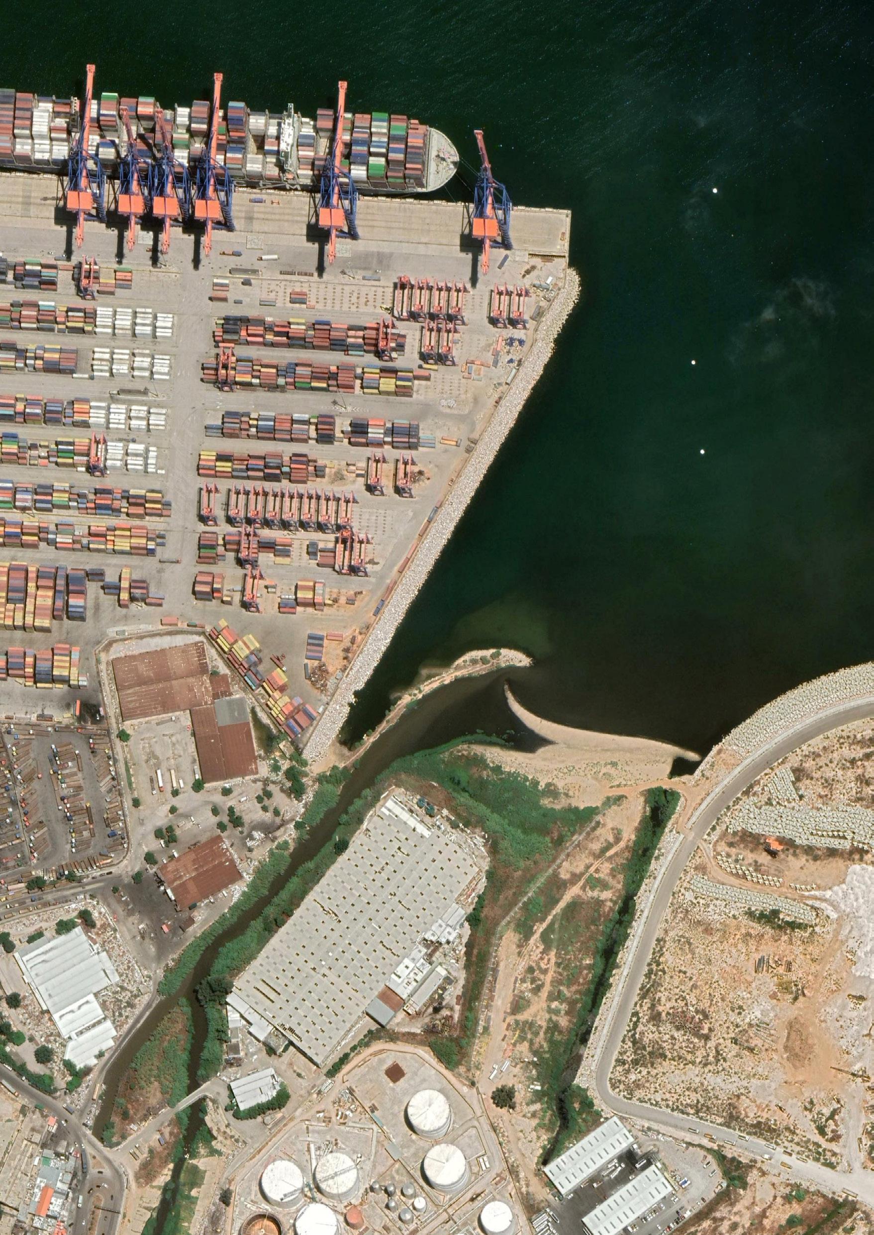
Karantina, located approximately 600 meters from the epicenter, experienced severe damage due to the port blast on August 4, 2020. The area, known for accommodating low-income residents and hosting refugees, had already faced displacement, spatial segregation, and socioeconomic marginalization. These issues were exacerbated by the blast.
BUL combined data led the study follow five steps: building a neighborhood profile, conducting a strategic diagnosis, developing an urban recovery strategy, articulating action plans, and designing an indicator system for monitoring and assessment. The reports provide in-depth analysis of five key issues: affordable housing and social inclusion, spatial, economic, and social connectivity, cultural and economic vitality, inclusive and sustainable development, and the quality of the urban environment. We as in the Advanced Design Studio, our aim was to build on this data our own vision of Karantina as a network of open and public space, used by and for all residents. Our vision focused on the open spaces in Karantina as an ecologically sensible city-scale network of diverse socio-culturally active and economically viable destinations. This will make Karantina an accessible well-connected destination, well connected internally and connecting to its surroundings by active and diverse social, economic and recreational nodes.
We formed groups and embarked on an immersive exploration of the site in Karantina. With cameras in hand, we captured photographs and spoke to some locals. Our exploration involved traversing the site on foot and by car, enabling us to gain unique perspectives from each point. Additionally, we engaged with the local community through interviews, further deepening our understanding of the area. To enhance our knowledge of the urban dynamics and activities within Karantina, we arranged a follow-up visit accompanied by citizen scientists who
provided valuable insights and explanations. This second encounter with Karantina provided us with a fresh and enlightening viewpoint, enriching our overall experience and comprehension of the area. As a result, we formulated a consolidated vision based on the gathered data, including maps and diagrams, to better understand the layers of Karantina, such as Socio-Spatial Character, Character Zones, Open Spaces, Edge Condition, and Urban Walk. Each group in the studio was responsible for developing their own interpretation of the area and producing a vision. Finally, as the design studio, we synthesized the various interpretations to create a consolidated vision for the studo, which was presented in the final panel.
The diagrams presented in the visuals were created by three different groups, each offering a unique perspective. Together, these diagrams provided an initial understanding of Karantina during the first phase of the project. Additionally, each group envisioned Karantina in distinct ways: group 1 aimed to transform it into an economic hub, group 2 envisioned Karantina as a diverse and dynamic socio-economic center, and group 3 saw Karantina moving towards a new centrality.
- Group 1: Charbel Oueiss, Marwa Mansour, Razan, Joanna;
- Group 2: Wiaam Haddad, Sara Hajj Hassan, Issam, Mahmoud;
- Group 3: Omar Kaed Bay, Neamah Chaarani, Rana Al Khachab.
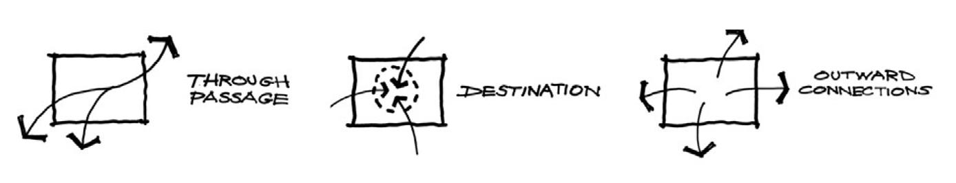
Regarding the vision for open spaces, group 1 perceived them as an ecological network and an integral part of the city’s flow. Group 2 viewed open spaces as economically active destinations, while group 3 saw them as a network interconnected with the city. Consequently, group 1, 2, and 3 respectively regarded the open space network as a through passage, a destination, and an outward connection, as elaborated in their presentations in (fig:2).
10
URBAN DESIGN PROJECT 2022-2023
Design is viewed as an investigative process and a method of urban intervention that encompasses multiple disciplines. The studio’s approach to urban design treats it as a discourse and relies on scenario-based techniques that are supported by thorough research, analysis, and interpretation. Its aim is to propose “strategic design interventions” that acknowledge the various aspects of the city as
a cohesive whole, including ecological, environmental, social, economic, cultural, and political considerations, with a particular focus on the neighborhood. Consequently, the methodology employed is an inclusive approach to urban design that dissects and merges layers of the urban public domain, encompassing ecological, political, social, spatial, economic, infrastructural, and cultural elements.
11
URBAN DESIGN PROJECT 2022-2023
Figure 2. Vision developed after phase 1.
12 URBAN DESIGN PROJECT 2022-2023
13 URBAN DESIGN PROJECT 2022-2023
14 URBAN DESIGN PROJECT 2022-2023
15 URBAN DESIGN PROJECT 2022-2023
16 URBAN DESIGN PROJECT 2022-2023
17 URBAN DESIGN PROJECT 2022-2023
KEY FINDINGS AND ASSESSMENT OF URBAN TRENDS
Socio-ecological Programs
In urban planning and design, the overlapping of socioecological activities over brownfield sites and green areas has emerged as a promising approach to implementing urban greening strategies. By integrating social and ecological elements, this approach aims to transform underutilized or vacant spaces into thriving green areas that benefit both the environment and the community. The following text expands on the concept of overlapping socioecological activities to enhance urban greening strategies:
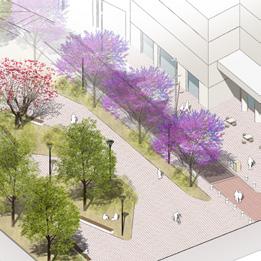
1. Establishing ecological continuity by connecting proposed densified nodes with existing nodes through the creation of a green promenade along the edges and linking them with pedestrianized roads.
2. Enhancing the pedestrian experience by implementing
rows of trees along sidewalks. Trees offer numerous benefits, such as providing shade, reducing heat, absorbing pollutants, and creating a visually appealing environment, thereby improving the overall quality of public spaces.
3. Decreasing the amount of hard surfaces and increasing the proportion of soft surfaces to reduce the runoff water coefficient.
4. Creating a green buffer zone to isolate and mitigate the negative impact of the industrial areas in Karantina.
5. Promoting social practices within the open space network by linking proposed densified nodes with existing nodes to achieve ecological continuity. This can be accomplished by developing a green promenade along the edges and establishing pedestrianized roads that encourage social interactions within the network.

18
URBAN DESIGN PROJECT 2022-2023
PROBLEM STATEMENT
Based on the data analysis and urban trends assessment discussed in the following sections, it becomes crucial to identify and focus on a research problem that aligns with specific planning and design values and objectives. The findings presented shed light on various problems, including open spaces, edge conditions, character zones, and socio-spatial practices in the area of study.
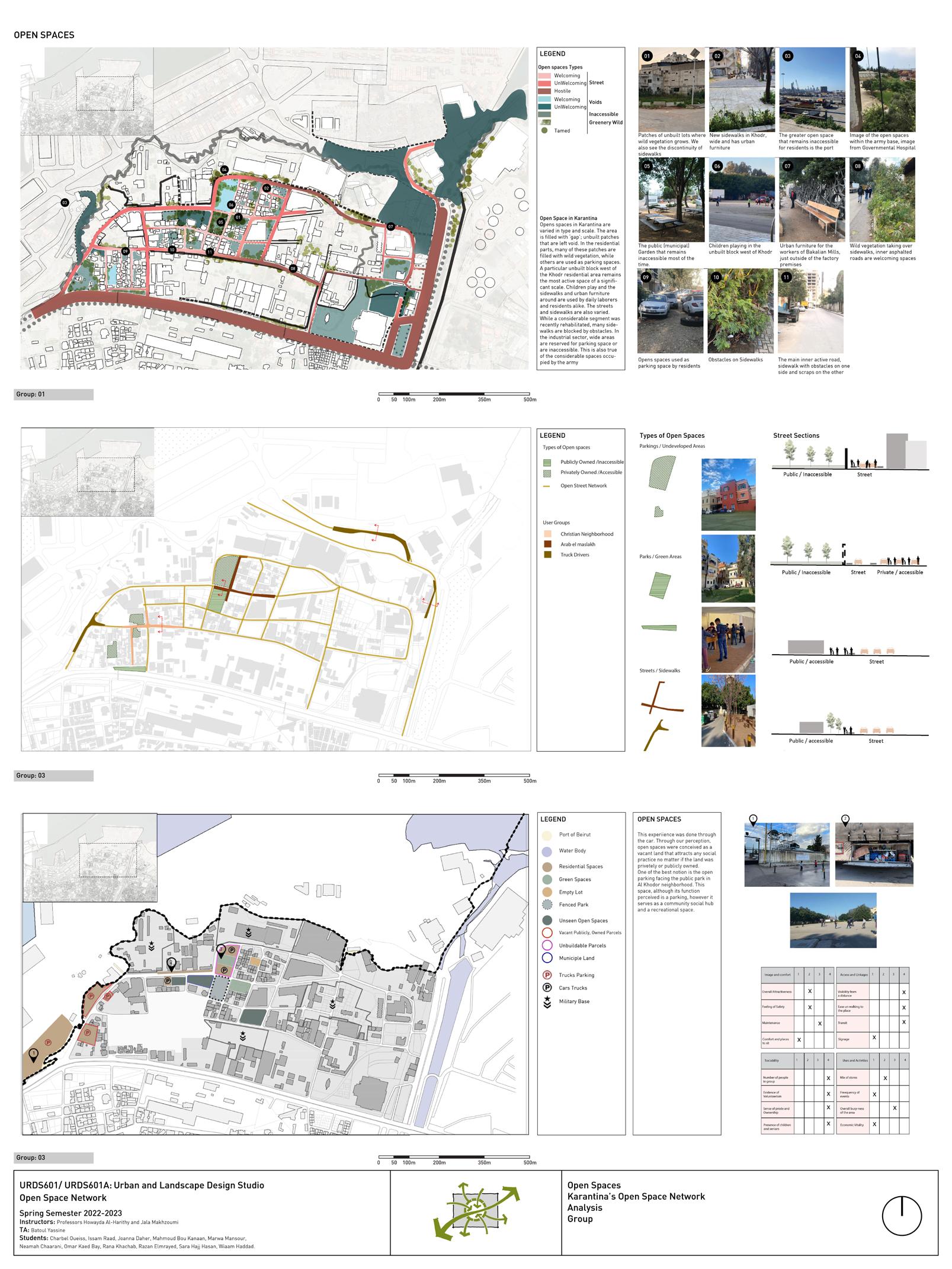
1) Open Spaces (fig.5):
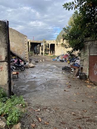
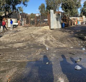
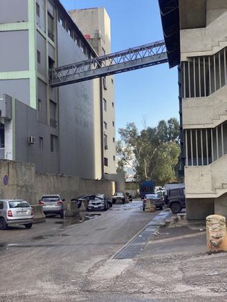
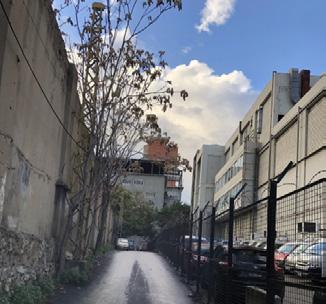
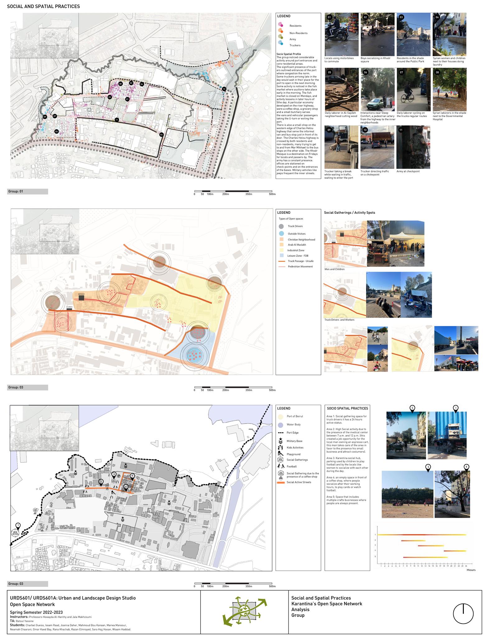
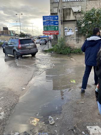
My team developed two different approaches to open spaces. We made two trips to Karantina to gather information. During the first trip, we explored the area by car and identified open spaces as vacant private or public land that attracted social activities. One interesting phenomenon we noticed while driving was the Khodor neighborhood, where a small area designated for parking was utilized by residents for socializing and children’s play. The second trip was conducted on foot, providing us with a new perspective of Karantina. We observed scattered leftover spaces and patches throughout the area. Some of these patches had spontaneous vegetation, particularly in the residential section of Karantina. We also noticed that residents were comfortable using various spaces for different purposes. For instance, children used sidewalks for play and socializing. Additionally, residents placed urban furniture in these spaces to serve functional purposes. Furthermore, we observed certain sidewalks that were blocked due to various factors. For example, some sidewalks and parking areas were reserved for military use, resulting in their blockade by the army.
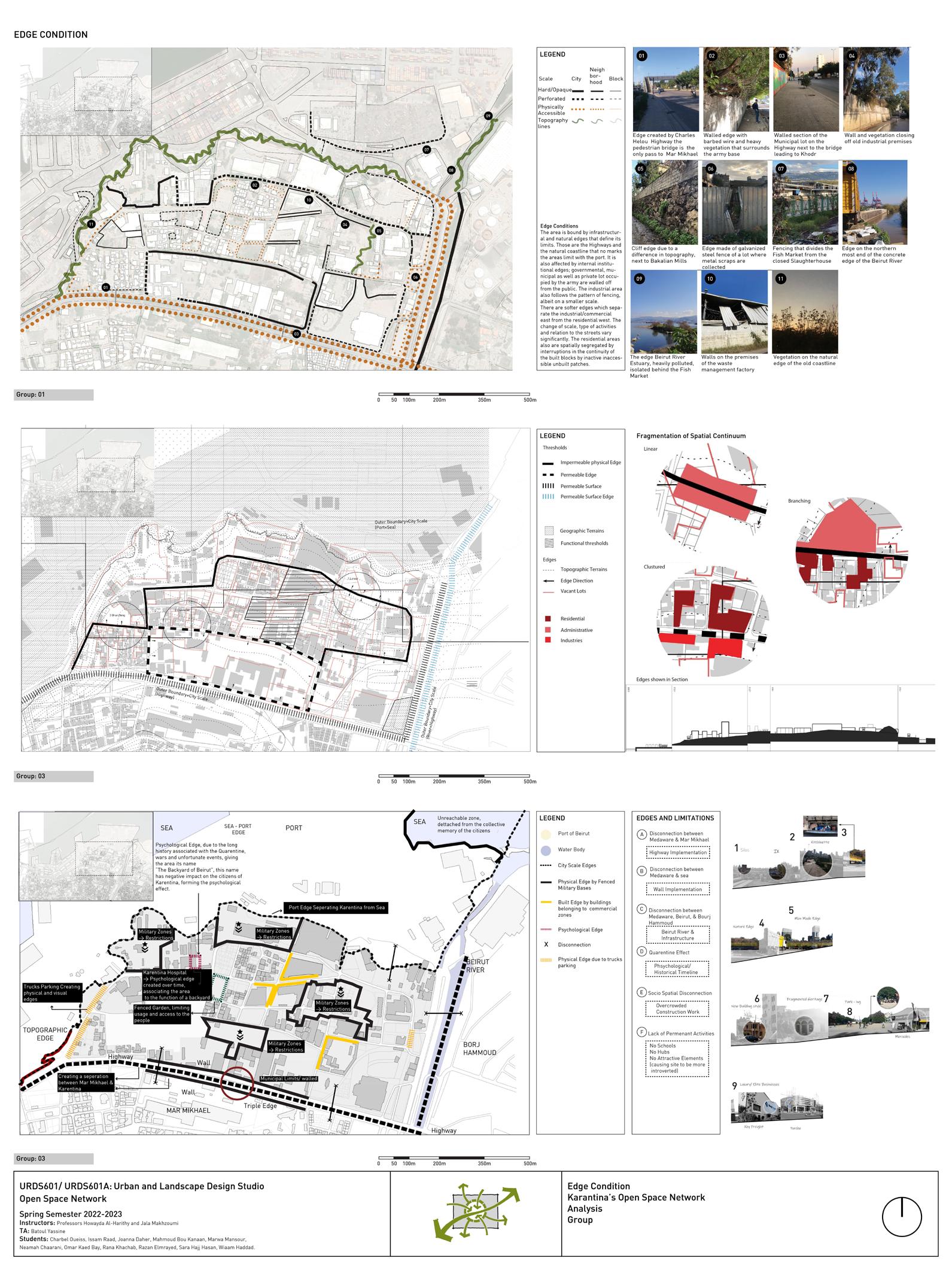
2) Edge Condition (fig.6):
The boundaries of the area are defined by both infrastructure and natural features. These include highways
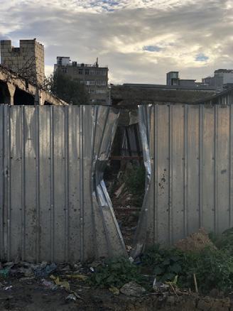
and the natural coastline that marks the area’s limit with the port. Additionally, internal institutional edges such as governmental, municipal, and privately occupied areas by the army are walled off from the public. The industrial area also exhibits a similar pattern of fencing on a smaller scale.
There are also softer edges that separate the industrial and commercial zone in the east from the residential zone in the west. These edges signify a change in scale and type of activities, resulting in a significant variation in the relationship between streets and their surroundings. Furthermore, the residential areas experience spatial segregation due to interruptions in the continuity of built blocks caused by inactive and inaccessible unbuilt patches.
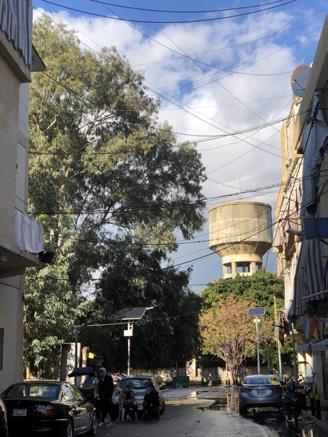
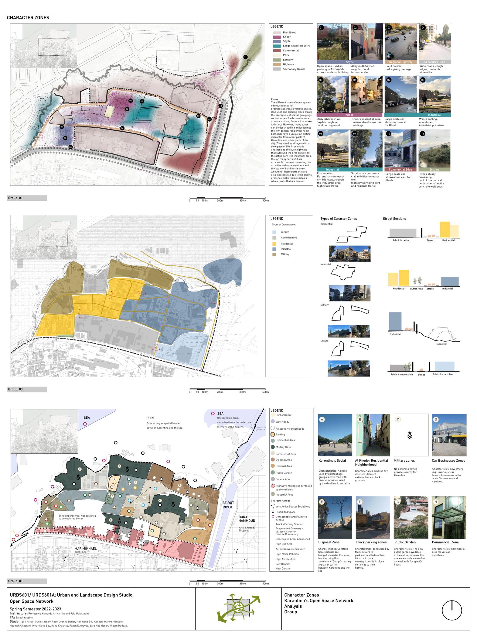
3) Character Zone (fig.4):
The perception of different areas is influenced by the presence of different types of open spaces, edges, socio-spatial practices, as well as varying scales, land uses, and building types. Each zone possesses one or more distinctive features that set it apart. However, it is important to note that many zones can be described using similar terms. For instance, the low-density residential neighborhoods in Karantina have a unique and distinct character that distinguishes them from other parts of Karantina and the city as a whole. These neighborhoods resemble villages with a leisurely pace of life, creating a striking contrast to the bustling highways surrounding the area and the active port. These areas are not welcoming to outsiders, and the sheer size of the buildings can be overwhelming. Additionally, the presence of inaccessible areas due to the presence of the army contributes to the perception of these neighborhoods as a whole.
19
URBAN DESIGN PROJECT 2022-2023
KEY FINDINGS AND ASSESSMENT OF URBAN TRENDS
4) Socio Spatial Practices (fig.3):
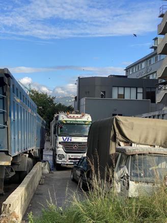
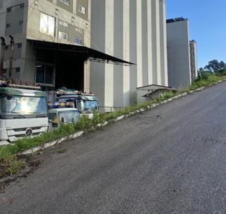
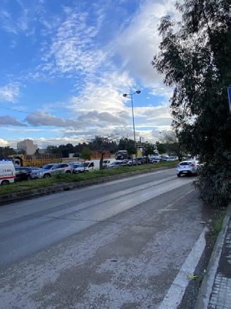
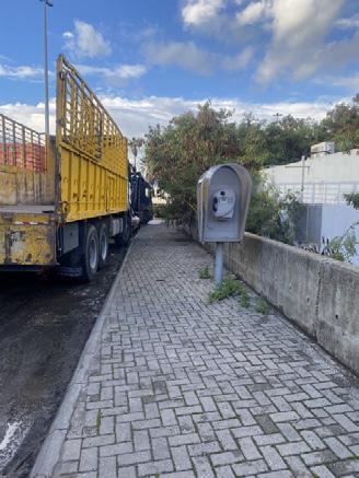
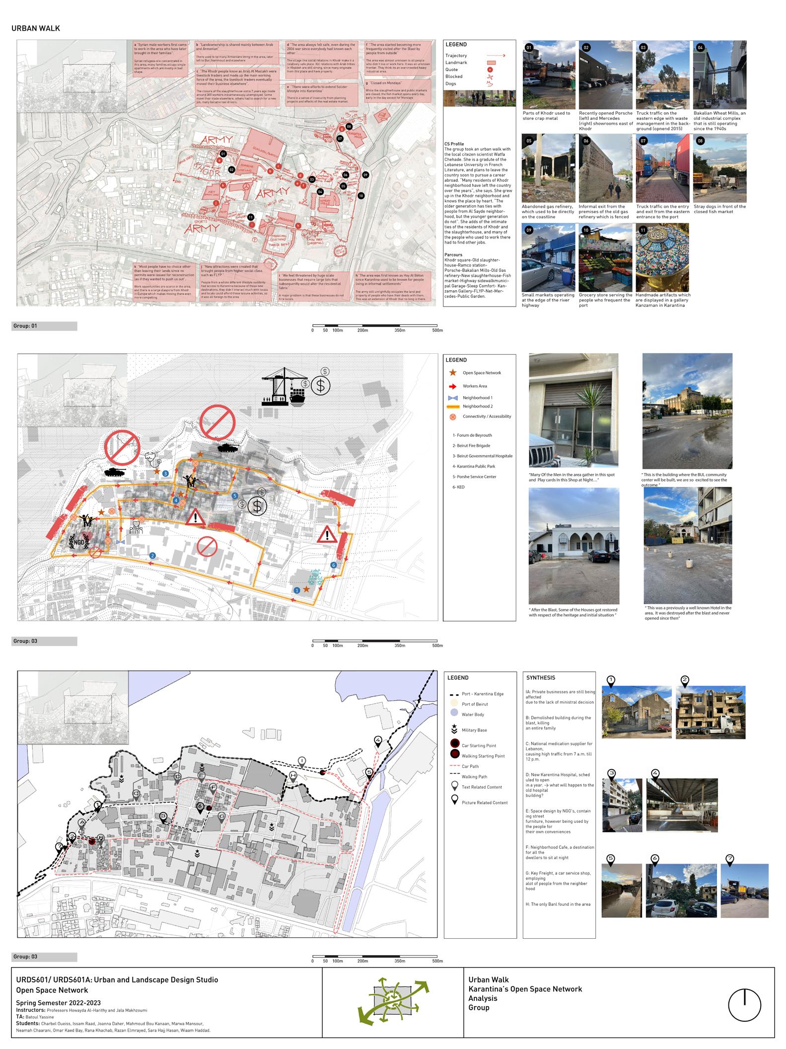
My group observed significant activity occurring at the entrances of the port and in the core residential areas. The presence of truckers was particularly noticeable, creating congestion at the port entrances. Some truckers who arrived late in the day would wait in their designated spots until the port reopened the following morning. There was also activity observed at the fish market, where early morning auctions took place. However, the fish market was closed on Mondays, and the level of activity decreased as the day progressed. Along the river highway, a specific economy had developed, with a coffee shop, grocery store, and small butcher shop catering to vans and passengers making U-turns or exiting the port. On the western edge of Charles Helou highway, there was a small shop that served as an informal stop for vans and buses, located just in front of its door. The Charles Helou highway was frequented by both residents and non-residents, with many trying to reach the bus stops on the other side to travel to and from Mar Mikhael. The Khodr Mosque was a popular destination for locals and passers-by, particularly on Fridays. Military vehicles, such as jeeps, were frequently seen on the inner streets.
Summary of The Problems:
We reached a consensus on formulating a synthesis regarding public open spaces. The synthesis emphasizes that the vacant areas in Karantina hold tremendous value, yet they are also highly vulnerable to changes. These spaces
provide much-needed breathing room, contributing to the village-like atmosphere that characterizes the area. However, the sub-neighborhoods within Karantina continue to be spatially segregated, resulting in limited interaction and engagement among residents from different parts of the area.
The expansive public lots that border or surround Karantina from the north to the south act as static edges or zones that are less susceptible to further development. This situation is largely influenced by the dominant military presence in the area, which contributes to the limited accessibility of these spaces.
Moreover, there is an ongoing dynamic process of largescale industrial encroachment from the east to the west, taking advantage of the available vacant areas. However, many open spaces, particularly the streets, lack adequate maintenance and servicing. Sidewalk obstructions are a common sight, hindering pedestrian movement. Efforts have been made by various organizations to improve the conditions of the streets through infrastructure initiatives, addressing some of these issues.
Trucks pose a significant challenge in Karantina, primarily due to their untimely presence within residential neighborhoods, their utilization of secondary roads, and the resulting traffic congestion. As a result, after defining the problem and analyzing the key findings, and incorporating the initial visions of the groups, the class collaboratively formulated a unified vision. By combining the preliminary visions of the three groups regarding the open space network, the studio effectively reached a visual and verbal depiction of the consolidated vision (fig.9).
20
URBAN DESIGN PROJECT 2022-2023
METHODOLOGY
Instructors: Professors Howayda Al-Harithy and Jala Makhzoumi TA: Batoul Yassine
Compiled by Students: Charbel Oueiss, Issam Raad, Joanna Daher, Mahmoud Bou Kanaan, Marwa Mansour, Neamah Chaarani, Omar Kaed Bay, Rana Khachab, Razan Elmrayed, Sara Hajj Hasan, Wiaam Haddad.
URBAN DESIGN PROJECT 2022-2023
METHODOLOGY
In Phase Two of the report, several methods were employed to analyze and develop the urban design interventions. The first method involved a thorough review of existing literature to gain a comprehensive understanding of the significance and role of open spaces. This theoretical underpinning helped establish the importance of inclusivity, accessibility, and the potential of open spaces to shape urban life and foster cultural identities and collective memories. Next, an assessment of the assets and premises of Karantina was conducted. Despite challenges such as militarization, hard edges, and internal fragmentation, Karantina was found to possess significant assets.
The Plan Vert was proposed as a strategy to enhance public spaces by incorporating nature elements, creating green spaces within neighborhoods, and promoting socio-spatial practices. Existing greenery, the potential for an urban park at the Mar Mikhael station, the repurposing of highways, and the historic coastal cliff were identified as valuable assets to be utilized.
Based on the consolidated vision and assessment, a set of objectives was established. These objectives focused on protecting natural diversity, reviving historic connections, creating pedestrian-friendly spaces, sustaining socio-spatial practices, connecting to the city-scale network, and promoting economic revitalization.
The concept of the “Open Space Network” was then developed, which involved multi-scale interventions to connect Karantina to Beirut City and internally. This concept addressed connectivity at the city, neighborhood, and site scales through various elements such as a maritime prom-
enade, the Beirut River, an Urban Boulevard, the Mar Mikhael Train Station, the Green Path, an active spine, and community streets.
To realize the vision of the network of open spaces, a comprehensive plan featuring urban design interventions was proposed. The primary objective of this plan was to establish a network of public open spaces prioritizing pedestrian accessibility, safety, inclusivity, and efficient services. The plan aimed to connect Karantina internally and reintegrate it with the city of Beirut.
Finally, a mobility strategy and program strategy were developed. The mobility strategy focused on creating a dynamic interaction between community nodes, ecological nodes, and economic nodes. The program strategy encompassed a diverse range of activities, including temporary, open ended, fixed, and socio-ecological programs, to meet the needs of the community, promote ecological sustainability, and support economic activities.
A- Theoretical Underpinning:
After thoroughly reviewing the literature, we have gained an understanding of the importance and role of open spaces. We concluded that open spaces possess characteristics of inclusivity and accessibility for the general public. These spaces provide platforms for expressing cultural identities and fostering collective memories. It was evident that a network of open spaces has the potential to reshape urban life. Additionally, open spaces are influenced by historical events and act as containers and generators of shared memories. Assets and Premises:
21
URBAN DESIGN PROJECT 2022-2023
Despite the challenges posed by militarization, hard edges, and internal fragmentation, Karantina possesses significant assets. The Plan Vert, builds upon the existing greenery in close proximity to Karantina. This plan aims to enhance public spaces by incorporating elements of nature into the city, creating green spaces within neighborhoods, and promoting socio-spatial practices through a cohesive and continuous green fabric. The implementation of this grid, which is based on the existing landscape heritage of Karantina, seeks to structure and expand it, establishing connections that can mitigate the impact of urban densification in Beirut.
According to the Plan, Karantina is designated as an area suitable for greening due to its abundant vegetation. One notable proposal involves the creation of an urban park at the Mar Mikhael station located just south of the municipal lot in Karantina, across the highway. This urban park would be connected to the existing trail that was once used by trains, but now features overgrown vegetation in several abandoned sections. Since the rail track trail is public land, this proposal is feasible. Additionally, the highways, while acting as a significant barrier to Karantina’s connection with the rest of the city, occupy a considerable area that could be repurposed for other uses while addressing current functional needs. Lastly, the historic coastal cliff of Karantina, which overlooks the sea and port, should also be considered as a valuable asset.
B-
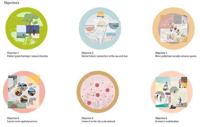
Objectives:
Upon developing a consolidated vision, the studio set a list of objectives. Studio’s objective dealt with both the existing assets and the key problematic findings to come up with six objectives on the open space network:
1. Protect the green heritage/ Natural diversity
2. Revive historic connection to the sea and river
3. More pedestrian inclusive spaces
4. Sustain socio-spatial practices
5. Connect to the city scale network
6. Economic revitalization
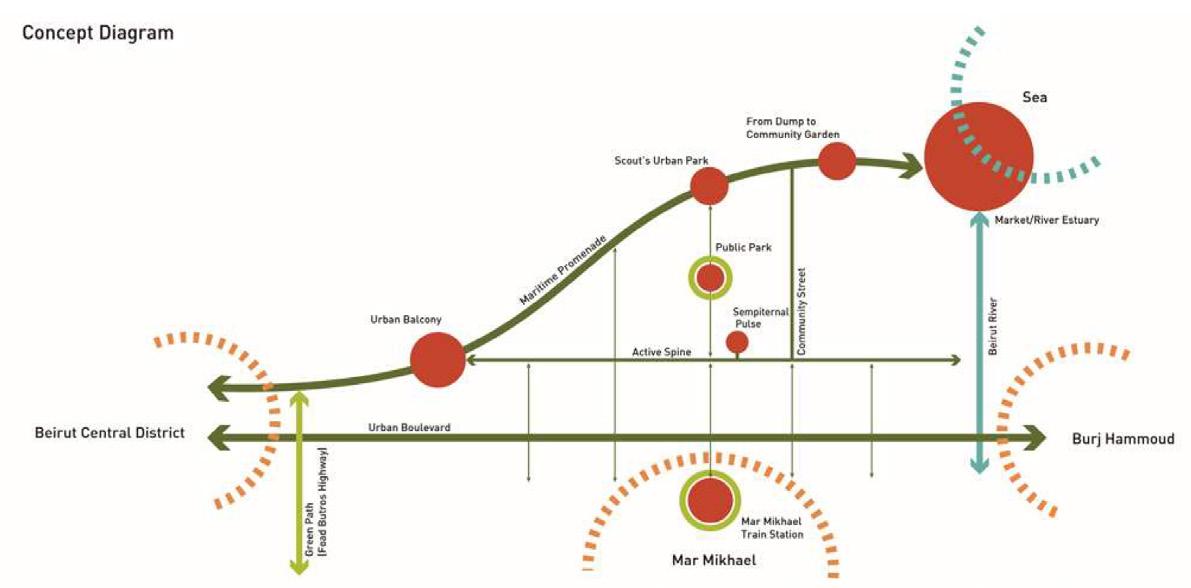
C- Concept:
After developing a vision, setting objects, and gathering
information on existing data it is crucial to say that the “Open Space Network” is a multi-scale intervention that connects Karantina to Beirut City and internally (fig.10).
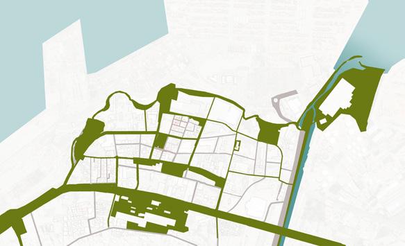
1. City Scale: At the city level (Beirut Central District and the Sea) through a maritime promenade reaching the estuary.
2. Neighborhood Scale: At the neighborhood level (Karantina-Burj Hamoud-Mar Mikhael), it connects through the Beirut River, an Urban Boulevard, Mar Mikhael Train Station, and the Green Path.
3. Site Scale: At the site scale it also integrates within the Karantina neighborhoods through an active spine and community streets.
22
Figure 7. After Identifying the Problem and Stating the Vision, we jumped into Theoretical Underpinning.
Figure 8: Foaud Boutros Road - Plan Vert- Assets
URBAN DESIGN PROJECT 2022-2023
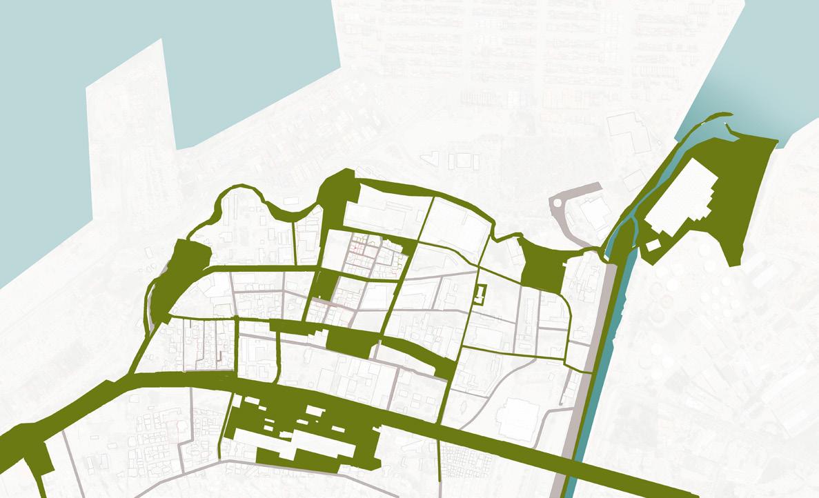
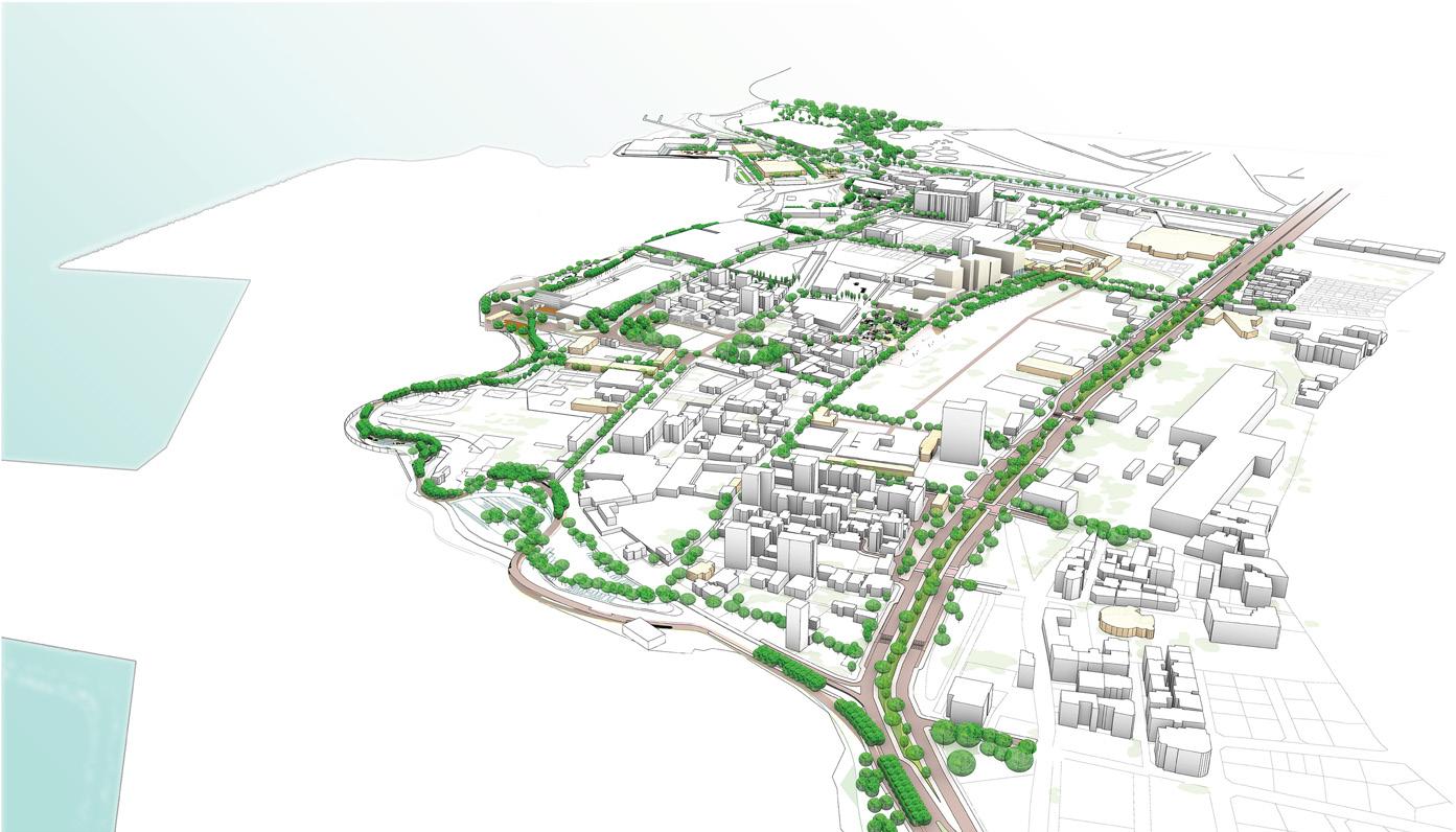
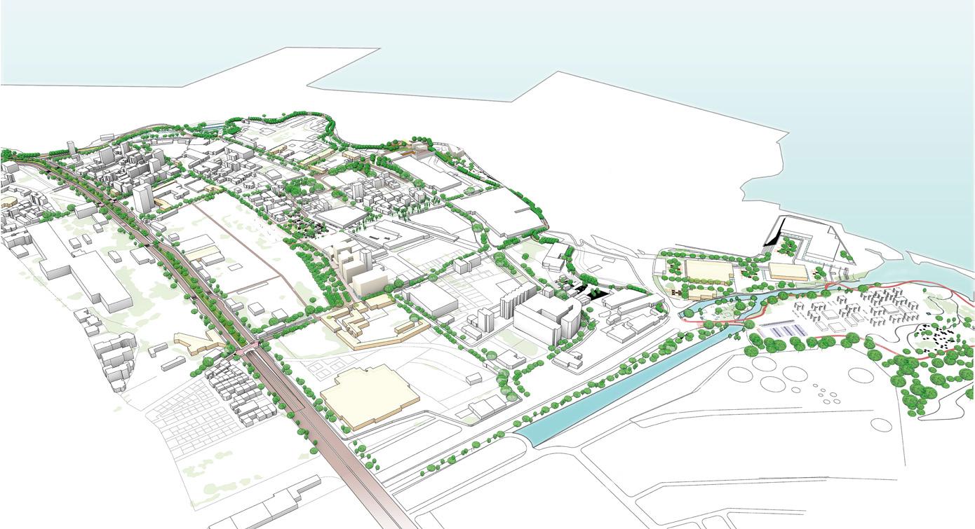
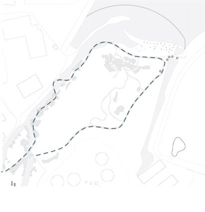
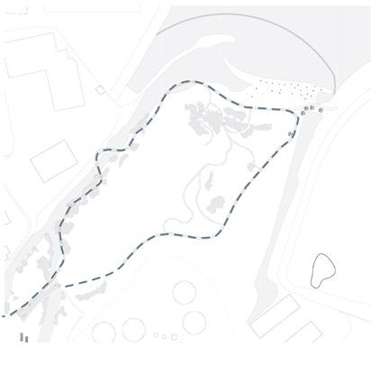
D- Network of Open Spaces (fig.11):
The suggested project consists of a comprehensive plan featuring various urban design interventions that are recommended for execution. The primary goal of this urban
design scheme is to establish a network of public open spaces that prioritize pedestrian accessibility, safety, inclusivity including efficient services. This network will connect Karantina Internally and connect it back to the city Beirut.
23
Figure 9. Objectives in Phase 2.
Figure 10. Concept Diagram. Dealing with the open space network by infiltration, connection, and stitching.
Figure 11. Proposed Open Space Network. Phase II.
URBAN DESIGN PROJECT 2022-2023
E- Mobility Strategy:
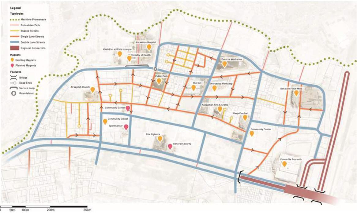
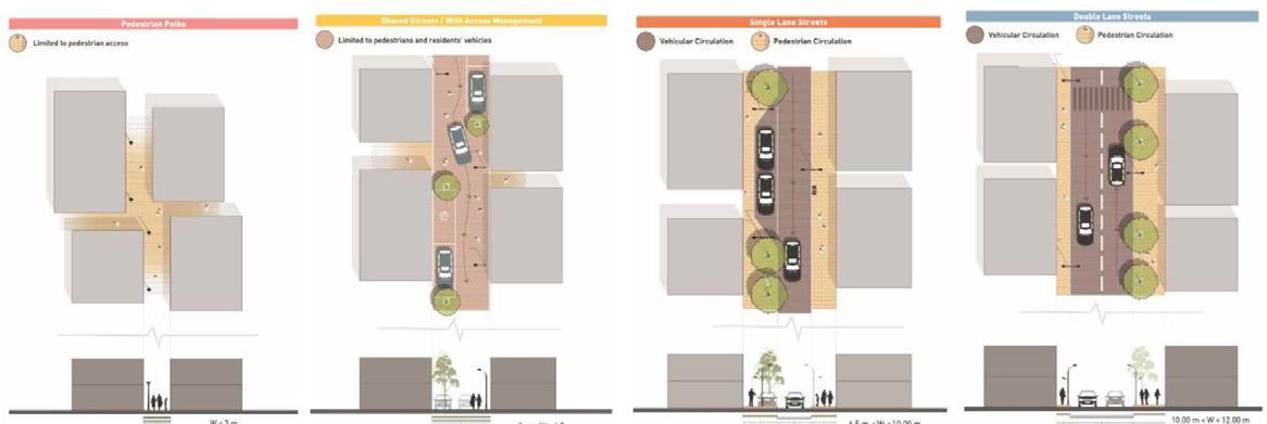
Figure 12. The proposed mobility network was developed by considering the current street widths, which were determined by the existing plot limits. Based on this assessment, the project recommends designating streets as pedestrian-only, single-lane, or double-lane, depending on their size. The overall objective of the project is to establish a pedestrian-friendly network of public open spaces that improves the urban fabric of Karantina and enhances connectivity. Additionally, the mobility strategy includes the suggestion of street typologies that align with these objectives.
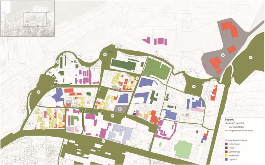
F- Program Strategy:
The open space network program fosters a dynamic interaction between community nodes, ecological nodes, and economic nodes. This program encompasses a range of activities, including temporary programs, open-ended and fixed programs, as well as socio-ecological programs B-1. By incorporating these diverse program types, the open space network aims to accommodate the needs and aspirations of the community while promoting ecological sustainability and supporting economic activities (fig.15).
24
Figure 13. Pedestrian Path Shared Street with Access Management Single Street Lane Double Lane Stree
URBAN DESIGN PROJECT 2022-2023
Figure 14. Program Strategy – Phase II.
URBAN DESIGN PROJECT 2022-2023 25

Compiled by Students: Charbel
Issam
DESIGN PROPOSAL
Instructors: Professors Howayda Al-Harithy and Jala Makhzoumi TA: Batoul Yassine
Mahmoud Bou
URBAN DESIGN PROJECT 2022-2023
26
Oueiss,
Raad, Joanna Daher,
Kanaan, Marwa Mansour, Neamah Chaarani, Omar Kaed Bay, Rana Khachab, Razan Elmrayed, Sara Hajj Hasan, Wiaam Haddad.
DESIGN METHODOLOGY
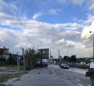
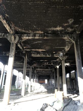
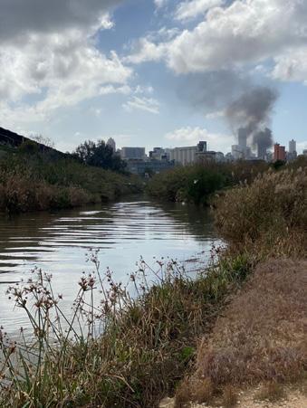
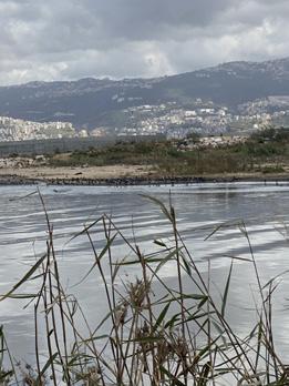
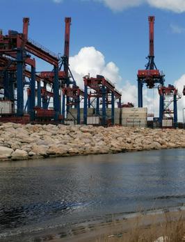
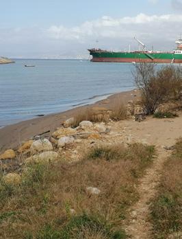
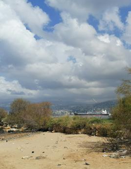
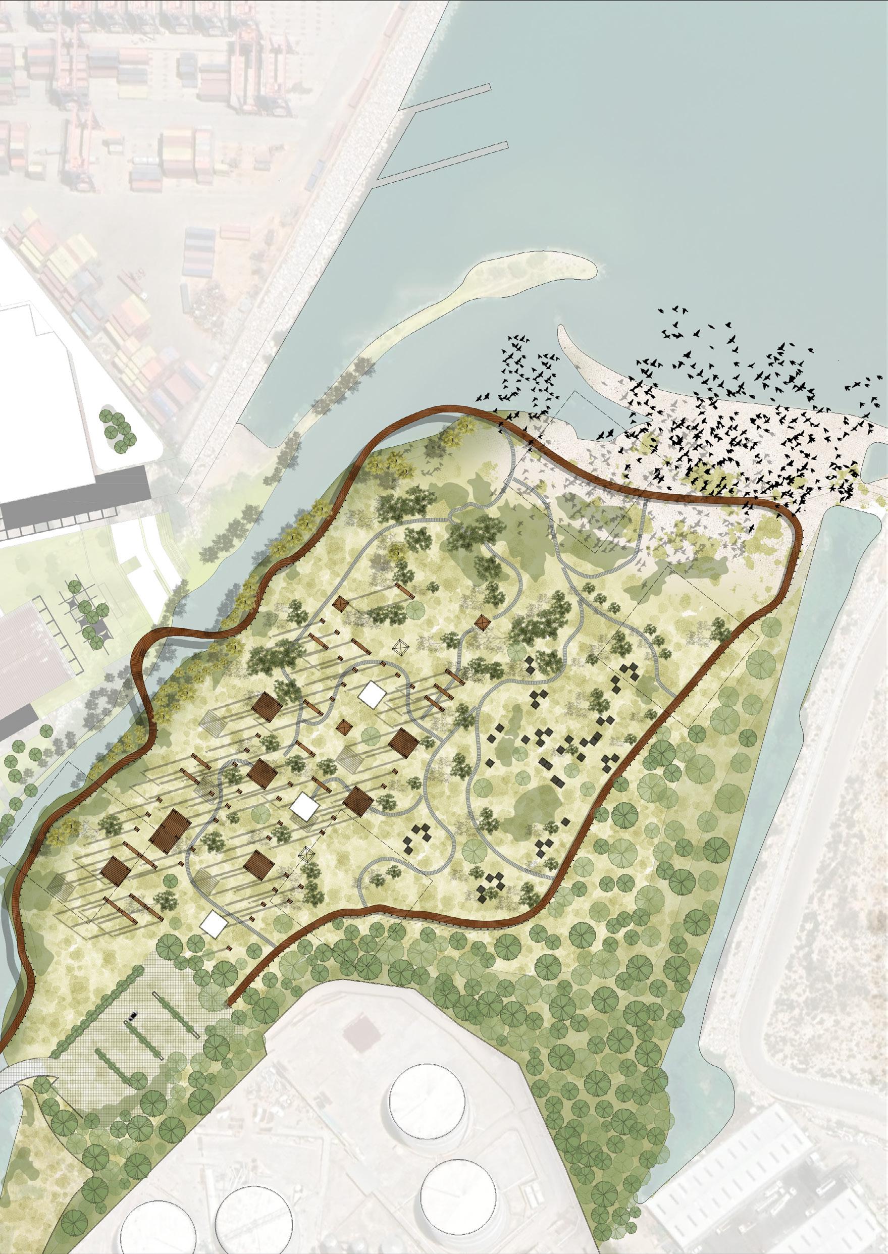
The methodology for this section of the urban design intervention report involves several key steps. The initial step is to choose a network of spaces for strategic intervention, with a focus on public spaces as the starting point. The specific focus of the design proposal is on the Estuary of Beirut, which is identified as a significant ecological area and the last remaining natural space in the city. The report identifies various critical issues affecting the estuary, such as infrastructure deficiencies, limited accessibility, the presence of hazardous zones, and pollution from nearby shipping activities.
To address these issues, a comprehensive design approach is developed, incorporating considerations of land use, socio-spatial practices, edges, and the establishment of a sustainable ecological sanctuary. The analysis of land use reveals infrastructure deficiencies and areas that are currently non-accessible and densely populated with random vegetation. Socio-spatial practices are observed, mainly centered around the bridge and the Fish Market, while certain areas remain inaccessible. The edges of the estuary are characterized by strong industrial and urban boundaries, emphasizing the need for a buffer zone to protect the bird habitat.
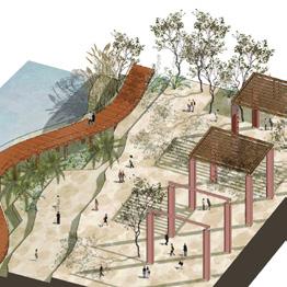
The proposed intervention, titled “Haven: A Sustainable Ecological Sanctuary for All,” aims to create a safe and
welcoming space that prioritizes ecological well-being for both humans and the natural inhabitants of the estuary. The vision is to transform the estuary into a sustainable ecological sanctuary that contributes to the overall well-being of the community and revitalizes the ecological fabric of Beirut.
The methodology involves a systematic approach, including building a neighborhood profile, conducting a strategic diagnosis, developing an urban recovery strategy, articulating action plans, and designing an indicator system for monitoring and assessment. The design proposal is based on in-depth analysis, insights from urban trends, and a vision for Karantina as a network of open and public spaces accessible to all residents, with a focus on ecological sensibility, socio-cultural activity, and economic viability. By combining key findings, assessment of urban trends, and a comprehensive design approach, the intervention aims to create a future for Karantina that is inclusive, sustainable, and respectful of its ecological and cultural heritage. The proposed design strategies and objectives aim to enhance the ambience, promote accessibility, facilitate restful socio-spatial practices, cultivate active and diverse programs, and restore and preserve the natural ecosystem, ultimately creating a thriving urban environment.
27
URBAN DESIGN PROJECT 2022-2023
V. Proposed General Urban Strategy & Detailed Policy Recommendations for Urban Intervention
Choosing a network of spaces for strategic intervention is a crucial initial step. Public spaces serve as the starting point, where the shared memories and communal activities of the past can serve as inspiration for envisioning the neighborhood’s future. In addition to their practical significance, public spaces play a vital role in the broader story of the city. They encapsulate historical cultural and social events, acknowledge trauma and devastation, and provide a platform for imagining the future landscapes of the neighborhood or city.
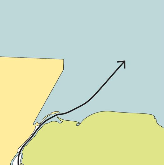
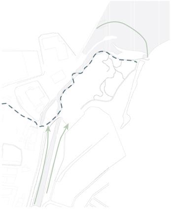
Our design proposal focuses on the Estuary of Beirut, which holds significant ecological value as the last remaining natural area and open space in the city. This area is home to diverse species and natural habitats that require protection and preservation. In our effort to address the environmental challenges and enhance the site’s functionality, we have developed a comprehensive design approach that incorporates considerations of land use, socio-spatial practices, edges, and the establishment of a sustainable ecological sanctuary (fig.1).

28
URBAN DESIGN PROJECT 2022-2023
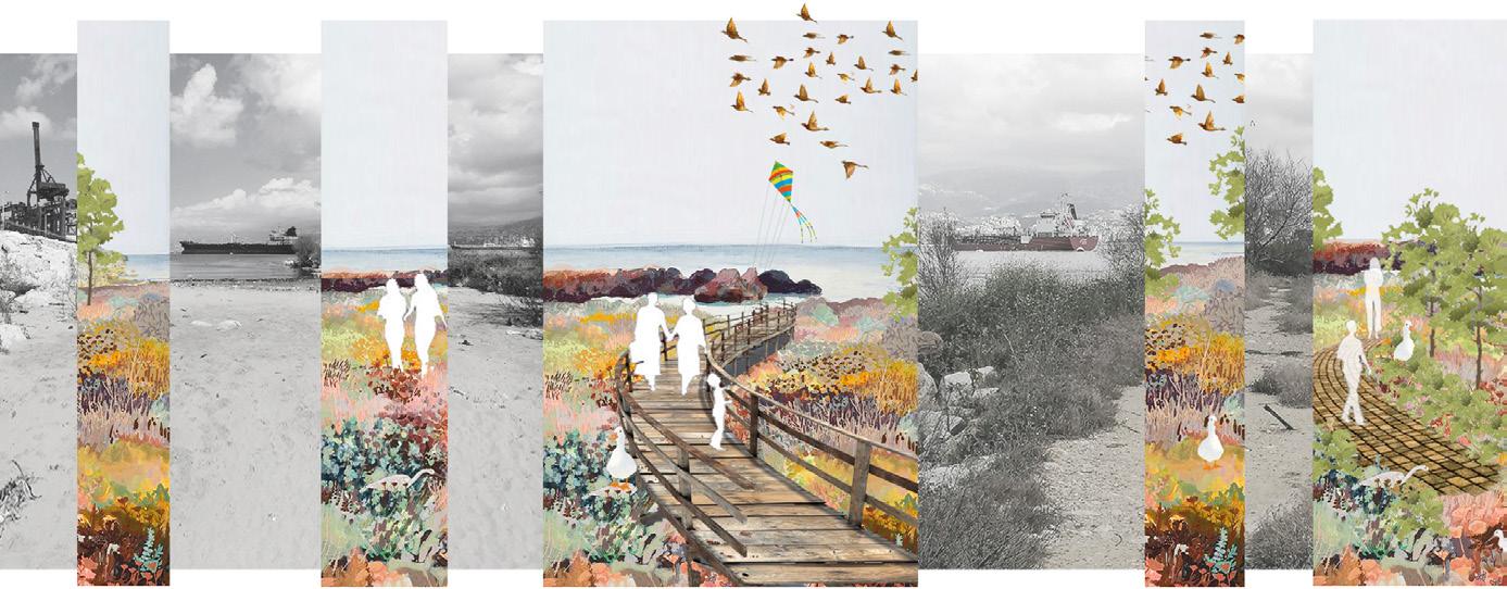
Figure 15-The Estuary location with respect to the green promenade of Karantina. Location with respect to the network of open spaces.
PROBLEM DEFINITION
Estuaries represent distinct and highly productive ecosystems where the convergence of rivers and the sea forms a transitional region between freshwater and saltwater environments. These areas hold significant importance as they offer a wide range of ecosystem services, which encompass the benefits that humans obtain from natural ecosystems. These services include the provision of tangible goods like water and timber, the regulation of climate, the support of soil recycling processes, and the provision of recreational opportunities. Unfortunately, estuaries are particularly susceptible to the adverse effects of climate change, such as rising sea levels, intensified storms, and alterations in precipitation patterns. However, the implementation of green infrastructure can contribute to both mitigating and adapting to these impacts in various ways. Estuaries play a vital role in the recycling of water and nutrients, serving as essential habitats for the growth and development of fish and wildlife. Moreover, they exhibit significant biodiversity and serve as recreational spaces for both humans and animals. In urbanized regions, estuaries also serve as valuable flood mitigates, safeguarding coastlines from erosion and other destructive consequences of flooding. By recognizing and harnessing the multifaceted benefits of estuaries, sustainable management practices can be employed to protect and enhance these vital ecosystems in the face of ongoing environmental challenges.
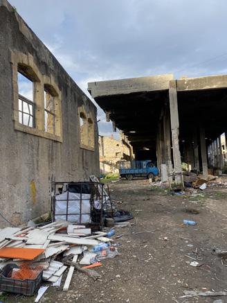
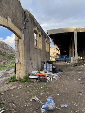
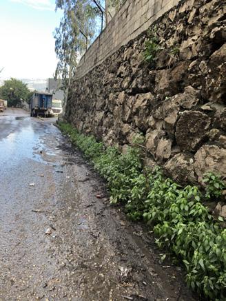
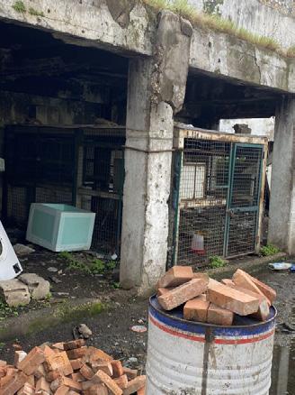
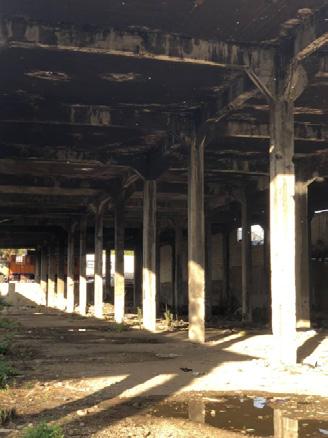
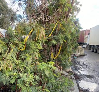
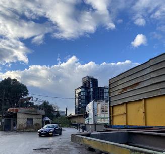
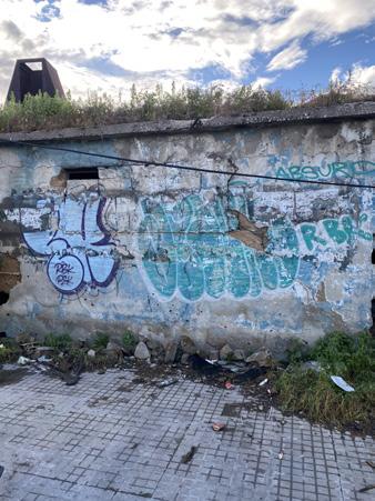
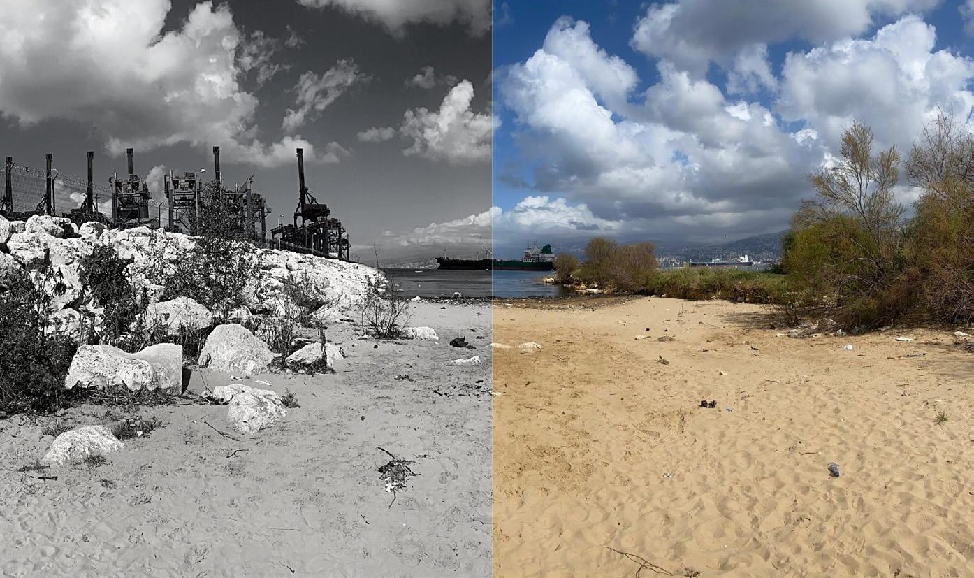
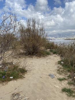
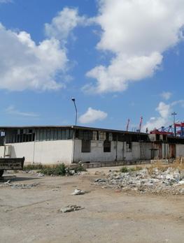
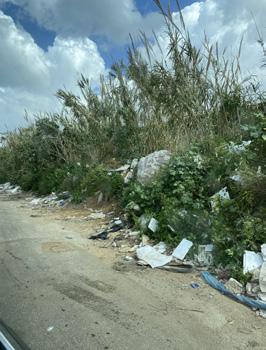
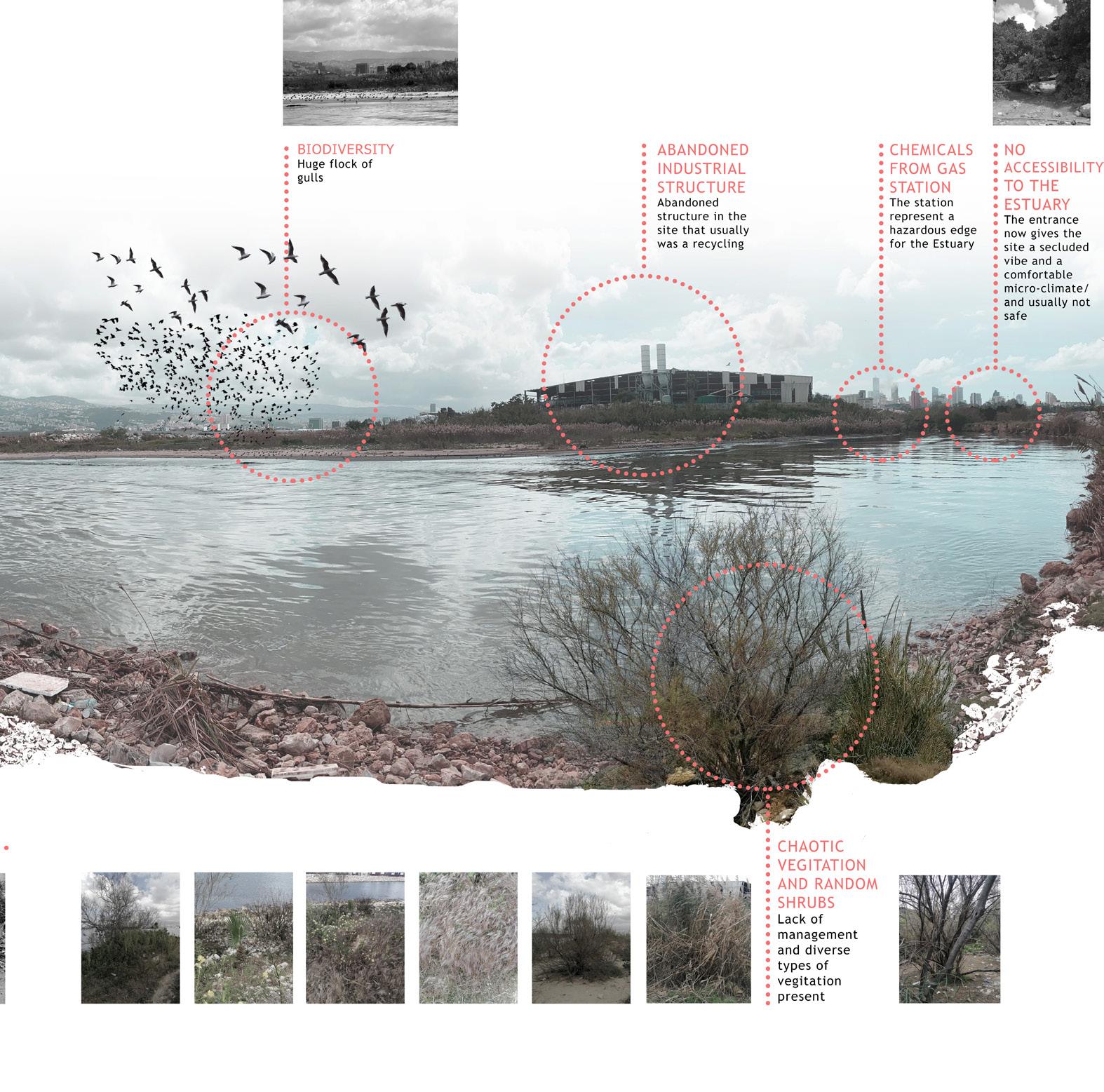
The urban design intervention in the estuary of Beirut in Karantina addresses various critical issues that have adversely impacted the area. One significant concern is the presence of an abandoned industrial structure that was previously used for recycling purposes. This structure stands as a symbol of neglect and abandonment, requiring careful attention in the intervention process. Additionally, the neighboring gas station poses a serious threat to the estuary as it emits hazardous chemicals, contributing to the degradation of the surrounding environment. The lack of accessibility to the estuary further exacerbates the situation, creating a secluded atmosphere and a micro-climate that may seem comfortable but is not safe for public use. The presence of shipping activities in the nearby sea has resulted in pollution, significantly impacting the water quality of the estuary (fig.15). The sea water is highly polluted, affecting the ecological balance of the area and posing risks to both human and natural inhabitants (fig.16). Moreover, the estuary suffers from chaotic vegetation and random shrubs, highlighting the lack of proper management and maintenance (fig.17). Addressing these issues through urban design intervention is crucial to restore the estuary’s ecological health, improve accessibility, mitigate pollution, and establish a well-managed and diverse vegetation system that harmonizes with the surrounding environment (fig.17).
29 URBAN DESIGN PROJECT 2022-2023


30
Figure 16- The Estuary is located between two different typologies, the heavy industrial area & the vital light green area.
DESIGN PROJECT 2022-2023
Figure 17& 18. Spontaneous Greenery- Pollution in the Estaury
URBAN

PROBLEM DEFINITION
Situated amidst a dense industrial zone and a pristine bird habitat, the site represents a sanctuary caught in the midst of contrasting forces. Recognizing the significance of this unique space, there arises an imperative to safeguard and convert it into an ecologically protected area, preserving its natural beauty and fostering a harmonious coexistence between industry and nature.
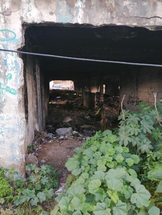
The entrance to the site exudes an air of seclusion and privacy (fig.5), akin to a concealed gateway leading to a hidden sanctuary. This discreet entrance serves as a mysterious threshold, inviting individuals to venture into a
world of tranquility and solace, where they can discover the hidden wonders of this enchanting haven.
Exploring the site was a captivating adventure, unveiling breathtaking and unspoiled pockets of nature nestled amidst the harmonious presence of vibrant birdlife and the serene sea. Each step brought us closer to discovering the beauty of untouched landscapes, immersing ourselves in a world where the captivating symphony of birdsong and the gentle caress of ocean breezes became our constant companions.
31
URBAN DESIGN PROJECT 2022-2023
Figure 19-Collage of the Estuary showing the main problems and identifying their location.
Analysis: Land use
The land use analysis reveals several critical aspects that need to be addressed within the Estuary of Beirut. Firstly, the site’s secluded accessibility has led to the development of a unique micro-climate, but it has also resulted in a lack of proper infrastructure for accessibility, drainage, and wastewater management. Additionally, there are specific areas within the site, such as the Gulls habitat and the buffer dangerous zone, which are currently non-accessi-
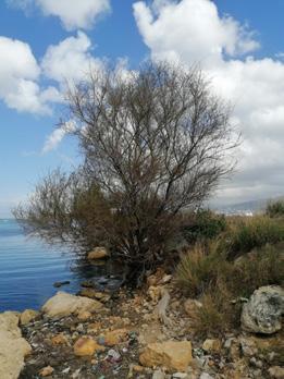
ble and have become densely populated with random vegetation (fig.6). The site hosts an abandoned building of decaying steel structure. The building was initially used as a waste recycling building. Moreover, the Beirut River floods every winter and rises around 3 meters. What characterizes the site that it is rich with spontaneous greenery everywhere along the river bed.
The estuary is bounded by a hazardous zone from South. The hazardous zone is the CORAL Gas Station that produces pollution and affect negatively the site.
32
URBAN DESIGN PROJECT 2022-2023
01. Accessibility to the site is secluded that it gave a micro-climate to the site. Also, no proper infrastructure in the site in terms of accessibility, drainage, and waste water management.
02. Gulls habitat is located at the North of the site. It is not accessible for public nor private.
03. Non-accessible area and currently its densified with random vegetation.
04. Buffer dangerous zone. Currently abandoned and its densified with random and spontaneous vegetation.
Socio Spatial Practices
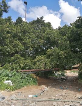
The socio-spatial practices observed within the Estuary (fig.7) are mainly centered around the bridge, where truck workers from the Port gather and utilize the river bed as a parking area.
The presence of the Fish Market also attracts people to the site on a daily basis. However, certain areas, such as the bird habitat and the hazardous zone of the CORAL Gas Station, remain inaccessible and devoid of any socio-spatial activities. The abundance of spontaneous greenery throughout the site has also posed challenges in terms of access.
People are located on the bridge mainly, which are truck workers that work for the Port. They use the sides of the River bed to park the trucks. The presence of the Fish Market also attracts some people on daily basis.
The Birds natural habitat is located at the North of the Estuary. The birds hunt and breed in the same area. This area is not accessible by vehicles nor by pedestrians. However, this area should be protected and designed to be beneficial for both, humans and Sea Gulls. The Coral Gas Station does not host any socio spatial activities because it’s a dangerous zone and it’s not accessible. However, the whole site was hard to access due to the spontaneous greenery everywhere, which was huge in height and size. The West side of our Estuary is accessible, which helped us gather data on our site. The Sensul host several socio spatial practices. For example, some fishermen use it as a fishing area. They then sell their fishes in the fish market
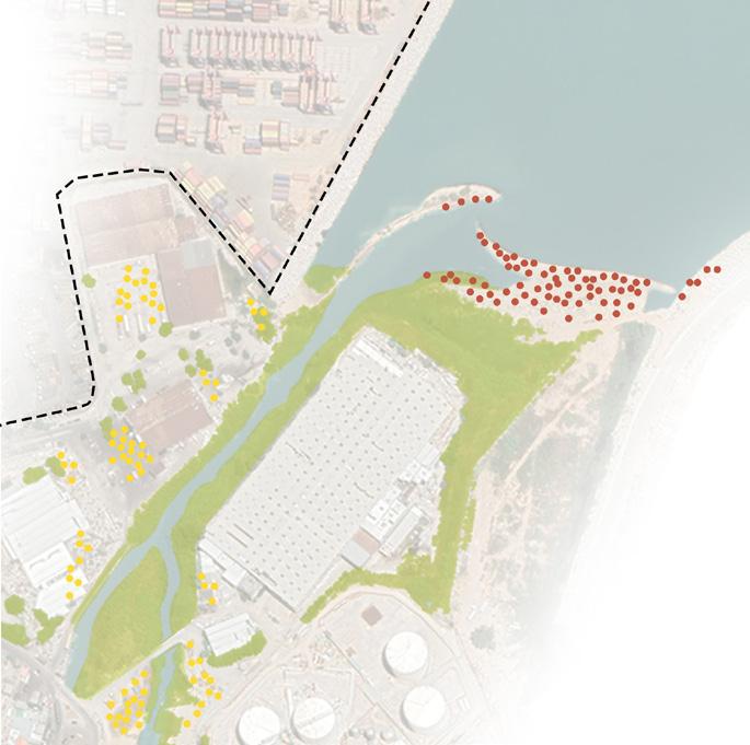
nearby. Moreover, some young adults use this area as fire night place. The Sensul should be designed for people to use safely and create a suitable infrastructure.
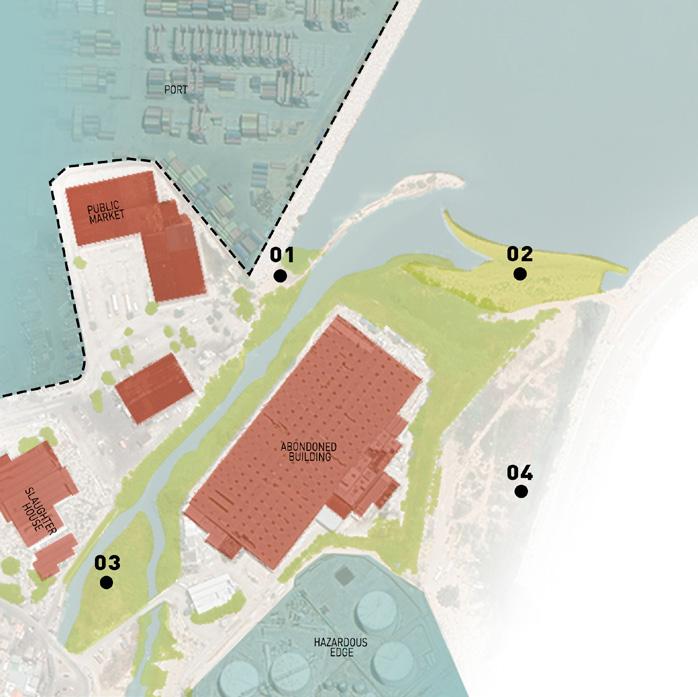
Edges
In terms of edges (fig.8), the Estuary is bordered by strong industrial and urban edges from the west, south, and east, while the soft water edge defines its northern boundary. To ensure the protection of the bird habitat, it becomes crucial to establish a buffer zone that separates it from the hazardous area. The site is bounded by a strong Industrial Edge, which is the Port and the CORAL Gas Station from the West and South. We also can recognize the Soft Water Edge that bound the site from the North. We should also notice the strong Urban Edge in the site from the East and the West. We can also deduce that we need to create a buffer zone that separates the bird habitat and the hazardous zone.
The study employed a systematic approach, consisting of five key steps: building a neighborhood profile, conducting a strategic diagnosis, developing an urban recovery strategy, articulating action plans, and designing an indicator system for monitoring and assessment. Through this process, the reports generated in-depth analysis and insights into critical aspects of urban development, including affordable housing and social inclusion, spatial and social connectivity, cultural and economic vitality, inclusive and sustainable development, and the quality of the urban environment.
33
Figure 6
URBAN DESIGN PROJECT 2022-2023
Figure 7. Socio-spatial activities at the estuary.
To realize this vision, the design proposal focused on the Estuary of Beirut, a significant ecological area and the last remaining natural space in the city. This location was identified as crucial for protection and preservation, as it housed diverse species and natural habitats. However, the Estuary faced various challenges, including infrastructure deficiencies, limited accessibility, and the presence of hazardous zones. Addressing these issues while ensuring the ecological wellbeing of the area became paramount. The proposed intervention, titled “Haven: A Sustainable Ecological Sanctuary for All,” aimed to create a safe and welcoming space that prioritizes the ecological integrity of the Estuary while accommodating the needs and activities of both humans and the natural inhabitants of the area. Through careful design strategies and considerations at different scales, the proposal aimed to enhance accessibility, provide rest and socio-spatial practices, create recreational spaces, preserve the bird habitat, and establish platforms for fishermen. Ultimately, the objective was to transform the Estuary into a sustainable ecological sanctuary that contributes to the overall well-being of the community and revitalizes the ecological fabric of Beirut. By combining the key findings and assessment of urban trends with a comprehensive design approach, the study and subsequent design proposal aimed to envision a future for Karantina that is inclusive, sustainable, and respectful of its ecological and cultural heritage.
Key Issues: The reports analyzed five key issues in-depth: affordable housing and social inclusion, spatial, economic, and social connectivity, cultural and economic vitality, inclusive and sustainable development, and the quality of the urban environment.
Vision for Karantina: The Advanced Design Studio aimed to create a vision of Karantina as a network of open and public spaces accessible to all residents. The focus was on ecologically sensible design, socio-cultural activity, and economic viability to create a well-connected destination. Estuary of Beirut: The Estuary is the last remaining natural area in Beirut, hosting diverse species and natural habitats. It requires protection and preservation. Public
spaces serve as the starting point for envisioning the future of the neighborhood. They hold shared memories, foster communal activities, encapsulate cultural and social events, acknowledge trauma, and provide a platform for imagining the neighborhood’s future landscapes.
The Estuary faces challenges related to infrastructure, accessibility, drainage, and wastewater management. Specific areas like the Gulls habitat and buffer dangerous zone are currently nonaccessible and densely populated with random vegetation. Socio-spatial practices mainly revolve around the bridge and the Fish Market. The bird habitat and the hazardous zone of the CORAL Gas Station remain inaccessible. Spontaneous greenery throughout the site poses challenges for access.
The Estuary is bordered by strong industrial and urban edges from the west, south, and east. The northern boundary is defined by a soft water edge. The protection of the bird habitat requires the establishment of a buffer zone.
34
Figure 8
URBAN DESIGN PROJECT 2022-2023
Figure 9. Vision for the Karantina Estuary.
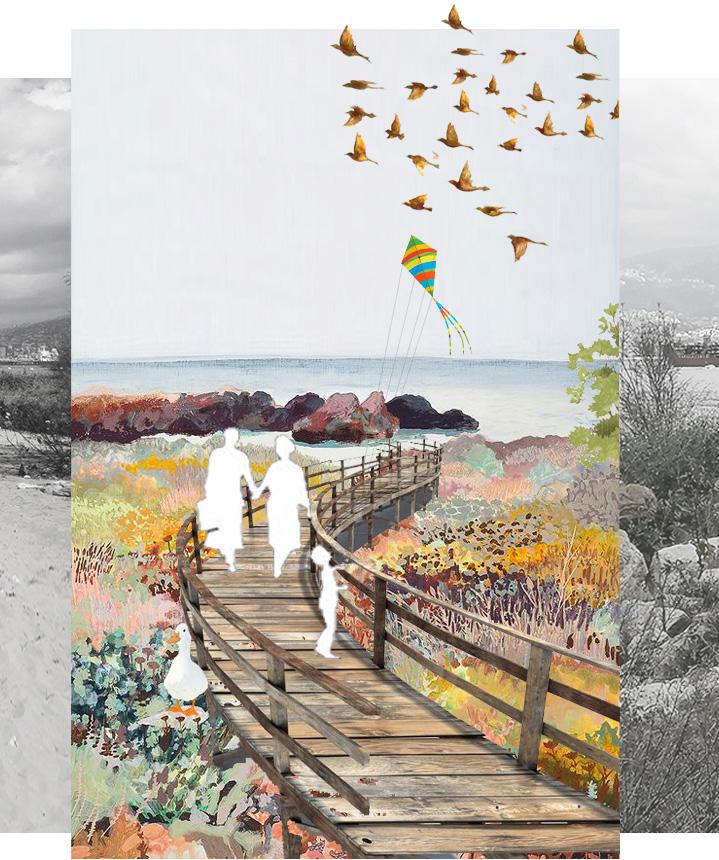
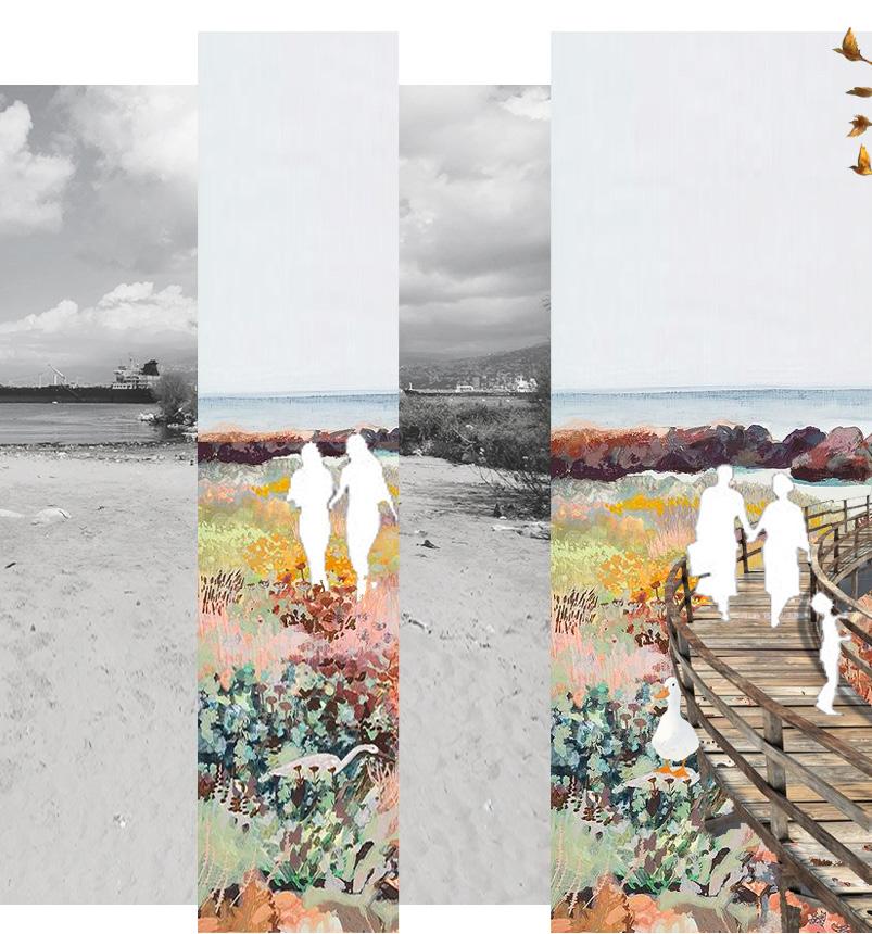
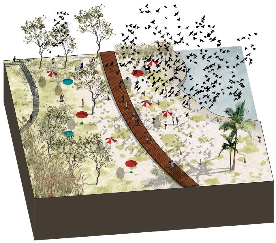
VISION: HAVEN: ‘A SUSTAINABLE ECOLOGICAL SANCTUARY FOR ALL’
The title “Haven” implies a place of safety and refuge, while “sustainable ecological sanctuary” emphasizes the focus on the environment and the goal of creating a space that promotesecological well-being for people, birds, and fish. Adding “for All” indicates that the space is meant to be accessible and welcoming to everyone (fig.9).
Our design proposal, titled “Haven: A Sustainable Ecological Sanctuary for All,” aims to create a safe and welcoming space that prioritizes ecological well-being for both humans and the natural inhabitants of the Estuary. By focusing on accessibility, rest, activity, and nature, we have outlined specific objectives and design strategies to guide our intervention.
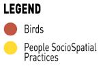
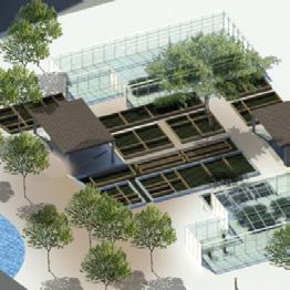
To enhance accessibility, we propose elevated pedestrian pathways, wood rails and pathways, and floating docks and gardens that adapt to the changing water levels. Rest and socio-spatial practices will be facilitated through the installation of benches, pavilions, kiosks, and the provision of accommodations for truck workers. We also emphasize the importance of creating recreational spaces, preserving the bird habitat, and establishing platforms for fishermen. Our design strategies involve extending the green promenade, protecting the bird habitat from pollution, implementing a mechanical collector for oil spillage, and densifying the green edges of the water body. At different scales, we aim to connect the Estuary to existing greening projects, extend the promenade to neighboring areas, and emphasize the estuary’s significance as a city sanctuary.
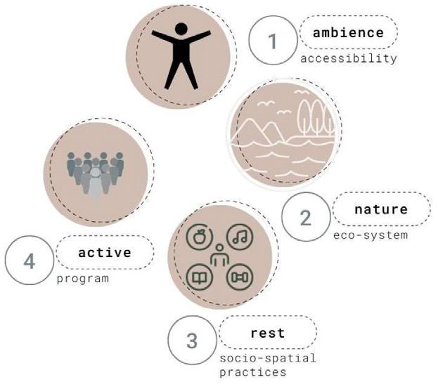
Objectives:
In the realm of urban design, the revitalization and transformation of spaces hold immense potential to create nvironments that foster connectivity, wellbeing, and harmony with nature. In the context of the estuary in Karantina, Beirut, a comprehensive intervention has been devised, guided by a set of urban design objectives. These objectives aim to enhance the ambience, promote accessibility, facilitate restful socio-spatial practices, cultivate active and diverse programs, and restore and preserve the natural ecosystem. By implementing these objectives, the intention is to shape the estuary into a sanctuary that harmoniously integrates people, wildlife, and the surrounding natural elements. This essay delves into the intricacies of each objective, outlining the proposed interventions and their potential to create a sustainable and thriving urban environment (fig.21).
35
URBAN DESIGN PROJECT 2022-2023
Figure 21. Main 4 Objectives.
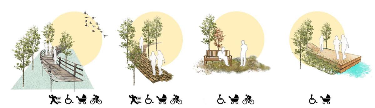

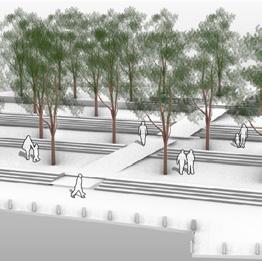
01. Ambience – Accessibility (fig.20):
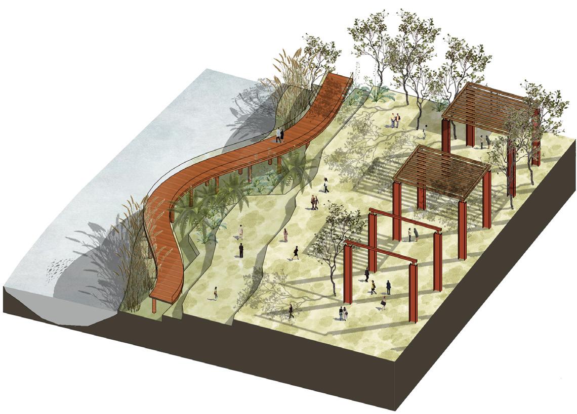
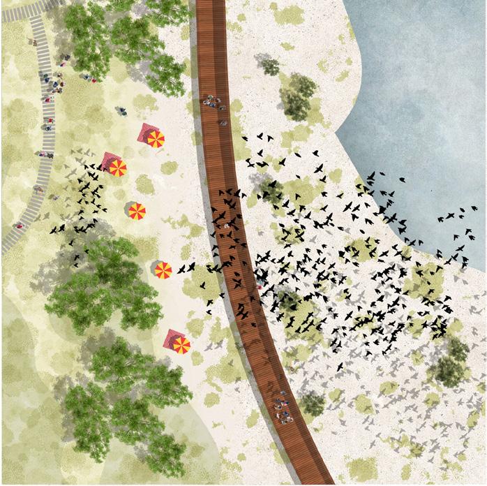
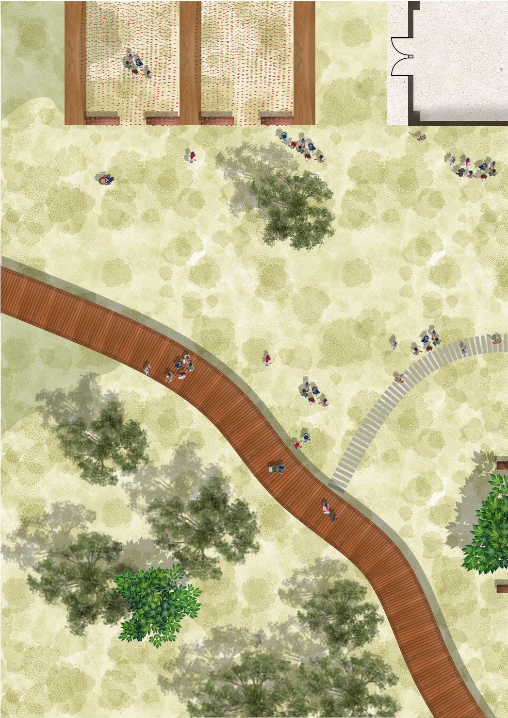
A. Elevated Pedestrian Pathways: The intervention includes simple elevated wood pathways that connect the site into a peaceful promenade around the estuary. people could enjoy the nature, fish, and the birds.
B. Wood Rails and Pathways: The intervention includes simple pathways and steps that do not disturb the site.
C. Accessible for Strollers and Wheelchairs: All people have the choice to rest. the site is accessible by wheelchairs, strollers, and friendly to people with disabilities.
D. Floating Docks and Gardens: We intervene with simple floating docks that will increase exposure to the water and the river body. we respect the elevated water levels during a certain period in the year and elevate our intervention.
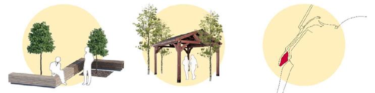
02. Rest - Socio Spatial Practices (fig.22):
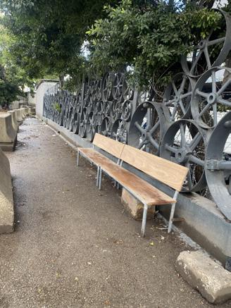
A. Benches: People will be able to enjoy nature at any spot in the estuary. it transforms the estuary into a sanctuary.
B. Pavilions and Kiosks: We distribute kiosks, pergolas, and pavilions all along the site for people to enjoy their random activities.
C. Trucks Accommodations: All people have the choice to rest. the site is accessible by wheelchairs, strollers, and friendly to people with disabilities.
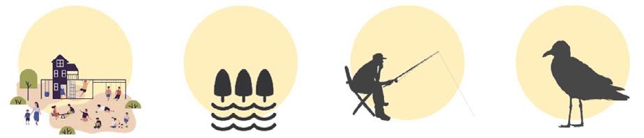
03. Active – Proposed Program (fig.23):
A. Recreational: We introduced playgrounds and open
spaces that will act as recreational spaces that will host people performing multiple hobbies and actions like kids playing, open door yoga, and meditating.
B. Landforms: We’re going to claim the site as a natural ecological site. a sanctuary for birds, fish, and people.
C. Platforms for Fishermen: The site will also host fisherman that can have their area. they can fish in clean protected water.
D. Birds Sanctuary: We want to protect the natural habitat of the birds and the fish. We will do this protecting and preserving the area as an ecological- natural site. we will also clean the water and protect it from oil spillage from the ships.
04. Nature – Eco System (fig.24):
A. Clean: Our aim is to clean the estuary site and the water from waste, pollution, garbage, and oil spillage.
B. Densify: We aim to densify the area to become an ecologically preserved area that contribute to nature and wellbeing. we aim to contribute back to Beirut a natural site.
C. Protect and Program: We aim to protect the area to become an ecologically sustainable and preserved area. we want to introduce recreational activities, like walking and open yoga classes.
36
URBAN DESIGN PROJECT 2022-2023
D
Figure 20. A B C
Figure 23. A B C
D
A
Figure 22.
B C
A
C
Figure 24.
B
Proposed Urban Design Scheme:
Urban design interventions have the power to shape and reimagine urban spaces, fostering sustainability, connectivity, and the preservation of natural elements. In the case of the estuary in Karantina, Beirut, a comprehensive intervention plan has been devised, addressing key objectives to enhance the ecological and socio-spatial aspects of the area. This academic essay explores the proposed urban design interventions and their potential impact on the estuary and its surrounding environment. The objectives include extending the existing green promenade to accommodate socio-spatial practices, utilizing the estuary as a buffer zone to prevent port expansion and protect the natural bird habitat, implementing a mechanical collector to mitigate oil spillage and pollution, and densifying the green edges of the water body to create a richer nature experience and support natural habitats. By delving into each objective, this essay aims to shed light on the transformative potential of urban design in creating a sustainable and harmonious estuary in Karantina, Beirut. Upon careful examination of the available data, our team
made a strategic decision to draw inspiration from successful precedents of afforestation initiatives along Beirut’s river. This choice was driven by the project’s location, which falls within a residential neighborhood. As one moves towards the northern direction, the urban landscape gradually transitions from residential clusters to industrial zones, eventually culminating at the estuary. Within this context, the estuary stands as a remarkable testament to the natural world amidst an otherwise industrialized surroundings of Karantina and its adjacent regions. Consequently, our team resolved to safeguard this invaluable natural estuary and reclaim it as a public space. To achieve this, we adopted a delicate approach, minimizing our interventions on the site while prioritizing the protection of the bird sanctuary. By doing so, we aim to preserve the estuary’s ecological integrity and create a cherished sanctuary that can be enjoyed by all members of the community. This strategic decision reflects our commitment to ecological sustainability, harmonious urban development, and the revitalization of Karantina’s natural landscape.
37
URBAN DESIGN PROJECT 2022-2023
Figure 26. Design a mechanical collector for oil spillage to protect the estuary from pollution.
Figure 25. We want to extend the green promenade and extend it to the site to cater to existing socio-spatial practices by highlighting existing practices.
Figure 28. Densify the green edges of the water body for an enhanced nature experience and to cater for natural habitats. The promenade follows the greenery.
Figure 27. Keep our estuary as the divider/ buffer zone to limit the expansion of the port to keep the natural bird habitat area preserved and protected from pollution.
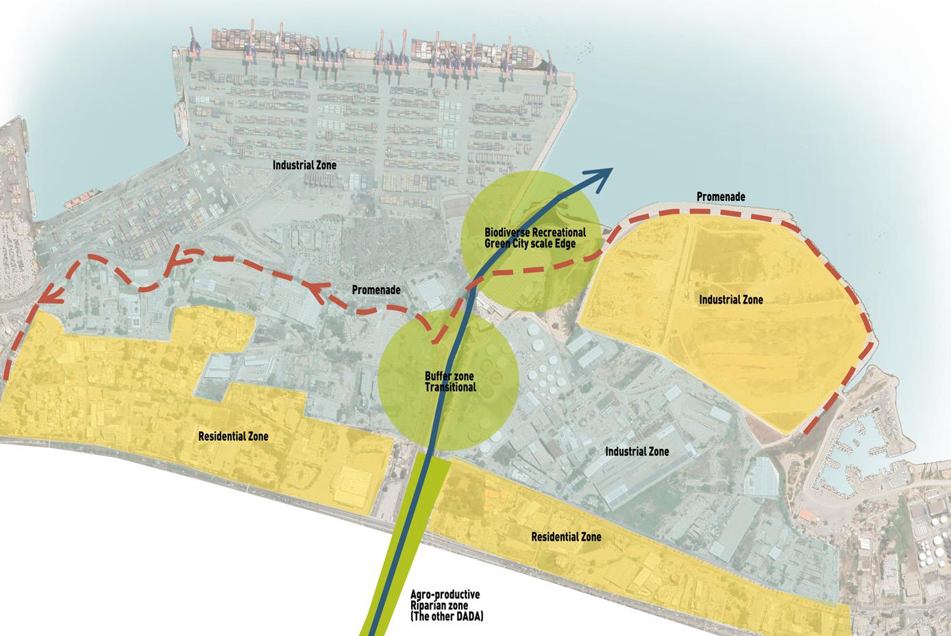
- Regional Scale:
Connect to existing greening projects build a destination area for the residential clusters protect the shoreline mechanically.
- City Scale:
Connect to the extended promenade and the green network extended it to the neighboring areas like Burj Hamoud.
- Site Scale:
Projected city sanctuary that highlights the river and estuary importance.
A Sustainable Ecological Sanctuary:
The design proposal aims to create a safe and welcoming space prioritizing ecological well-being for both humans and natural inhabitants. It focuses on accessibility, rest, activity, and nature, with specific objectives and design strategies.
The objectives include enhancing accessibility through elevated pathways and floating docks, facilitating rest and socio-spatial practices through benches and pavilions, creating recreational spaces, and preserving the bird habitat. Design strategies involve extending the green promenade,
protecting the bird habitat, implementing a mechanical collector for oil spillage, and densifying the green edges of the water body. The intervention connects to existing greening projects and emphasizes the estuary's significance as a city sanctuary.
Transformation into a Sustainable Ecological Sanctuary: The design proposal seeks to transform the Estuary into a sustainable ecological sanctuary that preserves its natural beauty, supports sociospatial practices, and fosters a harmonious coexistence between humans and the environment.
38 URBAN DESIGN PROJECT 2022-2023
Figure 29. Regional Scale
Site Scale
City Scale
Figure 30. Urban Scale Strategy.
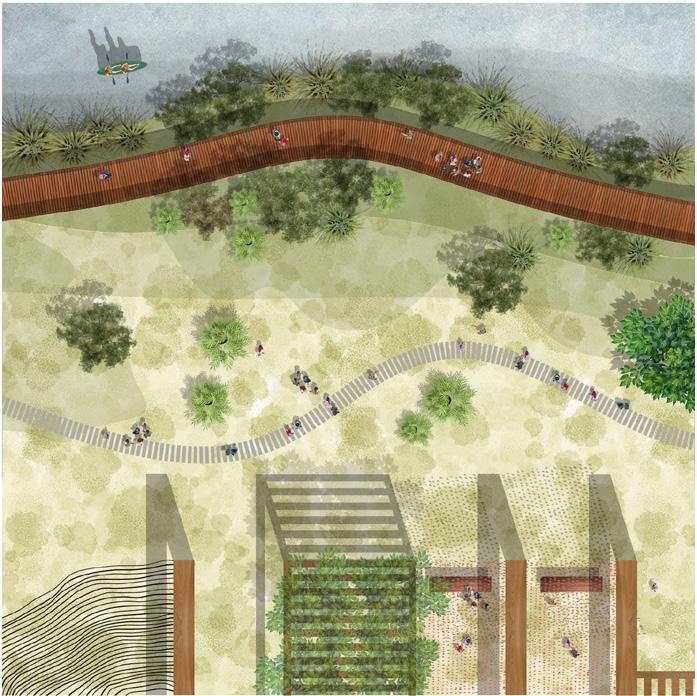
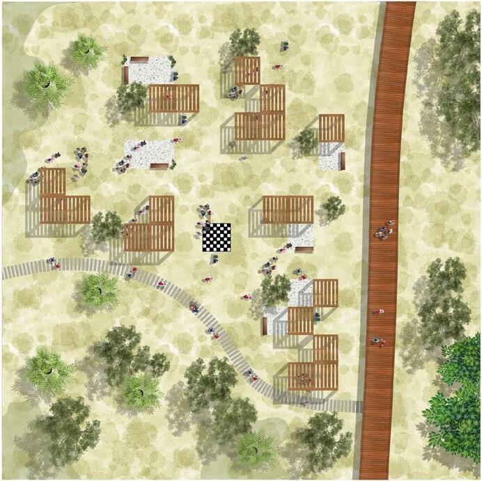
Zoomed in Design A - 1/200:
The site entrance is from the old building that was present on the site. The people will be able to experience the river on the wood deck elevated around 3m from the shoreline. The existing columns are used to frame the pathway experience of the pedestrians in the sanctuary. The design of the existing columns is made to imitate the Japanese gardens to give a sanctuary/ peaceful vibe to the site. The
patway runs along the borders of the natural topography present in the site. The design of the pathway becomes shy at the border of the bird sanctuary to not disturb the natural bird habitat. The pathway then rotate and reached the end at the parking lot. Poeple will be able to experience different parts of the santuary on one pathway. The material used as well are carefully chosen to not impact the identity.
39 URBAN DESIGN PROJECT 2022-2023
Figure 34
Figure 35. Zone A
URBAN DESIGN PROJECT 2022-2023
Figure 31. Master Plan
Zoomed in Design B - 1:200:
The East part of the Estuary is the Bird‹s habitat that will be protected. The seashore will host wooden stools for the birds to lay on. These stools will break the horizontally of the sea. People can use these spaces to sit and enjoy the sea, sunset, and the birds. The wooden deck in this area
is floating on the sand, which allows people to cross over freely.
People will be able to interact with the birds from the pathway. The pathway becomes on the surface of the sand in this area allowing more porosity from the site to the sea. The bird habitat won’t be distrubted by any borders, of dominant architecture.

41 URBAN DESIGN PROJECT 2022-2023
Figure 37. Site Plan.
Figure 36. 3D of this Section.
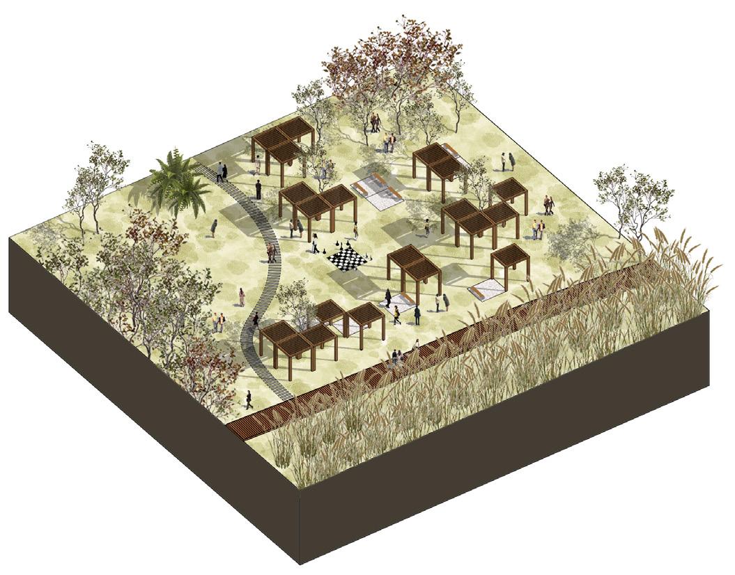
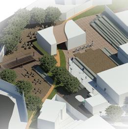
Zoomed in Design C - 1:200:
The pergolas are used for recreational areas. On occasion, these spaces can be used as markets and socializing spaces. People can also enjoy nature by sitting on the wooden benches and just relaxing. The wooden deck is also just floating on the ground to allow easy mobility around the site.
In conclusion, our design proposal seeks to transform the
Estuary of Beirut into a sustainable ecological sanctuary that preserves its natural beauty, supports diverse socio-spatial practices, and fosters a harmonious coexistence between humans and the environment. By implementing thoughtful design strategies and considering the various scales of intervention, we envision the Estuary becoming a destination that connects people with nature, enhances the overall well-being of the community, and contributes to the ecological revitalization of Beirut.

42 URBAN DESIGN PROJECT 2022-2023
Figure 39. Zoomed in design proposal.
Figure 38


 URDS601/ URDS601A: Urban and Landscape Design Studio
Open Space Network
Spring Semester 2022-2023
Instructors: Professors Howayda Al-Harithy and Jala Makhzoumi
TA: Batoul Yassine Students: Charbel Oueiss, Issam Raad, Joanna Daher, Mahmoud Bou Kanaan, Marwa Mansour, Neamah Chaarani, Omar Kaed Bay, Rana Khachab, Razan Elmrayed, Sara Hajj Hasan, Wiaam Haddad.
Iben Sarjoun Neighborhood Street Joanna Daher
Karantina Market Hub Charbel Oueiss
Scout’s Urban Park Razan Elmrayed Maritime Promenade Omar Kaed Bay Urban Balcony Rana Khachab
URDS601/ URDS601A: Urban and Landscape Design Studio
Open Space Network
Spring Semester 2022-2023
Instructors: Professors Howayda Al-Harithy and Jala Makhzoumi
TA: Batoul Yassine Students: Charbel Oueiss, Issam Raad, Joanna Daher, Mahmoud Bou Kanaan, Marwa Mansour, Neamah Chaarani, Omar Kaed Bay, Rana Khachab, Razan Elmrayed, Sara Hajj Hasan, Wiaam Haddad.
Iben Sarjoun Neighborhood Street Joanna Daher
Karantina Market Hub Charbel Oueiss
Scout’s Urban Park Razan Elmrayed Maritime Promenade Omar Kaed Bay Urban Balcony Rana Khachab
Bou
From
Community
Haven: A Sustainable Ecological Sanctuary for All Sara Hajj Hassan +
El
Issam Raad Sempiternal Pulse Wiaam
Urban
50m 100m 200m 350m 0 Complete Urban Proposal 43 URBAN DESIGN PROJECT 2022-2023
Rehban Active Spine Mahmoud
Kanaan
Dump to
Garden Marwa Mansour
Neamah
Chaarani
Haddad
Boulevard

ALL RIGHTS RESERVED
