T.T. Paterson’s contributions to Breckland Pleistocene geology in the 1930s; a tribute and commentary
by Richard West 3A Woollards Lane, Great Shelford, Cambridge CB22 5LZ
Summary T.T. Paterson’s records of Pleistocene sections in Breckland in the 1930s are examined, with a number of significant site records transcribed from his thesis, hitherto unpublished. Comments are given on the observations in relation to the way they improved our knowledge of the East Anglian Pleistocene and how they relate to the development of the subject. Further consideration is given to the history of investigations of the Skertchly Line of proglacial sands and gravels on the eastern and south-eastern margin of Fenland, and to the relation between geology and Palaeolithic archaeology.
Thomas T. Paterson (1909–1994) spent his late twenties and early thirties at the University of Cambridge, researching local sites of early Palaeolithic people’s activities. That at Barnham in Suffolk was published in 1937 and other Breckland sites were demonstrated at the British Association’s 1938 meeting at Cambridge. People in London could also see something of Paterson’s wider interests when in 1938 he gave a demonstration of Eskimo string figures on television. His work on a site at Elveden, Suffolk was published in 1940, but little more as the Second World War changed people’s lives, although he may have been able to use the 10 feet contour map made by the Geographical Section of the General Staff at the War Office. Paterson’s thesis has rested in the University Library since 1942 and I am delighted that Professor Richard West has ‘rescued’ (with comments) the Suffolk Geology part of it for us and for a wider audience. I also thank Martin Sanford and the Suffolk Naturalists’ Society for making this production possible (yet again!). I am pleased that Geosuffolk has been able to play a small part in this enterprise.
Bob Markham vii 2016
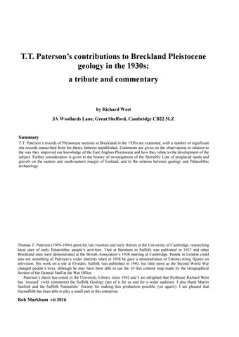
2
T.T. Paterson during the 1934 Wordie Arctic Expedition to West Greenland and Baffin Island. (Copyright Museum of Archaeology and Anthropology (University of Cambridge) Collection)
3
Summary 1. Introduction
4
2. Paterson’s map
6
3. The Elveden and Thetford-Santon Downham Districts
7
The Elveden District Site 20. Elveden Brickyard 24. Younghurst Wood 27. Elveden Gap The Thetford-Santon Downham District 29. Thetford Water-works and brickyard 30. Near 29 32. The Waterworks
4. The River Lark valley Site 51. Rats Hall 52. West Stow Brickyard 53. West Stow School 54, 55. In West Stow area 56. Beeches Pit 57. Devereux’s Brickyard 58. East of 57 59. Rampart Field Gravel Pit (Weatherhill Farm Pit) 60. Rampart Field Town Pit (Rampart Hill) 68. Tuddenham 69. Cavenham 70. The Cavenham alluvial cone The River Lark sites
5. The Mildenhall District. The Fen margin: Mildenhall to Brandon Site 71. High Lodge 72. Three Hills or Warren Hill 73. Mildenhall Brickyard 75. Chalk Hill (and Barton Hill) 76. Codson Hill 77. Portway Hill, Maidscross Hill 78. Gravelhill or Brandon Field
8 8 8 9 9 9 9
11 11 12 13 13 14 14 14 15 15 15 16 16 16
19 19 19 20 20 20 21 21
6. Paterson and the history of the Skertchly Line
22
7. The relation between sediments and Palaeolithic archaeology: a post-script
26
8. Concluding remarks
28
Acknowledgements
29
References 29
4
Introduction The Breckland of East Anglia, characterised by its sandy soils underlain by Chalk and gravel-filled valleys, is well -known not only for its flora and fauna, but also for its geology, archaeology and history of occupation. It is also a challenging area and has been the scene of much controversy in the fields of geology and archaeology. In the world of Palaeolithic archaeology this was the area in which questions about the age of man in relation to the Ice Age arose in the middle of the nineteenth century. Geological sections in Breckland, particularly in the Little Ouse and Lark valleys, provided evidence described by a number of pioneers in the field of the relation of archaeology to geology, including J.Prestwich, J.Evans, S.J.B.Skertchly, F.J.Bennett and W.Whitaker. At the same time the details of the Ice Age, such as the number of glaciations and the nature of interglacial periods between them was under much discussion, as were the processes which led to the deposition of such sediments as boulder clay (till), gravels and brickearths, now better known to be related to particular glacial, periglacial and interglacial environments. It was against this background that T.T.Paterson undertook research on Breckland geology and archaeology in the 1930s. His work had the great merit of being interdisciplinary, an early example of an approach now commonplace. T.T.Paterson’s Ph.D. thesis (Paterson 1942), entitled “Lower Palaeolithic Man in the Cambridge District” contains a wealth of information about a large number of sections in Breckland which he recorded with the aim of providing a stratigraphical background for the archaeology. His research was jointly supervised by M.C.Burkitt (archaeology) and O.T.Jones (geology), and he also acknowledged the instructive conversations he had with A.S.Watt, the doyen of Breckland botanists and pedologists. The dissertation is divided into a geological part, followed by a prehistory part and a summary. While the prehistory part, based mainly on excavations at Barnham and Elveden, Suffolk, was published in detail (Paterson 1937; Paterson & Fagg 1940), only a brief synthesis of the Pleistocene stratigraphy, based on his observations, was published (Paterson 1939), so that the detail of his geological work in his thesis has remained unpublished. T.T.Paterson’s son and executor, Dr E.T.Paterson, has kindly supported my aim to make his work more widely known, leading to the present account. Paterson set a good example. As his thesis shows, he understood the importance of regional geology underpinning archaeological investigations, though his interpretations were of the time. His observations, mostly of sections now long gone, are an invaluable record, made in detail and in relation to accurate position, height and relation to landscape. They reflect the increasing knowledge of sediments and sedimentary processes becoming available at the time, and are a distinct advance in investigations of Pleistocene deposits.
Paterson had been on expedition to Greenland and the Canadian Arctic (1934), so he had a significant background knowledge of cold climate processes. He applied this, for example, to interpreting periglacial processes evident in sections of terrace gravels in the Cambridge area, in terms of what he had seen in the Arctic (Paterson 1940), a pioneer work. The geology part of the dissertation consists of descriptions of a large number of sites and a synthesis of the stratigraphy. The Breckland is divided into two main regions, the valley of the Little Ouse and the valley of the River Lark. The Little Ouse area is divided into sections: the Honington-Fakenham district, the Barnham district, the Elveden district and the Thetford-Santon Downham district. The Lark area is divided into the Ingham district, the West Stow district, the Flempton-Tuddenham district and the Mildenhall district. Thus he covered the area thoroughly, much as the earlier surveyors of the Geological Survey had done many years before (Whitaker et al. 1891; Whitaker et al. 1893), and he included these older observations together with his own. The location of the sites examined is shown on a map of the physiography of the Breckland, with a contour interval of 10 feet (figure 1). Each numbered site has a six-figure grid reference (Cassini Grid (Square wM), O.S.Thetford Sheet, 1” map War Revision 1942) and usually a height O.D. attached. It would obviously be useful if the geology part of the dissertation, particularly the descriptive part, could be published in full. But, in lieu of this, two aspects of Paterson’s work call for comment. First, the physiographic map merits examination. Second, Paterson’s description of particularly significant sites needs to be made available to a wider audience. In choice of sites, I have chosen sites described in the Elveden, Thetford, West Stow and the Mildenhall districts, which areas have been the subject of much discussion in recent years. The sites are chosen in relation to three main topics: stratigraphy in chalkland areas (Elveden, Thetford), the geology of the Lark valley, and the geology of the Fenland margin sands and gravels between Mildenhall and Brandon. T.T.Paterson’s site descriptions are transcribed from the thesis, and are in italic. The one change I have made is the reversal of the list of sediment units in the sections described by Paterson. He gave them starting with the basal sediments, an arrangement which I found confusing, so the descriptions have been reversed and now start with the topmost sediments. The sites and long sections are numbered as on his map and in the text, and are given in my comments and elsewhere in brackets to distinguish them, e.g. [52]. After each site I have added comments on the significance of the sites and noted certain relevant observations concerning them. Many of the sections are particularly valuable in giving new information (e.g. West Stow Brickyard [52]), but I hope the selected sites will illustrate the purpose of bringing the whole to wider notice.
5 Table 1 gives an outline of the Pleistocene stratigraphy of Breckland, with estimates of ages and the relation between the geology and Palaeolithic sites. Stage
Approx. age Kyr
Flandrian (Holocene)
Potential occupation T
Palaeolithic sites occupation
Palaeolithic sites re-worked artefacts
*
———————————–——11—————————————————————————–———————-Devensian
P
*
Lynford
——————————–—–—115———————————————————–—————————————-Ipswichian
T
*
—————————————126-————————————————————————————————-P 160
*
L. Ouse valley gravels
G2
Skertchly Line gravels
Wolstonian
L. Ouse valley gravels P
*
High Lodge d
Redhill Bromehill
—————————————360-————————————————————————————————-Hoxnian
T
*
Elveden d E. Farm, Barnham d Beeches Pit d
—————————————430-————————————————————————————————-Anglian
G1
—————————————480-————————————————————————————————-pre–Anglian
T, P
T stable temperate (interglacial) conditions, forests P unstable periglacial/cool conditions; erosion, aggradation of river gravels, open vegetation or cool temperate forests G1 glaciation of East Anglia G2 glaciation of Fenland d doline site
6
2. Paterson’s map
Figure 1. Paterson’s map of the Breckland, showing the position of his sites and lines of connection between sites.
The map in the thesis (Figure 1) is valuable in showing a contour interval of 10 feet. The area covers areas of the Old Series Geological Memoirs of Sheets 65 and 51 NE. (Whitaker et al. 1891, 1893), at a scale of 2.1 cm to a mile. The sites described are numbered, with lines drawn to mark the positions, also numbered, of long sections which connect sites. The positions of the sites are given a six-figure Cassini Grid Reference in the text, after the title of the site. The map deserves a detailed comparison with the geological map. Here attention is drawn to some immediately evident features which the close contours reveal.
1. The map shows the line of isolated hills above the 100-foot (30.5m) contour at the eastern and south-eastern margins of the Fenland. These features relate to proglacial sand and gravels of the Skertchly Line described by Gibbard et al. (2009, 2012a,b), marking a margin of the Wolstonian Tottenhill glaciation of the Fenland, dated to c.160kyr. The hills are separated by valleys which increase in size to the north. 2. To the east of the line of isolated hills is a shallow valley, widening and deepening northwards. The valley separates the hills from the main Chalk escarpment, which rises to a plateau reaching c. 170 feet (52m) O.D.
7 There are exits from the valley to the west, between the isolated hills. The exit of the valley to the north is twofold. A wide western branch takes the valley northwest to a downstream part of the Little Ouse valley in Fenland. A narrower eastern branch takes the valley to an upstream part of the Little Ouse valley at Brandon. The course of these valleys suggests that they are related to the overflow history of a lake (Lake Paterson) impounded by the glaciation, which first drained eastwards to the North Sea via the Little Ouse and Waveney valleys (Gibbard et al. 2009; West 2007, 2009). The main north-south valley may be considered a meltwater valley, of the kind associated with the drainage of the Scandinavian ice-sheet in north Germany, described by Woldstedt (1955) (Urstromtäler). The narrower eastern branch at the north end of the north-south valley possibly formed at this time. With deglaciation, the marginal drainage systems must have evolved, the eastward direction replaced by a northerly system and a resumption of the Little Ouse catchment and drainage. The enlargement of the chalkland valleys appears to have been greater northwards, towards the Little Ouse valley, where drainage waters were strengthened by discharge from the lake impounded in the Little Ouse valley and from its catchment waters, but must have also been controlled by the position of the icemarginal accumulations described by Gibbard et al. (2009, 2012 a, b).
3. Paterson describes an alluvial fan at Cavenham [70], shown up clearly by the contours. It has suffered incision by the Lark, by the Tuddenham Mill Stream to the west and by the Cavenham Mill Stream to the east. Its size appears hardly compatible with a sole origin of sediment from the nearby Cavenham Mill Stream valley. It shows connection to neighbouring extensive gravelly areas, including to the south-west towards Kentford, along a valley now occupied by an under-fit stream, suggesting the presence here of marginal drainage of the Fenland ice-sheet in this area. Paterson connects the alluvial cone (delta) to an ice-marginal lake with an estimated height of 70 feet (21m) O.D. The cone appears opposite to the valley described above, indicating a possible connection between the two, with the valley a course of the overflow of Lake Paterson towards the Little Ouse valley. 4. The map suggests the presence of an abandoned valley across the chalkland plateau between Barnham and Lakenheath, via the Elveden area. This feature may be related to an original course of the Little Ouse River (with which it lines up) before it was captured by the Thet River. Such a capture was discussed by West (2009). The map shows clearly the abrupt northwards bend of the Little Ouse at Barnham, with the widening of the valley towards Thetford, before the river traverses the Little Ouse “gorge” towards Brandon.
3. The Elveden and Thetford-Santon Downham Districts The Breckland is characterised by the presence of meres and old brickpits. An excellent account of the meres was given by Bennett (1884). He considered that the meres are “confined to that portion of the district where the Chalk comes to the surface, or where it is only thinly covered by sand drift”. He suggested that the origin of certain meres lay in solution of the Chalk below, with changes in the water table in the Chalk encouraging solution, i.e. that they are dolines (sinkholes). As to the old brickpits, sections show the localised presence of inorganic sediments similarly occupying depressions in the Chalk. Paterson’s brickpit sites considered here are those near Elveden and Thetford which are described as showing the presence of brickearth or loams. Both these terms found much use in the past but do not meet today’s descriptive standards; essentially they are fine sediments, sometimes sorted or laminated, or of a more complex origin with varying components of sand, silt and clay, possibly combinations of loess and coversand. Readers of the Old Series Geological Memoirs relating to Breckland (e.g. Whitaker et al. 1891, 1893) will be struck by the number of pits in the chalkland from which brickearth and loam has been won for manufacture of bricks, tiles, etc. The fact that these exposures are local and do not define a specific widespread mantle must be related to their origin. They are a speciality of
the Breckland chalkland and their localisation must result from deposition in dolines over particular periods of time in the Quaternary. In respect of this, it is notable that site descriptions of Palaeolithic archaeological interest have often spoken of channels in the Chalk containing sediments (including brickearth and loam (e.g. Elveden [20], East Farm, Barnham [7], Beeches Pit [56]), yet there is no evidence for the drainage systems or rivers related to the channels, and they appear better interpreted as sites of dolines. The infilling sediment of these dolines contributes to the record of environmental conditions during the time of doline infill. Looking at the Breckland nowadays, the well-known meres, described for example, by F.J. Bennett (1884) and Clarke (1924, 1925), are an expression of doline formation. Some contain postglacial organic deposits, indicating maintained water levels (e.g. Hockham Mere, with a record of c. 10000 years of post-glacial vegetation history; see K.D. Bennett (1986)), others can have dry beds, occasionally or often flooded, with an inorganic infill (e.g. Ringmere, Langmere). Then there are sites of archaeological importance associated with other dolines, with an infill indicating a temperate Hoxnian interglacial age, e.g. Elveden [20] and Beeches Pit [56]. Evidently dolines form at different times, and their fill reflects conditions at time. The brickearth pits contain evidence of fill of clays,
8
Figure 2. Skertchly’s section at Elveden Gap Brickyard, site [27], taken through the centre of the pit. Redrawn from the figure in Whitaker et al. (1891). Scale on right (43 ft,13m) indicates total thickness of sediment. Key: feet a. Sand and gravel 6 b. Dark blue, tough boulder clay, full of scratched stones 3 c. Grey clay 4 d. Blue clay 12 e. Rock. Consolidated loam, coherent enough to form a Glacial roof, beneath which the loam is tunnelled for a short distance 0-2 Drift f. Buff laminated loam 4 g. Loam (as above) and gravel 4 h. Loam (as above) 4 i. Chalky clay, not seen, but described as like the top bed of Boulder Clay 2 j. Gravel, not seen (reached by boring) 2
loams and diamictons at times when organic sediments could not form or survive, so that sequences within them may well be informative of non-temperate conditions. The stratigraphy of inorganic doline fills has not been investigated or described in any detail recently, and any description of them, such as those of Paterson and the Old Series Memoirs, are therefore significant. They are waiting to be interpreted in detail. Comments on each site or sediment are added to the extracts from Paterson’s descriptions and notes, which are in italics.
The Elveden District 20. Elveden Brickyard. A section has been excavated in the brickyard, 264989, 1200 yards N.N.W. of Elveden cross roads, and has already been described by the author (Paterson, T,T. and Fagg, B.E.B. Proc. Prehist. Soc. 1940). The surface lies at 145 feet O.D. Paterson & Fagg (1940) described the geology and archaeology of this site. They considered that the fine sediments recorded were related to a buried river channel. Further details of the geology are given in Paterson’s thesis, sites [20], [21]. The sections here and their archaeology have been thoroughly investigated recently by Ashton et al. (2005), with a re-intepretation which identifies fine sediments correlated with the Hoxnian interglacial stage, lying in a hollow in the Chalk, and associated with a channel. Important points made in the recent investigation are that the “Pleistocene sediments lie in a depression in the Chalk bedrock” and the interpretation of the uppermost sediments as the product of colluvial processes, together with cover sand with involutions. Turner (1973) wrote a brief note on the brickpit, observing a section showing a series of stratified sediments banked against a sloping cliff of
chalky boulder clay and commented that a doline origin of the sequence was a possibility. The same near vertical plunge of Chalk was recorded by Paterson & Fagg (1940, Figure 2). A doline explanation fits these observations. This is an important site when considering the vexed question of an upper boulder clay (till) in Breckland. Paterson described the uppermost horizon (his bed J), after discussion with A.S.Watt, as a decalcified remnant of a boulder clay. Ashton et al. (2005) described their topmost bed (bed 6) and considered it a cover sand and associated involutions, associated with periglacial conditions, a convincing conclusion. The difference reflects the increased knowledge of periglacial matters since Paterson’s time. It is interesting to note that Skertchly also interpreted near surface horizons in Breckland as an upper boulder clay, as figured in Geikie (1877, figure 57; 1894, figure 67). 24. Younghurst Wood. 257972. About ½ mile S.W. from the crossroads a pit on the north side of the Mildenhall Road shows brown loam under sand, the equivalent of the leached boulder clay at the brickyard. In the Sheet Memoir, (1891, p.54) F.J.Bennett notes that 20 feet of loam lies in a hollow in (sic; of) boulder clay at this point. Comment: Interpretation of the uppermost sediment as a leached boulder clay is problematical. Here the loam is described as lying in a hollow of boulder clay. This may be a diamicton derived from collapse into the doline, as recorded elsewhere. 27. Elveden Gap, 295995. One and three quarter miles N.E. and by E. of the cross roads, and 170 yards from the Thetford road on the south side is an old brick kiln and pit. The pit is now overgrown and only the upper layer, boulder clay, of the
9 following section (Sheet Memoir, 1891, p.54, fig.7) could be tapped by light digging. (g) Twenty-two feet of bluish brown boulder clay, with “4 feet of grey clay and 12 feet of blue making up the lower portion”. This clay carries brown loam and Bunter pebbles. (solifluction into doline ?) (f) Up to 2 feet of (e) hardened so much so that it is “coherent enough to form a roof, beneath which the loam is tunnelled for a short distance”. (cementation) (e) Loam like (c), 4 feet. (as (c)) (d) Similar loam but gravelly, 4 feet. (solifluction into doline ?) (c) Buff laminated loam, 4 feet. (stratified) (b) Chalky boulder clay, dark blue, 2 feet, “like the top bed”. (solifluction into doline) (a) Gravel down to 2 feet, bottom not proved. The Sheet Memoir also notes that the lower of the boulder clays in a pit 200 yards from the road on the north side is “light-coloured”. Chalk comes to the surface close by in several directions and the conclusion of the authors of the Memoir is that these beds are troughed in a hollow (pothole) of the chalk. It is suggested that “many tiny faults in the loam” (recorded in the Memoir) are due to gradual sinking owing to the solution of the chalk below. From the character of the similar loam, 20(j) (the near surface sediments) at Elveden brickyard, these faults might possibly be due to ice load. Comment: Skertchly’s drawing of the section (figure 2) and his description (Whitaker et al. 1891) show that only the top 6 feet is boulder clay. Bed b of Paterson is described by Skertchly (bed i) as “chalky clay, not seen, but described as like the top boulder clay”. Possible interpretation of the fill of the doline is given in brackets above. Skertchly described his section (figure 2) as follows: “The beds lie in a pot-hole, which has most likely been formed by the gradual solution of the chalk beneath. It is clear that the beds have not lost their relative positions, and the effect of the gradual sinking is shown by the occurrence of many tiny faults in the loam.” The variety of the sediments in the pot-hole, with a horizon which has undergone cementation, must reflect environmental changes in the area. There is the possibility of both lacustrine and aeolian contributions to the sequence. Skertchly has further interesting comments on the nature of the brickearth in the area, with differing content of clay and sand. Obviously a detailed investigation is required.of the loams and their sedimentology and structures. Such could provide an invaluable record of regional periglacial history. The sections around Elveden therefore have certain points in common. Pits 20 (Elveden Brickyard),24 (Younghurst Wood) and 27 (Elveden Gap) show loam and sandy loam lying between two boulder clays, and in all three the upper boulder clay has been found to carry loam and Bunter pebbles. In 20 the lower one does the same and in a pit near 27 the lower is “light-coloured”. It is not too daring to assume that these pits show essentially parallel sections. All three loam deposits are
laid down in hollows or channels, which have been cut out of the chalk prior to the deposition of the lower of the boulder clays. The gravelly loam 27(d) at Elveden Gap appears to be the equivalent of the layers 20 (f,g,h) at the Brickyard. Comment: Significant points here show Paterson recognised the possibility of dolines as significant features in Breckland, with a diamicton recorded as lining the hollows. But there was always the problem of interpreting the “upper boulder clay”, which formed the third and latest boulder clay of Paterson’s sequence. The possibility of channels in the Chalk is mentioned, but not substantiated.
The Thetford-Santon Downham District Paterson describes a number of sites in this area. They are also included in Skertchly’s long section in Whitaker et al. (1891), which is then considered. This long section is reproduced in figure 3. 29. Thetford Water-works and brickyard, 321028. Fourteen hundred yards north of the bridge at Thetford a disused pit, formerly worked for brickearth, still shows some brown loam overlain by sand. However, during working it was dug to 35 feet and showed the following, (1891, p.59):(d) Sand and gravel, no bedding, deep red brown in colour, with angular flints and many Bunter pebbles up to 10 feet. (solifluction on the slope) (c) Dark bluish grey laminated clay, up to 12 feet. (stratified) (b) Buff loam, up to 16 feet. (a) boulder clay (presumably light coloured as in the next section 200 yards away) up to 7 feet, on chalk. Comment: this sequence shows a basal diamicton on Chalk, with a variation in the fill from stratified laminated clay to loam, pointing to change of conditions in the doline basin. 30. Across the road, 200 yards west of 29 at 318029, another pit dug for brickearth showed a similar section (1891, p.59, fig.11). (e) Sand and gravel as in 29 (d), up to 7 feet. (solifluction on the slope) (d) Buff laminated loam, up to 7 feet. (stratified) (c) Bluish grey clay, laminated towards the base, and seeming to pass into the (b), 3 to 7 feet. (stratified) (b) Buff laminated loam, about a foot (stratified) (a) Light coloured boulder clay, up to 10 feet on chalk. Comment: The sequence here shows stratified sediments, loam to clay to loam, sealed by sand and gravel on the slope. 32. The Waterworks, 319030. (d) Sand and gravel, and brown boulder clay, up to 10 feet. This boulder clay is at present exposed on the west side of the road. It is much decalcified but still very definitely recognisable as a boulder clay. It carries many Bunter erratics. (c) Buff loam, 6 to 7 feet.
10 (b) Blue clay, up to 13 feet, sometimes on chalk, (1891, p.60). (a) Boulder clay resting on chalk at a depth of 60 ft. (Hughes, T. McKenny, Journ. Roy. Anthr. Inst., 1878, vol. VII, p.163.) (boulder clay proved to a depth of 60 feet) Comment: The sequence shows clay overlain by loam, as at other sections. The uppermost sediment is interpreted as a till, much decalcified. There are several other pits in the near neighbourhood which conform to the sequence shown in the three sections above. (cf. 1891, p.60). In the Sheet Memoir, (1891, p.59), Skertchly is positive that the unbedded sand and gravel forming the top layer at 29 and 30 is boulder clay and says, “trial holes have been made over a considerable area, for the purpose of finding the loam, and in every instance this, as well as the underlying boulder clay, was found to thin out, as the Boulder clay thickened upon it higher up the hill”. This thickening, as shown by his section based on trial holes and theodolite reckoning (1891, fig.10), and adapted here to the generalised section figure 34, is a matter of one to three feet. The sand and gravel has the appearance of leached boulder clay which is so common in the heathland to the west of Thetford, and the origin of which Dr Watt has demonstrated. The fairly uniform thickness of this upper gravelly sand over the slope towards the river (as well as the absence of bedding) is further support of this conclusion. It is hardly possible that fluviatile sands and gravels could be so distributed, but it is quite the configuration to be expected of a leached boulder clay which clothed the hillsides and hill-top. Moreover Skertchly (1891, p.59) points out that the laminated loam is disturbed. The disturbance is comparable to that of the loams at Elveden and probably due to the same cause pressure of ice above. Finally, the actual presence of brown boulder clay on the surface at the Waterworks associated with the sand and gravel, is complete proof of Skertchly’s supposition. Comment: This is an interesting comment concerning the origin of near surface sediments in the Breckland. Paterson supports Skertchly’s interpretation, but the argument that uniform thickness of the overlying sands and gravels is quite the configuration to be expected of a leached till may give way today to an argument that it is a leached product of solifluction of gravels (glacigenic or fluviatile) which mantles the area. Key: a. Sand and gravel : Glacial b. Blue clay Drift c. Buff loam d. Boulder Clay e. Chalk Distance along the base line marked in chains Figures marking vertical lines are heights in feet above datum Figure 3. Skertchly’s section at Thetford uphill along the road from the railway to the Waterworks (a N.N.W. direction). Redrawn from the figure in Whitaker et al. (1891).
11 Figure 3 is a redrawn version of Skertchly’s levelled section upslope (c. 100 to 150 feet (30-46m) O.D) along the road from the railway to the Waterworks (figure 10 of the Old Series Memoir (Whitaker et al.1891). Skertchly describes the general section in detail in the Memoir: “From the Waterworks southward to the brickyard I saw a continuous section, given by the well and the excavations for cisterns, by the trenches in which the pipes were laid, by an old pit, and by the brickyard close by. Beside these I obtained details of all the pits and trial-holes that had been made by the brickmakers during the previous twenty years. The accompanying general section (fig. 10) has been made with great care from the levels taken by the theodolite, and from the information noted above.” The section shows clearly the position of loams and clays within depressions in the Chalk, which have the appearance of dolines. It is interesting to note that a similar depression in the Chalk, discovered by ground penetrating radar and interpreted as an infilled solution hollow in the Chalk, has been described by Gibbard et al.
(2008) on the north bank slope of the Little Ouse River at Redhill, c.2km downstream from Thetford, and that on the south bank of the river, a possible solution depression associated with fine sediments has been described at Santon Downham, a short distance further downstream (West 2009). The presence of stratified sediments in the sequences noted above, including clay and loam indicates the possibility of local bodies of standing water in the dolines receiving fine sediments, with coarser silty and sandy sediments replacing them from time to time. The interest of Skertchly’s section at Thetford is that it shows variation in the fill of the depressions (basal till or loam on Chalk) in a particular small area on a slope of the Little Ouse valley. Other Breckland sites show similar sequences. There is likely to be a regional significance of these variations (such as times related to aerial dispersal of sands (cover sand) or loess. Skertchly’s long section and Paterson’s descriptions help to bring to light the variation of sedimentation in the dolines.
4. The River Lark valley The River Lark valley is remarkable in the richness of its Quaternary record. A great variety of sediments is recorded in the Icklingham to West Stow stretch of the east bank of the river. The area is one of low terrace features banked against a slope rising to the Chalk and Anglian till plateau to the east. Many sand and gravel pits have been described from the slopes, showing variety of sedimentary environments and there are also brick pits with clay and loam and doline fill sediments. This section of the valley is also associated with finds of Palaeolithic artefacts, going back to the 1860s when such finds were first stimulating the discussion of the relation of Palaeolithic man to the glaciations of the Ice Age. Paterson described many sections from here which form an invaluable record, which he summarised summarised in the long section [62], located on the map. The West Stow District The sections in this district described below lie along the east bank of the river N.W. from West Stow towards Icklingham. In this region several deep pits have been worked for the same kind of brickearth, and the various exposures as well as those noted in the Sheet Memoir or proved by auger, demonstrate a constant succession. 51. Rats Hall, 284898. A pit at 105 feet O.D. has been worked for gravel to a depth of 12 feet, on the south side of the West Stow – Ingham road about 100 yards from Rats Hall and 500 yards S.W. across the valley from the pit at Limestone Plantation, 44. (d) Fine angular, white-patinated gravel with signs of fossil polygonal structures and solifluxion. (c) A level like (a) but much distorted by some disturbing process. (b) A thick mass of brown boulder clay with Bunter erratics.
(a) Very coarse, unbedded gravel conglomerate carrying masses of sand, lumps of clay, (also interstitially), large fragments of chalk, not waterworn, and many Bunter erratics The three lower deposits can be indubitably classed as boulder clay. Comment: This section (figure 4) shows a tongue of diamicton overlying coarse chalky gravels, cut out by overlying much distorted gravel, and an uppermost horizon of finer weathered gravel with “signs of fossil polygonal structures and solifluxion”. Rather than considering the lower deposits as boulder clay, the details given suggest that beds b and c are products of solifluction, with bed b, a diamicton, cut out by a gravel which has undergone distortion by slope processes and possibly involution. This is an important section at c.32m O.D. on the down-slope of a ridge extending from the plateau to the east, which rises to over 35m O.D. The section at the West Stow Brickyard [52] is c.350m to the west and lies on the same slope. The position of these sites is shown on the map, figure 1.
Figure 4. Paterson’s section at Rats Hall, site [51]. Key (see text for detail): d. White-patinated gravel c. Like (a) but much distorted b. Brown boulder clay a. Coarse gravel-conglomerate
12
Figure 5. Paterson’s section at West Stow Brickyard, site [52] (Culford). Key (see text for detail): g. Brown boulder clay f. Involutions involving d and e e. Coarsely bedded, foreset, chalky sand up to 2 feet d. Very fine stratifed sands and silts c. Pale brown yellow loam, clayey and sticky, no stratification b. In a trench in the pit, stratified harder loam, seams of sand, carbonaceous markings a. Brown boulder clay, plunging abruptly below b and c
52. West Stow Brickyard, 278897. A fine section is exposed at 110 feet O.D., in the yard of the brickworks ½ mile N.E. of West Stow Church. The same pit is referred to in the Sheet Memoir, 1891, p.51, as Culford Brickyard. In the Memoir the following information is given. Feet Sand and gravel 0-9 Boulder Clay 0-2 Buff laminated loam 15 Harder loam with seams of sand and carbonaceous markings 15 Cemented gravel, thin Chalk From the diagram, (fig.5, p,51), accompanying these details it seems that the chalk must lie at about 70 feet O.D. Quoting further, “the loams which dip south west at a slight angle have been planed off by the Boulder Clay and in places are finely contorted ((cf. Devereux’s brickyard, 57)). At first sight it would seem that the clay rested evenly on the loam but …the above mentioned points… (give) proof of the influence of pressure, for the top part of the loam has been converted into a hard mass, the laminae of which are parallel to the Boulder Clay and not to the loam beneath”. Freshwater shells, fragments of wood, and a worked flake (from the loam) have been found, the genuine ‘human’ character of the flake being corroborated by two other observers. A cast in the Sedgwick Museum shows that this flake is waste from manufacture of a biface. The Rev. O. Fisher adds information at a later date, that “the Boulder Clay at the eastern end of the pit was nearly worked away and had degenerated into a sandy gravel”. This last remark adds strong support to the assumption that the sand capping at Ingham (section 50) is the equivalent of this upper boulder clay overlying the yellow sandy clay of the “Cadogan Arms” bore which clay is equated with the loams of the brickyard.
In the years 1936-38 the sections exposed showed a somewhat different sequence. The northern end of the eastward face was entirely made up of boulder clay but the loam appeared at the southern end. Traced northward the loam and the upper sandy parts were seem to thin out and pass laterally as a thin tongue into the boulder clay. Along the level of this tongue occasional seams of loam and sand could be traced, mixed up with a very chalky level of boulder clay It seems therefore that two brown boulder clays are involved, the loam being laid down in a hollow in the lower and the chalky layer marking the base of the upper. This chalky basal portion is what one might expect in the bottom moraine of an ice sheet passing over a predominantly chalky outcrop. The two boulder clays cannot be distinguished by eye except for this layer. (g) Brown boulder clay with Bunter erratics and a basal chalky layer. In parts it has the appearance of banding suggesting it was laid down in water. (f) The pressure of the later ice has forced (d) and (e) down into the loam, squeezing it out in fine irregular seams just as if it had been injected into the silts and sands. Further pressure has warped, “folded” and “thrust” these seams of loam. This phenomenon merits separate treatment elsewhere. (e) Towards the south end of the face up to 2 feet of coarsely bedded, foreset, chalky sand overlies both (c) and (d). The junction seems to be erosional. There are many layers with carbonaceous material scattered along them, and in places charcoal is concentrated in horizontal circular patches. Occasional bands of very fine, laminated, cream-coloured silt have been observed among these sands during the working of the pit face. This level, though thin, is strongly reminiscent of the current-bedded, charcoal-bearing, chalky sands of pit 16 at Barnham. (d) Very fine stratified sands and silts. This deposit overlaps the loam and is the part seen to finger out
13 between the boulder clays In places it has been tilted upwards by the advancing later ice sheet. (c) Pale brown yellow loam, very sticky and clayey in the hands with no apparent stratification of any kind. (b) In a trench in the middle of the present pit the “harder loam(s) with seams of sand and carbonaceous markings” is exposed. It is stratified, and the seams are warped, probably due to the pressure of the later ice sheet which has contorted the upper beds. (a) Brown boulder clay, with Bunter erratics, plunging abruptly below (b) and (c). Comment: Paterson’s drawing of the section is shown in figure 5. This brickyard is where Skertchly discovered a worked flake in the stratified loam below a diamicton interpreted as till. He was accompanied by F.J. Bennett, and the visit put to rest Fisher’s doubts about the age of man (Fisher 1880). The section is interesting in many respects: (i) The possibility of occupation horizons in bed e shown by “charcoal concentrated in horizontal circular patches”, a similar situation to that observed in Beeches Pit (Preece et al. 2006, 2007). (ii) The “plunging abruptly” of the lower diamicton below stratified sediments (Skertchly’s description of the section in the Old Series Memoir (Whitaker et al. 1891) describes the loam as overlying the Chalk with no lower diamicton). (iii) The deformation of stratified sediments below the upper diamicton. (iv) The thinning-out of the loam and upper sandy sediments to the north between the two tills. The calcification of horizons in the loam may indicate pedogenic processes active during or post-dating the time of deposition of the sediments. Are the sediments the fill of a doline, the silts and sands being pool deposits in such a situation ? Banding in the upper diamicton is of interest since there is the possibility of a proglacial lake in the Lark valley at the time. The top of the section is at c.33.5m O.D. The level of the upper diamicton is similar to the disturbed sediments and diamicton at Rats Hall [51], described above, c.350m to the east. Both sites are on the slope of a ridge of the plateau to the east, as described above. 53. School, 274893. At the road junction in the village of West Stow, below the school a pit from 85 feet O.D. has been worked for sand and gravel since before 1936. In that year it was 30 feet deep the lower 20 feet being composed of bedded (fluviatile) gravels and sands, somewhat loose, with many Bunter erratics. The upper 10 feet was made up of iron-stained unbedded gravel and sand, the elements upended and not water-laid, with many angular flints and Bunter erratics. It was interpreted as leached boulder clay. In 1938 the section had changed though the pit had only been worked back a few yards. (e) Leached boulder clay up to 6 feet. (d) In a pocket 12 feet deep, finely bedded yellow sand with clay bands.
Figure 6. Paterson’s section at West Stow, near the school, site [53]. Key (see text for detail): e. Leached boulder clay up to 6 feet d. In a pocket 12 feet deep, finely bedded yellow sand with clay bands c. Well-bedded fluviatile gravels and sands, very little chalk b. Loose current-bedded chalky sand and gravel a. Heavy conglomerate made up of chalk and flint boulders, in a sump which reached chalk
(c) Well-bedded fluviatile gravels and sands with many Bunter pebbles but very little chalk (b) Loose current-bedded, chalky sand and gravel. (a) Heavy conglomerate made up of chalk and flint boulders with some Bunter erratics. This material was in a sump which reached chalk. The information was obtained from the workmen and the material was seen pile up on one side of the pit. An Acheulian biface was said to have been found in this layer but it could not be traced. Comment: Paterson’s drawing of the section is shown in figure 6. The basal sediment is similar to that at site [51], a coarse conglomerate and flint boulders but at a much lower level (c.18m O.D) and reported to be resting on Chalk. Bed c, fluviatile gravels with little chalk, is at a similar level (c.21m O.D.) to the gravels at Rampart Field Gravel Pit (Weatherhill Farm pit) site [59], but those contain “a great quantity of chalk pebbles”. Possibly they are part of the same gravel train up the valley. The uppermost bed, “iron-stained unbedded gravel and sand, with elements upended and not waterlaid, with many angular flints and Bunter erratics” is interpreted as a leached boulder clay, but seems more likely to be a superficial sand and gravel affected by cryoturbation, and, since it is on a valley slope and at a lower level than the West Stow Brickyard [52], a product of solifluction. 54. Across the road N.W. from the brickyard 52, at point 273898, ½ mile N. of West Stow Church, a pit from a height of 90 feet O.D. used to show a section similar to that of the brickyard,(1891, p.52.). (d) “Brown stony boulder clay, with chalk pebbles. At one part all the chalk has been dissolved out, and there are sand galls; the division between this and the chalky clay was sharply marked and nearly vertical”, (presumably leaching in pipes); 6½ feet. (c) “Thin layer of chocolate-coloured clean clay”. (b)”Pinkish brown clayey sand, weathering greenish, and having a marked even junction with the clay above (it);1½ feet”. (a) “Finely laminated brown sandy loam; 6 inches”.
14 Comment: Partly weathered diamicton, possibly underlain by a Bt soil horizon of clay, overlies loamy sand and clayey sand. A comparison is made with the West Stow Brickyard [52]. 55. The Sheet Memoir (1891, p.52) also notes in an old pit in a field, 267903, about ¾ mile N.N.W. of West Stow Church , “a capping of stiff reddish clay with a few flints, which may be weathered. Boulder clay (sic; weathered Boulder Clay), over very finely bedded buff loam”, in which a leaf impression was found. The weathered boulder clay lies here at 88 feet O.D. and can be traced to a level of 10 feet below in a shallow pit at point 268900 close to the keeper’s lodge north of West Stow Hall. Comment: diamicton over loam, as recorded elsewhere. 56. Beeches Pit, 252905. The geology and archaeology of this site has been thoroughly studied in recent years (Preece et al. 2006, 2007), but it is instructive to compare the old descriptions (e.g Skertchly in the Sheet Memoir (Whitaker et al.1891, figure 18, p.79) with the recent results. The old descriptions recognize a series of loams, fossiliferous and with palaeolithic artifacts overlying boulder clay and underlying further boulder clay, partly leached. Paterson describes Skertchly’s succession, and checked on the sequence with the auger. The recent investigations give evidence of the presence of a doline in the Chalk, with a diamicton at the base derived from a till, followed by a varied filling of fine sediments. These are overlain by a complex diamict (clayey gravel), decalcified in part, and associated with involutions and solifluction. This is Bed 8 of Preece et al. (2007), where it is described in detail, and may include what Skertchly drew as an upper boulder clay. His drawing has some similarity with the section at West Stow Brickyard [52], with two diamictons separated by loams, a similarity noted by Paterson in his section on Beeches Pit. The description by Preece et al. 2006, 2007) of the sediments containing evidence of human activity and fire (e.g. charcoal, burnt flints) is of particular interest. Limited areas (c. 1m2) showing this evidence are interpreted as hearths, illustrated in figure 4 of Preece et al. (2006). At West Stow Brickyard, Paterson’s site [52] (see description above), bed (e) (coarsely bedded, foreset, chalky sand) is described: “There are many layers with specks of carbonaceous material scattered along them, and in places charcoal is concentrated in horizontal circular patches. Occasional bands of very fine laminated, cream-coloured silt have been observed among these sands during the working of the pit face”. It seems likely that the circular patches noted at West Stow Brickyard may also be hearths. A further similarity with West Stow Brickyard is that Skertchly (Whitaker et al.1891) recorded freshwater shells, fragments of wood and a worked flake from the loam with carbonaceous markings at the Brickyard. 57. Devereux’s Brickyard, 247906.
This brickyard and brickearth pit, long disused, still shows traces of the sections described by Skertchly, (1891, p.79). It lies 500 yards W. of Beeches pit, and 850 yards E, of Weatherhill Farm. Loam has been excavated to a depth of 15 feet, and at the well in the brickworks close by it is 30 feet thick resting directly on chalk, (1891, p.114). (c) Gravelly sand, leached boulder clay, depth to 3 feet, at 105 feet O.D. (b) Brown, with reddish-brown, sandy loam. In places it must have been, during Skertchly’s investigations, a very fine clayey silt for he refers to it as “dirty brown loesslike loam”. There are a few scattered flints and also pebble seams. Plant seeds, Bulimus and Pupa have been found, and Skerchly mentioned freshwater shells as well as “bones and deer-horns”. He notes also obscure laminations near the top, the loam being bedded below, dipping westward at 2o; to 10 feet. (a) Light grey clay, with carbonaceous matter, and a top layer of three inches of darker grey clay; to 2 feet. Comment: The brickyard is labelled a Chalk pit in the 1884 O.S. 6” map. The map shows the position of a well in the brickyard to the east of the pit. The well record in the Memoir (Whitaker et al. 1891) shows 30 feet of loam overlying 30 feet of Chalk. Skertchly, in the Memoir, recorded two sections at the Brickyard. A section at the east end of the pit showed: Gravelly soil, say 2 feet. Reddish loam, obscurely laminated above, more evenly bedded below, with a few shells or flints, 8 feet. Darker, brown, clayey loam, 2 feet. Dark grey clay 3 inches. Light grey clay, with black specks, seen to 2 feet. At the west end of the pit was a further section: Gravelly soil, say 2 feet. Dirty brown loess-like loam, with a few small flints and some thin seams of sand; three bands of race, with a few flints in the uppermost, 5 feet down in the loam, 6 feet 2 inches, and 6 feet 11 inches. Seen to over 10 feet. Lewis (1998) described finding a sequence of grey calcareous clays, partly shelly, in the pit. These were proved to a depth greater than 7m, and were decalcified in the upper part. There must be a very steep contact between the Chalk and the brickearth, with Chalk near surface to the north of the pit, where there is striped patterned ground, suggesting the possibility that the brickearth lies in a doline. Wymer (1985) and Lewis (1998) note artifacts possibly related to this site. This is clearly an important site, meriting further investigation. 58. At about 100 yards east of Devereux’s brickyard, across the track serving it, a pit shows a different sequence. In the Sheet Memoir, (1891, p.80) it is described as a gravel pit with a section 20 feet deep “in these gravels and loams”. In the present condition only the upper part of the section can be seen and it is made up of fine current-bedded chalky sand, rather loose, with bands of gravel. Presumably
15
Figure 7. Paterson’s section at Rampart Field Gravel Pit (Weatherhill Farm Pit), site [59]. Key (see text for detail): d. Pale brown boulder clay, exhibiting all stages of decalcification to its brown gravelly sand equivalent c. Lenses of finely laminated, cream-coloured, clayey silt near the top are warped and distorted b. Lenses of current bedded sand with specks of carbonaceous material a. A series, nearly 20 feet thick, of very coarse, strongly current-bedded gravel, carrying a great quantity of chalk pebbles and also many Bunter erratics
the loams lie below and therefore these sands and gravels must be laid down in a channel cut out of the former. Comment: any loams are possibly an extension of those of Devereux’s Brickyard [57] to the west. 59. Rampart Field Gravel Pit, 245905. (Weatherhill Farm Pit) West from Devereux’s brickyard the ground slopes down into a shallow valley on the east side of which, at a distance of 200 yards from the brickyard, a pit has been dug for gravel. The ground between was sounded by auger and the gravel in this pit was found to lie banked up against the loams, a relationship similar to that in section 58. (d) The disturbance is no doubt due to the action of ice which has left pale brown boulder clay in small patches especially on the northern face. There is much erratic chalk and many Bunter pebbles in this clay which exhibits all stages of decalcification to its brown gravelly sand equivalent. (c). Lenses of finely laminated, cream-coloured, clayey silt near the top are warped and distorted, the disturbance increasing rapidly in the upper beds of the gravels and sands until all signs of stratification are lost. (b) There are several lenses of current bedded sand with specks of carbonaceous material. (a) A series, nearly 20 feet thick, of very coarse, strongly current-bedded gravel, carrying a great quantity of chalk pebbles and also many Bunter erratics. Comment: Paterson’s drawing of this section is shown in figure 7. These gravels are at a level similar to those upstream at West Stow School [53]. The note on the local landscape and the relation to Devereux’s Brickyard (above) is useful. The description compares well with the description of this site by Bridgland et al. (1995), which includes the significant observation of an easterly palaeoflow direction for the sands and gravels (upstream in the valley). The “great quantity of chalk pebbles” indicates active erosion of Chalk in the area at the time. 60. Rampart Field Town Pit, 242902. (Rampart Hill)
Five hundred yards in a S.W. direction from the Gravel Pit, 59, a small hillock overlooks the flats of Letch Moor which forms the 10 foot terrace. Several pits have been dug into the hillock which is apparently made up of one series of exceedingly loose, coarsely current-bedded, and sometimes steeply foreset, chalky gravels and sands with sub-angular sand grains and very many Bunter pebbles. Evans (“The Ancient Stone Implements etc,” 1872, p.488) records the finding of flint artifacts here but they can no longer be traced. He also adds that “teeth and portions of tusk of Elelphas primigenius have been found”. Viewed from the road junction nearby these outwash deposits, despite the disturbance by human activities, exhibit fresh topographic features. The sides of the hillock are irregular and hummocky contrasting with the smoother outlines of the escarpment of the higher Beeches Pit terrace farther back from the river. There can be no doubting that this outwash is banked up against the earlier deposits of that terrace. The Geological Survey, Sheet 51,N.E., shows boulder clay to the north of the hillock top, that is, farther back from the river, but owing to the widespread decalcification of this boulder clay it was found impossible, from a surface traverse, to determine if it overlay the outwash. The boulder clay seems to be continuous with that at the top of section 59, where the outwash is of a different character to the very loose Town pit material. A much finer section in outwash, similar to the latter at Three Hills (to be described later) suggests that both have been laid down under water accounting for the steepness of the fore-setting as well as their looseness. The outwash in section 59 has been deposited subaerially. Comment: This description is of significance in comparing the loose, steeply foreset chalky gravels with those found at Barton Hill [75], Three Hills [72], Maidscross Hill [77] and Gravelhill (Brandon Field) [78]. A contrast is noted between the gravels here and at the nearby Rampart Field Gravel Pit [59]. The description of this site by Bridgland et al. (1995) is rather different; they recorded sections with gravels, bedded sand and clay seams, and also found flint flakes, while the B.G.S 10k Sheet TL 77 SE notes a report of boulder clay interbedded in sand and gravel in this Town Pit. Wymer (1985) describes palaeoliths from the site, which has historic importance as being one of the places in the country where palaeoliths were first recorded from a geological context (Prestwich 1864, Evans 1897). 68. Tuddenham, 198895. In a disused pit 200 yards south of the Tuddenham church, a thin skin of leached brown boulder clay, which clothes the hillside all around, at 75 feet O.D. covers brown sandy loam. The memoir (1891, p.50) describes the section more fully.:- “brown loam, sandy at top, bedded with bands of grey and puce; from a foot or more resting irregularly on the next and at one part going down below the bottom of the pit. On one side of the pipe thus formed there is a lining of gravel and buff sand, with a carbonaceous, band; at the lower part of the other side a few landshells (?) were found”. This loam lies on “buff
16 and grey loam with a little chalk” The pit is 45 feet above river level. Comment: Whitaker et al. (1891) describes a pit, c. 6 feet deep, half-a-mile south-east of Tuddenham Church, maked by an area of loam on the related geological map. This has the stratigraphy described above. Possibly the site of a solution hollow. Paterson describes a thin skin of leached boulder clay overlying loam in the area. 69. Cavenham. Near the Hall, 25 feet sand rests on chalk. From the Geological Survey Sheet 51,N.E., and the Memoir (1891, p.114) it seems that this sand lies in the bottom of the Cavenham valley near the ‘m’ of Cavenham on the map accompanying this paper. In the Cavenham valley the brown chalky boulder clay does not come down lower than 40 feet above the valley floor. 70. The Cavenham Alluvial Cone. The large alluvial cone debouching from the Cavenham valley is composed of very loose, unsorted, foreset, oarsely bedded gravel and sand carrying Bunter erratics. There are now many pits opened on the west side of the Cavenham – Icklingham road where these deposits can be seen to be at least 10 feet in thickness. It is suggested that, on account of the nature of the deposits, this cone was laid down under water. The form of the cone supports this proposition for the whole of the perimeter is steep and does not tail off like that of a sub-aerial cone. In one place alone, on its N.E. flank it has been cut into by the Lark and the sands of the 10 foot terrace banked up against it. Presumably the water in which the Cavenham stream threw this cone must have been a lake. The flatness just above the 70 foot contour suggests that the lake level lay around this height. The sections at 64 (Flempton Brickyard, 264781), 66 (Lackford Brickyard, 253875), and 68 (Tuddenham, 198895), apart from the absence of basal boulder clay, show strong similarities to the loam-boulder clay sections in the West Stow district and can be assumed to be of the same age. 64 and 68 lie about the same height as the latter, forming part of the 50 foot terrace series. The Tuddenham pit, 68, is especially like the Beeches pit, 56, in the sequence buff and grey clay – erosion – sand – brown sandy loam – boulder clay. The Cavenham valley is cut into this series and the cone laid down against the erosion surface. If the lake is the same as that into which the outwash gravels at Rampart Field, 60, were deposited then the cone is of the same glacial age. At Rampart Field the 25 foot terrace is missing, (though it appears a mile nearer West Stow), but on the west bank of the river the sands and gravels of the golf course to the west of Flempton appear to belong to this terrace. They cap the coarsely bedded material described by Prestwich, 65 (Flempton Village, 266885), which may be the equivalent of the Cavenham cone and laid down by local streams in the same lake, which, if it reached the 70 foot contour, must have extended upstream as far as Flempton. The evidence is not absolutely conclusive but the probability is great that the 25 foot terrace fluviatile gravels are later in age than the upper brown boulder clay and since there is no indication of aggradation
between the formation of that boulder clay and the Rampart field outwash and the cone, it seems most probable that the 25 foot terrace gravels can be no other than the age postulated. The 10 foot terrace sands are the youngest of the terrace accumulations. Comment: The map, figure 1, shows the cone clearly. The feature represents an important stage of sedimentation in the proglacial history of the area when ice blocked the Lark valley. Paterson estimated the height of the associated proglacial lake to be c. 70 feet (21.3m) O.D.). He considered the relation of the cone to the steeply foreset sand and gravels at Rampart Field Town Pit [60], and suggested that they are possibly of “the same glacial age”. The B.G.S. map (Sheet 189) and associated Memoir (Bristow 1990) show and describe the cone area as part of Terrace 2 of the Lark valley. Two sections at Cavenham Heath are described by Bristow (1990); they show sand (3.7m, 4.8m) overlying gravel (5.9m, 5.8m) overlying Anglian glacial silt. The cone has been modified by incision of the River Lark and the Cavenham stream, and by incision of a different character in the Tuddenham area, where it has been aided by springs (e.g. the Brook River). The valley at Tuddenham appears to be part of a drainage way for proglacial drainage from the south-west, delivering sediments to the cone (see Section 2). The sediments of the cone area are then mainly derived from this direction (Hare Park (West 2016), Vicarage Farm (Swaffham Prior), Kentwell, Herringswell, Tuddenham) and from the south-east (R.Lark), rather than from the minor Cavenham stream. A possible course of drainage at the time was north through the valley between the Skertchly line and the plateau to the east, a valley regarded by Sturge (1911) as an affluent of the River Lark (see Section 6). On the retreat of the ice the course of the Lark took its present direction. The River Lark sites. Paterson devoted a long section to a complex synthesis of the sequence shown by the sites in Lark valley, and his own interpretation is incorporated in a short paper to Nature (Paterson 1939). Apart from this, his valuable recording of the heights and positions of the sites makes it possible to suggest interesting relationships between the sites he described, as follows. 1. Sites [51] (Rats Hall) and [53] (West Stow School) both show a basal coarse conglomerate of flint and chalk. In the former, at c. 95 feet (29m) O.D., the chalk boulders are recorded as not water-worn, and in the latter, at c. 50-60 feet (15-18m), the conglomerate is recorded on Chalk. At Rats Hall the conglomerate is overlain by a tongue of diamicton and distorted gravel. At the School it is overlain by “fluviatile gravels”. The sequences indicate active local erosion of chalk at the base, while the overlying sediments indicate slope conditions at Rats Hall (c.30m O.D.), but downstream and at a lower height (c.21m O.D.) fluviatile conditions obtained. 2. The gravels at site [53] (West Stow School, figure 6) and site [59] (Rampart Field Gravel Pit (Weatherhill
17 Farm Pit), figure 7) are at similar levels, c. 55-80 feet (17 -24m) O.D. and c. 45-70 feet (14-21 O.D.) respectively, as indicated in the figures. But they differ, as remarked by Paterson, in their chalk content and their coarseness. At the School there is little chalk, but to the west at site [59] there are quantities of chalk pebbles and many Bunter erratics and the gravel is described as very coarse and strongly current-bedded. The comparison of the sites suggests the presence of a gravel train, coarser to the west (site [59]), less so and with less chalk, to the east (site [53]). The easterly palaeoflow of the gravels at site [59] identified by Bridgland et al. (1995) offers supports to such an interpretation. 3. The gravels of sites [53] (West Stow School) and [59] (Rampart Field Gravel Pit, Weatherhill Farm Pit) both show fining-up sequences. At site [53] (figure 6), the “well-bedded fluviatile” gravels are succeeded by “a pocket 12 feet deep, finely bedded yellow sand with clay bands”, while at site [59] (figure 7), there are “lenses of finely laminated cream-coloured clayey silt” near the top of the section, which are “warped and distorted”’, with the disturbance related to the presence of ice indicated by the overlying diamicton, described as brown boulder clay, in the upper part of the section. The change from gravel to finer sediments may result from the ponding of the Lark valley by the ice which deposited the brown boulder clay. The levels of the two sites are similar. At Cavenham Heath, the sections noted above show a change from the underlying gravel to the sand of the heath at c. 55 feet (17m) O.D., with the surface at c. 70 feet (21m) O.D. The deposition of Paterson’s cone may be related to the same rise in water level associated with the ponding of the Lark valley. 4. The problem of interpreting the overlying diamicton as till is apparent from the descriptions of the sites. Two of the sites, [54] (north-west of the West Stow Brickyard) and [59] (Rampart Field Gravel Pit (Weatherhill Farm Pit), show an uppermost till, brown boulder clay with chalk pebbles, in parts decalcified. The latter site “there is much erratic chalk and many Bunter pebbles in this clay, which exhibits all stages of decalcification to its brown gravelly sand equivalent”. This problem was the source of many discussions of the age of man in the late 19th century. 5. There may be a connection to be made between the sands of the Cavenham cone and the stratified chalky sands at a similar height (15-20m O.D., 50-65 feet O.D) at Windmill Farm, Barton Hill, described in detail by Gibbard et al. (2009). Since the Windmill Farm sands are related to the Skertchly Line series of landforms and sediments described by Gibbard et al. (2009), the Cavenham cone may be associated broadly with the Skertchly Line proglacial event. 6. Apart from the tills, sands, gravels and coarse conglomerates in Paterson’s Lark valley sites, loams and fine sediments are recorded in several of the sites, usually associated with brickyards. There is no regularity in their height, but most are at a height greater than that
of the gravels of sites [53] and [59], discussed above. These fine sediments are often described as laminated or stratified and their description resembles those of the loams in the Elveden and Thetford areas. When stratification is present, deposition in a water body is a possibility, but there is no regularity in height or sequence which would cause them to be considered representative of widespread sediment bodies. Rather they appear to represent local sequences of limited area. It may be useful to comment on the individual sites, starting upstream at West Stow, as follows: [52]. West Stow Brickyard (Culford). Paterson’s drawing of the section here (figure 4) has a similarity to Skertchly’s drawing of the section at Beeches Pit [56], with a lower diamicton clay and an upper diamicton, separated by a sequence of fine sediments, stratified in parts. The drawing and the accompanying description may suggest that the section is at the margin of what appears to be a basin, filled with a series of fine sediments, partly stratified, overlapping at the margin of the basin. The following are significant features of the succession at the Brickyard: a. The lower diamicton plunges abruptly below the hardened loam (b) (calcified) of Paterson, which is stratified and equivalent to Skertchly’s hardened loam. In Skertchly’s section of West Stow (Whitaker et al,1891), however, this lies on a thin cemented gravel and chalk, and there is only an upper diamicton. b. The stratified sand and silt and “coarsely bedded, foreset, chalky sand” of beds (d) and (e) indicate variation of energy conditions on the basin from time to time. The conditions appear somewhat similar to the sequences in Beds 3 and 5 of the doline filling at Beeches Pit (Preece et al. 2007). c. Involutions appear associated with the upper part of bed (c). d. Skertchly notes that “the loams which dip south-west at a slight angle have been planed off by the Boulder Clay and in places are finely contorted. At first sight it would seem that the clay rested evenly on the loam; but close inspection shows the above-mentioned points, and gives proof of the influence of pressure, for the top part of the loam has been converted into a hard mass, the laminae of which are parallel to the boulder clay above and not to the loam beneath”. Further “the base of the boulder clay varies in character with the underlying loam: where the latter is more sandy, so also is the former”. Also “I have since found freshwater-shells, fragments of wood, and a worked fake here”. O. Fisher told Skertchly (in about 1884) that “the boulder clay at the eastern face of the pit was nearly worked away and had degenerated into a sandy gravel, but on the southern side there was a fine exposure of it” (Whitaker et al. 1891). e. Paterson notes in his descriptions of the beds that in parts the upper diamicton “has an appearance of banding suggesting that it may have been laid down under water”.
18 The two important questions here are first, the origin of the ‘loams’ and other sediments in the basin, and secondly, the nature of the upper diamicton. In regard to the first question, a consideration of the basin sediments leads to a possibility that these are the filling of a doline. Variation of aquatic conditions and the presence of fresh-water shells, overlapping of the sediments and a period of involutions, suggest this origin, as do the plunging of the lower diamicton below hardened loam and the absence of this diamicton below the hardened loam in the Skertchly section. In addition the presence of charcoal concentrations and a flake artefact, show parallels with the Beeches Pit doline. In regard to the second question, it is possible that the upper diamicton is a product of solifluction, since the base of the diamicton reflects changes in the immediately underlying sediments and that it is banded in part and perhaps laid down in water, as noted by Paterson. Such would be possible with the ponding of the Lark valley already considered. Also possibly the degeneration of the upper diamicton into a sandy gravel noted by Fisher (1880) may relate to the same process. [54]. North-west of West Stow [52]. This section shows “finely laminated brown sandy loam” overlain by a “thin layer of chocolate-coloured clean clay” (which is exactly what Bt horizons look like in Breckland) and a “brown stoney boulder clay, with chalk pebbles”. In this uppermost bed, parts of the till are decalcified with sand galls, with nearly vertical divisions between the two, i.e. involutions associated with decalcification, described by Paterson as ‘leaching in pipes’. Here an upper diamicton, probably a till, is clearly present, overlying stratified loam, perhaps deposited in a depression. [55]. North-north-west of West Stow Church. Here a capping of “stiff reddish clay with a few flints” was interpreted as a weathered till, which again overlay a ‘very finely laminated buff loam’ in which a leaf impression was found. [56]. Beeches Pit. Paterson’s description of this site notes a similarity with the West Stow Brickyard, both having loam enclosed by chalky boulder clay. The excellent
detailed description of the stratigraphy here by Preece et al. (2007) indicates that the upper till of Skertchly is better interpreted as a diamicton produced by periglacial processes including solifluction and involution, while the loams are associated with a temperate climate of Hoxnian age. [57]. Devereux’s Brickyard. As described above, two sections in this pit are given by Skertchly in Whitaker et al. (1891). The uppermost bed is a gravelly sand (c.2 feet), described by Paterson as a leached boulder clay. This overlies “brown, and reddish-brown sandy loam”, worked to a depth of 15 feet, clearly stratified in the lower part, and containing Bulimus and Pupa, and seeds of plants. Whitaker added the observation that no freshwater genus is named. Grey clay (c.2 feet) underlay this loam. As noted above, chalk and patterned ground are mapped shortly to the north, so there must be a fairly steep contact between the loam and the chalk. This relation would favour the interpretation of the loam as a local doline filling. In general the levels of the loams described above are higher than the levels of the gravels in the Lark valley at sites [59] and [53]. It seems reasonable to conclude that the loams are sediments of solutional hollows formed in the underlying Chalk on the valley sides. In respect of this, it is interesting to note the presence of Cavenham Mere, filled with post-glacial sediments, 2.5km southwest of Rampart Hill on the west slope of the Lark valley and adjacent to the Cavenham stream and, upstream in the Lark valley, the site at Grindle Pit, Bury St Edmunds, where superficial sediments lie in a “more or less basinshaped hollow or trough excavated in the Glacial gravel” and are associated with Palaeolithic artifacts (Bennett & Blake 1886; Wymer 1985). Further, in the Memoir (Whitaker et al. 1891), F.J.Bennett describes basins in the Chalk in the area of West Stow and Wordwell ”generally filled with water”, which he compares with the meres on Croxton Heath, near Thetford. He considered that “They clearly result from being below the usual saturation-level of the Chalk, which may rise locally because of some fissure, along which the water may flow more easily”, and so may be considered solutional hollows.
19
5. The Mildenhall District. The Fen margin: Mildenhall to Brandon In this section Paterson describes important sites on the eastern margin of Fenland, the landscape features of which are so clearly shown by his map (figure 1). Following Paterson’s description of the area and the sites and my comments, subsequent sections will place Paterson’s contribution to the geology and archaeology of this area within the history of the development of these subjects. The Pleistocene exposures in this district are of some importance not only for their stratigraphical value but because two of them, High Lodge and Three Hills or Warren Hill, are among the best known prehistoric sites in East Anglia. From the latter it is estimated that thousands of humanly fashioned flints have been extracted and now adorn the cabinets of many private collectors. 71. High Lodge, 194940. Paterson gives a lengthy description of this site and its history. Since he wrote this, the site has been reexamined and excavated again in recent years, with varying interpretation of the problems which Paterson discusses. The most recent examination of the site is reported in West et al. (2014), which places the archaeological horizons of the site within the cold Wolstonian stage, earlier than the Tottenhill glaciation of the Fenland. Paterson‘s account includes work he carried out himself at the site, and although his discussion is lengthy, it does illustrate the problems of the important site and their historical context, and is therefore partly included here. On the north side of the Mildenhall-Thetford road, almost two miles E.N.E. of Mildenhall Church, two pits have been opened, one on the hilltop for boulder clay, the other westwards downhill, for brickearth. The site was examined by Professor J.E.Marr and others and the results published in 1921 (Proc. Prehist. Soc. 1921, Pt III, p.353.). They corroborated the claim of Skertchly (1891, p.56) that brickearth here lay between two boulder clays. Lately a repetition of one of Marr’s diggings in the old brickearth pit seemed to Harrison (Harrison,K., Proc. Prehist. Soc.,1938, vol.IV, p.326.) to prove that the boulder clay underlying the the brickearth is the same as that on the hilltop nearby, the upper of Marr’s boulder clays. Since Marr’s excavations were not absolutely conclusive and called into question, the author put down a series of bores by auger in order to determine the absolute stratigraphy. The results of the drilling and the information of previous excavators are incorporated in the section given here. Dr Sturge of Icklingham writes (Proc. Prehist. Soc.) brickearth was dug to “a depth of some thirty feet where it rest on a chalky clay bottom”, (p.38). Measuring from the highest possible measuring point of the pit workings, just below the 110 foot contour, this information gives the surface of the boulder clay below 80 feet O.D. Since this boulder clay is at least 2 feet thick where the pit was worked the chalk surface must be nearly 75 feet O.D. At
the top of the hill the chalk rises to 80 feet, and downhill westward it crops out at the 80 foot contour under a skin of loose gravelly sand (seen in a telephone pipe trench). Therefore the lower boulder clay lies in a shelf, slightly hollow, on the western side of the buried chalk hil. (i.e. adjacent to the doline of West et al. (2014)). This is exactly the form figured by Skertchly, (1891, p.56, fig.9). According to the figure the lower of the boulder clays thins out westwards. Here follows a description, with comments, of Skertchly’s section, with reference to comments by Evans (1897), Sturge (1911) and the contribution on heavy minerals of Harrison (1938). In fact, Skertchly’s description of the section has similarities to the stratigraphy worked out in the recent investigations. Paterson was not satisfied that the heavy mineral contents given by Harrison, showing a similarity of the heavy mineral content of the two boulder clays, necessarily showed they were the same age. He wrote that, in relation to the possibility of there being two separate boulder clays, the similarity of the heavy mineral assemblages did not preclude the possibility of two different boulder clays. He commented that: ‘In passing it should be noted that this is an example of the danger of placing too much faith in the value of heavy mineral analyses even of deposits so close as these boulder clays, far less in their value for correlation over wide areas. Should analyses support the stratigraphy then they can be added to as so much more evidence, but should they be contradictory to the stratigraphy in a negative fashion such as above, the stratigraphy cannot be rejected. Positive contradictory analyses constitute, however, a strong demand for re-examination of the stratigraphy’. Paterson was not convinced that only one boulder clay was present, as suggested by Harrison (1938). Paterson’s comments apply to clast analysis, just as much as to heavy mineral analysis. The recent investigations at High Lodge indicate the presence of a diamicton lying at the base of a doline fill, and derived from an ‘Upper’ boulder clay uphill of the section (West et al. 2014). 72. Three Hills or Warren Hill, 197926. On the north side of the Mildenhall-Icklingham road, one mile from the main Barton Mills cross-roads, several pits have been dug for gravel and yielded many fine artifacts, the subject of a paper by Solomon (Journ. Roy. Anthrop. Inst, 1933, vol. LXIII, p.101) especially with regard to the collections of Dr Sturge. Marr also describes a section at this pit in the paper on High Lodge. From a height of about 75 feet O.D. the pits show a depth of at least 25 feet of exceedingly coarse unsorted gravels and sands with about 20 or 30 per cent chalk pebbles, and many Bunter erratics. There are few conglomeratic seams. Very steep foreset bedding is common, fluviatile bedding is absent, and the whole mass is so loose that a stone thrown against the face dislodges a fair quantity of material even causing the slipping of large portions. The
20 deposit is undoubtedly outwash from a glacier close by, and its character is strongly suggestive of sub-aqueous deposition. It is remarkably like the Rampart Field Town pit, 60. This outwash skirts the hillock on which High Lodge stands, mantling the hillside with an apron of small rolling hummocks, the original topography having been preserved rather well. Like the Rampart Field gravels it has all the characteristics of a lobe of outwash. Apart from little pockets of fine gravelly hillwash the Three Hills outwash can be traced continuously up-hill towards High Lodge where it seems to pass laterally into gravels overlying the upper boulder clay there. Chalk comes to the surface at 20 feet above river level on the adjoining Icklingham Plains to the east where two pits, by the Icklingham road junction, 222918, show light brown boulder clay lying on it. Teeth and tusks of Elephas primigenius have been found in the Rampart Field gravels, and teeth and bones of the same species at Three Hills along with “the core of the horn of an ox, and teeth of horse (Evans,J., Ancient Stone Implements etc.” 2nd Ed.1897, p.544.) Comment: The description of the site and its interpretation follows that of Solomon (1933). Wymer et al. (1991) also described large scale foreset beds seen in excavations at the site, with palaeocurrent determination of the large scale foresets indicating flow to the east. Bridgland et al. (1995) considered the sediments to represent a pre-Anglian fluvial environment. Gibbard et al. (2009) described the site in detail, interpreting the succession as part of the system of glaciofluvial delta fans at the Fen margin. 73. Mildenhall Brickyard, 172938. At a height of about 33 feet O.D. in the 10 foot terrace, 1100 yards N.E. of the church, a pit has been dug for the brickearth but is now overgrown. The section has been described however, by Skertchly,(1891, p.56), who saw in 1877, boulder clay resting on grey laminated loam (see also Woodward,H.B., Proc. Geol. Ass,. 1885, vol. IX p.125.). The boulder clay is irregular in occurrence, its maximum thickness in another pit to the west of the yard being 10 feet while it is absent in the yard itself on the eastern side where it is replaced by 7 feet of bedded sand and gravels on 12 feet of light bluish loam. The boulder clay, according to Skertchly, is partly composed of the loam, the ice having obviously ploughed into it. Chalk comes close to the surface near by and the junction appears to be “almost vertical”. Flakes and other artifacts have been found in the loam, (1891, p.55) but these, most unfortunately, cannot be traced. They are described as “rudely fashioned”. Comment: This section is illustrated by Skertchly (Whitaker et al. 1891), showing the margin of a depression in the Chalk containing loam. Here boulder clay overlies grey laminated loam, from which flakes have been recorded (Wymer 1985). Skertchly describes another section in which 10 feet of boulder clay “was much indebted to the loam for its construction”. Possibly the diamicton is a result of solifluction into the
depression, which might give the appearance reported by Skertchly of the boulder clay being partly composed of the loam. The loam is unlike the 44 feet of clay, under 26 feet of sand and gravel, recorded and described in a borehole nearby at site [74], Mildenhall Sawmill, 175936, probably associated with an Anglian buried channel (Bristow 1990). 75. Chalk Hill, 163907. (and Barton Hill) After a discussion on a road cutting section here, which has the appearance similar to a tranverse section across periglacial stripes, Paterson refers to Barton Hill and a section at the east end of the ridge. From Chalk Hill eastwards coarse gravel and sand to a depth of 5 feet can be seen to cap the hill. This has been worked at the east end of the ridge where many artifacts exactly similar to those from Three Hills have been found. This site is generally known as Barton Hill. The gravel can be traced downhill to the Barton Mills – Tuddenham road, 182906, where a 10 foot exposure shows it to be steeply foreset, very chalky and loose outwash like the Three Hills. The pit does not go below the 55 foot contour and chalk is exposed in a pit a few yards distant. Comment: A section at a small pit in the area of Paterson’s section (NGR TL 57291 27199) has been described by Gibbard et al. (2009). The sediments resemble those at Three Hills [72], and were interpreted as part of the system of proglacial sediments of the Fen margin, at its south-eastern end. 76. Codson Hill, 190954. This is the small hill immediately to the north of High Lodge Hill. A section from 115 feet O.D. was exposed during the excavation of a reservoir and showed 25 feet of deposit. (c) Brown boulder clay with loam and Bunter pebbles, ploughing into (b) and 10 feet thick at the most. Laterally and vertically this boulder clay passes (up) into the darkreddish brown structureless gravel and sand with angular flints and sand grains typical of the decalcified boulder clay of this countryside. (b) Coarse gravel disturbed throughout so that any possible bedding planes had disappeared. Irregular in thickness but seen up to 10 feet (a) Fine well-bedded fluviatile chalky sand, to 5 feet. This material can be traced westwards down the hill where it cover chalk on a slight shelf at 70 to 75 feet O.D. Here too masses of the original boulder clay were seen in the trench carrying the water pipe. At the pumping house on the east side of the Mildenhall Brandon road, 184946, loose sand with Bunter pebbles, exposed in a trench, was proved to a depth of 22 feet from 31 feet O.D. This point is near the southern end of a belt of alluvium running north westward of Eriswell and Lakenheath. Comment: This site was investigated in detail by Gibbard et al. (2009) and was interpreted as part of the Fen margin proglacial system, with the landform shown well in Paterson’s map.
21 77. Portway Hill, 188975 - Maidscross Hill, 181013. These are two of the hills north of High Lodge hill and west (sic: east ?) of Eriswell and Lakenheath respectively. At Maidscross Hill a large gravel pit on the eastern slope exposes outwash similar to the Three Hills material carrying artifacts “mostly of pointed form” (Evans. J., ibid. 1897, p.567. See also Flower, J. Quart. Journ. Geol. Soc., 1869, vol. XXV, p.449). These gravels extend from over the 100 foot contour down to the 60 foot level. At Portway Hill the gravels lie at 110 feet O.D. on chalk but form a skin all round the hill at least down to 60 feet O.D. Comment: These two hills are shown clearly in Paterson’s map. Both sites were described by Gibbard et al. (2009) and interpreted as parts of the proglacial Fen margin system. Flower (1869) described the Maidscross site, noting the gravels had the same character as those at Gravelhill, Brandon [78], but that there was not so much quartzite or jasper. 78. Gravelhill or Brandon Field. The gravel pits at this site were described by Flower (1869). He gave a good description of the content of the gravels, noting the quantity of rounded quartzites, also drawing a plan of the site. The site is now an industrial area. It has not been examined in detail recently, but a walking survey shows the abundance of Bunters at the surface. Paterson’s description is therefore of particular interest. This is the most northerly of the isolated hills of the series north of High Lodge and lies just over a mile west of Brandon. It is L-shaped and the main gravel pits are situated on both sides of the main N.-S. arm. On the eastern side of this arm, at points 224042 and 220037, west of the Brandon-Mildenhall road, 40 and 75 feet O.D. respectively. Three Hills type of outwash is exposed. Over the ridge near Brickkiln Farm, 207037, similar gravels crop out. The outstanding feature of this outwash is the enormous content of Bunter pebbles. Evans (Evans, J., ibid., 1st Ed., 1872, p.507) observes that “it contains a very large proportion of quartzite pebbles from the New Red Conglomerate, in some spots more than fifty per cent of the whole, as well as fragments of jasper, clay-slate, quartz, greenstone and limestone.” Comment: Paterson’s description confirms that the gravels here are part of the Fen margin proglacial system. Paterson continued this part of his thesis with a discussion of the above sites on the Fen margin. These lobes of glacial outwash strung along this line of hills isolated from the main chalk escarpment are continuous as far as Stoke Ferry (1893, p.71) (Whitaker et al. 1893) and all retain the same youthful topography and form. If it be accepted that these lobes were deposited under water, then at the time of their formation the ice sheet must have occupied the lower ground of the Fenland but was unable to push past this line of chalk
outposts except at one place, the gap between High Lodge and Chalk Hill, where a tongue penetrated into the chalk country to Rampart Field. Between the ice front and the main chalk escarpment glacial waters were dammed up in a long lake reaching a height of the present 70 feet O.D. at least. Glacial torrents spouting from the ice deposited their loads of gravel and erratics into this lake in the form of lobes or fans mantling the submerged hill slopes. Into the same lake, which widened out in the broad mouth of the Lark, poured the rapidly eroding Caversham stream, no doubt fed by peripheral carapace sheets on the heights to the south, and laid down the wide Caversham cone. It will be observed how the cone flattens out eastwards. This may have been possible due to the presence of the Rampart Field tongue on the eastern side of the lake. On retreat of the ice sheet the lake was drained, and minor streams cleaned out the gravels between the hills but left the main portions of the outwash lobes on the hill sides. These valleys are now dry, but the evidence of the bore at the pumping station, Codson’s Hill suggests that the Lark once flowed north past Eriswell and Lakenheath, and into this course no doubt these minor streams drained during a time of increased precipitation. A description of such geographical changes must be given in a separate paper. Comment: We now come to one of Paterson’s most significant contributions, the recognition of the proglacial origin of Fen margin sites, from Mildenhall to Stoke Ferry, that is, across the present valley of the Little Ouse north to the Wissey valley. This resulted in the impounding of proglacial lakes, one to the south, Lake Paterson, which drained to the east to the North Sea via the Little Ouse and Waveney River valleys (West 2007, 2009), and one to the north in a part of the Wissey River catchment in the area of Shingham, the Shingham Lake (West 2015). This interpretation has been confirmed and developed by Gibbard et al. (2009, 2012a, 2012b). One detail described requires comment. This concerns the idea of a ‘rapidly eroding stream’ contributing to the broad mouth of the Lark and associated with the Cavenham cone sediments. Looking at Paterson’s map, the Cavenham stream appears of minor importance. It seems far more likely that marginal drainage to the south of the Fenland ice sheet followed a course eastward along the lower part of the Chalk escarpment and across the now underfit and wide valley, partly gravel-filled, between Tuddenham and Herringswell to join the area of the Cavenham cone. Later erosion of the cone by the River Lark and minor streams in the Tuddenham area resulted in the form seen today. It is possible that drainage from the cone followed northwards along the valley between the Fen margin proglacial features and the plateau to the east. Paterson’s map clearly suggests the possibility.
22
6. Paterson and the history of the Skertchly Line To appreciate Paterson’s contribution to the Pleistocene of the Breckland it is necessary to look at the history of the interpretation of sands and gravels in the Breckland and on the Fenland margin, the area shown in Paterson’s map (figure 1). Flower (1869) was amongst the first to describe them. In his investigations of sites of gravel pits in the area which yielded flint implements, he described in detail the Gravel Hill, Brandon, gravel pits (which he mapped), as well as gravel pits at Lakenheath. He compared the gravels with those found in the Somme valley – “so well described by Mr Prestwich”, his friend and colleague, so considering the gravels to be associated with former rivers. This paper, of so early a date, contains many points of interest, including the presence of the plateau which divides the Little Ouse valley from the Wissey valley and is significant when considering the glaciation of the Fenland. The discussion of this paper by Prestwich, Ramsay, Evans and Searles Wood is certainly of historical interest. Evans (1872), following Flower’s paper and the identification of the Fenland margin gravels between Mildenhall and the Little Ouse valley, suggested that “at a remote period the River Lark took a more northerly, instead of more north-westerly, course from the neighbourhood of Mildenhall, and then joined with the Little Ouse instead of the Ouse itself”. The Memoir (Whitaker et al. 1891) records the same view, and adds Skertchly’s statement that “A line of patches of these gravels, at a height of about 70 feet above the level of the Fens, has been mapped from south of Mildenhall, across the valley of the Lark to above Lakenheath. The gravel now occurs as cappings to the hills, preserved in slight hollows that once formed the bed of the old river, the drainage system having been wholly changed since its deposition.” The gravels are included in the section describing Gravels of Ancient Rivers. They are clearly seen in the map accompanying the Memoir. The background to Skertchly’s contributions is as follows. About the time of publication of Flower’s 1869 paper S.B.J Skertchly started the official geological survey of the Fenland, which, he records, occupied him from 1869 to 1876. The Memoir related to this survey was published in 1877 (Skertchly 1877). His geological work in the Fenland is also recorded in the book The Fenland Past and Present, with co-author S.H.Miller (Miller & Skertchly 1878). There is little reference to the Fenland margin gravels in the 1877 Memoir (although it has a good drawing of a section at Lakenheath, showing cryoturbation of the Chalk and superficial deposits). In the 1878 book on the Fenland there is a much more detailed consideration of gravels, based partly on the presence of palaeoliths in gravels. This development was probably related to his later experiences, since in the mid -1870s he left the Fenland and started the geological survey of an area rich in gravels containing palaeoliths, to the east of the Fenland, in south-west Norfolk, northwest Suffolk and northern Cambridgeshire. The results of his surveys in these areas were included in the
Geological Survey Memoirs and maps for parts of Cambridgeshire and Suffolk (Ely, Mildenhall, Thetford, Sheets 51 N.E. & part of 51 N.W.) (Whitaker et al. 1891), and for South-western Norfolk and Northern Cambridgeshire (Sheet 65) (Whitaker et al. 1893). Both memoirs contain substantial contributions by Skertchly, text and illustration. Skertchly’s views at this time were widely discussed, especially since the publication of his paper in Nature (Skertchly 1876) on the discovery of Palaeolithic implements of Interglacial Age, and his views were widely quoted. Thus he made substantial contributions to the 1877 and 1897 editions of Geikie’s Great Ice Age (Geikie 1877, 1894), which reported his observations and interests in the area. He retired from the Geological Survey in 1881. Skertchly’s first attempt to classify the gravels of Breckland and Fenland margin was in the 1878 book (Miller & Skertchly 1878). He described three distinctive units in the Fenland area, using the presence of palaeoliths to name two: 1. Palaeolithic Gravels of Modern Valleys 2. Palaeolithic Gravels of Ancient Valleys 3. Flood gravels (also known as Plateau Gravels, Denudation gravels, Cannon- Shot Gravels) He supposed the Flood Gravels, post-boulder clay, originated in “the great floods which arose on the melting back of the ice-sheets”. This classification paralleled that of Penning and JukesBrowne, working at the same time in the Cambridge district. Their survey was published in the Memoir for the Cambridge District (Penning & Jukes-Browne 1881). Here they distinguished Gravels of the Present River System and Gravels of the Ancient River System, and mapped their distribution. Skertchly’s views on the gravels were expanded in his Gunflint Memoir, written in 1878 (Skertchly 1879). Working in the Breckland area, east of the Fenland margin, he embraced the idea of multiple glaciations, distinguishing Late Palaeolithic gravels which occupied present river valleys (i.e. the Little Ouse valley, near Thetford) and Intermediate Palaeolithic gravels, which are the remains of an older valley system. Both were younger than the boulder clay. Skertchly notes that “this old valley system has been traced by Messrs Penning and Jukes-Browne in the district around Cambridge, and by myself in the vicinity of Brandon, where it yields flint implements”. Further, he writes that these deposits “now cap the hills at a height of about 70 feet above the present river. They follow definite lines, and around Brandon are peculiar for the quantity of quartzite pebbles they contain. They run pretty nearly at right angles to the rivers Lark , Little Ouse and Stoke, whose valleys indeed cut through them. They yield the well-known “quartzite” implements as well as flint tools. Implements have been found in three places, Brandon Field or Gravel Hill,
23
Figure 8. Sturge’s map of the north-to-south gravel-topped ridge on the Fenland margin, and the Icklingham area, showing Warren Hill (Three Hills), High Lodge, Portway Hill and Maid’s Cross Hill, Lakenheath (Sturge 1911)
24
Figure 9. Sturge’s longtitudinal and transverse sections of the Palaeolithic ridge, near Mildenhall (Sturge 1911).
Lakenheath Hill, and Portway or Marroway Hill. To these I give the name of Intermediate Palaeolithic”. This was an early detailed description of the line of gravels so well shown on the geological map of the 1891 Memoir and in Paterson’s physiographic map (figure 1), and the reason for introducing the term Skertchly Line to describe this feature. Of greater age, Skertchly described an Early Palaeolithic horizon, which was associated with loams, sands and gravels (his Brandon Beds). These he considered were overlain by boulder clay. The ridge of gravels forming the Skertchly Line was described in further detail by Dr Allen Sturge of Icklingham, a great collector of stone implements, who left his collection to the British Museum (Sturge 1911; Smith 1931). He called it the Palaeolithic ridge and he illustrated the physiography of the ridge in two figures, the first showing a map of the features of the ridge, the second showing a north-south and east-west profiles of the ridge (figures 8, 9). He clarified the place of the ridge in the wider landscape. Thus on looking at Paterson’s map and Sturge’s map and sections (figures 1, 8, 9), the Skertchly Line features are clearly outstanding, surviving in a degraded Chalk landscape. Under periglacial conditions their unconsolidated sands and gravels are resistant to erosion compared with the susceptibility of Chalk under periglacial and saturated conditions (Rich 1911, Sparks 1971, Williams 1980). Concerning the ridge, Sturge wrote “The Lark valley runs at right angles to the direction of the ridge and separates it from the higher ground to the South in the neighbourhood of Newmarket. At its Northern extremity the ridge has been, as already mentioned, cut through by the Little Ouse. The height of the ridge is about 120 feet
above ordnance datum, the surrounding country being, as a rule, not more than 20 to 40 above the same datum. At its southern end the ridge slopes slightly down towards the valley of the Lark, so that the final little escarpment looking into the valley is not more than about 80 feet above O.D., and some 50 feet above the level of the valley. The ridge is capped throughout with Palaeolithic gravels, containing large numbers of “drift” implements. Now when these gravels were laid down what is now the ridge must have been a valley in which a river, belonging to a totally different system from that of the present drainage of the district, must have run. The Western boundary of that river has totally disappeared, for the ridge passes down on its Western side into the flats of Cambridgeshire and the fens. On its eastern side it is cut off from the main plateau of North-west Suffolk by a valley now dry, which forms one of the affluents of the river Lark, which, as we have seen has cut its way at right angles through the ridge. The richest of all the gravels in “drift“ implements of human workmanship lies at the extreme Southern end of the ridge, which, as just mentioned, lies at a less elevation than the main ridge”. This refers to Three Hills (Warren Hill). Sturge’s account does not include Gravelhill (Brandon Field) in the northern part of the Skertchly Line, but does identify clearly the possible former northwards channel of the Lark east of the ridge (figure 8), which is also evident on Paterson’s map. His observation on the western boundary has significance in relation to an alternative interpretation of the Skertchly Line gravels as remnants associated with a pre-Anglian drainage way, discussed below.
25 The gravels at Three Hills (Warren Hill) were later examined by Solomon (1933a). He pointed out that “during the nineteenth century the gravels of Warren Hill and elsewhere on the Breckland were referred to the socalled “river drift” on account of their content of implements; for man was presumed to be entirely postglacial in age. The only geologist to express any serious doubt as to the accuracy of this view was S.B.J.Skertchly, who maintained that there was evidence of a stage of glaciation subsequent to the deposition of the implementiferous deposits of the Breckland; but his views were scouted by the pundits of the time. Of recent years, however, it has become more and more apparent that the classification of many of the gravels as river deposits is inadequate; and this is particularly true of the gravels at present under consideration.” Solomon noted that the mounds at Three Hills, rising above the floodplain of the River Lark, have not the slightest resemblance to any terrace feature. Regarding the sediments, he commented that “Their stratification is either rude or absent; the bedding planes, where present, are often steeply inclined, but there is no current bedding of the usual type. Their constituents are quite unsorted, pebbles of all sizes being mixed more or less indiscriminately with material of sand grade. Their general character thus points to their glacial or glacieluvial deposition at no great distance from the edge of the transporting ice sheet. Examination of the contents of the gravel strengthens this hypothesis. The most abundant material is flint, which forms 50 per cent. of the whole; some of it is in pebble form, but much is quite angular and unabraded. Pebbles of chalk are numerous, forming perhaps as much as 25 per cent. of the gravel; their presence is a direct witness of glacial conditions, since chalk does not survive the ordinary process of subaerial erosion in pebble form. The bulk of the remaining fraction consists of reddish quartzite pebbles, plainly derived from the Bunter pebble beds of the Midlands; and the assumption of fluviatile transport for these involves a very peculiar ancient course for the River Trent, for which there is no evidence whatsoever. It may therefore be considered that the gravel of Warren Hill is definitely glacial in character. The author has shown elsewhere (Solomon 1932) that the group of gravels to which it belongs is the product of a glaciation subsequent to that which was responsible for the deposition of the Great Chalky Boulder Clay, and separated from it by an interglacial period. The gravel is all of one age; it is therefore useless to differentiate between implements found at different levels within it. The fact that it contains much unabraded and unpatinated flint, however, renders it probable that any abrasion or patination which the flints may have undergone must have occurred previous to their incorporation by ice, and justifies the use of condition as a criterion of the relative ages of the contained implements.” Solomon’s contribution is significant in giving a discussion relating to the origin of Breckland gravel (fluvial versus glacigenic), a description of the gravels (very similar to that of Paterson’s site [72]), as well as
giving arguments for the interpretation of the Three Hills gravels as glacigenic sediments and for suggesting their age. His comments on the conditions of the contained implements at Three Hill are considered later. An interesting point arises here is the possible relation between the abundance of quartzite pebbles and the presence of reworked artifacts. If there were fluviatile beds associated with former rivers in the Fenland basin which contained quartzites from the Midlands, reworking during glaciation of the Fenland would lead to an association of quartzites and artifacts accumulated in gravels associated with riverine environments, suitable places for Palaeolithic occupation and the accumulation of artefacts. This topic is discussed later. In the 1930’s Paterson was beginning his own research into the geology and Palaeolithic archaeology of Breckland. His map shows the extent of his sites along the Skertchly Line. His descriptions of the sections he recorded and observed have already been given above, with comments. In brief, he confirmed and extended Solomon’s interpretation of the line of gravels at the Fen margin, placing them at the margin of a glaciation in the Fenland, now placed in the cold Wolstonian Stage, and dated at c.160 kyr, (Gibbard et al. 2009), i.e. approximately equivalent to Solomon’s dating to his Little Eastern stage gravels, which in most of Breckland were “notable for their great content of pebbles of Bunter quartzite” (Solomon 1933b). Paterson’s contribution remained unrecognized. Interest in the area was revived in the 1980s. First, by the proposition that a pre-Anglian river, a Bytham River, marked by gravels with a presence of Triassic quartzite and quartz pebbles, flowed south though western Norfolk and north-west Suffolk. Sites for this river were identified from Shouldham Thorpe south to Lakenheath and Mildenhall (Rose 1987, 1994). The sites are those of the Skertchly Line. Clast lithological analysis and height were given importance in this interpretation. Hosfield (2011) developed these ideas in relation to the British Palaeolithic. Secondly, the marginal sediments of an ice advance in West Norfolk, overriding Hoxnian organic sediments and thus later than the Anglian, were described in detail by Gibbard et al. (1992). Following this, further sites on the Skertchly Line were investigated in detail by Gibbard et al. (2009, 2012a, b). The results of this series of investigations indicated that the Skertchly Line sediments represented a series of glaciofluvial delta-fan and related sediments of a Fenland glaciation at c. 160kyr, during the Wolstonian Stage. The lake impounded by the ice advance of this glaciation, identified by Paterson (Lake Paterson), found confirmation with the identification of a drainage way eastwards to the North Sea via the Little Ouse and Waveney Rivers (West 2007, 2009). The interpretation relating to the Bytham River has been maintained since first proposed. For example, Rose (1992) interpreted certain sediments at High Lodge, Mildenhall, as pre-glacial, and Bridgland et al. (1995) interpreted the Three Hill (Warren Hill) sediments as part
26 of a pre-Anglian drainage system, giving significance to clast lithological analysis. The British Geological Survey’s map of the area (Thetford, Sheet 174; 2010) shows the Skertchly Line sites at Feltwell, Gravel Hill (Brandon), Lakenheath and Codson Hill as part of the pre -glacial Ingham Sand and Gravel, described as deposited by the Bytham River. The two interpretations of the gravels in the area are still maintained, as seen in more recent publications, e.g. Rose et al. (2012), Gibbard et al. (2013), West et al. (2014). But it is clear that for a convincing analysis of
the geology and archaeology of the area, detailed studies of the sediments and their structures and an understanding of the wider landscape are necessary to complement information from clast analyses and heights. In summary, the Skertchly Line gravels have been interpreted first as an ancient line of drainage northwards of the River Lark, secondly as ice-marginal features of a Wolstonian glaciation in the Fenland ponding Lake Paterson, and thirdly as part of a pre-Anglian drainage system southwards at the Fenland margin.
7. The relation between sediments and archaeology: a post-script Paterson’s detailed archaeological investigations in Breckland concerned two sites, at Elveden (Paterson & Fagg 1940) and East Farm, Barnham (Paterson 1937). Since then, both sites have been thoroughly reinvestigated in recent years (Elveden (Ashton et al. 2005), East Farm, Barnham (Ashton et al. 1998), developing Paterson’s ideas. Paterson realised the importance of establishing a regional geological base for his archaeological research. His descriptions of the Breckland sites and their geology provide a basis for considering further the history in Breckland of the relation between the Palaeolithic archaeology and the sediments which reveal the archaeology, and the opportunity is taken here to comment on the connection. Flower (1867, 1869) considered in some detail the problems of interpreting the source of the artefacts found in gravels of the Little Ouse River between Thetford and downstream to Brandon and beyond (Redhill, Santon Downham, Broomhill, Shrub Hill) and those of the Skertchly Line at Gravel Hill, Brandon and Lakenheath. Flower (1869) drew a clear plan of the Gravel Hill pits, now long gone, and compared them with those at Lakenheath. He noted the difference between the gravel content and the height above river level of these two areas of gravel, in particular the high frequency of quartzite pebbles in the higher level gravels of the Skertchly Line. Thus he distinguished gravels associated with present river systems and those not so associated, such as those of the Skertchly Line. Flower (1869) pointed out that artefacts are commonly found towards the base of sections of gravel, as at Shrub Hill. As to their origin, he concluded that: “it seems probable that the implements for the most part were not transported by any river or flood, but that they were made, or left, at or near the spots where we find them, although in some instances, especially in valleys and watercourses, they may have been afterwards been displaced”. Prestwich (1869), in the discussion of Flower’s 1869 paper, dissented from many of his conclusions. McKenny Hughes (1878), as a geologist, considered the relation between flint implements and the sediments in which they were found, and became concerned with the question of their age. Fisher (1880) gave an account of a field trip he made with S.B.J.Skertchly in 1876 in
the Breckland, visiting various sites (including Elveden, Thetford, Botany Bay, High Lodge [71], Beeches Pit [56] and Culford Brick pit (West Stow) [52]) in connection with Skertchly’s proposal that palaeoliths had been recovered from loams below boulder clay, and so indicate their interglacial age (Skertchly 1876). He was satisfied that this was so at Culford. Fisher came to the conclusion that worked flints were found in three deposits: first and oldest the loamy brickearths of interglacial age. Secondly, next in age, “the old high level gravels consisting of rolled pebbles and sandstone and the crystalline rocks with an abundance of hard chalk pebbles and flints” which “occur on the highest ground as remnants of a well-defined ridge running across the course of the valleys of the Lark and Ouse in a nearly north-south direction” (the Skertchly Line). Thirdly, the “newest deposit that contains Palaeolithic flints is the gravel bordering the present river courses”. McKenny Hughes’ two later papers (1897, 1912) gave further detailed views of a geologist on the problem of dressed flints in gravels. He discussed the variety of surface conditions found on these artefacts, including fractures at different times, variation in patination (including dorsal/ventral differences, indicating artefacts weathered atop a surface) and their origin, and reasons for the variation, including weathering for long or short periods before incorporation in gravels. He considered the processes they had undergone, i.e. after deposition on the surface, subject to exposure, soil creep down slope, and incorporation in river gravels (but suffering little onward rolling), a cycle which could be repeated, and which could produce much variation in the appearance of artefacts. He also illustrated a process in which surface artefacts could become incorporated in underlying gravels as solution in Chalk beneath the gravels developed. Both papers are instructive, analytical and anecdotal. Incidentally, McKenny Hughes recorded that a fragment of a molar of Elephas meridionalis, “an ancient form not found in any of our river gravels or anywhere with palaeolithic man”, was found in a gravel pit near Kennett station, near Newmarket, associated with Rhinoceros and palaeolithic implements. “But it is only a pebble of elephant molar washed in from no one knows where, and has no more value in determining the age of
27 the deposit than the fragments of secondary and palaeozoic rocks which we find so commonly among the flints” (Hughes 1912). This recalls the fragment of Rhinoceros etruscus tooth found during the High Lodge, Mildenhall, excavations 1962-1968, a find which, it was suggested, supported the pre-Anglian dating of the site (Ashton et al. 1992). Sturge (1911) thought that “that by their nature gravels are little more than rubbish heaps, into which anything of any age prior to their formation may have been swept.” He examined in detail the artefacts from the Three Hills (Warren Hill) site, analysing degree of patination, rolling and abrasion. For example, he noted that 10% showed dorsal/ventral differences, that a large number of flints had chips taken off subsequent to patination, and many showed double patination. He supposed that “after the formation of the original patina these implements must have been subjected to some violent action which chipped them”, and later were exposed for a time long enough “to produce a further patina on the newer chip”. He thought that the “ovate palaeos” told a tale involving a vast lapse of time. The work of Sturge (1911) in analysing the Three Hills (Warren Hill) palaeoliths was followed by that of Solomon (!933a). He made two particular contributions. First, he analysed the hand axes and ovates of the Sturge Collection in the British Museum in terms of the degree of rolling. The classes and numbers in each class were: “much rolled” (109), “slightly rolled” (90),”‘unrolled but bleached and sometimes patinated” (330), “unbleached” (174). He considered the much rolled class belonged to a generation older than the others. Regarding patination, he mentions double patination and that “judging by the rapidity with which patination has occurred on the Breckland in post-glacial times, it would seem that either submergence or glaciation of the area must have occurred shortly after the manufacture of the implements”. In respect of this, while on an excursion with Solomon and J.J.Donner in June 1955 to collect samples of till for heavy mineral analysis, he showed us flints with differing dorsal/ventral patination which were on the surface next to a chalk pit at Mundford, in a position tending to support his statement. The Three Hills (Warren Hill) site and its history were described in particular detail by Wymer (1985), with accounts of the typology of the artefacts and their condition, including whether fresh or derived and degree of rolling. After excavations in 2002, he wrote a report (Wymer, unpublished 2002), using a stratigraphy based on an interpretation that the sands and gravels were preAnglian in age and associated with the Ingham Sand and Gravel, as described by e.g. Wymer et al. (1991). This report listed a number of anomalies resulting from this interpretation of the site. It also included an extended discussion of the condition of the artefacts and their patination, describing an objective classification of degree of rolling. Hardaker (2012) made a significant contribution to the knowledge of the Three Hill (Warren Hill) site by an analysis of the results of surface field-walking in the
period 1964 to 2002. The surface lag deposits yielded a large number of artefacts, which he compared with the subsurface finds. He described in detail the rolled and edge-damaged condition of the surface artefacts, and concluded that the variation indicated a complex history, with processes of damage not occurring all at one time, noting that “It must for the time being remain a mystery”. This history reflects the importance of taking into account the local landscapes and geology in the interpretation of sites of archaeological interest, understood by earlier students of the subject (e.g. Flower 1867, 1869). Paterson also realised this, as shown by his geological research in Breckland, which accompanied his accounts of the archaeology he investigated. His recognition that the gravels of the Skertchly Line were glacigenic and resulted in the formation of a lake ponded against the Chalk escarpment to the east was a real and much-needed advance in our knowledge of the glaciation of East Anglia. The association of “Bunters” with palaeoliths in these gravels was noticed from an early date. When the palaeoliths came to be studied in more detail later on, and the great variation in form and surface was analysed, it was realised, as it was by Sturge (1911), that the variation indicated origin over a long period. There is no mystery about this. If the history of Fenland from pre-Anglian times be analysed (table 1), it can be shown that the spread of quartz and quartzite pebbles across East Anglia was first delivered by an ancient river sourced in the Midlands and traversed the area of the Fenland (Hey & Auton 1988; Gibbard et al.2013). Later, Anglian ice over-rode the river and its sediment and distributed the ‘Bunters’ widely, so that when Fenland rivers, draining to the Wash, were reestablished in the temperate Hoxnian Stage (c.400 to 365kyr), they are likely to have become concentrated in fluviatile sediments. During this time, most of the Fenland was south of the areas adjacent to The Wash, which were occupied by the sea, a presence indicated by the marine Nar Valley Clay (sea-level c. 23m O.D. (Ventris 1996)). Thus during the Hoxnian there was ample opportunity for occupation by Palaeolithic man in the Fenland, as also perhaps at times during early parts of the Wolstonian before the glaciation. During this cold stage, which succeeded the Hoxnian, the fall in sea-levels resulted in the lowering of Fenland levels and the degradation of the Jurassic clays to form the Fenland basin, further concentrating gravels in river courses over a long period of time (c. 365kyr to c.160kyr). Subsequent invasion of the Fenland basin by the ice of the Tottenhill ice advance (c.160kyr) reworked the landscape again, delivering gravels and contained artefacts to the Skertchly Line sites at the margin of the glaciation. This complex history explains the variable form of the artefacts, swept up in various cycles of erosion and deposition over the Hoxnian and the long early part of the Wolstonian cold stage, in the manner described by McKenny Hughes (1897, 1912), with degradation of the landscape through periods of changing climate (interglacial and periglacial) and glaciation.
28 Thus these changes covered a long period of possible Palaeolithic occupation in the Fenland before the glaciation. The combination of reworked palaeolithic artefacts and Bunters in the Skertchly Line gravels has long been recognised. The combination indicates that at least the east and south-east parts of the Fenland were areas of Palaeolithic settlement in the long time between the Anglian glaciation and the mid-Wolstonian glaciation of Fenland. The gravels of the cold stage (Wolstonian) floodplains of the Fenland area rivers, with their concentrations of Bunters and artefacts, must have been swept up by the advancing ice, the history of the artefacts following the lines suggested by McKenny Hughes (1897, 1912). The combination of Bunters and palaeoliths must have significance in terms of the processes involved in the entrainment of the palaeoliths. The abundance of Bunters in the most southerly exposures of the Skertchly Line gravels contrasts with their rarity at them most northerly site at Tottenhill (Gibbard et al.1992), the difference related to the variation of source sediments. Thus the Bunter-rich sites to the east and south-east of Fenland are the result of glaciation from the west or north-west direction across the floodplains of the Fenland rivers of the pre-glacial Wolstonian. To the north, at Tottenhill, such a source of Bunters appears to have been absent, though palaeoliths are recorded from the gravels at that site (Wymer 1985). Conversely, at Shouldham Thorpe, between Tottenhill and Feltwell, gravels with an abundance of Bunters but an absence of records of palaeoliths may be a result of deposition as an ice-marginal subaerial fan (Gibbard et al. 2012b), not a marginal delta fan as with the other Skertchly Line sites. Wymer’s (1985) analyses of the artefacts from Palaeolithic sites in East Anglia show a clear distinction between sites with relatively fresh artefacts and those which have suffered rolling. The former include sites associated with dolines or quietwater sediments (e.g Elveden, High Lodge). The latter includes sites associated with river gravels (e.g. Redhill, Broomhill, Shrub Hill) or with the Skertchly Line gravels (e.g. Three Hills (Warren Hill), Lakenheath, Kentford), all sites
where reworking has taken place. The site where artefacts have been degraded most by rolling appears to be Shrub Hill, Feltwell. The variation of the state of preservation of artefacts in the Skertchly Line gravels is hardly surprising if their mode of entrainment into fluvioglacial sediments is considered in more detail. The advance of ice into the Fenland basin must have ponded a large proglacial lake in the Fenland, which may have moderated conditions of permafrost in the area, and which may have reached a height of c.25-30m O.D., judged by the level of the overflow at Lopham Ford from the Little Ouse to the Waveney valleys to the North Sea of the time (West 2009, 2012). Entrainment of debris associated with the flow of ice across the basin could take place by active transport in a basal shear zone of the glacier or by passive transport at higher levels within (or on) the glacier (Boulton 1978). Attrition of the debris results in the former, but there may be little modification in the latter. The result is the mix of states of preservation of artefacts noted above. Possibly the proportions of different types of attrition and preservation of artefacts could give an indication of the processes involved in their entrainment as the Fenland basin was glaciated. Apart from these questions, the geology indicates local Palaeolithic occupation in the area of Breckland in Hoxnian and early Wolstonian times, the detail of which is shown by the sites at Elveden, Beeches Pit and High Lodge, interpreted as sites of dolines. Wider evidence of occupation in the same time in the lowlands of the Fenland and the valleys of the Little Ouse and Lark rivers is indicated by the reworking of artefacts into river gravels (e.g. the Little Ouse) and into the proglacial sands and gravels of the Skertchly Line, from Gravelhill (Brandon Field) to Kentford. The abundance of reworked artefacts at the Skertchly Line site of Three Hills must indicate the widespread (and probably long-lived) nature of occupation. The Palaeolithic occupation of Breckland in later times is recorded in the Wissey valley at Lynford, within relatively low-lying fluviatile gravels aggraded to c, 12m O.D., dated to a time within the Devensian Stage (Boismier et al. 2012), as shown in table 1.
8. Concluding remarks It is clear that T.T.Paterson’s research set a new standard for Pleistocene fieldwork, its value remaining (like all good field work) despite the huge advances which have taken place since his time. His records transcribed here will be of use to present day researchers. Particularly important is the way he attempted to place his investigations of Palaeolithic archaeology into a
geological framework, a framework which was at that time a matter of much discussion (as it is today). They underline the importance of integrating Palaeolithic sites into local, or wider, systems of litho- and biostratigraphy, not necessarily into constructs which have a global significance.
29
Acknowledgments I would like to thank Dr E.T. Paterson for his encouragement in bringing T.T. Paterson’s researches to a wider audience. In doing so, it became obvious how valuable was J.J. Wymer’s (1985) contribution to the connection between geology and Palaeolithic archaeology in East Anglia and the Breckland in particular. Both he and T.T. Paterson paid close attention to the details in the Old Series Memoirs and maps of the Geological Survey, as seen in Wymer’s book (Wymer 1985) on the Palaeolithic Sites of East Anglia, a monumental record and contribution. A further result of my reading of T.T. Paterson’ thesis was a better understanding of the conflicts regarding the interpretation of Quaternary sediments of Breckland, as
brought to light by Whitaker’s introductory remarks to Chapters 5 (Glacial Drift), 6 (Glacial Drift. Boulder Clay) and 7 (Post Glacial Drift) in the 1891 Memoir, and Chapter 9 (Glacial Drift, Etc.) of the 1893 Memoir. Whitaker incorporates Skertchly’s extensive contributions to the surveys, and raises questions about interpretations of the sediments and their sequence, especially in relation to glaciation. By the time of the publication of both Memoirs, Skertchly had retired (in 1881), to pursue his geological interests wider afield. On the matter of interpretations, Whitaker takes a judicial view: “We make no dogmatic assertion, and geologists should be thankful for this and for the consequent freedom to enjoy their own opinions in peace.”
References Ashton, N.M., Cook. J. Lewis, S.G. & Rose, J. (eds) 1992 High Lodge. Excavations by G.de G. Sieveking, 1962-8 and J. Cook, 1988. British Museum Press, London. Ashton, N., Lewis, S.G. & Parfitt, S. (eds) 1998 Excavations at the Lower Palaeolithic site at East Farm, Barnham, Suffolk 1989-1994. British Museum Occasional Paper No. 125. Ashton, N., Lewis, S., Parfitt, S., Candy, I., Keen, D., Kemp, R., Penkman, K., Thomas, G., Whitaker, J. & White, M. 2005 Excavations at the Lower Palaeolithic site at Elveden, Suffolk, U.K. Proceedings of the Prehistoric Society, 71, 1-61. Bennett, F.J. 1884 The Geology of the Country around Attleborough, Watton and Wymondham. Memoirs of the Geological Survey, England and Wales. H.M.S.O., London. Bennett, F.J. & Blake, J.H. 1886 The geology of the country between and south of Bury St Edmunds and Newmarket. Memoirs of the Geological Survey, England and Wales. H.M.S.O., London. Bennett, K.D. 1986 Competitive interactions among forest tree populations in Norfolk, England, during the last 10,000 years. New Phytologist, 103, 603-620. Boismier, W.A., Gamble. C. & Coward, F. (ed.) 2012 Neanderthals among Mammoths. Excavations at Lynford Quarry, Norfolk. London, English Heritage. Boulton, G.S. 1978 Boulder shapes and grain-size distributions of debris as indicators of transport paths through a glacier and till genesis. Sedimentology, 25, 773-799. Bridgland, D.R., Lewis, S.G. & Wymer, J.J. 1995 Middle Pleistocene stratigraphy and archaeology around Mildenhall and Icklingham, Suffolk: report of the Geologists’ Association Field Meeting, 27 June 1992. Proceedings of the Geologists’ Association, 106, 57-69. Bristow, C. R. 1990 Geology of the country around Bury St Edmunds. Memoirs of the British Geological Survey, England and Wales. HMSO, London. Clarke, W.G. 1924 Norfolk lakes and meres. Transactions of the Norfolk and Norwich Naturalists’ Society, II, 268294. Clarke, W.G. 1925 In Breckland Wilds. Robert Scott, London. Evans, J. 1872 The ancient stone implements, weapons and ornaments of Great Britain. Longmans Green, London. Evans, J. 1897 The ancient stone implements, weapons and ornaments of Great Britain, 2nd edition. Longmans Green, London. Fisher, O. 1880 On implement-bearing loams in Suffolk. Proceedings of the Cambridge Philosophical Society, 3, 285 -289. Flower, J.W. 1867 On some flint implements lately found in the valley of the Little Ouse River at Thetford, Norfolk. Quarterly Journal of the Geological Society, 23, 45-56. Flower, J.W. 1869 On some recent discoveries of flint implements of the Drift in Norfolk and Suffolk, with observations on the theories accounting for their distribution. Quarterly Journal of the Geological Society, 25, 449460. Geikie, J. 1877 The Great Ice Age and its relation to the antiquity of man. 2nd edition. Edward Stanford, London.
30 Geikie, J. 1894 The Great Ice Age and its relation to the antiquity of man. 3rd Ed. London, Edward Stanford. Gibbard, P.L., Pasanen, A.H., West, R.G., Lunkka, J.P., Boreham, S., Cohen, K.M., & Rolfe, C. 2009 Late Middle Pleistocene glaciation in East Anglia, England. Boreas, 38, 504-528. Gibbard, P.L., Turner, C. & West, R.G. 2013 The Bytham river re-considered. Quaternary International, 292, 1-27. Gibbard, P.L., West, R.G., Andrew, R. and Pettit, M. 1992 The margin of a Middle Pleistocene ice advance at Tottenhill, Norfolk, England. Geological Magazine, 129, 59-76. Gibbard, P.L., West, R.G., Boreham, S., Rolfe, C. 2012a Late Middle Pleistocene ice-marginal sedimentation in East Anglia, England. Boreas, 41, 319–336. Gibbard, P.L., West, R.G., Boreham, S., Rolfe, C. 2012b Late Middle Pleistocene glaciofluvial sedimentation in Norfolk, England. Netherlands Journal of Geosciences, 91, 63-78. Gibbard, P.L., West, R.G., Pasanen,A., Wymer, J.J., Boreham, S., Cohen, K.M. & Rolfe, C. 2008 Pleistocene geology of the Palaeolithic sequence at Redhilll, Thetford, Norfolk, England. Proceedings of the Geologists’ Association, 119, 175-192. Hardaker, T. 2012 The artefacts from the present land surface at the Palaeolithic site of Warren Hill, Suffolk, England. Proceedings of the Geologists' Association, 123, 692-713. Harrison, K. 1938 A note on High Lodge, Mildenhall. Proceedings of the Prehistoric Society, 4, 237-238. Hey, R.W. & Auton, C.A. 1988 Composition of pebble-beds in the Neogene and pre-Anglian Pleistocene of East Anglia. In Middle Pleistocene of East Anglia, Field Guide, ed. P.L. Gibbard & J.A. Zalaciewicz, 35-41. Cambridge, Quaternary Research Association. Hosfield, R. 2011 The British Lower Palaeolithic of the early Middle Pleistocene. Quaternary Science Reviews, 30, 1486-1510. Hughes, T. McKenny. 1878 The question of the antiquity of Man. On the evidence afforded by the gravels and brickearth. Journal of the Anthropological Institute, 7, 162-165. Hughes, T. McKenny. 1897 On the evidence bearing upon the early history of Man which is derived from the form, condition of surface and mode of dressed flint. Archaeological Journal, 54, 363-376. Hughes, T. McKenny. 1912 On sources of error in assigning objects found in sands and gravels to the age of those deposits, with special reference to the so-called eoliths. Archaeological Journal, 69, 205-214. Lewis, S.G. 1998 Quaternary Stratigraphy and Lower Palaeolithic Archaeology of the Lark Valley, Suffolk. In Stone Age Archaeology. Essays in honour of John Wiley, ed. N. Ashton, F. Healy & P. Pettit, 43-51. Oxford, Oxbow Books. Miller, S.H. & Skertchly, S.B.J. 1878 The Fenland Past and Present. Longmans Green, London. Paterson, T.T. 1937 Studies in the Palaeolithic succession in England: No.1. The Barnham sequence. Proceedings of the Prehistoric Society, 3, 87-135. Paterson, T.T. 1939 Pleistocene stratigraphy of the Breckland. Nature, 143, 822. Paterson, T.T. 1940 The effects of frost action and solifluxion around Baffin Bay and in the Cambridge district. Quarterly Journal of the Geological Society of London, 96, 99-130. Paterson, T.T. 1942 Lower Palaeolithic Man in the Cambridge district. Ph.D. thesis, University of Cambridge. Paterson, T.T. & Fagg, B.E.B. 1940 Studies on the Palaeolithic Succession in England No.II. The Upper Brecklandian Acheul (Elveden). Proceedings of the Prehistoric Society, 6, 1-29. Penning, W.H. & Jukes-Brown, A.J. 1881 Geology of the neighbourhood of Cambridge. Memoirs of the Geological Survey of England and Wales. London, H.M.S.O. Preece, R.C., Gowlett, J.A.J., Parfitt, S.A., Bridgland, D.R. & Lewis, S.G. 2006 Humans in the Hoxnian: habitat, context and fire use at Beeches Pit, West Stow, Suffolk, U.K. Journal of Quaternary Research, 21, 485-496. Preece, R.C., Parfitt, S.A., Bridgland, D.R., Lewis, S.G., Rowe, P.J., Atkinson, T.C., Candy, I., Debenham, N.C., Penkman, K.E.H., Rhodes, E.J., Schwenninger, J.-L., Griffiths, H.I., Whitaker, J.E. & Gleed-Owen, C. 2007 Terrestrial environments during MIS 11: evidence form the Palaeolithic site at West Stow, Suffolk, U.K. Quaternary Science Reviews, 26, 1256-1300. Prestwich, J. 1864 Theoretical Considerations under which the (Drift) Deposits containing the Remains of Extinct Mammalia and Flint Implements were accumulated, and on their geological age. Philosophical Transactions, Part II, 247-309. Prestwich, J. 1869 Discussion of Flower (1869). Quarterly Journal of the Geological Society of London, 25, 272-273. Rich, J.L. 1911 Gravel as a resistant rock. Journal of Geology, 29, 492-506. Rose, J. 1987 Status of the Wolstonian glaciation in the British Quaternary. Quaternary Newsletter, 53, 1-9. Rose, J. 1992 Regional context and geological background. In Ashton, N.M., Cook, J., Lewis, S.G. & Rose, J. (eds) High Lodge. Excavations by G.de G. Sieveking, 1962-8 and J. Cook, 1988, 13-24. British Museum Press, London.
31 Rose, J. 1994 Major river systems of central and southern Britain during the early and Middle Pleistocene. Terra Nova, 6, 435-443. Rose, J., Hamblin, R. & Allen, P. 2012 Preglacial rivers (Thames, Bytham), palaeosols, and early humans in Suffolk. In A Celebration of Suffolk Geology, ed. R. Dixon, 269-301. Ipswich, GeoSuffolk. Skertchly, S.B.J. 1876 On the Discovery of Palaeolithic Implements of Interglacial Age. Nature, 14, 448-449. Skertchly, S.B.J. 1877 The Geology of the Fenland. Memoirs of the Geological Survey. England and Wales. London, H.M.S.O. Skertchly, S.B.J. 1879 On the manufacture of gun-flints, the methods of excavating for flint, the age of Palaeolithic Man, and the connexion between Neolithic art and the gun-flint trade. Memoirs of the Geological Survey, England and Wales. London, H.M.S.O. Smith, R.A. 1931 The Sturge Collection. London, British Museum. Solomon, J.D. 1932 On the Heavy Mineral Assemblages of the Great Chalky Boulder-clay and Cannonshot Gravels of East Anglia, and their Significance. Geological Magazine, 69, 314-320. Solomon, J.D. 1933a The implementiferous gravels of Warren Hill. Journal of the Royal Anthropological Institute, 63, 101-110. Solomon, J.D. 1933b Implementiferous gravels in East Anglia. Proceedings of the Prehistoric Society of East Anglia, 1, 177. Sparks, B.W. 1971 Rocks and Relief. London, Longman. Sturge, W.A. 1911 The chronology of the Stone Age. Proceedings of the Prehistoric Society of East Anglia, 1, 43105. Turner, C. 1973 Elveden, TL 809804, Warren Wood brick-pit. In Clacton Field Guide, ed. J. Rose & C. Turner. Quaternary Research Association, Cambridge (unpaginated). Ventris, P.A. 1996 Hoxnian interglacial and marine deposits in northwest Norfolk, England, and their implications for sea-level reconstruction. Quaternary Science Reviews, 15, 437-50. West ,R. 2007 The Little Ouse River, the Waveney River and the Breckland: a joint history. Transactions of the Suffolk Naturalists’ Society, 43, 35-39. West, R. 2009 From Brandon to Bungay. An exploration of the landscape history and geology of the Little Ouse and Waveney Rivers. Ipswich, Suffolk Naturalists’ Society. West, R. 2015 Evolution of a Breckland landscape: chalkland under a cold climate in the area of Beachamwell, Norfolk. Ipswich, Suffolk Naturalists’ Society. West, R.G.. 2016 Patterned ground and superficial deposits at Hare Park, Swaffham Bulbeck, Cambridgeshire. Submitted manuscript. West, R.G., Gibbard, P.L., Boreham, S. and Rolfe, C. 2014 Geology and geomorphology of the Palaeolithic site at High Lodge, Mildenhall, Suffolk, England. Proceedings of the Yorkshire Geological Society, 60, 99-121. Whitaker, W. (ed.), Skertchly, S.B.J. & Jukes-Browne, A.J. 1893 The Geology of South-western Norfolk and of Northern Cambridgeshire. Memoirs of theGeological Survey, England and Wales, H.M.S.O., London. Whitaker, W. (ed.), Woodward, H.B., Bennett, F.J., Skertchly, S.J.B & Jukes-Browne, A.J. 1891 The Geology of parts of Cambridgeshire and of Suffolk. Memoirs of the Geological Survey, England and Wales. H.M.S.O., London. Williams, R.B.G. 1980 The weathering and erosion of chalk under periglacial conditions. In The Shaping of Southern England , ed. D.K.C. Jones, 225-248. London, Academic Press. Woldstedt, P. 1955 Norddeutschland und angrenzende Gebiete im Eiszeitalter. Stuttgart, Koehler Verlag. Wymer, J.J. 1985 Palaeolithic sites of East Anglia. Norwich, Geobooks. Wymer, J.J. 2002 The Palaeolithic site of Warren Hill, Mildenhall, Suffolk. Unpublished note. Wymer, J.J., Lewis, S.G. & Bridgland, D.R. 1991 Warren Hill, Mildenhall, Suffolk. Tottenhill. In Lewis, S.G., Whiteman, C.A. & Bridgland, D.R. (eds) Central East Anglia & the Fen Basin Field Guide, 50-58. Quaternary Research Association, Cambridge.
32
T. T. Paterson made pioneer observations on periglacial geology during the 1934 Wordie Arctic Expedition to the west coast of Greenland and Baffin Island, describing frost-cracking, polygonal structures and solifluction (Paterson 1940). He made use of his observations during his field work in East Anglia. In his thesis (Paterson 1942) he thanks Dr A. S. Watt of the Botany School in Cambridge for “many instructive conversations in the field� in Breckland. The photo shows Dr Watt (standing, nearest) and Dr R. M. S. Perring, the Breckland pedologist, supervising the digging of a trench across typical periglacial vegetation stripes at Eriswell High Warren, Suffolk, in 1956. The author is in the trench. (photo Subdepartment of Quaternary Research Archive).