1. Introduction
1.1 Why Master Plan is Needed for an Area
The development of an area necessitates a comprehensive master plan to guide its growth in a sustainable and organized manner. A master plan provides a strategic framework for land use, infrastructure development, and socio-economic progress, ensuring the efficient utilization of resources while preserving environmental integrity and enhancing quality of life.
1.2 Legal Background for Master Plan
The legal framework for master planning in India is governed by various laws and regulations, including the Town and Country Planning Act, 1971, and the Municipal Acts of respective states. These laws mandate the preparation and implementation of master plans by local planning authorities to regulate land use, control development activities, and promote orderly growth within urban and peri-urban areas.
1.3 Need for the Revision of Existing Master Plan
The existing master plan for the Sirah area near Katra requires revision due to changing demographic trends, urbanization pressures, and emerging development needs. The revision aims to address deficiencies in infrastructure, accommodate population growth, and align with sustainable development goals and best practices.
1.4 Objectives
The objectives of the master plan include:
•Promoting sustainable urban development
•Enhancing infrastructure and service delivery
•Facilitating economic growth and employment generation
•Protecting natural and cultural heritage
•Improving livability and quality of life for residents
1.5 Scope of Work
The scope of work encompasses a comprehensive analysis of the existing socio-economic, physical, and environmental conditions in the Sirah area, followed by the formulation of strategies and policies for future development. Key aspects include land use planning, transportation, housing, infrastructure provision, tourism management, and environmental conservation.
1.6 Approach & Methodology
The approach involves a participatory planning process, engaging stakeholders and community members to solicit inputs and feedback. The methodology includes data collection, surveys, GIS mapping, stakeholder consultations, SWOT analysis, scenario planning, and drafting of the master plan document.
2. Notified Area Profile
2.1 Local Areas (Planning Area) of the Master Plan
•Katra Town (Katra Municipal Committee)
•Katra Development Authority Area
2.2 Location of the Town in its Regional Context
The Sirah area is situated near Katra in the Jammu region of India, strategically located along major transportation corridors and in close proximity to the Vaishno Devi shrine, a significant pilgrimage site.
2.3 Topography, Soil, Rainfall, Climate
•Topography: The area exhibits diverse topographic features, including hills, valleys, and plains.
•Rainfall: The region experiences a monsoonal climate with moderate to heavy rainfall during the summer months.
•Climate: The climate is characterized by hot summers, mild winters, and occasional snowfall in higher elevations.
2.4 Physical Pattern of Growth
The physical pattern of growth in the Sirah area is influenced by topography, land use patterns, and developmental interventions. Urbanization is concentrated around major roads and infrastructure nodes, while rural areas predominantly support agricultural activities.
2.5 Natural and Cultural Heritage Resources
•Natural Heritage Resources: The area is endowed with rich biodiversity, including forests, rivers, and wildlife habitats.
•Cultural Heritage Resources: The region boasts a rich cultural heritage, with historical sites, religious monuments, and traditional settlements contributing to its cultural identity.
3.1 Population Data, Population Distribution Category Wise
•Residential Population Data and Growth: The population of the Sirah area has been steadily increasing, driven by natural growth and migration.
•Population Distribution: Population distribution is uneven, with higher densities observed in urban centers and lower densities in rural areas.
•Population Density: Population density varies across different localities, influenced by land use patterns and infrastructure availability.
•Sex Ratio: The sex ratio reflects demographic trends, with variations observed among different age groups and communities.
•Literacy Rate: Literacy rates indicate the level of education attainment among the population, with efforts needed to improve access to quality education.
•Workforce Participation Rate (WFPR) and Non-Workers: The workforce participation rate and the proportion of non-workers reflect employment opportunities and economic activity levels within the area.
•Employment Structure: The employment structure is diverse, encompassing agriculture, tourism, services, and other sectors.
•Occupation of People: People in the Sirah area engage in a range of occupations, including farming, trade, hospitality, and government service.
•Industrial Base (Problem & Potential): The industrial base faces challenges related to infrastructure, technology, and market access, yet it holds potential for growth and diversification.
4. Physical Growth
4.1 Existing Land Use Distribution Pattern and Challenges
•Physical Characteristics: The Sirah area exhibits diverse landforms, soil types, and vegetation cover, influencing land use patterns and development activities.
•Physical Condition and Problem of Town: The physical condition of the town reflects infrastructure deficiencies, environmental degradation, and urban sprawl.
•Potential Buffer (Logic of Required Buffer): Buffer zones are essential for protecting sensitive areas, such as water bodies, forests, and heritage sites, from encroachment and degradation.
•Built/Inbuilt: The built environment comprises residential, commercial, industrial, and institutional land uses, with challenges related to land scarcity, land tenure, and zoning regulations.
•Land Area Available: The availability of land for development varies across different localities, necessitating careful land use planning and management.
•Land Use Distribution in Villages: Rural areas support agriculture, horticulture, and allied activities, with efforts needed to enhance productivity and sustainability.
•Identification of Ecologically Sensitive Areas: Ecologically sensitive areas include wetlands, riparian zones, and wildlife habitats, requiring conservation measures to safeguard biodiversity and ecosystem services.
•Seismic Zonation: The area is prone to seismic hazards, necessitating seismic zonation and building codes to mitigate risks and ensure structural resilience.
5. Statics

Profile
3. Demographic and Socioeconomic
6.1 Physical Infrastructure
•Water Supply: The water supply infrastructure includes water sources, treatment plants, distribution networks, and storage facilities, with challenges related to water scarcity, contamination, and leakage.
•Sewerage & Sanitation: Sewerage and sanitation systems are essential for public health and environmental protection, requiring upgrades and expansion to meet growing demand and improve service coverage.
•Storm Water Drains: Stormwater drainage systems mitigate flood risks and drainage congestion, yet they face challenges such as inadequate capacity, siltation, and pollution.
•Solid Waste Management: Solid waste management encompasses collection, transportation, treatment, and disposal of solid waste, with issues related to improper disposal, landfilling, and lack of recycling infrastructure.
•Electricity Supply: The electricity supply infrastructure comprises generation plants, transmission lines, substations, and distribution networks, with efforts needed to enhance reliability, efficiency, and renewable energy integration.
6.2 Social Infrastructure
•Education Facilities: Education facilities include schools, colleges, and vocational training centers, with gaps in access, quality, and equity across different localities.
•Health Facilities: Health facilities encompass hospitals, clinics, and primary healthcare centers, with challenges related to healthcare access, affordability, and quality of care.
•Other Social Amenities (Recreational & Open Spaces, Cultural Facilities, etc.): Social amenities contribute to community well-being and social cohesion, yet they require investment and maintenance to fulfill diverse needs and preferences.
•Police Station: Police stations ensure law enforcement and public security, requiring adequate staffing, equipment, and coordination with local communities.
•Post Office/Information Centre: Post offices and information centers facilitate communication and information exchange, serving as vital public services and community hubs.
•Telecommunication/Telephone Exchange: Telecommunication infrastructure enables connectivity and digital access, supporting economic activities, social interactions, and emergency communication.
7. Road Network and Transportation
•Roads: The road network includes national highways, state highways, district roads, and local roads, with varying levels of connectivity, capacity, and condition.
•Railway Network: The railway network provides passenger and freight transport services, connecting the Sirah area to major urban centers and transportation hubs.
•Traffic and Transportation: Traffic flows and transportation modes influence mobility patterns, travel behavior, and road safety, requiring interventions to improve efficiency, accessibility, and sustainability.
8. Findings of Existing Situation Analysis: Observations and Issues
•Summary and Findings of Existing Land Use Analysis: The existing land use pattern reflects historical developments, economic activities, and regulatory interventions, yet it faces challenges related to encroachment, congestion, and environmental degradation.
•Major Land Use Changes: Land use changes occur due to urbanization, industrialization, agricultural expansion, and infrastructure development, requiring monitoring and management to balance competing demands and safeguard natural resources.
•Need for Improved Access & Connectivity: Access and connectivity are critical for economic development, social inclusion, and environmental sustainability, necessitating investments in transportation infrastructure, technology, and policy reforms.
•Growth of Villages: Rural areas experience population growth, land fragmentation, and changes in land use patterns, posing challenges for agriculture, infrastructure provision, and land management.
•Inadequate Physical Infrastructure: Physical infrastructure deficiencies hinder economic productivity, social well-being, and environmental resilience, necessitating upgrades, maintenance, and capacity building.
•Demographic and Socio-Economic: Demographic shifts and socio-economic disparities shape development dynamics, influencing resource allocation, policy priorities, and governance arrangements.
6. Existing Infrastructure and Services
9. Development Issues, Vision, and Objectives
9.1 Objectives
The objectives of the master plan include:
•Sustainable Development: Promote sustainable development principles to ensure environmental integrity, economic prosperity, and social equity.
•Infrastructure Enhancement: Enhance infrastructure and service delivery to meet current and future needs of residents, businesses, and visitors.
•Economic Diversification: Foster economic diversification by attracting investments, supporting entrepreneurship, and promoting innovation across key sectors.
•Heritage Conservation: Safeguard natural and cultural heritage resources through conservation measures, heritage tourism promotion, and community engagement.
•Social Inclusion: Foster social inclusion and cohesion through equitable access to education, healthcare, housing, and recreational opportunities.
•Disaster Resilience: Build resilience to natural and man-made hazards through risk assessment, mitigation measures, and emergency preparedness.
•Community Participation: Engage stakeholders and communities in the planning and decisionmaking process to ensure their voices are heard and their needs are addressed.
•Capacity Building: Strengthen institutional capacities and governance mechanisms to effectively implement and monitor the master plan.
9.2 Final Alternative
The final alternative incorporates stakeholder inputs, technical analysis, and best practices to propose a balanced and feasible development strategy for the Sirah area. It integrates land use planning, infrastructure provision, environmental management, and socio-economic development interventions to achieve the vision of a sustainable and resilient community.
10. Projections and Potential Demand Analysis
10.1 Population Projection
•Katra Town (Urban) and KDA Villages (Rural): Population projections estimate future demographic trends based on historical data, migration patterns, and socio-economic factors.
•Village-Wise Population Projection: Village-wise projections provide insights into population dynamics at the local level, guiding spatial planning and service provision.
•Migrated (Other) Population: Migration flows impact population distribution and growth rates, influencing housing demand, labor markets, and social cohesion.
•Pilgrim Population: Pilgrim arrivals fluctuate seasonally and annually, requiring adaptive management strategies to accommodate peak demand and ensure visitor satisfaction.
•Service Provider: Service providers cater to the needs of pilgrims and tourists, contributing to the local economy and livelihoods of communities.
10.2 Employment Projections
Employment projections estimate future demand for labor across various sectors, including tourism, agriculture, manufacturing, and services. They inform workforce development initiatives, vocational training programs, and employment generation schemes aimed at reducing unemployment and poverty.
10.3 Proposed Physical Infrastructure Services and Amenities
•Water Demand: Water demand projections anticipate future water requirements for domestic, industrial, and agricultural purposes, guiding water resource management and conservation efforts.
•Estimated Sewerage Generated: Sewerage generation estimates inform the design and capacity planning of wastewater treatment plants, sewer networks, and sanitation infrastructure.
•Social Infrastructure: Social infrastructure needs assessment identifies gaps in education, healthcare, housing, and community facilities, informing investment priorities and service delivery strategies.


PUBLIC AND SEMI PUBLIC ZONE (EXIXTING)
RELIGIOUS ZONE (EXIXTING)
RESIDENTIAL ZONE (EXIXTING)
COMMERCIAL AND RESIDENTIAL ZONE (EXIXTING)
INDUSTRIAL ZONE (EXIXTING)
PUBLIC AND SEMI PUBLIC ZONE (PROPOSED)
RIVERFRONT DEVELOPMENT ZONE (PROPOSED)
RESIDENTIAL FARM LAND (PROPOSED)
AGRICULTURE & RESIDENTIAL FARM LAND (EXIXTING)
GREEN / FORESTRY ZONE (EXIXTING)
11. Planning & Development Proposal
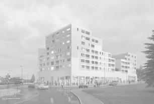
The Planning & Development Proposal for the Sirah area near Katra integrates various aspects of urban planning, land use management, infrastructure provision, and socio-economic development to achieve a sustainable and resilient community. The proposal is guided by principles of environmental stewardship, social equity, economic vitality, and cultural heritage preservation. It addresses the diverse needs and aspirations of residents, businesses, visitors, and future generations, ensuring inclusive and participatory decision-making processes. The proposal comprises the following key elements:
11.1 Residential (R – Zone)
•Rental Housing: Introduce rental housing schemes to provide affordable housing options for low-income households, migrant workers, and transient populations. Collaborate with public and private sector stakeholders to develop rental housing projects with subsidized rents and supportive services.
•Proposed Residential Use: Plan for mixed-income residential neighborhoods with a range of housing types, densities, and tenures to accommodate diverse household needs and preferences. Encourage compact, walkable communities with access to parks, schools, and amenities to promote social interaction and neighborhood vitality.
•Commercial Zone (C – Zone): Designate commercial zones for retail, office, and service activities to support local businesses, generate employment opportunities, and enhance economic vitality. Facilitate mixed-use developments with ground-floor commercial spaces and upper-floor residential units to optimize land use efficiency and pedestrian activity.
•Industrial Zone (I – Zone): Allocate industrial zones for manufacturing, warehousing, and logistics activities to promote economic diversification, value-added production, and job creation. Provide infrastructure and incentives to attract investment in high-tech industries, green manufacturing, and export-oriented enterprises.
•No Development Zone (NDZ): Identify no development zones to preserve environmentally sensitive areas, cultural heritage sites, and scenic landscapes from urban encroachment and degradation. Implement land use regulations and conservation measures to safeguard natural resources, biodiversity, and ecosystem services.
•Forest: Conserve forested areas for ecological, recreational, and cultural purposes, promoting sustainable forest management, biodiversity conservation, and eco-tourism. Develop eco-trails, interpretive centers, and nature-based tourism activities to raise awareness about forest conservation and environmental stewardship.
•Road Network and Transportation: Upgrade road infrastructure to improve connectivity, mobility, and safety for pedestrians, cyclists, and motorists. Prioritize investments in arterial roads, intersection improvements, and pedestrian facilities to enhance traffic flow, reduce congestion, and promote multi-modal transportation options.
•Open & Recreational Space Network: Create a network of open and recreational spaces to provide opportunities for leisure, recreation, and social interaction. Develop parks, playgrounds, and green corridors to enhance urban greenery, biodiversity, and public health outcomes.
•Proposed Land Use: Allocate land uses based on principles of smart growth, compact development, and mixed-use planning to optimize land use efficiency, reduce sprawl, and enhance urban livability. Balance competing demands for residential, commercial, industrial, and open space uses to create vibrant, resilient, and inclusive communities.
11.2 Road Network and Transportation
Develop a comprehensive transportation plan to improve mobility, accessibility, and safety for residents, commuters, and visitors. Integrate land use and transportation planning to promote transit-oriented development, pedestrian-friendly streets, and sustainable mobility options.
•Proposed Hierarchy of Road Network: Establish a hierarchy of roads comprising arterial roads, collector streets, and local roads to facilitate efficient movement of people and goods. Prioritize investments in road widening, intersection upgrades, and traffic calming measures to enhance traffic flow and safety.
•Important Features of Proposed Transportation Network: Enhance public transportation services, including bus rapid transit (BRT), feeder routes, and last-mile connectivity options, to reduce reliance on private vehicles and alleviate congestion. Promote non-motorized transportation modes such as walking and cycling through infrastructure improvements, safe routes, and awareness campaigns.
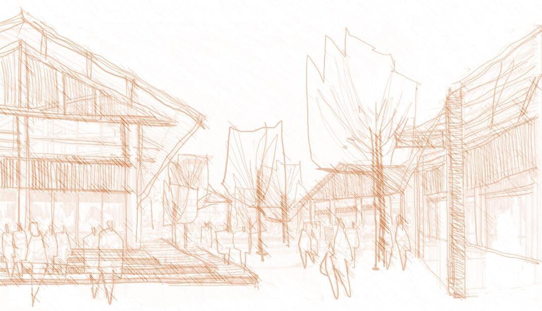
11.3 Open & Recreational Space Network
Proposed Open Space Network: In developing the open space network, it's crucial to identify strategic locations that cater to the diverse needs and preferences of the community. These spaces should be carefully chosen to ensure equitable access for all residents while enhancing the overall quality of life in the area. Parks, plazas, and greenways play a vital role in providing opportunities for relaxation, physical activity, and social interaction.
•Strategic Locations: Through a thorough analysis of the area's topography, existing land use patterns, and demographic distribution, suitable locations for parks, plazas, and greenways can be identified. These locations should be dispersed strategically across the area to ensure accessibility and equitable distribution.
•Nature and Recreation: The design of these open spaces should prioritize the preservation of natural elements and biodiversity while offering recreational amenities such as walking trails, playgrounds, and sports facilities. Incorporating elements of nature into urban spaces has been shown to improve mental well-being and foster a sense of connection to the environment.
•Cultural Amenities: Additionally, these spaces can serve as venues for cultural events, festivals, and community gatherings, contributing to the preservation and celebration of local heritage and traditions. Integrating cultural amenities such as art installations, performance spaces, and interpretive signage can enrich the cultural fabric of the community and promote social cohesion.
•Community Engagement: Public participation in the design and programming of these open spaces is essential to ensure that they meet the needs and aspirations of the community. Through participatory planning processes, residents can provide valuable insights and ideas for the creation of inclusive and vibrant public spaces that reflect the diversity and character of the community.
11.4 Proposed Land Use
Proposed Land Use Breakup of the Notified Area: The allocation of land uses within the notified area should be guided by principles of sustainability, efficiency, and community wellbeing. By carefully considering site suitability, market demand, and community preferences, the proposed land use plan aims to optimize land use efficiency while minimizing conflicts and enhancing urban livability.
•Site Suitability: Assessing the suitability of land for various uses involves considering factors such as soil conditions, topography, infrastructure availability, and environmental sensitivity. Areas unsuitable for intensive development, such as floodplains or steep slopes, may be designated for conservation or recreational purposes.
•Market Demand: Understanding the demand for different types of land uses, including residential, commercial, industrial, and institutional, is essential for guiding development decisions. Market studies and demographic analyses can provide insights into current and future demand trends, informing land use allocation strategies.
•Community Preferences: Engaging with the community to understand their preferences and priorities for land use can help ensure that the proposed plan reflects the needs and aspirations of residents. Surveys, workshops, and public hearings can be used to solicit feedback and input from stakeholders, empowering them to shape the future of their neighborhoods. Compatibility: Ensuring compatibility between adjacent land uses is critical for minimizing conflicts and promoting harmonious coexistence within the built environment. Buffer zones, setbacks, and design guidelines can help mitigate potential negative impacts such as noise, traffic congestion, and visual intrusion, enhancing the overall quality of life for residents.
11.5 Comparison of Existing and Proposed Land Use
•Existing Land Use: Evaluate existing land use patterns and trends to identify strengths, weaknesses, opportunities, and threats (SWOT) for future development planning. Analyze land use conflicts, compatibility issues, and infrastructure constraints to inform land use allocation and zoning decisions.
•Proposed Land Use: Develop a land use plan that balances economic, social, and environmental objectives to create a vibrant, resilient, and inclusive community. Integrate land uses to promote mixed-use development, compact urban form, and efficient land use patterns, fostering economic vitality, social equity, and environmental sustainability.


EXISTING SPATIAL ZONES

PROPOSED SPATIAL ZONES
NATURAL COVER AND GREEN ZONES
11.6 Town Planning and Economic Boosters
Incorporating effective town planning strategies and economic boosters is essential for fostering sustainable development, promoting economic growth, and enhancing the quality of life in the Sirah area near Katra. This section outlines key initiatives and interventions aimed at revitalizing the built environment, stimulating economic activity, and creating vibrant urban spaces:
11.6.1 Mixed-Use Development Zones
•Introduction: Promote mixed-use development zones that integrate residential, commercial, and recreational uses within walkable neighborhoods. Encourage compact, higher-density developments to maximize land use efficiency and minimize sprawl.
•Economic Booster: Mixed-use developments attract investment, support small businesses, and create employment opportunities in diverse sectors such as retail, hospitality, and entertainment. By fostering vibrant urban centers with active street life and cultural amenities, mixed-use zones contribute to economic resilience and social cohesion.
11.6.2 Heritage Preservation and Cultural Tourism
•Introduction: Preserve and promote the cultural heritage of the Sirah area through heritage conservation initiatives, adaptive reuse projects, and cultural tourism programs. Identify historic sites, traditional crafts, and cultural events that showcase the area's unique identity and heritage.
•Economic Booster: Heritage preservation and cultural tourism drive economic development by attracting tourists, generating revenue for local businesses, and creating jobs in the hospitality, arts, and heritage sectors. By capitalizing on cultural assets and storytelling, the Sirah area can position itself as a compelling destination for heritage tourism, fostering economic growth and community pride.
11.6.3 Innovation Districts and Knowledge Clusters
•Introduction: Establish innovation districts and knowledge clusters that catalyze innovation, entrepreneurship, and knowledge exchange. Create mixed-use environments that bring together businesses, research institutions, startups, and incubators to drive innovation-led growth.
•Economic Booster: Innovation districts and knowledge clusters serve as hubs of economic activity, fostering collaboration, talent retention, and technology transfer. By supporting innovation ecosystems and creative industries, the Sirah area can attract investment, create high-value jobs, and spur economic diversification and competitiveness.
11.6.4 Eco-Industrial Parks and Sustainable Business Practices
•Introduction: Develop eco-industrial parks and promote sustainable business practices that minimize environmental impact, conserve resources, and enhance competitiveness. Design industrial zones with green infrastructure, energy-efficient buildings, and waste recycling facilities.
•Economic Booster: Eco-industrial parks attract environmentally conscious businesses, investors, and consumers, driving demand for green products and services. By embracing sustainability principles and circular economy practices, businesses in the Sirah area can reduce costs, enhance resilience, and gain a competitive edge in domestic and international markets.
11.6.5 Creative Placemaking and Public Art Installations
•Introduction: Embrace creative placemaking and public art installations to activate public spaces, foster community engagement, and celebrate local culture. Encourage artists, designers, and community members to collaborate on placemaking projects that beautify the built environment and inspire civic pride.
•Economic Booster: Creative placemaking enhances the aesthetic appeal, social vibrancy, and economic value of urban spaces, attracting visitors, investors, and residents. By integrating public art, murals, and interactive installations into the urban fabric, the Sirah area can create memorable experiences, support local artists, and boost tourism and economic activity.
11.6.6 Smart City Technologies and Digital Infrastructure
•Introduction: Implement smart city technologies and digital infrastructure to improve service delivery, enhance connectivity, and promote innovation. Deploy sensor networks, data analytics, and digital platforms to optimize resource allocation, streamline operations, and empower citizens.
•Economic Booster: Smart city initiatives drive economic growth by increasing productivity, reducing costs, and attracting investment in digital technologies and related industries. By embracing digitalization and connectivity, the Sirah area can create a conducive environment for tech startups, digital entrepreneurs, and knowledge-based industries, driving economic prosperity and competitiveness.


1. Residential Zone With Allotted Farm Land
2. Cultural Centre
3. Institutional Buildings
4. Playground
5. Mixed Use Complex
6. Recreational Community Zone
7. Water Front
8. River Front
9. Industrial Area
10. Chowk
11. Commercial Front (Existing)
12. Residential Area (Existing
13. Agricultural And Forest Zones (Existing)
14. Hospital (Existing)
15. University (Existing)
1 3 5 4 2 6 7 1 1 8 9 10 11 12 13 12 13 14 15
Proposed road network Existing road network

Green
Water front Mixed Use Complex
Park Road intersection
Commercial Front
Community Plaza


Mixed use Complex
Community Plaza
Water front and Green park

Street development Plan and Section


Commercial Front and Street Scaping
Existing Domel Katra Road
Proposal on Domel Katra Road
12. Development Control Rules and Regulation
Preamble
The preamble sets out the purpose, scope, and objectives of the development control rules and regulations, providing a legal framework for land use planning, development management, and regulatory compliance.
Short Title, Applicability & Commencement
•The short title identifies the document as the Development Control Rules and Regulations for the Sirah area near Katra, Jammu, India.
•The applicability clause specifies the geographical scope and jurisdictional boundaries of the rules, ensuring consistency and uniformity in their implementation.
•The commencement clause stipulates the effective date of the rules, marking the beginning of their enforceability and legal validity.
12.1 Land Use Zoning Regulations
•Land Use Zones Classifications: Land use zones categorize areas based on their intended use, development intensity, and compatibility with surrounding land uses, facilitating orderly development and land management.
•Residential Use Zone: Residential zones accommodate housing development, providing a range of housing types, densities, and amenities to meet diverse housing needs and preferences.
•Commercial Use Zone: Commercial zones support retail, office, and service activities, fostering economic vitality, pedestrian activity, and urban vibrancy in commercial centers.
•Manufacturing Use Zone: Manufacturing zones provide space for industrial activities, including manufacturing, processing, and assembly, ensuring compatibility with adjacent land uses and minimizing environmental impacts.
•Public, Semi-Public Facilities Use Zone, Utilities Use Zone, and Religious Use Zone: Public and semi-public zones house institutional, civic, and community facilities, serving the needs of residents, businesses, and visitors.
•Open Space Use Zone: Open space zones preserve natural, recreational, and cultural assets, providing opportunities for outdoor recreation, biodiversity conservation, and scenic enjoyment.
•Conservation Use Zone: Conservation zones protect environmentally sensitive areas, including wetlands, forests, and wildlife habitats, from incompatible development, ensuring ecological integrity and resilience.
•Forest Zone: Forest zones conserve forested areas for ecological, recreational, and economic purposes, promoting sustainable forest management, biodiversity conservation, and carbon sequestration.
•Water Body Zone: Water body zones safeguard water bodies from pollution, encroachment, and degradation, ensuring water quality, habitat preservation, and recreational opportunities.
•Special Reservations Zone: Special reservations zones allocate land for specific purposes such as road widening, utilities, public facilities, and heritage conservation, guiding development and investment decisions.
•Transportation and Communication Use Zone: Transportation and communication zones accommodate transportation infrastructure, including roads, railways, airports, and communication networks, facilitating connectivity, mobility, and accessibility.
12.2 Bye Laws
•Residential Use Zone: Bye-laws for residential zones regulate building height, setback, density, and floor area ratio (FAR), ensuring adequate light, ventilation, privacy, and safety for residents.
•Commercial: Bye-laws for commercial zones govern building design, signage, parking, and land use intensity, promoting pedestrian-friendly environments, business viability, and aesthetic quality.
•Public and Semi-Public: Bye-laws for public and semi-public zones prescribe standards for institutional buildings, open spaces, and utilities, enhancing functionality, accessibility, and amenity value.
•Industrial Use: Bye-laws for industrial zones specify requirements for site layout, pollution control, safety measures, and employee facilities, ensuring compliance with environmental regulations and occupational health standards.