
25 minute read
Voiced

from Return on Investment: How putting a dollar figure on the value of conserved lands can help save more

DJ GLISSON, II / FIREFLY IMAGEWORKS
Land Can Bring Peace
RAMONA PETERS IS CHAIR OF THE NATIVE LAND CONSERVANCY, THE FIRST NATIVE-RUN LAND CONSERVATION GROUP EAST OF THE MISSISSIPPI. THIS ESSAY IS ADAPTED FROM A PRESENTATION SHE GAVE TO THE LAND TRUST COMMUNITY IN JUNE 2021.
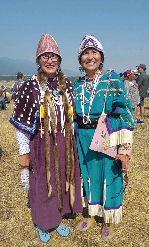
I am a member of the Mashpee Wampanoag Tribe. We are first contact people; our home territory is where the Mayflower landed.
It was sort of a dream to have a way in which Indigenous people could get land back. The Native Land Conservancy (based in Mashpee, Massachusetts) has an all-Indigenous board so that our worldview is represented in the policies we make about acquiring land, restoring it, and also how we share it. Five different tribal groups are represented on our board.
< Ramona Peters on a recent visit to Muddy Pond Wilderness Preserve.
One of our major efforts is to provide access for our people to revisit the lands of our ancestors. We’ve heard many stories about the past and things that happened in certain areas. There are many special places that are still of great importance to us.
We have acquired some land but not as much as we would like. We’re also gaining access to land through cultural respect agreements, which are actually easements in legal terms.
Native people find themselves mistreated quite a bit when we enter the woods that are not our backyard. Even when we go on trails that are conservation land, we find ourselves confronted by someone questioning our right to be there or what we are up to. Having an actual agreement with a conservation trust, private landowner or municipality is a way of protecting our people, especially during ceremony. We want to go and commune in special places, to give respect, to collect plants and medicines that grow only in specific areas, and to do this without harassment or interference or even being observed in some cases.
The Dennis Conservation Land Trust shares special access with us at Chase Garden Creek, 250 acres of uplands and wetlands on Cape Cod Bay. It’s the closest parcel where we can freely do ceremonies, to say greetings and give thanks to the right whales that come in during the summer.
Another friend is Northeast Wilderness Trust (NEWT). We have an MOU with them to facilitate certain ceremonies and journeys that we would like to do on their marvelous 322 acres of pine woodlands at Muddy Pond Wilderness Preserve in Kingston, Massachusetts. There are not many spaces around here as big and vast, so having that level of experience in the woods is something we dream of. They also launched a program this summer for Indigenous interns. We are working with NEWT in a number of ways to try to understand the future, to learn things together about what the future might look like for all of us in light of the climate crisis. How will we behave on the land?
And something amazing happened recently: The Commonwealth of Massachusetts has included special language in its conservation restriction purposes that includes access for Indigenous cultural landscapes— places that have value to us, like springs and ponds and even certain slopes of hills that were used for food storage. It also includes provisions for ceremonies and cultural practices and sustainable harvesting of plant life. I’m still in awe, this is wonderful news—we need this.
I think land has the power to generate peace. No matter what state of mind you are in, if you find yourself out in the woods or near the water, peace will come to you relatively quickly. P
By MADELINE BODIN

Remote monitoring technologies let land trusts monitor conserved lands from afar, during a pandemic and after
A view from above shows cattle on the move in Colorado.
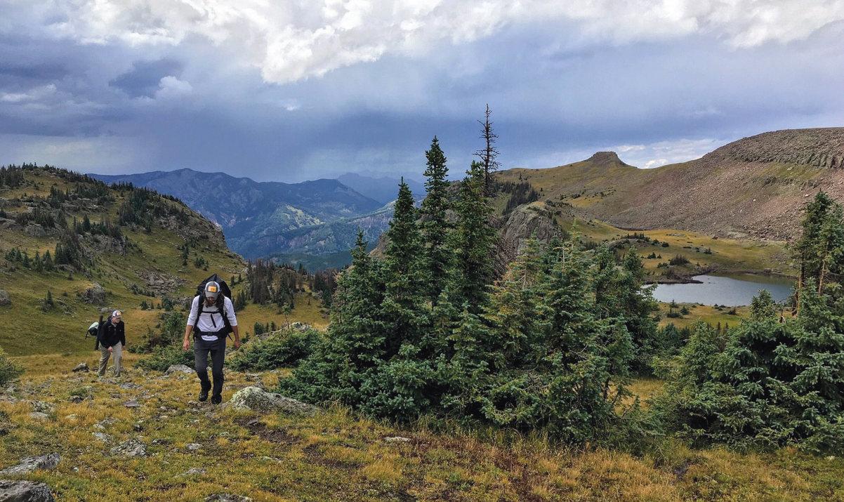
Joel Nystrom (foreground) and Andrew Bushnell on a monitoring trip for Colorado Open Lands in a particularly remote and difficult-to-access property.
At the Upper Savannah Land Trust (USLT), a “plucky band of volunteers”—mostly board members— uses a simple checklist when they walk or drive around properties to conduct annual monitoring of 53,000 acres under conservation easement in western South Carolina. But Wade Harrison, USLT’s part-time executive director and only staffer, wanted to lighten their load.
“It’s not practical for even the most enthusiastic volunteer to examine every acre of a 5,000-acre property, every year,” says Harrison. The land trust’s board had already approved funds for a few high-resolution images of some of USLT’s biggest easements, so the organization was ready when the Land Trust Alliance offered a new opportunity.
In April, the Alliance announced its first grants, in partnership with The Nature Conservancy in California (TNC CA), to support land trusts in integrating remote monitoring technologies, such as satellite and aerial imagery, into their work of stewarding conserved land. USLT is one of 18 land trust projects nationwide that were awarded a total of $219,000 in grants.
“The Alliance has been responding to a need in the land trust community,” says Jake Faber, who oversaw the Alliance’s remote monitoring program from April 2020 to July 2021.

Wade Harrison of Upper Savannah Land Trust monitors a working forest property in Edgefield County, South Carolina. The planted loblolly pine trees in the foreground are in their third growing season; in a few years the view will be a wall of vegetation.
“In the past few years, remote monitoring systems have become cheaper and more accessible,” Faber says. This not only makes them a useful technology, but also one with the potential to save land trusts money and time. “When you don’t have to travel to a property to complete monitoring, your staff has time for other conservation priorities.” Traditional in-person, on-site monitoring can be challenging to achieve every year. Beyond funding and capacity concerns, there can be other obstacles, such as scheduling, weather, accessibility of properties, safety of field visits and more. Remote monitoring—
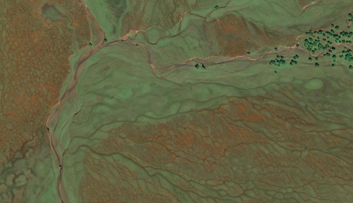
Satellite image of a Northern California ranch under conservation easement. The image provides monitoring insights on the uses and conditions of the property's annual grasslands, oak savannas and vernal pools.

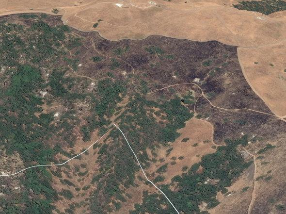
Aerial image of a ranch in Colorado featuring a braided headwater stream meandering through a riparian zone dominated by willow species. This image shows oxbows and remnants of previous stream channels.
Satellite image of a 5,000-acre cattle ranch in California (top) and the same property photographed from the ground (below). Remote monitoring offers insights on the extent and severity of damage from a recent wildfire on the property, under conservation easement with The Nature Conservancy. |
TNC CA

TNC CA which includes any tool, such as aerial or satellite imagery, that enables you to make observations about a property without having to physically be on site—not only helps alleviate these challenges, it can provide a new perspective on conservation.
“Observing changes on the landscape can be difficult for many reasons,” Faber notes. “Often stewards are limited by what they can see with their own eyes, and they may miss things—like difficult-toreach corners of a property or subtle seasonal changes—by using the same in-person methods every year.” With a more diverse set of tools available, stewards can gather a more complete picture of the conditions on a property and often better address emerging concerns.
Beyond offering a more holistic view of a conserved property, there are many other reasons that remote monitoring might appeal to stewardship teams. “It can be a great option from an equity perspective,” adds Faber. “For instance, by making the monitoring process more inclusive for people with mobility limitations who might have trouble getting out to walk on rough terrain or people who feel uncomfortable going to a remote area alone.”
And, as the COVID-19 pandemic emerged, land trusts sought out remote monitoring to help keep their stewards and community members safe. “COVID-19 brought in the consideration of health risks and logistical issues of on-the-ground monitoring during a pandemic,” says Joel Nystrom, stewardship program manager for Colorado Open Lands (COL).
Getting Ahead of the Curve
While land trusts have been using remote monitoring for years, they often relied on imagery that was freely available from government satellites, such as NASA and the European Space Agency. But such imagery did not provide the quality of resolution necessary for monitoring conservation lands. Commercial satellite images had a higher resolution but were expensive, and the resolution was still not adequate for their needs.
Not long after project director Ethan Inlander joined TNC CA in 2014, that had changed. Commercial satellite imagery had improved in quality and come down in price. Using remotely captured imagery became a higher priority.
Past efforts had involved home-grown approaches to integrate remote images with monitoring and reporting management software, but TNC CA wanted to develop a new remote-based monitoring platform and workflow, says Inlander. In 2019, TNC CA began its first full-scale pilot project, selecting eight of its 25 conservation monitors to give the technology a test drive. The eight staffers monitored 40% of the chapter’s conservation easement acreage among them, Inlander says.
The 2019 pilot project proved successful. When the pandemic struck in 2020 and traditional in-person easement monitoring became nearly impossible, TNC CA’s remote monitoring system was immediately opened up to everyone who monitors fee and easement properties for the chapter. The organization also supported the adoption of the program by 13 other TNC chapters in 2020, Inlander says.
“It has been extremely helpful to work with teams across TNC and with other land trusts to learn more about how these tools can be implemented across such a diverse range of geographies and organizations,” Inlander says. “We see great value in sharing
what we have been learning, and through our partnership with the Alliance, we’re excited to see so much growth in the momentum and peer learning opportunities around remote monitoring.”
New Times, Technologies and Techniques
In the early spring of 2020, members of Keep It Colorado—a statewide nonprofit coalition of conservation organizations, including land trusts—became concerned about how pandemic restrictions might affect their ability to perform annual easement monitoring—normally conducted in-person—during the fast-approaching monitoring season.
“Someone suggested remote monitoring using satellite and aerial imaging,” says Linda Lidov, director of membership and communications. “We asked, ‘How can we help with this?’” In response, Keep It Colorado secured $205,000 in grants from Great Outdoors Colorado (GOCO) and the Gates Family Foundation to fund remote monitoring programs for its members.
Through the program, 12 Colorado land trusts were able to use remote monitoring technologies to steward over 1.6 million acres across the state.
One of those was the Colorado Cattlemen’s Agricultural Land Trust (CCALT), which works with ranchers and farmers to conserve agricultural lands on a landscape scale. CCALT holds conservation easements on over 1,000 square miles throughout Colorado. CCALT was well-equipped when the pandemic struck: Conservation Manager Brad Cory has a background in geographic information system (GIS) technology and the land trust had already been using passenger flights to support monitoring for years, so monitoring easements with remote imagery was a logical choice.
“Early in the pandemic we switched to 100% remote monitoring,” Cory says. “The majority of our staff is on the Front Range and many of the properties and families we work with are relatively isolated. The last thing we wanted was to make people sick.”
“We had a positive experience,” Cory says of the Keep It Colorado remote monitoring pilot project. “It was certainly cost effective not paying people to drive all over the state, paying for gas and hotels.


View of the Hudson River and surrounding mountains in fall.
Even the imagery itself was more affordable than expected.” He liked that every image was from a sunny day, which gives a better view of a property than an in-person visit on a rainy day. “It’s a great tool.”
Still, CCALT is excited to be returning to its usual routine and visit every easement in person in 2021. “It’s worth it to get out to every property,” Cory says. “We are so relationship-focused here. Our staff is accustomed to going and spending hours on each of the 539 properties that we hold easements on, catching up and building relationships. It was hard for us to set that aside.”
For Julia Rogers of Hudson Highlands Land Trust (HHLT) in New York, remote monitoring helped to foster relationships with landowners.
“The experience was surprisingly positive,” says Rogers. “Remote monitoring lets me spend more time with landowners.” And landowners are excited by the aerial images, even landowners who are otherwise private and reluctant to answer questions. Rogers says, “We’ve had people ask for imagery.”
In 2020, HHLT staff started using remote monitoring to leverage new technologies to enhance stewardship efforts in between annual in-person visits. They received a remote monitoring grant from the Alliance and TNC CA in 2021 to help monitor their 2,500 acres of conserved lands under easement plus 515 acres of fee lands. Now they are piloting an automated change detection analysis that compares monthly satellite images and alerts the land trust to changes.
But, while in-house expertise helped the project go smoothly overall, the cutting-edge change-detection technology has been a learning process. One company’s pilot technology didn’t have high enough resolution to note changes on HHLT’s smaller easements, which average 25 acres, but range in size from less than an acre to 150 acres.

“We need to see a few trees coming down or a swimming pool coming in,” Rogers says. The grant from the Alliance and TNC CA is letting them give a different change detection technology a try.
For Colorado Open Lands (COL), analytical tools available through satellite imagery, such as Normalized Difference Vegetation Index (NDVI), were appealing, Nystrom says. NDVI uses different wavelengths of light to measure vegetation growth, which is helpful for monitoring easements where native vegetation is an important conservation value, or to ensure the landowners conform to guidelines against overgrazing, Nystrom says.
“We have rangeland management experts on staff, but not everybody who goes out monitoring has that expertise,” he says.
In a normal year, interns, volunteers, paid contractors and staff members visit conserved properties to conduct annual easement monitoring. In 2020, because of health risks and logistical issues, all properties were monitored remotely, Nystrom says. The move saved COL $50,000.
“If 2020 is any indication, we are believers in remote monitoring and plan to use it as one tool in our monitoring toolbox going forward,” Nystrom says. COL used one property as a test for NDVI analysis and plans to use it more in the future. In 2021, COL will monitor half of its easements in person and half remotely, Nystrom says. It expects to save $30,000 over past years’ monitoring costs.
Looking Ahead: A Wealth of Ideas
While the Colorado grant program was pandemic-driven and focused on easement monitoring, Lidov says that it nurtured a wealth of ideas by the participating land trusts to expand their use of the technology. Several land trusts are exploring remote imaging to monitor for weed infestations and other vegetation changes, scout prospective conservation properties, examine conservation issues at the watershed level and analyze where to focus restoration efforts.
For the future, HHLT is talking about how some of remote monitoring’s special features would let them look at trends across the landscape, such as measuring carbon storage in the region’s forests and how climate change is impacting forests.
USLT began their remote monitoring project in the summer of 2021, so efforts are still underway. But Harrison sees it as preparation for a future that will lessen demands on their volunteer easement monitors and help their monitoring system be sustainable in the years ahead. “It’s worth it,” he says.
The Alliance continues to expand its work, offering land trusts additional remote monitoring support as well. Faber notes that “the Alliance is excited to be starting a new program in partnership with the U.S. Department of Agriculture’s Natural Resources Conservation Service this year to design a remote monitoring toolkit that will help land trusts and agency partners as they continue to explore these tools.”
“Ultimately, remote monitoring is a powerful tool to help make land trusts more effective and efficient,” says Faber. “It offers enormous potential for how we observe the landscape, how we monitor conservation values and even how we connect with landowners.” P
MADELINE BODIN is a freelance environmental and science journalist.
Resources
A report, “Remote Monitoring Technologies for Colorado Land Trusts,” assesses lessons learned from the Keep It Colorado pilot project. Read the report and learn more about the Alliance's remote monitoring grant program, including how to apply for the next round (due in November 2021), at lta.org/remote-monitoring. P
A BLESSING ON BOTH SIDES
The Transformative Power of Partnerships between Land TrustS and Tribal Members
By MARINA SCHAUFFLER
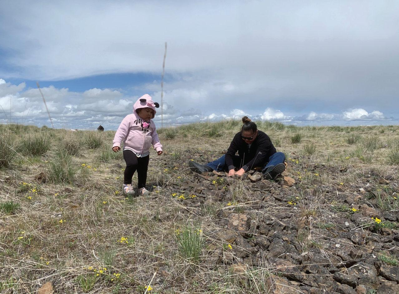
On a snowy weekend this spring, Rebecca Miles traveled with her mother and toddler daughter 100 miles from her home on the Nez Perce reservation in Lapwai, Idaho, to Wallowa Valley in Oregon, ancestral homeland of the Nimiipuu people. “We have to be able to get out and gather, no matter what the weather,” she says.
Hosted by Wallowa Land Trust (WLT) on a Nature Conservancy- owned preserve, tribal members gathered to dig spring roots and reunite with other Nez Perce. Miles and her family enjoyed the fellowship and harvesting rituals, but also walked in solitude
“imagining our people walking those steps before us … it was medicinal to be out there.” There was time for “reconnecting with the land that our ancestors were on. It was such a spiritual moment for all of us who came.”
The weekend concluded with a community potluck where local ranchers and farmers joined the Nez Perce for shared food and moving words, Miles says, adding that the gathering was “such a blessing on both sides.”
From its formation in 2004, WLT has collaborated on land protection with the Nez Perce. Miles got to know land trust staff while working as the tribe’s executive director and serving on its land acquisition committee. From the start, she recalls, WLT “kept us in the loop about various properties and opportunities. They actively sought us out and understood they were residing in the homeland of the Nez Perce. They didn’t see us just as a stakeholder or interest group.” “The land trust has a very big role in listening to the tribe and going out and protecting properties of mutual interest,” Miles adds, citing the decade-long “uphill climb” that conservation
groups undertook to protect the 1,800-acre East Moraine of Wallowa Lake from trophy-home development. According to Miles, that land holds significance for the tribe and will help in “restoring history and stories that would have been lost. It brings a recognition back to our people.”
WLT staff are able to “communicate well the intentions of the land trust,” Miles notes, even to tribal members who may be distrustful. “They make sure they are listening, and are constantly asking for permission and guidance.” Interactions typically involve “lots of laughter,” Miles adds. “Laughter is medicine.” The result has been “creating relationships where they couldn’t possibly exist without the effort.”
The May gathering “speaks volumes” about that commitment, in Miles’ opinion, particularly since a large turnout and bad camping weather left WLT scrambling to raise extra funds and find sufficient lodgings, food and travel expenses (getting help, in part, from the Land Trust Alliance). Miles credits WLT’s hardworking staff with having a “let’s do it” attitude, modeled by Executive Director Kathleen Ackley. “She made it happen; she’s not one of those people who would turn anyone away.”
Losing their ancestral home
For millennia, the Nez Perce enjoyed a peaceable way of life that relied on seasons spent in Wallowa Valley gathering foods and medicines, fishing and hunting. After settlers arrived in the 1800s, the tribe initially ceded land to the federal government in an 1855 treaty to keep peace and retain its right to self-governance. But then gold was discovered on the tribe’s remaining lands and miners began trespassing.
A subsequent treaty in 1863, one widely viewed as fraudulent, cut tribal land holdings by nearly 90%. In 1873, President Ulysses S. Grant affirmed that Wallowa Valley was a Nez Perce reservation, but two years later he rescinded that executive order—putting all of the land in public domain. In 1877, the U.S. military came to forcibly evict Chief Joseph’s band of Nez Perce, launching a war that spanned 1,500 miles before the band surrendered. The Nez Perce who survived were scattered to sites throughout North America, with many residing today on three reservations between 75 and 275 miles from Wallowa Valley: Nez Perce Reservation in Lapwai, Idaho; Confederated Tribes of the Colville Reservation in Nespelem, Washington; and Confederated Tribes of the Umatilla Indian Reservation in Mission, Oregon.
WLT staff are mindful of “that terrible history to overcome,” Ackley says. In 2018, two board members and two staff members traveled to all three reservations for listening sessions, hearing Nez Perce perspectives on conservation and engaging in what she calls “deep, thoughtful and sometimes difficult conversations.”
Nez Perce participants voiced a need for access to ancestral lands—to gather traditional foods and medicines and to maintain the rituals that land requires of them. “The conversations broadened our understanding of stewardship,” Ackley reflects, as land trust participants realized how little they knew of “the ancient knowledge
KATHLEEN ACKLEY
^ Carla Timentwa and her sister JoAnn Kauffman, both
members of the Nez Perce Tribe, at a recent land-back blessing ceremony in Oregon. Says Timentwa: “We are truly fortunate to witness the return of our people to this land.”
KATHLEEN ACKLEY/WLT

< Artist rendering of a Cherokee village with council house, circa A.D. 1200-1500.

ILLUSTRATED BY ELAYNE SEARS
^ The view of Cowee Mound from the Mainspring-owned property.
RALPH PRESTON

PHOTO COURTESY OF MAINSPRING CONSERVATION TRUST
^ Jordan Smith (second from left) of Mainspring Conservation Trust and Joseph
Owle (far right) of the Eastern Band of Cherokee Indians at a signing event.
about land management practices of people who evolved with this land.”
The listening sessions sparked the idea for the spring gatherings. After a small group came in 2019 (and the pandemic forced cancellation of the 2020 gathering), the number of tribal members interested in participating more than quintupled this year. The closing potluck this year also drew greater community participation.
As tribal members forge relationships directly with community members, Ackley hopes the gathering will become less of a land trust event and one more broadly hosted by the entire Wallowa community. “The idea is to foster these relationships where Wallowa Land Trust doesn’t have to be the middle person,” says Ackley. Miles already sees that process underway, with greater trust and learning on both sides.
No one can change that “this is the present-day reality of private ownership,” Miles adds, “but we can be compassionate and empathetic to each other.” Ackley reflects that “these things take time,” but she has witnessed encouraging changes in just three years. “We try to open doors and then let some things happen on their own,” she added. “You have to be willing to let go of the power.”
In the Blue Ridge Mountains of western North Carolina, Mainspring Conservation Trust has collaborated for decades with Cherokee people in their ancestral heartland. Cherokees have lived for more than 10,000 years in a territory that may have spanned 125,000 square miles. Now the Eastern Band of Cherokee Indians (EBCI) resides primarily in the Qualla Boundary, a 100-square-mile sovereign nation adjoining Great Smoky Mountains National Park.
“Every piece of land we work on is part of their ancestral lands,” observes Jordan Smith, Mainspring’s executive director. “Some of the most culturally significant Cherokee lands are also the most threatened by development, as they lie outside the Qualla Boundary.” That recognition has informed the land trust’s work to preserve cultural heritage since it formed. In 2004, Mainspring forged a cooperative agreement with Cherokee basket makers so they could harvest rivercane on conserved lands, and subsequently it planted large oak and butternut stands for Cherokee use.
When an opportunity arose to protect 912 acres in the headwaters of the Qualla Boundary’s drinking water supply, Smith brought that project to Joseph Owle, the EBCI’s secretary of agriculture and natural resources, to gauge the tribe’s interest.
“We try not to make any assumptions,” Smith says. “A project may look great to us, but they may see it differently.” In this case, the land was of “high interest,” Owle affirms, and, through a partnership that included the land trust, the state, The Conservation Fund and the local town, the tribe acquired the land earlier this year with the state holding a conservation easement. “Mainspring carried all the heavy weight,” Owle says. “It wouldn’t have happened without them.”
Mainspring negotiated with the state to ensure that the easement addressed the EBCI’s needs—to practice artisanal resource harvesting, have six primitive campsites and build mountain bike trails without harming the forest ecosystem. Getting accommodations for tribal uses, Smith says, led to “an interesting conversation” with state officials. Conservationists think about protecting high-value settings, but “it’s all special to the Cherokee,” Smith notes. “Who are we to tell them [about land stewardship]? They took better care of these lands than we ever will.”
Mainspring “considers things from a tribal perspective,” notes Thomas Cabe, the EBCI’s forest resource specialist, and demonstrates “more of a respect to the land and to what that land means to people who have occupied it for millennia.” That has helped forge a partnership that Owle calls “unique and very fulfilling,” one that is “mutually advantageous.”
Different Landscapes, Similar Story
Members of the EBCI are descended from roughly 1,000 Cherokees who managed to remain in their homeland through the brutal decade following the 1830 Indian Removal Act.
Like the Nez Perce, the Cherokee people had lived peaceably with settlers. Discovery of gold on their lands in 1835 brought an influx of miners and pressure from Georgia state leaders to remove Cherokee residents, despite an 1832 Supreme Court decision upholding their independence.
In 1838, President Andrew Jackson authorized the capture at bayonet point of more than 15,000 Cherokees who were held in forts before being forced to march west to “Indian Territory.” More than a quarter of those made to walk the Trail of Tears died.
In the Blue Ridge, the Trail of Tears follows the Little Tennessee River, where the Cowee, Nikwasi and Watauga mounds still denote the location of Cherokee towns, each of which had a council house perched atop a high earthen mound. Siting towns by running water was not simply a practical consideration of arable farmland, notes Ben Steere, a Mainspring board member and archaeologist at Western Carolina University. It grew from a millennia-old practice of “going to water,” taking ritual baths before significant occasions— and doing so in waters where your ancestors bathed.
The riverside mound sites hold great significance for Cherokee people today, and Mainspring has helped get three of them back into tribal control. When a conflict arose in 2015 over town management of the Nikwasi Mound, Mainspring organized community members to begin a reconciliation process. That dialogue led to formation of a nonprofit, the Nikwasi Initiative, with representatives of the land trust, EBCI, the town and the county. The initiative eventually took ownership of Nikwasi Mound and is working on a regional cultural corridor with interpretive signage highlighting Cherokee history.
Seven miles downstream is Cowee Mound, what Cabe describes as a “stock exchange and diplomatic site, where cultures intersected and people could reach a meeting of minds.” Mainspring helped the EBCI acquire Cowee Mound in 2007, but the view to nearby Hall’s Mountain—important to Cherokees and considered part of their sacred ancestral ground—remained threatened by development.
Following an eight-year process, in which the tribe drew support from Mainspring, The Wilderness Society and the U.S. Forest Service, the EBCI now holds 150 acres on Hall’s Mountain, and has plans for an “Immersion School” there, offering young students natural resource and cultural resource teaching (in Cherokee language) so they can gain what Cabe calls “a more definitive sense of what it means to be Cherokee in this place.”
Mainspring stepped in at critical junctures, including putting a payment down while the tribe awaited federal grant funds. “It would not have been possible” without them, Cabe says. They were a “bird dog catching these opportunities.”
In the relationship that the EBCI has with Mainspring, Cabe notes, we have “absolute deference to each other; the purpose for which we’re working is understood.” Both entities, he adds, have a multi-generational perspective; the work of partnership is “for the now but also for the future.” P
NAVIGATING NEW TERRAIN
Land trusts are increasingly playing a role in helping Indigenous people regain access to lands and natural resources. Yet conservation groups can inadvertently limit Indigenous participation when public access provisions prevent group gatherings or when conservation restrictions prevent traditional gathering of plants or minerals, whether for food, medicine or artisanal uses. Land conservation groups are beginning to consider using different tools to assure access for these traditional Indigenous uses. While land trusts typically have experience interacting with various government processes, it is very different to navigate the processes of tribal governments, the intricacies of tribal land ownership, and the widely varied relations between tribal and state or local governments. P To learn more, review “Tools to expand Indigenous land access” at: firstlightlearningjourney.net/resources.
BY CIONA ULBRICH, co-founder of First Light and senior project manager at Maine Coast Heritage Trust


