4 minute read
Good Getaways


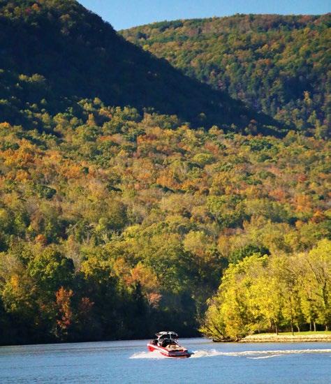
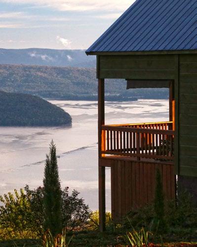
Taking in a five-mile stretch of water, the view of the Tennessee River Gorge from Snooper’s Rock, above, is epic. An elevation of 1,410 feet puts the bluff 776 feet above the river’s horseshoe bend. Left, the I-24 and U.S. 41 bridges cross the river/reservoir four miles upstream from Nickajack Dam. The photo was taken from Look Out Winery (and pizzeria) on U.S. 41. The second ridge back in the photo is where scenic Grant Summit Cabins, pictured at far right, is located.

Advertisement


Nickajack
and the Tennessee River Gorge
Story and photos by David Moore
When Hunter and I stepped out of the dark forest onto Snooper’s Rock, I was hit by a sense of discovery, as if maybe my son and I were the first humans to ever behold this expansive view of the serpentine Tennessee River Gorge.
“First,” of course, is preposterous. Another photographer was already set up there in the predawn gloom hoping to catch a stunning sunrise, maybe with the river fogged over, as it sometimes does, in the pit of the deep gorge. Soon, 15 more people joined our vigil.
As it worked out, sunrise was a flat, gray, overcast bust. I ended up driving again to southeastern Tennessee a few days later for an afternoon shot from Snooper’s – but I truly didn’t mind the drive. The feeling of discovery was still palpable, even though a few others were visiting then, too.
That sensation of discovery, for me, is the exclamation mark that accompanies any trip to this stretch of the Tennessee River from Nickajack Dam up through the relatively narrow, looming walls of the
• Top of the Rock Restaurant

• Nickajack Dam
• Grant Summit Cabins Game Preserve Road • • Suck Creek • Suck Creek Road
• Look Out Winery Snooper’s Rock • • Elder Mountain
Mullins Cove Road •
Hicks Mountain
Taking U.S. 72 north from Guntersville, it’s a little over one hour to Top of the Rock Restaurant and Brewery in Jasper, Tenn. From there, it’s 21 miles to Grant Summit Cabins. From the cabins to Snooper’s Rock, cross the Tennessee on U.S. 41, drive up the Sequatchie Valley on Tenn. 27 to Powells Crossroad, then follow 27 up Walden Ridge, and watch for signs to Prentice Cooper State Forest. Tenn. 27 continues back down the mountain and into Chattanooga, and U.S. 41 loops you out of the gorge.
gorge before reaching Chattanooga 43 miles upstream.
Experiencing the gorge by boat is amazing, but you can thoroughly enjoy this area by car and foot.
Hunter and I stayed two nights at Grant Summit Cabins, which is tucked into the northeast corner of Alabama atop a mountain directly overlooking Nickajack Dam.
On the drive over, we ate in Jasper, Tennessee, at Top of the Rock. It has good food, on-site brewing and a knockout view – a foretaste, really – of where we were heading.
Grant Summit Cabins aren’t exactly central to the area. But the view is tremendous and this was pretty much a road trip anyway, so I’d say they’re perfect.
The drive to Snooper’s Rock takes just over an hour. The route is scenic but a bit involved, with the last six miles on a gravel road. So if you want to catch a sunrise, I suggest a daylight reconnaissance trip first.
The area boasts numerous hiking trails, but before taking off on state land first check the state forestry website. Prentice Cooper State Forest and other areas are closed certain days of the year for hunting. Call ahead: 423-658-5551.
Hunter would have probably been up for any hike, but his old, gray dad’s hiking legs ain’t what they used be. So for the full Saturday we had, we took a loop drive back over the river, up the scenic Sequatchie Valley, across Hicks Mountain and – still on the same road, down into Chattanooga.
Next trip, I want to drive Mullins Cove Road which hugs north shore of the river through the gorge. And, for sure, revisit Snooper’s Rock.
Good Life Magazine
For more information: • topoftherockbrewery.com • grantsummitcabins. holidayfuture.com • www.tn.gov/agriculture/forests/ state-forests/prentice-cooper.html
Hunter Moore, upper right, explores along Suck Creek, which parallels Tenn. 27 as it tumbles down Hicks Mountain into the gorge. At right, is a view of the river from US 41 at the bottom of the gorge.