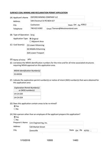
SURFACE COAL MINING AND RECLAMATION PERMIT APPLICATION OXFORD MINING COMPANY LLC
(A) Applicant's Name Address
544 Chestnut St PO BOX 427
City
Coshocton
Telephone
7406226302
State OH Zip 43812 Email TJensen@Westmoreland.com
(B) Type of Operation: Strip Application Type: (C) Coal Seam(s)
Original Adjacent Area
(5) Lower Kittanning (6) Middle Kittanning (6A) Lower Freeport
(D) Name of mine APV (E) List below the MSHA identification numbers for the mine and for all mineassociated structures requiring MSHA approval on this application area. MSHA Identification Number(s) 3304336 (F) Indicate the exploration permit number(s) or notice of intent (NOI) number(s) that were obtained for this application area Exploration Permit Number(s) or (NOI) number(s) 14CA020 14CA024 (G) Does this application contain areas to be remined? Yes No (H) Did a person other than an employee of the applicant prepare this application? Yes No Preparer's Name Linn Engineering, Inc. Address
534 Market Street
City
Zanesville
1/10/2018
State OH Zip 43701
10555
1/483
Telephone
740Â452Â7434 Email linneng@sbcglobal.net
1/10/2018
10555
2/483
Part 1: LEGAL, FINANCIAL, COMPLIANCE, AND RELATED INFORMATION A. IDENTIFICATION OF INTERESTS (1) Will there be a mine operator other than the applicant? Yes No
1/10/2018
10555
3/483
Part 1: LEGAL, FINANCIAL, COMPLIANCE, AND RELATED INFORMATION A. IDENTIFICATION OF INTERESTS (2) Provide the following for the person or entity who will pay the abandoned mine land reclamation fee for the applicant. Name
Oxford Mining Company, LLC
Address
PO Box 427
City
Coshocton
Telephone
7406226302
State OH
Zip 43812 Â
(3) Provide the following for all persons owning or controlling the coal to be mined by another person under a lease, sublease, or other contract and (a) having the right to receive the coal after mining, or (b) having the authority to determine the manner in which another person conducts coal mining operations. If none, check box:  . If any person listed is a business entity and not an individual provide the information below. The Centralized Ownership and Control File (COCF) must be updated to include that entity if not already part of the COCF. (4) List below the person or persons primarily responsible for ensuring that the applicant will comply with Chapter 1513 of the Revised Code and the rules adopted pursuant thereto while mining and reclaiming the area for which this permit is requested. Gregory Honish (5) Has the applicant or any person or entity listed in the Centralized Ownership and Control File (COCF) held a coal mining permit in the United States within the five years preceding the date of this application? Yes No Submit Permit List
(6) Does the applicant or any person or entity listed on the Centralized Ownership and Control File (COCF) have a pending coal mining application in any state of the United States? Yes No Submit Pending Application List (7) Is the Certificate of Insurance in the Centralized Ownership and Control File (COCF) current? Yes No
1/10/2018
10555
4/483
Permit List.pdf AcroExch.Document 248 KB
Pending Application List.pdf AcroExch.Document 68.3 KB
1/10/2018
10555
5/483
OHIO DEPARTMENT OF NATURAL RESOURCES DIVISION OF MINERAL RESOURCES MANAGEMENT PERMIT LIST Oxford Mining Company, LLC 1 OF 5 Applicant's Name Application Reference ID APV ‐ Perry State Forest App. Submit the following information for each coal mining operation owned or controlled by either the applicant or by any person who owns or controls the applicant. Name of Business Entity
Oxford Mining Company, LLC
544 Chestnut Street
Address City
Coshocton
State
OH
Zip
43812‐0427
740‐622‐6302 Telephone NOTE: If the identified business entity is not included in the approved centralized ownership & control file (COCF), please forward an original addendum to the Permit List for the appropriate company(s) listing EIN or SSN (last 4 digits) information. DO NOT attach the addendum to EPS as this information is considered sensitive and confidential. Permit Number
State
Regulatory Authority
MSHA Number and Date Issued
D-0287
OH
DMRM
33-04179
01/30/03
D-0361
OH
DMRM
33-04179
01/30/03
D-0661
OH
DMRM
33-03288
12/23/98
D-0676
OH
DMRM
33-00965
12/23/98
D-0796
OH
DMRM
33-04179
01/30/03
D-0838
OH
DMRM
33-02937
12/23/98
D-0981
OH
DMRM
33-04179
01/30/03
D-1086
OH
DMRM
33-04336
08/12/94
D-1149
OH
DMRM
33-04179
01/30/03
D-1152
OH
DMRM
33-00965
12/23/98
D-1164
OH
DMRM
33-04213
08/23/90
D-2014
OH
DMRM
33-04594
09/13/07
D-2097
OH
DMRM
33-03930
05/03/04
D-2122
OH
DMRM
33-00965
12/23/98
D-2146
OH
DMRM
33-04179
01/30/03
D-2161
OH
DMRM
33-04414
04/01/98
D-2198
OH
DMRM
33-00965
12/23/98
D-2238
OH
DMRM
33-00965
12/23/98
If not previously provided in the applicant's COCF, indicate the ownership or control relationship of the business entity with the applicant, including percent of ownership and location in organizational structure and the date the addendum required by the NOTE above was forwarded to the Permitting section:
Revised 04/2013 DNR-744-9014
1/10/2018
10555
6/483
OHIO DEPARTMENT OF NATURAL RESOURCES DIVISION OF MINERAL RESOURCES MANAGEMENT PERMIT LIST Oxford Mining Company, LLC 2 OF 5 Applicant's Name Application Reference ID APV ‐ Perry State Forest App. Submit the following information for each coal mining operation owned or controlled by either the applicant or by any person who owns or controls the applicant. Name of Business Entity
Oxford Mining Company, LLC
544 Chestnut Street
Address City
Coshocton
State
OH
Zip
43812‐0427
740‐622‐6302 Telephone NOTE: If the identified business entity is not included in the approved centralized ownership & control file (COCF), please forward an original addendum to the Permit List for the appropriate company(s) listing EIN or SSN (last 4 digits) information. DO NOT attach the addendum to EPS as this information is considered sensitive and confidential. Permit Number
State
Regulatory Authority
MSHA Number and Date Issued
D-2244
OH
DMRM
33-04213
08/23/90
D-2245
OH
DMRM
33-04179
01/30/03
D-2254
OH
DMRM
33-04336
08/12/94
D-2265
OH
DMRM
33-04180
01/30/03
D-2266
OH
DMRM
33-04584
04/24/07
D-2276
OH
DMRM
33-04179
01/30/03
D-2277
OH
DMRM
33-04413
05/01/00
D-2283
OH
DMRM
33-04584
04/24/07
D-2290
OH
DMRM
33-03770
04/21/05
D-2295
OH
DMRM
33-04180
01/30/03
D-2313
OH
DMRM
33-00965
12/23/98
D-2315
OH
DMRM
33-00965
12/23/98
D-2318
OH
DMRM
33-04336
08/12/94
D-2319
OH
DMRM
33-00965
12/23/98
D-2324
OH
DMRM
33-04179
01/30/03
D-2325
OH
DMRM
33-04179
01/30/03
D-2329
OH
DMRM
33-04179
01/30/03
D-2330
OH
DMRM
33-04179
01/30/03
If not previously provided in the applicant's COCF, indicate the ownership or control relationship of the business entity with the applicant, including percent of ownership and location in organizational structure and the date the addendum required by the NOTE above was forwarded to the Permitting section:
Revised 04/2013 DNR-744-9014
1/10/2018
10555
7/483
OHIO DEPARTMENT OF NATURAL RESOURCES DIVISION OF MINERAL RESOURCES MANAGEMENT PERMIT LIST Oxford Mining Company, LLC 3 OF 5 Applicant's Name Application Reference ID APV ‐ Perry State Forest App. Submit the following information for each coal mining operation owned or controlled by either the applicant or by any person who owns or controls the applicant. Name of Business Entity
Oxford Mining Company, LLC
544 Chestnut Street
Address City
Coshocton
State
OH
Zip
43812‐0427
740‐622‐6302 Telephone NOTE: If the identified business entity is not included in the approved centralized ownership & control file (COCF), please forward an original addendum to the Permit List for the appropriate company(s) listing EIN or SSN (last 4 digits) information. DO NOT attach the addendum to EPS as this information is considered sensitive and confidential. Permit Number
State
Regulatory Authority
MSHA Number and Date Issued
D-2334
OH
DMRM
33-04624
03/03/09
D-2340
OH
DMRM
33-04179
01/30/03
D-2358
OH
DMRM
33-04585
04/06/07
D-2359
OH
DMRM
33-03930
05/03/04
D-2361
OH
DMRM
33-04179
01/30/03
D-2364
OH
DMRM
33-04181
11/21/89
D-2369
OH
DMRM
33-04538
10/13/04
D-2373
OH
DMRM
33-04213
08/23/90
D-2376
OH
DMRM
33-04336
08/12/94
D-2377
OH
DMRM
33-04213
08/23/90
D-2379
OH
DMRM
33-03770
04/21/05
D-2386
OH
DMRM
33-00965
02/23/12
D-2387
OH
DMRM
33-00965
12/23/98
D-2393
OH
DMRM
33-04179
01/30/03
D-2398
OH
DMRM
33-00965
12/23/98
D-2403
OH
DMRM
33-04624
03/03/09
D-2404
OH
DMRM
33-04179
01/30/03
D-2408
OH
DMRM
33-04538
10/13/04
If not previously provided in the applicant's COCF, indicate the ownership or control relationship of the business entity with the applicant, including percent of ownership and location in organizational structure and the date the addendum required by the NOTE above was forwarded to the Permitting section:
Revised 04/2013 DNR-744-9014
1/10/2018
10555
8/483
OHIO DEPARTMENT OF NATURAL RESOURCES DIVISION OF MINERAL RESOURCES MANAGEMENT PERMIT LIST Oxford Mining Company, LLC 4 OF 5 Applicant's Name Application Reference ID APV ‐ Perry State Forest App. Submit the following information for each coal mining operation owned or controlled by either the applicant or by any person who owns or controls the applicant. Name of Business Entity
Oxford Mining Company, LLC
544 Chestnut Street
Address City
Coshocton
State
OH
Zip
43812‐0427
740‐622‐6302
Telephone
NOTE: If the identified business entity is not included in the approved centralized ownership & control file (COCF), please forward an original addendum to the Permit List for the appropriate company(s) listing EIN or SSN (last 4 digits) information. DO NOT attach the addendum to EPS as this information is considered sensitive and confidential. Permit Number
State
Regulatory Authority
MSHA Number and Date Issued
S-2003-04
WV
WVDEP
46-09067
10/13/04
63080104
PA
PADEP
36-09573
11/06/07
D-2226
OH
DMRM
33-04179
01/30/03
D-2359
OH
DMRM
33-03930
05/03/04
D-2292
OH
DMRM
33-04414
4/1/98
D-2415
OH
DMRM
33-04179
01/30/03
D-2416
OH
DMRM
33-00965
12/23/98
D-2418
OH
DMRM
33-04414
4/1/98
D-2419
OH
DMRM
33-00965
12/23/98
D-2420
OH
DMRM
33-04213
8/1/90
D-2421
OH
DMRM
33-04179
01/30/03
D-2423
OH
DMRM
33-04336
08/12/92
D-2433
OH
DMRM
33-04179
01/30/03
D-2444
OH
DMRM
33-04538
10/13/04
D-2445
OH
DMRM
33-00965
12/23/98
D-2449
OH
DMRM
33-04213
08/23/90
D-2450
OH
DMRM
33-04179
01/30/03
D-2451
OH
DMRM
33-04538
10/13/04
If not previously provided in the applicant's COCF, indicate the ownership or control relationship of the business entity with the applicant, including percent of ownership and location in organizational structure and the date the addendum required by the
Revised 04/2013 DNR-744-9014
1/10/2018
10555
9/483
OHIO DEPARTMENT OF NATURAL RESOURCES DIVISION OF MINERAL RESOURCES MANAGEMENT PERMIT LIST Oxford Mining Company, LLC 5 OF 5 Applicant's Name Application Reference ID APV ‐ Perry State Forest App. Submit the following information for each coal mining operation owned or controlled by either the applicant or by any person who owns or controls the applicant. Oxford Mining Company, LLC
Name of Business Entity Address
544 Chestnut Street
City
Coshocton
State
OH
Telephone
Zip
43812‐0427
740‐622‐6302
NOTE: If the identified business entity is not included in the approved centralized ownership & control file (COCF), please forward an original addendum to the Permit List for the appropriate company(s) listing EIN or SSN (last 4 digits) information. DO NOT attach the addendum to EPS as this information is considered sensitive and confidential. Permit Number
State
Regulatory Authority
D-2463
OH
DMRM
MSHA Number and Date Issued 33-04336
08/12/94
If not previously provided in the applicant's COCF, indicate the ownership or control relationship of the business entity with the applicant, including percent of ownership and location in organizational structure and the date the addendum required by the
1/10/2018
10555
10/483
OHIO DEPARTMENT OF NATURAL RESOURCES DIVISION OF MINERAL RESOURCES MANAGEMENT PERMIT LIST Oxford Mining Company, LLC Applicant's Name Application Reference ID APV - Perry State Forest App. Submit the following information for each coal mining operation owned or controlled by either the applicant or by any person who owns or controls the applicant. Name of Business Entity
42600 Deersville Ridge Road
Address City
Cadiz
State
OH
Daron Coal Company, LLC
Zip
43907
740-942-4393 Telephone NOTE: If the identified business entity is not included in the approved centralized ownership & control file (COCF), please forward an original addendum to the Permit List for the appropriate company(s) listing EIN or SSN (last 4 digits) information. DO NOT attach the addendum to EPS as this information is considered sensitive and confidential. Permit Number
State
Regulatory Authority
D-1181
OH
DMRM
MSHA Number and Date Issued 33-04413
05/01/2000
If not previously provided in the applicant's COCF, indicate the ownership or control relationship of the business entity with the applicant, including percent of ownership and location in organizational structure and the date the addendum required by the NOTE above was forwarded to the Permitting section:
Oxford Mining Company, LLC owns 100% of Daron Coal Company, LLC Revised 04/2013 DNR-744-9014
1/10/2018
10555
11/483
OHIO DEPARTMENT OF NATURAL RESOURCES DIVISION OF MINERAL RESOURCES MANAGEMENT PERMIT LIST Oxford Mining Company, LLC Applicant's Name Application Reference ID APV - Perry State Forest App. Submit the following information for each coal mining operation owned or controlled by either the applicant or by any person who owns or controls the applicant. Name of Business Entity
P.O. Box 205
Address City
Cadiz
State
OH
Harrison Resources, LLC
Zip
43907
740-942-4393 Telephone NOTE: If the identified business entity is not included in the approved centralized ownership & control file (COCF), please forward an original addendum to the Permit List for the appropriate company(s) listing EIN or SSN (last 4 digits) information. DO NOT attach the addendum to EPS as this information is considered sensitive and confidential. Permit Number
State
Regulatory Authority
D-2289
OH
DMRM
MSHA Number and Date Issued 33-04577
10/12/2006
If not previously provided in the applicant's COCF, indicate the ownership or control relationship of the business entity with the applicant, including percent of ownership and location in organizational structure and the date the addendum required by the NOTE above was forwarded to the Permitting section:
Oxford Mining Company, LLC owns 51% of Harrison Resources, LLC Revised 04/2013 DNR-744-9014
1/10/2018
10555
12/483
OHIO DEPARTMENT OF NATURAL RESOURCES DIVISION OF MINERAL RESOURCES MANAGEMENT PERMIT LIST Oxford Mining Company, LLC Applicant's Name Application Reference ID APV - Perry State Forest App. Submit the following information for each coal mining operation owned or controlled by either the applicant or by any person who owns or controls the applicant. Name of Business Entity
Oxford Conesville, LLC
544 Chestnut Street
Address City
Coshocton
State
OH
Zip
43812-0427
740-622-6302 Telephone NOTE: If the identified business entity is not included in the approved centralized ownership & control file (COCF), please forward an original addendum to the Permit List for the appropriate company(s) listing EIN or SSN (last 4 digits) information. DO NOT attach the addendum to EPS as this information is considered sensitive and confidential. Permit Number
State
Regulatory Authority
D-2414
OH
DMRM
MSHA Number and Date Issued 33-03907
6/14/2013
If not previously provided in the applicant's COCF, indicate the ownership or control relationship of the business entity with the applicant, including percent of ownership and location in organizational structure and the date the addendum required by the NOTE above was forwarded to the Permitting section:
Oxford Mining Company, LLC owns 100% of Oxford Conesville, LLC Revised 04/2013 DNR-744-9014
1/10/2018
10555
13/483
OHIO DEPARTMENT OF NATURAL RESOURCES DIVISION OF MINERAL RESOURCES MANAGEMENT PERMIT LIST Oxford Mining Company, LLC Applicant's Name Application Reference ID APV - Perry State Forest App. Submit the following information for each coal mining operation owned or controlled by either the applicant or by any person who owns or controls the applicant. Name of Business Entity Address
Oxford Mining Company, Inc.
544 Chestnut Street
City
Coshocton
State
OH
Zip
43812-0427
740-622-6302 Telephone NOTE: If the identified business entity is not included in the approved centralized ownership & control file (COCF), please forward an original addendum to the Permit List for the appropriate company(s) listing EIN or SSN (last 4 digits) information. DO NOT attach the addendum to EPS as this information is considered sensitive and confidential. Permit Number
State
Regulatory Authority
MSHA Number and Date Issued
D-0533
OH
DMRM
33-04179
01/30/03
D-0680
OH
DMRM
33-00965
12/23/98
D-1131
OH
DMRM
33-04213
08/23/90
D-2110
OH
DMRM
33-04213
08/23/90
D-2115
OH
DMRM
33-04180
09/24/03
D-2121
OH
DMRM
33-04414
04/01/98
D-2202
OH
DMRM
33-04180
11/21/89
D-2206
OH
DMRM
33-04179
01/30/03
D-2225
OH
DMRM
33-04179
01/30/03
D-2248
OH
DMRM
33-03770
04/21/05
D-2272
OH
DMRM
33-04414
04/01/98
If not previously provided in the applicant's COCF, indicate the ownership or control relationship of the business entity with the applicant, including percent of ownership and location in organizational structure and the date the addendum required by the NOTE above was forwarded to the Permitting section:
Revised 04/2013 DNR-744-9014
1/10/2018
10555
14/483
OHIO DEPARTMENT OF NATURAL RESOURCES DIVISION OF MINERAL RESOURCES MANAGEMENT PERMIT LIST Oxford Mining Company, LLC Applicant's Name Application Reference ID APV - Perry State Forest App. Submit the following information for each coal mining operation owned or controlled by either the applicant or by any person who owns or controls the applicant. Name of Business Entity Address
Oxford Mining Company - Kentucky, LLC
544 Chestnut Street
City
Coshocton
State
OH
Zip
43812-0427
740-622-6302 Telephone NOTE: If the identified business entity is not included in the approved centralized ownership & control file (COCF), please forward an original addendum to the Permit List for the appropriate company(s) listing EIN or SSN (last 4 digits) information. DO NOT attach the addendum to EPS as this information is considered sensitive and confidential. Permit Number
State
Regulatory Authority
MSHA Number and Date Issued
889-0154
KY
KDNR
15-19303
10/01/09
889-0155
KY
KDMR
15-19365
10/01/09
889-0156
KY
KDMR
15-18622
10/01/09
889-0157
KY
KDMR
15-18905
10/01/09
889-0159
KY
KDMR
15-19452
12/16/09
889-0153
KY
KDMR
15-19466
02/04/10
889-0130
KY
KDMR
15-19655
04/12/12
If not previously provided in the applicant's COCF, indicate the ownership or control relationship of the business entity with the applicant, including percent of ownership and location in organizational structure and the date the addendum required by the NOTE above was forwarded to the Permitting section:
Revised 04/2013 DNR-744-9014
1/10/2018
10555
15/483
OHIO DEPARTMENT OF NATURAL RESOURCES DIVISION OF MINERAL RESOURCES MANAGEMENT PENDING APPLICATION LIST
Applicant's Name OXFORD MINING COMPANY, LLC Provide the following information for each pending coal mining application for either the applicant or any person who owns or controls the applicant. Indicate the business entity for which this listing has been completed Oxford Mining Company, LLC
Application No.
Name of Regulatory Authority
State
10458
DMRM
OH
10471
DMRM
OH
10483
DMRM
OH
10505
DMRM
OH
10544
DMRM
OH
10552
DMRM
OH
Part 1: Section A Revised 02/06 DNR-744-9035
1/10/2018
10555
16/483
OHIO DEPARTMENT OF NATURAL RESOURCES DIVISION OF MINERAL RESOURCES MANAGEMENT PENDING APPLICATION LIST
Applicant's Name OXFORD MINING COMPANY, LLC Provide the following information for each pending coal mining application for either the applicant or any person who owns or controls the applicant. Indicate the business entity for which this listing has been completed Oxford Mining Company - Kentucky, LLC
Application No.
Name of Regulatory Authority
State
889-0137
KDNR
KY
889-0149
KDNR
KY
Part 1: Section A Revised 02/06 DNR-744-9035
1/10/2018
10555
17/483
PART 1: LEGAL, FINANCIAL, COMPLIANCE AND RELATED INFORMATION B. COMPLIANCE INFORMATION (1) Has the applicant, any subsidiary, affiliate or persons controlled by or under common control with the applicant: a. Had a federal or state coal mining permit suspended or revoked in the five years preceding the date of submission of this application? Yes No
b. Forfeited a mining bond or similar security deposited in lieu of bond? Yes No
1/10/2018
10555
18/483
PART 1: LEGAL, FINANCIAL, COMPLIANCE AND RELATED INFORMATION B.
COMPLIANCE INFORMATION
(2) Has the applicant been issued notices of violation (NOVs) in connection with any coal mining and reclamation operation during the three years preceding the date of submission of this application for violations of Chapter 1513 of the Revised Code or the Administrative Code, or of any federal or state law, rule or regulation pertaining to air or water environmental protection? Yes No Submit NOV List (3) Have any unabated federal or state cessation orders (COs) and unabated air and water quality notices of violation (NOVs) been received prior to the submission date of this application by any coal mining and reclamation operation owned or controlled by either the applicant or by any person who owns or controls the applicant? Yes No
NOV List.pdf AcroExch.Document 66.3 KB
1/10/2018
10555
19/483
OHIO DEPARTMENT OF NATURAL RESOURCES DIVISION OF MINERAL RESOURCES MANAGEMENT
NOV LIST * Please indicate below the Entity Name to which this NOV list applies. Also identify if the entity is the applicant or an operator other than the applicant. Entity Name OXFORD MINING COMPANY, LLC Applicant
Operator
Permit Number
Violation Number
Date of Issuance
Issuing Agency
State
D-2369
I-13094
04/15/15
DMRM
OH
D-2408
28428
06/18/15
DMRM
OH
S200304
5
06/24/15
WVDEP
WV
D-2361
29944
07/16/15
DMRM
Brief Description of NOV
A bolder rolled off the permit limits into the residence of Mr. Ellis
Ceased grading and repaired residence.
Outslope of diversion has slipped over the hill and ran off permit.
Repaird slip and regraded
Failed to submit a permit wide drainage system inspection within 48 hrs. of a 1 yr, 24 hr rain.
Monitor rainfall and submit monthly to inspector.
Pond 002's discharge contained 202 mg/l of total suspended solids.
Reduce concentrations.
Diversion 7B of Pond 007 watershed has breached. Not all drainage passed through a siltation structure.
Repared breach.
Acid water (5.0 pH) is discharging from Pond 013.
Treated water.
OH
D-2292
29962
08/18/16
DMRM
OH
D-0981
29412
09/20/16
DMRM
OH
D-2292
I-13113
07/31/17
DMRM
OH
D-2419
29545
08/14/17
DMRM
OH
D-2292
29546
08/29/17
DMRM
OH
D-2423
29948
11/8/2017
DMRM
OH
Action Taken to Abate NOV Current Status of NOV (*)
Terminated
Terminated
Terminated
Terminated
Terminated
Terminated Constructed a Haul Road beyond the IBR-3 permit limits.
Submitted an IBR.
A February 9, 2017 blast produced an air-blast of 135 db at the Tonya Hinnian dwelling which exceeded the 133 limit.
Non-remedial
IBR-3 Haul Road has eroded & deposited sediment off the permitted area.
Removed sediment and rocks from unpermitted area
Erosion in Pond 015's emergency spillway.
Placed rip-rap in the spillway
Terminated
Non-remedial
Terminated
Terminated
(*) If administrative or judicial proceedings have been initiated concerning any of the violations, identify the violation and provide an addendum provide an addendum indicating the date, location, type of proceeding, and current status. Revised 11/2013 DNR-744-9016
1/10/2018
10555
20/483
PART 1: LEGAL, FINANCIAL, COMPLIANCE AND RELATED INFORMATION C. RIGHT OF ENTRY INFORMATION (1) Provide the following information for every legal or equitable owner of record, surface and mineral, of the property to be mined or affected by surface operations and facilities, indicating whether the ownership is of surface, coal or noncoal mineral. Owner Name
PostMine Land Use Change
State of Ohio, Department of Natural Resources Individual Public Entity
Business Entity Single Proprietorship Address
2045 Morse Road
City
Columbus
Phone
6142656565
Surface permit Area Surface UG shadow area Coal permit area Coal to be mined (shadow area) NonCoal Mineral permit area
State OH Zip 43229
6693
Email
County
Township
Section
Lot
PERRY
CLAYTON
20
.
PERRY
CLAYTON
21
.
PERRY
CLAYTON
28
.
Owner Name
PostMine Land Use Change
Surface permit Area Surface UG shadow area Coal permit area Coal to be mined (shadow area) NonCoal Mineral permit area
Michael L. & Teresa L. Van Horn Business Entity Single Proprietorship
Address
PO Box 841
City
New Lexington
Phone
7406056159
Individual Public Entity
State OH Zip 43764 Email
Pre-Mining Land Use Undeveloped
County
1/10/2018
Post-Mining Land Use Pastureland
Township
10555
Section
21/483
Lot
PERRY Owner Name
CLAYTON
. PostMine Land Use Change
Clinton E. Harris Business Entity Single Proprietorship
Address
5051 SR 345
City
New Lexington
Phone
not listed
Individual Public Entity Surface permit Area Surface UG shadow area Coal permit area Coal to be mined (shadow area) NonCoal Mineral permit area
State OH Zip 43764
County
Township
PERRY Owner Name
33
CLAYTON
Section 28
Lot . PostMine Land Use Change
Bonnie Harris Business Entity Single Proprietorship
Address
4985 SR 345
City
New Lexington
Phone
not listed
Individual Public Entity
State OH Zip 43764
County
Township
Surface permit Area Surface UG shadow area Coal permit area Coal to be mined (shadow area) NonCoal Mineral permit area
Section
Lot
PERRY
CLAYTON
21
.
PERRY
CLAYTON
28
.
1/10/2018
10555
22/483
PART 1: LEGAL, FINANCIAL, COMPLIANCE AND RELATED INFORMATION C. RIGHT OF ENTRY INFORMATION (2) Are there leaseholders on the property to be mined or affected by surface operations and facilities? Yes No Leaseholder Oxford Mining Company, LLC Name Business Entity Single Proprietorship Address
P.O. Box 427
City
Coshocton
Telephone
7406226302 Surface
Individual
State OH Zip 43812 Email Coal
NonCoal Mineral
Submit for each leaseholder marked as Business Entity Name of business Oxford Mining Company, LLC entity
Statutory agent
Refer to the approved COCF File
Street Address
.
City
.
Person's Name
.
Position
.
Street Address
.
City
.
1/10/2018
State .
State .
10555
23/483
Zip 0
Zip 0
PART 1: LEGAL, FINANCIAL, COMPLIANCE AND RELATED INFORMATION C.
RIGHT OF ENTRY INFORMATION
(3) Are there purchasers of record under a real estate contract of the property to be mined or affected by surface operations and facilities? Yes No
1/10/2018
10555
24/483
PART 1: LEGAL, FINANCIAL, COMPLIANCE AND RELATED INFORMATION C.
RIGHT OF ENTRY INFORMATION
(4) Is any part of this application area adjacent (within 100') to any lands, which are not owned by those persons identified in item C (1)? Yes No Name of Owner
John D. Webb
Address
PO Box 539
City
New Lexington Surface
State OH
Name of Owner
Terry L. Turner
Address
5050 SR 345
City
New Lexington
Oxford Mining Company, LLC
Address
PO Box 427
City
Coshocton
James M. & Nam Hui Fain
Address
4800 SR 345
City
New Lexington
Name of Owner
Sally A. Johnson
Address
4700 SR 345
City
New Lexington
Name of Owner
Surface
State OH
Surface
State OH
Coal
NonCoal Mineral
Robert Klinger
1/10/2018
10555
Zip 43764
NonCoal Mineral
Coal
Zip 43812
NonCoal Mineral
Coal
Name of Owner
State OH
Surface
Zip 43764
NonCoal Mineral
Coal
Name of Owner
State OH
Surface
NonCoal Mineral
Coal
Zip 43764
25/483
Zip 43764
Address
4500 SR 345
City
New Lexington Surface
State OH
Name of Owner
Dana Y. Shipley
Address
4446 SR 345
City
New Lexington
Coal
Thomas R., II & Candy K. Everett
Address
4436 SR 345
City
New Lexington
Name of Owner
Mark Endicott, etal
Address
880 Sunview Rd.
City
Reynoldsburg
Name of Owner
Shirley A. Braglin
Address
4130 SR 345
City
New Lexington
Name of Owner
Troy D. Nash
Address
4028 SR 345
City
New Lexington
Address
6794 No. 8 Hollow Rd.
City
New Lexington
1/10/2018
State OH
Coal
10555
Zip 43764
NonCoal Mineral
Coal
Leroy G, Jr. & Bonnie I. Garey
Surface
State OH
Zip 43764
NonCoal Mineral
Coal
Name of Owner
State OH
Zip 43068
NonCoal Mineral
Coal
Surface
State OH
Surface
Zip 43764
NonCoal Mineral
Coal
Surface
State OH
Surface
Zip 43764
NonCoal Mineral
Coal
Name of Owner
NonCoal Mineral
State OH
Surface
Zip 43764
NonCoal Mineral
26/483
Zip 43764
Name of Owner
Steven L. Cox
Address
6662 No. 8 Hollow Rd.
City
New Lexington Surface
State OH
Name of Owner
Kerry Brag, etal
Address
696 Dayton St.
City
Akron
1/10/2018
Coal
NonCoal Mineral
State OH Surface
Coal
10555
Zip 43764
NonCoal Mineral
27/483
Zip 44310
PART 1: LEGAL, FINANCIAL, COMPLIANCE AND RELATED INFORMATION C.
RIGHT OF ENTRY INFORMATION
(5) Does the applicant hold lands, interests in lands, options or pending bids on interests for lands, which are contiguous to this application area? Yes No List those which are contiguous to this application area. Refer to the ApplicationHydrology Map for viewing of contiguous lands beyond the application area, in which the applicant has an interest.
(6) Is it anticipated that mining permits would be sought for any of those lands described in item C (5) above? Yes No (7) Has right of entry been obtained for 100 percent of the property to be mined within the application area? Yes No Identify the right of entry documentation that is being provided that allows for coal mining operations on this application area: A copy of the rightofentry documents attached as addenda. Information in the documents other than the mining rights granted, property description, parties, and signature page may be redacted. In lieu of a copy of the actual documents, a Memorandum of Lease may be submitted in accordance with Ohio Revised Code 5301.251; please note the memorandum constitutes constructive notice of only that information contained in the memorandum.
A Rightofentry Affidavit
Identify below the property owners where right of entry has not yet been obtained. Property Owner
Acreage within application area
Bonnie Harris
47.05
Clinton E. Harris
5.00 Total: 52.05
(8) Has the private mineral estate (coal) been severed from the private estate where the surface is to be affected within the proposed permit area? Yes No Indicate which documentation is provided for the areas where the surface is to be affected within the proposed permit area:
Surface Owners' Consent
1/10/2018
10555
28/483
A copy of the document of conveyance that expressly grants or reserves the right to extract the coal by surface mining methods If the document of conveyance does not expressly grant the right to extract the coal by surface mining methods, documentation that under state law, the applicant has the legal authority to extract coal by those methods.
ROE(state of ohioÂsigned).pdf AcroExch.Document 692 KB
Addendum to Part 1, C(8).pdf AcroExch.Document 61.9 KB
ROE (VanHorn).pdf AcroExch.Document 720 KB
1/10/2018
10555
29/483
1/10/2018
10555
30/483
1/10/2018
10555
31/483
Oxford Mining Company, LLC APV Area Addendum to Part 1, C(8) At this time, the Right of Entry is being negotiated for Clinton E. Harris and Bonnie Harris. The Surface Owners’ Consent form will be submitted during the review process after the Right of Entry is obtained.
1/10/2018
10555
32/483
1/10/2018
10555
33/483
1/10/2018
10555
34/483
1/10/2018
10555
35/483
PART 1: LEGAL, FINANCIAL, COMPLIANCE AND RELATED INFORMATION D. AREAS WHERE MINING IS PROHIBITED OR LIMITED (1) Does this application area include any area dedicated as a nature preserve pursuant to Chapter 1517 Ohio Revised Code? Yes No (2) Does this application area include any area within one thousand feet of the waterlines of any wild, scenic or recreational river dedicated pursuant to Chapter 1501 Ohio Revised Code? Yes No (3) Does this application area include any area within the boundaries of the following systems: national park, national wildlife refuge, national trails, national wilderness preservation, national recreational areas or wild and scenic rivers or river corridors including those rivers under study? Yes No (4) Does this application area include any federally owned lands within the boundaries of any national forest? Yes No (5) Will operations conducted during this permit adversely affect any publicly owned park or places included on the National Register of Historic Places? Yes No
1/10/2018
10555
36/483
PART 1: LEGAL, FINANCIAL, COMPLIANCE AND RELATED INFORMATION D. AREAS WHERE MINING IS PROHIBITED OR LIMITED (6) Will operations conducted during this permit affect land within one hundred feet of the outside right ofway of a public road or result in mining through a public road? Yes No (7) Will operations conducted during this permit affect land within three hundred feet of any occupied dwelling? Yes No List the name of the owner(s) in the space below. State of Ohio, Clinton E. Harris
Attach Occupied Dwelling Consent Attach Proof of Valid Existing Rights ODCstate of ohio.pdf AcroExch.Document 56.4 KB
Addendum to Part 1, D(7).pdf AcroExch.Document 59.8 KB
1/10/2018
10555
37/483
1/10/2018
10555
38/483
Oxford Mining Company, LLC APV Area Addendum to Part 1, D(7) At this time, the Right of Entry is being negotiated for Clinton E. Harris. The Occupied Dwelling Consent form will be submitted during the review process after the Right of Entry is obtained.
1/10/2018
10555
39/483
PART 1: LEGAL, FINANCIAL, COMPLIANCE AND RELATED INFORMATION D. AREAS WHERE MINING IS PROHIBITED OR LIMITED (8) Will operations conducted during this permit affect land within three hundred feet of any public building, school, church, community or institutional building or public park? Yes No Submit proof of valid existing rights. (9) Will operations conducted during this permit affect land within one hundred feet of a cemetery? Yes No (10) Will operations conducted during this permit result in the extension of any part of the pit within fifty feet of horizontal distance to any adjacent land or water in which the applicant does not own either the surface or mineral rights? Yes No (11) Is this application area within an area designated unsuitable for coal mining operations or under study for designation in an administrative proceeding? Yes No
Addendum to Part 1, D(8).pdf AcroExch.Document 60.8 KB
1/10/2018
10555
40/483
Oxford Mining Company, LLC APV Area Addendum to Part 1, D(8) The permit boundary is located within Perry State Forest. The Department of Natural Resources Division of Forestry has temporarily closed Perry State Forest where mining will occur, including 300' beyond the proposed permit boundary.
1/10/2018
10555
41/483
PART 1: LEGAL, FINANCIAL, COMPLIANCE AND RELATED INFORMATION E. PERMIT TERM AND RELATED INFORMATION (1) Anticipated/actual date for: a. Starting mining operations
7/1/2018
b. Terminating mining operations 7/1/2023 (2) Submit an attachment with the information required by 1501:13403 (F)(3), Ohio Administrative Code if a permit term in excess of five (5) years is proposed. (3) Number of surface acres to be affected: a. First year surface acres to be affected
4.0
b. Total number of surface acres to be affected
524.8
c. Total number of surface acres not to be affected 20.0 d. Total permit area acreage
1/10/2018
544.8
10555
42/483
Part 1: LEGAL, FINANCIAL, COMPLIANCE, AND RELATED INFORMATION F. Public Notice (1) In the space below, provide the name and address of the public office where a complete copy of this permit application is to be filed. Public Office Perry County Recorder's Office, Perry County Courthouse Name Address
105 N Main Street
City
New Lexington
State OH
Zip 43764
(2) Using the Public Notice template , attach the text of the advertisement that is to be published in a newspaper of general circulation in the locality of this application area. (A proof of publication is required prior to application approval.) Newspaper Name
The Perry County Tribune
Address
117 South Main Street
City
New Lexington
State OH
Attach Proof of Publication? Yes No LEGAL NOTICE.pdf AcroExch.Document 71.2 KB
1/10/2018
10555
43/483
Zip 43764
Public Notice for Surface Coal Mining & Reclamation Permit Application Oxford Mining Company, LLC, P.O. Box 427, Coshocton, Ohio 43812-0427, has submitted a surface coal mining and reclamation application numbered ____________ to the Ohio Department of Natural Resources, Division of Mineral Resources Management. The surface application area is located in Perry County, Clayton Township, Sections 20, 21, 28, and 33, T-16, R-15 on the properties of the State of Ohio, Michael L. & Teresa L. Van Horn, Clinton E. Harris, Bonnie Harris. The application contains 544.8 acres and is located on the Fultonham and New Lexington 7.5 minute U.S.G.S. Quadrangle maps, approximately 4 miles northeast of New Lexington, Ohio. The application is on file at the Perry County Recorder’s Office, Perry County Courthouse, 105 North Main Street, New Lexington, Ohio 43764 for public viewing. Written comments or requests for an informal conference may be sent to the Division of Mineral Resources Management, 2045 Morse Road, Bldg. H-2, Columbus, Ohio 43229, within thirty (30) days after last date of publication of this notice.
1/10/2018
10555
44/483
PART 2: ENVIRONMENTAL RESOURCES INFORMATION A. CULTURAL, HISTORIC AND ARCHEOLOGICAL INFORMATION In order to address the nature of cultural, historic and archeological resources, submit Archeology Summary
REVArchaeology Summary Form [APV AreaREVISED].pdf AcroExch.Document 13.4 MB
1/10/2018
10555
45/483
OHIO DEPARTMENT OF NATURAL RESOURCES DIVISION OF MINERAL RESOURCES MANAGEMENT ARCHEOLOGY – SUMMARY FORM (Preliminary Historic Properties Identification)
ODNR Application No.: Mine/Project Name: APV Area 1. Applicant's Name: Oxford Mining Company, LLC. Date: 3/27/17 Address: 40580 Cadiz-Piedmont Road Type of Mining Application (mark all that apply): City: Cadiz State: OH Zip: 43907 X Surface 2. Contact Person: Nate Leggett Phone: (740)-942-4393 __UG (room&pillar) 3. Location and Acreage Information __UG (longwall) County: Perry Township: Clayton Section(s): Clayton 20, 21, 22, 28, 29, 33 Lot(s): USGS Quadrangle: 1992 Fultonham Surface Acreage: 670 acres 1992 New Lexington Underground Acres: 0 4. Archaeology Map Attached: (area described in 3 above is to be outlined on the map) See Figure 4 5. Archival Research: Provide a narrative of the research performed including on-site reviews of the area and adjacent areas. Be sure to list all sources consulted: Ohio Historical Society, Ohio Historic Preservation Office (OHPO), landowners, Indian Tribes, local libraries, historical societies, or others. Records that were checked included the National Register of Historic Places (NRHP) files, the Mills Atlas, the Ohio Archaeological Inventory (OAI), the Ohio Historic Inventory (OHI), Cultural Resource Management (CRM) survey files, historic atlases and maps. The archival research covered the footprint of the application and resources within 200 ft of the boundary of the application, deemed the Adjacent Area. The NRHP files were checked and no historic properties were noted inside the application area or the Adjacent Area. The properties determined eligible to the NRHP files were checked and no sites were noted inside the application area or the Adjacent Area. The Mills atlas was examined and no sites were noted inside the application area. No mounds are shown in the Adjacent Area. The OAI USGS 1992 Fultonham, and New Lexington 7.5 topographic maps show no previously recorded archaeological sites inside the application area or the Adjacent Area. The OHI contains no recorded structures/houses inside the application area. No OHI’s were noted in the Adjacent Area. DNR-744-9039 10/2010 1 1/10/2018
10555
46/483
The CRM files indicate that no previous survey overlaps the application. One CRM survey (Keener 2011) was noted in the Adjacent Area. The 1875 historic atlas (Lake 1875) shows seven potential structures inside the application (see Figure 2). Another three houses and a cemtery appear to lie in the Adjacent Area.
The 1910 Zanesville and 1911 New Lexington 15 minute topo map shows nine houses inside the application area (Figure 3). Another six houses may lie in the Adjacent Area.
The USGS 1992 Fultonham, and Lexington 7.5 topographic maps show seven structures inside the application (Figure 1). Several of these appear modern. The cemetery is no longer shown. Six buildings appear to be shown in the Adjacent Area. One cemetery, called Shreve-James, is located inside the application (see Figures 2-3). There are 14 soil types (USDA, SCS 2010) listed in the application area that include the following: Bethesda (BkB) channery loam, 0-8% slope Bethesda (BkD) channery loam, 8-20% slope Bethesda (BkF) channery loam, 40-70% slope Dekalb (DkE) loam, 25-40% slope Gilpin (GdC) silt loam, 8 to 15% slope Guernsey-Westmoreland (GwC) silt loam, 8 to 15% slope Guernsey-Westmoreland (GwD) silt loam, 15-25% slope Guernsey-Westmoreland (GwE) silt loam, 25-40% slope Melvin (Mel1AF) silt loam, 0-2% slope Newark (Ne) silt loam, 0-2% slope Upshur (UpD) silty clay loam, 15-25% slope Wellston (WhB) silt loam, 1-8% slope Westmoreland (WmC), silt loam 8-15% slope Westmoreland (WmD), silt loam 15-25% slope Much of the application area is represented by very steep slope (>15%) gradients and has been mined. The mined areas are represented by the Bethesda soils. Upshur soils are listed as eroded.
6. Previous Disturbance: X present;; __ absent within application area only (Note: previous disturbance is any type of natural or human made disturbance to the topsoil and subsoil in the application area prior to submittal. Examples include, but are not limited to, slides, severe erosion, previous mining activities, clear cut logging, recreational activities, etc., but not agricultural plowing and disking.) If previous disturbance is present, list below and clearly delineate the extent of each type of disturbance on the archaeology map to be sent to the OHPO by the division. Attach addendum, if necessary. DNR-744-9039 10/2010 2 1/10/2018
10555
47/483
Type of Disturbance Previous mining Eroded soils Graded areas from trail disturbance logging
Date Occurred
Percent of Application
th 20 century unknown unknown th
20 century
Map Symbol
Approx. 80 to 90? Unknown, top of the ridges unknown unknown
See Figure 1 Fig. 1 see test grid descriptions Test area descriptions See test area descriptions
7. Surface Conditions: (describe land use and percent of land in that use) Agricultural: ____5%___ Residential: _______ Mining: 80-90%?__ Pasture: _____ Secondary Forest Growth: _95%_ Has area been clear-cut logged? Yes _X _, No __ If "yes," indicate approximate date(s) of logging. Other: Wooded areas along the top of ridges all appeared impacted by previous historic logging. Note percentages given for land use/ground cover are general approximations based on aerial map and walk over. PAST was given no surface percentage information. 8. Provide a detailed narrative describing the site and adjacent areas including: – Topographic and Geographical description – Previous land use, disturbances, and current uses and conditions – Activities and surface affectment proposed by this project – Justification of specific boundaries chosen including adjacent areas – Analysis of effects to historic properties – Alternatives that were considered – Potential for direct or indirect effects by mining The proposed surface mining application area is represented by a large irregular shaped parcel of land that lies west of State Route 345, and north of County Road 48 (Figures 1, and 4;; Plates 1-2, 4-5, 7-18, 20-21, 23, 26, and 28-37). In addition two roads extend through the application and are labeled NR 1 and NR 3, and a portion of NR 4 (see Figure 4). The application area is represented by a series of ridgetop and side slope landforms. Slope percentages in the application were high ranging from 3 to 100%. Mining has severely impacted most of the DNR-744-9039 10/2010 3 1/10/2018
10555
48/483
application with at least 80-90% of the application as noted by the modern topo map and soil survey as mined. Numerous highwall areas are present throughout the application. In addition to the mining the ridgetops have also been extensively disturbed by trails, and historic logging activities. Other minor disturbances include several gas lines and storage areas. Woods and brush growth are present throughout the application. In most areas trees appear to be no more than 25 to 30 years in age. A few non-wooded areas are present particularly along SR 345. One large ridgetop (Datum 8) is mostly a fallow soybean field and being used for agriculture. Much of the land in the application is used for recreation with numerous APV (all purpose vehicle) trails present as most of the application appears to be part of the Perry State Forest. The areas considered to have the most potential, prior to reconnaissance, were the tops of the ridges that were not shown as mined or potentially were not mined based on 7.5 topo maps and soil survey. Otherwise the application is represented by very steep slope (>15%) and massively disturbed landscapes. Side slope areas, were visually inspected to look for any rock shelters or former historic sites in unmined areas of the application. No rock shelters were noted nor was any exposed bedrock outcrops not associated with mining. Visual inspection confirmed that former mining activities have impacted most of the application as shown on the 7.5 topo maps (see Figure 1). Many areas not shown as mined on the 7.5 topo map were found to have been mined or graded. Several test data grids (1-8) were set up along the ridgetop locations that had been shown as unmined on the 7.5 topo map (Figure 5). Shovel probes were used along transect lines and spaced at 30m (100ft) intervals to ascertain the condition of soils. As transects were completed, the landscape was visually inspected for any potential above ground evidence of archaeological material or features and/or to note any disturbances. The probing served as a basis as to deciding whether a landform should receive a more intensive Phase I investigation. If soils were found disturbed and/or eroded no further work was recommended. If A/Ap horizon soils were found relatively intact then additional Phase I survey was recommended. If the landscape was obviously mined then visual inspection alone was used to assess the land surface. Testing at each of the data test grids is described below. If areas were recommended for additional Phase I testing they were highlighted and shown on Figure 4. It should be noted that fieldwork for the reconnaissance took place in March of 2015. The permit boundaries were revised with some areas that were surveyed removed and approximately 100 acres added to the southern and western ends of the application. Since the added areas were not part of the reconnaissance they will need to be address in the Phase I survey. See additional discussion below. Datum 1 test area: The Datum 1 test areas represents two ridgetop areas in the southern end of the application (Figure 4;; Plate 1). These areas abut against mined portions of the application. Visual inspection found that mining disturbances had extended into the north portions of these landforms compromising soils. Other disturbances included remnant trails, and some push piles, indicating probable historic logging. The areas are covered in woods. Shovel probes found a mix of intact and eroded soils on the western ridge, while the eastern ridge area contained only eroded soils. Since intact soils were observed along a portion of the western ridge additional Phase I archaeological work is recommended and denoted on Figure 4. Datum 2 test area: The Datum 2 test area represents the remnant remains of a ridgetop that is located in the heart of the mined landscape that dominates the southern portion of the application. The mine application map (see Figure 4) indicated that this landform was bounded by highwalls, so we were not sure what access might be available. Often times these “mesa” like islands within a mined area have one possible access point, like a steep ATV trail. Getting to the test area was very difficult as it required traversing mined land surfaces that were steep and filled with very dense briars. A bore hole trail was found running parallel to the test area along the east side of the landform. From this vantage point the test area could be viewed along its entire east, north and west sides. No access point to reach the top of the mesa was noted. Instead only DNR-744-9039 10/2010 4 1/10/2018
10555
49/483
perpendicular high walls were viewed (see Plate 2). An attempt was made to go to the south and north around to the west side of the test area but in both cases we were stopped by steep descending high walls. The mine map indicates the west side is also bounded by a high wall and that access from the adjoining landform must descend a highwall to reach the base of the mesa like landform. Due to this dangerous approach and inability to ascend safely to the top of the landform this area was not examined. It is highly likely that even if we were able to make it to the top of the landform that we would have found a disturbed landscaped impacted by mining and historic logging. Another bounded mesa like landform (Datum 3) was accessible to the north and serves as a likely example of what potential Datum 2 has (see Datum 3 test area description below). Due to a low potential to contain intact soils, no further work is recommended for this test area. Datum 3 test area: The Datum 3 test area represents the remnant remains of a ridgetop that is located in the heart of the mined landscape that dominates the central portion of the application (Figure 4;; Plate 4). The mine application map (see Figure 4) indicated that this landform was bounded by highwalls or very steep approaches. An attempt was made to gain access along the east end but failed due to excessively steep slope and impenetrable briars. Along the north end a bore hole trail was found that extended along the length of the top of the ridge. Visual inspection and shovel probes found that the northern quarter of the landform had been massively disturbed by mining (see Plate 3) while the southern three quarters was severely disturbed by historic logging, containing large push piles and graded trails. Probes in the unmined areas were severely eroded. Due to the lack of intact soils, no further work is recommended for these areas. Datum 4 test area: The Datum 4 test area represents several (three total) lower toe ridges that lie south of NR 3 road, south of Lake Essington (Figure 4;; Plates 5 and 11). The areas are either open and/or in woods and/or thick briars. The northern most toe ridge adjacent to the road is where a house was shown on the historic atlas and 15 minute topo (see Figures 2 and 3). The surface in this area has clearly been graded and the entire landform gauged out. Its probable that soils and material was taken from this area to form the dam for Essington lake. Probes in this area found massively disturbed soils (Plate 6). No remains of the structure remain. The two remaining toe ridges to the south have planted pine woods in the eastern portions of the ridges while the western parts have been logged. Probes in these areas found disturbed and eroded soils. Trails and push piles were evident throughout the landforms. Due to the lack of intact soils, no further work is recommended for this area. Datum 5 test area: The Datum 5 test areas represents a ridgetop area located west of SR 345 (Figure 4;; Plate 17). The area is covered in woods and dense brush. Much of this ridge has been disturbed by historic logging activities with grading, broad trails and push piles evident across the surface. A few limited areas were found to have a mix of intact and eroded soils (see Plate 18). Since intact soils were observed along portions of the test area additional Phase I archaeological work is recommended and denoted on Figure 4.
Datum 6 test area: The Datum 6 test area represents a large ridgetop area located west of SR 345 that is mainly a fallow soybean field (Figure 4;; Plates 20-21). Surface visibility was approximately 10% and it was noted while walking across the landform at several locations that lithic debris was present on the surface. This is one of the few ridges in the application that does not appear to have been disturbed by mining and/or logging. Two modern residences are present in the test area (Plates 19 and 32), as is a vacant pre-1967 farmhouse (Structure #1) that lies on a bench landform (Plates 22-24). This area and the areas around the modern structures are grass covered. All of the soybean field areas should be investigated and being that they are agricultural fields it is highly recommended that they be plowed prior to survey. The area of the historic house should also be tested and the house recorded and evaluated. Consequently, additional Phase I archaeological work is recommended and denoted on Figure 4. DNR-744-9039 10/2010 5 1/10/2018
10555
50/483
Datum 7 test area: The Datum 7 test area represents a portion of a ridgetop located west of SR 345 (Figure 4;; Plate 25). The area is covered in woods in the northern end while the remainder of the test area is mostly an open grass covered surface with a few trees. This area contains a modern township facility with several buildings, graded lot, and gravel drive. Shovel probes found the woods in the northern end to contain eroded soils. The rest of the test area contained a mix of disturbed and intact soils. There is some concern of underground utilities extending through this area. Since some intact soils are present in the test area additional Phase I archaeological work is recommended and denoted on Figure 4. Datum 8 test area: The Datum 8 test area represents a portion of a ridge side slope located west of SR 345 (Figure 4;; Plates 26-27). The area is a residential lot that has become overgrown with weeds, brush and secondary trees. An abandoned pre-1967 house is present (Structure #2) as is a well in the rear yard. Slope gradients increase >15% beyond 15m from SR 345. Testing for a historic sheet midden at the house will be limited due to steep slope, very dense brush and underground utility concerns west of SR 345. Since a historic house is present in the test area additional Phase I archaeological work is recommended and denoted on Figure 4. The structure will need to be recorded and evaluated. Mined Landscaped Areas: Much of the application had been previously mined (e.g. Plate 30), including areas not shown as mined on the 7.5 topo map. No rock shelters or testable landscape was observed along those portions of ridges or side slope that appeared unaltered. No additional work is recommended for the mined landscape. Former House locations: A number of former houses are shown on the 1875 atlas and 1910 to 1911 topo maps inside and/or adjacent to the application (Figures 2 and 3). Inside the application only two (Structures #1 and #2) of these were found still standing, while the remaining had been destroyed by mining or were razed. Plates 11-12, 16 show several former house locations inside the application. By the late 20th century almost all of these structures are shown as gone (see Figure 1).
Adjacent Area Concerns: The application is bordered mainly by wooded landscapes with most views containing blocking tree cover or terrain (e.g. Plate 29). A number of historic building sites were noted on the historic atlases/topo maps as potentially inside the Adjacent Area. These were looked for but not found. Numerous modern buildings have been built along Township Road 154, SR 345 and County Road 48 (see Plates 31-37). One Adjacent Area concern was noted during the 2015 reconnaissance. This is the historic Shreve cemetery, which is situated to the west of the western boundary of the application, west of the Datum 4 test grid (see Figure 4;; Plates 7-10). As indicated earlier additional acreage was added to the application (see Figure 4) which was not field checked. No houses are indicated adjacent to the western added portion. The southern added portion, however, abuts against the Village of Rehobeth and an additional four to five structures are shown on the application map. These buildings will need to be examined to see if they are pre-1967 in age. Additional Phase I architectural work is recommended for the Shreve Cemetery, and any of the potential historic structures that are pre-1967 in age in the Adjacent Area of the south added parcel. These will need to be recorded and evaluated. Additional Added Acreage: PAST was notified by Oxford Mining that the original application is had been modified and consequently the summary form needed to be revised. Portions of the original application were removed while an additional 100 acres was added. Figure 4 shows the two added parcels which are located on the western and south sides of the revised original application. Since PAST did not walk over these two parcels they will both need to be considered for additional testing in the Phase I archaeological survey of the application. It may be likely that both parcels will entail mainly visual inspection reconnaissance with photo documentation to demonstrate previously mined surfaces or disturbed landscapes. Areas may DNR-744-9039 10/2010 6 1/10/2018
10555
51/483
require shovel probing to demonstrate if there is disturbance. Areas not disturbed will require the use of a shovel test unit grid. One historic building is shown along the southern edge of the southern added parcel. A building is still shown at this location on the application map. If this building is still standing and older than pre-1967 in age it will need to be recorded and evaluated. If intact land surfaces are present around a historic standing structure then it will need to be examined with a shovel test unit grid.
9. Historic and Prehistoric Structures: Definitions A historic or prehistoric structure is a work made up of interdependent and interrelated parts in a definite pattern of organization. Constructed by humans, and 50 years or older, it is usually an engineering project. Types Historic structures include, but are not limited to dwellings, buildings, barns, farmstead outbuildings, bridges, culverts, churches, schools, halls, iron furnaces (and associated buildings), canals, forts, abandoned coal mine buildings, mine entrances, tipples and related structures, etc. Prehistoric structures include, but are not limited to, earthworks, mounds, rock shelters, etc. Provide information on all known historic and prehistoric structures below and locate each one on the archaeology map including corresponding labeled black and white, front and rear photographs of each structure. Attach addendum, if necessary. Note two photos of each structure is not always possible due to vegetation or terrain blocking views. Also if no property owners are present, PAST will not trespass to obtain a rear or side shot of a building. Some photos show two sides of a structure and multiple photos are not needed if a single representative photo is suitable. Additional photography may be expected if a historic structure is recommended for Phase I survey work. Map Structure Construction Photo # Photo # Type Date Reference Front Rear th house 19 century Structure #1 22-24 house Early 20th Structure #2 26-27 cemetery Early 19th cemetery 7-10 10. Previous Historic architectural surveys and/or Archeological Surveys: (describe any surveys known to exist on the application area or adjacent areas) Application area: none Adjacent areas: Keener 2011 11. Historic Architectural or Archaeological Survey - Report Included: no DNR-744-9039 10/2010 1/10/2018
7 10555
52/483
- Findings: ___ Eligible Historic Properties exist in the area ___ No Eligible Historic Properties exist in the area 12. Determination of Affect (if historic properties exist in the area) ___ No Adverse Affect Explain how you made this determination: ___ Adverse Affect Explain your conclusion and how the affects will be avoided, reduced, or mitigated. It is my recommendation based upon my archival research and/or field survey of this application that: ___ Additional archival research and field work is not recommended. There is a low probability that any eligible or listed national register properties exist within the area or the adjacent area of this application. Narrative of justification for this recommendation: _X_ Completion of a Phase 1 archaeological survey and/or architectural survey is recommended for areas described in the following narrative and shown on the attached archaeology map. Narrative of justification for selecting these sites and recommendation: Portions of six data test areas (1, 5-8) were recommended for additional survey. These areas are highlighted on Figure 4. Two additional parcels that were added late to the application also need to be surveyed. There are two structures inside the application and possibly a third in the southern added parcel that need to be recorded and evaluated. In the Adjacent Area there is a historic cemetery and potentially four to five additional structures that should be examined to see if they are pre-1967 in age adjacent to the added southern parcel. If they are to be pre-1967 in age then they will need recorded and evaluated.. Consequently, a Phase I archaeological/architectural survey is recommended for the application. ___ Other: Narrative of justification for this recommendation: To be completed by the professional archaeologist and/or historic architect. Name: Craig S. Keener, Ph.D. (Professional Archaeological Services Team) Firm or home address: 5180 US 42 South Plain City, Ohio 43064 DNR-744-9039 10/2010 8 1/10/2018
10555
53/483
Telephone number: 614-214-4478 Email address: pasteam@earthlink.net Printed Name: __Craig S. Keener____________________________________________ Signature: _______________________ Date: ___3/27/17________________ Bibliography: Keener, C.S. 2011 Phase I Cultural Resource Management Survey of an Oxford Mining Company 60.7ha (150a) Pole Cat Application in Clayton Township, Perry County, Ohio. Professional Archaeological Services Team. Copy on file at the State Historic Preservation Office, Columbus, Ohio. Lake, D. J. 1875 Atlas of Perry County, Ohio. Titus, Simmons & Titus Pub., Philadelphia. Mills, W. C. 1914 An Archaeological Atlas of Ohio. Ohio State Archaeological and Historical Society, Columbus. United States Department of Agriculture, Soil Conservation Service (USDA, SCS) 2010 Soil Survey of Perry County, Ohio. United States Department of Agriculture, Soil Conservation Service, in cooperation with the Ohio Department of Natural Resources, Division of Soil and Water Conservation, and the Ohio Agricultural Research and Development Center.
DNR-744-9039 10/2010 1/10/2018
9 10555
54/483
Application Boundary
Figure 1. Portion of the USGS 1992 Fultonham Quadrangle and New Lexington Quadrangle, Ohio 7.5 Minute Series (Topographic) maps showing the proposed permit application area.
1/10/2018
10555
55/483
Proposed Application Area
Proposed Application Area
Figure 2. Portion of the 1875 Atlas of Perry County, Ohio., (Lake 1875) showing the estimated location of the application area.
1/10/2018
Figure 3. Portions of the 1910 Zanesville, and 1911 New Lexington, Ohio 15 Minute Series (Topographic) map showing the general location the application area.
10555
56/483
Application Boundary Recommended for Phase 1 Survey Datum Shovel Probe # Photo Location # Modern Building/ Plate 300m
0
Py-271 (\#5\ Coal
750ft 30
13
14 15
16
17 19 20
D5
33
D6 34
21 32 35 12
structure 1 (plates 22-24)
11
D7 25 4
5
D3
D4 cemetery (plates 7-10)
36
2
D8
structure 2 (plates 26-27)
D2
31
1
D1
28
29
37
Figure 4. Application map showing the placement of shovel probes and photo locations. 1/10/2018 10555 57/483
Plate 1. View of Datum 1 test area, facing south.
Plate 2. View of Datum 2 high wall, facing west.
Plate 3. Disturbed shovel probe in Datum 3 test area.
Plate 4. View of Datum 3 test area, facing northeast.
1/10/2018
10555
58/483
Plate 5. View of Datum 4 test area, facing west.
Plate 6. Disturbed shovel probe in Datum 4 test area.
Plate 7. View from south end of cemetery, facing north.
Plate 8. View from west end of cemetery, facing north.
1/10/2018
10555
59/483
Plate 9. View from north end of cemetery, facing south.
Plate 10. Detail view of headstone in cemetery.
Plate 11. Former house location and portion of Datum 4 test area, facing south.
Plate 12. Former house location within the application area, facing north.
1/10/2018
10555
60/483
Plate 13.
Mined landscape observed within the application area.
Plate 15. Mined landscape and Township Road, facing southeast.
1/10/2018
Plate 14. Mined landscape and Township Road, facing northwest.
Plate 16. Former house location within the application area, facing southeast.
10555
61/483
Plate 17. View of Datum 5 test area, facing northwest.
Plate 18. Disturbed shovel probe within Datum 5 test area.
Plate 19. Modern house within the application area.
Plate 20. View of Datum 6 test area, facing west.
1/10/2018
10555
62/483
Plate 21. View of Datum 6 test area, facing west.
Plate 22. North and east elevations structure 1.
Plate 23. North and west elevations structure 1.
Plate 24. South and west elevations structure 1.
1/10/2018
10555
63/483
Plate 25. View of Datum 7 test area, facing south.
Plate 26. South and east elevations structure 2 in Datum 8.
Plate 27. North and east elevations structure 2 in Datum 8.
Plate 28. Former house location in southeast portion of the application area, facing southwest.
1/10/2018
10555
64/483
Plate 29. Landscape south of the application area.
Plate 30. View of mined landscape in the application area.
Plate 31. Modern residence adjacent to application area.
Plate 32. Modern residence within the application area.
1/10/2018
10555
65/483
Plate 33. Modern residence adjacent to application area.
Plate 34. Modern residence adjacent to application area.
Plate 35. Modern residence adjacent to application area.
Plate 36. Modern residence adjacent to application area.
1/10/2018
10555
66/483
Plate 37. Modern residence adjacent to application area. (View is blocked).
1/10/2018
10555
67/483
PART 2: ENVIRONMENTAL RESOURCES INFORMATION B.
GEOLOGY INFORMATION
(1) Provide a general statement of the geology within the application area and adjacent areas down to and including the first stratum below the lowest coal seam to be mined or any aquifer below the lowest coal seam to be mined which may be adversely affected by mining. The description shall also include information on the areal and structural geology of the application area and adjacent areas and any other geologic parameters, which may influence required reclamation. (2) Provide a description of how the areal and structural geology may affect the occurrence, availability, movement, quantity and quality of potentially affected surface and ground waters. (3) Submit Drilling Report 足 Surface Submit approved test hole variance request, if applicable. Attaching Test Hole Variance Request? Yes No
Addendum to Part 2, B(1).pdf AcroExch.Document 67.4 KB
Addendum to Part 2, B(2).pdf AcroExch.Document 39.4 KB
Drill Report 足 Surface.pdf AcroExch.Document 169 KB
Addendum to Part 2, B (1足2) Acid足Base Accounting .pdf AcroExch.Document 122 KB
Part 2, B(1) HydroGeoSection.pdf AcroExch.Document 744 KB
1/10/2018
10555
68/483
Oxford Mining Company, LLC APV Area Addendum to Part 2, B(1) Pg. 1 The proposed permit area is located in Sections 20, 21, 28, and 33 of Clayton Township, Perry County. The proposed area is located within three drainage basins: Buckeye Fork, Rush Creek and Moxhala Creek. The proposed site is located on the Fultonham and New Lexington U.S.G.S Quadrangle maps, approximately 4 miles northeast of New Lexington. Perry County lies on the east flank of the Cincinnati arch whose strata in this region dip gently to the east-southeast into the Pittsburgh-Huntington basin at an average rate of 25 to 30 feet per mile. Owing to the general east-southeast dip, the oldest rocks of Mississippian age crop out in the west and northwest portion of the county, and the youngest beds, those of the Pennsylvanian system Conemaugh series, are exposed in the eastern and southeastern part of the county. The geologic setting of the mine area places it in the Allegheny series. Stratigraphic units within the proposed area are predominately sandstones and shales with an occasional clay strata. The Lower Freeport (#6A), Middle Kittanning (#6) and Lower Kittanning (#5) coals are proposed for mining. Within the proposed area the elevation of the #6A Lower Freeport is approximately 1045 M.S.L. The #5 Lower Kittanning coal ranges from approximately 748 M.S.L. to 982 M.S.L, and #6 Middle Kittaninng coal ranges from approximately 982 M.S.L. to 1004 M.S.L. Within the proposed boundary the surface elevations range from 940 M.S.L. to 1130 M.S.L. Proposed mining will encounter strata from approximately 940 M.S.L to 1090 M.S.L. Previous mining has occurred within and nearby the proposed permit area. The #6 coal has been extensively stripped and deepmined. To a lesser extent, the #5, #6A and #7 coals have been surface mined where present. Previous strip mining occurred prior to SMCRA (8/1/77) regulations and at the time of pre-law mining, equipment capacities and mining techniques did not allow for the massive earthmoving effort needed to recover the coal under high overburden depths. As a result, mining was, in general, limited to valleys and hollows where the coal was more easily recoverable. This previous activity has created unreclaimed highwalls and numerous pit impoundments. Wide spread AMD seepage from the previous mining has severely impacted surface waters. Surface runoff from the general permit area drains locally north to Buckeye Fork, east to McLuney Creek and southwesterly to Rush Creek. Due to the effects of pre-law surface mining, some on-site waters are isolated. The # 5 coal thickness ranges from 0.8 feet to 3.3 feet, with an average thickness of 2.4 feet. The total sulfur content average is 4.08%, with a range of 1.78% to 7.35%. The pyritic sulfur content varies from 0.63% to 4.18%, with an average value of 1.72%. The # 6 coal thickness ranges from 4.0 feet to 5.0 feet, with an average thickness of 4.5 feet. The total sulfur content average is 2.93%, with a range of 1.51% to 3.66%. The pyritic sulfur content varies from 0.51% to 1.03%, with an average value of 0.90%. The thickness of the #6A coal is 1.0 foot. The total sulfur content is 1.36% and the pyritic sulfur content is 0.35%. The overburden consists of shales, sandstone and limestone. Shale is most abundant while limestone is the least abundant. The entire proposed permit area exhibits an overall CaCO3 deficiency of –497.4 tons/1000 tons and the NP/MPA ratio is 32.8. The ABA used total sulfur in the calculation of potential acidity and when using total sulfur.
1/10/2018
10555
69/483
Oxford Mining Company, LLC APV Area Addendum to Part 2, B(1)
Pg. 2
The strike and dip data for each seam is summarized in the following table: Note the #6A coal only appears in hole PH-280-15 and is assumed to have the same strike and dip as the #6 coal. Seam
Strike-Dip Holes
Strike
Dip
#5
138-15, 174-15, 280-15
N 65O E
souttheast @ 20'/mile
#6
154-15, 158-15, 280-15
N 5O E
southeast @ 70'/mile
The structural geology and its effect on groundwater movement for this area is similar to that found on surrounding permits D-2254, D2318 and D-2376. Exploratory drilling and visual observations, indicate these areas have similar shale, sandstone, and clay strata. The groundwater tends to move along the bedding planes, which would tend to have a similar strike and dip as the coal seam, meaning groundwater tends to flow to the southeast.
1/10/2018
10555
70/483
Oxford Mining Company, LLC APV Area Addendum to Part 2, B(2) Refer to the Addendum to Part 2, B(1).
1/10/2018
10555
71/483
OHIO DEPARTMENT OF NATURAL RESOURCES DIVISION OF MINERAL RESOURCES MANAGEMENT DRILLING REPORT - SURFACE Applicant's Name: (Check one:
Oxford Mining Company, LLC. core drilled X rotary air other (describe)
Surface Owner: Test Hole # PH-12-14 State Plane Coordinates
Thickness
Topsoil
0.5
Subsoil
1.5
Brown Earthy Material
5.0
4.9
-5.88
6.19
0.31
Brown Earthy Material
5.0
4.9
-5.14
5.45
Brown Shale
5.0
5.1
-5.39
Brown Sandstone
5.0
5.9
Gray Clay
5.0
Gray Shale
pH
CaCO3 Deficiency (1000 Tons)
Neutralization Potential (1000 Tons)
Lithological Unit (1)
Potential Acidity
Bonnie Harris Page 1 of 3 X: Y:
2,053,696 941,576
Total or Pyritic Sulfur %
Physical Properties (2)
Compactible
Erodible
Color
Grain Size
0.01
M
M
BR
M
0.31
0.01
M
M
BR
M
5.70
0.31
0.01
M
M
BR
M
-3.66
3.97
0.31
0.01
M
M
BR
M
6.9
-0.56
7.43
6.88
0.22
V
S
GR
F
5.0
7.8
-310.91
316.53
5.63
0.18
M
M
GR
M
Gray Shale
5.0
7.8
-396.92
397.86
0.94
0.03
M
M
GR
M
Gray Shale
5.0
8.1
-4.42
8.17
3.75
0.12
M
M
GR
M
Gray Shale
5.0
7.7
-6.25
20.00
13.75
0.44
M
M
GR
M
108.0 Total Thickness
1075.0 Surface elevation of test hole
Coal Seam Information NAME
NUMBER
TOTAL SULFUR %
PYRITE/MARCASITE SULFUR %
(1) If subsurface water was encountered, identify the stratum in which it was encountered by an asterisk (*) (2) Describe any observable physical properties of each stratum (e.g. color, grain size, comactibility, erodibility, etc.)
Revised 02/06 DNR-744-9022
Part 2: Section B
1/10/2018
10555
72/483
OHIO DEPARTMENT OF NATURAL RESOURCES DIVISION OF MINERAL RESOURCES MANAGEMENT DRILLING REPORT - SURFACE Applicant's Name: (Check one:
Oxford Mining Company, LLC. core drilled X rotary air other (describe)
Lithological Unit (1)
Thickness
pH
Surface Owner: Test Hole # PH-12-14 State Plane Coordinates
CaCO3 Deficiency (1000 Tons)
Neutralization Potential (1000 Tons)
Bonnie Harris Page 2 of 3 X: Y:
2,053,696 941,576
Total or Pyritic Sulfur %
Potential Acidity
Physical Properties (2)
Topsoil Subsoil
Compactible
Erodible
Color
Grain Size
Gray Sandy Shale
5.0
8.0
-12.32
12.63
0.31
0.01
M
M
GR
M
Gray Shale
5.0
7.8
-0.25
19.31
19.06
0.61
M
M
GR
M
Gray Shale
5.0
7.9
-29.71
35.65
5.94
0.19
M
M
GR
M
Gray Shale
5.0
7.9
-20.89
24.01
3.13
0.10
M
M
GR
M
Gray Shale
5.0
8.0
-20.72
22.28
1.56
0.05
M
M
GR
M
Gray Shale
5.0
7.7
-8.88
12.63
3.75
0.12
M
M
GR
M
No. 6 Coal (mined)
4.8
7.8
20.59
3.47
24.06
0.77
S
V
BK
C
Gray Clay
3.0
3.6
33.97
3.22
37.19
1.19
V
S
GR
F
Gray Shale
5.0
7.2
-14.97
16.84
1.88
0.06
M
M
GR
M
105.0 Total Thickness
1075.0 Surface elevation of test hole
Coal Seam Information NAME
NUMBER
TOTAL SULFUR %
PYRITE/MARCASITE SULFUR %
Middle Kittanning
#6
1.78
0.77
(1) If subsurface water was encountered, identify the stratum in which it was encountered by an asterisk (*) (2) Describe any observable physical properties of each stratum (e.g. color, grain size, comactibility, erodibility, etc.)
Revised 02/06 DNR-744-9022
Part 2: Section B
1/10/2018
10555
73/483
OHIO DEPARTMENT OF NATURAL RESOURCES DIVISION OF MINERAL RESOURCES MANAGEMENT DRILLING REPORT - SURFACE Applicant's Name: (Check one:
Oxford Mining Company, LLC. core drilled X rotary air other (describe)
Lithological Unit (1)
Thickness
pH
Surface Owner: Test Hole # PH-12-14 State Plane Coordinates
CaCO3 Deficiency (1000 Tons)
Neutralization Potential (1000
Bonnie Harris Page 3 of 3 X: Y:
2,053,696 941,576
Total or Pyritic Sulfur %
Potential Acidity
Physical Properties (2)
Topsoil Subsoil
Compactible
Erodible
Color
Grain Size
Gray Shale
5.0
7.9
-33.36
33.67
0.31
0.01
M
M
GR
M
Gray Shale
5.0
8.1
-13.56
13.87
0.31
0.01
M
M
GR
M
Gray Shale
5.0
7.8
-335.93
336.55
0.63
0.02
M
M
GR
M
No. 5 Coal (Remaining in pit)
0.2
3.7
11.97
3.97
15.94
0.51
S
V
BK
C
No. 5 Coal (Mined)
2.8
3.7
11.97
3.97
15.94
0.51
S
V
BK
C
Gray Clay
5.0
8.0
-7.37
7.68
0.31
0.01
V
S
GR
F
108.0 Total Thickness
1075.0 Surface elevation of test hole
Coal Seam Information NAME
NUMBER
TOTAL SULFUR %
PYRITE/MARCASITE SULFUR %
Lower Kittanning
#5
1.51
0.51
(1) If subsurface water was encountered, identify the stratum in which it was encountered by an asterisk (*) (2) Describe any observable physical properties of each stratum (e.g. color, grain size, comactibility, erodibility, etc.)
Revised 02/06 DNR-744-9022
Part 2: Section B
1/10/2018
10555
74/483
OHIO DEPARTMENT OF NATURAL RESOURCES DIVISION OF MINERAL RESOURCES MANAGEMENT DRILLING REPORT - SURFACE Applicant's Name: (Check one:
Oxford Mining Company, LLC. core drilled X rotary air other (describe)
Surface Owner: Test Hole # PH-111-14 State Plane Coordinates
Thickness
Topsoil
0.5
Subsoil
1.5
Pale Brown Shale
3.0
3.8
0.22
3.22
3.44
Pale Brown Shale
2.0
4.0
-0.86
2.73
Pale Brown Sandstone
5.0
5.8
-3.66
Pale Brown Sandstone
5.0
5.5
Pale Brown Sandstone
5.0
Gray Sandstone
pH
CaCO3 Deficiency (1000 Tons)
Neutralization Potential (1000 Tons)
Lithological Unit (1)
State of Ohio Page 1 of 2 X: Y:
2,052,298 643,919
Total or Pyritic Sulfur %
Potential Acidity
Physical Properties (2)
Compactible
Erodible
Color
Grain Size
0.11
M
M
BR
M
1.88
0.06
M
M
BR
M
3.97
0.31
0.01
M
M
BR
M
-2.91
3.22
0.31
0.01
M
M
BR
M
5.5
-1.68
1.99
0.31
0.01
M
M
BR
M
5.0
5.6
-1.17
2.73
1.56
0.05
M
M
GR
M
Gray Sandstone
5.0
6.7
2.53
24.76
0.31
0.01
M
M
GR
M
Pale Brown Sandstone No. 5 Coal (remaining in pit)
5.0
6.3
2.53
5.45
0.31
0.01
M
M
BR
M
0.2
3.0
54.96
-2.22
57.19
1.83
S
V
BK
F
37.0
Total Thickness
1015.0 Surface elevation of test hole
Coal Seam Information NAME
NUMBER
TOTAL SULFUR %
PYRITE/MARCASITE SULFUR %
Lower Kittanning
#5
4.96
1.83
(1) If subsurface water was encountered, identify the stratum in which it was encountered by an asterisk (*) (2) Describe any observable physical properties of each stratum (e.g. color, grain size, comactibility, erodibility, etc.)
Revised 02/06 DNR-744-9022
Part 2: Section B
1/10/2018
10555
75/483
OHIO DEPARTMENT OF NATURAL RESOURCES DIVISION OF MINERAL RESOURCES MANAGEMENT DRILLING REPORT - SURFACE Applicant's Name: (Check one:
Oxford Mining Company, LLC. core drilled X rotary air other (describe)
Lithological Unit (1)
Thickness
pH
Surface Owner: Test Hole # PH-111-14 State Plane Coordinates
CaCO3 Deficiency (1000 Tons)
Neutralization Potential (1000 Tons)
State of Ohio Page 2 of 2 X: Y:
2,052,298 643,919
Total or Pyritic Sulfur %
Potential Acidity
Physical Properties (2)
Topsoil Subsoil
Compactible
Erodible
Color
Grain Size
No. 5 Coal (mined)
2.1
3.0
57.19
-2.22
57.19
1.83
V
S
BK
C
Gray Clay
4.8
2.6
47.81
2.23
47.81
1.53
V
S
GR
F
37.0
Total Thickness
1015.0 Surface elevation of test hole
Coal Seam Information NAME
NUMBER
TOTAL SULFUR %
PYRITE/MARCASITE SULFUR %
Lower Kittanning
#5
4.96
1.83
(1) If subsurface water was encountered, identify the stratum in which it was encountered by an asterisk (*) (2) Describe any observable physical properties of each stratum (e.g. color, grain size, comactibility, erodibility, etc.)
Revised 02/06 DNR-744-9022
Part 2: Section B
1/10/2018
10555
76/483
OHIO DEPARTMENT OF NATURAL RESOURCES DIVISION OF MINERAL RESOURCES MANAGEMENT DRILLING REPORT - SURFACE Applicant's Name: (Check one:
Oxford Mining Company, LLC. core drilled X rotary air other (describe)
Surface Owner: Test Hole # PH-123-14 State Plane Coordinates
Thickness
Topsoil
0.5
Subsoil
1.5
Grayish Brown Spoil
3.0
3.9
-3.26
18.57
15.31
Grayish Brown Spoil
5.0
2.8
11.43
-0.49
Grayish Brown Spoil
5.0
3.1
7.11
Grayish Brown Spoil
5.0
3.0
Grayish Brown Spoil
5.0
Grayish Brown Spoil
pH
CaCO3 Deficiency (1000 Tons)
Neutralization Potential (1000 Tons)
Lithological Unit (1)
Potential Acidity
State of Ohio Page 1 of 3 X: Y:
2,052,151 643,483
Total or Pyritic Sulfur %
Physical Properties (2)
Compactible
Erodible
Color
Grain Size
0.49
M
M
GR/BR
M
10.94
0.35
M
M
GR/BR
M
-1.48
5.63
0.18
M
M
GR/BR
M
6.80
-0.24
6.56
0.21
M
M
GR/BR
M
3.1
7.06
0.75
7.81
0.25
M
M
GR/BR
M
5.0
2.9
6.24
0.01
6.25
0.20
M
M
GR/BR
M
Grayish Brown Spoil
5.0
2.8
8.18
-0.99
7.19
0.23
M
M
GR/BR
M
Grayish Brown Spoil
5.0
3.4
-1.73
2.98
1.25
0.04
M
M
GR/BR
M
Grayish Brown Spoil
5.0
3.8
1.51
0.99
2.50
0.08
M
M
GR/BR
M
86.0
Total Thickness
1060.0 Surface elevation of test hole
Coal Seam Information NAME
NUMBER
TOTAL SULFUR %
PYRITE/MARCASITE SULFUR %
(1) If subsurface water was encountered, identify the stratum in which it was encountered by an asterisk (*) (2) Describe any observable physical properties of each stratum (e.g. color, grain size, comactibility, erodibility, etc.)
Revised 02/06 DNR-744-9022
Part 2: Section B
1/10/2018
10555
77/483
OHIO DEPARTMENT OF NATURAL RESOURCES DIVISION OF MINERAL RESOURCES MANAGEMENT DRILLING REPORT - SURFACE Applicant's Name: (Check one:
Oxford Mining Company, LLC. core drilled X rotary air other (describe)
Lithological Unit (1)
Thickness
pH
Surface Owner: Test Hole # PH-123-14 State Plane Coordinates
CaCO3 Deficiency (1000 Tons)
Neutralization Potential (1000 Tons)
State of Ohio Page 2 of 3 X: Y:
2,052,151 643,483
Total or Pyritic Sulfur %
Potential Acidity
Physical Properties (2)
Topsoil Subsoil
Compactible
Erodible
Color
Grain Size
Grayish Brown Spoil
4.0
3.0
4.07
1.24
5.31
0.17
M
M
GR/BR
M
Gray Clay
5.0
6.5
-7.16
9.66
2.50
0.08
V
S
GR/BR
F
Gray Sandstone
1.0
7.4
-8.85
9.16
0.31
0.01
M
M
GR
M
Gray Sandstone
5.0
7.1
-6.87
7.18
0.31
0.01
M
M
GR
M
Gray Sandstone
5.0
7.6
-7.06
7.68
0.63
0.02
M
M
GR
M
Gray Sandstone
5.0
7.7
-6.55
8.42
1.88
0.06
M
M
GR
M
Gray Sandstone
5.0
7.7
-17.02
17.33
0.31
0.01
M
M
GR
M
Gray Sandstone
3.0
7.0
-2.36
2.98
0.63
0.02
M
M
GR
M
No. 5 Coal (remaining in pit)
0.2
2.6
141.02
-10.39
130.63
4.18
S
V
BK
C
86.0
Total Thickness
1060.0 Surface elevation of test hole
Coal Seam Information NAME
NUMBER
TOTAL SULFUR %
PYRITE/MARCASITE SULFUR %
Lower Kittanning
#5
7.35
4.18
(1) If subsurface water was encountered, identify the stratum in which it was encountered by an asterisk (*) (2) Describe any observable physical properties of each stratum (e.g. color, grain size, comactibility, erodibility, etc.)
Revised 02/06 DNR-744-9022
Part 2: Section B
1/10/2018
10555
78/483
OHIO DEPARTMENT OF NATURAL RESOURCES DIVISION OF MINERAL RESOURCES MANAGEMENT DRILLING REPORT - SURFACE Applicant's Name: (Check one:
Oxford Mining Company, LLC. core drilled X rotary air other (describe)
Lithological Unit (1)
Thickness
pH
Surface Owner: Test Hole # PH-123-14 State Plane Coordinates
CaCO3 Deficiency (1000 Tons)
Neutralization Potential (1000 Tons)
State of Ohio Page 3 of 3 X: Y:
2,052,151 643,483
Total or Pyritic Sulfur %
Potential Acidity
Physical Properties (2)
Topsoil Subsoil
Compactible
Erodible
Color
Grain Size
No. 5 Coal (mined)
1.8
2.6
141.02
-10.39
130.63
4.18
S
V
BK
C
Gray Clay
5.0
2.6
64.98
-1.23
63.75
2.04
V
S
GR
F
86.0
Total Thickness
1060.0 Surface elevation of test hole
Coal Seam Information NAME
NUMBER
TOTAL SULFUR %
PYRITE/MARCASITE SULFUR %
Lower Kittanning
#5
7.35
4.18
(1) If subsurface water was encountered, identify the stratum in which it was encountered by an asterisk (*) (2) Describe any observable physical properties of each stratum (e.g. color, grain size, comactibility, erodibility, etc.)
Revised 02/06 DNR-744-9022
Part 2: Section B
1/10/2018
10555
79/483
OHIO DEPARTMENT OF NATURAL RESOURCES DIVISION OF MINERAL RESOURCES MANAGEMENT DRILLING REPORT - SURFACE Applicant's Name: (Check one:
Oxford Mining Company, LLC. core drilled X rotary air other (describe)
Surface Owner: Test Hole # PH-127-14 State Plane Coordinates
Thickness
Topsoil
0.5
Subsoil
0.5
Spoil
4.0
4.4
1.13
3.25
4.38
Spoil
5.0
4.9
-3.38
6.50
Spoil
5.0
4.9
-1.94
Spoil
5.0
3.7
Spoil
5.0
Spoil
pH
CaCO3 Deficiency (1000 Tons)
Neutralization Potential (1000 Tons)
Lithological Unit (1)
Potential Acidity
State of Ohio Page 1 of 3 X: Y:
2,050,889 642,670
Total or Pyritic Sulfur %
Physical Properties (2)
Compactible
Erodible
Color
Grain Size
0.14
M
M
BR
M
3.13
0.10
M
M
BR
M
3.50
1.56
0.05
M
M
BR
M
18.13
-5.00
13.13
0.42
M
M
BR
M
5.1
-1.56
3.75
2.19
0.07
M
M
BR
M
5.0
3.8
4.13
1.50
5.63
0.18
M
M
BR
M
Spoil
5.0
4.7
0.94
1.50
4.69
0.15
M
M
BR
M
Spoil
5.0
4.6
-8.31
1.75
4.69
0.15
M
M
BR
M
Spoil
5.0
4.9
-12.50
3.75
2.50
0.08
M
M
BR
M
99.0
Total Thickness
1050.0 Surface elevation of test hole
Coal Seam Information NAME
NUMBER
TOTAL SULFUR %
PYRITE/MARCASITE SULFUR %
(1) If subsurface water was encountered, identify the stratum in which it was encountered by an asterisk (*) (2) Describe any observable physical properties of each stratum (e.g. color, grain size, comactibility, erodibility, etc.)
Revised 02/06 DNR-744-9022
Part 2: Section B
1/10/2018
10555
80/483
OHIO DEPARTMENT OF NATURAL RESOURCES DIVISION OF MINERAL RESOURCES MANAGEMENT DRILLING REPORT - SURFACE Applicant's Name: (Check one:
Oxford Mining Company, LLC. core drilled X rotary air other (describe)
Lithological Unit (1)
Thickness
pH
Surface Owner: Test Hole # PH-127-14 State Plane Coordinates
CaCO3 Deficiency (1000 Tons)
Neutralization Potential (1000 Tons)
Potential Acidity
State of Ohio Page 2 of 3 X: Y:
2,050,889 642,670
Total or Pyritic Sulfur %
Physical Properties (2)
Topsoil Subsoil
Compactible
Erodible
Color
Grain Size
Spoil
5.0
6.9
-13.81
13.00
0.94
0.03
M
M
BR
M
Spoil
5.0
6.5
-5.50
15.00
1.25
0.04
M
M
BR
M
Spoil
5.0
5.1
-0.13
14.75
3.13
0.10
M
M
BR
M
Spoil
5.0
4.0
1.06
6.75
6.56
0.21
M
M
BR
M
Spoil
5.0
4.2
0.75
3.25
3.75
0.12
M
M
BR
M
Spoil
5.0
5.5
-6.31
5.50
0.94
0.03
M
M
BR
M
Spoil
5.0
4.3
-6.50
3.00
6.25
0.20
M
M
BR
M
Spoil
5.0
5.8
-407.87
7.25
2.50
0.08
M
M
BR
M
Sandstone
5.0
7.7
-1.13
12.75
1.88
0.06
M
M
BR
M
99.0
Total Thickness
1050.0 Surface elevation of test hole
Coal Seam Information NAME
NUMBER
TOTAL SULFUR %
PYRITE/MARCASITE SULFUR %
(1) If subsurface water was encountered, identify the stratum in which it was encountered by an asterisk (*) (2) Describe any observable physical properties of each stratum (e.g. color, grain size, comactibility, erodibility, etc.)
Revised 02/06 DNR-744-9022
Part 2: Section B
1/10/2018
10555
81/483
OHIO DEPARTMENT OF NATURAL RESOURCES DIVISION OF MINERAL RESOURCES MANAGEMENT DRILLING REPORT - SURFACE Applicant's Name: (Check one:
Oxford Mining Company, LLC. core drilled X rotary air other (describe)
Lithological Unit (1)
Thickness
pH
Surface Owner: Test Hole # PH-127-14 State Plane Coordinates
CaCO3 Deficiency (1000 Tons)
Neutralization Potential (1000 Tons)
State of Ohio Page 3 of 3 X: Y:
2,050,889 642,670
Total or Pyritic Sulfur %
Potential Acidity
Physical Properties (2)
Topsoil Subsoil
Compactible
Erodible
Color
Grain Size
Shale
4.0
5.7
8.25
3.00
1.25
0.04
M
M
GR
M
No. 5 Coal (remaining in pit)
0.2
2.9
97.00
-7.00
98.75
3.16
S
V
BK
C
No. 5 Coal (mined)
0.6
2.9
98.75
-7.00
98.75
3.16
S
V
BK
C
Shale
4.3
4.2
7.50
1.75
7.50
0.24
V
S
GR
F
99.0
Total Thickness
1050.0 Surface elevation of test hole
Coal Seam Information NAME
NUMBER
TOTAL SULFUR %
PYRITE/MARCASITE SULFUR %
Lower Kittanning
#5
3.16
0.63
(1) If subsurface water was encountered, identify the stratum in which it was encountered by an asterisk (*) (2) Describe any observable physical properties of each stratum (e.g. color, grain size, comactibility, erodibility, etc.)
Revised 02/06 DNR-744-9022
Part 2: Section B
1/10/2018
10555
82/483
OHIO DEPARTMENT OF NATURAL RESOURCES DIVISION OF MINERAL RESOURCES MANAGEMENT DRILLING REPORT - SURFACE Applicant's Name: (Check one:
Oxford Mining Company, LLC. core drilled X rotary air other (describe)
Surface Owner: Test Hole # PH-138-15 State Plane Coordinates
Thickness
Topsoil
0.5
Subsoil
1.5
Grayish Brown Spoil
3.0
3.6
5.95
1.24
7.19
Grayish Brown Spoil
5.0
3.9
14.66
3.47
Grayish Brown Spoil
5.0
4.4
12.80
Grayish Brown Spoil
5.0
4.6
Grayish Brown Spoil
5.0
Grayish Brown Spoil
pH
CaCO3 Deficiency (1000 Tons)
Neutralization Potential (1000 Tons)
Lithological Unit (1)
Potential Acidity
State of Ohio Page 1 of 2 X: Y:
2,050,683 643,762
Total or Pyritic Sulfur %
Physical Properties (2)
Compactible
Erodible
Color
Grain Size
0.23
M
M
GR/BR
M
18.13
0.58
M
M
GR/BR
M
5.95
18.75
0.60
M
M
GR/BR
M
9.52
2.98
12.50
0.40
M
M
GR/BR
M
3.8
25.65
2.48
28.13
0.90
M
M
GR/BR
M
5.0
4.5
10.17
4.21
14.38
0.46
M
M
GR/BR
M
Grayish Brown Spoil
5.0
4.0
1.29
0.99
6.25
0.20
M
M
GR/BR
M
Grayish Brown Spoil
5.0
5.4
3.19
7.18
9.38
0.30
M
M
GR/BR
M
Grayish Brown Spoil
5.0
5.6
-5.81
4.96
1.88
0.06
M
M
GR/BR
M
75.0
Total Thickness
1060.0 Surface elevation of test hole
Coal Seam Information NAME
NUMBER
TOTAL SULFUR %
PYRITE/MARCASITE SULFUR %
(1) If subsurface water was encountered, identify the stratum in which it was encountered by an asterisk (*) (2) Describe any observable physical properties of each stratum (e.g. color, grain size, comactibility, erodibility, etc.)
Revised 02/06 DNR-744-9022
Part 2: Section B
1/10/2018
10555
83/483
OHIO DEPARTMENT OF NATURAL RESOURCES DIVISION OF MINERAL RESOURCES MANAGEMENT DRILLING REPORT - SURFACE Applicant's Name: (Check one:
Oxford Mining Company, LLC. core drilled X rotary air other (describe)
Lithological Unit (1)
Thickness
pH
Surface Owner: Test Hole # PH-138-15 State Plane Coordinates
CaCO3 Deficiency (1000 Tons)
Neutralization Potential (1000 Tons)
State of Ohio Page 2 of 2 X: Y:
2,050,683 643,762
Total or Pyritic Sulfur %
Potential Acidity
Physical Properties (2)
Topsoil Subsoil
Compactible
Erodible
Color
Grain Size
Grayish Brown Spoil
5.0
6.3
-16.39
6.19
0.94
0.03
M
M
GR/BR
M
Grayish Brown Spoil
5.0
5.2
-54.16
7.68
18.13
0.58
M
M
GR/BR
M
Gray Clay
5.0
6.5
-2.01
17.33
3.44
0.11
V
S
GR
F
Gray Shale
5.0
7.9
-16.34
72.28
0.00
0.00
M
M
GR
M
Gray Shale
5.0
7.5
4.72
5.45
2.50
0.08
M
M
GR
M
Gray Shale
5.0
7.5
6.28
16.34
4.06
0.13
M
M
GR
M
No. 5 Coal (remaining in pit)
0.2
3.2
36.57
-2.22
37.81
1.21
S
V
BK
C
No. 5 Coal (mined)
3.1
3.2
37.81
-2.22
37.81
1.21
S
V
BK
C
Gray Shale
4.8
3.7
39.06
1.24
39.06
1.25
M
M
GR
M
75.0
Total Thickness
1060.0 Surface elevation of test hole
Coal Seam Information NAME
NUMBER
TOTAL SULFUR %
PYRITE/MARCASITE SULFUR %
Lower Kittanning
#5
3.69
1.21
(1) If subsurface water was encountered, identify the stratum in which it was encountered by an asterisk (*) (2) Describe any observable physical properties of each stratum (e.g. color, grain size, comactibility, erodibility, etc.)
Revised 02/06 DNR-744-9022
Part 2: Section B
1/10/2018
10555
84/483
OHIO DEPARTMENT OF NATURAL RESOURCES DIVISION OF MINERAL RESOURCES MANAGEMENT DRILLING REPORT - SURFACE Applicant's Name: (Check one:
Oxford Mining Company, LLC. core drilled X rotary air other (describe)
Surface Owner: Test Hole # PH-154-15 State Plane Coordinates
Thickness
Topsoil
0.5
Subsoil
1.5
Earthy Material
3.0
4.3
-1.68
1.99
0.31
Brown Sandstone
5.0
5.1
-0.93
1.24
Brown Sandstone
5.0
5.0
-1.92
Gray Clay
2.0
4.4
Gray Shale
5.0
Gray Shale
pH
CaCO3 Deficiency (1000 Tons)
Neutralization Potential (1000 Tons)
Lithological Unit (1)
Potential Acidity
State of Ohio Page 1 of 3 X: Y:
2,052,998 640,309
Total or Pyritic Sulfur %
Physical Properties (2)
Compactible
Erodible
Color
Grain Size
0.01
M
M
BR
M
0.31
0.01
M
M
BR
M
2.23
0.31
0.01
M
M
BR
M
10.32
1.24
11.56
0.37
V
S
GR
F
4.2
28.08
2.23
30.31
0.97
M
M
GR
M
5.0
5.7
-4.94
6.19
1.25
0.04
M
M
GR
M
Gray Shale
5.0
6.9
-4.70
4.46
1.25
0.04
M
M
GR
M
Gray Shale
5.0
6.4
1.69
3.72
15.31
0.49
M
M
GR
M
Gray Shale
5.0
7.2
-8.77
5.95
3.13
0.10
M
M
GR
M
105.0 Total Thickness
1075.0 Surface elevation of test hole
Coal Seam Information NAME
NUMBER
TOTAL SULFUR %
PYRITE/MARCASITE SULFUR %
(1) If subsurface water was encountered, identify the stratum in which it was encountered by an asterisk (*) (2) Describe any observable physical properties of each stratum (e.g. color, grain size, comactibility, erodibility, etc.)
Revised 02/06 DNR-744-9022
Part 2: Section B
1/10/2018
10555
85/483
OHIO DEPARTMENT OF NATURAL RESOURCES DIVISION OF MINERAL RESOURCES MANAGEMENT DRILLING REPORT - SURFACE Applicant's Name: (Check one:
Oxford Mining Company, LLC. core drilled X rotary air other (describe)
Lithological Unit (1)
Thickness
pH
Surface Owner: Test Hole # PH-154-15 State Plane Coordinates
CaCO3 Deficiency (1000 Tons)
Neutralization Potential (1000 Tons)
State of Ohio Page 2 of 3 X: Y:
2,052,998 640,309
Total or Pyritic Sulfur %
Potential Acidity
Physical Properties (2)
Topsoil Subsoil
Compactible
Erodible
Color
Grain Size
Gray Shale
5.0
7.1
-4.10
13.62
11.25
0.36
M
M
GR
M
Gray Shale
5.0
7.1
-14.91
11.89
0.94
0.03
M
M
GR
M
Gray Shale
5.0
7.3
-13.67
15.35
0.94
0.03
M
M
GR
M
Gray Shale
5.0
7.3
3.29
15.85
1.56
0.05
M
M
GR
M
Gray Shale
5.0
7.0
5.79
14.61
4.06
0.13
M
M
GR
M
No. 6 Coal (remaining in pit)
0.2
2.8
29.96
-1.73
32.19
1.03
S
V
BK
C
No. 6 Coal (mined)
3.8
2.8
25.25
-1.73
32.19
1.03
S
V
BK
C
Gray Clay
4.0
3.5
9.30
2.23
15.00
0.48
V
S
GR
F
Gray Shale
5.0
6.8
-7.23
6.94
0.94
0.03
M
M
GR
M
105.0 Total Thickness
1075.0 Surface elevation of test hole
Coal Seam Information NAME
NUMBER
TOTAL SULFUR %
PYRITE/MARCASITE SULFUR %
Middle Kittanning
#6
3.66
1.03
(1) If subsurface water was encountered, identify the stratum in which it was encountered by an asterisk (*) (2) Describe any observable physical properties of each stratum (e.g. color, grain size, comactibility, erodibility, etc.)
Revised 02/06 DNR-744-9022
Part 2: Section B
1/10/2018
10555
86/483
OHIO DEPARTMENT OF NATURAL RESOURCES DIVISION OF MINERAL RESOURCES MANAGEMENT DRILLING REPORT - SURFACE Applicant's Name: (Check one:
Oxford Mining Company, LLC. core drilled X rotary air other (describe)
Lithological Unit (1)
Thickness
pH
Surface Owner: Test Hole # PH-154-15 State Plane Coordinates
CaCO3 Deficiency (1000 Tons)
Neutralization Potential (1000 Tons)
State of Ohio Page 3 of 3 X: Y:
2,052,998 640,309
Total or Pyritic Sulfur %
Potential Acidity
Physical Properties (2)
Topsoil Subsoil
Compactible
Erodible
Color
Grain Size
Gray Shale
5.0
7.8
-441.34
5.70
0.31
0.01
M
M
GR
M
Gray Shale
5.0
7.7
-236.15
8.17
0.31
0.01
M
M
GR
M
Gray Sandstone
5.0
8.1
-209.88
441.65
0.31
0.01
M
M
GR
M
Gray Sandstone
5.0
8.2
2.78
236.46
0.31
0.01
M
M
GR
M
Gray Sandstone
5.0
8.2
2.78
210.19
0.31
0.01
M
M
GR
M
No. 5 Coal (remaining in pit)
0.2
2.8
37.38
-2.47
38.13
1.22
S
V
BK
C
No. 5 Coal (mined)
2.3
2.8
38.13
-2.47
38.13
1.22
S
V
BK
C
Gray Clay
4.5
2.7
45.31
0.75
45.31
1.45
V
S
GR
F
105.0 Total Thickness
1075.0 Surface elevation of test hole
Coal Seam Information NAME
NUMBER
TOTAL SULFUR %
PYRITE/MARCASITE SULFUR %
Lower Kittanning
#5
2.77
1.22
(1) If subsurface water was encountered, identify the stratum in which it was encountered by an asterisk (*) (2) Describe any observable physical properties of each stratum (e.g. color, grain size, comactibility, erodibility, etc.)
Revised 02/06 DNR-744-9022
Part 2: Section B
1/10/2018
10555
87/483
OHIO DEPARTMENT OF NATURAL RESOURCES DIVISION OF MINERAL RESOURCES MANAGEMENT DRILLING REPORT - SURFACE Applicant's Name: (Check one:
Oxford Mining Company, LLC. core drilled X rotary air other (describe)
Surface Owner: Test Hole # PH-158-15 State Plane Coordinates
Thickness
Topsoil
0.5
Subsoil
1.5
Earthy Material
5.0
4.3
-4.69
5.00
0.31
Brown Sandstone
5.0
5.1
-3.00
3.00
Brown Sandstone
5.0
5.0
-7.19
Gray Clay
5.0
4.4
Gray Shale
5.0
Gray Shale
pH
CaCO3 Deficiency (1000 Tons)
Neutralization Potential (1000 Tons)
Lithological Unit (1)
Potential Acidity
State of Ohio Page 1 of 3 X: Y:
2,054,313 636,772
Total or Pyritic Sulfur %
Physical Properties (2)
Compactible
Erodible
Color
Grain Size
0.01
M
M
BR
M
0.00
0.00
M
M
BR
M
7.50
0.31
0.01
M
M
BR
M
-6.31
7.25
0.94
0.03
V
S
GR
F
4.2
-6.31
7.25
0.94
0.03
M
M
GR
M
5.0
5.7
-4.81
5.75
0.94
0.03
M
M
GR
M
Gray Shale
5.0
6.9
-15.94
7.75
0.31
0.01
M
M
GR
M
Gray Shale
5.0
6.4
11.50
25.00
1.25
0.04
M
M
GR
M
Gray Shale
2.0
7.2
14.31
16.25
4.06
0.13
M
M
GR
M
80.0
Total Thickness
1030.0 Surface elevation of test hole
Coal Seam Information NAME
NUMBER
TOTAL SULFUR %
PYRITE/MARCASITE SULFUR %
(1) If subsurface water was encountered, identify the stratum in which it was encountered by an asterisk (*) (2) Describe any observable physical properties of each stratum (e.g. color, grain size, comactibility, erodibility, etc.)
Revised 02/06 DNR-744-9022
Part 2: Section B
1/10/2018
10555
88/483
OHIO DEPARTMENT OF NATURAL RESOURCES DIVISION OF MINERAL RESOURCES MANAGEMENT DRILLING REPORT - SURFACE Applicant's Name: (Check one:
Oxford Mining Company, LLC. core drilled X rotary air other (describe)
Lithological Unit (1)
Thickness
pH
Surface Owner: Test Hole # PH-158-15 State Plane Coordinates
CaCO3 Deficiency (1000 Tons)
Neutralization Potential (1000 Tons)
State of Ohio Page 2 of 3 X: Y:
2,054,313 636,772
Total or Pyritic Sulfur %
Potential Acidity
Physical Properties (2)
Topsoil Subsoil
Compactible
Erodible
Color
Grain Size
No. 6 Coal (remaining in pit)
0.2
7.1
64.56
-10.25
71.56
2.29
M
M
GR
M
No. 6 Coal (mined)
3.8
7.1
62.56
-10.25
71.56
2.29
M
M
GR
M
Gray Shale
5.0
7.3
-2.06
7.00
5.94
0.19
M
M
GR
M
Gray Shale
5.0
7.3
-10.94
9.00
0.31
0.01
M
M
GR
M
Gray Shale
2.0
7.0
-30.19
8.00
0.31
0.01
M
M
GR
M
Gray Shale
5.0
2.8
-250.54
11.25
4.69
0.15
S
V
BK
C
Gray Clay
5.0
2.8
-232.09
30.50
1.88
0.06
S
V
BK
C
Gray Shale
5.0
3.5
-0.63
255.23
0.63
0.02
V
S
GR
F
Gray Shale
5.0
6.8
-0.94
233.96
0.31
0.01
M
M
GR
M
80.0
Total Thickness
1030.0 Surface elevation of test hole
Coal Seam Information NAME
NUMBER
TOTAL SULFUR %
PYRITE/MARCASITE SULFUR %
Middle Kittanning
#6
10.30
2.29
(1) If subsurface water was encountered, identify the stratum in which it was encountered by an asterisk (*) (2) Describe any observable physical properties of each stratum (e.g. color, grain size, comactibility, erodibility, etc.)
Revised 02/06 DNR-744-9022
Part 2: Section B
1/10/2018
10555
89/483
OHIO DEPARTMENT OF NATURAL RESOURCES DIVISION OF MINERAL RESOURCES MANAGEMENT DRILLING REPORT - SURFACE Applicant's Name: (Check one:
Oxford Mining Company, LLC. core drilled X rotary air other (describe)
Lithological Unit (1)
Thickness
pH
Surface Owner: Test Hole # PH-158-15 State Plane Coordinates
CaCO3 Deficiency (1000 Tons)
Neutralization Potential (1000 Tons)
State of Ohio Page 3 of 3 X: Y:
2,054,313 636,772
Total or Pyritic Sulfur %
Potential Acidity
Physical Properties (2)
Topsoil Subsoil
Compactible
Erodible
Color
Grain Size
No. 5 Coal (remaining in pit)
0.2
7.8
39.13
1.25
39.38
1.26
M
M
GR
M
No. 5 Coal (mined)
2.1
7.7
39.38
1.25
39.38
1.26
M
M
GR
M
Gray Sandstone
5.0
8.1
26.25
0.25
26.25
0.84
M
M
GR
M
80.0
Total Thickness
1030.0 Surface elevation of test hole
Coal Seam Information NAME
NUMBER
TOTAL SULFUR %
PYRITE/MARCASITE SULFUR %
Lower Kittanning
#5
4.21
1.26
(1) If subsurface water was encountered, identify the stratum in which it was encountered by an asterisk (*) (2) Describe any observable physical properties of each stratum (e.g. color, grain size, comactibility, erodibility, etc.)
Revised 02/06 DNR-744-9022
Part 2: Section B
1/10/2018
10555
90/483
OHIO DEPARTMENT OF NATURAL RESOURCES DIVISION OF MINERAL RESOURCES MANAGEMENT DRILLING REPORT - SURFACE Applicant's Name: (Check one:
Oxford Mining Company, LLC. core drilled X rotary air other (describe)
Surface Owner: Test Hole # PH-161-15 State Plane Coordinates
Thickness
Topsoil
0.5
Subsoil
1.5
Grayish Brown Spoil
3.0
5.3
-4.00
6.19
2.19
Grayish Brown Spoil
5.0
7.0
-8.66
9.91
Grayish Brown Spoil
5.0
5.9
-3.95
Grayish Brown Spoil
5.0
5.5
Grayish Brown Spoil
5.0
Grayish Brown Spoil
pH
CaCO3 Deficiency (1000 Tons)
Neutralization Potential (1000 Tons)
Lithological Unit (1)
Potential Acidity
State of Ohio Page 1 of 2 X: Y:
2,054,114 638,158
Total or Pyritic Sulfur %
Physical Properties (2)
Compactible
Erodible
Color
Grain Size
0.07
M
M
GR/BR
M
1.25
0.04
M
M
GR/BR
M
5.20
1.25
0.04
M
M
GR/BR
M
-4.51
5.45
0.94
0.03
M
M
GR/BR
M
7.3
-14.19
14.50
0.31
0.01
M
M
GR/BR
M
5.0
5.3
-4.83
5.45
0.63
0.02
M
M
GR/BR
M
Grayish Brown Spoil
5.0
5.5
-10.38
6.19
2.50
0.08
M
M
GR/BR
M
Grayish Brown Spoil
2.0
4.8
-9.84
5.20
0.31
0.01
M
M
GR/BR
M
Gray Clay
5.0
7.5
-24.88
12.88
0.63
0.02
V
S
GR
F
65.0
Total Thickness
1030.0 Surface elevation of test hole
Coal Seam Information NAME
NUMBER
TOTAL SULFUR %
PYRITE/MARCASITE SULFUR %
(1) If subsurface water was encountered, identify the stratum in which it was encountered by an asterisk (*) (2) Describe any observable physical properties of each stratum (e.g. color, grain size, comactibility, erodibility, etc.)
Revised 02/06 DNR-744-9022
Part 2: Section B
1/10/2018
10555
91/483
OHIO DEPARTMENT OF NATURAL RESOURCES DIVISION OF MINERAL RESOURCES MANAGEMENT DRILLING REPORT - SURFACE Applicant's Name: (Check one:
Oxford Mining Company, LLC. core drilled X rotary air other (describe)
Lithological Unit (1)
Thickness
pH
Surface Owner: Test Hole # PH-161-15 State Plane Coordinates
CaCO3 Deficiency (1000 Tons)
Neutralization Potential (1000 Tons)
State of Ohio Page 2 of 2 X: Y:
2,054,114 638,158
Total or Pyritic Sulfur %
Potential Acidity
Physical Properties (2)
Topsoil Subsoil
Compactible
Erodible
Color
Grain Size
Gray Clay
4.0
7.7
-16.39
10.15
0.94
0.03
V
S
GR
F
Gray Shale
5.0
7.8
-8.88
25.50
0.63
0.02
M
M
GR
M
Gray Shale
5.0
7.5
-2.78
17.33
0.94
0.03
M
M
GR
M
Gray Sandstone
5.0
7.5
0.30
9.50
0.31
0.01
M
M
GR
M
Pale Brown Sandstone
4.0
6.5
0.30
3.72
0.31
0.01
M
M
BR
M
No. 5 Coal (remaining in pit)
0.2
2.9
52.00
0.01
52.50
1.68
S
V
BK
C
No. 5 Coal (mined)
2.8
2.9
52.50
0.01
52.50
1.68
S
V
BK
C
Gray Sandstone
5.0
3.2
11.25
0.50
11.25
0.36
M
M
GR
M
65.0
Total Thickness
1030.0 Surface elevation of test hole
Coal Seam Information NAME
NUMBER
TOTAL SULFUR %
PYRITE/MARCASITE SULFUR %
Lower Kittanning
#5
4.56
1.68
(1) If subsurface water was encountered, identify the stratum in which it was encountered by an asterisk (*) (2) Describe any observable physical properties of each stratum (e.g. color, grain size, comactibility, erodibility, etc.)
Revised 02/06 DNR-744-9022
Part 2: Section B
1/10/2018
10555
92/483
OHIO DEPARTMENT OF NATURAL RESOURCES DIVISION OF MINERAL RESOURCES MANAGEMENT DRILLING REPORT - SURFACE Applicant's Name: (Check one:
Oxford Mining Company, LLC. core drilled X rotary air other (describe)
Surface Owner: Test Hole # PH-170-15 State Plane Coordinates
Thickness
Topsoil
0.5
Subsoil
1.5
Brownish Gray Spoil
3.0
4.1
2.14
0.99
3.13
Brownish Gray Spoil
5.0
4.0
0.02
2.48
Brownish Gray Spoil
5.0
4.4
1.78
Brownish Gray Spoil
5.0
3.5
Brownish Gray Spoil
5.0
Brownish Gray Spoil
pH
CaCO3 Deficiency (1000 Tons)
Neutralization Potential (1000 Tons)
Lithological Unit (1)
Potential Acidity
State of Ohio Page 1 of 3 X: Y:
639,488 2,052,891
Total or Pyritic Sulfur %
Physical Properties (2)
Compactible
Erodible
Color
Grain Size
0.10
M
M
BR/GR
M
2.50
0.08
M
M
BR/GR
M
3.22
5.00
0.16
M
M
BR/GR
M
10.90
2.23
13.13
0.42
M
M
BR/GR
M
3.6
13.20
1.49
14.69
0.47
M
M
BR/GR
M
5.0
3.5
16.63
0.25
16.88
0.54
M
M
BR/GR
M
Brownish Gray Spoil
5.0
3.5
14.88
-0.49
15.63
0.50
M
M
BR/GR
M
Brownish Gray Spoil
5.0
3.0
12.99
-1.23
12.50
0.40
M
M
BR/GR
M
Brownish Gray Spoil
5.0
3.3
14.76
0.75
16.25
0.52
M
M
BR/GR
M
89.0
Total Thickness
1045.0 Surface elevation of test hole
Coal Seam Information NAME
NUMBER
TOTAL SULFUR %
PYRITE/MARCASITE SULFUR %
(1) If subsurface water was encountered, identify the stratum in which it was encountered by an asterisk (*) (2) Describe any observable physical properties of each stratum (e.g. color, grain size, comactibility, erodibility, etc.)
Revised 02/06 DNR-744-9022
Part 2: Section B
1/10/2018
10555
93/483
OHIO DEPARTMENT OF NATURAL RESOURCES DIVISION OF MINERAL RESOURCES MANAGEMENT DRILLING REPORT - SURFACE Applicant's Name: (Check one:
Oxford Mining Company, LLC. core drilled X rotary air other (describe)
Lithological Unit (1)
Thickness
pH
Surface Owner: Test Hole # PH-170-15 State Plane Coordinates
CaCO3 Deficiency (1000 Tons)
Neutralization Potential (1000 Tons)
Potential Acidity
State of Ohio Page 2 of 3 X: Y:
639,488 2,052,891
Total or Pyritic Sulfur %
Physical Properties (2)
Topsoil Subsoil
Compactible
Erodible
Color
Grain Size
Brownish Gray Spoil
5.0
3.9
2.70
-0.49
4.69
0.15
M
M
BR/GR
M
Gray Clay
5.0
3.1
13.52
1.49
16.25
0.52
V
S
GR
F
Gray Shale
5.0
4.9
0.20
1.99
2.19
0.07
M
M
GR
M
Gray Shale
5.0
5.6
-14.60
2.73
1.25
0.04
M
M
GR
M
Gray Shale
5.0
6.7
-32.61
1.99
0.31
0.01
M
M
GR
M
Gray Shale
2.0
7.3
-273.69
15.85
0.31
0.01
M
M
GR
M
Gray Sandstone
5.0
7.4
-10.94
32.92
0.31
0.01
M
M
GR
M
Gray Sandstone
5.0
7.7
-10.34
274.00
0.31
0.01
M
M
GR
M
Gray Sandstone
5.0
7.6
0.06
11.25
0.31
0.01
M
M
GR
M
89.0
Total Thickness
1045.0 Surface elevation of test hole
Coal Seam Information NAME
NUMBER
TOTAL SULFUR %
PYRITE/MARCASITE SULFUR %
(1) If subsurface water was encountered, identify the stratum in which it was encountered by an asterisk (*) (2) Describe any observable physical properties of each stratum (e.g. color, grain size, comactibility, erodibility, etc.)
Revised 02/06 DNR-744-9022
Part 2: Section B
1/10/2018
10555
94/483
OHIO DEPARTMENT OF NATURAL RESOURCES DIVISION OF MINERAL RESOURCES MANAGEMENT DRILLING REPORT - SURFACE Applicant's Name: (Check one:
Oxford Mining Company, LLC. core drilled X rotary air other (describe)
Lithological Unit (1)
Thickness
pH
Surface Owner: Test Hole # PH-170-15 State Plane Coordinates
CaCO3 Deficiency (1000 Tons)
Neutralization Potential (1000 Tons)
State of Ohio Page 3 of 3 X: Y:
639,488 2,052,891
Total or Pyritic Sulfur %
Potential Acidity
Physical Properties (2)
Topsoil Subsoil
Compactible
Erodible
Color
Grain Size
Gray Shale
2.0
6.8
0.06
10.65
0.31
0.01
M
M
GR
M
No. 5 Coal (remaining in pit)
0.2
2.6
17.98
0.25
22.19
0.71
S
V
BK
C
No. 5 Coal (mined)
2.3
2.6
22.19
0.25
22.19
0.71
S
V
BK
C
Gray Sandy Clay
4.5
4.5
8.13
4.21
8.13
0.26
V
S
GR
F
89.0
Total Thickness
1045.0 Surface elevation of test hole
Coal Seam Information NAME
NUMBER
TOTAL SULFUR %
PYRITE/MARCASITE SULFUR %
Lower Kittanning
#5
4.29
0.71
(1) If subsurface water was encountered, identify the stratum in which it was encountered by an asterisk (*) (2) Describe any observable physical properties of each stratum (e.g. color, grain size, comactibility, erodibility, etc.)
Revised 02/06 DNR-744-9022
Part 2: Section B
1/10/2018
10555
95/483
OHIO DEPARTMENT OF NATURAL RESOURCES DIVISION OF MINERAL RESOURCES MANAGEMENT DRILLING REPORT - SURFACE Applicant's Name: (Check one:
Oxford Mining Company, LLC. core drilled X rotary air other (describe)
Surface Owner: Test Hole # PH-174-15 State Plane Coordinates
Thickness
Topsoil
0.5
Subsoil
1.5
Brownish Gray Spoil
3.0
3.9
1.68
5.20
6.88
Brownish Gray Spoil
5.0
3.1
3.52
2.73
Brownish Gray Spoil
5.0
6.6
-252.42
Brownish Gray Spoil
5.0
4.6
Brownish Gray Spoil
5.0
Brownish Gray Spoil
pH
CaCO3 Deficiency (1000 Tons)
Neutralization Potential (1000 Tons)
Lithological Unit (1)
Potential Acidity
State of Ohio Page 1 of 3 X: Y:
2,053,606 638,094
Total or Pyritic Sulfur %
Physical Properties (2)
Compactible
Erodible
Color
Grain Size
0.22
M
M
BR/GR
M
6.25
0.20
M
M
BR/GR
M
255.23
2.81
0.09
M
M
BR/GR
M
-5.39
5.70
0.31
0.01
M
M
BR/GR
M
6.0
-6.18
7.43
1.25
0.04
M
M
BR/GR
M
5.0
6.2
-3.87
7.93
4.06
0.13
M
M
BR/GR
M
Brownish Gray Spoil
5.0
6.2
-7.23
6.94
0.94
0.03
M
M
BR/GR
M
Brownish Gray Spoil
5.0
5.6
-5.25
7.43
0.94
0.03
M
M
BR/GR
M
Brownish Gray Spoil
5.0
6.2
-1.47
8.17
2.50
0.08
M
M
BR/GR
M
80.0
Total Thickness
1040.0 Surface elevation of test hole
Coal Seam Information NAME
NUMBER
TOTAL SULFUR %
PYRITE/MARCASITE SULFUR %
(1) If subsurface water was encountered, identify the stratum in which it was encountered by an asterisk (*) (2) Describe any observable physical properties of each stratum (e.g. color, grain size, comactibility, erodibility, etc.)
Revised 02/06 DNR-744-9022
Part 2: Section B
1/10/2018
10555
96/483
OHIO DEPARTMENT OF NATURAL RESOURCES DIVISION OF MINERAL RESOURCES MANAGEMENT DRILLING REPORT - SURFACE Applicant's Name: (Check one:
Oxford Mining Company, LLC. core drilled X rotary air other (describe)
Lithological Unit (1)
Thickness
pH
Surface Owner: Test Hole # PH-174-15 State Plane Coordinates
CaCO3 Deficiency (1000 Tons)
Neutralization Potential (1000 Tons)
State of Ohio Page 2 of 3 X: Y:
2,053,606 638,094
Total or Pyritic Sulfur %
Potential Acidity
Physical Properties (2)
Topsoil Subsoil
Compactible
Erodible
Color
Grain Size
Brownish Gray Spoil
5.0
3.4
3.56
6.19
10.00
0.32
M
M
BR/GR
M
Gray Clay
5.0
4.4
16.18
3.97
21.88
0.70
V
S
GR
F
Gray Clay
5.0
7.9
-5.50
6.44
0.94
0.03
V
S
GR
F
Gray Shale
5.0
7.5
-21.48
5.70
0.31
0.01
M
M
GR
M
Gray Shale
5.0
7.4
-10.59
6.44
0.31
0.01
M
M
GR
M
Gray Shale
5.0
7.4
-0.62
21.79
0.63
0.02
M
M
GR
M
Gray Shale
5.0
7.4
-0.93
10.90
0.31
0.01
M
M
GR
M
No. 5 Coal (remaining in pit)
0.2
3.0
106.96
1.24
109.69
3.51
S
V
BK
C
No. 5 Coal (mined)
2.8
3.0
109.69
1.24
109.69
3.51
S
V
BK
C
80.0
Total Thickness
1040.0 Surface elevation of test hole
Coal Seam Information NAME
NUMBER
TOTAL SULFUR %
PYRITE/MARCASITE SULFUR %
Lower Kittanning
#5
3.97
3.51
(1) If subsurface water was encountered, identify the stratum in which it was encountered by an asterisk (*) (2) Describe any observable physical properties of each stratum (e.g. color, grain size, comactibility, erodibility, etc.)
Revised 02/06 DNR-744-9022
Part 2: Section B
1/10/2018
10555
97/483
OHIO DEPARTMENT OF NATURAL RESOURCES DIVISION OF MINERAL RESOURCES MANAGEMENT DRILLING REPORT - SURFACE Applicant's Name: (Check one:
Oxford Mining Company, LLC. core drilled X rotary air other (describe)
Lithological Unit (1)
Thickness
pH
Surface Owner: Test Hole # PH-174-15 State Plane Coordinates
CaCO3 Deficiency (1000 Tons)
Neutralization Potential (1000 Tons)
Potential Acidity
State of Ohio Page 3 of 3 X: Y:
2,053,606 638,094
Total or Pyritic Sulfur %
Physical Properties (2)
Topsoil Subsoil Gray Sandy Clay
5.0
80.0
2.6
Total Thickness
45.31
2.73
45.31
1.45
Compactible
Erodible
Color
Grain Size
V
S
GR
F
1040.0 Surface elevation of test hole
Coal Seam Information NAME
NUMBER
TOTAL SULFUR %
PYRITE/MARCASITE SULFUR %
(1) If subsurface water was encountered, identify the stratum in which it was encountered by an asterisk (*) (2) Describe any observable physical properties of each stratum (e.g. color, grain size, comactibility, erodibility, etc.)
Revised 02/06 DNR-744-9022
Part 2: Section B
1/10/2018
10555
98/483
OHIO DEPARTMENT OF NATURAL RESOURCES DIVISION OF MINERAL RESOURCES MANAGEMENT DRILLING REPORT - SURFACE Applicant's Name: (Check one:
Oxford Mining Company, LLC. core drilled X rotary air other (describe)
Surface Owner: Test Hole # PH-177-15 State Plane Coordinates
Thickness
Topsoil
0.5
Subsoil
1.5
Brown Spoil
3.0
4.1
-2.96
4.21
1.25
Brown Spoil
5.0
5.6
-8.27
11.39
Brown Spoil
5.0
6.0
-6.81
Brown Spoil
5.0
6.3
Brown Spoil
5.0
Brown Spoil
pH
CaCO3 Deficiency (1000 Tons)
Neutralization Potential (1000 Tons)
Lithological Unit (1)
Potential Acidity
State of Ohio Page 1 of 2 X: Y:
2,053,013 638,063
Total or Pyritic Sulfur %
Physical Properties (2)
Compactible
Erodible
Color
Grain Size
0.04
M
M
BR
M
3.13
0.10
M
M
BR
M
7.75
0.94
0.03
M
M
BR
M
-2.36
8.92
6.56
0.21
M
M
BR
M
5.4
-7.62
7.93
0.31
0.01
M
M
BR
M
5.0
6.8
-13.94
14.25
0.31
0.01
M
M
BR
M
Brown Spoil
5.0
6.7
-11.33
12.00
0.31
0.01
M
M
BR
M
Brown Spoil
5.0
5.1
-18.94
5.70
0.63
0.02
M
M
BR
M
Brown Spoil
4.0
7.0
-22.47
11.64
0.31
0.01
M
M
BR
M
72.0
Total Thickness
1040.0 Surface elevation of test hole
Coal Seam Information NAME
NUMBER
TOTAL SULFUR %
PYRITE/MARCASITE SULFUR %
(1) If subsurface water was encountered, identify the stratum in which it was encountered by an asterisk (*) (2) Describe any observable physical properties of each stratum (e.g. color, grain size, comactibility, erodibility, etc.)
Revised 02/06 DNR-744-9022
Part 2: Section B
1/10/2018
10555
99/483
OHIO DEPARTMENT OF NATURAL RESOURCES DIVISION OF MINERAL RESOURCES MANAGEMENT DRILLING REPORT - SURFACE Applicant's Name: (Check one:
Oxford Mining Company, LLC. core drilled X rotary air other (describe)
Lithological Unit (1)
Thickness
pH
Surface Owner: Test Hole # PH-177-15 State Plane Coordinates
CaCO3 Deficiency (1000 Tons)
Neutralization Potential (1000 Tons)
State of Ohio Page 2 of 2 X: Y:
2,053,013 638,063
Total or Pyritic Sulfur %
Potential Acidity
Physical Properties (2)
Topsoil Subsoil
Compactible
Erodible
Color
Grain Size
Gray Clay
5.0
6.8
-16.74
19.56
4.06
0.13
V
S
GR
F
Gray Shale
5.0
7.8
-29.19
22.78
0.31
0.01
M
M
GR
M
Gray Shale
5.0
7.8
-33.19
20.80
0.31
0.01
M
M
GR
M
Gray Shale
5.0
7.7
-29.88
29.50
1.88
0.06
M
M
GR
M
Gray Shale
5.0
7.8
3.62
33.50
3.13
0.10
M
M
GR
M
Gray Shale
3.0
7.7
3.62
31.75
3.13
0.10
M
M
GR
M
No. 5 Coal (remaining in pit)
0.2
3.5
51.64
-0.49
53.13
1.70
S
V
BK
C
No. 5 Coal (mined)
2.8
3.5
53.13
-0.49
53.13
1.70
S
V
BK
C
Gray Clay
5.0
4.7
13.44
1.49
13.44
0.43
V
S
GR
F
72.0
Total Thickness
1040.0 Surface elevation of test hole
Coal Seam Information NAME
NUMBER
TOTAL SULFUR %
PYRITE/MARCASITE SULFUR %
Lower Kittanning
#5
3.27
1.70
(1) If subsurface water was encountered, identify the stratum in which it was encountered by an asterisk (*) (2) Describe any observable physical properties of each stratum (e.g. color, grain size, comactibility, erodibility, etc.)
Revised 02/06 DNR-744-9022
Part 2: Section B
1/10/2018
10555
100/483
OHIO DEPARTMENT OF NATURAL RESOURCES DIVISION OF MINERAL RESOURCES MANAGEMENT DRILLING REPORT - SURFACE Applicant's Name: (Check one:
Oxford Mining Company, LLC. core drilled X rotary air other (describe)
Surface Owner: Test Hole # PH-183-15 State Plane Coordinates
Thickness
Topsoil
0.5
Subsoil
1.5
Brownish Gray Spoil
3.0
3.9
0.06
0.25
0.31
Brownish Gray Spoil
5.0
3.4
0.07
1.49
Brownish Gray Spoil
5.0
4.0
-3.89
Brownish Gray Spoil
5.0
6.7
Brownish Gray Spoil
5.0
Brownish Gray Spoil
pH
CaCO3 Deficiency (1000 Tons)
Neutralization Potential (1000 Tons)
Lithological Unit (1)
Potential Acidity
State of Ohio Page 1 of 3 X: Y:
2,052,187 640,033
Total or Pyritic Sulfur %
Physical Properties (2)
Compactible
Erodible
Color
Grain Size
0.01
M
M
BR/GR
M
1.56
0.05
M
M
BR/GR
M
5.45
1.56
0.05
M
M
BR/GR
M
-12.83
17.83
5.00
0.16
M
M
BR/GR
M
6.5
-4.92
8.67
3.75
0.12
M
M
BR/GR
M
5.0
6.3
-1.97
9.16
7.19
0.23
M
M
BR/GR
M
Brownish Gray Spoil
5.0
3.3
5.51
4.96
13.44
0.43
M
M
BR/GR
M
Brownish Gray Spoil
5.0
6.3
-11.25
11.39
3.75
0.12
M
M
BR/GR
M
Brownish Gray Spoil
5.0
5.4
-6.77
7.93
4.38
0.14
M
M
BR/GR
M
89.0
Total Thickness
1062.0 Surface elevation of test hole
Coal Seam Information NAME
NUMBER
TOTAL SULFUR %
PYRITE/MARCASITE SULFUR %
(1) If subsurface water was encountered, identify the stratum in which it was encountered by an asterisk (*) (2) Describe any observable physical properties of each stratum (e.g. color, grain size, comactibility, erodibility, etc.)
Revised 02/06 DNR-744-9022
Part 2: Section B
1/10/2018
10555
101/483
OHIO DEPARTMENT OF NATURAL RESOURCES DIVISION OF MINERAL RESOURCES MANAGEMENT DRILLING REPORT - SURFACE Applicant's Name: (Check one:
Oxford Mining Company, LLC. core drilled X rotary air other (describe)
Lithological Unit (1)
Thickness
pH
Surface Owner: Test Hole # PH-183-15 State Plane Coordinates
CaCO3 Deficiency (1000 Tons)
Neutralization Potential (1000 Tons)
Potential Acidity
State of Ohio Page 2 of 3 X: Y:
2,052,187 640,033
Total or Pyritic Sulfur %
Physical Properties (2)
Topsoil Subsoil
Compactible
Erodible
Color
Grain Size
Brownish Gray Spoil
5.0
6.6
-3.62
15.00
4.06
0.13
M
M
BR/GR
M
Brownish Gray Spoil
5.0
6.9
-7.38
11.14
5.00
0.16
M
M
BR/GR
M
Gray Clay
5.0
5.0
-9.47
7.68
6.88
0.22
V
S
GR
F
Gray Shale
5.0
7.3
-16.77
12.38
0.31
0.01
M
M
GR
M
Gray Shale
5.0
7.7
-321.23
16.34
0.31
0.01
M
M
GR
M
Gray Shale
5.0
7.7
-23.19
17.08
0.31
0.01
M
M
GR
M
Gray Shale
5.0
7.8
-19.00
321.54
0.31
0.01
M
M
GR
M
Gray Shale
5.0
7.5
1.93
23.50
0.94
0.03
M
M
GR
M
Gray Shale
4.0
7.4
5.68
19.31
4.69
0.15
M
M
GR
M
89.0
Total Thickness
1062.0 Surface elevation of test hole
Coal Seam Information NAME
NUMBER
TOTAL SULFUR %
PYRITE/MARCASITE SULFUR %
(1) If subsurface water was encountered, identify the stratum in which it was encountered by an asterisk (*) (2) Describe any observable physical properties of each stratum (e.g. color, grain size, comactibility, erodibility, etc.)
Revised 02/06 DNR-744-9022
Part 2: Section B
1/10/2018
10555
102/483
OHIO DEPARTMENT OF NATURAL RESOURCES DIVISION OF MINERAL RESOURCES MANAGEMENT DRILLING REPORT - SURFACE Applicant's Name: (Check one:
Oxford Mining Company, LLC. core drilled X rotary air other (describe)
Lithological Unit (1)
Thickness
pH
Surface Owner: Test Hole # PH-183-15 State Plane Coordinates
CaCO3 Deficiency (1000 Tons)
Neutralization Potential (1000 Tons)
State of Ohio Page 3 of 3 X: Y:
2,052,187 640,033
Total or Pyritic Sulfur %
Potential Acidity
Physical Properties (2)
Topsoil Subsoil
Compactible
Erodible
Color
Grain Size
No. 5 Coal (remaining in pit)
0.2
2.9
57.78
-0.99
61.25
1.96
S
V
BK
C
No. 5 Coal (mined)
1.3
2.9
61.25
-0.99
61.25
1.96
S
V
BK
C
Gray Clay
5.0
5.4
19.06
3.47
19.06
0.61
V
S
GR
F
89.0
Total Thickness
1062.0 Surface elevation of test hole
Coal Seam Information NAME
NUMBER
TOTAL SULFUR %
PYRITE/MARCASITE SULFUR %
Lower Kittanning
#5
5.63
1.96
(1) If subsurface water was encountered, identify the stratum in which it was encountered by an asterisk (*) (2) Describe any observable physical properties of each stratum (e.g. color, grain size, comactibility, erodibility, etc.)
Revised 02/06 DNR-744-9022
Part 2: Section B
1/10/2018
10555
103/483
OHIO DEPARTMENT OF NATURAL RESOURCES DIVISION OF MINERAL RESOURCES MANAGEMENT DRILLING REPORT - SURFACE Applicant's Name: (Check one:
Oxford Mining Company, LLC. core drilled X rotary air other (describe)
Surface Owner: Test Hole # PH-280-15 State Plane Coordinates
Thickness
Topsoil
0.5
Subsoil
1.5
Shale
5.0
5.6
-4.89
5.20
0.31
Shale
5.0
5.7
-4.65
4.96
Shale
5.0
8.0
-159.83
Shale
5.0
8.0
Shale
5.0
Sandstone
pH
CaCO3 Deficiency (1000 Tons)
Neutralization Potential (1000 Tons)
Lithological Unit (1)
Potential Acidity
Clinton E. Harris Page 1 of 4 X: Y:
2,054,752 642,037
Total or Pyritic Sulfur %
Physical Properties (2)
Compactible
Erodible
Color
Grain Size
0.01
M
M
BR
M
0.31
0.01
M
M
BR
M
160.14
0.31
0.01
M
M
BR
M
-209.88
210.19
0.31
0.01
M
M
BR
M
8.1
-197.37
197.68
0.31
0.01
M
M
BR
M
5.0
8.1
-161.09
161.40
0.31
0.01
M
M
BR
M
Sandstone
5.0
8.1
-497.64
132.62
0.31
0.01
M
M
BK
M
Sandstone
5.0
8.1
-28.44
171.40
0.31
0.01
M
M
BK
M
Sandstone
5.0
8.4
-11.33
497.95
0.31
0.01
M
M
GR
M
134.0 Total Thickness
1105.0 Surface elevation of test hole
Coal Seam Information NAME
NUMBER
TOTAL SULFUR %
PYRITE/MARCASITE SULFUR %
(1) If subsurface water was encountered, identify the stratum in which it was encountered by an asterisk (*) (2) Describe any observable physical properties of each stratum (e.g. color, grain size, comactibility, erodibility, etc.)
Revised 02/06 DNR-744-9022
Part 2: Section B
1/10/2018
10555
104/483
OHIO DEPARTMENT OF NATURAL RESOURCES DIVISION OF MINERAL RESOURCES MANAGEMENT DRILLING REPORT - SURFACE Applicant's Name: (Check one:
Oxford Mining Company, LLC. core drilled X rotary air other (describe)
Lithological Unit (1)
Thickness
pH
Surface Owner: Test Hole # PH-280-15 State Plane Coordinates
CaCO3 Deficiency (1000 Tons)
Neutralization Potential (1000 Tons)
Clinton E. Harris Page 2 of 4 X: Y:
2,054,752 642,037
Total or Pyritic Sulfur %
Potential Acidity
Physical Properties (2)
Topsoil Subsoil
Compactible
Erodible
Color
Grain Size
Sandstone
5.0
8.4
-21.23
28.75
0.31
0.01
V
S
GR
F
Sandstone
2.0
8.1
-14.09
11.64
2.50
0.08
M
M
GR
M
Shale
5.0
7.9
-13.78
21.54
2.81
0.09
M
M
GR
M
No. 6ACoal (remaining in pit)
0.2
6.8
18.00
16.59
42.50
1.36
M
M
GR
M
No. 6A Coal (mined)
0.8
6.8
-525.51
16.59
42.50
1.36
M
M
GR
M
Clay
5.0
7.6
-463.87
24.50
16.56
0.53
M
M
GR
M
Shale
5.0
7.8
-19.34
568.01
3.44
0.11
M
M
GR
M
Sandstone
5.0
8.2
-475.74
480.43
4.69
0.15
M
M
GR
M
Shale
5.0
8.1
-518.28
22.78
2.19
0.07
M
M
GR
M
134.0 Total Thickness
1105.0 Surface elevation of test hole
Coal Seam Information NAME
NUMBER
TOTAL SULFUR %
PYRITE/MARCASITE SULFUR %
Lower Freeport
#6A
1.36
0.35
(1) If subsurface water was encountered, identify the stratum in which it was encountered by an asterisk (*) (2) Describe any observable physical properties of each stratum (e.g. color, grain size, comactibility, erodibility, etc.)
Revised 02/06 DNR-744-9022
Part 2: Section B
1/10/2018
10555
105/483
OHIO DEPARTMENT OF NATURAL RESOURCES DIVISION OF MINERAL RESOURCES MANAGEMENT DRILLING REPORT - SURFACE Applicant's Name: (Check one:
Oxford Mining Company, LLC. core drilled X rotary air other (describe)
Lithological Unit (1)
Thickness
pH
Surface Owner: Test Hole # PH-280-15 State Plane Coordinates
CaCO3 Deficiency (1000 Tons)
Neutralization Potential (1000 Tons)
Clinton E. Harris Page 3 of 4 X: Y:
2,054,752 642,037
Total or Pyritic Sulfur %
Potential Acidity
Physical Properties (2)
Topsoil Subsoil
Compactible
Erodible
Color
Grain Size
Shale
5.0
8.1
-477.93
480.43
2.50
0.08
M
M
GR
M
Shale
5.0
8.1
-11.42
520.47
3.44
0.11
M
M
GR
M
Shale
5.0
8.1
-4.61
480.43
10.00
0.32
M
M
GR
M
Shale
5.0
7.8
0.99
14.86
13.13
0.42
S
V
BK
C
Shale
5.0
8.1
-8.82
14.61
4.06
0.13
S
V
BK
C
Shale
5.0
7.5
-16.19
12.13
3.13
0.10
V
S
GR
F
Shale
5.0
7.6
1.01
12.88
2.50
0.08
V
S
GR
F
Shale
3.0
7.6
3.20
19.31
4.69
0.15
V
S
GR
F
No. 6 Coal (remaining in pit)
0.2
2.9
55.03
1.49
64.69
2.07
M
M
GR
M
134.0 Total Thickness
1105.0 Surface elevation of test hole
Coal Seam Information NAME
NUMBER
TOTAL SULFUR %
PYRITE/MARCASITE SULFUR %
Middle Kittanning
#6
2.07
0.54
(1) If subsurface water was encountered, identify the stratum in which it was encountered by an asterisk (*) (2) Describe any observable physical properties of each stratum (e.g. color, grain size, comactibility, erodibility, etc.)
Revised 02/06 DNR-744-9022
Part 2: Section B
1/10/2018
10555
106/483
OHIO DEPARTMENT OF NATURAL RESOURCES DIVISION OF MINERAL RESOURCES MANAGEMENT DRILLING REPORT - SURFACE Applicant's Name: (Check one:
Oxford Mining Company, LLC. core drilled X rotary air other (describe)
Lithological Unit (1)
Thickness
pH
Surface Owner: Test Hole # PH-280-15 State Plane Coordinates
CaCO3 Deficiency (1000 Tons)
Neutralization Potential (1000 Tons)
Clinton E. Harris Page 4 of 4 X: Y:
2,054,752 642,037
Total or Pyritic Sulfur %
Potential Acidity
Physical Properties (2)
Topsoil Subsoil
Compactible
Erodible
Color
Grain Size
No. 6 Coal (mined)
4.8
2.9
54.29
1.49
64.69
2.07
S
V
BK
C
Clay
6.0
5.6
13.29
9.66
11.56
0.37
S
V
BK
C
Shale
5.0
7.0
2.36
10.40
0.63
0.02
V
S
GR
F
No. 5 Coal (remaining in pit)
0.2
3.1
104.42
-1.73
109.38
3.50
S
V
BK
C
No. 5 Coal (mined)
1.8
3.1
109.38
-1.73
109.38
3.50
S
V
BK
C
Shale
5.0
5.6
9.06
4.96
9.06
0.29
V
S
GR
F
134.0 Total Thickness
1105.0 Surface elevation of test hole
Coal Seam Information NAME
NUMBER
TOTAL SULFUR %
PYRITE/MARCASITE SULFUR %
Middle Kittanning
#6
2.07
0.54
Lower Kittanning
#5
3.50
0.93
(1) If subsurface water was encountered, identify the stratum in which it was encountered by an asterisk (*) (2) Describe any observable physical properties of each stratum (e.g. color, grain size, comactibility, erodibility, etc.)
Revised 02/06 DNR-744-9022
Part 2: Section B
1/10/2018
10555
107/483
OXFORD MINING COMPANY, LLC APV AREA ADDENDUM TO PART 2, B(1,2)
SUMMARY TABLE
DRILL HOLE
COAL PRESENT
PH-12-14 PH-111-14 PH-123-14 PH-127-14 PH-138-15 PH-154-15 PH-158-15 PH-161-15 PH-170-15 PH-174-15 PH-177-15 PH-183-15 PH-280-15
#5 & 6 #5 #5 #5 #5 #5 & 6 #5 & 6 #5 #5 #5 #5 #5 #5, #6A, & 6
Grand Total
WTD. MPA WTD. NP CaCO3 Deficiency NP/MPA ratio
OB
WTD. NP tons 339,629.1 12,028.1 22,098.2 108,846.4 53,225.0 350,598.4 210,223.6 31,589.0 120,118.7 34,458.8 67,641.3 182,846.7 917,621.3
CaCO3 Deficiency tons -316,044.5 -10,644.2 -11,588.7 -94,593.0 -28,332.1 -334,656.9 -204,423.3 -28,931.8 -96,261.2 -26,004.6 -61,548.5 -169,495.3 -876,733.7
CaCO3 Deficiency tons/1000 tons -66.1 -7.3 -3.0 -23.7 -8.1 -73.3 -70.3 -10.5 -22.9 -10.7 -18.5 -41.0 -149.5
NP/MPA
tons 4,777,700.5 1,464,063.0 3,805,876.9 3,983,881.0 3,478,067.3 4,565,225.3 2,906,136.5 2,744,613.9 4,208,559.0 2,429,669.8 3,324,822.3 4,137,657.0 5,863,955.5
WTD. MPA tons 23,584.6 1,383.9 10,509.5 14,253.4 24,892.9 15,941.5 5,800.3 2,657.2 23,857.5 8,454.1 6,092.8 13,351.4 40,887.7
4,777,700.5
74,624.3
2,450,924.6
-2,259,257.9
-505.1
161.4
74,624.3 tons 2,450,924.6 tons 2,376,300.3 tons 32.8
Unit PA 15.6 tons/1000 tons Unit NP 513.0 tons/1000 tons Unit CCD -497.4 tons/1000 tons Negative value = Excess Positive value = Deficiency
In general, NP/MPA < 1 tend to produce acid drainage NP/MPA between 1 and 2, can produce acid or alkaline drainage NP/MPA >2 tends to produce alkaline drainage
WTD MPA NP PA CCD OB S
Abbreviations weighted maximum potential acidity neutralization potential potential acidity calcium carbonate deficiency overburden sulfur (total)
Acid-Base Summary
1/10/2018
10555
108/483
ratio 14.4 8.7 2.1 7.6 2.1 22.0 36.2 11.9 5.0 4.1 11.1 13.7 22.4
Oxford Mining Company, LLC APV Area PH-12-14 1,075.0
Applicant Location Test Hole Surface Elev. Lithologic Unit Topsoil Subsoil Brown Earthy Material Brown Earthy Material Brown Shale Brown Sandstone Gray Clay Gray Shale Gray Shale Gray Shale Gray Shale Gray Sandy Shale Gray Shale Gray Shale Gray Shale Gray Shale Gray Shale No. 6 Coal (Remaining in pit) No. 6 Coal (mined) Gray Clay Gray Shale Gray Shale Gray Shale Gray Shale No. 5 Coal (Remaining in pit) No. 5 Coal (Mined) Gray Clay
Total
OXFORD MINING COMPANY, LLC ADDENDUM TO PART 2, B(1)
Thick 0.5 1.5
Elev. 1,074.5 1,073.0
5.0 5.0 5.0 5.0 5.0 5.0 5.0 5.0 5.0 5.0 5.0 5.0 5.0 5.0 5.0 0.2 4.8 3.0 5.0 5.0 5.0 5.0 0.2 2.8 5.0
1,068.0 1,063.0 1,058.0 1,053.0 1,048.0 1,043.0 1,038.0 1,033.0 1,028.0 1,023.0 1,018.0 1,013.0 1,008.0 1,003.0 998.0 997.8 993.0 990.0 985.0 980.0 975.0 970.0 969.8 967.0 962.0
pH
X Y
DENSITY DENSITY #/cf 4.9 4.9 5.1 5.9 6.9 7.8 7.8 8.1 7.7 8.0 7.8 7.9 7.9 8.0 7.7 7.8 7.8 3.6 7.2 7.9 8.1 7.8 3.7 3.7 8.0
160 160 169 141 138 169 169 169 169 169 169 169 169 169 169 83 83 138 169 169 169 169 83 83 138
tons/ac-ft 3,485 3,485 3,670 3,070 3,000 3,670 3,670 3,670 3,670 3,670 3,670 3,670 3,670 3,670 3,670 1,800 1,800 3,000 3,670 3,670 3,670 3,670 1,800 1,800 3,000
AREA acres 1.5 2.8 4.0 5.3 6.6 7.8 9.1 10.3 11.6 12.9 14.1 15.4 16.7 17.9 19.2 19.2 0.0 21.2 22.5 23.7 25.0 25.0 25.0 0.0 0.0
105.0
OB
%S
tons
total
26,137.5 48,153.0 73,893.3 81,206.5 98,306.5 143,445.7 166,629.8 189,814.0 212,998.1 236,182.3 259,366.4 282,550.5 305,734.7 328,918.8 352,103.0 6,925.9 0.0 190,887.1 412,381.7 435,565.9 458,750.0 458,750.0 9,000.0 0.0 0.0
0.01 0.01 0.01 0.01 0.22 0.18 0.03 0.12 0.44 0.01 0.61 0.19 0.10 0.05 0.12 0.77 0.77 1.19 0.06 0.01 0.01 0.02 0.51 0.51 0.01
4,777,700.5 WTD. MPA WTD. NP CaCO3 Deficiency NP/MPA ratio
23,584.6 tons 339,629.1 tons -316,044.5 tons 14.4
UNIT PA 1000 tons 0.31 0.31 0.31 0.31 6.88 5.63 0.94 3.75 13.75 0.31 19.06 5.94 3.13 1.56 3.75 24.06 24.06 37.19 1.88 0.31 0.31 0.63 15.94 15.94 0.31
WTD. MPA tons 8.2 15.0 23.1 25.4 675.9 806.9 156.2 711.8 2,928.7 73.8 4,944.2 1,677.6 955.4 513.9 1,320.4 166.7 0.0 7,098.6 773.2 136.1 143.4 286.7 143.4 0.0 0.0
UNIT NP 1000 tons 6.19 5.45 5.70 3.97 7.43 316.53 397.86 8.17 20.00 12.63 19.31 35.65 24.01 22.28 12.63 3.47 3.47 3.22 16.84 33.67 13.87 336.55 3.97 3.97 7.68
23,584.6
WTD. NP tons
10555
CaCO3 Deficiency
1000 tons
tons
339,629.1
Unit PA 4.9 tons/1000 tons Unit NP 71.1 tons/1000 tons Unit CCD -66.1 tons/1000 tons Negative value = Excess Positive value = Deficiency
PH-12-14
1/10/2018
CaCO3 Deficiency
161.8 262.4 421.2 322.4 730.4 45,404.9 66,295.3 1,550.8 4,260.0 2,983.0 5,008.4 10,072.9 7,340.7 7,328.3 4,447.1 24.0 0.0 614.7 6,944.5 14,665.5 6,362.9 154,392.3 35.7 0.0 0.0
In general, NP/MPA < 1 tend to produce acid drainage NP/MPA between 1 and 2, can produce acid or alkaline drainage NP/MPA >2 tends to produce akaline drainage
109/483
2,053,696 941,576
-5.88 -5.14 -5.39 -3.66 -0.56 -310.91 -396.92 -4.42 -6.25 -12.32 -0.25 -29.71 -20.89 -20.72 -8.88 20.59 20.59 33.97 -14.97 -33.36 -13.56 -335.93 11.97 11.97 -7.37
-153.6 -247.4 -398.1 -297.0 -54.6 -44,598.0 -66,139.1 -839.0 -1,331.2 -2,909.2 -64.2 -8,395.3 -6,385.3 -6,814.4 -3,126.7 142.6 0.0 6,484.0 -6,171.3 -14,529.4 -6,219.5 -154,105.6 107.7 0.0 0.0
-316,044.5
Oxford Mining Company, LLC APV Area PH-111-14 1,015.0
Applicant Location Test Hole Surface Elev. Lithologic Unit Topsoil Subsoil Pale Brown Shale Pale Brown Shale Pale Brown Sandstone Pale Brown Sandstone Pale Brown Sandstone Gray Sandstone Gray Sandstone Pale Brown Sandstone No. 5 Coal (remaining in pit) No. 5 Coal (mined) Gray Clay
Total
OXFORD MINING COMPANY, LLC ADDENDUM TO PART 2, B(1,2)
Thick 0.5 1.5
Elev. 1,014.5 1,013.0
3.0 2.0 5.0 5.0 5.0 5.0 5.0 5.0 0.2 2.1 4.8
1,010.0 1,008.0 1,003.0 998.0 993.0 988.0 983.0 978.0 977.8 975.8 971.0
pH
X Y
DENSITY DENSITY #/cf 3.8 4.0 5.8 5.5 5.5 5.6 6.7 6.3 3.0 3.0 2.6
169 169 141 141 141 141 141 141 83 83 138
tons/ac-ft 3,670 3,670 3,070 3,070 3,070 3,070 3,070 3,070 1,800 1,800 3,000
AREA
OB
acres
tons
1.5 2.9 6.5 10.0 13.6 17.2 20.7 24.3 25.0 0.0 0.0
37.0
%S total
16,515.0 21,463.9 99,542.4 154,197.7 208,853.0 263,508.3 318,163.6 372,818.9 9,000.0 0.0 0.0
0.11 0.06 0.01 0.01 0.01 0.05 0.01 0.01 1.83 1.83 1.53
1,464,063.0 WTD. MPA WTD. NP CaCO3 Deficiency NP/MPA ratio
UNIT PA 1000 tons 3.44 1.88 0.31 0.31 0.31 1.56 0.31 0.31 57.19 57.19 47.81
WTD. MPA tons
UNIT NP 1000 tons
56.8 40.2 31.1 48.2 65.3 411.7 99.4 116.5 514.7 0.0 0.0
1,383.9
1,383.9 tons 12,028.1 tons -10,644.2 tons 8.7
3.22 2.73 3.97 3.22 1.99 2.73 24.76 5.45 -2.22 -2.22 2.23
WTD. NP tons
10555
CaCO3 Deficiency
1000 tons
tons
12,028.1
Unit PA 0.9 tons/1000 tons Unit NP 8.2 tons/1000 tons Unit CCD -7.3 tons/1000 tons Negative value = Excess Positive value = Deficiency
PH-111-14
1/10/2018
CaCO3 Deficiency
53.2 58.6 395.2 496.5 415.6 719.4 7,877.7 2,031.9 -20.0 0.0 0.0
In general, NP/MPA < 1 tend to produce acid drainage NP/MPA between 1 and 2, can produce acid or alkaline drainage NP/MPA >2 tends to produce akaline drainage
110/483
2,052,298 643,919
0.22 -0.86 -3.66 -2.91 -1.68 -1.17 2.53 2.53 54.96 57.19 47.81
3.6 -18.4 -364.1 -448.3 -350.4 -307.6 -7,778.3 -1,915.4 534.7 0.0 0.0
-10,644.2
Oxford Mining Company, LLC APV Area PH-123-14 1,060.0
Applicant Location Test Hole Surface Elev. Lithologic Unit Topsoil Subsoil Grayish Brown Spoil Grayish Brown Spoil Grayish Brown Spoil Grayish Brown Spoil Grayish Brown Spoil Grayish Brown Spoil Grayish Brown Spoil Grayish Brown Spoil Grayish Brown Spoil Grayish Brown Spoil Gray Clay Gray Shale Gray Sandstone Gray Sandstone Gray Sandstone Gray Sandstone Gray Sandstone Gray Sandstone No. 5 Coal (remaining in pit) No. 5 Coal (mined) Gray Clay
Total
OXFORD MINING COMPANY, LLC ADDENDUM TO PART 2, B(1,2)
Thick 0.5 1.5
Elev. 1,059.5 1,058.0
3.0 5.0 5.0 5.0 5.0 5.0 5.0 5.0 5.0 4.0 5.0 5.0 4.0 5.0 5.0 5.0 5.0 3.0 0.2 1.8 5.0
1,055.0 1,050.0 1,045.0 1,040.0 1,035.0 1,030.0 1,025.0 1,020.0 1,015.0 1,011.0 1,006.0 1,001.0 997.0 992.0 987.0 982.0 977.0 974.0 976.8 972.2 967.2
pH
X Y
DENSITY DENSITY #/cf 3.9 2.8 3.1 3.0 3.1 2.9 2.8 3.4 3.8 3.0 6.5 6.7 7.4 7.1 7.6 7.7 7.7 7.0 2.6 2.6 2.6
160 160 160 160 160 160 160 160 160 160 138 169 141 141 141 141 141 141 83 83 138
tons/ac-ft 3,485 3,485 3,485 3,485 3,485 3,485 3,485 3,485 3,485 3,485 3,000 3,670 3,070 3,070 3,070 3,070 3,070 3,070 1,800 1,800 3,000
AREA
OB
acres
tons
1.5 3.0 4.5 6.0 7.5 9.0 10.5 12.0 13.5 14.7 16.2 17.7 18.9 20.4 21.9 23.4 24.9 25.0 25.0 0.0 0.0
86.0
%S total
15,682.5 52,319.6 78,501.6 104,683.7 130,865.8 157,047.8 183,229.9 209,412.0 235,594.0 205,231.7 243,376.0 325,301.9 232,456.3 313,634.7 336,698.9 359,763.2 382,827.4 230,250.0 9,000.0 0.0 0.0
0.49 0.35 0.18 0.21 0.25 0.20 0.23 0.04 0.08 0.17 0.08 0.02 0.01 0.01 0.02 0.06 0.01 0.02 4.18 4.18 2.04
3,805,876.9 WTD. MPA WTD. NP CaCO3 Deficiency NP/MPA ratio
UNIT PA 1000 tons 15.31 10.94 5.63 6.56 7.81 6.25 7.19 1.25 2.50 5.31 2.50 0.63 0.31 0.31 0.63 1.88 0.31 0.63 130.63 130.63 63.75
WTD. MPA tons 240.1 572.2 441.6 687.0 1,022.4 981.5 1,317.0 261.8 589.0 1,090.3 608.4 203.3 72.6 98.0 210.4 674.6 119.6 143.9 1,175.6 0.0 0.0
UNIT NP 1000 tons 18.57 -0.49 -1.48 -0.24 0.75 0.01 -0.99 2.98 0.99 1.24 9.66 4.21 9.16 7.18 7.68 8.42 17.33 2.98 -10.39 -10.39 -1.23
10,509.5
10,509.5 tons 22,098.2 tons -11,588.7 tons 2.1
WTD. NP tons
10555
CaCO3 Deficiency
1000 tons
tons
22,098.2
Unit PA 2.8 tons/1000 tons Unit NP 5.8 tons/1000 tons Unit CCD -3.0 tons/1000 tons Negative value = Excess Positive value = Deficiency
PH-123-14
1/10/2018
CaCO3 Deficiency
291.2 -25.6 -116.2 -25.1 98.1 1.6 -181.4 624.0 233.2 254.5 2,351.0 1,369.5 2,129.3 2,251.9 2,585.8 3,029.2 6,634.4 686.1 -93.5 0.0 0.0
In general, NP/MPA < 1 tend to produce acid drainage NP/MPA between 1 and 2, can produce acid or alkaline drainage NP/MPA >2 tends to produce akaline drainage
111/483
2,052,151 643,483
-3.26 11.43 7.11 6.80 7.06 6.24 8.18 -1.73 1.51 4.07 -7.16 -3.59 -8.85 -6.87 -7.06 -6.55 -17.02 -2.36 141.02 141.02 64.98
-51.1 597.9 557.8 712.1 924.2 980.0 1,498.4 -362.3 355.7 835.8 -1,742.6 -1,166.2 -2,056.7 -2,153.9 -2,375.4 -2,354.6 -6,514.8 -542.2 1,269.1 0.0 0.0
-11,588.7
Oxford Mining Company, LLC APV Area PH-127-14 1,050.0
Applicant Location Test Hole Surface Elev. Lithologic Unit Topsoil Subsoil Spoil Spoil Spoil Spoil Spoil Spoil Spoil Spoil Spoil Spoil Spoil Spoil Spoil Spoil Spoil Spoil Spoil Sandstone Sandstone Shale No. 5 Coal (remaining in pit) No. 5 Coal (mined) Shale
Total
OXFORD MINING COMPANY, LLC ADDENDUM TO PART 2, B(1,2)
Thick 0.5 0.5
Elev. 1,049.5 1,049.0
4.0 5.0 5.0 5.0 5.0 5.0 5.0 5.0 5.0 5.0 5.0 5.0 5.0 5.0 5.0 5.0 5.0 5.0 5.0 4.0 0.2 0.6 4.3
1,045.0 1,040.0 1,035.0 1,030.0 1,025.0 1,020.0 1,015.0 1,010.0 1,005.0 1,000.0 995.0 990.0 985.0 980.0 975.0 970.0 965.0 960.0 955.0 951.0 950.8 950.2 946.0
pH
X Y
DENSITY DENSITY #/cf 4.4 4.9 4.9 3.7 5.1 3.8 4.7 4.6 4.9 6.9 6.5 5.1 4.0 4.2 5.5 4.3 5.8 7.7 8.2 5.7 2.9 2.9 4.2
160 160 160 160 160 160 160 160 160 138 169 169 169 169 169 169 169 169 83 83 138 138 138
tons/ac-ft 3,485 3,485 3,485 3,485 3,485 3,485 3,485 3,485 3,485 3,000 3,670 3,670 3,670 3,670 3,670 3,670 3,670 3,670 1,800 1,800 3,000 3,000 3,000
AREA acres 1.0 2.2 3.4 4.6 5.8 7.0 8.2 9.4 10.6 11.8 13.0 14.2 15.4 16.6 17.8 19.0 20.2 21.4 22.6 23.8 25.0 0.0 0.0
99.0
OB
%S
tons
total
1.0 38,335.0 59,245.0 80,155.0 101,065.0 121,975.0 142,885.0 163,795.0 184,705.0 177,000.0 238,550.0 260,570.0 282,590.0 304,610.0 326,630.0 348,650.0 370,670.0 392,690.0 203,400.0 171,360.0 15,000.0 0.0 0.0
0.14 0.10 0.05 0.42 0.07 0.18 0.15 0.15 0.08 0.03 0.04 0.10 0.21 0.12 0.03 0.20 0.08 0.06 0.01 0.04 3.16 3.16 0.24
3,983,881.0 WTD. MPA WTD. NP CaCO3 Deficiency NP/MPA ratio
14,253.4 tons 108,846.4 tons -94,593.0 tons 7.6
UNIT PA 1000 tons 4.38 3.13 1.56 13.13 2.19 5.63 4.69 4.69 2.50 0.94 1.25 3.13 6.56 3.75 0.94 6.25 2.50 1.88 0.31 1.25 98.75 98.75 7.50
WTD. MPA tons 0.0 119.8 92.6 1,052.0 221.1 686.1 669.8 767.8 461.8 165.9 298.2 814.3 1,854.5 1,142.3 306.2 2,179.1 926.7 736.3 63.6 214.2 1,481.3 0.0 0.0
UNIT NP 1000 tons 3.25 6.50 3.50 -5.00 3.75 1.50 1.50 1.75 3.75 13.00 15.00 14.75 6.75 3.25 5.50 3.00 7.25 12.75 410.37 3.00 -7.00 -7.00 1.75
14,253.4
WTD. NP tons
10555
CaCO3 Deficiency
1000 tons
tons
108,846.4
Unit PA 3.6 tons/1000 tons Unit NP 27.3 tons/1000 tons Unit CCD -23.7 tons/1000 tons Negative value = Excess Positive value = Deficiency
PH-127-14
1/10/2018
CaCO3 Deficiency
0.0 249.2 207.4 -400.8 379.0 183.0 214.3 286.6 692.6 2,301.0 3,578.3 3,843.4 1,907.5 990.0 1,796.5 1,046.0 2,687.4 5,006.8 83,469.3 514.1 -105.0 0.0 0.0
In general, NP/MPA < 1 tend to produce acid drainage NP/MPA between 1 and 2, can produce acid or alkaline drainage NP/MPA >2 tends to produce akaline drainage
112/483
2,050,889 642,670
1.13 -3.38 -1.94 18.13 -1.56 4.13 0.94 -8.31 -12.50 -13.81 -5.50 -0.13 1.06 0.75 -6.31 -6.50 -407.87 -1.13 7.31 8.25 97.00 98.75 7.50
0.0 -129.4 -114.8 1,452.8 -157.9 503.1 455.4 481.1 -230.9 -2,135.1 -3,280.1 -3,029.1 -53.0 152.3 -1,490.2 1,133.1 -1,760.7 -4,270.5 -83,405.7 -299.9 1,586.3 0.0 0.0
-94,593.0
OXFORD MINING COMPANY, LLC ADDENDUM TO PART 2, B(1,2) Applicant Location Test Hole Surface Elev. Lithologic Unit Topsoil Subsoil Grayish Brown Spoil Grayish Brown Spoil Grayish Brown Spoil Grayish Brown Spoil Grayish Brown Spoil Grayish Brown Spoil Grayish Brown Spoil Grayish Brown Spoil Grayish Brown Spoil Grayish Brown Spoil Grayish Brown Spoil Gray Clay Gray Shale Gray Shale Gray Shale No. 5 Coal (remaining in pit) No. 5 Coal (mined) Gray Shale
Total
Oxford Mining Company, LLC APV Area PH-138-15 1,060.0 Thick 0.5 1.5
Elev. 1,059.5 1,058.0
3.0 5.0 5.0 5.0 5.0 5.0 5.0 5.0 5.0 5.0 5.0 5.0 5.0 5.0 5.0 0.2 3.1 4.8
1,055.0 1,050.0 1,045.0 1,040.0 1,035.0 1,030.0 1,025.0 1,020.0 1,015.0 1,010.0 1,005.0 1,000.0 995.0 990.0 985.0 984.8 981.8 977.0
pH
X Y
DENSITY DENSITY #/cf 3.6 3.9 4.4 4.6 3.8 4.5 4.0 5.4 5.6 6.3 5.2 6.5 7.9 7.5 7.5 3.2 3.2 3.7
tons/ac-ft
160 160 160 160 160 160 160 160 160 160 160 138 169 169 169 83 83 169
AREA acres
3,485 3,485 3,485 3,485 3,485 3,485 3,485 3,485 3,485 3,485 3,485 3,000 3,670 3,670 3,670 1,800 1,800 3,670
1.5 3.2 4.9 6.5 8.2 9.9 11.6 13.3 14.9 16.6 18.3 20.0 21.6 23.3 25.0 25.0 0.0 0.0
75.0
OB tons
%S total
15,682.5 55,386.6 84,635.7 113,884.8 143,133.9 172,383.0 201,632.1 230,881.3 260,130.4 289,379.5 318,628.6 299,464.3 397,146.4 427,948.2 458,750.0 9,000.0 0.0 0.0
UNIT PA 1000 tons
0.23 0.58 0.60 0.40 0.90 0.46 0.20 0.30 0.06 0.03 0.58 0.11 0.00 0.08 0.13 1.21 1.21 1.25
3,478,067.3 WTD. MPA WTD. NP CaCO3 Deficiency NP/MPA ratio
7.19 18.13 18.75 12.50 28.13 14.38 6.25 9.38 1.88 0.94 18.13 3.44 0.00 2.50 4.06 37.81 37.81 39.06
WTD. MPA tons
UNIT NP 1000 tons
112.7 1,003.9 1,586.9 1,423.6 4,025.6 2,478.0 1,260.2 2,164.5 487.7 271.3 5,775.1 1,029.4 0.0 1,069.9 1,863.7 340.3 0.0 0.0
24,892.9
24,892.9 tons 53,225.0 tons -28,332.1 tons 2.1
1.24 3.47 5.95 2.98 2.48 4.21 0.99 7.18 4.96 6.19 7.68 17.33 72.28 5.45 16.34 -2.22 -2.22 1.24
WTD. NP tons
CaCO3 Deficiency
1000 tons
tons
53,225.0
Unit PA 7.2 tons/1000 tons Unit NP 15.3 tons/1000 tons Unit CCD -8.1 tons/1000 tons Negative value = Excess Positive value = Deficiency
PH-138-15
1/10/2018
CaCO3 Deficiency
19.4 192.2 503.6 339.4 355.0 725.7 199.6 1,657.7 1,290.2 1,791.3 2,447.1 5,189.7 28,705.7 2,332.3 7,496.0 -20.0 0.0 0.0
In general, NP/MPA < 1 tend to produce acid drainage NP/MPA between 1 and 2, can produce acid or alkaline drainage NP/MPA >2 tends to produce akaline drainage
10555
113/483
2,050,683 643,762
5.95 14.66 12.80 9.52 25.65 10.17 1.29 3.19 -5.81 -16.39 -54.16 -2.01 -16.34 4.72 6.28 36.57 37.81 39.06
93.3 811.7 1,083.3 1,084.2 3,670.7 1,752.3 1,060.6 506.8 -802.5 -1,520.0 3,328.1 -4,160.3 -28,705.7 -1,262.4 -5,632.3 360.3 0.0 0.0
-28,332.1
OXFORD MINING COMPANY, LLC ADDENDUM TO PART 2, B(1,2) Applicant Location Test Hole Surface Elev. Lithologic Unit Topsoil Subsoil Earthy Material Brown Sandstone Brown Sandstone Gray Clay Gray Shale Gray Shale Gray Shale Gray Shale Gray Shale Gray Shale Gray Shale Gray Shale Gray Shale Gray Shale No. 6 Coal (remaining in pit) No. 6 Coal (mined) Gray Clay Gray Shale Gray Shale Gray Shale Gray Sandstone Gray Sandstone Gray Sandstone No. 5 Coal (remaining in pit) No. 5 Coal (mined) Gray Clay
Total
Oxford Mining Company, LLC APV Area PH-154-15 1,075.0 Thick 0.5 1.5
Elev. 1,074.5 1,073.0
3.0 5.0 5.0 2.0 5.0 5.0 5.0 5.0 5.0 5.0 5.0 5.0 5.0 5.0 0.2 3.8 4.0 5.0 5.0 5.0 5.0 5.0 5.0 0.2 2.3 4.5
1,070.0 1,065.0 1,060.0 1,058.0 1,053.0 1,048.0 1,043.0 1,038.0 1,033.0 1,028.0 1,023.0 1,018.0 1,013.0 1,008.0 1,007.8 1,004.0 1,000.0 995.0 990.0 985.0 980.0 975.0 970.0 969.8 967.5 963.0
pH
X Y
DENSITY DENSITY #/cf 4.3 5.1 5.0 4.4 4.2 5.7 6.9 6.4 7.2 7.1 7.1 7.3 7.3 7.0 2.8 2.8 3.5 6.8 7.8 7.7 8.1 8.2 8.2 2.8 2.8 2.7
tons/ac-ft
160 141 141 138 169 169 169 169 169 169 169 169 169 169 83 83 138 169 169 169 141 141 141 83 83 138
AREA acres
3,485 3,070 3,070 3,000 3,670 3,670 3,670 3,670 3,670 3,670 3,670 3,670 3,670 3,670 1,800 1,800 3,000 3,670 3,670 3,670 3,070 3,070 3,070 1,800 1,800 3,000
1.5 2.7 3.9 4.3 5.5 6.7 7.8 9.0 10.2 11.4 12.5 13.7 14.9 16.1 16.1 0.0 18.0 19.1 20.3 21.5 22.7 23.8 25.0 25.0 0.0 0.0
105.0
OB tons
%S total
15,682.5 41,061.3 59,097.5 25,920.0 100,833.3 122,394.5 143,955.8 165,517.0 187,078.3 208,639.5 230,200.8 251,762.0 273,323.3 294,884.5 5,802.1 0.0 215,400.0 350,943.8 372,505.0 394,066.3 347,677.5 365,713.8 383,750.0 9,016.9 0.0 0.0
UNIT PA 1000 tons
0.01 0.01 0.01 0.37 0.97 0.04 0.04 0.49 0.10 0.36 0.03 0.03 0.05 0.13 1.03 1.03 0.48 0.03 0.01 0.01 0.01 0.01 0.01 1.22 1.22 1.45
4,565,225.3 WTD. MPA WTD. NP CaCO3 Deficiency NP/MPA ratio
0.31 0.31 0.31 11.56 30.31 1.25 1.25 15.31 3.13 11.25 0.94 0.94 1.56 4.06 32.19 32.19 15.00 0.94 0.31 0.31 0.31 0.31 0.31 38.13 38.13 45.31
WTD. MPA tons 4.9 12.8 18.5 299.7 3,056.5 153.0 179.9 2,534.5 584.6 2,347.2 215.8 236.0 427.1 1,198.0 186.8 0.0 3,231.0 329.0 116.4 123.1 108.6 114.3 119.9 343.8 0.0 0.0
UNIT NP 1000 tons 1.99 1.24 2.23 1.24 2.23 6.19 4.46 3.72 5.95 13.62 11.89 15.35 15.85 14.61 -1.73 -1.73 2.23 6.94 5.70 8.17 441.65 236.46 210.19 -2.47 -2.47 0.75
15,941.5
15,941.5 tons 350,598.4 tons -334,656.9 tons 22.0
WTD. NP tons
CaCO3 Deficiency
1000 tons
tons
350,598.4
Unit PA 3.5 tons/1000 tons Unit NP 76.8 tons/1000 tons Unit CCD -73.3 tons/1000 tons Negative value = Excess Positive value = Deficiency
PH-154-15
1/10/2018
CaCO3 Deficiency
31.2 50.9 131.8 32.1 224.9 757.6 642.0 615.7 1,113.1 2,841.7 2,737.1 3,864.5 4,332.2 4,308.3 -10.0 0.0 480.3 2,435.5 2,123.3 3,219.5 153,551.8 86,476.7 80,660.4 -22.3 0.0 0.0
In general, NP/MPA < 1 tend to produce acid drainage NP/MPA between 1 and 2, can produce acid or alkaline drainage NP/MPA >2 tends to produce akaline drainage
10555
114/483
2,052,998 640,309
-1.68 -0.93 -1.92 10.32 28.08 -4.94 -4.70 1.69 -8.77 -4.10 -14.91 -13.67 3.29 5.79 29.96 25.25 9.30 -7.23 -441.34 -236.15 -209.88 2.78 2.78 37.38 38.13 45.31
-26.3 -38.1 -113.3 267.6 2,831.6 -604.6 -462.1 1,918.8 -528.5 -494.5 -2,521.3 -3,628.5 -3,905.1 -3,110.3 196.8 0.0 2,750.7 -2,106.5 -2,006.9 -3,096.4 -153,443.1 -86,362.4 -80,540.5 366.0 0.0 0.0
-334,656.9
Oxford Mining Company, LLC APV Area PH-158-15 1,030.0
Applicant Location Test Hole Surface Elev. Lithologic Unit Topsoil Subsoil Earthy Material Brown Sandstone Brown Sandstone Gray Clay Gray Shale Gray Shale Gray Shale Gray Shale Gray Shale No. 6 Coal (remaining in pit) No. 6 Coal (mined) Gray Shale Gray Shale Gray Shale Gray Shale Gray Clay Gray Shale Gray Shale No. 5 Coal (remaining in pit) No. 5 Coal (mined) Gray Sandstone
Total
OXFORD MINING COMPANY, LLC ADDENDUM TO PART 2, B(1,2)
Thick 0.5 1.5
Elev. 1,029.5 1,028.0
5.0 5.0 5.0 5.0 5.0 5.0 5.0 5.0 2.0 0.2 3.8 5.0 5.0 2.0 5.0 5.0 5.0 5.0 0.2 2.1 5.0
1,023.0 1,018.0 1,013.0 1,008.0 1,003.0 998.0 993.0 988.0 986.0 985.8 982.0 977.0 972.0 970.0 965.0 960.0 955.0 950.0 949.8 947.7 942.7
pH
X Y
DENSITY DENSITY #/cf 4.3 5.1 5.0 4.4 4.2 5.7 6.9 6.4 7.2 7.1 7.1 7.3 7.3 7.0 2.8 2.8 3.5 6.8 7.8 7.7 8.1
160 141 141 138 169 169 169 169 169 169 169 169 169 169 83 83 138 169 169 169 141
tons/ac-ft 3,485 3,070 3,070 3,000 3,670 3,670 3,670 3,670 3,670 3,670 3,670 3,670 3,670 3,670 1,800 1,800 3,000 3,670 3,670 3,670 3,070
AREA acres 1.5 3.0 4.5 6.0 7.5 9.0 10.5 12.0 12.6 12.7 0.0 15.4 16.9 17.5 19.0 20.5 22.0 23.5 25.0 0.0 0.0
80.0
OB
%S
tons
total
26,137.5 46,148.4 69,271.8 90,288.5 138,095.5 165,738.1 193,380.8 221,023.4 92,832.2 9,327.4 0.0 281,837.2 309,479.8 128,214.7 170,769.2 184,326.9 329,807.7 431,107.4 18,350.0 0.0 0.0
0.01 0.00 0.01 0.03 0.03 0.03 0.01 0.04 0.13 2.29 2.29 0.19 0.01 0.01 0.15 0.06 0.02 0.01 1.26 1.26 0.84
2,906,136.5 WTD. MPA WTD. NP CaCO3 Deficiency NP/MPA ratio
5,800.3 tons 210,223.6 tons -204,423.3 tons 36.2
UNIT PA 1000 tons 0.31 0.00 0.31 0.94 0.94 0.94 0.31 1.25 4.06 71.56 71.56 5.94 0.31 0.31 4.69 1.88 0.63 0.31 39.38 39.38 26.25
WTD. MPA tons 8.2 0.0 21.6 84.6 129.5 155.4 60.4 276.3 377.1 667.5 0.0 1,673.4 96.7 40.1 800.5 345.6 206.1 134.7 722.5 0.0 0.0
UNIT NP 1000 tons 5.00 3.00 7.50 7.25 7.25 5.75 7.75 25.00 16.25 -10.25 -10.25 7.00 9.00 8.00 11.25 30.50 255.23 233.96 1.25 1.25 0.25
5,800.3
WTD. NP tons
10555
CaCO3 Deficiency
1000 tons
tons
210,223.6
Unit PA 2.0 tons/1000 tons Unit NP 72.3 tons/1000 tons Unit CCD -70.3 tons/1000 tons Negative value = Excess Positive value = Deficiency
PH-158-15
1/10/2018
CaCO3 Deficiency
130.7 138.4 519.5 654.6 1,001.2 953.0 1,498.7 5,525.6 1,508.8 -95.6 0.0 1,972.9 2,785.3 1,025.7 1,921.2 5,622.0 84,176.8 100,861.9 22.9 0.0 0.0
In general, NP/MPA < 1 tend to produce acid drainage NP/MPA between 1 and 2, can produce acid or alkaline drainage NP/MPA >2 tends to produce akaline drainage
115/483
2,054,313 636,772
-4.69 -3.00 -7.19 -6.31 -6.31 -4.81 -15.94 11.50 14.31 64.56 62.56 -2.06 -10.94 -30.19 -250.54 -232.09 -0.63 -0.94 39.13 39.38 26.25
-122.5 -138.4 -497.9 -569.9 -871.7 -797.6 -1,438.3 -5,249.3 -1,131.7 763.1 0.0 -299.5 -2,688.6 -985.7 -1,120.7 -5,276.4 -83,970.7 -100,727.2 699.6 0.0 0.0
-204,423.3
Oxford Mining Company, LLC APV Area PH-161-15 1,030.0
Applicant Location Test Hole Surface Elev. Lithologic Unit Topsoil Subsoil Grayish Brown Spoil Grayish Brown Spoil Grayish Brown Spoil Grayish Brown Spoil Grayish Brown Spoil Grayish Brown Spoil Grayish Brown Spoil Grayish Brown Spoil Gray Clay Gray Clay Gray Shale Gray Shale Gray Sandstone Pale Brown Sandstone No. 5 Coal (remaining in pit) No. 5 Coal (mined) Gray Sandstone
Total
OXFORD MINING COMPANY, LLC ADDENDUM TO PART 2, B(1,2)
Thick 0.5 1.5
Elev. 1,029.5 1,028.0
3.0 5.0 5.0 5.0 5.0 5.0 5.0 2.0 5.0 4.0 5.0 5.0 5.0 4.0 0.2 2.8 5.0
1,025.0 1,020.0 1,015.0 1,010.0 1,005.0 1,000.0 995.0 993.0 988.0 984.0 979.0 974.0 969.0 965.0 964.8 962.0 957.0
pH
X Y
DENSITY DENSITY #/cf 5.3 7.0 5.9 5.5 7.3 5.3 5.5 4.8 7.5 7.7 7.8 7.5 7.5 6.5 2.9 2.9 3.2
160 160 160 160 160 160 160 160 138 138 169 169 141 141 83 83 141
tons/ac-ft 3,485 3,485 3,485 3,485 3,485 3,485 3,485 3,485 3,000 3,000 3,670 3,670 3,070 3,070 1,800 1,800 3,070
AREA
OB
acres
tons
1.5 3.4 5.2 7.1 9.0 10.8 12.7 13.4 15.3 16.8 18.7 20.5 22.4 23.9 25.0 0.0 0.0
65.0
%S total
15,682.5 58,636.5 91,135.5 123,634.5 156,133.5 188,632.5 221,131.5 93,652.5 229,523.8 201,523.8 342,387.7 376,611.9 343,669.4 293,258.1 9,000.0 0.0 0.0
0.07 0.04 0.04 0.03 0.01 0.02 0.08 0.01 0.02 0.03 0.02 0.03 0.01 0.01 1.68 1.68 0.36
2,744,613.9 WTD. MPA WTD. NP CaCO3 Deficiency NP/MPA ratio
UNIT PA 1000 tons 2.19 1.25 1.25 0.94 0.31 0.63 2.50 0.31 0.63 0.94 0.63 0.94 0.31 0.31 52.50 52.50 11.25
WTD. MPA tons
UNIT NP 1000 tons
34.3 73.3 113.9 115.9 48.8 117.9 552.8 29.3 143.5 188.9 214.0 353.1 107.4 91.6 472.5 0.0 0.0
2,657.2
2,657.2 tons 31,589.0 tons -28,931.8 tons 11.9
6.19 9.91 5.20 5.45 14.50 5.45 6.19 5.20 12.88 10.15 25.50 17.33 9.50 3.72 0.01 0.01 0.50
WTD. NP tons
10555
CaCO3 Deficiency
1000 tons
tons
31,589.0
Unit PA 1.0 tons/1000 tons Unit NP 11.5 tons/1000 tons Unit CCD -10.5 tons/1000 tons Negative value = Excess Positive value = Deficiency
PH-161-15
1/10/2018
CaCO3 Deficiency
97.1 581.1 474.1 673.8 2,263.9 1,028.0 1,368.8 487.0 2,956.3 2,045.5 8,730.9 6,526.7 3,264.9 1,090.9 0.1 0.0 0.0
In general, NP/MPA < 1 tend to produce acid drainage NP/MPA between 1 and 2, can produce acid or alkaline drainage NP/MPA >2 tends to produce akaline drainage
116/483
2,054,114 638,158
-4.00 -8.66 -3.95 -4.51 -14.19 -4.83 -10.38 -9.84 -24.88 -16.39 -8.88 -2.78 0.30 0.30 52.00 52.50 11.25
-62.8 -507.8 -360.2 -557.9 -2,215.1 -910.2 -816.0 -457.7 -2,812.8 -1,856.5 -8,516.9 -6,173.6 -3,157.5 -999.3 472.4 0.0 0.0
-28,931.8
OXFORD MINING COMPANY, LLC ADDENDUM TO PART 2, B(1,2) Applicant Location Test Hole Surface Elev. Lithologic Unit Topsoil Subsoil Brownish Gray Spoil Brownish Gray Spoil Brownish Gray Spoil Brownish Gray Spoil Brownish Gray Spoil Brownish Gray Spoil Brownish Gray Spoil Brownish Gray Spoil Brownish Gray Spoil Brownish Gray Spoil Gray Clay Gray Shale Gray Shale Gray Shale Gray Shale Gray Sandstone Gray Sandstone Gray Sandstone Gray Shale No. 5 Coal (remaining in pit) No. 5 Coal (mined) Gray Sandy Clay
Total
Oxford Mining Company, LLC APV Area PH-170-15 1,045.0 Thick 0.5 1.5
Elev. 1,044.5 1,043.0
3.0 5.0 5.0 5.0 5.0 5.0 5.0 5.0 5.0 5.0 5.0 5.0 5.0 5.0 2.0 5.0 5.0 5.0 2.0 0.2 2.3 4.5
1,040.0 1,035.0 1,030.0 1,025.0 1,020.0 1,015.0 1,010.0 1,005.0 1,000.0 995.0 990.0 985.0 980.0 975.0 973.0 968.0 963.0 958.0 956.0 955.8 953.5 949.0
pH
X Y
DENSITY DENSITY #/cf 4.1 4.0 4.4 3.5 3.6 3.5 3.5 3.0 3.3 3.9 3.1 4.9 5.6 6.7 7.3 7.4 7.7 7.6 6.8 2.6 2.6 4.5
tons/ac-ft
160 160 160 160 160 160 160 160 160 160 138 169 169 169 169 141 141 141 169 83 83 138
AREA acres
3,485 3,485 3,485 3,485 3,485 3,485 3,485 3,485 3,485 3,485 3,000 3,670 3,670 3,670 3,670 3,070 3,070 3,070 3,670 1,800 1,800 3,000
1.5 4.5 5.8 7.1 8.4 9.7 11.0 12.2 13.5 14.8 16.1 17.4 18.7 20.0 20.5 21.8 23.1 24.4 24.9 25.0 0.0 0.0
89.0
OB tons
%S total
15,682.5 78,412.5 100,911.8 123,411.1 145,910.4 168,409.8 190,909.1 213,408.4 235,907.7 258,407.0 241,813.2 319,511.8 343,205.5 366,899.2 150,550.7 334,663.7 354,483.8 374,303.8 182,774.1 8,983.0 0.0 0.0
UNIT PA 1000 tons
0.10 0.08 0.16 0.42 0.47 0.54 0.50 0.40 0.52 0.15 0.52 0.07 0.04 0.01 0.01 0.01 0.01 0.01 0.01 0.71 0.71 0.26
4,208,559.0 WTD. MPA WTD. NP CaCO3 Deficiency NP/MPA ratio
3.13 2.50 5.00 13.13 14.69 16.88 15.63 12.50 16.25 4.69 16.25 2.19 1.25 0.31 0.31 0.31 0.31 0.31 0.31 22.19 22.19 8.13
WTD. MPA tons 49.0 196.0 504.6 1,619.8 2,143.1 2,841.9 2,983.0 2,667.6 3,833.5 1,211.3 3,929.5 698.9 429.0 114.7 47.0 104.6 110.8 117.0 57.1 199.3 0.0 0.0
UNIT NP 1000 tons 0.99 2.48 3.22 2.23 1.49 0.25 -0.49 -1.23 0.75 -0.49 1.49 1.99 2.73 1.99 15.85 32.92 274.00 11.25 10.65 0.25 0.25 4.21
23,857.5
23,857.5 tons 120,118.7 tons -96,261.2 tons 5.0
WTD. NP tons
CaCO3 Deficiency
1000 tons
tons
120,118.7
Unit PA 5.7 tons/1000 tons Unit NP 28.5 tons/1000 tons Unit CCD -22.9 tons/1000 tons Negative value = Excess Positive value = Deficiency
PH-170-15
1/10/2018
CaCO3 Deficiency
15.5 194.5 324.9 275.2 217.4 42.1 -93.5 -262.5 176.9 -126.6 360.3 635.8 937.0 730.1 2,386.2 11,017.1 97,128.6 4,210.9 1,946.5 2.2 0.0 0.0
In general, NP/MPA < 1 tend to produce acid drainage NP/MPA between 1 and 2, can produce acid or alkaline drainage NP/MPA >2 tends to produce akaline drainage
10555
117/483
639,488 2,052,891
2.14 0.02 1.78 10.90 13.20 16.63 14.88 12.99 14.76 2.70 13.52 0.20 -14.60 -32.61 -273.69 -10.94 -10.34 0.06 0.06 17.98 22.19 8.13
33.5 1.6 179.6 1,344.6 1,925.7 2,799.8 3,076.5 2,930.1 3,656.6 1,337.9 3,569.2 63.1 -507.9 -615.5 -2,339.2 -10,912.5 -97,017.8 -4,093.9 -1,889.4 197.1 0.0 0.0
-96,261.2
OXFORD MINING COMPANY, LLC ADDENDUM TO PART 2, B(1,2) Applicant Location Test Hole Surface Elev. Lithologic Unit Topsoil Subsoil Brownish Gray Spoil Brownish Gray Spoil Brownish Gray Spoil Brownish Gray Spoil Brownish Gray Spoil Brownish Gray Spoil Brownish Gray Spoil Brownish Gray Spoil Brownish Gray Spoil Brownish Gray Spoil Gray Clay Gray Clay Gray Shale Gray Shale Gray Shale Gray Shale No. 5 Coal (remaining in pit) No. 5 Coal (mined) Gray Sandy Clay
Total
Oxford Mining Company, LLC APV Area PH-174-15 1,040.0 Thick 0.5 1.5
Elev. 1,039.5 1,038.0
3.0 5.0 5.0 5.0 5.0 5.0 5.0 5.0 5.0 5.0 5.0 5.0 5.0 5.0 5.0 5.0 0.2 2.8 5.0
1,035.0 1,030.0 1,025.0 1,020.0 1,015.0 1,010.0 1,005.0 1,000.0 995.0 990.0 985.0 980.0 975.0 970.0 965.0 960.0 959.8 957.0 952.0
pH
X Y
DENSITY DENSITY #/cf 3.9 3.1 6.6 4.6 6.0 6.2 6.2 5.6 6.2 3.4 4.4 7.9 7.5 7.4 7.4 7.4 3.0 3.0 2.6
tons/ac-ft
160 160 160 160 160 160 160 160 160 160 138 138 169 169 169 169 83 83 138
AREA acres
3,485 3,485 3,485 3,485 3,485 3,485 3,485 3,485 3,485 3,485 3,000 3,000 3,670 3,670 3,670 3,670 1,800 1,800 3,000
1.0 2.0 3.1 4.1 5.1 6.2 7.2 8.2 9.2 10.3 11.3 12.3 13.4 14.4 15.4 16.5 17.4 0.0 0.0
80.0
OB tons
%S total
10,455.0 35,372.8 53,320.5 71,268.3 89,216.0 107,163.8 125,111.5 143,059.3 161,007.0 178,954.8 169,500.0 184,950.0 245,156.0 264,056.5 282,957.0 301,857.5 6,264.0 0.0 0.0
0.22 0.20 0.09 0.01 0.04 0.13 0.03 0.03 0.08 0.32 0.70 0.03 0.01 0.01 0.02 0.01 3.51 3.51 1.45
UNIT PA 1000 tons 6.88 6.25 2.81 0.31 1.25 4.06 0.94 0.94 2.50 10.00 21.88 0.94 0.31 0.31 0.63 0.31 109.69 109.69 45.31
2,429,669.8 WTD. MPA WTD. NP CaCO3 Deficiency NP/MPA ratio
WTD. MPA tons 71.9 221.1 150.0 22.3 111.5 435.4 117.3 134.1 402.5 1,789.5 3,707.8 173.4 76.6 82.5 176.8 94.3 687.1 0.0 0.0
UNIT NP 1000 tons 5.20 2.73 255.23 5.70 7.43 7.93 6.94 7.43 8.17 6.19 3.97 6.44 5.70 6.44 21.79 10.90 1.24 1.24 2.73
8,454.1
8,454.1 tons 34,458.8 tons -26,004.6 tons 4.1
WTD. NP tons
CaCO3 Deficiency
1000 tons
tons
34,458.8
Unit PA 3.5 tons/1000 tons Unit NP 14.2 tons/1000 tons Unit CCD -10.7 tons/1000 tons Negative value = Excess Positive value = Deficiency
PH-174-15
1/10/2018
CaCO3 Deficiency
54.4 96.6 13,609.0 406.2 662.9 849.8 868.3 1,062.9 1,315.4 1,107.7 672.9 1,191.1 1,397.4 1,700.5 6,165.6 3,290.2 7.8 0.0 0.0
In general, NP/MPA < 1 tend to produce acid drainage NP/MPA between 1 and 2, can produce acid or alkaline drainage NP/MPA >2 tends to produce akaline drainage
10555
118/483
2,053,606 638,094
1.68 3.52 -252.42 -5.39 -6.18 -3.87 -7.23 -5.25 -1.47 3.56 16.18 -5.50 -21.48 -10.59 -0.62 -0.93 106.96 109.69 45.31
17.5 124.5 -13,459.0 -384.0 -551.4 -414.5 -751.0 -928.8 -912.9 681.8 3,034.9 -1,017.7 -1,320.8 -1,618.0 -5,988.8 -3,195.9 679.3 0.0 0.0
-26,004.6
OXFORD MINING COMPANY, LLC ADDENDUM TO PART 2, B(1,2) Applicant Location Test Hole Surface Elev. Lithologic Unit Topsoil Subsoil Brown Spoil Brown Spoil Brown Spoil Brown Spoil Brown Spoil Brown Spoil Brown Spoil Brown Spoil Brown Spoil Gray Clay Gray Shale Gray Shale Gray Shale Gray Shale Gray Shale No. 5 Coal (remaining in pit) No. 5 Coal (mined) Gray Clay
Total
Oxford Mining Company, LLC APV Area PH-177-15 1,040.0 Thick 0.5 1.5
Elev. 1,039.5 1,038.0
3.0 5.0 5.0 5.0 5.0 5.0 5.0 5.0 4.0 5.0 5.0 5.0 5.0 5.0 3.0 0.2 2.8 5.0
1,035.0 1,030.0 1,025.0 1,020.0 1,015.0 1,010.0 1,005.0 1,000.0 996.0 991.0 986.0 981.0 976.0 971.0 968.0 967.8 965.0 960.0
pH
X Y
DENSITY DENSITY #/cf 4.1 5.6 6.0 6.3 5.4 6.8 6.7 5.1 7.0 6.8 7.8 7.8 7.7 7.8 7.7 3.5 3.5 4.7
tons/ac-ft
160 160 160 160 160 160 160 160 160 138 169 169 169 169 169 83 83 138
AREA acres
3,485 3,485 3,485 3,485 3,485 3,485 3,485 3,485 3,485 3,000 3,670 3,670 3,670 3,670 3,670 1,800 1,800 3,000
1.5 3.2 5.0 6.7 8.4 10.1 11.9 13.6 15.0 16.7 18.4 20.2 21.9 23.6 24.7 25.0 0.0 0.0
72.0
OB tons
%S total
15,682.5 56,246.9 86,356.3 116,465.6 146,575.0 176,684.4 206,793.8 236,903.1 208,792.5 250,588.2 338,260.7 369,968.4 401,676.1 433,383.8 271,445.1 9,000.0 0.0 0.0
UNIT PA 1000 tons
0.04 0.10 0.03 0.21 0.01 0.01 0.01 0.02 0.01 0.13 0.01 0.01 0.06 0.10 0.10 1.70 1.70 0.43
3,324,822.3 WTD. MPA WTD. NP CaCO3 Deficiency NP/MPA ratio
1.25 3.13 0.94 6.56 0.31 0.31 0.31 0.63 0.31 4.06 0.31 0.31 1.88 3.13 3.13 53.13 53.13 13.44
WTD. MPA tons
UNIT NP 1000 tons
19.6 175.8 81.0 764.3 45.8 55.2 64.6 148.1 65.2 1,018.0 105.7 115.6 753.1 1,354.3 848.3 478.1 0.0 0.0
6,092.8
6,092.8 tons 67,641.3 tons -61,548.5 tons 11.1
4.21 11.39 7.75 8.92 7.93 14.25 12.00 5.70 11.64 19.56 22.78 20.80 29.50 33.50 31.75 -0.49 -0.49 1.49
WTD. NP tons
CaCO3 Deficiency
1000 tons
tons
67,641.3
Unit PA 1.8 tons/1000 tons Unit NP 20.3 tons/1000 tons Unit CCD -18.5 tons/1000 tons Negative value = Excess Positive value = Deficiency
PH-177-15
1/10/2018
CaCO3 Deficiency
66.0 640.7 669.3 1,038.9 1,162.3 2,517.8 2,481.5 1,350.3 2,430.3 4,901.5 7,705.6 7,695.3 11,849.4 14,518.4 8,618.4 -4.4 0.0 0.0
In general, NP/MPA < 1 tend to produce acid drainage NP/MPA between 1 and 2, can produce acid or alkaline drainage NP/MPA >2 tends to produce akaline drainage
10555
119/483
2,053,013 638,063
-2.96 -8.27 -6.81 -2.36 -7.62 -13.94 -11.33 -18.94 -22.47 -16.74 -29.19 -33.19 -29.88 3.62 3.62 51.64 53.13 13.44
-46.4 -464.9 -588.3 -274.6 -1,116.5 -2,462.5 -2,416.9 -1,202.3 -2,365.1 -3,883.5 -7,599.9 -7,579.7 -11,096.3 -13,164.0 -7,770.1 482.5 0.0 0.0
-61,548.5
OXFORD MINING COMPANY, LLC ADDENDUM TO PART 2, B(1,2) Applicant Location Test Hole Surface Elev. Lithologic Unit Topsoil Subsoil Brownish Gray Spoil Brownish Gray Spoil Brownish Gray Spoil Brownish Gray Spoil Brownish Gray Spoil Brownish Gray Spoil Brownish Gray Spoil Brownish Gray Spoil Brownish Gray Spoil Brownish Gray Spoil Brownish Gray Spoil Gray Clay Gray Shale Gray Shale Gray Shale Gray Shale Gray Shale Gray Shale No. 5 Coal (remaining in pit) No. 5 Coal (mined) Gray Clay
Total
Oxford Mining Company, LLC APV Area PH-183-15 1,062.0 Thick 0.5 1.5
Elev. 1,061.5 1,060.0
3.0 5.0 5.0 5.0 5.0 5.0 5.0 5.0 5.0 5.0 5.0 5.0 5.0 5.0 5.0 5.0 5.0 4.0 0.2 1.3 5.0
1,057.0 1,052.0 1,047.0 1,042.0 1,037.0 1,032.0 1,027.0 1,022.0 1,017.0 1,012.0 1,007.0 1,002.0 997.0 992.0 987.0 982.0 977.0 973.0 972.8 971.5 966.5
pH
X Y
DENSITY DENSITY #/cf 3.9 3.4 4.0 6.7 6.5 6.3 3.3 6.3 5.4 6.6 6.9 5.0 7.3 7.7 7.7 7.8 7.5 7.4 2.9 2.9 5.4
tons/ac-ft
160 160 160 160 160 160 160 160 160 160 160 138 169 169 169 169 169 169 83 0 0
AREA acres
3,485 3,485 3,485 3,485 3,485 3,485 3,485 3,485 3,485 3,485 3,485 3,000 3,670 3,670 3,670 3,670 3,670 3,670 1,800 0 0
1.5 2.9 4.3 5.6 7.0 8.4 9.8 11.2 12.6 13.9 15.3 16.7 18.1 19.5 20.9 22.2 23.6 24.7 25.0 0.0 0.0
89.0
OB tons
%S total
15,682.5 50,225.0 74,312.5 98,400.0 122,487.5 146,575.0 170,662.5 194,750.0 218,837.5 242,925.0 267,012.5 250,588.2 331,919.1 357,285.3 382,651.5 408,017.6 433,383.8 362,941.4 9,000.0 0.0 0.0
UNIT PA 1000 tons
0.01 0.05 0.05 0.16 0.12 0.23 0.43 0.12 0.14 0.13 0.16 0.22 0.01 0.01 0.01 0.01 0.03 0.15 1.96 1.96 0.61
4,137,657.0 WTD. MPA WTD. NP CaCO3 Deficiency NP/MPA ratio
0.31 1.56 1.56 5.00 3.75 7.19 13.44 3.75 4.38 4.06 5.00 6.88 0.31 0.31 0.31 0.31 0.94 4.69 61.25 61.25 19.06
WTD. MPA tons 4.9 78.5 116.1 492.0 459.3 1,053.5 2,293.3 730.3 957.4 986.9 1,335.1 1,722.8 103.7 111.7 119.6 127.5 406.3 1,701.3 551.3 0.0 0.0
UNIT NP 1000 tons 0.25 1.49 5.45 17.83 8.67 9.16 4.96 11.39 7.93 15.00 11.14 7.68 12.38 16.34 17.08 321.54 23.50 19.31 -0.99 -0.99 3.47
13,351.4
13,351.4 tons 182,846.7 tons -169,495.3 tons 13.7
WTD. NP tons
CaCO3 Deficiency
1000 tons
tons
182,846.7
Unit PA 3.2 tons/1000 tons Unit NP 44.2 tons/1000 tons Unit CCD -41.0 tons/1000 tons Negative value = Excess Positive value = Deficiency
PH-183-15
1/10/2018
CaCO3 Deficiency
3.9 74.8 405.0 1,754.5 1,062.0 1,342.6 846.5 2,218.2 1,735.4 3,643.9 2,974.5 1,924.5 4,109.2 5,838.0 6,535.7 131,194.0 10,184.5 7,008.4 -8.9 0.0 0.0
In general, NP/MPA < 1 tend to produce acid drainage NP/MPA between 1 and 2, can produce acid or alkaline drainage NP/MPA >2 tends to produce akaline drainage
10555
120/483
2,052,187 640,033
0.06 0.07 -3.89 -12.83 -4.92 -1.97 5.51 -11.25 -6.77 -3.62 -7.38 -9.47 -16.77 -321.23 -23.19 -19.00 1.93 5.68 57.78 61.25 19.06
1.0 3.6 -288.9 -1,262.5 -602.6 -289.1 1,446.8 -1,487.9 -778.0 -2,657.0 -1,639.5 -201.7 -4,005.4 -5,726.4 -6,416.1 -131,066.5 -9,778.2 -5,307.1 560.2 0.0 0.0
-169,495.3
OXFORD MINING COMPANY, LLC ADDENDUM TO PART 2, B(1,2) Oxford Mining Company, LLC APV Area PH-280-15 1,105.0
Applicant Location Test Hole Surface Elev. Lithologic Unit Topsoil Subsoil Shale Shale Shale Shale Shale Sandstone Sandstone Sandstone Sandstone Sandstone Sandstone Shale No. 6ACoal (remaining in pit) No. 6A Coal (mined) Clay Shale Sandstone Shale Shale Shale Shale Shale Shale Shale Shale Shale No. 6 Coal (remaining in pit) No. 6 Coal (mined) Clay Shale No. 5 Coal (remaining in pit) No. 5 Coal (mined) Shale Total
Thick 0.5 1.5
Elev. 1,104.5 1,103.0
5.0 5.0 5.0 5.0 5.0 5.0 5.0 5.0 5.0 5.0 2.0 5.0 0.2 0.8 5.0 5.0 5.0 5.0 5.0 5.0 5.0 5.0 5.0 5.0 5.0 3.0 0.2 4.8 6.0 5.0 0.2 1.8 5.0
1,098.0 1,093.0 1,088.0 1,083.0 1,078.0 1,073.0 1,068.0 1,063.0 1,058.0 1,053.0 1,051.0 1,046.0 1,045.8 1,045.0 1,040.0 1,035.0 1,030.0 1,025.0 1,020.0 1,015.0 1,010.0 1,005.0 1,000.0 995.0 990.0 987.0 986.8 982.0 976.0 971.0 970.8 969.0 964.0
pH
X Y
DENSITY DENSITY #/cf 5.6 5.7 8.0 8.0 8.1 8.1 8.1 8.1 8.4 8.4 8.1 7.9 6.8 6.8 7.6 7.8 8.2 8.1 8.1 8.1 8.1 7.8 8.1 7.5 7.6 7.6 2.9 2.9 5.6 7.0 3.1 3.1 5.6
169 169 169 169 169 141 141 141 141 141 141 169 83 83 138 169 141 169 169 169 169 169 169 169 169 169 83 83 138 169 83 83 169
tons/ac-ft 3,670 3,670 3,670 3,670 3,670 3,070 3,070 3,070 3,070 3,070 3,070 3,670 1,800 1,800 3,000 3,670 3,070 3,670 3,670 3,670 3,670 3,670 3,670 3,670 3,670 3,670 1,800 1,800 3,000 3,670 1,800 1,800 3,670
AREA acres 1.5 2.4 3.4 4.3 5.2 6.1 7.1 8.0 8.9 9.8 10.2 11.1 11.2 0.0 12.2 13.2 14.1 15.0 15.9 16.9 17.8 18.7 19.6 20.6 21.5 22.0 22.5 23.4 24.1 25.0 25.0 0.0 0.0
134.0
OB tons
%S
UNIT PA 1000 tons
total
27,525.0 44,502.4 61,479.7 78,457.1 95,434.4 94,033.9 108,235.6 122,437.4 136,639.2 150,840.9 62,608.7 204,089.6 4,017.3 0.0 183,484.3 241,439.8 216,169.1 275,394.5 292,371.9 309,349.2 326,326.6 343,303.9 360,281.3 377,258.7 394,236.0 242,653.5 8,100.0 202,176.0 433,346.5 458,750.0 9,013.3 0.0 0.0
0.01 0.01 0.01 0.01 0.01 0.01 0.01 0.01 0.01 0.01 0.08 0.09 1.36 1.36 0.53 0.11 0.15 0.07 0.08 0.11 0.32 0.42 0.13 0.10 0.08 0.15 2.07 2.07 0.37 0.02 3.50 3.50 0.29
0.31 0.31 0.31 0.31 0.31 0.31 0.31 0.31 0.31 0.31 2.50 2.81 42.50 42.50 16.56 3.44 4.69 2.19 2.50 3.44 10.00 13.13 4.06 3.13 2.50 4.69 64.69 64.69 11.56 0.63 109.38 109.38 9.06
5,863,955.5 WTD. MPA WTD. NP CaCO3 Deficiency NP/MPA ratio
WTD. MPA tons 8.6 13.9 19.2 24.5 29.8 29.4 33.8 38.3 42.7 47.1 156.5 574.0 170.7 0.0 3,039.0 829.9 1,013.3 602.4 730.9 1,063.4 3,263.3 4,505.9 1,463.6 1,178.9 985.6 1,137.4 524.0 13,078.3 5,010.6 286.7 985.8 0.0 0.0
UNIT NP 1000 tons 5.20 4.96 160.14 210.19 197.68 161.40 132.62 171.40 497.95 28.75 11.64 21.54 16.59 16.59 24.50 568.01 480.43 22.78 480.43 520.47 480.43 14.86 14.61 12.13 12.88 19.31 1.49 1.49 9.66 10.40 -1.73 -1.73 4.96
40,887.7
40,887.7 tons 917,621.3 tons -876,733.7 tons 22.4
WTD. NP tons
CaCO3
CaCO3
Deficiency
Deficiency
1000 tons
tons
143.1 220.7 9,845.4 16,490.9 18,865.5 15,177.1 14,354.2 20,985.8 68,039.5 4,336.7 728.8 4,396.1 66.6 0.0 4,495.4 137,140.2 103,854.1 6,273.5 140,464.2 161,007.0 156,777.1 5,101.5 5,263.7 4,576.1 5,077.8 4,685.6 12.1 301.2 4,186.1 4,771.0 -15.6 0.0 0.0
-4.89 -4.65 -159.83 -209.88 -197.37 -161.09 -497.64 -28.44 -11.33 -21.23 -14.09 -13.78 18.00 -525.51 -463.87 -19.34 -475.74 -518.28 -477.93 -11.42 -4.61 0.99 -8.82 -16.19 1.01 3.20 55.03 54.29 13.29 2.36 104.42 109.38 9.06
917,621.3
Unit PA 7.0 tons/1000 tons Unit NP 156.5 tons/1000 tons Unit CCD -149.5 tons/1000 tons Negative value = Excess Positive value = Deficiency
In general, NP/MPA < 1 tend to produce acid drainage NP/MPA between 1 and 2, can produce acid or alkaline drainage NP/MPA >2 tends to produce akaline drainage
PH-280-15
1/10/2018
10555
2,054,752 642,037
121/483
-134.5 -206.8 -9,826.2 -16,466.4 -18,835.7 -15,147.7 -14,320.4 -20,947.5 -67,996.8 -4,289.5 -572.2 -3,822.1 104.1 0.0 -1,456.4 -136,310.3 -102,840.8 -5,671.1 -139,733.3 -159,943.6 -153,513.8 -595.6 -3,800.1 -3,397.2 -4,092.2 -3,548.2 511.9 12,777.0 824.4 -4,484.3 1,001.4 0.0 0.0 -876,733.7
1/10/2018
10555
122/483
1/10/2018
10555
123/483
PART 2: ENVIRONMENTAL RESOURCES INFORMATION C. GROUND WATER INFORMATION (1) Are there wells, springs, or public water supply sources on the application area and adjacent areas? Yes No Submit Hydrologic Inventory and Analysis form to inventory the sites and to report sampling analyses to meet sampling and seasonal variations requirements. For each sample, provide either specific conductivity or total dissolved solids values. If any information is unobtainable, submit an explanation within the Hydrologic Inventory and Analysis form in the comments field provided. (2) Submit Ground Water Description describing the ground water hydrology of the application area and adjacent areas. The Ground Water Description must include information on each water stratum or zone. (3) (a) Submit the Analysis of Existing Ground Water File Data from the Division of Water Resources. (b) Based on the quality and quantity measurements listed on the Hydrologic Inventory and Analysis form and from other information available to the applicant and submitted with this application, identify the seasonal variations in ground water quality and quantity.
HYDROLOGIC_INVENTORY_ANALYSIS. pdf AcroExch.Document 96.0 KB Ground Water Description.pdf AcroExch.Document 64.2 KB
Oxford_AVP2_Mine_Report.pdf AcroExch.Document 1.42 MB
Addendum to Part 2, C(3)(b).pdf AcroExch.Document 59.5 KB
Part 2ÂC(1).pdf AcroExch.Document 65.6 KB
1/10/2018
10555
124/483
Field Name MRM Permit Number Monitoring Site ID Land Owner Surface Elevation Depth** Latitude Longitude Aquifer/Water Bearing Zone ID** Supply Type Known Uses Flow Period Last Rain Date Sampled Date Date Received Result Date Lab Sample ID Reporting Lab Analyst Reporting Code > or < Parameter Name* Static Water Level Flow Rate gpm or cfs Specific Comments Additional Parameters*
Field Name Description DMRM Permit Number if known ID of Sampling Site from Hydrology Map Name of Land Owner Surface Elevation (msl, feet) Depth of Well Below Land Surface (feet), if known Latitude, in Decimal Degrees to at Least Five Decimal Points, using NAD 83 Longitude, in Decimal Degrees to at Least Five Decimal points, using NAD 83 ID of Separate Ground Water Zones Type of Supply: Well, Pond, Perennial or Intermittent Stream, etc. Use of Site (e.g. domestic, agricultural, public water, etc.) High (H), Intermediate (I), or Low (L) Date of Most Recent Precipitation Event; Format: mm/dd/yyyy Date of Sample; Format: mm/dd/yyyy Date Received by Lab; Format: mm/dd/yyyy Finalized Sample Date; Format: mm/dd/yyyy ID No. Assigned by Analyzing Lab Name of Lab That Performed the Analysis Name of Person Responsible for the Analysis Ohio EPA Reporting Code (see below). Specific for Constituent, Medium, and Units Greater Than or Less Than (if Applicable to Value for Specified Parameter) Description of Constituent Static Water Level of Well Below Land Surface (feet) Flow in gpm or cfs Specify gpm or cfs for Flow Rate Pertinent Comments (e.g. well depth reported, measured, or from well log) Report Specified Information for Additionally Sampled Parameters on the Additional Parameters Worksheet. Report Other Site Details on the Main HydrologicInventoryandAnalysis Worksheet.
* For each sampling site submit results for the parameters listed below. Include any additional parameters in the "Additional Parameters" worksheet. NOTE: Provide results for either Specific Conductivity OR Total Dissolved Solids. reporting code 400 435
parameter name pH Total Acidity
unit of measurement Standard Units mg/l CaCO3
410 74010 74013 1105 530 900 945 95 2018 72019 56
Total Alkalinity Total Iron Total Manganese Total Aluminum Total Suspended Solids Total Hardness Total Sulfates Specific Conductivity Total Dissolved Solids Static Water Level** Flow Rate
mg/lCaCO3 mg/l mg/l mg/l mg/l mg/l CaCO3 mg/l at 25Ë&#x161;C umhos/cm mg/l ft gpm or cfs
**If well depth, static water level or aquifer/water bearing zone information is unobtainable, submit as an attachment a statement giving the reasons why the information is unobtainable.
1/10/2018
10555
125/483
Ohio Department of Natural Resources Division of Mineral Resources Management Hydrologic Inventory and Analysis Applicant's Name
MRM Permit Number APV AREA APV AREA APV AREA APV AREA APV AREA APV AREA APV AREA APV AREA APV AREA APV AREA APV AREA APV AREA APV AREA APV AREA APV AREA APV AREA APV AREA APV AREA APV AREA APV AREA APV AREA APV AREA APV AREA APV AREA APV AREA APV AREA APV AREA APV AREA APV AREA APV AREA APV AREA APV AREA APV AREA APV AREA APV AREA APV AREA APV AREA APV AREA APV AREA APV AREA APV AREA APV AREA APV AREA APV AREA APV AREA APV AREA APV AREA APV AREA APV AREA APV AREA APV AREA APV AREA APV AREA APV AREA APV AREA APV AREA APV AREA APV AREA APV AREA APV AREA APV AREA APV AREA APV AREA APV AREA APV AREA APV AREA APV AREA APV AREA APV AREA APV AREA APV AREA APV AREA APV AREA APV AREA APV AREA APV AREA APV AREA APV AREA D-2318 D-2318
Oxford Mining Company, LLC
Monitoring Site ID D-2060 D-2060 D-2060 D-2081 D-2081 D-2081 D-2083 D-2083 D-2083 D-2087 D-2087 D-2087 D-2091 D-2091 D-2091 D-2098 D-2098 D-2098 D-2101 D-2101 D-2101 D-2110 D-2110 D-2110 D-2111 D-2111 D-2111 D-2112 D-2112 D-2112 D-2147 D-2147 D-2147 D-2148 D-2148 D-2148 DW-2116 DW-2116 DW-2116 DW-2116 EWI-2062 EWI-2062 EWI-2062 EWI-2063 EWI-2063 EWI-2063 EWI-2064 EWI-2064 EWI-2064 EWI-2065 EWI-2065 EWI-2065 EWI-2076 EWI-2076 EWI-2076 EWI-2077 EWI-2077 EWI-2077 EWI-2078 EWI-2078 EWI-2078 EWI-2094 EWI-2094 EWI-2094 EWI-2102 EWI-2102 EWI-2102 EWI-2103 EWI-2103 EWI-2103 EWI-2104 EWI-2104 EWI-2104 EWI-2109 EWI-2109 EWI-2109 EWI-2137 EWI-2137 P-41 P-41
D-2318
P-41
D-2318 D-2318 D-2318 D-2318 D-2318
P-44 P-44 P-49 P-49 P-49
D-2318
P-58
D-2318
P-58
D-2318
P-58
D-2318 D-2318 D-2318 D-2376 D-2376 D-2376 APV AREA APV AREA APV AREA APV AREA APV AREA APV AREA APV AREA APV AREA APV AREA APV AREA APV AREA APV AREA APV AREA APV AREA APV AREA APV AREA APV AREA APV AREA APV AREA APV AREA APV AREA APV AREA APV AREA APV AREA APV AREA APV AREA APV AREA APV AREA APV AREA APV AREA APV AREA APV AREA APV AREA APV AREA APV AREA APV AREA APV AREA APV AREA APV AREA APV AREA APV AREA APV AREA APV AREA APV AREA APV AREA APV AREA APV AREA APV AREA APV AREA APV AREA APV AREA APV AREA APV AREA APV AREA APV AREA APV AREA APV AREA APV AREA APV AREA APV AREA APV AREA APV AREA APV AREA APV AREA APV AREA APV AREA APV AREA APV AREA APV AREA APV AREA APV AREA APV AREA APV AREA APV AREA APV AREA APV AREA APV AREA APV AREA APV AREA APV AREA APV AREA APV AREA APV AREA APV AREA APV AREA APV AREA APV AREA APV AREA APV AREA APV AREA APV AREA APV AREA APV AREA APV AREA APV AREA APV AREA APV AREA APV AREA APV AREA APV AREA APV AREA APV AREA APV AREA APV AREA APV AREA APV AREA APV AREA APV AREA APV AREA APV AREA APV AREA APV AREA APV AREA APV AREA APV AREA APV AREA APV AREA APV AREA APV AREA APV AREA APV AREA APV AREA APV AREA APV AREA APV AREA APV AREA APV AREA APV AREA APV AREA APV AREA APV AREA APV AREA APV AREA APV AREA APV AREA APV AREA D-2318 D-2318 D-2318 APV AREA APV AREA APV AREA APV AREA APV AREA D-2318 D-2318 D-2318 APV AREA APV AREA APV AREA APV AREA APV AREA D-2318 D-2318 D-2318 APV AREA APV AREA APV AREA APV AREA APV AREA D-2318 D-2318 D-2318 APV AREA APV AREA APV AREA APV AREA D-2318 D-2318 D-2318 APV AREA APV AREA APV AREA APV AREA APV AREA APV AREA APV AREA APV AREA APV AREA APV AREA APV AREA APV AREA APV AREA APV AREA APV AREA APV AREA APV AREA APV AREA APV AREA APV AREA APV AREA APV AREA APV AREA APV AREA APV AREA APV AREA APV AREA
P-62 P-62 P-62 P-1103 P-1103 P-1103 P-2054 P-2054 P-2054 P-2066 P-2066 P-2066 P-2069 P-2069 P-2069 P-2073 P-2073 P-2073 P-2074 P-2074 P-2074 P-2075 P-2075 P-2075 P-2079 P-2079 P-2079 P-2082 P-2082 P-2082 P-2089 P-2089 P-2089 P-2090 P-2090 P-2090 P-2093 P-2093 P-2093 P-2095 P-2095 P-2095 P-2096 P-2096 P-2096 P-2097 P-2097 P-2097 P-2106 P-2106 P-2106 P-2108 P-2108 P-2108 P-2118 P-2118 P-2118 P-2129 P-2129 P-2129 P-2130 P-2130 P-2130 P-2135 P-2135 P-2135 P-2141 P-2141 P-2142 P-2142 S-2061 S-2061 S-2061 S-2080 S-2080 S-2080 S-2085 S-2085 S-2085 S-2092 S-2092 S-2092 S-2100 S-2100 S-2105 S-2105 S-2107 S-2107 S-2107 S-2113 S-2113 S-2113 S-2115 S-2115 S-2115 S-2115 S-2131 S-2131 S-2131 S-2131 S-2136 S-2136 S-2136 S-2144 S-2144 S-2144 SZ-2067 SZ-2067 SZ-2067 SZ-2084 SZ-2084 SZ-2084 SZ-2086 SZ-2086 SZ-2086 SZ-2114 SZ-2114 SZ-2114 SZ-2138 SZ-2138 SZ-2139 SZ-2139 SZ-2146 SZ-2146 SZ-2149 SZ-2149 U-2068 U-2068 U-2068 U-2072 U-2072 U-2072 U-2088 U-2088 U-2088 U-2099 U-2099 U-2099 W-2150 W-2150 W-2150 W-2150 WL-43 WL-43 WL-43 WL-43 WL-43 WL-43 WL-43 WL-43 WL-45 WL-45 WL-45 WL-45 WL-45 WL-45 WL-45 WL-45 WL-46 WL-46 WL-46 WL-46 WL-46 WL-46 WL-46 WL-46 WL-47 WL-47 WL-47 WL-47 WL-47 WL-47 WL-47 WL-48 WL-48 WL-48 WL-48 WL-48 WL-48 WL-48 WL-48 WL-2120 WL-2120 WL-2120 WL-2125 WL-2125 WL-2125 WL-13014 WL-13014 WL-13014 WL-13014 WL-13014 WL-497943 WL-497943 WL-600301 WL-600301 WL-600301 WL-600301 WL-1016399 WL-1016399 WL-1016399 WL-1016399 WL-1016399
Land Owner State of Ohio State of Ohio State of Ohio State of Ohio State of Ohio State of Ohio State of Ohio State of Ohio State of Ohio State of Ohio State of Ohio State of Ohio Kerry M. Bragg, et al Kerry M. Bragg, et al Kerry M. Bragg, et al State of Ohio State of Ohio State of Ohio Mark W. Endicott, et al Mark W. Endicott, et al Mark W. Endicott, et al State of Ohio State of Ohio State of Ohio Kerry M. Bragg, et al Kerry M. Bragg, et al Kerry M. Bragg, et al Kerry M. Bragg, et al Kerry M. Bragg, et al Kerry M. Bragg, et al State of Ohio State of Ohio State of Ohio State of Ohio State of Ohio State of Ohio Charles H. & Sue E. Piper Charles H. & Sue E. Piper Charles H. & Sue E. Piper Charles H. & Sue E. Piper State of Ohio State of Ohio State of Ohio State of Ohio State of Ohio State of Ohio State of Ohio State of Ohio State of Ohio State of Ohio State of Ohio State of Ohio State of Ohio State of Ohio State of Ohio State of Ohio State of Ohio State of Ohio State of Ohio State of Ohio State of Ohio State of Ohio State of Ohio State of Ohio State of Ohio State of Ohio State of Ohio State of Ohio State of Ohio State of Ohio State of Ohio State of Ohio State of Ohio State of Ohio State of Ohio State of Ohio State of Ohio State of Ohio James M. & Nam Hui Fain, Sally A. Johnson, and Oxford Mining Company James M. & Nam Hui Fain, Sally A. Johnson, and Oxford Mining Company James M. & Nam Hui Fain, Sally A. Johnson, and Oxford Mining Company Oxford Mining Company Oxford Mining Company Oxford Mining Company Oxford Mining Company Oxford Mining Company Oxford Mining Company and Thomas R, II & Candy K. Everett Oxford Mining Company and Thomas R, II & Candy K. Everett Oxford Mining Company and Thomas R, II & Candy K. Everett Sally A. Johnson and Robert Klinger Sally A. Johnson and Robert Klinger Sally A. Johnson and Robert Klinger Oxford Mining Company, LLC Oxford Mining Company, LLC Oxford Mining Company, LLC State of Ohio State of Ohio State of Ohio State of Ohio State of Ohio State of Ohio State of Ohio State of Ohio State of Ohio State of Ohio State of Ohio State of Ohio State of Ohio State of Ohio State of Ohio State of Ohio State of Ohio State of Ohio State of Ohio State of Ohio State of Ohio State of Ohio State of Ohio State of Ohio State of Ohio State of Ohio State of Ohio State of Ohio State of Ohio State of Ohio State of Ohio State of Ohio State of Ohio Jerry & Bonnie Harris Jerry & Bonnie Harris Jerry & Bonnie Harris State of Ohio State of Ohio State of Ohio State of Ohio State of Ohio State of Ohio State of Ohio State of Ohio State of Ohio State of Ohio; M. L. & T. L. Vanhorn State of Ohio; M. L. & T. L. Vanhorn State of Ohio; M. L. & T. L. Vanhorn State of Ohio State of Ohio State of Ohio Kerry M. Bragg, et al Kerry M. Bragg, et al Kerry M. Bragg, et al Chris E. & Sherry L. Holstein Chris E. & Sherry L. Holstein Chris E. & Sherry L. Holstein Michael L. & Teresa L. Vanhorn Michael L. & Teresa L. Vanhorn Michael L. & Teresa L. Vanhorn State of Ohio State of Ohio State of Ohio State of Ohio State of Ohio State of Ohio State of Ohio State of Ohio State of Ohio State of Ohio State of Ohio State of Ohio State of Ohio State of Ohio State of Ohio State of Ohio State of Ohio State of Ohio State of Ohio State of Ohio State of Ohio State of Ohio State of Ohio State of Ohio State of Ohio State of Ohio State of Ohio State of Ohio State of Ohio State of Ohio Kerry M. Bragg, et al Kerry M. Bragg, et al Kerry M. Bragg, et al Kerry M. Bragg, et al Michael L. & Teresa L. Vanhorn Michael L. & Teresa L. Vanhorn Michael L. & Teresa L. Vanhorn State of Ohio State of Ohio State of Ohio State of Ohio State of Ohio State of Ohio State of Ohio State of Ohio State of Ohio State of Ohio State of Ohio State of Ohio State of Ohio State of Ohio State of Ohio State of Ohio State of Ohio State of Ohio State of Ohio State of Ohio State of Ohio State of Ohio State of Ohio State of Ohio State of Ohio State of Ohio State of Ohio State of Ohio State of Ohio State of Ohio State of Ohio State of Ohio Kerry M. Bragg, et al Kerry M. Bragg, et al Kerry M. Bragg, et al Leroy G., Jr. & Bonnie I. Garey Leroy G., Jr. & Bonnie I. Garey Leroy G., Jr. & Bonnie I. Garey Leroy G., Jr. & Bonnie I. Garey Jeffery L. & Tamara J. Mox Jeffery L. & Tamara J. Mox Jeffery L. & Tamara J. Mox Jeffery L. & Tamara J. Mox Jeffery L. & Tamara J. Mox Jeffery L. & Tamara J. Mox Jeffery L. & Tamara J. Mox Jeffery L. & Tamara J. Mox Sally A. Johnson Sally A. Johnson Sally A. Johnson Sally A. Johnson Sally A. Johnson Sally A. Johnson Sally A. Johnson Sally A. Johnson Sally A. Johnson Sally A. Johnson Sally A. Johnson Sally A. Johnson Sally A. Johnson Sally A. Johnson Sally A. Johnson Sally A. Johnson Robert Klinger Robert Klinger Robert Klinger Robert Klinger Robert Klinger Robert Klinger Robert Klinger James M. & Nam Hui Fain James M. & Nam Hui Fain James M. & Nam Hui Fain James M. & Nam Hui Fain James M. & Nam Hui Fain James M. & Nam Hui Fain James M. & Nam Hui Fain James M. & Nam Hui Fain Clayton Township Buildings Clayton Township Buildings Clayton Township Buildings Kerry M. Bragg, et al Kerry M. Bragg, et al Kerry M. Bragg, et al Thomas R., II & Candy K. Everett Thomas R., II & Candy K. Everett Thomas R., II & Candy K. Everett Thomas R., II & Candy K. Everett Thomas R., II & Candy K. Everett Heather L. Reed Heather L. Reed Steven L. Cox Steven L. Cox Steven L. Cox Steven L. Cox James M. & Nam Hui Fain James M. & Nam Hui Fain James M. & Nam Hui Fain James M. & Nam Hui Fain James M. & Nam Hui Fain
Surface Elevation Depth 915 915 915 925 925 925 960 960 960 960 960 960 930 930 930 905 905 905 940 940 940 905 905 905 910 910 910 920 920 920 895 895 895 910 910 910 915 915 915 915 995 995 995 1005 1005 1005 1005 1005 1005 1005 1005 1005 1020 1020 1020 1025 1025 1025 1020 1020 1020 1010 1010 1010 1000 1000 1000 1000 1000 1000 1000 1000 1000 990 990 990 1025 1025 989
n/a n/a n/a n/a n/a n/a n/a n/a n/a n/a n/a n/a n/a n/a n/a n/a n/a n/a n/a n/a n/a n/a n/a n/a n/a n/a n/a n/a n/a n/a n/a n/a n/a n/a n/a n/a 16 16 16 16 n/a n/a n/a n/a n/a n/a n/a n/a n/a n/a n/a n/a n/a n/a n/a n/a n/a n/a n/a n/a n/a n/a n/a n/a n/a n/a n/a n/a n/a n/a n/a n/a n/a n/a n/a n/a n/a n/a
Longitude 82.20034 82.20034 82.20034 82.20353 82.20353 82.20353 82.21109 82.21109 82.21109 82.20526 82.20526 82.20526 82.20797 82.20797 82.20797 82.20069 82.20069 82.20069 82.19205 82.19205 82.19205 82.20029 82.20029 82.20029 82.20362 82.20362 82.20362 82.20645 82.20645 82.20645 82.19505 82.19505 82.19505 82.19983 82.19983 82.19983 82.19955 82.19955 82.19955 82.19955 82.19550 82.19550 82.19550 82.19495 82.19495 82.19495 82.19489 82.19489 82.19489 82.19805 82.19805 82.19805 82.21048 82.21048 82.21048 82.21138 82.21138 82.21138 82.20705 82.20705 82.20705 82.19893 82.19893 82.19893 82.19712 82.19712 82.19712 82.19706 82.19706 82.19706 82.19782 82.19782 82.19782 82.19444 82.19444 82.19444 82.21339 82.21339
Flow Period
Last Rain Date
Sampled Date
wildlife wildlife wildlife wildlife wildlife wildlife wildlife wildlife wildlife wildlife wildlife wildlife wildlife wildlife wildlife wildlife wildlife wildlife wildlife wildlife wildlife wildlife wildlife wildlife wildlife wildlife wildlife wildlife wildlife wildlife wildlife wildlife wildlife wildlife wildlife wildlife domestic domestic domestic domestic wildlife wildlife wildlife wildlife wildlife wildlife wildlife wildlife wildlife wildlife wildlife wildlife wildlife wildlife wildlife wildlife wildlife wildlife wildlife wildlife wildlife wildlife wildlife wildlife wildlife wildlife wildlife wildlife wildlife wildlife wildlife wildlife wildlife wildlife wildlife wildlife wildlife wildlife
I H T (L) I T (H) T (L) I T (H) T (L) I T (H) T (L) I T (H) T (L) I T (H) T (L) I T (H) T (L) I T (H) T (L) I T (H) T (L) I T (H) T (L) T (I) H L T (I) H L H I H L I H T (L) I T (H) T (L) I T (H) T (L) I T (H) T (L) I T (H) T (L) I T (H) T (L) I T (H) T (L) I T (H) T (L) I T (H) T (L) I T (H) T (L) I T (H) T (L) I T (H) T (L) T (I) H
12/6/2014 2/21/2015 7/26/2015 12/6/2014 2/9/2015 7/26/2015 12/6/2014 2/9/2015 7/26/2015 12/16/2014 2/9/2015 7/26/2015 12/16/2014 2/4/2015 7/26/2015 12/16/2014 2/4/2015 7/26/2015 12/16/2014 2/4/2015 7/26/2015 12/16/2014 2/4/2015 7/26/2015 12/16/2014 2/4/2015 7/26/2015 12/16/2014 2/4/2015 7/26/2015 2/7/2017 4/3/2017 9/14/2017 2/7/2017 4/3/2017 9/14/2017 1/25/2015 5/19/2015 2/25/2017 9/15/2017 12/6/2014 2/21/2015 8/10/2015 12/6/2014 2/9/2015 7/26/2015 12/6/2014 2/9/2015 7/26/2015 12/6/2014 2/9/2015 7/26/2015 12/6/2014 2/9/2015 7/26/2015 12/6/2014 2/9/2015 7/26/2015 12/6/2014 2/9/2015 7/26/2015 12/16/2014 2/4/2015 7/26/2015 12/16/2014 2/2/2015 7/26/2015 12/16/2014 2/2/2015 7/26/2015 12/16/2014 2/2/2015 7/26/2015 12/16/2014 2/2/2015 7/26/2015 2/7/2017 4/3/2017
12/11/2014 2/23/2015 8/5/2015 12/15/2014 2/11/2015 8/4/2015 12/15/2014 2/10/2015 8/4/2015 12/18/2014 2/10/2015 8/4/2015 12/18/2014 2/6/2015 8/4/2015 12/18/2014 2/6/2015 8/3/2015 12/18/2014 2/6/2015 8/3/2015 12/19/2014 2/6/2015 8/3/2015 12/19/2014 2/6/2015 8/3/2015 12/19/2014 2/6/2015 8/3/2015 2/10/2017 4/5/2017 9/25/2017 2/10/2017 4/5/2017 9/25/2017 2/5/2015 5/21/2015 2/27/2017 10/2/2017 12/11/2014 2/23/2015 8/13/2015 12/11/2014 2/11/2015 8/5/2015 12/11/2014 2/11/2015 8/5/2015 12/11/2014 2/11/2015 8/5/2015 12/15/2014 2/11/2015 8/5/2015 12/15/2014 2/11/2015 8/5/2015 12/15/2014 2/11/2015 8/5/2015 12/18/2014 2/6/2015 8/3/2015 12/19/2014 2/3/2015 8/3/2015 12/19/2014 2/3/2015 8/3/2015 12/19/2014 2/3/2015 8/3/2015 12/19/2014 2/3/2015 8/3/2015 2/9/2017 4/5/2017
wildlife
H
wildlife
410 Total Alkalinity
74010 - Total Iron
74013 - Total Manganese
Result Date
Lab Sample ID
Reporting Lab
Analyst
12/11/2014 2/23/2015 8/5/2015 12/15/2014 2/11/2015 8/4/2015 12/15/2014 2/10/2015 8/4/2015 12/18/2014 2/10/2015 8/4/2015 12/18/2014 2/6/2015 8/4/2015 12/18/2014 2/6/2015 8/3/2015 12/18/2014 2/6/2015 8/3/2015 12/19/2014 2/6/2015 8/3/2015 12/19/2014 2/6/2015 8/3/2015 12/19/2014 2/6/2015 8/3/2015 2/10/2017 4/5/2017 9/25/2017 2/10/2017 4/5/2017 9/25/2017
12/22/2014 2/27/2015 8/18/2015 12/22/2014 2/16/2015 8/17/2015 12/22/2014 2/16/2015 8/17/2015 12/29/2014 2/16/2015 8/17/2015 12/29/2014 2/13/2013 8/17/2015 12/29/2014 2/13/2013 8/11/2015 12/29/2014 2/13/2013 8/11/2015 12/30/2014 2/13/2013 8/11/2015 12/30/2014 2/13/2013 8/11/2015 12/30/2014 2/13/2013 8/11/2015 3/15/2017 4/11/2017 9/29/2017 3/15/2017 4/11/2017 9/29/2017
1211-02 0223-02 0805-01 1215-01 0211-01 0804-01 1215-02 0210-01 0804-02 1218-01 0210-02 0804-03 1218-02 0206-01 0804-04 1218-03 0206-02 0803-01 1218-04 0206-03 0803-02 1219-01 0206-04 0803-03 1219-02 0206-05 0803-04 1219-03 0206-06 0803-05 0210-01 0405-01 0925-01 0210-02 0405-02 0925-02
Linn Engineering, Inc. Linn Engineering, Inc. Linn Engineering, Inc. Linn Engineering, Inc. Linn Engineering, Inc. Linn Engineering, Inc. Linn Engineering, Inc. Linn Engineering, Inc. Linn Engineering, Inc. Linn Engineering, Inc. Linn Engineering, Inc. Linn Engineering, Inc. Linn Engineering, Inc. Linn Engineering, Inc. Linn Engineering, Inc. Linn Engineering, Inc. Linn Engineering, Inc. Linn Engineering, Inc. Linn Engineering, Inc. Linn Engineering, Inc. Linn Engineering, Inc. Linn Engineering, Inc. Linn Engineering, Inc. Linn Engineering, Inc. Linn Engineering, Inc. Linn Engineering, Inc. Linn Engineering, Inc. Linn Engineering, Inc. Linn Engineering, Inc. Linn Engineering, Inc. Linn Engineering, Inc. Linn Engineering, Inc. Linn Engineering, Inc. Linn Engineering, Inc. Linn Engineering, Inc. Linn Engineering, Inc.
JAP, LDL JAP, LDL JAP, LDL JAP JAP, LDL JAP, LDL JAP JAP, LDL JAP, LDL JAP, LDL JAP, LDL JAP, LDL JAP, LDL JAP, LDL JAP, LDL JAP, LDL JAP, LDL JAP, LDL JAP, LDL JAP, LDL JAP, LDL JAP, LDL JAP, LDL JAP, LDL JAP, LDL JAP, LDL JAP, LDL JAP, LDL JAP, LDL JAP, LDL JAP, LDL JAP, LDL JAP, LDL JAP, LDL JAP, LDL JAP, LDL
3.2 3.4 3.1 3.4 3.3 2.9 2.9 3.2 2.7 3.3 3.2 2.8 2.9 3.2 2.8 3.2 3.5 3.1 4.6 6.1 6.6 6.6 6.0 5.4 6.8 6.3 6.8 3.2 3.4 2.8 3.4 3.2 3.2 3.2 3.1 3.2
37 36 45 47 51 58 53 38 68 83 65 86 84 80 68 41 37 47 4 3 5 5 5 6 2 3 3 69 64 73 23 27 37 43 42 72
0 0 0 0 0 0 0 0 0 0 0 0 0 0 0 0 0 0 16 73 25 15 5 6 13 11 21 0 0 0 0 0 0 0 0 0
10.8 10.5 7.8 10.9 12.0 11.5 23.4 20.9 23.2 20.8 18.7 16.2 20.0 20.1 14.2 11.1 9.8 5.2 0.8 0.3 0.4 0.8 0.2 0.4 0.1 0.0 1.0 18.5 17.4 12.4 4.7 5.6 5.8 11.0 12.9 14.6
16.6 16.2 19.6 20.4 19.1 24.5 25.9 22.0 27.9 24.7 23.3 26.2 24.1 23.4 24.6 16.3 14.6 14.5 4.4 2.6 5.7 4.2 4.4 6.0 0.4 0.7 2.7 23.0 21.0 21.6 10.7 10.3 13.8 21.1 23.0 26.2
10/2/2017 12/11/2014
10/16/2017 12/22/2014
1002-01 1211-03
Linn Engineering, Inc. Linn Engineering, Inc.
JAP JAP, LDL
6.2 6.8
19 3
49 53
0.7 0.1
0.4 0.2
8/13/2015 12/11/2014
8/24/2015 12/22/2014
0813-07 1211-04
Linn Engineering, Inc. Linn Engineering, Inc.
JAP, LDL JAP, LDL
7.5 6.4
2 4
50 96
0.3 0.1
0.7 0.2
> or <
Standard Units
> or <
mg/l CaCO3
> or <
mg/l CaCO3
> or <
mg/l
> or <
mg/l
1105 - Total Aluminum > or <
mg/l
530 - Total Suspended Solids > or <
mg/l
900 - Total Hardness > or <
mg/l
945 - Total Sulfates > or <
mg/l
95 - Specific Conductivity 2018 - Total Dissolved Solids 72019 - Static Water Level µmho/cm at Feet below land > or < 25°C > or < mg/l > or < surface
16.2 15.8 15.8 20.4 17.4 20.1 13.8 8.1 14.7 33.2 22.8 36.2 28.5 25.6 25.3 15.3 12.9 12.2 1.6 0.2 1.1 0.2 0.3 0.3 0.1 0.1 0.1 21.2 20.6 21.0 6.7 8.4 7.6 10.7 9.8 23.5
8 4 12 12 18 10 0 8 10 8 8 8 0 24 6 0 14 2 12 16 22 4 8 10 2 6 30 4 12 16 12 0 0 28 8 12
852 935 1085 1140 956 1186 1132 1020 1284 1295 1175 1008 1280 1060 1036 805 260 648 682 456 882 496 488 480 160 174 140 980 982 900 552 526 730 980 970 1450
225 340 585 250 380 675 300 400 695 630 675 715 585 250 640 380 230 250 300 160 575 290 200 240 140 95 95 400 300 650 290 330 310 570 615 570
1600 1450 1900 2050 1800 2200 2200 1650 2550 2200 1850 2350 2350 2250 2150 1500 1400 1550 1250 1000 1600 885 885 945 325 365 315 2150 1950 2200 990 980 1250 1600 1650 2200
n/a n/a n/a n/a n/a n/a n/a n/a n/a n/a n/a n/a n/a n/a n/a n/a n/a n/a n/a n/a n/a n/a n/a n/a n/a n/a n/a n/a n/a n/a n/a n/a n/a n/a n/a n/a
<
0.1 0.1
35 6
148 296
55 110
445 560
n/a n/a
n/a n/a n/a n/a n/a n/a n/a n/a n/a n/a n/a n/a n/a n/a n/a n/a n/a n/a n/a n/a n/a n/a n/a n/a n/a n/a n/a n/a n/a n/a n/a n/a n/a n/a n/a n/a 8 8 8 8 n/a
< <
0.1 0.1
6 14
208 202
150 95
485 380
n/a n/a
n/a n/a
< < <
8/5/2015 12/11/2014
8/18/2015 12/22/2014
0805-02 1211-05
Linn Engineering, Inc. Linn Engineering, Inc.
JAP, LDL JAP, LDL
7.0 6.1
3 4
70 89
0.1 0.7
0.2 0.3
<
0.1 0.2
2 34
177 178
135 80
365 330
n/a n/a
n/a n/a
8/5/2015 12/11/2014
8/18/2015 12/22/2014
0805-03 1211-06
Linn Engineering, Inc. Linn Engineering, Inc.
JAP, LDL JAP, LDL
6.9 6.0
2 7
78 81
0.2 0.3
0.1 1.1
< <
0.1 0.1
8 30
140 186
85 85
285 350
n/a n/a
n/a n/a
8/5/2015 12/15/2014
8/18/2015 12/22/2014
0805-04 1215-03
0.1 4.6
<
320 610
n/a n/a
n/a n/a
Linn Engineering, Inc. Linn Engineering, Inc.
JAP, LDL JAP
7.4 3.2
2 17
69 0
0.1 4.7
0 14
158 258
120 160
8/5/2015 12/15/2014
8/18/2015 12/22/2014
0805-05 1215-04
Linn Engineering, Inc. Linn Engineering, Inc.
JAP, LDL JAP
3.1 3.3
19 41
0 0
3.4 4.5
6.1 9.9
5.5 18.7
10 6
424 486
260 210
860 1050
n/a n/a
n/a n/a
8/5/2015 12/15/2014
8/18/2015 12/22/2014
0805-06 1215-05
Linn Engineering, Inc. Linn Engineering, Inc.
JAP, LDL JAP
3.0 3.2
37 49
0 0
5.2 16.3
8.9 13.1
14.0 12.9
8 8
502 600
290 225
1200 1450
n/a n/a
n/a n/a
8/5/2015 12/18/2014 2/6/2015 8/3/2015 12/19/2014
8/18/2015 12/29/2014 2/13/2013 8/11/2015 12/30/2014
0805-07 1218-05 0206-07 0803-06 1219-04
Linn Engineering, Inc. Linn Engineering, Inc. Linn Engineering, Inc. Linn Engineering, Inc. Linn Engineering, Inc.
JAP, LDL JAP, LDL JAP, LDL JAP, LDL JAP, LDL
2.6 4.7 6.1 6.9 7.0
71 2 6 4 3
0 31 105 66 50
22.0 0.5 0.8 0.3 0.3
22.1 1.5 2.0 0.7 0.4
18.3 0.2 0.1 0.2 0.1
6 4 8 64 6
1165 135 129 110 776
600 8 10 9 370
2200 245 230 190 1250
n/a n/a n/a n/a n/a
n/a n/a n/a n/a n/a
8/3/2015 12/19/2014
8/11/2015 12/30/2014
0803-07 1219-05
Linn Engineering, Inc. Linn Engineering, Inc.
JAP, LDL JAP, LDL
5.9 3.4
3 18
18 0
0.4 1.1
2.2 9.1
0.1 5.0
6 4
828 608
620 400
1200 1650
n/a n/a
n/a n/a
8/3/2015 12/19/2014
8/11/2015 12/30/2014
0803-08 1219-06
Linn Engineering, Inc. Linn Engineering, Inc.
26 19
0 0
1.0 7.8
9.6 5.3
14 66
1046 392
700 275
1600 795
8/11/2015 12/30/2014
0803-09 1219-07
Linn Engineering, Inc. Linn Engineering, Inc.
JAP, LDL JAP, LDL
3.1 6.6
60 5
0 144
6.7 1.6
16.2 1.0
17.4 0.1
6 4
1294 210
700 160
2100 475
n/a n/a
n/a n/a
8/3/2015 2/9/2017 4/5/2017
8/11/2015 3/9/2017 4/11/2017
0803-10 0209-01 0405-03
Linn Engineering, Inc. Linn Engineering, Inc. Linn Engineering, Inc.
JAP, LDL JAP, LDL JAP, LDL
6.4 3.1 3.1
4 65 60
54 0 0
0.1 2.7 3.1
0.8 7.7 10.3
<
0.1 21.8 29.1
10 2 8
220 408 645
80 310 350
550 970 1250
n/a n/a n/a
n/a n/a n/a
6.5 4.3
Linn Engineering, Inc.
730
n/a
<
n/a n/a
n/a n/a
30 45 15 25 35 10 12 25 35 40 50 25 800 1000 125 1500 1700 1200 5 50 15 8 10 3 3 12 2 800 1000 130 1650 3500 10 350 400 5 n/a n/a n/a n/a 0 0 0 0 0 0 0 0 0 0 0 0 0 0 0.5 0 0 0 0 0 0 0 1 0 0 0 0 0 0 0 0 0 10 0 0 0 0 0
2/28/2006
3/4/2006
3/4/2006
IW
6.9
0
117
0.0
0.0
<
0.1
5
392
178
L
10/20/2006
10/23/2006
10/23/2006
11/2/2006
Linn Engineering, Inc.
IW
6.9
0
114
0.1
0.0
<
0.1
4
395
178
n/a
pond
wildlife
I
12/16/2006
12/20/2006
12/20/2006
12/27/2006
4
Linn Engineering, Inc.
IW
7.0
0
119
0.1
0.0
<
0.1
2
368
174
750
n/a
n/a
0
gpm
n/a n/a n/a n/a n/a
pond pond pond pond pond
wildlife wildlife wildlife wildlife wildlife
H L H L I
2/28/2006 10/20/2006 2/28/2006 10/20/2006 12/16/2006
3/4/2006 10/23/2006 3/4/2006 10/23/2006 12/19/2006
3/4/2006 10/23/2006 3/4/2006 10/23/2006 12/19/2006
3/15/2006 11/2/2006 3/15/2006 11/2/2006 12/27/2006
23 4 28 9 12
Linn Engineering, Inc. Linn Engineering, Inc. Linn Engineering, Inc. Linn Engineering, Inc. Linn Engineering, Inc.
IW IW IW IW IW
7.4 7.4 7.3 7.3 7.3
0 0 0 0 0
88 89 62 59 60
0.0 0.0 0.2 0.3 0.3
0.0 0.0 0.6 0.6 0.7
< < < < <
0.1 0.1 0.1 0.1 0.1
8 4 4 5 16
495 500 555 560 556
238 210 260 270 264
799 810 899 925 910
n/a n/a n/a n/a n/a
n/a n/a n/a n/a n/a
0 0 0 0 0
gpm gpm gpm gpm gpm
985
n/a
39.75324
82.19178
n/a
pond
wildlife
H
2/28/2006
3/4/2006
3/4/2006
3/15/2006
35
Linn Engineering, Inc.
IW
6.1
0
59
0.4
0.1
<
0.1
9
212
220
500
n/a
n/a
0
gpm
985
n/a
39.75324
82.19178
16
Linn Engineering, Inc.
540
n/a
n/a
0
gpm
n/a
0
n/a
pond
wildlife
L
10/20/2006
10/23/2006
10/23/2006
IW
6.0
0
60
0.5
0.1
<
0.1
8
197
235
n/a
39.75324
82.19178
n/a
pond
wildlife
I
12/16/2006
12/20/2006
12/20/2006
12/27/2006
19
Linn Engineering, Inc.
IW
6.1
0
61
0.5
0.2
<
0.1
2
221
252
560
n/a
n/a
0
gpm
n/a n/a n/a n/a n/a n/a n/a n/a n/a n/a n/a n/a n/a n/a n/a n/a n/a n/a n/a n/a n/a n/a n/a n/a n/a n/a n/a n/a n/a n/a n/a n/a n/a n/a n/a n/a n/a n/a n/a n/a n/a n/a n/a n/a n/a n/a n/a n/a n/a n/a n/a n/a n/a n/a n/a n/a n/a n/a n/a n/a n/a n/a n/a n/a n/a n/a n/a n/a n/a n/a n/a n/a n/a n/a n/a n/a n/a n/a n/a n/a n/a n/a n/a n/a n/a n/a n/a n/a n/a n/a n/a n/a n/a n/a n/a n/a n/a n/a n/a n/a n/a n/a n/a n/a n/a n/a n/a n/a n/a n/a n/a n/a n/a n/a n/a n/a n/a n/a n/a n/a n/a n/a n/a n/a n/a n/a n/a n/a n/a n/a n/a n/a n/a n/a n/a n/a n/a n/a n/a n/a n/a n/a 73 73 73 73 73 73 73 73 50 50 50 50 50 50 50 50 140 140 140 140 140 140 140 140 240 240 240 240 240 240 240 140 140 140 140 140 140 140 140 180 180 180 80 80 80 185 185 185 185 185 100 100 30 30 30 30 102 102 102 102 102
39.75573 39.75573 39.75573 39.76269 39.76269 39.76269 39.76982 39.76982 39.76982 39.76446 39.76446 39.76446 39.77091 39.77091 39.77091 39.77006 39.77006 39.77006 39.76942 39.76942 39.76942 39.76945 39.76945 39.76945 39.76312 39.76312 39.76312 39.76340 39.76340 39.76340 39.75900 39.75900 39.75900 39.75784 39.75784 39.75784 39.75975 39.75975 39.75975 39.75909 39.75909 39.75909 39.75807 39.75807 39.75807 39.75375 39.75375 39.75375 39.74901 39.74901 39.74901 39.74789 39.74789 39.74789 39.76706 39.76706 39.76706 39.75336 39.75336 39.75336 39.75533 39.75533 39.75533 39.74545 39.74545 39.74545 39.7668 39.7668 39.76713 39.76713 39.76949 39.76949 39.76949 39.76808 39.76808 39.76808 39.76371 39.76371 39.76371 39.75849 39.75849 39.75849 39.75254 39.75254 39.75419 39.75419 39.74982 39.74982 39.74982 39.74905 39.74905 39.74905 39.76186 39.76186 39.76186 39.76186 39.75414 39.75414 39.75414 39.75414 39.74611 39.74611 39.74611 39.78501 39.78501 39.78501 39.76183 39.76183 39.76183 39.76376 39.76376 39.76376 39.76059 39.76059 39.76059 39.76146 39.76146 39.76146 39.76749 39.76749 39.7696 39.7696 39.76241 39.76241 39.76535 39.76535 39.76686 39.76686 39.76686 39.77084 39.77084 39.77084 39.76306 39.76306 39.76306 39.74974 39.74974 39.74974 39.74640 39.74640 39.74640 39.74640 39.75900 39.75900 39.75900 39.75900 39.75900 39.75900 39.75900 39.75900 39.75656 39.75656 39.75656 39.75656 39.75656 39.75656 39.75656 39.75656 39.75564 39.75564 39.75564 39.75564 39.75564 39.75564 39.75564 39.75564 39.75421 39.75421 39.75421 39.75421 39.75421 39.75421 39.75421 39.75853 39.75853 39.75853 39.75853 39.75853 39.75853 39.75853 39.75853 39.75769 39.75769 39.75769 39.75317 39.75317 39.75317 39.75323 39.75323 39.75323 39.75323 39.75323 39.76549 39.76549 39.74933 39.74933 39.74933 39.74933 39.75821 39.75821 39.75821 39.75821 39.75821
82.19362 82.19362 82.19362 82.19055 82.19055 82.19055 82.19502 82.19502 82.19502 82.19808 82.19808 82.19808 82.20545 82.20545 82.20545 82.20507 82.20507 82.20507 82.20640 82.20640 82.20640 82.20786 82.20786 82.20786 82.20860 82.20860 82.20860 82.21041 82.21041 82.21041 82.21294 82.21294 82.21294 82.20897 82.20897 82.20897 82.20227 82.20227 82.20227 82.19631 82.19631 82.19631 82.19634 82.19634 82.19634 82.19561 82.19561 82.19561 82.19853 82.19853 82.19853 82.19845 82.19845 82.19845 82.20092 82.20092 82.20092 82.20716 82.20716 82.20716 82.21061 82.21061 82.21061 82.19802 82.19802 82.19802 82.21934 82.21934 82.21838 82.21838 82.19819 82.19819 82.19819 82.20640 82.20640 82.20640 82.20374 82.20374 82.20374 82.20351 82.20351 82.20351 82.19393 82.19393 82.20057 82.20057 82.19831 82.19831 82.19831 82.19732 82.19732 82.19732 82.20497 82.20497 82.20497 82.20497 82.20576 82.20576 82.20576 82.20576 82.19786 82.19786 82.19786 82.21511 82.21511 82.21511 82.19962 82.19962 82.19962 82.20508 82.20508 82.20508 82.20463 82.20463 82.20463 82.20615 82.20615 82.20615 82.21579 82.21579 82.21245 82.21245 82.21390 82.21390 82.19908 82.19908 82.19964 82.19964 82.19964 82.21297 82.21297 82.21297 82.21368 82.21368 82.21368 82.20548 82.20548 82.20548 82.20024 82.20024 82.20024 82.20024 82.19217 82.19217 82.19217 82.19217 82.19217 82.19217 82.19217 82.19217 82.19367 82.19367 82.19367 82.19367 82.19367 82.19367 82.19367 82.19367 82.19440 82.19440 82.19440 82.19440 82.19440 82.19440 82.19440 82.19440 82.19683 82.19683 82.19683 82.19683 82.19683 82.19683 82.19683 82.19412 82.19412 82.19412 82.19412 82.19412 82.19412 82.19412 82.19412 82.19508 82.19508 82.19508 82.20557 82.20557 82.20557 82.19169 82.19169 82.19169 82.19169 82.19169 82.18915 82.18915 82.20231 82.20231 82.20231 82.20231 82.19318 82.19318 82.19318 82.19318 82.19318
n/a n/a n/a n/a n/a n/a n/a n/a n/a n/a n/a n/a n/a n/a n/a n/a n/a n/a n/a n/a n/a n/a n/a n/a n/a n/a n/a n/a n/a n/a n/a n/a n/a n/a n/a n/a n/a n/a n/a n/a n/a n/a n/a n/a n/a n/a n/a n/a n/a n/a n/a n/a n/a n/a n/a n/a n/a n/a n/a n/a n/a n/a n/a n/a n/a n/a n/a n/a n/a n/a C C C B B B A A A B B B C C C C C C C C C C C C C C D D D D C C C B B B A A A B B B C C C C C C A A B B C C C C n/a n/a n/a n/a n/a n/a n/a n/a n/a n/a n/a n/a D D D D A, B A, B A, B A, B A, B A, B A, B A, B A, B A, B A, B A, B A, B A, B A, B A, B C,D C,D C,D C,D C,D C,D C,D C,D D D D D D D D A, B A, B A, B A, B A, B A, B A, B A, B B, C, D B, C, D B, C, D D D D B, C, D B, C, D B, C, D B, C, D B, C, D A, B A, B D D D D A, B, C A, B, C A, B, C A, B, C A, B, C
pond pond pond pond pond pond pond pond pond pond pond pond pond pond pond pond pond pond pond pond pond pond pond pond pond pond pond pond pond pond pond pond pond pond pond pond pond pond pond pond pond pond pond pond pond pond pond pond pond pond pond pond pond pond pond pond pond pond pond pond pond pond pond pond pond pond pond pond pond pond spring spring spring spring spring spring spring spring spring spring spring spring spring spring spring spring spring spring spring spring spring spring spring spring spring spring spring spring spring spring spring spring spring spring spring spring seep seep seep seep seep seep seep seep seep seep seep seep seep seep seep seep seep seep seep seep intermittent intermittent intermittent intermittent intermittent intermittent perennial perennial perennial perennial perennial perennial well well well well well well well well well well well well well well well well well well well well well well well well well well well well well well well well well well well well well well well well well well well well well well well well well well well well well well well well well well well well well well well well well
wildlife wildlife wildlife wildlife wildlife wildlife wildlife wildlife wildlife wildlife wildlife wildlife wildlife wildlife wildlife wildlife wildlife wildlife wildlife wildlife wildlife wildlife wildlife wildlife wildlife wildlife wildlife wildlife wildlife wildlife wildlife wildlife wildlife wildlife wildlife wildlife wildlife wildlife wildlife wildlife wildlife wildlife wildlife wildlife wildlife wildlife wildlife wildlife wildlife wildlife wildlife wildlife wildlife wildlife wildlife wildlife wildlife wildlife wildlife wildlife wildlife wildlife wildlife wildlife wildlife wildlife wildlife wildlife wildlife wildlife wildlife wildlife wildlife wildlife wildlife wildlife wildlife wildlife wildlife wildlife wildlife wildlife wildlife wildlife wildlife wildlife wildlife wildlife wildlife wildlife wildlife wildlife wildlife wildlife wildlife wildlife wildlife wildlife wildlife wildlife wildlife wildlife wildlife wildlife wildlife wildlife wildlife wildlife wildlife wildlife wildlife wildlife wildlife wildlife wildlife wildlife wildlife wildlife wildlife wildlife wildlife wildlife wildlife wildlife wildlife wildlife wildlife wildlife wildlife wildlife wildlife wildlife wildlife wildlife wildlife wildlife wildlife wildlife domestic domestic domestic domestic domestic domestic domestic domestic domestic domestic domestic domestic domestic domestic domestic domestic domestic domestic domestic domestic domestic domestic domestic domestic domestic domestic domestic domestic domestic domestic domestic domestic domestic domestic domestic domestic domestic domestic domestic domestic domestic domestic domestic domestic domestic domestic domestic domestic domestic domestic domestic domestic domestic domestic domestic domestic domestic domestic domestic domestic domestic domestic domestic domestic domestic
H L I H I L I H T (L) I T (H) T (L) I T (H) T (L) I T (H) T (L) I T (H) T (L) I T (H) T (L) I T (H) T (L) I T (H) T (L) I T (H) T (L) I T (H) T (L) I T (H) T (L) I T (H) T (L) I T (H) T (L) I T (H) T (L) I T (H) T (L) I T (H) T (L) H T (L) T (I) H T (I) T (L) H T (I) T (L) T (L) T (I) H T (I) H T (I) H I H T (L) I T (H) T (L) I T (H) T (L) I T (H) T (L) I T (H) T (L) L I T (H) T (L) I T (H) T (L) I T (H) T (L) L H T (I) T (L) L T (L) T (I) H T (I) H L I T (H) T (L) I T (H) T (L) I T (H) T (L) I T (H) T (L) T(I) H T (I) H T (I) H T (L) L I H T (L) I T (H) T (L) I T (H) T (L) I T (H) T (L) H I H L I H L H I H L L I H L H I H L L I H L H I H L L I H L H I H L I H L H I H L L H I T (L) H T (I) T (L) H H H L L H I H I H L H I H L L
2/28/2006 10/20/2006 12/16/2006 3/19/2009 6/3/2010 8/14/2010 12/6/2014 2/21/2015 8/10/2015 12/6/2014 2/9/2015 7/26/2015 12/6/2014 2/9/2015 7/26/2015 12/6/2014 2/9/2015 7/26/2015 12/6/2014 2/9/2015 7/26/2015 12/6/2014 2/9/2015 7/26/2015 12/6/2014 2/9/2015 7/26/2015 12/6/2014 2/9/2015 7/26/2015 12/16/2014 2/9/2015 7/26/2015 12/16/2014 2/4/2015 7/26/2015 12/16/2014 2/4/2015 7/26/2015 12/16/2014 2/4/2015 7/26/2015 12/16/2014 2/4/2015 7/26/2015 12/16/2014 2/4/2015 7/26/2015 12/16/2014 2/2/2015 7/26/2015 12/16/2014 2/2/2015 7/26/2015 2/21/2015 7/26/2015 2/7/2017 3/20/2015 5/4/2015 8/10/2015 3/20/2015 5/4/2015 7/26/2015 8/10/2015 2/7/2017 4/3/2017 2/7/2017 4/3/2017 2/7/2017 4/3/2017 12/6/2014 2/21/2015 7/26/2015 12/6/2014 2/9/2015 7/26/2015 12/16/2014 2/9/2015 7/26/2015 12/16/2014 2/4/2015 7/26/2015 12/16/2014 2/4/2015 7/26/2015 8/24/2015 12/16/2014 2/2/2015 7/26/2015 12/16/2014 2/2/2015 7/26/2015 12/16/2014 2/9/2015 7/26/2015 8/24/2015 3/20/2015 5/4/2015 8/10/2015 8/24/2015 8/10/2015 2/7/2017 4/3/2017 2/7/2017 4/3/2017 9/14/2017 12/6/2014 2/9/2015 7/26/2015 12/16/2014 2/9/2015 7/26/2015 12/16/2014 2/9/2015 7/26/2015 12/16/2014 2/9/2015 7/26/2015 2/7/2017 4/3/2017 2/7/2017 4/3/2017 2/7/2017 4/3/2017 7/26/2015 8/24/2015 12/6/2014 2/21/2015 7/26/2015 12/6/2014 2/9/2015 7/26/2015 12/16/2014 2/9/2015 7/26/2015 12/16/2014 2/4/2015 7/26/2015 1/25/2015 5/19/2015 2/25/2017 10/12/2017 1/5/2006 3/17/2006 10/20/2006 1/25/2015 5/19/2015 2/25/2017 9/15/2017 10/12/2017 1/5/2006 3/17/2006 10/20/2006 1/25/2015 5/19/2015 2/25/2017 9/15/2017 10/12/2017 1/5/2006 3/17/2006 10/20/2006 1/25/2015 5/19/2015 2/25/2017 9/15/2017 10/12/2017 1/5/2006 3/17/2006 10/20/2006 1/25/2015 5/19/2015 2/25/2017 10/12/2017 1/5/2006 3/17/2006 10/20/2006 1/25/2015 5/19/2015 2/25/2017 9/15/2017 10/12/2017 2/21/2015 5/19/2017 7/26/2015 3/20/2015 5/4/2015 8/10/2015 1/25/2015 5/19/2015 2/25/2017 9/15/2017 10/12/2017 1/25/2015 5/19/2015 1/25/2015 5/19/2015 2/25/2017 9/15/2017 1/25/2015 5/19/2015 2/25/2017 9/15/2017 10/12/2017
3/3/2006 10/31/2006 12/19/2006 3/24/2009 6/4/2010 8/19/2010 12/11/2014 2/23/2015 8/13/2015 12/11/2014 2/11/2015 8/5/2015 12/15/2014 2/11/2015 8/4/2015 12/15/2014 2/11/2015 8/4/2015 12/15/2014 2/11/2015 8/4/2015 12/15/2014 2/11/2015 8/4/2015 12/15/2014 2/10/2015 8/4/2015 12/15/2014 2/10/2015 8/4/2015 12/18/2014 2/10/2015 8/4/2015 12/18/2014 2/6/2015 8/4/2015 12/18/2014 2/6/2015 8/3/2015 12/18/2014 2/6/2015 8/3/2015 12/18/2014 2/6/2015 8/3/2015 12/18/2014 2/6/2015 8/3/2015 12/19/2014 2/3/2015 8/3/2015 12/19/2014 2/3/2015 8/3/2015 2/23/2015 8/5/2015 2/10/2017 3/23/2015 5/6/2015 8/13/2015 3/23/2015 5/6/2015 8/4/2015 8/13/2015 2/10/2017 4/5/2017 2/9/2017 4/5/2017 2/9/2017 4/5/2017 12/11/2014 2/23/2015 8/5/2015 12/15/2014 2/11/2015 8/4/2015 12/18/2014 2/10/2015 8/4/2015 12/18/2014 2/6/2015 8/4/2015 12/18/2014 2/6/2015 8/3/2015 8/28/2015 12/19/2014 2/3/2015 8/3/2015 12/19/2014 2/3/2015 8/3/2015 12/18/2014 2/10/2015 8/4/2015 8/28/2015 3/23/2015 5/6/2015 8/13/2015 8/28/2015 8/13/2015 2/10/2017 4/5/2017 2/10/2017 4/5/2017 9/25/2017 12/11/2014 2/10/2015 8/4/2015 12/18/2014 2/10/2015 8/4/2015 12/18/2014 2/10/2015 8/4/2015 12/18/2014 2/10/2015 8/4/2015 2/9/2017 4/5/2017 2/9/2017 4/5/2017 2/10/2017 4/5/2017 8/3/2015 8/28/2015 12/11/2014 2/23/2015 8/5/2015 12/15/2014 2/11/2015 8/5/2015 12/18/2014 2/10/2015 8/4/2015 12/18/2014 2/6/2015 8/3/2015 2/5/2015 5/21/2015 2/27/2017 10/13/2017 1/10/2006 3/21/2006 10/23/2006 2/5/2015 5/21/2015 2/27/2017 10/6/2017 10/13/2017 1/10/2006 3/21/2006 10/23/2006 2/5/2015 5/21/2015 2/27/2017 10/6/2017 10/13/2017 1/10/2006 3/21/2006 10/23/2006 2/5/2015 5/21/2015 2/27/2017 10/6/2017 10/13/2017 1/10/2006 3/21/2006 10/23/2006 2/5/2015 5/21/2015 2/27/2017 10/13/2017 1/10/2006 3/21/2006 10/23/2006 2/5/2015 5/21/2015 2/27/2017 10/6/2017 10/13/2017 2/24/2015 5/21/2015 8/3/2015 3/23/2015 5/6/2015 8/13/2015 2/5/2015 5/21/2015 2/27/2017 10/2/2017 10/13/2017 2/5/2015 5/21/2015 2/5/2015 5/21/2015 2/27/2017 10/2/2017 2/5/2015 5/21/2015 2/27/2017 10/6/2017 10/13/2017
3/3/2006 10/31/2006 12/19/2006 3/24/2009 6/4/2010 8/19/2010 12/11/2014 2/23/2015 8/13/2015 12/11/2014 2/11/2015 8/5/2015 12/15/2014 2/11/2015 8/4/2015 12/15/2014 2/11/2015 8/4/2015 12/15/2014
3/15/2006 11/2/2006 12/27/2006 3/30/2009 6/17/2010 8/24/2010 12/22/2014 2/27/2015 8/24/2015 12/22/2014 2/16/2015 8/18/2015 12/22/2014 2/16/2015 8/17/2015 12/22/2014 2/16/2015 8/17/2015 12/22/2014
38 26 21 0324-05 0604-09 0819-03 1211-07 0223-03 0813-09 1211-09 0211-02 0805-08 1215-06 0211-03 0804-05 1215-07 0211-04 0804-06 1215-08
Linn Engineering, Inc. Linn Engineering, Inc. Linn Engineering, Inc. Linn Engineering, Inc. Linn Engineering, Inc. Linn Engineering, Inc. Linn Engineering, Inc. Linn Engineering, Inc. Linn Engineering, Inc. Linn Engineering, Inc. Linn Engineering, Inc. Linn Engineering, Inc. Linn Engineering, Inc. Linn Engineering, Inc. Linn Engineering, Inc. Linn Engineering, Inc. Linn Engineering, Inc. Linn Engineering, Inc. Linn Engineering, Inc.
IW IW IW LDL LDL LDL JAP, LDL JAP, LDL JAP, LDL JAP, LDL JAP, LDL JAP, LDL JAP JAP, LDL JAP, LDL JAP JAP, LDL JAP, LDL JAP
6.4 6.4 6.6 7.4 7.8 8.0 3.5 3.3 3.6 4.3 4.4 3.9 3.1 3.1 3.0 3.4 3.2 2.9 4.0
0 0 0 0 0 0 17 14 14 9 6 10 45 43 40 67 54 54 25
139 123 137 119 114 100 0 0 0 0 7 0 0 0 0 0 0 0 0
0.6 0.4 0.2 0.1 0.0 0.1 1.7 0.6 0.6 2.2 1.7 0.6 11.0 13.7 6.7 27.2 10.8 7.1 7.0
0.3 0.2 0.1 0.0 0.0 0.0 8.1 7.8 6.5 9.0 3.3 10.3 23.8 22.8 24.8 25.7 22.7 25.4 7.9
< < < < < <
0.1 0.1 0.1 0.1 0.1 0.1 6.4 5.8 4.1 1.8 0.2 2.3 12.7 8.7 11.3 21.2 15.1 20.2 10.4
7 3 4 2 6 8 18 0 76 6 10 8 6 6 4 14 10 16 14
356 371 406 149 152 131 526 554 526 706 484 955 1076 1058 1050 1430 1030 1328 382
400 423 415 20 25 20 200 290 290 225 290 390 275 410 715 250 400 750 200
920 955 925 380 370 340 1000 880 925 1200 795 1300 2050 1900 1900 2300 2100 2300 815
n/a n/a n/a n/a n/a n/a n/a n/a n/a n/a n/a n/a n/a n/a n/a n/a n/a n/a n/a
n/a n/a n/a n/a n/a n/a n/a n/a n/a n/a n/a n/a n/a n/a n/a n/a n/a n/a n/a
8/4/2015 12/15/2014
8/17/2015 12/22/2014
0804-07 1215-09
Linn Engineering, Inc. Linn Engineering, Inc.
JAP, LDL JAP
3.1 3.2
43 60
0 0
4.9 13.1
15.6 16.3
20.1 22.8
4 8
925 778
585 300
1500 1700
n/a n/a
n/a n/a
8/4/2015 12/15/2014 2/10/2015 8/4/2015 12/15/2014
8/17/2015 12/22/2014 2/16/2015 8/17/2015 12/22/2014
0804-08 1215-10 0210-03 0804-09 1215-11
Linn Engineering, Inc. Linn Engineering, Inc. Linn Engineering, Inc. Linn Engineering, Inc. Linn Engineering, Inc.
JAP, LDL JAP JAP, LDL JAP, LDL JAP
2.9 3.1 3.3 2.7 5.5
58 45 57 65 11
0 0 0 0 66
10.6 20.3 27.4 24.3 7.7
17.6 17.1 25.1 27.8 8.0
26.7 12.3 9.7 13.9 0.1
10 6 18 2 26
1010 634 1180 1385 416
600 200 615 800 200
1750 1400 1850 2450 920
n/a n/a n/a n/a n/a
n/a n/a n/a n/a n/a
8/4/2015 12/18/2014 2/10/2015 8/4/2015 12/18/2014 2/6/2015 8/4/2015 12/18/2014
8/17/2015 12/29/2014 2/16/2015 8/17/2015 12/29/2014 2/13/2013 8/17/2015 12/29/2014
0804-10 1218-06 0210-04 0804-11 1218-07 0206-08 0804-12 1218-08
Linn Engineering, Inc. Linn Engineering, Inc. Linn Engineering, Inc. Linn Engineering, Inc. Linn Engineering, Inc. Linn Engineering, Inc. Linn Engineering, Inc. Linn Engineering, Inc.
JAP, LDL JAP, LDL JAP, LDL JAP, LDL JAP, LDL JAP, LDL JAP, LDL JAP, LDL
3.2 3.0 3.2 2.6 3.1 3.2 2.7 3.9
18 128 73 128 81 69 72 8
0 0 0 0 0 0 0 0
4.9 30.4 27.3 23.2 19.5 19.7 13.6 1.9
10.0 24.8 19.4 26.8 24.1 23.3 25.0 10.0
2.0 50.0 25.5 49.8 28.2 23.3 25.0 2.2
2 6 2 8 4 6 6 4
650 1435 930 1395 1325 1265 1245 518
340 690 540 820 630 585 630 310
1200 2500 1700 2750 2400 2050 2200 845
n/a n/a n/a n/a n/a n/a n/a n/a
n/a n/a n/a n/a n/a n/a n/a n/a
8/3/2015 12/18/2014 2/6/2015 8/3/2015 12/18/2014 2/6/2015 8/3/2015 12/18/2014
8/11/2015 12/29/2014 2/13/2013 8/11/2015 12/29/2014 2/13/2013 8/11/2015 12/29/2014
0803-11 1218-09 0206-09 0803-12 1218-10 0206-10 0803-13 1218-11
Linn Engineering, Inc. Linn Engineering, Inc. Linn Engineering, Inc. Linn Engineering, Inc. Linn Engineering, Inc. Linn Engineering, Inc. Linn Engineering, Inc. Linn Engineering, Inc.
JAP, LDL JAP, LDL JAP, LDL JAP, LDL JAP, LDL JAP, LDL JAP, LDL JAP, LDL
3.6 5.2 6.4 8.4 5.4 6.4 6.7 3.7
19 3 3 1 2 2 2 8
0 21 63 66 26 56 78 0
2.6 0.2 0.3 0.2 0.1 0.3 0.5 1.3
17.2 0.1 0.1 0.1 0.1 0.4 1.3 7.8
4.7 0.1 0.1 0.1 0.1 0.1 0.1 1.6
2 0 8 0 0 2 0 4
736 131 113 118 138 121 126 690
625 12 15 13 4 23 11 400
1200 450 420 365 445 415 380 1600
n/a n/a n/a n/a n/a n/a n/a n/a
n/a n/a n/a n/a n/a n/a n/a n/a
8/3/2015 12/19/2014 2/3/2015 8/3/2015 12/19/2014 2/3/2015 8/3/2015 2/23/2015 8/5/2015 2/10/2017 3/23/2015 5/6/2015 8/13/2015 3/23/2015 5/6/2015 8/4/2015 8/13/2015 2/10/2017 4/5/2017 2/9/2017 4/5/2017 2/9/2017 4/5/2017 12/11/2014
8/11/2015 12/30/2014 2/9/2015 8/11/2015 12/30/2014 2/9/2015 8/11/2015 2/27/2015 8/18/2015 3/15/2017 3/26/2015 5/14/2015 8/24/2015 3/26/2015 5/14/2015 8/17/2015 8/24/2015 3/15/2017 4/11/2017 3/9/2017 4/11/2017 3/9/2017 4/11/2017 12/22/2014
0803-14 1219-08 0203-01 0803-15 1219-09 0203-02 0803-16 0223-07 0805-09 0210-03 0323-09 0506-05 0813-14 0323-10 0506-06 0804-13 0813-16 0210-04 0405-05 0209-03 0405-06 0209-04 0405-07 1211-13
Linn Engineering, Inc. Linn Engineering, Inc. Linn Engineering, Inc. Linn Engineering, Inc. Linn Engineering, Inc. Linn Engineering, Inc. Linn Engineering, Inc. Linn Engineering, Inc. Linn Engineering, Inc. Linn Engineering, Inc. Linn Engineering, Inc. Linn Engineering, Inc. Linn Engineering, Inc. Linn Engineering, Inc. Linn Engineering, Inc. Linn Engineering, Inc. Linn Engineering, Inc. Linn Engineering, Inc. Linn Engineering, Inc. Linn Engineering, Inc. Linn Engineering, Inc. Linn Engineering, Inc. Linn Engineering, Inc. Linn Engineering, Inc.
JAP, LDL JAP, LDL JAP, LDL JAP, LDL JAP, LDL JAP, LDL JAP, LDL JAP, LDL JAP, LDL JAP, LDL JAP JAP, LDL JAP, LDL JAP JAP, LDL JAP, LDL JAP, LDL JAP, LDL JAP, LDL JAP, LDL JAP, LDL JAP, LDL JAP, LDL JAP, LDL
3.9 5.9 3.9 3.8 3.7 3.6 3.6 3.1 3.2 3.2 7.2 7.3 7.3 6.8 5.5 6.6 7.3 6.6 6.5 2.8 2.8 6.8 6.8 3.3
12 9 21 16 8 14 15 39 19 18 1 1 3 3 4 2 1 3 4 215 159 8 4 11
0 0 0 0 0 0 0 0 0 0 13 21 47 6 6 10 58 20 25 0 0 64 98 0
0.5 15.0 6.8 1.8 0.8 1.0 1.6 29.1 7.0 4.7 0.8 1.0 2.6 0.1 0.1 1.3 2.4 1.4 2.0 33.2 34.7 2.5 0.6 2.7
7.8 8.0 8.5 6.3 6.4 7.4 6.0 17.2 9.2 6.1 0.2 0.4 0.8 1.0 2.5 3.8 1.7 1.3 0.8 26.6 27.8 1.1 0.2 5.2
1.4 0.7 5.1 3.1 1.9 4.2 2.0 4.1 2.9 3.5 0.1 0.1 0.1 0.1 0.3 0.2 0.2 0.4 0.8 56.9 58.2 0.3 0.1 2.6
0 6 30 0 12 22 0 10 8 4 4 6 12 2 6 4 10 12 22 10 8 16 6 6
1208 630 1210 938 672 860 764 695 765 436 46 32 48 98 172 162 130 131 108 1350 1540 178 203 438
850 400 400 800 380 330 570 360 330 270 14 13 5 80 145 140 75 125 66 555 645 150 125 250
1750 1650 1600 1450 1050 1250 1300 1950 1400 940 88 66 110 225 250 320 255 285 210 2600 2750 350 370 805
n/a n/a n/a n/a n/a n/a n/a n/a n/a n/a n/a n/a n/a n/a n/a n/a n/a n/a n/a n/a n/a n/a n/a n/a
n/a n/a n/a n/a n/a n/a n/a n/a n/a n/a n/a n/a n/a n/a n/a n/a n/a n/a n/a n/a n/a n/a n/a n/a
8/5/2015 12/15/2014 2/11/2015 8/4/2015 12/18/2014 2/10/2015 8/4/2015 12/18/2014 2/6/2015 8/4/2015 12/18/2014 2/6/2015
8/18/2015 12/22/2014 2/16/2015 8/17/2015 12/29/2014 2/16/2015 8/17/2015 12/29/2014 2/13/2013 8/17/2015 12/29/2014 2/13/2013
0805-10 1215-12 0211-05 0804-14 1218-12 0210-05 0804-15 1218-13 0206-11 0804-16 1218-14 0206-12
Linn Engineering, Inc. Linn Engineering, Inc. Linn Engineering, Inc. Linn Engineering, Inc. Linn Engineering, Inc. Linn Engineering, Inc. Linn Engineering, Inc. Linn Engineering, Inc. Linn Engineering, Inc. Linn Engineering, Inc. Linn Engineering, Inc. Linn Engineering, Inc.
JAP, LDL JAP JAP, LDL JAP, LDL JAP, LDL JAP, LDL JAP, LDL JAP, LDL JAP, LDL JAP, LDL JAP, LDL JAP, LDL
4.1 3.0 3.3 2.8 3.4 3.3 3.0 3.1 3.8 3.0 4.8 6.2
5 98 87 63 171 146 137 69 39 30 6 5
0 0 0 0 0 0 0 0 0 0 22 78
0.6 30.3 30.4 19.8 10.8 12.5 7.4 16.4 20.7 6.6 5.6 0.6
4.3 21.4 21.2 19.7 21.5 20.4 17.8 19.8 18.1 18.0 1.1 0.4
1.2 34.1 23.6 18.4 74.1 62.7 69.0 8.2 7.9 5.5 0.3 0.1
44 16 6 4 18 8 4 4 4 6 116 10
414 1092 1062 810 1105 1005 895 1440 1420 1070 390 346
250 315 390 290 630 570 585 615 570 560 150 80
660 2400 2300 2100 2250 1950 2000 2150 2000 2200 1300 1250
n/a n/a n/a n/a n/a n/a n/a n/a n/a n/a n/a n/a
n/a n/a n/a n/a n/a n/a n/a n/a n/a n/a n/a n/a
12/19/2014 2/3/2015 8/3/2015
12/30/2014 2/9/2015 8/11/2015
1219-11 0203-04 0803-18
Linn Engineering, Inc. Linn Engineering, Inc. Linn Engineering, Inc.
JAP, LDL JAP, LDL JAP, LDL
5.9 5.9 5.8
8 15 11
4 16 12
13.0 13.1 13.3
10.6 10.3 10.0
0.4 0.6 0.2
14 6 0
1445 1390 1358
600 615 900
2000 1850 1950
n/a n/a n/a
n/a n/a n/a
2/3/2015 8/3/2015
2/9/2015 8/11/2015
0203-05 0803-19
Linn Engineering, Inc. Linn Engineering, Inc.
JAP, LDL JAP, LDL
3.9 4.0
16 13
0 0
0.2 0.4
7.0 6.9
6.3 3.6
24 0
418 402
280 300
705 665
n/a n/a
n/a n/a
2/10/2015
2/16/2015
0210-06
Linn Engineering, Inc.
JAP, LDL
3.4
22
0
1.7
18.2
6.5
0
880
380
1300
n/a
3/23/2015 5/6/2015
3/26/2015 5/14/2015
0323-14 0506-08
Linn Engineering, Inc. Linn Engineering, Inc.
JAP JAP, LDL
7.0 7.1
4 2
10 11
0.2 0.2
0.1 0.1
0.1 0.1
8 10
76 75
60 68
175 130
n/a n/a
n/a n/a
8/13/2015 2/10/2017 4/5/2017 2/10/2017 4/5/2017 9/25/2017 12/11/2014 2/10/2015 8/4/2015 12/18/2014 2/10/2015 8/4/2015 12/18/2014 2/10/2015 8/4/2015
8/24/2015 3/15/2017 4/11/2017 3/15/2017 4/11/2017 9/29/2017 12/22/2014 2/16/2015 8/17/2015 12/29/2014 2/16/2015 8/17/2015 12/29/2014 2/16/2015 8/17/2015
0813-21 0210-05 0405-08 0210-06 0405-09 0925-03 1211-14 0210-07 0804-17 1218-15 0210-08 0804-18 1218-16 0210-09 0804-19
Linn Engineering, Inc. Linn Engineering, Inc. Linn Engineering, Inc. Linn Engineering, Inc. Linn Engineering, Inc. Linn Engineering, Inc. Linn Engineering, Inc. Linn Engineering, Inc. Linn Engineering, Inc. Linn Engineering, Inc. Linn Engineering, Inc. Linn Engineering, Inc. Linn Engineering, Inc. Linn Engineering, Inc. Linn Engineering, Inc.
JAP, LDL JAP, LDL JAP, LDL JAP, LDL JAP, LDL JAP, LDL JAP, LDL JAP, LDL JAP, LDL JAP, LDL JAP, LDL JAP, LDL JAP, LDL JAP, LDL JAP, LDL
7.0 6.5 6.2 3.0 3.1 2.9 3.1 3.2 2.8 3.2 3.1 2.8 3.4 3.2 3.0
5 2 5 32 25 53 91 55 88 163 151 138 39 32 40
13 11 9 0 0 0 0 0 0 0 0 0 0 0 0
2.0 0.3 0.2 12.9 7.3 16.3 25.1 21.3 20.2 31.2 32.2 32.5 5.1 3.4 10.4
2.4 0.5 0.4 25.7 20.6 28.3 24.9 20.4 27.0 26.9 27.0 28.1 20.7 19.1 20.2
0.1 0.2 0.1 4.4 3.1 2.5 35.7 17.6 31.7 59.4 49.5 58.3 14.8 11.8 10.1
70 26 6 6 6 8 6 8 10 12 6 12 6 10 4
109 112 104 1060 845 1320 1390 1085 595 1620 1560 605 1090 1005 735
79 90 85 585 560 630 585 390 360 630 570 405 480 370 300
210 230 200 1950 1600 2550 2400 1650 2650 2850 2600 2850 1700 1450 2750
n/a n/a n/a n/a n/a n/a n/a n/a n/a n/a n/a n/a n/a n/a n/a
n/a n/a n/a n/a n/a n/a n/a n/a n/a n/a n/a n/a n/a n/a n/a
2/10/2015 8/4/2015 2/9/2017 4/5/2017 2/9/2017 4/5/2017 2/10/2017 4/5/2017
2/16/2015 8/17/2015 3/9/2017 4/11/2017 3/9/2017 4/11/2017 3/15/2017 4/11/2017
0210-10 0804-20 0209-05 0405-10 0209-06 0405-11 0210-07 0405-12
Linn Engineering, Inc. Linn Engineering, Inc. Linn Engineering, Inc. Linn Engineering, Inc. Linn Engineering, Inc. Linn Engineering, Inc. Linn Engineering, Inc. Linn Engineering, Inc.
JAP, LDL JAP, LDL JAP, LDL JAP, LDL JAP, LDL JAP, LDL JAP, LDL JAP, LDL
3.3 2.9 2.9 2.9 3.1 3.1 3.0 2.8
17 24 95 86 98 92 103 101
0 0 0 0 0 0 0 0
2.1 6.2 34.6 35.4 24.4 22.8 35.5 36.4
22.5 26.1 28.5 28.5 24.1 23.6 29.0 28.7
3.9 1.7 13.9 13.9 35.1 33.9 19.3 15.5
4 2 4 8 8 8 4 10
970 710 1505 1585 1245 1265 1605 1525
370 330 570 600 600 585 600 570
1450 1900 2550 2500 2150 2200 2600 2550
12/11/2014 2/23/2015 8/5/2015 12/15/2014 2/11/2015 8/5/2015 12/18/2014 2/10/2015 8/4/2015 12/18/2014 2/6/2015 8/3/2015
12/22/2014 2/27/2015 8/18/2015 12/22/2014 2/16/2015 8/18/2015 12/29/2014 2/16/2015 8/17/2015 12/29/2014 2/13/2013 8/11/2015
1211-15 0223-08 0805-11 1215-15 0211-08 0805-14 1218-17 0210-11 0804-21 1218-18 0206-13 0803-20
Linn Engineering, Inc. Linn Engineering, Inc. Linn Engineering, Inc. Linn Engineering, Inc. Linn Engineering, Inc. Linn Engineering, Inc. Linn Engineering, Inc. Linn Engineering, Inc. Linn Engineering, Inc. Linn Engineering, Inc. Linn Engineering, Inc. Linn Engineering, Inc.
JAP, LDL JAP, LDL JAP, LDL JAP JAP, LDL JAP, LDL JAP, LDL JAP, LDL JAP, LDL JAP, LDL JAP, LDL JAP, LDL
3.2 3.5 3.0 3.3 3.4 3.0 3.1 3.1 2.6 3.0 3.4 2.9
59 52 68 70 51 65 98 77 114 56 43 48
0 0 0 0 0 0 0 0 0 0 0 0
27.8 15.2 32.3 11.1 9.6 8.8 29.1 29.0 30.1 14.4 13.3 8.9
23.6 18.7 26.6 20.6 17.1 20.9 25.7 25.0 28.0 20.1 17.2 19.3
18.8 17.4 20.3 32.8 17.1 26.0 27.8 21.9 35.0 17.6 13.9 13.1
12 2 16 6 0 24 2 34 12 0 4 0
1255 1035 1335 1120 505 1145 1255 1310 1280 1005 786 970
580 390 630 250 390 410 570 570 585 570 250 380
gpm gpm gpm gpm gpm gpm gpm gpm gpm gpm gpm gpm gpm gpm gpm gpm gpm gpm gpm gpm gpm gpm gpm gpm gpm gpm gpm gpm gpm gpm gpm gpm gpm gpm gpm gpm gpm gpm gpm gpm gpm gpm gpm gpm gpm gpm gpm gpm gpm gpm gpm gpm gpm gpm gpm gpm gpm gpm gpm gpm gpm gpm gpm gpm gpm gpm gpm gpm gpm gpm gpm gpm gpm gpm gpm gpm gpm gpm gpm gpm gpm gpm gpm gpm gpm gpm gpm gpm gpm gpm gpm gpm gpm gpm gpm gpm gpm gpm gpm gpm gpm gpm gpm gpm gpm gpm gpm gpm gpm gpm gpm gpm gpm gpm gpm gpm gpm gpm gpm gpm gpm gpm gpm gpm gpm gpm gpm gpm gpm gpm gpm gpm gpm gpm gpm gpm gpm gpm
10/13/2017 1/10/2006 3/21/2006 10/23/2006
10/16/2017 1/17/2006 3/29/2006 11/2/2006
1013-01 3 17 22
Linn Engineering, Inc. Linn Engineering, Inc. Linn Engineering, Inc. Linn Engineering, Inc.
JAP IW IW IW
6.7 7.0 7.0 7.0
15 0 0 0
197 94 96 94
0.9 0.0 0.0 0.1
0.4 3.4 3.3 3.6
< < < <
0.1 0.1 0.1 0.1
6 2 2 2
524 280 265 283
10/13/2017 1/10/2006 3/21/2006 10/23/2006
10/16/2017 1/17/2006 3/29/2006 11/2/2006
1013-02 3 5 28
Linn Engineering, Inc. Linn Engineering, Inc. Linn Engineering, Inc. Linn Engineering, Inc.
JAP IW IW IW
6.8 6.6 6.6 6.6
9 0 0 0
222 65 85 79
0.2 3.1 2.8 2.4
0.0 0.9 1.3 1.0
< < < <
0.1 0.1 0.1 0.1
6 3 2 5
1/10/2006 3/21/2006 10/23/2006
1/17/2006 3/29/2006 11/2/2006
6 20 25
Linn Engineering, Inc. Linn Engineering, Inc. Linn Engineering, Inc.
IW IW IW
7.0 7.0 7.0
0 0 0
64 60 52
0.0 0.0 0.0
0.0 0.0 0.0
< < <
0.1 0.1 0.1
5/21/2015
6/8/2015
0521-01
Linn Engineering, Inc.
JAP, LDL
6.8
4
150
0.0
0.0
<
1/10/2006 3/21/2006 10/23/2006
1/17/2006 3/29/2006 11/2/2006
7 21 26
Linn Engineering, Inc. Linn Engineering, Inc. Linn Engineering, Inc.
IW IW IW
6.8 6.8 6.8
0 0 0
60 65 71
0.2 0.3 0.3
0.4 0.5 0.4
< < <
5/21/2015
6/8/2015
0521-02
Linn Engineering, Inc.
JAP, LDL
7.2
4
249
0.8
0.3
1/10/2006 3/21/2006 10/23/2006
1/17/2006 3/29/2006 11/2/2006
3 5 28
Linn Engineering, Inc. Linn Engineering, Inc. Linn Engineering, Inc.
IW IW IW
7.0 7.0 6.9
0 0 0
110 91 118
1.5 1.7 1.1
0.8 0.7 0.6
n/a n/a n/a
n/a n/a n/a
2150 1650 2200 2100 1700 2000 2550 2200 3100 1900 1450 1650
n/a n/a n/a n/a n/a n/a n/a n/a n/a n/a n/a n/a
n/a n/a n/a n/a n/a n/a n/a n/a n/a n/a n/a n/a
345 96 95 98
985 420 418 426
n/a n/a n/a n/a
unknown 27 (per log) 27 (per log) 27 (per log)
n/a n/a n/a n/a
308 410 495 500
69 120 125 126
585 1200 1220 1190
n/a n/a n/a n/a
72 25 (owner) 25 (owner) 25 (owner)
n/a n/a n/a n/a
1 2 1
288 289 295
36 35 43
670 660 684
n/a n/a n/a
60 (per log) 60 (per log) 60 (per log)
n/a n/a n/a
0.1
4
364
46
590
n/a
60 (per log)
n/a
0.1 0.1 0.1
3 3 5
502 550 524
250 254 260
1300 1320 1310
n/a n/a n/a
85 (per log) 85 (per log) 85 (per log)
n/a n/a n/a
<
0.1
20
432
150
705
n/a
85 (per log)
n/a
< < <
0.1 0.1 0.1
2 5 5
210 266 274
244 251 233
690 610 580
n/a n/a n/a
70 (per log) 70 (per log) 70 (per log)
n/a n/a n/a
< < < < <
< < < <
<
<
<
< <
n/a
n/a n/a n/a n/a n/a
n/a n/a n/a n/a n/a
frozen
frozen
frozen
frozen
frozen
frozen
frozen
frozen
gpm
985
0 0 0 0 0.1 0 0.25 3 15 0 1.5 2 45 250 75 0.5 1 1 0 0 0 0 0 0 5 15 30 0 0 0.25 3 5 0.5 800 1000 125 0 0 0 0 5 0 1 15 5 0 0 0 1.5 5 5 1.5 7 10 1 0.5 20 4 0 0.5 3 1 0.5 0 0 0 0 75 0 0 0.5 0 1 0.25 1 1 0.5 0.5 1 0.5 1.5 1 0.5 1.5 0 0 0.25 0.5 0.5 0 0.5 0.5 0 0.5 0 0 2 1 0 0 0.5 1 1 2 8 0.25 0.25 0.5 0.5 1 1 5 6 3 1 0 0.5 0.5 50 75 15 40 5 15 0 0 5 10 8 3 10 2 75 100 60 1400 1600 1100
frozen
frozen
frozen
gpm
985 985 985 1045 1045 1045 980 980 980 995 995 995 930 930 930 935 935 935 1005 1005 1005 1005 1005 1005 995 995 995 990 990 990 1010 1010 1010 960 960 960 980 980 980 1030 1030 1030 1000 1000 1000 980 980 980 960 960 960 935 935 935 975 975 975 930 930 930 970 970 970 930 930 930 1025 1025 1025 1025 970 970 970 985 985 985 1020 1020 1020 1005 1005 1005 965 965 970 970 970 970 970 955 955 955 975 975 975 975 940 940 940 940 950 950 950 995 995 995 1015 1015 1015 985 985 985 980 980 980 980 980 980 1020 1020 1010 1010 980 980 970 970 955 955 955 995 995 995 965 965 965 915 915 915 915 915 915 915 1072 1072 1072 1072 1072 1072 1072 1072 1047 1047 1047 1047 1047 1047 1047 1047 1032 1032 1032 1032 1032 1032 1032 1032 1034 1034 1034 1034 1034 1034 1034 1056 1056 1056 1056 1056 1056 1056 1056 1065 1065 1065 955 955 955 1010 1010 1010 1010 1010 1085 1085 950 950 950 950 1050 1050 1050 1050 1050
1/10/2018
11/2/2006
n/a
0
hydro letter mailed to residence owner not home owner not home gpm gpm gpm gpm gpm gpm gpm gpm gpm gpm gpm gpm gpm gpm gpm gpm gpm gpm gpm gpm gpm gpm gpm gpm gpm gpm gpm gpm gpm gpm gpm gpm gpm gpm gpm gpm gpm gpm
82.19106
730
Specific Comments
gpm gpm gpm gpm gpm gpm gpm gpm gpm gpm gpm gpm gpm gpm gpm gpm gpm gpm gpm gpm gpm gpm gpm gpm gpm gpm gpm gpm gpm gpm gpm gpm gpm gpm gpm gpm
82.19036 82.19036 82.18887 82.18887 82.18887
1
n/a
56 - Flow Rate Units - gpm Value or cfs
39.75626
pond
20
5.1 3.6
<
8/3/2015 12/19/2014
3/15/2006
JAP, LDL JAP, LDL
0.2 3.7
> or <
39.75452 39.75452 39.75282 39.75282 39.75282
n/a
pond
435 - Total Acidity
Date Received
n/a
82.19106
n/a
Known Uses
intermittent intermittent intermittent intermittent intermittent intermittent intermittent intermittent intermittent intermittent intermittent intermittent perennial perennial perennial perennial perennial perennial intermittent intermittent intermittent intermittent intermittent intermittent intermittent intermittent intermittent perennial perennial perennial perennial perennial perennial perennial perennial perennial dug well dug well dug well dug well pond pond pond pond pond pond pond pond pond pond pond pond pond pond pond pond pond pond pond pond pond pond pond pond pond pond pond pond pond pond pond pond pond pond pond pond pond pond
n/a n/a n/a n/a n/a
39.75626
82.19106
400 - pH Supply Type
989
n/a
39.75626
Aquifer/Water Bearing Zone ID n/a n/a n/a n/a n/a n/a n/a n/a n/a n/a n/a n/a n/a n/a n/a n/a n/a n/a n/a n/a n/a n/a n/a n/a n/a n/a n/a n/a n/a n/a n/a n/a n/a n/a n/a n/a D D D D n/a n/a n/a n/a n/a n/a n/a n/a n/a n/a n/a n/a n/a n/a n/a n/a n/a n/a n/a n/a n/a n/a n/a n/a n/a n/a n/a n/a n/a n/a n/a n/a n/a n/a n/a n/a n/a n/a
960 960 960 960 960
989
n/a
Latitude 39.77090 39.77090 39.77090 39.77088 39.77088 39.77088 39.76190 39.76190 39.76190 39.76039 39.76039 39.76039 39.75553 39.75553 39.75553 39.74511 39.74511 39.74511 39.75067 39.75067 39.75067 39.74560 39.74560 39.74560 39.74848 39.74848 39.74848 39.75249 39.75249 39.75249 39.74156 39.74156 39.74156 39.77174 39.77174 39.77174 39.74580 39.74580 39.74580 39.74580 39.76450 39.76450 39.76450 39.76397 39.76397 39.76397 39.76380 39.76380 39.76380 39.76346 39.76346 39.76346 39.76768 39.76768 39.76768 39.76643 39.76643 39.76643 39.76583 39.76583 39.76583 39.75952 39.75952 39.75952 39.75256 39.75256 39.75256 39.75282 39.75282 39.75282 39.75418 39.75418 39.75418 39.74837 39.74837 39.74837 39.76731 39.76731
frozen
frozen
frozen
frozen
frozen
hydro letter mailed to residence owner not home owner not home well buried and inaccessible
hydro letter mailed to residence owner not home owner not home hydro letter mailed to residence well does not work, owner uses cistern
hydro letter mailed to residence owner not home owner not home hydro letter mailed to residence owner not home
hydro letter mailed to residence owner not home hydro letter mailed to residence owner not home
hydro letter mailed to residence owner not home owner not home
hydro letter mailed to residence owner not home owner not home hydro letter mailed to residence owner not home 2/24/2015 5/21/2015 8/3/2015 3/23/2015 5/6/2015 8/13/2015
3/2/2015 6/8/2015 8/11/2015 3/26/2015 5/14/2015 8/24/2015
0224-12 0521-03 0803-21 0323-16 0506-11 0813-23
Linn Engineering, Inc. Linn Engineering, Inc. Linn Engineering, Inc. Linn Engineering, Inc. Linn Engineering, Inc. Linn Engineering, Inc.
JAP, LDL JAP, LDL JAP, LDL JAP JAP, LDL JAP, LDL
6.4 6.7 6.8 7.2 7.3 7.2
6 6 8 4 4 6
10555
99 116 106 16 16 19
9.1 10.0 10.3 0.1 0.0 0.2
2.5 2.2 2.3 0.0 0.0 0.1
< < < < <
0.2 0.1 0.1 0.1 0.1 0.1
6 26 24 12 16 8
820 778 840 50 40 54
380 300 360 12 21 26
1450 1100 1450 120 93 120
n/a n/a n/a n/a n/a n/a
126/483
73 (per log) 73 (per log) 73 (per log) 34 (per log) 34 (per log) 34 (per log) 10 (per log)
n/a n/a n/a n/a n/a n/a n/a
65 (per log)
n/a
unknown unknown unknown unknown 14 (per log)
n/a n/a n/a n/a n/a
hydro letter mailed to residence owner not home owner not home owner not home well removed, owner uses cistern hydro letter mailed to residence well does not work, owner uses cistern hydro letter mailed to residence owner not home owner not home well removed, owner uses cistern hydro letter mailed to residence owner not home owner not home hydro letter mailed to residence owner not home
OHIO DEPARTMENT OF NATURAL RESOURCES DIVISION OF MINERAL RESOURCES MANAGEMENT GROUND WATER DESCRIPTION APPLICANT'S NAME:
Oxford Mining Company, LLC
APV Area
Aquifer/Zone Identification
Aquifer/Zone Lithology
Aquifer/Zone Thickness
Aquifer/Zone Elev. (msl)
Aquifer/Zone Horizontal Extent
Aquifer/Zone Known Uses
Approximate Rate of Discharge of Aquifer/Zone (gpm or cfs)
A
shales-sandstones
+/- 30'
> 1011
upper ridge top
domestic, wildlife
see Hydro Analyses
B
No. 6 coal & overburden
+/- 28'
982-1010
mid ridge
domestic, wildlife
see Hydro Analyses
C
No. 5 coal & overburden
+/- 34'
947-981
lower ridge
domestic, wildlife
see Hydro Analyses
D
alluvial deposits
+/- 100'
< 947
base of ridge
domestic, wildlife
see Hydro Analyses
Revised 02/06 DNR-744-9025
1/10/2018
10555
127/483
1/10/2018
10555
128/483
1/10/2018
10555
129/483
1/10/2018
10555
130/483
1/10/2018
10555
131/483
1/10/2018
10555
132/483
1/10/2018
10555
133/483
1/10/2018
10555
134/483
1/10/2018
10555
135/483
1/10/2018
10555
136/483
1/10/2018
10555
137/483
WL-2120
1/10/2018
10555
138/483
WL-45
1/10/2018
10555
139/483
1/10/2018
10555
140/483
** * ** WL-43
WL-2120
* ** ** ** * WL-48 WL-46 WL-47
** * * * *BEYOND HYDRO BOUNDARY **UNABLE TO LOCATE OR VERIFY
1/10/2018
10555
141/483
1/10/2018
10555
142/483
* * * * * * * * * WL-2125 * * * * * * * * BEYOND HYDRO BOUNDARY
1/10/2018
10555
143/483
Oxford Mining Company, LLC APV Area Addendum to Part 2, C(3)(b) Refer to Hydrologic Inventory and Analyses form submitted in Part 2, C(1) for seasonal variations in ground water quality and quantity.
1/10/2018
10555
144/483
Oxford Mining Company, LLC APV Area Addendum to Part 2, C(1) In order to document baseline conditions numerous hydro samples were collected more that 3 years ago to present. Sampling reveals that past mining has contributed to the poor water quality; therefore, the applicant has applied for a non-numeric remining NPDES Permit. The water supply for the dwelling located on the property of Mark W. Endicott is unknown. The driveway leading to the dwelling is gated; therefore, letters were mailed on 2/5/15 and 10/6/17 to the owner requesting permission to sample the water supply. The owner has not replied to the letters.
1/10/2018
10555
145/483
PART 2: ENVIRONMENTAL RESOURCES INFORMATION D. SURFACE WATER INFORMATION (1) List the name of the watersheds that will receive water discharges from the application area, as listed in the "Gazetteer of Ohio Streams" published by the Ohio Department of Natural Resources. Buckeye Fork, Rush Creek and Moxahala Creek
(2) Are there any perennial or intermittent streams or other surface water bodies, including public water supply sources, on the application area and adjacent areas? Yes No Submit Hydrologic Inventory and Analysis form to inventory the sites and to report sampling analyses to meet sampling and seasonal variations requirements. For each sample, provide either specific conductivity or total dissolved solids values. If any information is unobtainable, submit an explanatory addendum. or î&#x20AC;&#x2C6;
This question has been satisfied by the Hydrologic Inventory and Analysis attachments in the previous section (Part 2C. Q1Â3)
(3) Based on the quality and quantity measurements listed on the Hydrologic Inventory and Analysis form and from other information available to the applicant and submitted with this application, identify the seasonal variations in surface water quality and quantity. Refer to Hydrologic Inventory and Analyses form submitted in Part 2, C(1) for seasonal variations in ground water quality and quantity.
1/10/2018
10555
146/483
PART 2: ENVIRONMENTAL RESOURCES INFORMATION E. CLIMATOLOGICAL INFORMATION If requested by the chief, subsequent to the filing of the permit application, provide the climatological information Requested Not Requested
1/10/2018
10555
147/483
PART 2: ENVIRONMENTAL RESOURCES INFORMATION F.
Land Use Information
(1) Describe the uses of the land existing at the time of the filing of this application area and the land use following reclamation. Include information regarding the utility and capacity of the reclaimed land to support a variety of alternative uses, provide a map delineating the area and acreage of each land use, and submit Surface Owner Comments from the legal or equitable owner(s) of record of the surface of this application area concerning the proposed land use where the surface will be affected. Land Use
PreMine Acres
Cropland Residential Undeveloped Pastureland
PostMine Acres 19.1
19.1
4.5
4.5
516.5
482.8
4.7
38.4
544.8
544.8
Describe pre and post land use. Refer to the Application/Hydrology Map for pre and post mining land uses.
(2) Was the land use described in item F (1) above changed within five years before the anticipated date of beginning this proposed mining operation? Yes No (3) Analyze the capability of land within this application area before any mining to support a variety of uses, giving consideration to soil and foundation characteristics, topography, vegetative cover and hydrology. After giving consideration to soils and foundation characteristics, topography, vegetative cover and hydrology of the proposed permit area, the land could support uses such as undeveloped, pastureland, grazingland, fish and wildllife, recreational, and wildlife habitat. Part 2F(1).pdf AcroExch.Document 56.8 KB
State of Ohio Landowners comments (signed).pdf AcroExch.Document 44.0 KB
1/10/2018
10555
148/483
Addendum to Part 2, F(1) SOC.pdf AcroExch.Document 61.9 KB
SOCÂVanhorn.pdf AcroExch.Document 642 KB
1/10/2018
10555
149/483
Oxford Mining Company, LLC APV Area Addendum to Part 2, F(1) Refer to the Application-Hydrology Map for pre and post mining land uses.
1/10/2018
10555
150/483
1/10/2018
10555
151/483
Oxford Mining Company, LLC APV Area Addendum to Part 2, F(1) At this time, the Right of Entry is being negotiated for Clinton E. Harris and Bonnie Harris. The Surface Owner Comments form will be submitted during the review process after the Right of Entry is obtained.
1/10/2018
10555
152/483
1/10/2018
10555
153/483
PART 2: ENVIRONMENTAL RESOURCES INFORMATION F. LAND USE INFORMATION (4) Analyze the productivity of the land within this application area before any mining, to include average yield data obtained under high level of management. Refer to the Addendum to Part 2, F(4).
(5) Are permanent impoundments proposed for this application area? Yes No (6) Are there existing land use policies and plans adopted by any governmental agency for this application area and adjacent areas? Yes No Describe the sources of information on which the determination was made. The Ohio Department of Natural Resources has land use policies and plans. According to the trustees of Clayton Township, the township is not zoned and there are no land use policies or plans for nonÂODNR land.
Addendum to Part 2, F(4).pdf AcroExch.Document 68.5 KB
1/10/2018
10555
154/483
Oxford Mining Company, LLC APV Area Addendum to Part 2, F(4) There are no yield values available from this site. Productivity yields under a high level of management are obtained from www.websoil.com for Perry County, Ohio. These are average yields for the soil types and not actual yields obtained from this site. Absence of a yield indicates that the soil is not suited to the crop or the crop generally is not grown on the soil. Note: AUM = animal units/month. Soil Unit
Corn (bu/ac)
Alfalfa Hay (tons/ac)
Ky Bluegrass (AUM)
GdC
90
3.0
5.0
GwC
90
3.7
5.5
GwD
---
3.0
5.5
GwE
---
---
4.5
Mel1AF
---
---
---
UpD
---
---
5.0
WmC
95
3.0
5.5
WmD
85
3.0
5.0
1/10/2018
10555
155/483
Part 2: ENVIRONMENTAL RESOURCES INFORMATION F.
LAND USE INFORMATION
(7) Describe how the proposed land use is to be achieved and the support activities needed to achieve the proposed use. The proposed land use will be achieved by following this mining plan. Support activities are not proposed.
(8) Describe the consideration that has been given to making all of the proposed coal mining activities consistent with surface owner plans and applicable state and local land use plans and programs. All mining activities will aid in reclaiming the ground to its designated post mining land use. State and local land use plans, if applicable, as well as all landowners comments have been considered.
(9) Is the post足mining land use to be different from the pre足mining land use? Yes No Submit an addendum describing the plans and findings. (10) Has this application area been previously mined? Yes No Provide the following information, if available (a) Type of mining Surface Underground method (b) Coal seam mined
(5) Lower Kittanning (6) Middle Kittanning (6A) Lower Freeport
(c) Non足coal mineral mined
none known
(d) Surface Area disturbed by previous mining
500.0
(e) Approximate Date
1/1/1950
(f) Land use preceding mining
undeveloped
(a) Type of mining method
Surface
Underground
(b) Coal seam mined
(5) Lower Kittanning
(c) Non足coal mineral mined
none known
(d) Surface Area
1/10/2018
10555
156/483
disturbed by previous mining
0.0
(e) Approximate Date
1/1/1920
(f) Land use preceding mining
undeveloped
Part 2ÂF(9).pdf AcroExch.Document 67.8 KB
1/10/2018
10555
157/483
Oxford Mining Company, LLC APV Area Addendum to Part 2, F(9) The applicant proposes the following land use change: Pre-mining: 516.5 acres, Undeveloped Pre-mining: 4.7 acres, Pastureland Total: 521.2 acres Post-mining: 482.8 acres, Undeveloped Post-mining: 38.4 acres, Pastureland Total: 521.2 acres In accordance with Rule 1501:13-9-17(D): 1.
The proposed land uses will be compatible with the surrounding and adjoining land. The area is not governed by any federal, state or local land use plans.
2.
The reclamation and re-vegetation plan in this application indicates that achieving the land uses is feasible within a reasonable time frame.
3.
Neither Perry County nor Clayton Township have land use plans or policies. The proposed land use will not include any public facilities.
4.
These proposed uses will present neither actual nor probable hazards to public health or safety, nor will they pose any actual or probable threat of water flow diminution or pollution.
5.
The activities needed to reclaim the area to the proposed land uses will not involve unreasonable delays in reclamation.
6.
The proposed post-mining land uses are designed to prevent or mitigate adverse effects on fish and wildlife, and threatened or endangered plants or animals or their critical habitats and an opportunity to comment has been provided in accordance with rule 1501:13-9-11 of the Administrative Code to appropriate State and Federal fish and wildlife management agencies.
1/10/2018
10555
158/483
PART 2: ENVIRONMENTAL RESOURCES INFORMATION
G.
PRIME FARMLAND INVESTIGATION Submit Negative PFL Determination for areas within this application area that are not prime farmland. Negative PFL Determination Check the appropriate item numbers and attach the documents used to make the demonstration.
1 Lands within the application area have not been historically used for cropland. 2 The slope of the land within the application area is greater than eight percent. 3 The total prime farmland soil unit (inside and outside of the application area) is less than three acres. 4 On the basis of a second order soil survey meeting the standards of the National Cooperative Soil Survey, there are no soil map units within the application area that have been designated prime farmland by the U.S. Natural Resource Conservation Service. Please select one option. The Farmland Classification Report has been submitted elsewhere with application. Attach the Farmland Classification Report. 5 On the basis of a first order soil survey commissioned by the applicant and meeting the standard of the National Cooperative Soil Survey, or alternative documentation, there were found to be no prime farmland map units as designated by the NRCS within the application area. Note: 1st order soil survey (1:1,000 scale or larger) in accordance with Agriculture Handbooks 18 and 436 as provided for in 1501:13412.
Having considered the negative determinations, does this application area include any land that is prime farmland? Yes No
Addendum Part 2, G neg pfl.pdf AcroExch.Document 2.39 MB
1/10/2018
10555
159/483
APV_Farmland Classification_ soils.pdf AcroExch.Document 573 KB
1/10/2018
10555
160/483
1/10/2018
10555
161/483
F:\COAL\CAD\OX\APV AREA\Neg PFL-SOC map.dwg, 4/19/2017 9:06:10 AM
396100
396500
396900
397300
82° 11' 21'' W
82° 13' 3'' W
Farmland Classification—Perry County, Ohio (soils)
397700
398100 39° 46' 19'' N
4400100
4400100
4400500
4400500
4400900
4400900
4401300
4401300
4401700
4401700
4402100
4402100
4402500
4402500
4402900
4402900
39° 46' 19'' N
39° 44' 34'' N
39° 44' 34'' N
396100
396500
396900
397300
397700
Map Scale: 1:15,700 if printed on A portrait (8.5" x 11") sheet.
N
Meters 1200 Feet 0 500 1000 2000 3000 Map projection: Web Mercator Corner coordinates: WGS84 Edge tics: UTM Zone 17N WGS84 0
200
Natural Resources Conservation Service 1/10/2018
400
800
Web Soil Survey National Cooperative Soil Survey 10555
398100 82° 11' 21'' W
82° 13' 3'' W
395700
162/483
11/14/2017 Page 1 of 5
Farmland Classificationâ&#x20AC;&#x201D;Perry County, Ohio (soils)
MAP LEGEND Area of Interest (AOI) Area of Interest (AOI) Soils Soil Rating Polygons Not prime farmland All areas are prime farmland Prime farmland if drained Prime farmland if protected from flooding or not frequently flooded during the growing season Prime farmland if irrigated Prime farmland if drained and either protected from flooding or not frequently flooded during the growing season Prime farmland if irrigated and drained Prime farmland if irrigated and either protected from flooding or not frequently flooded during the growing season
Prime farmland if subsoiled, completely removing the root inhibiting soil layer Prime farmland if irrigated and the product of I (soil erodibility) x C (climate factor) does not exceed 60 Prime farmland if irrigated and reclaimed of excess salts and sodium Farmland of statewide importance Farmland of local importance Farmland of unique importance Not rated or not available Soil Rating Lines Not prime farmland All areas are prime farmland Prime farmland if drained
Prime farmland if protected from flooding or not frequently flooded during the growing season
Prime farmland if irrigated and reclaimed of excess salts and sodium
Prime farmland if irrigated
Farmland of local importance
Prime farmland if drained and either protected from flooding or not frequently flooded during the growing season Prime farmland if irrigated and drained Prime farmland if irrigated and either protected from flooding or not frequently flooded during the growing season Prime farmland if subsoiled, completely removing the root inhibiting soil layer Prime farmland if irrigated and the product of I (soil erodibility) x C (climate factor) does not exceed 60
Prime farmland if irrigated and drained Prime farmland if irrigated and either protected from flooding or not frequently flooded during the growing season
Farmland of statewide importance
Farmland of unique importance
Prime farmland if subsoiled, completely removing the root inhibiting soil layer
Not rated or not available Soil Rating Points
Prime farmland if irrigated and the product of I (soil erodibility) x C (climate factor) does not exceed 60
Not prime farmland All areas are prime farmland Prime farmland if drained
Prime farmland if irrigated and reclaimed of excess salts and sodium
Prime farmland if protected from flooding or not frequently flooded during the growing season
Farmland of statewide importance
Prime farmland if irrigated
Farmland of local importance
Prime farmland if drained and either protected from flooding or not frequently flooded during the growing season
Farmland of unique importance Not rated or not available Water Features
Natural Resources Conservation Service
Web Soil Survey National Cooperative Soil Survey 1/10/2018 10555
163/483
11/14/2017 Page 2 of 5
Farmland Classificationâ&#x20AC;&#x201D;Perry County, Ohio (soils)
MAP INFORMATION The soil surveys that comprise your AOI were mapped at 1:15,800.
Streams and Canals Transportation
Please rely on the bar scale on each map sheet for map measurements.
Rails Interstate Highways
Source of Map: Natural Resources Conservation Service Web Soil Survey URL: Coordinate System: Web Mercator (EPSG:3857)
US Routes Major Roads
Maps from the Web Soil Survey are based on the Web Mercator projection, which preserves direction and shape but distorts distance and area. A projection that preserves area, such as the Albers equal-area conic projection, should be used if more accurate calculations of distance or area are required.
Local Roads Background Aerial Photography
This product is generated from the USDA-NRCS certified data as of the version date(s) listed below. Soil Survey Area: Perry County, Ohio Survey Area Data: Version 14, Sep 25, 2017 Soil map units are labeled (as space allows) for map scales 1:50,000 or larger. Date(s) aerial images were photographed: 2017
Apr 5, 2012â&#x20AC;&#x201D;Mar 26,
The orthophoto or other base map on which the soil lines were compiled and digitized probably differs from the background imagery displayed on these maps. As a result, some minor shifting of map unit boundaries may be evident.
Natural Resources Conservation Service
Web Soil Survey National Cooperative Soil Survey 1/10/2018 10555
164/483
11/14/2017 Page 3 of 5
Farmland Classificationâ&#x20AC;&#x201D;Perry County, Ohio
soils
Farmland Classification
Map unit symbol
Map unit name
Rating
Bhk4F
Bethesda channery silt Not prime farmland loam, 25 to 70 percent slopes, unreclaimed, highwall
BhPXF
Bethesda-Pits, surface mine complex, 25 to 70 percent slopes, unreclaimed
Bhs4B
Acres in AOI
Percent of AOI
101.3
18.6%
Not prime farmland
53.4
9.8%
Bethesda channery silt loam, 0 to 8 percent slopes, unreclaimed
Not prime farmland
1.3
0.2%
Bhs4D
Bethesda channery silt loam, 8 to 25 percent slopes, unreclaimed
Not prime farmland
63.4
11.6%
Bhs4F
Bethesda channery silt Not prime farmland loam, 25 to 70 percent slopes, unreclaimed
154.1
28.2%
Bhv1B
Bethesda silt loam, 0 to 8 percent slopes, reclaimed
Not prime farmland
9.1
1.7%
Bhv1D
Bethesda silt loam, 8 to 25 percent slopes, reclaimed
Not prime farmland
33.4
6.1%
GdC
Gilpin silt loam, 8 to 15 percent slopes
Farmland of local importance
3.6
0.7%
GwC
GuernseyFarmland of local Westmoreland silt importance loams, 8 to 15 percent slopes
60.2
11.0%
GwD
GuernseyWestmoreland silt loams, 15 to 25 percent slopes
Farmland of local importance
20.6
3.8%
GwE
GuernseyWestmoreland silt loams, 25 to 40 percent slopes
Not prime farmland
10.3
1.9%
Mel1AF
Melvin silt loam, 0 to 2 percent slopes, frequently flooded
Prime farmland if drained and either protected from flooding or not frequently flooded during the growing season
0.0
0.0%
UpD
Upshur silty clay loam, 15 to 25 percent slopes
Not prime farmland
3.8
0.7%
W
Water
Not prime farmland
3.9
0.7%
Natural Resources Conservation Service
1/10/2018
Web Soil Survey National Cooperative Soil Survey
10555
11/14/2017 Page 4 of 5
165/483
Farmland Classificationâ&#x20AC;&#x201D;Perry County, Ohio
Map unit symbol
soils
Map unit name
Rating
WmC
Westmoreland silt loam, Farmland of local 8 to 15 percent slopes importance
WmD
Westmoreland silt loam, 15 to 25 percent slopes
Farmland of local importance
Totals for Area of Interest
Acres in AOI
Percent of AOI 23.6
4.3%
3.6
0.7%
545.5
100.0%
Description Farmland classification identifies map units as prime farmland, farmland of statewide importance, farmland of local importance, or unique farmland. It identifies the location and extent of the soils that are best suited to food, feed, fiber, forage, and oilseed crops. NRCS policy and procedures on prime and unique farmlands are published in the "Federal Register," Vol. 43, No. 21, January 31, 1978.
Rating Options Aggregation Method: No Aggregation Necessary Tie-break Rule: Lower
Natural Resources Conservation Service
1/10/2018
Web Soil Survey National Cooperative Soil Survey
10555
11/14/2017 Page 5 of 5
166/483
PART 2: ENVIRONMENTAL RESOURCES INFORMATION H. FISH AND WILDLIFE RESOURCES Describe the fish and wildlife resources for this application area and adjacent area. The majority of the proposed area consists of open cropland and immature forest. The dominant tree species within and beyond the permit area include the American beech, Sugar Maple, Black Cherry, Hackberry, Buckeye, American Elm and American Sycamore. The understory vegetation is mostly Black Cherry, Black Locust, Ironwood, Tulip Tree, Boxelder, Multiflora Rose, Honeysuckle, Spicebush, and young saplings from the above mentioned species. A study of hibernacula and high value habitat for the Northern longeared bats and Indiana bats was conducted between July 18 and August 8, 2017. The mist net study, which is submitted as an Addendum to Part 2, H, did not capture any Northern longeared bats or Indiana bats. The bat study is valid for five years, which expires on August 8, 2022; therefore, tree cutting or clearing is prohibited after August 8, 2022. There are no caves, ledges, or underground mine openings on site that could potentially serve as hibernacula for bats. By definition, hibernacula means caves, underground mines or other underground openings where bats congregate and/or hibernate.
Oxford, APV, Perry Co..pdf AcroExch.Document 2.43 MB
APV Area bat survey Sept 2017.pdf AcroExch.Document 5.29 MB
1/10/2018
10555
167/483
1/10/2018
10555
168/483
1/10/2018
10555
169/483
1/10/2018
10555
170/483
Oxford Mining Company, LLC Addendum to Part 2, H
Mist Net Survey for the Presence/Absence of the Federally Endangered Indiana Bat (Myotis sodalis) and the Federally Threatened Northern Longeared Bat (Myotis septentrionalis). Proposed APV Mine Area Perry State Forest Perry County, Ohio
Prepared For:
Linn Engineering, Inc. 534 Market Street Zanesville, Ohio 43701 and Oxford Mining Company, LLC 544 Chestnut Street, P.O. Box 427 Coshocton, OH 43812
Prepared By:
Robert F. Madej Egret Environmental Consulting, LLC 13152 Dutch Creek Road Athens, Ohio 45701
Project No. 1056 Reference No. 17-040
September 2017
1/10/2018
10555
171/483
TABLE OF CONTENTS INTRODUCTION ............................................................................................................. 1 METHODS ...................................................................................................................... 1 RESULTS........................................................................................................................ 5 DISCUSSION .................................................................................................................. 5 REFERENCES ................................................................................................................ 6
APPENDICIES APPENDIX 1: AGENCY COORDINATION AND COLLECTING PERMITS APPENDIX 2: 2017 SURVEY GUIDANCE AND PROTOCOLS APPENDIX 3: PHOTOGRAPHS APPENDIX 4: FIELD FORMS
1/10/2018
10555
172/483
Oxford Mining APV Area Bat Survey
INTRODUCTION Egret Environmental Consulting, LLC (Egret) conducted a bat mist-net survey to determine the presence or probable absence of the federally endangered Indiana bat (Myotis sodalis) and the federally threatened northern long-eared bat (Myotis septentrionalis) at the proposed “APV Area” surface coal mine near the town of New Lexington in Perry County, Ohio (Figure 1). The proposed bat mist net survey is intended to address NEPA requirements associated with this project. The proposed project was initially screened by review of occurrence records in the ODNR and USFWS databases. There are no occurrence records for Indiana bats or northern long-eared bats in the project vicinity (Appendix 1), and there are no records of bat maternity roosts within 150 feet or hibernacula within 0.25 miles of the project site. The USFWS determined that potentially suitable Indiana bat and northern long-eared bat summer habitat occurs within the proposed development area. Therefore, no further habitat assessment was conducted and Phase 2 studies (mist net surveys) were initiated. The project area is partially wooded and includes aquatic features (streams, lakes, and wetlands), grassland habitat, and forest roads (see Figure 1). The site is within Perry State Forest and is estimated at approximately 650 acres with approximately 516 acres of forested habitat. The area contains significant areas of previously mined land including old highwalls, pit impundments, sediment ponds, and spoil. Suitable habitat for Indiana bats and northern longeared bats is nevertheless present within second growth woodland that contains hardwoods, softwoods, conifers, dead trees and snags with cavities and exfoliating bark. Therefore, potentially suitable habitat for these species could be impacted as a result of the proposed surface coal mining activity.
METHODS Prior to the survey, a study plan was coordinated and approved by the U.S. Fish and Wildlife Service (USFWS) and the Ohio Department of Natural Resources (ODNR) (Appendix 1). In April 2017, the USFWS and ODNR issued the Ohio Division of Wildlife and USFWS (OH Field Office) Guidance for Bat Permitted Biologist May 2017 (Appendix 2) describing the protocol for determining whether Indiana bats and northern long-eared bats are present or likely absent at a given site during the summer (May 15 to August 15). The approach is phased and includes coordination with the USFWS and state resource agency, habitat assessments, and acoustic, mist-net, radio-tracking, and emergence surveys, and supersedes or supplements the 2016 Indiana Bat Mist-Netting Guidelines. Minimum survey requirements under this protocol are: Linear projects: a minimum of 4 net nights per km (0.6 miles) of suitable summer habitat. Non-linear projects: a minimum of 9 net nights per 123 acres (0.5 km2) of suitable summer habitat. • 1 site, 2 nets/site for 2 calendar nights = 4 net nights (linear protocol) • 1 site, 3 nets/site for 3 calendar nights = 9 net nights (areal protocol)
1 1/10/2018
10555
173/483
Oxford Mining APV Area Bat Survey
If no Indiana bats or no northern long-eared bats are captured, then no further summer surveys are necessary. If Indiana bats or northern long-eared bats are captured, then stop or proceed to Phase 4 (telemetry) as previously decided in coordination with the USFWS FO. Net site selection is based upon an expectation of greatest bat activity and an effort to provide survey coverage of the project area. Net placement is based upon a variety of characteristics including canopy cover, presence of a flight corridor, water, and forest conditions near the site. Mist net site selection includes consideration of habitat characterizations described for the Indiana bat in current literature and Egret personnelâ&#x20AC;&#x2122;s extensive knowledge and experience with these species. Because the project area was a non-linear project comprised of approximately 519 acres of woods, five mist net sites were required (Figure 2) and and each was monitored for a total of 9 net nights between 18 July and 8 August 2017. The selected net sites were located in areas that provided a corridor through the forest where bats were expected to forage. Photographs of the sites are provided in Appendix 3. Nets were placed across probable bat flight paths. Monitoring began at dusk and nets were checked every 10 minutes for a minimum of five hours. As stipulated in the Indiana bat mist net protocol, netting occurred under the following conditions: no precipitation; nets set under tree canopy when possible, where they are out of direct moonlight; temperatures greater than 10°C; a nd still air to calm winds. Data collected on weather included: temperature, wind speed, and cloud cover. Habitat descriptions included dominant forest canopy species in the vicinity of the net locations.
2 1/10/2018
10555
174/483
Oxford Mining APV Area Bat Survey
FIGURE 1. Proposed APV Area Surface Coal Mine, Perry County, Ohio (USGS 7.5 Minute Quadrangle: Fultonham, Ohio).
3 1/10/2018
10555
175/483
Oxford Mining APV Area Bat Survey
Site 4
Site 3
Site 2
Site 5
Site 1
FIGURE 2. Mist Net Site Locations (18 July-8 August 2017), APV Area Bat Survey, Proposed Surface Coal Mine, Perry County, Ohio.
4 1/10/2018
10555
176/483
Oxford Mining APV Area Bat Survey
RESULTS No Indiana bats or northern long-eared bats were captured during the survey. Five mist net sites consisting of 3 nets for 3 nights (45 net nights total) were deployed during nights of the period between 18 July and 8 August 2017. Three species of bats and a total of 15 bats were captured (Table 1). No signs of white nose syndrome were observed. Field data sheets are included in Appendix 4. TABLE 1. Summary of bat captures on the proposed APV Surface Coal Mine Site, Perry County, Ohio, 18 July - 8 August 2017.
Species
Site
J
Females1 A P
Eptesicus fuscus Lasiurus cinereus Eptesicus fuscus Lasiurus borealis Lasiurus borealis Lasiurus cinereus Eptesicus fuscus Lasiurus borealis Eptesicus fuscus
1 1 2 2 3 3 3 5 5
L
Males2 J A PL
NR
D
1
Totals NR
1 1 2
1 1
1 1
1 1 1
1 1
2 1 3 2 (plus 1 escape) 1 1 1 2 1
1
J=juvenile, A=adult, P=pregnant, L=lactating, PL=post-lactating, NR=non-reproductive. 2 J=juvenile, A=adult, D=testes descended, NR=non-reproductive.
DISCUSSION No Indiana bats or northern long-eared bats were captured during the survey of 5 sites totaling 45 net nights. Three species, the big brown bat, Eptesicus fuscus, the hoary bat, Lasius cinereus, and the red bat, Lasiurus borealis were captured. The captured species are common species that range throughout the State and eastern United States. The project study plan was coordinated with the U.S. Fish and Wildlife Service and Ohio Department of Natural Resources (Appendix 1). The selected net sites were located in woodland and potential bat foraging/flight corridors (see photographs in Appendix 3) consistent with survey protocol. Weather conditions during the survey also met protocol guidelines. Therefore, the survey is representative of the bat species present on the project site and supports the probable absence of Indiana bats and northern long-eared bats at this project site. Tree clearing restrictions that might be protective of Indiana bats and northern long-eared bats are not indicated by the survey results and are not recommended.
5 1/10/2018
10555
177/483
Oxford Mining APV Area Bat Survey
REFERENCES (USFWS) United States Fish and Wildlife Service. 1999. Indiana bat revised recovery plan (agency draft). U.S. Fish and Wildlife Service, Ft. Snelling, Minnesota. 53 pp. - 2007. Indiana bat (Myotis sodalis) draft recovery plan: First revision. U.S. Fish and Wildlife Service, Ft. Snelling, Minnesota. 258 pp. - 2008. Revised 2007 rangewide population estimate for the Indiana bat, Myotis sodalis. U.S. Fish and Wildlife Service, Bloomington, Indiana. 3 pp. (USFWS and NMFS) United States Fish and Wildlife Service and National Marine Fisheries Service. 1998. Endangered Species Consultation Handbook. U.S. Fish and Wildlife Services (FWS). 2007. Endangered Species â&#x20AC;&#x201C; Indiana Bat. U.S. Fish and Wildlife Service Invites Comments on Proposed Changes to Indiana Bat Recovery Plan. News Release. 16 April 2007. U.S. Fish and Wildlife Services (FWS). 2015. Fact Sheet: Northern Long-Eared Bat, Myotis septentrionalis. April 2016. 2 pp. US Fish and Wildlife Service (FWS). 2016. National White Syndrome Decontamination Protocol. https://whitenosesyndrome.org/topis/decontamination. U.S. Fish and Wildlife Services (FWS). 2017. 2017 Revised Range-Wide Indiana Bat Summer Survey Guidelines, April 2017. 48 pp.
6 1/10/2018
10555
178/483
APPENDIX 1 AGENCY COORDINATION AND COLLECTING PERMITS
7 1/10/2018
10555
179/483
PROPOSED WESTMORELAND COAL APV AREA SURFACE COAL PERMIT– PROPOSED STUDY PLAN FOR BAT MIST- NET SURVEY A mist-net survey is proposed to determine the presence or probable absence of the endangered Indiana bat (Myotis sodalis) and the threatened northern longeared bat (M. septentrionalis) at Westmoreland Coal's proposed APV Area surface coal project in Clayton Township, Perry County, Ohio. Please see attached map. USFWS coordination was conducted as required by ODNR Procedures Directive, Permitting: 2010-01-Measures for Protecting the Endangered Indiana Bat. Tree clearing is necessary to expose the ground for coal refuse reclamation and it has been determined that potentially suitable habitat for these species will be impacted. The shaded areas on the map will be cleared as well as the entire surface within the permit area. The proposed bat mist net survey is intended to address NEPA requirements associated with this project. The shaded area is estimated at approximately 516 acres of forested habitat within the permit limit (see map below). Suitable habitat for Indiana bats and northern long-eared bats is present within second growth woodland that contains dead trees and snags with cavities and exfoliating bark. Therefore, potentially suitable habitat for these species will be removed as a result of the proposed surface coal mining activity. The mist-net survey for the presence or probable absence of the subject bats will be conducted using the USFWS 2017 Range-wide Indiana Bat Summer Survey Guidelines (May 2017) in accordance with our United States Fish and Wildlife Service Scientific Collecting Permit (TE77313A-03) and Ohio Division of Wildlife Wild Animal Permit (20-079). Five (5) mist-net sites in suitable habitat will be selected and trapped for three (3) nights each and will be monitored for a total of 45 net-nights. We would like to complete the survey at the earliest possible date between 14 July and 15 August 2017 (weather permitting) following site-specific authorization. Robert Madej (Egret Environmental Consulting, LLC) will serve as the principal investigator. Mist net survey locations will be based on the following factors: • • •
size of the project area potential for foraging habitat (flight corridors such as streams, wooded corridors, etc.) distribution to assess the whole project area
Nets will be placed across probable bat flight paths (stream or other flight corridors). Monitoring will begin at dusk and nets will be checked every 10 minutes for a minimum of five hours. As stipulated in the USFWS 2016 Rangewide Indiana Bat Summer Survey Guidelines (May 2017)., netting will be
8 1/10/2018
10555
180/483
conducted under the following conditions: no precipitation; nets set under tree canopy when possible, where they are out of direct moonlight; temperatures greater than 10°C; and still air to calm winds. As per our federal permit, the current National WNS Disinfection Protocol will be followed. Data collected on captured bats will include species, age sex, right forearm length, weight, and reproductive condition. Per guidance from the Ohio Department of Natural Resources, Division of Wildlife, in the event that an Indiana bat or northern long-eared bat is captured, a bat band will be placed on the individual for long-term monitoring and a bat banding data form will be completed. Indiana bats and northern long-eared bats may be radio tracked if required by the USFWS. Capture specifics, such as vertical location in the net and time of capture will be recorded. Bats will be released at the net site unharmed within 20 minutes of the capture. Data collected on weather will include: temperature, Beauford wind code, and sky code. Habitat descriptions will include dominant forest canopy species, dominant understory species, average diameter at breast height (dbh), percent canopy closure over nets, and average subcanopy closure.
9 1/10/2018
10555
181/483
1/10/2018
10555
182/483
1/10/2018
10555
183/483
1/10/2018
10555
184/483
1/10/2018
10555
185/483
1/10/2018
10555
186/483
1/10/2018
10555
187/483
1/10/2018
10555
188/483
1/10/2018
10555
189/483
1/10/2018
10555
190/483
1/10/2018
10555
191/483
1/10/2018
10555
192/483
1/10/2018
10555
193/483
1/10/2018
10555
194/483
APPENDIX 2 2017 SURVEY GUIDANCE AND PROTOCOLS
1/10/2018
10555
195/483
1/10/2018
10555
196/483
1/10/2018
10555
197/483
1/10/2018
10555
198/483
1/10/2018
10555
199/483
1/10/2018
10555
200/483
1/10/2018
10555
201/483
1/10/2018
10555
202/483
1/10/2018
10555
203/483
APPENDIX 3 PHOTOGRAPHS
1/10/2018
10555
204/483
Photo 1: Site 1 Net C
Photo 2: Site 1 Net B
1/10/2018
10555
205/483
Photo 3: Site 1 Net A
Photo 4: Site 2 Net A
1/10/2018
10555
206/483
Photo 5: Site 2 Net B
Photo 6: Site 2 Net C
1/10/2018
10555
207/483
Photo 7: Site 3 Net A
Photo 8: Site 3 Net B
1/10/2018
10555
208/483
Photo 9: Site 3 Net C
Photo 10: Site 4 Net A
1/10/2018
10555
209/483
Photo 11: Site 4 Net B
Photo 12: Site 4 Net C
1/10/2018
10555
210/483
Photo 13: Site 5 Net A
Photo 14: Site 5 Net B
1/10/2018
10555
211/483
Photo 15: Site 5 Net C
Photo 16: Bats
1/10/2018
10555
212/483
APPENDIX 4 FIELD FORMS
1/10/2018
10555
213/483
1/10/2018
10555
214/483
1/10/2018
10555
215/483
1/10/2018
10555
216/483
1/10/2018
10555
217/483
1/10/2018
10555
218/483
1/10/2018
10555
219/483
1/10/2018
10555
220/483
1/10/2018
10555
221/483
1/10/2018
10555
222/483
1/10/2018
10555
223/483
1/10/2018
10555
224/483
1/10/2018
10555
225/483
1/10/2018
10555
226/483
1/10/2018
10555
227/483
1/10/2018
10555
228/483
1/10/2018
10555
229/483
1/10/2018
10555
230/483
1/10/2018
10555
231/483
1/10/2018
10555
232/483
1/10/2018
10555
233/483
PART 3: RECLAMATION AND OPERATIONS PLANS A. GENERAL REQUIREMENTS (1) Describe the type and method of coal mining procedures. The proposed permit will extract the Lower Freeport, Lower Kittaning, and Middle Kittanning coals by the strip and auger mining methods. After constructing and certifying appropriate drainage controls, the first cut will be made in the area of Pond 2097 along the backfilled No. 5 highwall. The first cut spoil will be used for grading and to construct primary and interior haul roads. Additional material from the first cut will be stockpiled on nearby stable ground for later backfilling and grading of disturbed areas. Mining will advance in north, west and south. The Application/Hydrology Map shows the begin and end mine symbols for stripping. Once stripped to the approximate final highwall, the remaining No. 5 and No. 6 coals will be auger mined. The proposed auger mining area is shown on the Application/Hydrology Map. The block cut mining method for area mining will be employed as it provides constant backfilling of the previous pits which minimizes reclamation exposure. Due to the height of cover several days are required for overburden removal and multiple pits may be used to ensure daily coal production. Refer to the Mine Plan Summary Part 5, (2)(a) which reflects the proposed pit arrangement. The vast majority of the permit area, as well as area adjoining and surrounding the permit area, has been previously mined and not reclaimed. Therefore, final grading will be done according to the proposed grades shown on the Reclamation Profiles in Addendum to Part 3, D(4). Grading of final slopes will blend into surrounding contours. The general sequence of mining events includes: 1. Construction and certification of drainage controls prior to affecting ground with mining activities within watershed. 2. Topsoil removal and stockpiling. 3. Strip mining of the No. 5 and No.6 coals followed by auger mining the final highwall. 4. Begin next pit with topsoil removal and stockpiling. 5. Overburden removal with spoils hauled to backfill previous pit. 6. Strip mining of the No. 6 coal followed by auger mining of final highwall. 7. Repeat steps 16 for each watershed. 8. Complete backfilling, grading, resoiling, revegation and overall reclamation obligations. A major component in the mining plan is drainage controls. Prior to affecting a watershed, drainage controls will be established. The drainage control plan is discussed in greater detail in Addendum to Part 3, E (5). A delineation of “Waters of the United States” was done by Linn Engineering, Inc. and field verified by the U.S. Army Corps of Engineers (ACOE). A map showing delineated aquatic features and the letter of jurisdictional determination are submitted as Addendum to Part 3, D(20). In an effort to avoid and/or minimize impact to jurisdictional waters, the permit boundary was established so that mining activities would limit impact to waters such that the criteria of a Nationwide Permit #49 through the ACOE would be meet. NWP #49 meets Ohio EPA’s criteria for a Section 401 Water Quality Certification thereby negating the need to obtain a separate 401 permit.
(2) Describe the proposed engineering techniques to be used in this mining operation. Current prudent engineering practices will be employed as necessary depending on the individual situations as they may occur. Any buried or overhead utility lines, such as electric, phone, gas, or oil will either be relocated before mining or mining will "work around" them. The health, safety, and welfare of the public and protection of the environment are of the utmost priority.
1/10/2018
10555
234/483
PART 3: RECLAMATION AND OPERATIONS PLANS A. GENERAL REQUIREMENTS (3) Anticipated annual production of coal: 380000 Anticipated total production of coal:
1900000
tons tons
(4) List the major pieces of equipment to be used for all aspects of the operation. Major pieces of equipment anticipated to be used include dozers, scrapers (pans), loaders, trucks, graders, farm tractors, excavators, drills, water pumps, auger machine.
1/10/2018
10555
235/483
PART 3: RECLAMATION AND OPERATIONS PLANS A. GENERAL REQUIREMENTS (5) Describe the construction, modification, maintenance and removal (unless to be retained for post mining land use) of the following facilities: (a) Dams, embankments and other impoundments. All surface drainage from the disturbed area, including disturbed areas that have been graded, seeded, or planted, shall be passed through a sedimentation pond or a series of sedimentation ponds before leaving the permit area. Drainage controls will remain in place and functional until DMRM authorizes their removal. Small Area Drainage Exemptions may be used, as needed, as addressed in Part 3, E(4). Sediment ponds will be constructed prior to disturbing the pond’s watershed and in accordance with Pond/Impoundment Plans using current, prudent engineering practices. The sediment ponds will be inspected at least monthly and maintenance provided when needed. Items which may require maintenance include, but are not limited to, mowing, removal of accumulated sediment, removal of debris from spillways, stability of embankments, erosion at spillway outlets, repair of animal burrows, removal of trees and shrubs from embankments, replenishment of rock in spillways, or reseeding and mulching. Sediment removal will occur prior to sediment accumulation reaching 60% of design sediment storage capacity. Pond Construction Standards: (i) The embankment foundation area shall be cleared of all organic matter and the entire foundation surface shall be scarified; (ii) If the natural slope of the foundation as measured at right angles to the embankment center line is steeper than 10:1V (ten percent), the embankment shall be benched into the existing slope beginning at the embankment toe and then filled with compacted level lifts; (iii) The embankment fill material shall be free of sod, large roots, other large vegetative matter, and coal processing waste; (iv) The fill shall be brought up in horizontal layers of such thickness as required to facilitate compaction in accordance with prudent construction standards; (v) The moisture content of the fill material shall be sufficient to secure proper compaction. (An indication of sufficient moisture content is that when kneaded by hand the soil should just form a ball which does not readily separate. The engineer may specify other methods of testing moisture content, if appropriate.) When it is necessary to use materials of varying texture and gradation, the more impervious material shall be placed in the upstream and center portions of the embankment and the more pervious material shall be placed in the downstream portion of the fill; (vi) The embankment’s combined upstream and downstream side slopes shall be no steeper than the sum of 5h:1v, with neither slope steeper than 2h:1v. (Example: if downstream slope is 3h:1v, then upstream slope can be no steeper than 2h:1v. The minimum combined slope requirement of 5h:1v refers to the 3h and 2h added together.); (vii) The minimum top width of the embankment shall be (h + 35)/5, where “h” is the embankment height as measured from natural ground at the upstream toe to the top of the embankment. (viii) Corrugated metal pipe (CMP) shall not be used. (ix) All pipes shall have water joints. If steel casing is used, sections shall be welded continuously around the pipe circumference. (x) Bedding and backfilling material shall meet the criteria for embankment fill and the top size of this material shall not exceed 3 inches. (xi) Mechanical compaction (e.g. hand tamper, trench roller) shall be provided on both sides and at least one foot above the pipe. Pond Cleanout Procedures: The method by which accumulated sediment will be removed from a pond will be determined at the time cleanout becomes necessary. Factors which must be considered in deciding the appropriate method include, but are not limited to, pond configuration, accessibility, time of year, ground conditions, equipment availability, and surrounding reclamation. The location(s) where removed sediment will be placed will also be determined at the time cleanout becomes necessary. Factors which must be considered in deciding the appropriate disposal location include, but are not limited to, accessibility to an active pit or area currently being backfilled, volume of sediment and its moisture content, time of year, ground conditions, and surrounding reclamation. In any event, removed sediment must be protected from transportation back into a sediment pond or offsite. Accumulated sediment may not be used for resoiling unless or until it has been demonstrated that it is a suitable alternative resoiling material. Pond Removal Procedures: Temporary ponds are generally reclaimed as follows: erect silt fence or straw bale dike along downstream side of pond; pump water to another pond or by incrementally breaching the embankment to gradually dewater the pond; once the pond is dewatered, it is left “open” to allow accumulated sediment to dry; next the embankment is graded out or the pond filled in the case of an excavated pond; disturbed areas are then resoiled and revegetated; and remove silt fence or straw bales after vegetation is established. Existing Impoundments: If an existing impoundment will be removed by
1/10/2018
10555
236/483
mining, impounded water will be drained or pumped to a sediment pond prior to offsite discharge. In all cases, offsite discharges must meet all applicable effluent standards. Sediment Control During Construction: The operator will install straw bale dikes and/or silt fence along areas that are downgrade and/or near pond locations that may be subject to uncontrolled drainage. The straw bale dikes and silt fence will control offsite sedimentation. These control features will be maintained until vegetation has been established on the area subject to such controls. Construction in Spoil: Due to previous mining activities, ponds may be partially or entirely constructed in spoil. As seen in Drilling Reports Surface, the overburden is predominately shale that is moderately compactible. Therefore, the basins of all ponds will be lined with shale spoil/overburden and compacted with repetitious passes of heavy earthmoving equipment. Drainage Dike: Within the permit area there are locations where it will be necessary to construct drainage dikes along the permit line in order to control drainage. The dikes will be constructed in accordance with the design submitted as Addendum to Part 3, H(4). The dikes will be constructed of non toxic, non acid forming mine spoil and compacted with repetitive passes of earthmoving equipment. The outslope shall be resoiled, seeded and mulched.
Do any of the plans for water, sediment or slurry impoundments meet the requirements of 30 CFR 77.216? Yes No (b) Overburden and topsoil handling and storage areas and structures. All topsoil and enough subsoil material will be stripped and stockpiled in advance of mining to ensure that at least 6" of topsoil and/or subsoil is replaced. The term “resoiling material” means all topsoil and/or subsoil used to resoil disturbed areas. Storage areas are located on stable ground to preclude slippage. All storage areas will be seeded and mulched to minimize erosion. The overburden will be stored so that erosion and slippage is minimized and overburden will not be commingled with topsoil/subsoil resoiling material. Any stockpiled material will not be removed until it is required for redistribution. Overburden from the first series of cuts will be used for the initial development of the mine site, that is to construct access roads and drainage controls. As mining advances, overburden will be placed in areas from which the coal has been removed. The backfill material will then be regraded. If regraded areas are not readily available for the redistribution of resoiling material, then topsoil and subsoil (if needed) will be stockpiled in designated areas as well. Hydric soils (i.e. those soils located in and adjacent to existing wetlands) will be stripped and stockpiled separately from other resoiling material. Hydric soils are identified in part by their dark color. The depth of hydric soils to be stripped will be determined in the field at the time of stripping by notice of a change in color. All dark colored soils in the immediate vicinity of an existing wetland will be stripped and stockpiled. With wetland mitigation, all stockpiled hydric soils will be evenly distributed across the mitigation area.
(c) Coal removal, handling, storage, cleaning, and transportation areas and structures. Refer to Part 3, A(1) for coal removal. Coal handling will take place in the pit. The coal will be loaded into trucks and transported to an offsite market. Pans and dozers will construct and remove haul roads which will be maintained by a grader, loader, or dozer. Short term coal stockpiles will be utilized on site. Short term coal stockpiles are stockpiles that will be located in a specific area for 30 days or less. The coal will be stockpiled at locations that will provide a safe and productive mining operation. As the mining advances throughout the life of the permit, the stockpile location may move to allow for efficient mining and/or contemporaneous reclamation. Regardless of the location, the following criteria will be met: a) the average coal stockpile will be approximately 200’ x 200’ b) coal stockpiles will not be located in stream buffer zones or S.A.D.E. areas c) all drainage from coal stockpiles will be directed to a sediment pond d) grading and/or berms will be used to protect the stockpile from erosion e) coal stockpiles will be placed on a (minimum) 12” thick, nontoxic, noncombustible, relatively impermeable base of compacted mine spoil. During removal of a coal stockpile, toxic forming materials will be handled according to Part 3, D (10). Road Construction Specifications: 1. Remove all organic material from road bed. 2. Proof roll with loaded scraper or off road truck to identify soft subgrade. If soft subgrade is encountered, it shall be excavated and replaced with compacted nontoxic, nonacid forming material. 3. Perform earthwork to bring subgrade to design horizontal and vertical alignment. Simultaneously construct earthen safety berms, ditches and culverts, as appropriate. 4. Road base and surface with nontoxic, nonacid forming material. Road
1/10/2018
10555
237/483
Removal Specifications: A road not to be retained for use under an approved postmining land use shall be reclaimed when no longer needed for mining and reclamation operations, including: 1. Closing the road to traffic. 2. Removing all bridges and culverts. 3. Restoring the natural drainage patterns. 4. Reshaping all cut and fill slopes to be compatible with the postmining land use and to complement the drainage pattern of the surrounding terrain. 5. Scarifying or ripping the road bed, replacing topsoil and revegetating disturbed surfaces. 6. Removing or otherwise disposing of road足surfacing materials that interfere with the postmining land use.
(d) Spoil removal, handling, storage, transportation, and disposal areas and structures. For final reclamation, spoil backfill material will be placed with dozers, trucks, and pans. The vast majority of backfilling will be done by end dumping into the preceding pit. Grading will then be done to approximate original contour in non足previously affected areas or to proposed grades shown on the Reclamation Profiles in areas that have been previously affected. Soil stabilization will be accomplished by compacting with repetitious passes of heavy earthmoving equipment, prompt re足vegetation or other soil stabilizing practices, as necessary. Final grading of spoil and placement of topsoil shall be done along the contour to minimize erosion.
(e) Mine facilities. There will be no mine facilities. All facilities necessary for the operation of the mine are located off足site.
(f) Air pollution control facilities. Haul roads will be watered as necessary for dust control.
1/10/2018
10555
238/483
PART 3: RECLAMATION AND OPERATIONS PLANS A.
GENERAL REQUIREMENTS
(6) Will the proposed operation include any of the following: (a) Storage or disposal of coal mine waste from a wash plant, tipple or other source? Yes No
(b) Storage or disposal of noncoal mine waste? Yes No (7) Will the proposed operation include beneficial use of coal combustion byproducts (CCBs) pursuant to Section 1513.02 of the Ohio Revised Code? Yes No
(8) Will the proposed operation result in discharges into abandoned underground workings? Yes No
1/10/2018
10555
239/483
PART 3: RECLAMATION AND OPERATIONS PLANS B.
EXISTING STRUCTURES
(1) Are any existing structures proposed to be used in connection with or to facilitate this operation? Yes No
1/10/2018
10555
240/483
PART 3: RECLAMATION AND OPERATIONS PLANS C.
BLASTING
(1) Will blasting operations be conducted during this operation? Yes No Respond to items C (2) through C (15). (2) Blasting will be conducted within: (a) One thousand feet of a dwelling, public or commercial building, school, church or community or institutional building Yes No (b) Five hundred feet of an active or abandoned underground mine Yes No Attach an ANTICIPATED BLAST DESIGN prepared in accordance with 1501:13906 of the Administrative Code. (3) Provide a listing of the names and addresses of the residents or owners of each dwelling or other structure within onehalf mile of the PERMIT area who must receive the preblast survey notification at least 30 days before the first blast. Also submit a portion of a USGS 7.5minute quadrangle map (or equivalent), with the permit area highlighted in yellow and a line designating the halfmile limit for preblast survey notices. Required Addendums Residents/Owners List Map (4) Provide a listing of the names and addresses of the local governments, public utilities and each residence and occupied building within onehalf mile of the proposed blasting area that must receive a copy of the blasting schedule. This list may be combined with the list required by item C (3) above, provided that it is clearly indicated which persons will receive the preblast survey notification and which persons will receive the blasting schedule (or both). Blasting Schedule List included with Question C.3 Preblast Notification List(Residents/Owners List) Yes No (5) Which of the following methods will be used to distribute the preblast survey notifications and blasting schedules? (Check one or both.)
1/10/2018
10555
241/483
(a) (b)
Certified U.S. mail. Return receipt cards will be kept on file to show addressees and mailing/delivery dates. Regular U.S. mail or handdelivery. A written log will be maintained to show date and method of distribution to each person, business or agency.
(6) Provide a copy of both: (a) The preblast survey notification that contains the information required by 1501:13906 of the Administrative Code, and Refer to Addendum to Part 3, C(6)(a)
(b) The blasting schedule that contains the information required by 1501:13906 of the Administrative Code. Pursuant to Ohio Administrative Code section 1501:13906(D), the following blasting schedule will be effective beginning on or after __________ and ending ___________, subject to annual republication and redistribution. Oxford Mining Company, LLC, P.O. Box 427, Coshocton, Ohio 438120427, 7406226302, will be conducting blasting operations necessary to mine coal on Application No.__________ , located in Perry County, Clayton Township, Sections 20, 21, 28, and 33, T16, R15 on the properties of the State of Ohio, Michael L. & Teresa L. Van Horn, Clinton E. Harris, Bonnie Harris. Blasting may be conducted Monday through Saturday during the following dates and times: October 1 March 31.(8:00 a.m. to 5:00 p.m.) and from April 1 September 30 (8:00 a.m. to 6:30 p.m.). Unscheduled blasts may be conducted only in emergencies where rain, lightning, other atmospheric conditions, or operator or public safety so requires. The blasting area will be posted with signs reading “BLASTING AREA.” All access roads to the blasting area will be barricaded or guarded against unauthorized entry at least 10 minutes before each blast. Warning signs posted at entrances to the permit area will explain the meaning of the warning and allclear signals in use as follows: At least one minute, but not more than two minutes before blasting; “three long signals” will be sounded by an air horn or siren. After the area has been checked and determined to be safe and all clear; “one long signal” will be sounded.
(7) Provide the name and address of the newspaper(s) in which the blasting schedule will be published at least 10 days but not more than 90 days before blasting begins, and republished every 12 months if blasting will continue. (After publication, a notarized proof of publication must be sent to the Division of Mineral Resources Management field office that is responsible for inspecting the permit.) The Perry County Tribune 117 South Main Street New Lexington, Ohio 43764
(8) Will blasting be conducted within onehalf mile of any public or private institution such as a school or church, or a residential mental or physical health care facility? Yes No (9) Which of the following ground vibration limits will be applied at any dwelling, public or commercial building, school, church or community or institutional building outside the proposed permit area? (Check one or both). (a) The maximum peak particle velocity limits of 1501:13906 (F) (7) of the Administrative Code. A seismographic record shall be provided for each blast unless the scaled distance equation of 1501:13906 (F) (9) of the Administrative Code is used to determine the maximum allowable chargeweight per delay. (b)
Other limits applicable to a specific dwelling or building (describe):
1/10/2018
10555
242/483
(10) Which of the following ground vibration limits will be applied at all other structures in the vicinity of the blasting area not listed in item C (9) above, such as water towers, pipelines and other utilities, communication and transmission towers, tunnels, dams, impoundments and underground mines? (Check the first choice or both.) (a) A peak particle velocity limit of 2.0 inches per second, with a minimum scaled distance factor of 40 to be applied in the absence of seismographic monitoring, for all structures except those which may be specified under item C (10) (b) below. (b)
A peak particle velocity limit higher than 2.0 inches per second, as indicated on a Proposed Ground Vibration Limits for NonDwelling Structures submitted with this application, for the specific structure(s) identified below (and on the application map).
(11) Describe the proposed procedures and locations of seismographic monitoring by completing the following: (a) Will the seismograph equipment used to monitor ground vibration and airblast levels, when required for compliance, meet or exceed the Performance Specifications for Blasting Seismographs adopted by the International Society of Explosives Engineers on February 17, 2000? Yes No (b) When monitoring is required for compliance, will a full waveform printout be attached to the blast record within 5 days of the blast? (In the event that technical difficulties prevent printing of the waveform, a written explanation will be provided with the blast record. If the seismograph fails to trigger from a blast, a printout or written statement will be provided with the blast record, showing the date and times the seismograph was armed and ready to record the blast, and disarmed or shut down, the seismic and acoustic trigger levels, and the name and signature of the seismograph operator.) Yes No (c) Seismic monitoring will be conducted at (check the first choice or both): The nearest dwelling, public or commercial building, school, church or community or institutional building outside the proposed permit area, whenever required to comply with the ground vibration options of 1501:13906 (F) of the Administrative Code.
Additional locations different from those above, including sitespecific monitoring from the C (2) addendum (anticipated blast design) and item (9)(b), and structures such as gas/oil wells, major gas lines, public water lines, steel highvoltage towers, etc. (describe): (d) Airblast monitoring will be conducted at (check the first choice or both): Generally, the nearest dwelling, public or commercial building, school, church or community or institutional building outside the proposed permit area. Additional locations different from those above (describe):
1/10/2018
10555
243/483
(e) Periodicity of required airblast monitoring (check the one best suited to the proposed permit area and operation): At least five percent of all blasts on a semiannual basis, beginning on the date the permit is issued. At least one blast per calendar month when blasting is conducted during that month. Other (describe): (12) Will the blast records be retained at the permit site? Yes No Describe the exact location of the office of the permittee (applicant) where the records will be placed on file within five business days. Post office box numbers and rural route numbers are not sufficient. Oxford Mining Company, LLC, 7551 Reed Road, NW, Strasburg, Ohio 44680
(13) Indicate, below, each type of structure where blasting is proposed within three hundred feet and submit a 300Foot Blasting Consent for NonDwelling Structures for each (check all that apply): Public water tower Public reservoir dam Communication tower Highvoltage transmission tower Railroad tunnel or highway tunnel Public waterline or sewage line Major oil or gas pipeline (field collection lines and small diameter lines from wellhead to a residence, barn or shop are excluded)
None
(14) Will blasting be conducted within five hundred feet (measured horizontally from a surface projection of the underground mine) of an active underground mine (or inactive portion of an active underground mine)? Yes No (15) Are there any sitespecific conditions requiring special blasting considerations not already covered in previous items and/or addenda? Yes No
APV Permit ABD (111017).pdf AcroExch.Document 827 KB
1/10/2018
10555
244/483
APV足1000 ft and Half Mile Blasting list.pdf AcroExch.Document 147 KB Blasting Map.pdf AcroExch.Document 2.03 MB
PREBLAST足足足Part 3, C(6)(a).pdf AcroExch.Document 149 KB
1/10/2018
10555
245/483
Addendum to Part 3, Item C (2)
Oxford Mining Co., LLC
ANTICIPATED BLAST DESIGN APV Area Mine Site
Prepared By: Robert C. Wright
Certificate #: 15673
Signature:
Date: November 10, 2017 Revised Date: Revised Date:
1/10/2018
10555
246/483
APV Area Mine Site
Oxford Mining Co., LLC
TABLE OF CONTENTS
A. Table of Contents See Page – 1
B. Indicate the location and general description of the structures to be protected. See Page – 2
D. Sketch of typical ( anticipated ) drill patterns. See Page - 3
E. Sketch of typical ( anticipated ) delay patterns and timing. See Page - 4, 5 and 6
F. Sketch of typical ( anticipated ) decking patterns. See Page - 7
G. Indicate Types and Amounts of Explosives, Initiation Systems and Critical Dimensions. See Page - 8
H. Design Factors – Site Specific. See Page – 9
I. Underground Voids. See Page - 10
1/10/2018
Page-1 10555
247/483
APV Area Mine Site
Oxford Mining Co., LLC
GENERAL DESCRIPTION Listed in the chart below are the occupied dwellings, public or commercial buildings, schools, churches and community or institutional building within 1,000 ft. of the blasting area. See the application map for "house number for blasting plan."
Map Ref. No. or
Type of
Appr.
Location
Distance
Owner
Structure
General Notes
Age
From Permit
To Blast
SDF
41>John D. Webb
Dwelling
Wood Frame 1 Storie
20 years
East
459 ft.
55
42>Clinton E. Harris
Dwelling
Wood Frame 1½ Storie
13 years
In the Permit
150 ft.
?
43>Terry L. Turner
Dwelling
Mobile Home 1 Storie
16 years
East
344 ft.
55
44>Bonnie M. Harris 45>Ashley N. Wollenberg & Jensen B. Reed
Dwelling
Mobile Home 1 Storie
17 years
In the Permit
210 ft.
?
Dwelling
Brick Home 1 Storie
32 years
East
495 ft.
55
48>Jeffrey L. & Tamara J. Mox
Dwelling
Wood Frame 1 Storie with lath & Plaster
68 years
East
744 ft.
90
49>William R. Oxenrider
Dwelling
Wood Frame 1 Storie
57 years
East
922 ft.
55
50>James M. & Nam Hui Fain
Dwelling
Wood Frame 1 Storie
21 years
East
430 ft.
55
51a>Sally A. Jonson
Dwelling
Wood Frame 1 Storie
18 years
East
404 ft.
55
51b>Sally A. Jonson
Dwelling
Wood Frame 1 Storie
17 years
East
359 ft.
55
52>Sally A. Jonson
Dwelling
Modular Wood Frame 1 Storie
21 years
East
301 ft.
55
53>Robert Klinger
Dwelling
Wood Frame 1 Storie
19 years
East
303 ft.
55
54>Dana Y. Shipley
Dwelling
Wood Frame 1 Storie
82 years
East
300 ft.
55
55>Thomas R. Everett, ll
Dwelling
Wood Frame 1 Storie
110 years
East
472 ft.
90
56>Mark W. Endicott, etal
Dwelling
Unknown (Gated)
n/a years
South East
743 ft.
55
57>Shirley A. Braglin
Dwelling
Mobile Home 1 Storie
17 years
South East
466 ft.
55
Commercial
Wood Frame 1 Storie
47 years
South East
490 ft.
55
59>James I. & Natasha Anderson
Dwelling
Wood Frame 1 Storie
87 years
South East
300 ft.
55
60>Bruce & Victoria Ann Wolfe 61>Scott A. Baker & Cinthia J. Moore
Dwelling
Mobile Home 1 Storie
14 years
South
300 ft.
55
Dwelling
Wood Frame 2 Storie
132 years
South
398 ft.
90
62>Carma J. Raush
Dwelling
Wood Frame 1 Storie
156 years
South
432 ft.
90
63>Dale & Debra Tokie
Dwelling
Wood Frame 1½ Storie
87 years
South
482 ft.
90
64>Cindy S. Rose
Dwelling
Mobile Home 1 Storie
42 years
South
445 ft.
55
65>Phillip R. & Rosemary T. Allen
Dwelling
Brick Home 1 Storie
117 years
South
300 ft.
90
66>Judith Rockwell
Dwelling
Wood Frame 1 Storie
97 years
South
535 ft.
90
67>David P. Hogue, Jr.
Dwelling
Modular Wood Frame 1 Storie
7 years
South
450 ft.
55
70>Chas E.& Wavelean R. Shaner
Dwelling
Wood Frame 1 Storie
55 years
South
492 ft.
55
71>Floyd D. & Elaine Moore
Dwelling
Wood Frame 1½ Storie
187 years
South
571 ft.
90
72>Steven A. Meadows 73>Dutiel Family Revocable Living Trust
Dwelling
Wood Frame 1½ Storie
97 years
South
672 ft.
90
Dwelling
Wood Frame 1½ Storie
129 years
South
608 ft.
90
74>Jennifer Maughmer
Dwelling
Wood Frame 2 Storie
127 years
South
705 ft.
90
75>Rocky A. & Sheila Dillon
Dwelling
Modular Wood Frame 1 Storie
15 years
South
865 ft.
55
58>Troy D. Nash
Page - 2
1/10/2018
10555
248/483
APV Area Mine Site
Oxford Mining Co., LLC
76>Randy E. & Andrea L. Walker
Dwelling
Wood Frame 1 Storie
156 years
South
748 ft.
90
77>Charles M. & Sue E. Mayfield
Dwelling
Mobile Home 1 Storie
24 years
South
657 ft.
55
78>Ernest H. & Mona M. Givens
Dwelling
Wood Frame 1 Storie
87 years
South
577 ft.
90
79>Peggy J. Nehr
Dwelling
Wood Frame 1 Storie
72 years
South
699 ft.
90
80>Thomas P. Altier 81>Dutiel Family Revocable Living Trust 82>Jeremiah M. & Amie L. Guisinger 83>Jeremiah M. & Amie L. Guisinger
Dwelling
Wood Frame 1½ Storie
92 years
South
657 ft.
90
Dwelling
Wood Frame 1 Storie
62 years
South
751 ft.
90
Dwelling
Mobile Home 1 Storie
18 years
South
884 ft.
55
Dwelling
Wood Frame 1 Storie
67 years
South
839 ft.
90
84>Shawn E. Cain
Dwelling
Mobile Home 1 Storie
37 years
South
873 ft.
55
85>Heather A. Baker
Dwelling
Mobile Home 1 Storie
39 years
South
942 ft.
55
88>Dustin & Kaylee Shumate 100>Michael L. & Teresa L. Van Horn
Dwelling
Mobile Home 1 Storie
18 years
South
971 ft.
55
Dwelling
Wood Frame 1½ Storie
16 years
South West
345 ft.
55
101>Charles H. & Sue E. Piper 102a>Bonnie L. & Leroy G., Jr. Garey 102b>Bonnie L. & Leroy G., Jr. Garey
Dwelling
Wood Frame 1 Storie
77 years
South West
752 ft.
90
Dwelling
Modular Wood Frame 1 Storie
6 years
South West
486 ft.
55
Dwelling
Wood Frame 1½ Storie
82 years
South West
624 ft.
90
103>Steven L. Cox
Dwelling
Wood Frame 1 Storie
27 years
South West
325 ft.
55
Commercial
Cement Blocks 1 Storie
62 years
In the Permit
300 ft.
?
Dwelling
Wood Frame 1 Storie
52 years
South West
914 ft.
Vacant 55
146>Clayton Township Buildings 147>Oxford Mining Company, LLC
1 - Every blast within 1000 ft. of a compliance dwelling will be monitored at the nearest compliance dwelling. 2 - Every blast monitored at the nearest compliance dwelling will also be monitored with a seismograph at a second compliance dwelling that is also within 1,000 feet, but in a different direction by at least 45°. 4 - Ground vibration and air blast limits will not apply to dwellings 42, 44, and 146, because they are located within the permit area. (This does not preclude the permittee from having seizmographic data recorded at any of these dwellings and meeting self-imposed ground vibration and airblast limits.)
Page - 2
1/10/2018
10555
249/483
APV Area Mine Site
Oxford Mining Co., LLC
Drill Patterns Square Drill Pattern
Rectangular Drill Pattern
O
O
O
O
O
O
O
O
O
O
O
O
O
O
O
O
O
O
O
O
O
O
O
O
O
O
O
O
O
O
O
O
O
O
O
O
O
O
O
O
O
O
O
O
O
O
O
O
O
O
O
O
O
O
O
O
O
O
O
O
O
O
O
O
O
O
O
O
O
O
O
O
Staggered Drill Pattern
O
O
O
O
O
O
O
O
O
O
O
O
O
O
O
O
O
O
O
O
O
O
O
10555
O
O
O
Page - 3 1/10/2018
O
250/483
O
APV Area Mine Site
Oxford Mining Co., LLC
Delay timing and Number of Charges Electric Blasting Cap Delay Times Blasting Machine Set on 10 MS. Lift
1-Charge
Center Pull
O
O
O
O
O
O
O
O
O
O
480
430
380
330
280
230
280
330
380
430
O
O
O
O
O
O
O
O
O
O
410
360
310
260
210
160
210
260
310
360
O
O
O
O
O
O
O
O
O
O
350
300
250
200
150
100
150
200
250
300
O
O
O
O
O
O
O
O
O
O
420
370
320
270
220
170
220
270
320
370
O
O
O
O
O
O
O
O
O
O
490
440
390
340
290
240
290
340
390
440
Casting
1-Charge
4 2 1 3 5
1-Charge
O
O
O
O
O
O
O
O
O
O
500
400
300
200
100
150
250
350
450
550
O
O
O
O
O
O
O
O
O
O
610
510
410
310
210
260
360
460
560
660
O
O
O
O
O
O
O
O
O
O
720
620
520
420
320
370
470
570
670
770
O
O
O
O
O
O
O
O
O
O
830
730
630
530
430
480
580
680
780
880
O
O
O
O
O
O
O
O
O
O
940
840
740
640
540
590
690
790
890
990
Echelon
O
O
O
O
O
O
O
O
O
O
O
O
O
O
O
O
O
O
O
O
110
120
130
140
150
160
170
180
190
100
150
200
250
300
350
400
450
500
550
O
O
O
O
O
O
O
O
O
O
O
O
O
O
O
O
O
O
O
O
200
210
220
230
240
250
260
270
280
290
160
210
260
310
360
410
460
510
560
610
O
O
O
O
O
O
O
O
O
O
O
O
O
O
O
O
O
O
O
O
300
310
320
330
340
350
360
370
380
390
220
270
320
370
420
470
520
570
620
670
O
O
O
O
O
O
O
O
O
O
O
O
O
O
O
O
O
O
O
O
400
410
420
430
440
450
460
470
480
490
280
330
380
430
480
530
580
630
680
730
O
O
O
O
O
O
O
O
O
O
O
O
O
O
O
O
O
O
O
O
500
510
520
530
540
550
560
570
580
590
340
390
440
490
540
590
640
690
740
790
1
2
3
4
5
6
7
8
9
10
O
100 150
O
200 250
O
300 350
O
400 450
O
2-Charge
O
110 160
O
210 260
O
310 360
O
410 460
O
O
120 170
O
220 270
O
320 370
O
420 470
O
O
130 180
O
230 280
O
330 380
O
430 480
O
O
140 190
O
240 290
O
340 390
O
440 490
100 150 200
O
250 300 350
O
400 450 900
O
3-Charge
O
110 160 210
O
260 310 360
O
410 460 510
O
O
120 170 220
O
270 320 370
O
420 470 520
O
O
130 180 230
O
280 330 380
O
430 480 530
O
O
140 190 240
O
290 340 390
O
440 490 540
O
550 600 650
560 610 660
570 620 670
580 630 680
590 640 690
1
2
3
4
5
O
900 550
510 560
520 570
530 580
540 590
1
2
3
4
5
1/10/2018
Casting
O
Page - 4 10555
2 1 3 5
1-Charge
100
Casting
4
251/483
1 2 3 4 5
APV Area Mine Site
Oxford Mining Co., LLC
Delay timing & number of charges.
Delay timing & number of charges.
Nonel delay times, Nonel starter.
Nonel delay times, Nonel starter.
One charge
Two charge
Number 5 down the hole delay 125-MS
Number 7 down the hole delay 175-MS
17 & 42 Surface delay connection
Number 8 down the hole delay 200-MS 17 & 42 Surface delay connection
Init 125
142
Echelon Shot
O
148
O
243
O
302
O
361
O
17
42
17
42
17
42
17
42
17
O
201
O
260
O
319
O
378
O
17 159
O
17 218
17 176
O
O
O
17 277
17 235
17 193
Init
O
O
336
O 17
294
17 252
17
353
O
O
395
370
O
O
412
O
209 234
O
276 301
O
377 402
O
478 503
O
579 604
O
17
42
17
42
17
42
17
42
17
O
293 318
O
394 419
O
495 520
O
596 621
O
O
17 310 335
17 226 251
17 429
O
17
17
17
O
192 217
17
17
17 311
O
175 200
Casting Shot
O
O
327 352
O
344 369
O
217 242
Number 10 down the hole delay 250-MS Number 12 down the hole delay 300-MS
17, 42 & 100 Surface delay connection
9, 25 & 100 Surface delay connection Init
627
786
200
O
811 836
O
42
100+17 351
42
100+17 510
42
100+17 669
42
100+17 828
42
376 401
O
535 560
O
694 716
O
853 878
O
42 393 418 443
O
577 602
42 460 485
O
736 761
619 644
1/10/2018
O
O
778 803
O
895 920
630 655
O 17
647 672
O
937 962
820 845
O
500 550
O
625 675
42 979 1004
9 459
O
509 559
100+25
9 584
O
634 984
100+25
9 709
O
759 809
O
893 943
O
1027 1077
O
100+25
9 834
100+25
9 968
100+25
9 1102
100+25
O
884 934
O
1018 1068
O
1152 1202
O
575
954
O
100+25
700
O
750 800
10555 Page - 5
O
9 593
O
643 693
768 818
O
777 827
O
9
O
902 952
786 836
O
9 861 911 961
O
9 986
852
9 843
252/483
O
9 727
9 718
O
652 702
736
384 434
O
516 568
602
O
450
42
42 795
375 425
42
912
O
250 300
Echelon Shot 468
334
325
870
42
42 616 686
42
753
636
O
711
42
42 502 527
O
594
477
O
42 552
435
42 343 368
Casting 468
652 677
318
O
Number 8 down the hole delay 200-MS
O
O
546 571
Number 8 down the hole delay 200-MS
42 301 326
O
O 17
17
Number 7 down the hole delay 175-MS
493 578
276
O
17 445 470
613 638
Three charge
O
O
529 554
Number 6 down the hole delay 150-MS
42 259 284
O
Nonel delay times, Nonel starter.
334 359
234
428 453
Delay timing & number of charges.
O
O
O
17
17
Nonel delay times, Nonel starter.
309
192
512 537
Delay timing & number of charges.
Init 175 200
O
17
17
17
Three charge
150
411 436
17
17 243 268
O
17
O
9 977
1036 1086
O
9 1111 1161 1211
O
9 100+25 1236 1286 1336
O
APV Area Mine Site
Oxford Mining Co., LLC
Electronic Blasting System Times Programed into Scanner Docked to Blasting Machine sent to Cap
Lift
1-Charge
Half Center Pull
1-Charge
O
O
O
O
O
O
O
O
O
O
O
O
O
O
O
O
O
O
O
O
480
430
380
330
280
230
280
330
380
430
240
180
120
60
0
0
60
120
180
240
O
O
O
O
O
O
O
O
O
O
O
O
O
O
O
O
O
O
O
O
410
360
310
260
210
160
210
260
310
360
290
230
170
110
50
50
110
170
230
290
O
O
O
O
O
O
O
O
O
O
O
O
O
O
O
O
O
O
O
O
350
300
250
200
150
100
150
200
250
300
340
280
220
160
100
100
160
220
280
340
O
O
O
O
O
O
O
O
O
O
O
O
O
O
O
O
O
O
O
O
420
370
320
270
220
170
220
270
320
370
390
330
270
210
150
150
210
270
330
390
O
O
O
O
O
O
O
O
O
O
O
O
O
O
O
O
O
O
O
O
490
440
390
340
290
240
290
340
390
440
440
380
320
260
200
200
260
320
380
440
Echelon
1-Charge
Center Pull
1-Charge
O
O
O
O
O
O
O
O
O
O
O
O
O
O
O
O
O
O
O
O
100
150
200
250
300
350
400
450
500
550
340
280
220
160
100
100
160
220
280
340
O
O
O
O
O
O
O
O
O
O
O
O
O
O
O
O
O
O
O
O
160
210
260
310
360
410
460
510
560
610
290
230
170
110
50
50
110
170
230
290
O
O
O
O
O
O
O
O
O
O
O
O
O
O
O
O
O
O
O
O
220
270
320
370
420
470
520
570
620
670
240
180
120
60
0
0
60
120
180
240
O
O
O
O
O
O
O
O
O
O
O
O
O
O
O
O
O
O
O
O
280
330
380
430
480
530
580
630
680
730
240
180
120
60
0
0
60
120
180
240
O
O
O
O
O
O
O
O
O
O
O
O
O
O
O
O
O
O
O
O
340
390
440
490
540
590
640
690
740
790
290
230
170
110
50
50
110
170
230
290
1/10/2018
Page-6 10555
253/483
APV Area Mine Site
Oxford Mining Co., LLC
TYPICAL DECKING AND NUMBER OF CHARGES
Top Stemming
Explosives Caps & Primers
Deck Stemming
1 Charge
2 Charge
1/10/2018
3 Charge
4 Charge
Page-7 10555
5 Charge
254/483
APV Area Mine Site
Oxford Mining Co., LLC
TYPES OF EXPLOSIVES OR EQUIVALENT BULK- ANFO and IREMEX - RJ-5 or 664 for dry situation. WET-BAGS- IREMEX - 664 for wet situation. PRIMERS- CAST PRIMERS and NG DYNAMITE for priming and initiating bulk and wet-bags. DETONATORS- ELECTRIC, ELECTRONIC or NONELECTRIC BLASTING CAPS to Initiate the primers.
AMOUNTS OF EXPLOSIVES CHARGE-WEIGHTS- This will be determined by the licensed blaster, pounds per delay will comply with the ground vibration options provided by OAC 1501: 13-9-06 (F).
INITIATION SYSTEMS ELECTRIC SYSTEMS- electric blasting machine and electronic sequential Blasting machine. NONELECTRIC SYSTEMS- nonel-starter uses a shotgun shell cap. ELECTRONIC SYSTEMS- Unitronic Blasting System (Blast Box Series 310) or equivalent.
CRITICAL DIMENSIONS BURDEN- 10 ft. to 25 ft. (Based on hole diameter rock and explosive type) (Burden dimension will not exceed hole depth.) SPACING- 10 ft. to 25 ft. (Based on burden and bench height.) HOLE DIAMETER- 4.5 inch to 7.875 inch HOLE DEPTH- 6 ft. to 100 ft. NUMBER OF HOLES- 1 to 150 per shot TOP STEMMING DEPTH- no less than 7/10 of the burden (Only applied to dwellings) NOTE : These items are dependent upon geologic factors and other site-specific conditions which may be encountered.
1/10/2018
Page-8 10555
255/483
APV Area Mine Site
Oxford Mining Co., LLC
DESIGN FACTORS - SITE SPECIFIC Blast designs must allow some flexibility in order to provide maximum cost efficiency and to protect the public according to site conditions. In this case the protected structure in the worst case will be 150 feet from the blast site. The structure is not a sensitive structure and is located on a stable area. In order to minimize ground vibration the shots will be designed to take advantage of free faces and to create relief within the shot. This will be accomplished by the use of delay intervals of at least eight milliseconds between each hole and also between decks. By doing this in sequence each preceding detonation of an individual charge will give the next charge a space to expand into. This will serve to greatly reduce the ground vibration traveling to nearby structures. Airblast will be controlled through the use of stemming and adequate burden and also if necessary deck stemming if a mud seam is encountered. Flyrock is minimized by proper loading procedures and using top stemming of 7/10 of the burden. The blasting area will be carefully cleared prior to the detonation to avoid any injury to the public or mine personnel. We also routinely monitor most of our blasts with seismographs even when well within the scale distance formula. As blasting gets closer to dwellings, hole diameters will be reduced as necessary to ensure compliance with ground vibration and airblast limits.
1/10/2018
Page-9 10555
256/483
APV Area Mine Site
Oxford Mining Co., LLC
UNDERGROUND VOID When drilling the blast design, if a void is penetrated, then we will use a long post to reach the bottom of the void that will extend vertically across the void and into the drill hole. A sealing cap will then be forced into the hole on top of the post and one foot of drill cuttings placed on top of the cap. This will ensure that the explosives do not fill the void and create a dangerous situation.
1/10/2018
Page-10 10555
257/483
Oxford Mining Company, LLC APV Area Mine Site Addendum to Part 3, Item C(3) and C(4) The structures listed below are within 1000' of the final highwall and/or blasting area
Structure ID 41 42 43 44 45 48 49 50 51a 51b 52 53 54 55 56 57 58 59 60 61 62 63 64 65 66 67 70 71 72 73 74 75 76 77 78 79 80 81 82 83 84 85 88 100
Owner Name John D. Webb (Physical) Clinton E. Harris Terry L. Turner Bonnie M. Harris Ashley N. Wollenberg & Jensen B. Reed Jeffrey L. & Tamara J. Mox William R. Oxenrider James M. & Nam Hui Fain Sally A. Johnson (Physical) Sally A. Johnson Sally A. Johnson Robert Klinger (Physical) Dana Y. Shipley Thomas R. Everett, II Mark W. Endicott, etal (Physical) Shirley A. Braglin Troy D. Nash James I. & Natasha Anderson Bruce & Victoria Ann Wolfe (Physical) Scott A. Baker & Cinthia J. Moore Carma J. Raush Dale & Debra Tokie Cindy S. Rose (Physical) Phillip R. & Rosemary T. Allen Judith Rockwell (Physical) David P. Hogue, Jr. Chas E. & Wavelean R. Shaner Floyd D. & Elaine Moore Steven A. Meadows (Physical) Dutiel Family Revocable Living Trust (Physical) Jennifer Maughmer Rocky A. & Sheila Dillon (Physical) Randy E. & Andrea L. Walker Charles M. & Sue E. Mayfield Ernest H. & Mona M. Givens Peggy J. Nehr Thomas P. Altier Dutiel Family Revocable Living Trust (Physical) Jeremiah M. & Amie L. Guisinger (Physical) Jeremiah M. & Amie L. Guisinger (Physical) Shawn E. Cain Heather A. Barker (Physical) Dustin & Kaylee Shumate Michael L. & Teresa L. Van Horn (Physical)
Address P.O. Box 539 5150 State Route 345 5051 State Route 345 NE 5050 State Route 345 NE 4985 State Route 345 NE 4990 State Route 345 4850 State Route 345 NE 4832 State Route 345 4800 State Route 345 NE 4700 State Route 345 NE State Route 345 4700 State Route 345 NE 4600 State Route 345 NE P.O. Box 163 4500 State Route 345 4446 State Route 345 NE 4436 State Route 345 NE 880 Sunview Road 4220 State Route 345 NE 4130 State Route 345 NE 4028 State Route 345 NE 3982 State Route 345 NE P.O. Box 718 3955 State Route 345 3956 State Route 345 NE 3934 State Route 345 NE 3910 State Route 345 P.O. Box 709 3895 State Route 345 7134 No. 8 Hollow Road 125 S. Jackson Street 3898 State Route 345 3879 State Route 345 3869 State Route 345 NE 384 State Route 345 NE P.O. Box 175 3844 State Route 345 P.O. Box 216 3835 State Route 345 3834 State Route 345 NE 7258 No. 8 Hollow Road 7254 State Route 345 3820 State Route 345 NE 3805 State Route 345 NE 7092 No. 8 Hollow Road 7095 No. 8 Hollow Road 7115 No. 8 Hollow Road P.O. Box 216 3785 State Route 345 101 Lexington Street 3774 State Route 345 101 Lexington Street 3773 State Route 345 3759 State Route 345 NE 208 E. Jefferson Street, Lot 6 3745 State Route 345 NE 7093 No. 8 Hollow Road P.O. Box 841 6950 No. 8 Hollow Road
City New Lexington New Lexington New Lexington New Lexington New Lexington New Lexington New Lexington New Lexington New Lexington New Lexington New Lexington New Lexington New Lexington New Lexington New Lexington New Lexington New Lexington Reynoldsburg New Lexington New Lexington New Lexington New Lexington New Lexington New Lexington New Lexington New Lexington New Lexington New Lexington New Lexington New Lexington New Lexington New Lexington New Lexington New Lexington New Lexington Lithopolis New Lexington New Lexington New Lexington New Lexington New Lexington New Lexington New Lexington New Lexington New Lexington New Lexington New Lexington New Lexington New Lexington New Lexington New Lexington New Lexington New Lexington New Lexington New Lexington New Lexington New Lexington New Lexington New Lexington
State Ohio Ohio Ohio Ohio Ohio Ohio Ohio Ohio Ohio Ohio Ohio Ohio Ohio Ohio Ohio Ohio Ohio Ohio Ohio Ohio Ohio Ohio Ohio Ohio Ohio Ohio Ohio Ohio Ohio Ohio Ohio Ohio Ohio Ohio Ohio Ohio Ohio Ohio Ohio Ohio Ohio Ohio Ohio Ohio Ohio Ohio Ohio Ohio Ohio Ohio Ohio Ohio Ohio Ohio Ohio Ohio Ohio Ohio Ohio
Zip 43764 43764 43764 43764 43764 43764 43764 43764 43764 43764 43764 43764 43764 43764 43764 43764 43764 43068 43764 43764 43764 43764 43764 43764 43764 43764 43764 43764 43764 43764 43764 43764 43764 43764 43764 43136 43764 43764 43764 43764 43764 43764 43764 43764 43764 43764 43764 43764 43764 43764 43764 43764 43764 43764 43764 43764 43764 43764 43764
Construction
# of Stories
Age
Distance (ft)
n/a frame frame mobile home mobile home brick frame frame frame n/a frame frame modular n/a frame frame
n/a 1 1.5 1 1 1 1 1 1 n/a 1 1 1 n/a 1 1
n/a 20 13 16 17 32 68 57 21 n/a 18 17 21 n/a 19 82
n/a 459 150 344 210 495 744 922 430 n/a 404 359 301 n/a 303 300
110 n/a
472 n/a 743 466 490 300 n/a 300 398 432 482 n/a 445 300 n/a 535 450 492 571 n/a 672 n/a 608 705 n/a 865 748 657 577 699 657 n/a 751 n/a 884 n/a 839 873 n/a 942 971 n/a 345
frame n/a
1 n/a Unknown (Gated) mobile home 1 frame 1 frame 1 n/a n/a mobile home 1 frame 2 frame 1 frame 1.5 n/a n/a mobile home 1 brick 1 n/a n/a frame 1 modular 1 frame 1 frame 1.5 n/a n/a frame 1.5 n/a n/a frame 1.5 frame 2 n/a n/a modular 1 frame 2 mobile home 1 frame 2 frame 2 frame 1.5 n/a n/a frame 1 n/a n/a mobile home 1 n/a n/a frame 1 mobile home 1 n/a n/a mobile home 1 mobile home 1 n/a n/a frame 1.5
Page 1 of 2
1/10/2018
10555
258/483
17 47 87 n/a 14 132 156 87 n/a 42 117 n/a 97 7 55 187 n/a 97 n/a 129 127 n/a 15 156 24 87 72 92 n/a 62 n/a 18 n/a 67 37 n/a 39 18 n/a 16
Oxford Mining Company, LLC APV Area Mine Site Addendum to Part 3, Item C(3) and C(4) The structures listed below are within 1000' of the final highwall and/or blasting area
Structure ID 101 102a 102b 103 146 147
Owner Name Charles H. & Sue E. Piper (Physical) Bonnie I. & Leroy G., Jr. Garey Bonnie I. & Leroy G., Jr. Garey (Physical) Steven L. Cox Clayton Township Buildings (Physical) Oxford Mining Company, LLC (Physical)
Address
City
813 Pierce Avenue 6832 No. 8 Hollow Road 6794 No. 8 Hollow Road 6794 No. 8 Hollow Road No. 8 Hollow Road 6662 No. 8 Hollow Road 6065 Township Road 162 4767 State Route 345 P.O. Box 427 5200 State Route 345
Lancaster New Lexington New Lexington New Lexington New Lexington New Lexington New Lexington New Lexington Coshocton New Lexington
State
Zip
Construction
# of Stories
Age
Distance (ft)
Ohio Ohio Ohio Ohio Ohio Ohio Ohio Ohio Ohio Ohio
43130 43764 43764 43764 43764 43764 43764 43764 43812 43764
n/a frame modular n/a frame frame n/a block n/a frame
n/a 1 1 n/a 1.5 1 n/a 1 n/a 1
n/a 77 6 n/a 82 27 n/a 62 n/a 52
n/a 752 486 n/a 624 325 n/a 300 n/a 914
Page 2 of 2
1/10/2018
10555
259/483
Oxford Mining Company, LLC APV Area Mine Site Addendum to Part 3, Item C(3) and C(4) All of the following will receive a Pre-Blast Survey Notification and a Blasting Schedule. All are located within one half mile of the permit limits.
ID 39
Name Raymond E. Kinney (Physical) 40 George C. & Jennifer A. Davies 41 John D. Webb (Physical) 42 Clinton E. Harris 43 Terry L. Turner 44 Bonnie M. Harris 45 Ashley N. Wollenberg & Jensen B. Reed 48 Jeffrey L. & Tamara J. Mox 49 William R. Oxenrider 50 James M. & Nam Hui Fain 51a Sally A. Johnson (Physical) 51b Sally A. Johnson 52 Sally A. Johnson 53 Robert Klinger (Physical) 54 Dana Y. Shipley 55 Thomas R. Everett, II 56 Mark W. Endicott, etal (Physical) 57 Shirley A. Braglin 58 Troy D. Nash 59 James I. & Natasha Anderson 60 Bruce & Victoria Ann Wolfe (Physical) 61 Scott A. Baker & Cinthia J. Moore 62 Carma J. Raush 63 Dale & Debra Tokie 64 Cindy S. Rose (Physical) 65 Phillip R. & Rosemary T. Allen 66 Judith Rockwell (Physical) 67 David P. Hogue, Jr. 70 Chas E. & Wavelean R. Shaner 71 Floyd D. & Elaine Moore 72 Steven A. Meadows (Physical) 73 Dutiel Family Revocable Living Trust (Physical) 74 Jennifer Maughmer 75 Rocky A. & Sheila Dillon (Physical) 76 Randy E. & Andrea L. Walker 77 Charles M. & Sue E. Mayfield 78 Ernest H. & Mona M. Givens 79 Peggy J. Nehr 80 Thomas P. Altier 81 Dutiel Family Revocable Living Trust (Physical) 82 Jeremiah M. & Amie L. Guisinger (Physical) 83 Jeremiah M. & Amie L. Guisinger
Address P.O. Box 391 5293 State Route 345 5289 State Route 345 NE P.O. Box 539 5150 State Route 345 5051 State Route 345 NE 5050 State Route 345 NE 4985 State Route 345 NE 4990 State Route 345 4850 State Route 345 NE 4832 State Route 345 4800 State Route 345 NE 4700 State Route 345 NE State Route 345 4700 State Route 345 NE 4600 State Route 345 NE P.O. Box 163 4500 State Route 345 4446 State Route 345 NE 4436 State Route 345 NE 880 Sunview Road 4220 State Route 345 NE 4130 State Route 345 NE 4028 State Route 345 NE 3982 State Route 345 NE P.O. Box 718 3955 State Route 345 3956 State Route 345 NE 3934 State Route 345 NE 3910 State Route 345 P.O. Box 709 3895 State Route 345 7134 No. 8 Hollow Road 125 S. Jackson Street 3898 State Route 345 3879 State Route 345 3869 State Route 345 NE 384 State Route 345 NE P.O. Box 175 3844 State Route 345 P.O. Box 216 3835 State Route 345 3834 State Route 345 NE 7258 No. 8 Hollow Road 7254 State Route 345 3820 State Route 345 NE 3805 State Route 345 NE 7092 No. 8 Hollow Road 7095 No. 8 Hollow Road 7115 No. 8 Hollow Road P.O. Box 216 3785 State Route 345 101 Lexington Street 3774 State Route 345 101 Lexington Street
City Corning New Lexington New Lexington New Lexington New Lexington New Lexington New Lexington New Lexington New Lexington New Lexington New Lexington New Lexington New Lexington New Lexington New Lexington New Lexington New Lexington New Lexington New Lexington New Lexington Reynoldsburg New Lexington New Lexington New Lexington New Lexington New Lexington New Lexington New Lexington New Lexington New Lexington New Lexington New Lexington New Lexington New Lexington New Lexington New Lexington New Lexington New Lexington Lithopolis New Lexington New Lexington New Lexington New Lexington New Lexington New Lexington New Lexington New Lexington New Lexington New Lexington New Lexington New Lexington New Lexington New Lexington New Lexington New Lexington
Page 1 of 3
1/10/2018
10555
260/483
State Ohio Ohio Ohio Ohio Ohio Ohio Ohio Ohio Ohio Ohio Ohio Ohio Ohio Ohio Ohio Ohio Ohio Ohio Ohio Ohio Ohio Ohio Ohio Ohio Ohio Ohio Ohio Ohio Ohio Ohio Ohio Ohio Ohio Ohio Ohio Ohio Ohio Ohio Ohio Ohio Ohio Ohio Ohio Ohio Ohio Ohio Ohio Ohio Ohio Ohio Ohio Ohio Ohio Ohio Ohio
Zip 43730 43764 43764 43764 43764 43764 43764 43764 43764 43764 43764 43764 43764 43764 43764 43764 43764 43764 43764 43764 43068 43764 43764 43764 43764 43764 43764 43764 43764 43764 43764 43764 43764 43764 43764 43764 43764 43764 43136 43764 43764 43764 43764 43764 43764 43764 43764 43764 43764 43764 43764 43764 43764 43764 43764
Oxford Mining Company, LLC APV Area Mine Site Addendum to Part 3, Item C(3) and C(4) All of the following will receive a Pre-Blast Survey Notification and a Blasting Schedule. All are located within one half mile of the permit limits.
ID 84 85 86 88 89 90 91 92 93 94 96a 96b 98a 98b 99 100 101 102a 102b 103 104 105 106 107 108 114 115a 115b 116a 116b 117 146 147
Name (Physical) Shawn E. Cain Heather A. Barker (Physical) Donald J. & Kay Munyan Dustin & Kaylee Shumate James G. Moore Rick & Cindy Walker (Physical) Dutiel Family Revocable Living Trust (Physical) Ronald L. & Cheryl A. Fulk (Physical) Robin Renee Brainard Enczi Mary A. Sandlin & Jenny Pittman (Physical) Harold L. Moore, Jr. Harold L. Moore, Jr. (Physical) J.P. & Tina Barkhurst J.P. & Tina Barkhurst (Physical) Linda F. Davies & James M. Westerviller Michael L. & Teresa L. Van Horn (Physical) Charles H. & Sue E. Piper (Physical) Bonnie I. & Leroy G., Jr. Garey Bonnie I. & Leroy G., Jr. Garey (Physical) Steven L. Cox Thomas A. Stavroff (Kerry M. Brag, etal) (Physical) Francesco C. Caltieri (Physical) Chris & Sherry L. Holstein Kaylan E. & Ethan J. Featheroff James E., Jr. & Mary M. Delong Margaret S. Hammond Edward & Deborah Hammond (Physical) Edward & Deborah Hammond John F. Hammond (Physical) John F. Hammond (Physical) David B. & Loretta J. Owen (Physical) Clayton Township Buildings (Physical) Oxford Mining Company, LLC (Physical)
Address 3773 State Route 345 3759 State Route 345 NE 208 E. Jefferson Street, Lot 6 3745 State Route 345 NE 3744 State Route 345 NE 7093 No. 8 Hollow Road 3709 State Route 345 NE P.O. Box 256 3687 State Route 345 P.O. Box 216 3690 State Route 345 P.O. Box 758 3686 State Route 345 3755 State Route 345 NE P.O. Box 723 3242 County Road 48 3654 State Route 345 3654 State Route 345 3650 State Route 345 3571 State Route 345 3571 State Route 345 State Route 345 7650 No. 8 Hollow Road P.O. Box 841 6950 No. 8 Hollow Road 813 Pierce Avenue 6832 No. 8 Hollow Road 6794 No. 8 Hollow Road 6794 No. 8 Hollow Road No. 8 Hollow Road 6662 No. 8 Hollow Road 696 Dayton Street 6460 No. 8 Hollow Road P.O. Box 213 6221 No. 8 Hollow Road 6190 No. 8 Hollow Road 5989 No. 8 Hollow Road 6180 No. 8 Hollow Road 5414 Township Road 154 NE 5432 Township Road 154 NE 5442 Township Road 154 5432 Township Road 154 NE 5432 Township Road 154 NE 5486 Township Road 154 5432 Township Road 154 NE 5512 Township Road 154 28627 Sky Harbour Road 5568 Township Road 154 NE 6065 Township Road 162 4767 State Route 345 P.O. Box 427 5200 State Route 345
City New Lexington New Lexington New Lexington New Lexington New Lexington New Lexington New Lexington New Lexington New Lexington New Lexington New Lexington New Lexington New Lexington New Lexington New Lexington New Lexington New Lexington New Lexington New Lexington New Lexington New Lexington New Lexington New Lexington New Lexington New Lexington Lancaster New Lexington New Lexington New Lexington New Lexington New Lexington Akron New Lexington Somerset New Lexington New Lexington New Lexington New Lexington New Lexington New Lexington New Lexington New Lexington New Lexington New Lexington New Lexington New Lexington Friant New Lexington New Lexington New Lexington Coshocton New Lexington
State Ohio Ohio Ohio Ohio Ohio Ohio Ohio Ohio Ohio Ohio Ohio Ohio Ohio Ohio Ohio Ohio Ohio Ohio Ohio Ohio Ohio Ohio Ohio Ohio Ohio Ohio Ohio Ohio Ohio Ohio Ohio Ohio Ohio Ohio Ohio Ohio Ohio Ohio Ohio Ohio Ohio Ohio Ohio Ohio Ohio Ohio California Ohio Ohio Ohio Ohio Ohio
Zip 43764 43764 43764 43764 43764 43764 43764 43764 43764 43764 43764 43764 43764 43764 43764 43764 43764 43764 43764 43764 43764 43764 43764 43764 43764 43130 43764 43764 43764 43764 43764 44310 43764 43783 43764 43764 43764 43764 43764 43764 43764 43764 43764 43764 43764 43764 93626 43764 43764 43764 43812 43764
Perry County Commissioners
Local Government Perry County Courthouse
New Lexington
Ohio
43764
Page 2 of 3
1/10/2018
10555
261/483
Oxford Mining Company, LLC APV Area Mine Site Addendum to Part 3, Item C(3) and C(4) All of the following will receive a Pre-Blast Survey Notification and a Blasting Schedule. All are located within one half mile of the permit limits.
ID
Name Clayton Township Trustees
ODOT, District 5 American Electric Power Ameritech (AT&T Ohio) Texas Eastern Transmission Corp. (Spectra Energy) Southeastern Natural Gas Co. Foraker Gas Co., Inc.
Address 6065 Twp. Rd. 162
City New Lexington
State Ohio
Zip 43764
Public Utilities 9600 Jacksontown Road 1900 Licking Road 3935 North Point Drive 5400 Westheimer Court
Jacksontown Zanesville Zanesville Houston
Ohio Ohio Ohio Texas
43030 43701 43701 77056
P.O. Box 1956 420 South State Street
Buckeye Lake New Lexington
Ohio Ohio
43008 43764
Page 3 of 3
1/10/2018
10555
262/483
1/10/2018
10555
263/483
Addendum to Part 3, Item C(6)(a) - Oxford Mining Company, LLC
OXFORD MINING COMPANY, LLC •
Mining
•
Reclamation
Earth Moving Strasburg Office: 7551 Reed Road SW P.O. Box 135 Strasburg, OH 44680 Bus. (740) 878-5120 Fax (740) 878-5410 •
Main Office: 544 Chestnut Street P.O. Box 427 Coshocton, OH 43812-0427 Bus. (740) 622-6302 Fax (740) 623-0365
Beginning on or after _______________________ our firm will begin blasting operations in conjunction with the mining operations on property owned by: the State of Ohio, Michael L. & Teresa L. Van Horn, Clinton E. Harris, Bonnie Harris on Permit ____________. According to OAC 1501:13-9-06 we are required to notify all residents or owners of dwellings and other structures within one-half mile of the permit area. Our records indicate that your residence or structure lies within that area. Although we do not expect any offsite damage due to our refined blasting techniques, the law does entitle you to a Pre-Blast Survey of your property. This would involve inspection of your property by an independent firm, with a report of the condition of your property in writing and/ or film. There would be no cost to you. You would be given a copy of the results and if you wished to differ the findings, you would do so in writing after you received your copy. To request a survey, you must send a letter asking for a survey by CERTIFIED mail to our firm, or by REGULAR mail to the Chief of the Division of Mineral Resources Management using the appropriate address below: Chief
OR
Oxford Mining Company, LLC,
Division of Mineral Resources Management
c/o Dick Smith - Strasburg Office
2207 Reiser Avenue, SE
PO Box 135
New Philadelphia, Ohio 44663
Strasburg, Ohio 44680
Any pre-blast survey requested more than ten days before the planned initiation of blasting will be completed prior to blasting. If you request a pre-blst survey, please include your telephone number with your request, so that we may contact you to set up the date and time for the survey. Also attached you will find a copy of the Blasting Schedule. This is to be distributed annually, so if we are still conducting blasting operations next year you will again receive an updated copy. If you have any further questions, please contact me at the above address or telephone number, or the telephone number listed on the Blasting Schedule. Sincerely,
Richard Smith Richard Smith, Permit Coordinator 1/10/2018
10555
264/483
PART 3: RECLAMATION AND OPERATIONS PLANS D.
RECLAMATION PLAN GENERAL REQUIREMENTS
(1) Indicate the timetable for backfilling and grading. Contour Mining Backfilling and rough grading will be completed within 60 days or 1500 linear feet, whichever occurs first, following coal removal.
Area Mining Backfilling and rough grading will be completed within 180 days following coal removal, and not more than four spoil ridges behind the pit being worked, the spoil from the active pit constituting the first spoil ridge.
Other Mining Methods Describe how backfilling and rough grading will be completed in180 days or less or the minimum distance required to continue the mining operation following coal removal. The “other mining method” is auger mining. In order to meet contract requirements, a steady production of coal is needed; therefore, it is imperative that the sequence of mining described in Part 3, A(1) be followed. Backfilling and grading will be done within 180 days following the completion of auger mining.
If requesting a variance from the backfilling and rough grading requirements listed above, provide a demonstration that additional time is needed, and describe how backfilling and rough grading will be completed within the alternate time period and distances specified.
1/10/2018
10555
265/483
PART 3: RECLAMATION AND OPERATIONS PLANS D.
RECLAMATION PLAN Â GENERAL REQUIREMENTS
(2) Indicate the timetable for resoiling. Resoiling will commence and be completed on graded areas during the first appropriate planting/growing season following completion of grading unless precluded by climatic conditions. Resoiling should normally occur between April 1 and October 1. Yes No (3) Indicate the timetable(s) for planting. (a) Grasses and legumes Permanent seeding will follow resoiling operations within 30 days and in accordance with the approved planting plan unless precluded by climatic conditions. Yes No (b) Trees, shrubs or temporary vegetation (provide written description) Seasonally, trees, shrubs, grasses and legumes should be planted in the fall. Temporary seeding will be done whenever it is not appropriate for permanent seeding.
1/10/2018
10555
266/483
PART 3: RECLAMATION AND OPERATIONS PLANS D.
RECLAMATION PLAN GENERAL REQUIREMENTS
(4) Describe the plan for backfilling, soil stabilization, grading and the restoration of the approximate recharge capacity of the proposed permit area. For final reclamation, spoil backfill material will be placed with dozers, trucks, and pans. The vast majority of backfilling will be done by end dumping into the preceding pit. Grading will then be done to approximate original contour or to proposed grades shown on the reclamation profiles. Soil stabilization will be accomplished by prompt revegetation or other soil stabilizing practices, if necessary. Final grading of spoil and placement of topsoil shall be done along the contour to minimize erosion. Post mining drainage patterns will not differ significantly from pre mining patterns. Mining and reclamation operations will proceed promptly to minimize the length of time highwalls are exposed. Spoil will be graded in lifts and slightly compacted to reduce large voids. Excessive compaction will be avoided which will encourage infiltration, maximize particle contact, and restore the original recharge capacity. Planting and mulching will be conducted promptly to slow runoff, minimize erosion and encourage infiltration. Refer to the Reclamation Profiles submitted as an Addendum to Part 3, D(4).
(5) Describe the plan for removal, storage and redistribution of topsoil, subsoil or approved alternative resoiling material. This description must include the average topsoil and subsoil depths on any portions of the application area that have not previously been affected by mining. It must also include a description of the sampling plan that was used to determine that depth. All topsoil and enough subsoil, where present, will be removed and stockpiled to ensure that all affected areas will be covered with at least 6 inches of this material (termed “resoiling” material) at the time of final reclamation. Soil removal will be done with loaders, excavators, dozers, scapers and/or trucks at least one cut ahead of mining to the extent necessary to ensure that it will not get contaminated by the active mining operation. These areas will be removed from areas of spoil placement to minimize contamination, in order to avoid spoil piles from mixing with resoiling piles; The majority of resoiling material will be stockpiled on graded spoil or above the final highwall. Furthermore, hand shovel excavations placed randomly across the area confirmed the thickness of available topsoil and subsoil as reported on Drilling ReportSurface. Resoiling material storage areas will be on stable areas within permitted areas and will not be exposed to excessive water, wind erosion, unnecessary compaction and contamination by undesirable materials. Resoiling stockpiles will be located no more than 500' from affected areas. Wind and water erosion will be prevented by the use of an effective cover of nonnoxious, quick growing annual and perennial vegetation, seeded or planted during the first normal period after removal for favorable planting conditions. If planting conditions are not favorable, stockpiles will be mulched upon the completion of stockpiling and later seeded when conditions are favorable. Contamination of the storage areas will be prevented by the use of diversion ditches and selective locations away from possible toxic areas. Stockpiles will not be disturbed until redistribution. Redistribution will be achieved by hauling or pushing all topsoil from the storage areas. A uniform thickness of at least six inches will be distributed. Excessive compaction will be avoided by not redistributing extremely wet soils, preventing equipment from continually retracing their tracks and discing in between applications if placing of topsoil results in over compaction. Diversion ditches, establishment of prompt vegetation and suitable mulch and/or other stability practices will be used on all resoiled areas per rule 1501:13915(E)(1). To help prevent loss of topsoil, removal and redistribution will be performed in a timely and workman like manner and will not be conducted during inclement weather conditions. Resoiling will occur immediately prior to the next planting season as to optimize surface cover potential and promote maximum root zone development.
(6) Is an alternative resoiling material proposed? Yes No
1/10/2018
10555
267/483
Part 3D(4)Rec Profiles.pdf AcroExch.Document 558 KB
1/10/2018
10555
268/483
1/10/2018
10555
269/483
1/10/2018
10555
270/483
1/10/2018
10555
271/483
PART 3: RECLAMATION AND OPERATIONS PLANS D.
RECLAMATION PLAN GENERAL REQUIREMENTS
(7) Provide the following information for the revegetation plan: (a) A list of the species and amounts of seeds to be planted per acre for temporary vegetation Ryegrass at two lbs/acre. Planting of permanent vegetation will follow the schedule described in Part 3, Items D (1),(2) and (3). Temporary seeding will be done when it is not appropriate for permanent seeding.
(b) A list of the species and amounts of seeds and tree/shrub seedlings to be used per acre for permanent vegetation Permanent seeding for Pastureland Areas Orchardgrass (15 lbs/ac) Ladino Clover (5 lbs/ac) Ranger Alfalfa (5 lbs/ac) Medium Red Clover (15 lbs/ac) Perennial Ryegrass (5 lbs/ac) Permanent Seeding for Residential Areas Kentucky Bluegrass (3 lbs/1000 ft²) Creeping Red Fescue (3 lbs/1000 ft²) Annual Rygrass (2lbs/1000 ft²) Perennial Ryegrass (2 lbs/1000 ft²) Permanent seeding for Cropland Areas Alsike Clover ( 5 lbs./ac.) Blue Grass (5 lbs./ac.) Alfalfa (5 lbs./ac.) Timothy (10 lbs./ac.) Orchard Grass (6 lbs./ac.) Ladino (4 lbs./ac.) Refer to Part 3, E(4) to the Buffer Zone Variance Request Revegetation Plan for permanent seeding for riparian and wetland mitigation areas.
(c) A description of the methods to be used in planting and seeding After resoiling, the area will be treated with lime and fertilizer per the soil tests. The area will then be disced and immediately seeded and mulched. Seed will be applied by tractors using broadcasting power seeders, grain drills, hydro seeder or by a hand cyclone.
(d) Does the revegetation plan include any introduced species? Yes No (e) A description of the mulching techniques Mulch (hay or straw) will be applied at an average rate of 2 tons/acre by hand or by a bale buster.
(f) A description of the methods or techniques to be used for irrigation, disease, pest and vermin control, if any is proposed Not proposed.
1/10/2018
10555
272/483
PART 3: RECLAMATION AND OPERATIONS PLANS D.
RECLAMATION PLAN GENERAL REQUIREMENTS
(8) Describe the soiltesting plan for evaluation of the results of topsoil handling and reclamation procedures related to revegetation. The soil testing plan consists of collecting representative samples by probing the resoiled area to achieve composite samples and thicknesses. Soil samples will be tested by an approved lab to determine lime and fertilizer recommendations.
(9) Describe the measures to be used to maximize the use and conservation of the coal resources. All the coal to which mining rights are held, that can be safely and economically mined, will be mined.
(10) Describe the measures to be employed to ensure that all debris, acid forming and toxic forming materials and materials constituting a fire hazard are disposed of properly, and describe the contingency plans that have been developed to preclude sustained combustion of these materials. Acid and toxic forming material will be placed 14.5' above the pit floor, located away from ground water, kept above the water table, and away from natural or constructed drainageways, and kept 50' away from the final highwall. Acidbearing materials will be promptly covered with at least four feet of nontoxic, noncombustible material to minimize contact with oxygen, thereby minimizing the chances of generating acid mine drainage. Any debris or fire hazard materials, such as trees, roots, large rocks, etc, will be buried. Burying all combustibles will minimize fire potential. Fire extinguishers will be kept at the site and the local fire department will be notified immediately if necessary.
(11) Has this Application Area been previously mined underground? Yes No Describe the measures, including appropriate cross sections and maps, to be used to seal or manage underground mine openings within this application area. Any intercepted deep mine that is not completely daylighted will be sealed in accordance with the submitted addendum. The inspector will be immediately notified in the event of an unanticipated underground mine interception.
(12) Will the proposed mining operation be within 25 feet of any known oil or gas well? Yes No Describe the plan for compliance with 1563.111 of the ORC. Refer to Addendum to Part 3, D(12).
Part 3,D(11)Deep Mine Seal.pdf AcroExch.Document 406 KB
1/10/2018
10555
273/483
Part 3ÂD(12).pdf AcroExch.Document 81.9 KB
1/10/2018
10555
274/483
1/10/2018
10555
275/483
Oxford Mining Company, LLC APV Area Addendum to Part 3, D(12) The following table lists the oil and gas wells that are located with the proposed area. The wells are shown on the Application-Hydrology Map. The source of this information is from ODNR - Division of Oil & Gas Resources. The Ohio Oil & Gas Well Locator is accessible using the following web address: https://gis.ohiodnr.gov/MapViewer/?config=oilgaswells Well #
Status
Avoid
Well #
Status
Avoid
20078
Plugged and Abandoned
NO
24035
Producing
YES
20526
Plugged and Abandoned
NO
24305
Final Restoration
NO
21825
Producing
YES
24453
Final Restoration
NO
21848
Plugged and Abandoned
NO
24763
Final Restoration
NO
23965
Dry and Abandoned
NO
25090
Final Restoration
NO
23967
Producing
YES
25466
Final Restoration
NO
23968
Producing
YES
27170
Plugged and Abandoned
NO
23972
Final Restoration
NO
60189
Plugged and Abandoned
NO
23973
Final Restoration
NO
60201
Plugged and Abandoned
NO
24546
Final Restoration
NO
60193
Historic Well
NO
20121
Historic Well
NO
In accordance with ORC 1563.111, Oxford Mining Company, LLC will contact the Divisionâ&#x20AC;&#x2122;s Mine Safety section to request permission from the Chief to conduct mining operations within 25 feet of known wells. As mining nears the oil/gas wells at their recorded position, a diligent search will be performed to pin point the true location. If a well is found, it will be investigated and determined if it is plugged or active. The disposition of an active well will be negotiated between interested parties while complying with all pertinent regulations. Unplugged inactive wells will be abandoned per OAC 1501:9-11-01 to 1501:9-11-13 and then mined through. If a plugged well is encountered, it will be removed as the area is mined or re-plugged by means approved by the chief. If an unknown well is encountered or intercepted, the well would be plugged by means approved by the chief.
1/10/2018
10555
276/483
PART 3: RECLAMATION AND OPERATIONS PLANS D. RECLAMATION PLAN Â GENERAL REQUIREMENTS (13) Will any proposed mine opening be within 300 feet of any well that produces oil or gas? Yes No (14) Describe the measures, including appropriate cross sections and maps, to be used to plug, case or manage exploration holes, other bore holes, wells and other openings within this application area. Any exploration holes, bore holes, test holes, and other openings encountered within the permit area will be sealed with impervious material, such as neat cement, if not mined out.
(15) Describe the steps to be taken to comply with the Clean Air Act (42 U.S.C. 7401 et seq.). A water truck will be used to water haul roads to minimize dust.
(16) Describe the steps to be taken to comply with the Clean Water Act (33 U.S.C. 1251 et seq.). The mining plan is developed to minimize disturbance to the prevailing hydrologic balance. No dumping of solid wastes or hazardous chemicals will occur. Discharge from sediment ponds will be monitored for quality and quantity. The applicant has applied for the following permits: From Ohio EPA: Coal Surface Mining General NPDES/Stormwater Permit, Section 402 Individual NPDES/Stormwater Permit, NonÂnumeric remining NPDES Permit. From Army Corps of Engineers: Section 404 Nationwide #49.
1/10/2018
10555
277/483
PART 3: RECLAMATION AND OPERATIONS PLANS D.
RECLAMATION PLAN GENERAL REQUIREMENTS
(17) Identify any other applicable air and water quality laws and regulations and health and safety standards, and describe the steps to be taken to comply with each. The mining plan is developed to comply with MSHA, Chapter 1521 of the Ohio Revised Code and State and Federal EPA regulations.
(18) Describe the degree to which the reclamation plan is consistent with local physical, environmental and climatological conditions. Final grading, drainage controls, resoiling, and revegetation have been designed to insure consistency with the local physical, environmental, and climatological conditions. When combined with the postmining land use, the reclamation plan will allow the land to support its most productive use, while maintaining compatibility with surrounding and nearby lands.
(19) Describe the measures to be used to stabilize and protect all surface areas, including spoil piles, affected by the mining activities. The majority of spoil will be placed in preceding pits. Drainage controls consisting of sediment ponds, and diversions will be used to prevent off site sedimentation. All sediment pond embankments, topsoil/subsoil stockpiles, and sump areas will be promptly seeded and mulched. Measures to be taken to prevent erosion below the discharge of the proposed ponds include: a) Emergency spillways/open channels are rip rapped and discharge onto stable ground b) Watersheds during mining are essentially the same as the premining watersheds c) Ponds attenuate peak flows thereby reducing the potential for erosive flows.
(20) Describe the plan for minimizing to the extent possible, and using the best technology currently available, disturbances and adverse impacts of the operation on fish and wildlife and related environmental values, including compliance with the Endangered Species Act, and achieving enhancement of such resources where practical. Adverse impacts from this mining operation on fish, wildlife and related environmental values should be minimized by disturbing the smallest area practical in advance of the coal removal operation to minimize the time between removal of the vegetative cover and replanting of the reclaimed area. Tree lines along the undisturbed portions of the proposed permit will provide travel lanes and cover for wildlife. The sediment ponds and the creation of temporary brush piles during the initial mining process will provide temporary habitat for fish and wildlife. Disturbances and adverse impacts to fish and wildlife, rare species, and related environmental values will be protected by checking sediment ponds weekly for flow and pH, obtaining quarterly monitoring water samples and removing sediment from ponds and sumps before reaching 60% of their designed capacity. When monitoring detects noncompliant discharges, appropriate corrective measures will be taken to bring discharges into compliance. All outfalls will meet EPA NPDES effluent limitation requirements. Adverse impact to wildlife and fish, and the related environmental values will be minimized by: • Avoiding to the extent possible jurisdictional waters of the U.S. • All surface drainage will be directed to a sediment pond located near the affected area before discharging offsite. All discharges will meet applicable EPA/NPDES standards .• Only those areas necessary for coal removal and associated activities will be affected. • Whenever possible, existing trees and brush will not be affected to provide food and shelter for wildlife. Enhancement of the environment will be accomplished by: • Returning the area promptly to the proposed postmining land use. • Prompt restoration of vegetative cover utilizing a mixture of grasses and legumes. • Reestablishment of vegetation with vegetation on adjacent areas, will provide a diversified plant community and food source for wildlife. • Taking measures to minimize the compaction of the soil. A jurisdictional determination field review for the original APV area (LRH201500386MUSUT) , and APV Northwest area (LRH2017 00346HOCUT), was conducted on June 24, 2015 and May 8, 2017, respectively. An office determination was conducted for an adjacent area, named the Vanhorn Delineation (LRH201500819HOCUT), on September 30, 2015. The Aquatic Features Map and Final Jurisdictional Determination letters are submitted as an Addendum to Part 3, D (20). Impacts to jurisdictional streams and wetlands will be addressed by and ACOE Nationwide Permit #49. The
1/10/2018
10555
278/483
Wetland Data Sheet, submitted as an addendum to this item, indicates wetland impacts and specifies the permits required for the impacted resource. All mitigation will occur onsite. Refer to the Stream Reconstruction and Wetland Mitigation Map submitted as an Addendum to Part 3, H(4). The map indicates the impacts to streams and wetlands, as well as mitigation for those impacts. Wetland planting and seeding will follow the Revegetation Plan submitted in the Stream Buffer Zone Variance Request. Refer to Part 2, H for a description of the fish and wildlife resources associated with application area. Additionally, A study of hibernacula and high value habitat for the Indiana bat was conducted during the appropriate study period. No Indiana bats were netted. Refer to the Indiana bat survey submitted as Addendum to Part 2, H. The bat study is valid for five years, which expires on August 8, 2022; therefore, tree cutting or clearing is prohibited after August 8, 2022. The operator shall promptly report to the Chief the presence in the permit area of any critical habitat of a threatened or endangered species listed by the United States Secretary of the Interior, any plant or animal listed by the state as threatened or endangered, or any bald or golden eagle nest, of which that person becomes aware and which was not previously reported to the Chief by that person.
Addendum to Part 3, D(20) Aquatic Features Map.pdf AcroExch.Document 3.70 MB
Addendum to Part 3, D(20) verificaiton letters.pdf AcroExch.Document 16.4 MB
WETLAND_DATA_SHEET.pdf AcroExch.Document 120 KB
1/10/2018
10555
279/483
1/10/2018
10555
280/483
1/10/2018
10555
281/483
1/10/2018
10555
282/483
1/10/2018
10555
283/483
1/10/2018
10555
284/483
1/10/2018
10555
285/483
1/10/2018
10555
286/483
1/10/2018
10555
287/483
1/10/2018
10555
288/483
1/10/2018
10555
289/483
1/10/2018
10555
290/483
1/10/2018
10555
291/483
1/10/2018
10555
292/483
1/10/2018
10555
293/483
1/10/2018
10555
294/483
1/10/2018
10555
295/483
1/10/2018
10555
296/483
1/10/2018
10555
297/483
1/10/2018
10555
298/483
1/10/2018
10555
299/483
1/10/2018
10555
300/483
1/10/2018
10555
301/483
1/10/2018
10555
302/483
1/10/2018
10555
303/483
1/10/2018
10555
304/483
1/10/2018
10555
305/483
1/10/2018
10555
306/483
1/10/2018
10555
307/483
1/10/2018
10555
308/483
DEPARTMENT OF THE ARMY HUNTINGTON DISTRICT, CORPS OF ENGINEERS 502 EIGHTH STREET HUNTINGTON, WEST VIRGINIA 25701-2070 REPLY TO ATTENTION OF:
July 14, 2017 Regulatory Division Energy Resource Branch LRH-2017-00346-HOC – UT to Rush Creek APPROVED JURISDICTIONAL DETERMINATION
Mr. Nate Leggett Oxford Mining Company, LLC P.O. Box 427 Coshocton, Ohio 43812 Dear Mr. Leggett: I refer to the APV Northwest Jurisdictional Waters Delineation Report, prepared and submitted on your behalf by Linn Engineering, Inc. and received in this office on April 17, 2017. The area verified is approximately 112.5 acres in size and is located approximately three miles north of the town of New Lexington, in Clayton Township, Perry County, Ohio. The approximate center of the site is located at latitude 39.76727° N, longitude 82.21331° W. Waters identified on-site flow to Rush Creek, which is a direct tributary to the Hocking River, a traditional navigable water (TNW) of the United States (U.S). Representatives of the United States Army Corps of Engineers (Corps), the Ohio Department of Natural Resources-Division of Mineral Resources Management, the Ohio Environmental Protection Agency (Ohio EPA), and Linn Engineering Inc. participated in an on-site field review on May 8, 2017. The aquatic resources identified on-site are described on the enclosed table and the map titled APV Northwest Delineation Aquatic Features Map, revised May 10, 2017. Your jurisdictional determination (JD) has been assigned the following file number: LRH-2017-00346-HOC. Please reference this file number on all future correspondence related to this JD request. The Corps authority to regulate waters of the U.S. is based on the definitions and limits of jurisdiction contained in 33 CFR 328 and 33 CFR 329. Section 404 of the Clean Water Act (Section 404) requires a Department of the Army (DA) permit be obtained prior to discharging dredged or fill material into waters of the U.S., including wetlands. Section 10 of the Rivers and Harbors Act of 1899 (Section 10) requires a DA permit be obtained for any work in, on, over or under a navigable water. Our December 2, 2008 headquarters guidance entitled Clean Water Act Jurisdiction Following the U.S. Supreme Court’s Decision in Rapanos v. United States & Carabell v. United States was followed in the final verification of Section 404 jurisdiction. Based on a review of information provided, the on-site field review, and other information available to us, two (2) wetlands totaling 0.20 acre, six (6) open water features totaling 7.54 acres, and eight (8) linear features totaling 1,191 linear feet, are present within the 112.5-acre study area. Open water impoundments P-2082 and SZ-2138 totaling approximately 0.93 acre, were found to be relatively permanent waters (RPW) that flow indirectly to the Hocking River, a
1/10/2018
10555
309/483
-2TNW. Wetland X totaling approximately 0.06 acre, is located adjacent to the SZ-2138 impoundment and was found to have a significant nexus to the Hocking River. Therefore, impoundments P-2082, SZ-2138 and Wetland X were determined to be jurisdictional waters of the United States. The linear features and swales identified as ST-32, ST-33, ST-35, ST-36, ST-36A ST-37, ST38 and ST-38A, totaling approximately 1,191 linear feet, do not exhibit ordinary high water marks, defined beds and banks, or wetland characteristics. Wetland WTLFR-EWI 2137 totaling approximately 0.14 acre, and open water ponds EWI-2137, EWI-2076, EWI-2077, and EWI2078, totaling approximately 6.61 acres, are completely surrounded by uplands, exhibit no evidence of a hydrological connection to a water of the United States, no apparent connection with interstate or foreign commerce or use for any irrigation purposes, and do not contain any rare or endangered species. Based on this information, the Corps has determined the linear features and swales identified as ST-32, ST-33, ST-35, ST-36, ST-36A ST-37, ST-38, ST-38A, wetland WTLFR-EWI 2137, and open water ponds EWI-2137, EWI-2076, EWI-2077, and EWI2078 are not jurisdictional waters of the United States. In accordance with the June 5, 2007 Joint Memorandum between the United States Environmental Protection Agency (USEPA) and the Corps and the January 28, 2008 Corps Memorandum regarding coordination on jurisdictional determinations, this determination was coordinated with the USEPA Region 5 and Corps Headquarters, with coordination completed on July 7, 2017. This jurisdictional verification is valid for a period of five (5) years from the date of this letter unless new information warrants revision of the delineation prior to the expiration date. This letter contains an approved JD for the subject site within the approved JD boundary. If you object to this determination, you may request an administrative appeal under Corps regulations at 33 CFR 331. Enclosed you will find a Notification of Appeal Process (NAP) fact sheet and Request for Appeal (RFA) form. If you request to appeal this determination you must submit a completed RFA form to the Great Lakes and Ohio River Division Office at the following address: Appeal Review Officer United States Army Corps of Engineers Great Lakes and Ohio River Division 550 Main Street, Room 10524 Cincinnati, Ohio 45202-3222 Phone: (513) 684-6212 Fax: (513) 684-2460 In order for an RFA to be accepted by the Corps, the Corps must determine that it is complete, that it meets the criteria for appeal under 33 CFR 331.5, and that it has been received by the Division Office within 60 days of the date of the NAP. Should you decide to submit an RFA form, it must be received at the above address by September 14, 2017. It is not necessary to submit an RFA form to the Division office if you do not object to the determination in this letter.
1/10/2018
10555
310/483
-3A copy of this letter will be provided to your agent, Mr. Jason Plummer, with Linn Engineering, Inc. and Ms. Maggie Selbe with the Ohio EPA. If you have any questions concerning the above, please contact Ms. Rebecca Black of the Energy Resource Branch at 740454-2225 extension 7, by mail at the above address, or by e-mail at Rebecca.L.Black@usace.army.mil. Sincerely, Digitally signed by SPAGNA.TERESA.D.122974051 9 DN: c=US, o=U.S. Government, ou=DoD, ou=PKI, ou=USA, cn=SPAGNA.TERESA.D.122974 0519 Date: 2017.07.14 14:55:00 -04'00'
SPAGNA.T ERESA.D.1 229740519 Teresa Spagna Chief, North Branch Enclosure
cc: Mr. Jason Plummer Linn Engineering, Inc. P.O. Box 2086 Zanesville, Ohio 43702 Ms. Maggie Selbe Ohio EPA, Division of Surface Water 2195 Front Street Logan, Ohio 43138
1/10/2018
10555
311/483
Table 1: Aquatic Resources and Linear Features Identified for LRH-2017-346-HOC, Jurisdictional Waters Delineation Report, APV Northwest Area, Perry County, Ohio revised May 10, 2017.
Feature ID
Feature Type
Delineated Acres or Linear Feet
Latitude
Longitude
ST-32 ST-33 ST-35 ST-36 ST-36A ST-37 ST-38 ST-38A EWI-2076 EWI-2077 EWI-2137 WTLFR-EWI 2137
Upland Swale Upland Swale Upland Swale Upland Swale Upland Swale Linear Feature Linear Feature Linear Feature Open Water Pond Open Water Pond Open Water Pond Emergent Wetland
383 231 151 92 18 147 119 50 0.43 1.31 2.05 0.14
39.76365 39.76953 39.76796 39.76692 39.76695 39.76406 39.76406 39.76415 39.76761 39.76651 39.76884 39.76849
-82.21198 -82.21292 -82.21562 -82.21586 -82.21563 -82.21033 -82.21040 -82.21034 -82.21078 -82.21282 -82.21560 -82.21452
EWI-2078
Open Water Pond
2.82
39.76675
-82.20983
WTL-X
Emergent Wetland
0.06
39.76558
-82.21508
39.76681
-82.21588
Open Water Impoundment
0.60
Open Water Impoundment
0.33
SZ-2138 Impoundment (Mine Seep) P-2082
1/10/2018
10555
Jurisdictional Determination Non-Jurisdictional Non-Jurisdictional Non-Jurisdictional Non-Jurisdictional Non-Jurisdictional Non-Jurisdictional Non-Jurisdictional Non-Jurisdictional Non-Jurisdictional Non-Jurisdictional Non-Jurisdictional Non-Jurisdictional Non-Jurisdictional per AJD LRH-2015386 (19 August 2015)
Jurisdictional Jurisdictional
39.76283
-82.21037
312/483
Jurisdictional
6=
/LQHDU )HDWXUH 6ZDOH
5HYLVHG 0D\
1/10/2018
10555
313/483
NOTIFICATION OF ADMINISTRATIVE APPEAL OPTIONS AND PROCESS AND REQUEST FOR APPEAL Applicant: Oxford Mining Company, LLC. File Number: LRH-2017-00346 Attached is: INITIAL PROFFERED PERMIT (Standard Permit or Letter of permission) PROFFERED PERMIT (Standard Permit or Letter of permission) PERMIT DENIAL APPROVED JURISDICTIONAL DETERMINATION X PRELIMINARY JURISDICTIONAL DETERMINATION
Date: July 14, 2017 See Section below A B C D E
SECTION I - The following identifies your rights and options regarding an administrative appeal of the above decision. Additional information may be found at http://usace.army.mil/inet/functions/cw/cecwo/reg or Corps regulations at 33 CFR Part 331. A: INITIAL PROFFERED PERMIT: You may accept or object to the permit. x
ACCEPT: If you received a Standard Permit, you may sign the permit document and return it to the district engineer for final authorization. If you received a Letter of Permission (LOP), you may accept the LOP and your work is authorized. Your signature on the Standard Permit or acceptance of the LOP means that you accept the permit in its entirety, and waive all rights to appeal the permit, including its terms and conditions, and approved jurisdictional determinations associated with the permit.
x
OBJECT: If you object to the permit (Standard or LOP) because of certain terms and conditions therein, you may request that the permit be modified accordingly. You must complete Section II of this form and return the form to the district engineer. Your objections must be received by the district engineer within 60 days of the date of this notice, or you will forfeit your right to appeal the permit in the future. Upon receipt of your letter, the district engineer will evaluate your objections and may: (a) modify the permit to address all of your concerns, (b) modify the permit to address some of your objections, or (c) not modify the permit having determined that the permit should be issued as previously written. After evaluating your objections, the district engineer will send you a proffered permit for your reconsideration, as indicated in Section B below.
B: PROFFERED PERMIT: You may accept or appeal the permit x
ACCEPT: If you received a Standard Permit, you may sign the permit document and return it to the district engineer for final authorization. If you received a Letter of Permission (LOP), you may accept the LOP and your work is authorized. Your signature on the Standard Permit or acceptance of the LOP means that you accept the permit in its entirety, and waive all rights to appeal the permit, including its terms and conditions, and approved jurisdictional determinations associated with the permit.
x
APPEAL: If you choose to decline the proffered permit (Standard or LOP) because of certain terms and conditions therein, you may appeal the declined permit under the Corps of Engineers Administrative Appeal Process by completing Section II of this form and sending the form to the division engineer. This form must be received by the division engineer within 60 days of the date of this notice.
C: PERMIT DENIAL: You may appeal the denial of a permit under the Corps of Engineers Administrative Appeal Process by completing Section II of this form and sending the form to the division engineer. This form must be received by the division engineer within 60 days of the date of this notice. D: APPROVED JURISDICTIONAL DETERMINATION: You may accept or appeal the approved JD or provide new information. x
ACCEPT: You do not need to notify the Corps to accept an approved JD. Failure to notify the Corps within 60 days of the date of this notice, means that you accept the approved JD in its entirety, and waive all rights to appeal the approved JD.
x
APPEAL: If you disagree with the approved JD, you may appeal the approved JD under the Corps of Engineers Administrative Appeal Process by completing Section II of this form and sending the form to the division engineer. This form must be received by the division engineer within 60 days of the date of this notice.
E: PRELIMINARY JURISDICTIONAL DETERMINATION: You do not need to respond to the Corps regarding the preliminary JD. The Preliminary JD is not appealable. If you wish, you may request an approved JD (which may be appealed), by contacting the Corps district for further instruction. Also you may provide new information for further consideration by the Corps to reevaluate the JD.
1/10/2018
10555
314/483
SECTION II - REQUEST FOR APPEAL or OBJECTIONS TO AN INITIAL PROFFERED PERMIT REASONS FOR APPEAL OR OBJECTIONS: (Describe your reasons for appealing the decision or your objections to an initial proffered permit in clear concise statements. You may attach additional information to this form to clarify where your reasons or objections are addressed in the administrative record.)
ADDITIONAL INFORMATION: The appeal is limited to a review of the administrative record, the Corps memorandum for the record of the appeal conference or meeting, and any supplemental information that the review officer has determined is needed to clarify the administrative record. Neither the appellant nor the Corps may add new information or analyses to the record. However, you may provide additional information to clarify the location of information that is already in the administrative record. POINT OF CONTACT FOR QUESTIONS OR INFORMATION: If you have questions regarding this decision and/or the appeal If you only have questions regarding the appeal process you may process you may contact: also contact: Michael Hatten, Chief, Regulatory Division, 304-399-6918 U.S. Army Corps of Engineers Lee Robinette, Chief, Energy Resource Branch, 304 399-5930 Great Lakes and Ohio River Division 550 Main Street, Room 10524 Address: U.S. Army Corps of Engineers Cincinnati, OH 45202 Regulatory Branch 502 8th Street Huntington, WV 25701 RIGHT OF ENTRY: Your signature below grants the right of entry to Corps of Engineers personnel, and any government consultants, to conduct investigations of the project site during the course of the appeal process. You will be provided a 15 day notice of any site investigation, and will have the opportunity to participate in all site investigations. Date: Telephone number: _______________________________ Signature of appellant or agent.
1/10/2018
10555
315/483
1/10/2018
10555
316/483
1/10/2018
10555
317/483
1/10/2018
10555
318/483
1/10/2018
10555
319/483
1/10/2018
10555
320/483
1/10/2018
10555
321/483
OHIO DEPARTMENT OF NATURAL RESOURCES DIVISION OF MINERAL RESOURCES MANAGEMENT
Wetland Data Sheet Are there isolated or jurisdictional wetlands on or within 100 feet of the surface permit application area?
Yes
No
If “yes,” then complete the following Wetland Data.
Wetland Data 1.
Show on the application/hydrology or on another appropriate map: a) the delineated wetland location, configuration and identification label. Use letters to designate wetlands. (Example: WD-A) b) in tabular format, each delineated wetland’s acreage, status (isolated or jurisdictional) and whether or not the delineated wetland is proposed for impact.
2.
Are impacts to isolated or jurisdictional wetlands proposed?
No
Yes
a)
If “yes,” complete the following to demonstrate compliance with ORC Chapter 1513 and OAC 1501:13
Check the other permits which will regulate impact and mitigation/restoration 404 Individual Permit x
404 Nationwide Permit 401 Water Quality Certification General Isolated Wetland Permit (Level 1) Individual Isolated Wetland Permit (Level 2) Proposed impacts are to isolated Category 1 wetlands created by previous mining activity and as such do not require mitigation/restoration or any of the permits listed above.
Proof of coverage for each of the permits checked above will be provided when obtained. DNR-744-9104 Revised 08/2014
1/10/2018
10555
322/483
Wetland Data Sheet
b)
If wetlands do not require mitigation/restoration by the ACOE and/or OEPA, provide the following, per OAC 1501:13-4-05 (P) and 1501:13-9-11 (C): i. A narrative discussing the presence of any state and/or federally listed threatened or endangered species, as well as the presence of high value fish and wildlife habitat associated with the wetland. If present, describe measures to protect the species. ii. A description of how the wetland influences the overall hydrologic balance. Provide a plan for restoration of the wetland to maintain the hydrologic balance.
c)
Submit an Application to Revise a Coal Mining Permit with an Assurance of Maintenance Agreement from the surface owner prior to or at the time of Phase II bond release request.
d)
Provide a wetland planting plan.
e)
Show the proposed mitigation/restoration area(s), identification label and acreage on the application/hydrology or other appropriate map.
f)
Show the constructed mitigation restoration area(s), identification label and acreage on the annual map or on another appropriate map.
Note: In order to demonstrate compliance with ORC Chapter 1513 and OAC 1501:13, any Surface Coal Mining and Reclamation Permit Application, Underground Coal Mining and Reclamation Permit Application (including surface operations) and Application for Incidental Boundary Revision shall include information as provided above. A wetland mitigation/restoration area is considered an impoundment if at the normal pool elevation the depth of impounded water exceeds three feet or the surface area exceeds five acres, and a design for a permanent impoundment shall be required.
DNR-744-9104 Revised 08/2014
1/10/2018
10555
323/483
PART 3: RECLAMATION AND OPERATIONS PLANS D.
RECLAMATION PLAN GENERAL REQUIREMENTS
(21) Describe the plan for leaving an undisturbed natural barrier at the elevation of the lowest coal seam to be mined or, if no barrier is to be left, describe the methods to be used to prevent slides and erosion. The lowest seam to be mined is the No. 5 Lower Kittanning has been previously stripped mined in portions of the permit. An undisturbed natural barrier will remain along those lengths of the proposed final highwall, which will advance no closer than 50 feet to the permit line. Reclamation grading will not leave or create an area prone to slippage or instability in these areas.
(22) Does this application area contain lands eligible for remining (reduced maintenance liability period)? Yes No REDUCED MAINTENANCE PART A: Identification of Lands Eligible for Remining (A) Approximately when was the area mined? Prior to 8/3/77, refer to Application Part 2, F(10).
(B) How has the previous mining impacted the land and water on the area proposed as eligible for remining? Refer to the Acid Mine Drainage Abatement and Treatment Plan for Upper Rush Creek Watershed Report found at the following link: https://www.ohio.edu/voinovichschool/news_info/publications/docs/upload/Rush CreekAMDATReport.pdf . Approximately 90% of the proposed area is considered as “Remining Area”. The abandoned mine lands are characterized by over 11,000 linear feet of highwall, pit impoundments, barren areas, gob piles and severe alteration of historical drainage patterns. PreSMCRA surface and underground mining has occurred extensively in this area of Perry County. The barren areas, pit impoundments, abandoned highwalls, and exposed gob are all contributing to the overall degradation of the hydrologic regime. Stream water drainage patterns have been altered resulting in the creation of numerous isolated waters. Previous Underground and strip mining is also associated with the existing gob and spoil piles.
(C) What negative impacts to the land and water does the applicant intend to correct or improve through the remining of the area? Remining this area will result in the elimination of existing highwalls and pit impoundments, reestablishment of vegetation, and restoration of drainage connectivity.
(D) The applicant proposes to include area not previously affected by mining as lands eligible for remining. Yes No Describe how and why it is necessary and reasonable for the unaffected area to be affected to correct the identified conditions or problems related to the past mining. Provide engineering, hydrologic, or other analysis, as appropriate, to clearly demonstrate that it is necessary for the
1/10/2018
10555
324/483
previously unaffected area to be affected to correct the conditions or problems that related to past mining. The area designated as "remining" includes some area that has not been previously affected. The mining plan proposes to backfill the existing highwalls that are impacted by the current operation. These highwalls will be backfilled by using material above the highwall. Before using material above the highwall as backfill, all topsoil and subsoil will be salvaged for use as resoiling material. Salvaging resoiling material, stockpiling resoiling material, and constructing roads are additional reasons why it is necessary to affect previously unaffected areas that are designated as remining area. The “remining” area will allow for areas that have not been previously affected to be blended into reclamation grading.
PART B: Identification of Anticipated Events (A) Please check and /or identify those environmental and safety problems, events, or conditions related to the prior mining that are reasonably expected to occur as a result of this remining operation. Provide a brief description, specific to this mine site, of each anticipated event. This description must be based on an investigation that includes: visual observations at the site, a record review of past mining activities, and environmental sampling tailored to the current site conditions. Landslides
Exposure of acid or toxic material All aspects of the mining and reclamation plan presented in the permit application are to work individually and collectively towards minimizing adverse impacts caused by the interception of acid or toxic forming spoils.
Impacts to water supplies Dewatering of mapped or unmapped underground mines resulting in: Other, Please describe
PART C: Mitigation of Anticipated Events (A) Explain and/or provide a reference to another section of the permit application that describes the mitigative measures that are proposed to assure that the reclamation performance standards of the Ohio Revised Code and the Ohio Administrative Code will be met. The explanation must address all of the anticipated problems, events, or conditions identified in Part B of this section. Refer to Part 3, D(22), Reduced Maintenance, Part B(A) and to Application Part 3, D (10).
(23) Is an abandoned mined land direct negotiated contract associated with this application? Yes No
Remining Map.pdf AcroExch.Document 3.40 MB
1/10/2018
10555
325/483
1/10/2018
10555
326/483
PART 3: RECLAMATION AND OPERATIONS PLANS E.
RECLAMATION PLAN 足 PROTECTION OF HYDROLOGIC BALANCE
(1) Based on the baseline data submitted in response to Part 2, items B, C, D and other submitted information in this application, describe the probable hydrologic consequences of this proposed coal mining operation on the hydrologic regime of this application area and adjacent areas. The description shall include findings on each of the following items: (a) The consequences of the proposed operation on the contents of dissolved and total suspended solids, total iron, total manganese and pH; (b) Whether adverse impacts may occur to the hydrologic balance; (c) The impact the proposed operation will have on: i) Sediment yield from the disturbed area, ii) Acidity, total suspended and dissolved solids and other important water quality parameters of local impact, iii) Flooding or stream足flow alteration, ground water and surface water availability. Part E(1).pdf AcroExch.Document 84.1 KB
Addendum to Part 3, E(1)足 Buckeye Fork足AMD Assessment.pdf AcroExch.Document 10.8 MB
1/10/2018
10555
327/483
Oxford Mining Company, LLC APV Area Probable Hydrologic Consequences Addendum to Part 3, E(1) pg. 1 (a) Adverse impacts to surface water will occur with the removal of overburden allowing greater exposure of coal and rock to oxygen and water, resulting in higher acidic concentrations and lower pH values. The lowering of pH typically results in increased concentrations of iron, manganese, sulfates, and hardness. Also, sediment yields (including total suspended and dissolved solids) will likely increase with mining due to devegetation of the affected area. Surface water quality has been negatively impacted by the affects of pre-law strip mining. Barren areas, pit impoundments, abandoned highwalls, and exposed gob are all contributing to the overall degradation of the hydrologic regime. Natural succession has mitigated some of the adverse impacts, but the health and safety hazards of this area will not disappear on their own. Oxfordâ&#x20AC;&#x2122;s mining and reclamation of this area will help restore the pre-mining hydrology, water quality, land form, vegetation and productive use of this area. An Acid-Base Account (ABA) from the test holes are discussed in Addendum to Part 2, B(1,2). The results of the ABA indicate that the strata which will be encountered provide the buffering needed to yield non-acidic drainage following reclamation without the need for special spoil handling. The Addendum to Part 3, D(10) specifies the handling plan for acid and toxic producing material. Such material specifically includes the strata immediately above and below each coal seam as well as the residual coal cleanings left in the pit. This material will be placed in the pit but not within 100 feet of a pond or stream proposed for restoration or well within a backfilled area such that it is not near final grade, both horizontally and vertically. Furthermore, this spoil material will not be concentrated in one location, instead it will be mixed with spoil from other areas to the extent possible. (b)
Refer to the response to Part 3, E(2).
(c)(i) Sediment yield impacts from this affected area may temporarily increase during the initial devegetation, topsoil removal of the active mining area, construction of the drainage control system, and until the postmining reclamation has successfully established vegetation. Existing barren areas and abandoned highwalls are already contributing to excessive off-site sedimentation. So construction of proposed drainage controls will immediately reduce off-site sedimentation. Measurements or analytical confirmation may not show that sediment loads have been reduced because of the large extent of pre-law affectment that surrounds the proposed permit area. During and after mining, drainage controls, which include such measures as sediment ponds, sumps, silt fence, straw bale dikes, will be implemented to trap sediment. The drainage controls are designed in accordance with DMRM criteria which are intended to reduce off-site sedimentation.
1/10/2018
10555
328/483
Oxford Mining Company, LLC APV Area Addendum to Part 3, E(1)
pg. 2
(c)(ii) Acidity, total suspended and dissolved solids, and other important water quality parameters of local impact will be minimized by monitoring all sediment ponds weekly for flow and pH. Acidity will be minimized by prohibiting pit water from remaining in inactive pits for extended periods. A portable soda ash hopper will be placed at the entrance of sediment ponds for treatment, if necessary. Suspended and dissolved solids will be reduced by the retention time in sediment ponds. Within the reclaimed area, increased storage capacity and permeability will occur due to the more porous nature of backfilled spoil material. This enhances the establishment of a combined saturated water-bearing zone on the #5 aquitard. c)(iii) During mining the retention time created by sediment ponds will slightly reduce downstream flooding to the receiving streams. Reclamation grading will return the land to its approximate original contour which necessarily means the restoration of pre-mining drainage patterns. Furthermore, the reclamation planting plan, which includes trees, will reduce runoff rates and promote infiltration. Consequently, the proposed mining operation will not result in stream flow alteration or increase the potential for flooding. There are no downstream users or critical structures that will be impacted by the proposed mining operation. Refer to the Addendum to Part 3, E(1), Mine Drainage Impact Assessment of Ohio Watersheds. The Assessment indicates the impacts to the upper reaches of Buckeye Fork. Also refer to the Acid Mine Drainage Abatement and Treatment Plan for Upper Rush Creek Watershed Report found at the following link: https://www.ohio.edu/voinovichschool/news_info/publications/docs/upload/Rush-Creek-AMDA T-Report.pdf The reports confirm that the proposed area has been vastly impacted by past mining operations. Since water quality has been negatively impacted by the affects of pre-law strip mining. The operator is requesting a non-numeric modified NPDES permit. The entire area is proposed as a Pollution Abatement Area. The Pollution Abatement Plan intends to implement the following best management practices (BMP's) to mine and reclaim the proposed permit area: • • • • • • •
Prompt reclamation and revegetation to control sediment; Elimination of depressions and creation of positive drainage; Removal of existing pit impoundments; Covering of existing exposed highwalls and spoil; Reclamation of undeveloped land to pastureland; Placement of acid-forming and toxic-forming pit cleanings above the pit floor and out of the re-established water table and drainageways; Sealing and plugging abandoned deep mines;
1/10/2018
10555
329/483
Oxford Mining Company, LLC APV Area Addendum to Part 3, E(1)
pg. 3
Oxford has extensive experience in mining of the New Lex coal field, each permit (D-1086, D-2254 D-2318 and D-2376) exhibited varying degrees of abandoned mine lands. The key to Oxfordâ&#x20AC;&#x2122;s success in avoiding AMD situations are proper spoil handling and resoiling techniques. These factors make for successful vegetation and successful overall reclamation. Utilizing BMPâ&#x20AC;&#x2122;s, Oxford proposes to strip mine the remaining reserve which will require backfilling and grading of the existing highwalls. Reclamation will also eliminate existing gob piles and pit impoundments which will enhance the overall quality of the site.
1/10/2018
10555
330/483
Oxford Mining Company, LLC APV Addendum to Part 3, E(1)
1/10/2018
10555
331/483
1/10/2018
10555
332/483
1/10/2018
10555
333/483
PART 3: RECLAMATION AND OPERATIONS PLANS E.
RECLAMATION PLAN PROTECTION OF HYDROLOGIC BALANCE
(2) Identify the extent to which the proposed operations may proximately result in contamination, diminution or interruption of an underground or surface supply of water within this application area or adjacent areas, which is used for domestic, agricultural, industrial or other legitimate use. If contamination, diminution or interruption may result, provide a description of alternative sources of water which could be developed to replace existing sources including information on water availability and suitability of alternative water sources for existing premining uses and approved postmining land uses. Furthermore, address the protection of the rights of present users of surface and ground water. Refer to the Addendum to Part 3, E(2).
(3) Describe the measures to be taken during and after the proposed surface mining operations to minimize disturbance to the hydrologic balance, including quality and quantity, within the permit and adjacent areas, to avoid acid or toxic drainage, and to prevent material damage outside the permit area. This entire permit application and the items listed below describe how the proposed surface mining operation will minimize disturbances and prevent material damage beyond the permit. a) Part 3, D(4) demonstrates that proper backfilling of the spoil which will restore the recharge capacity of the permit area; b) Part 3, D(7) provides the planting plans for both temporary and permanent seeding for revegatating the disturbed area; c) Part 3, D(10) describes the process of avoiding or disposing of acid and toxic forming materials; d) Part 3, D(11)(b) provides the plan for mining near oil and gas wells; e) Part 3, D(20) and Part 3, E(4) demonstrate the avoidance of streams and wetlands to the extent possible, and the mitigation for the impacted resource; f) Part 3, E(5) describes the establishment of drainage controls; g) Part 3, F indicates the monitoring of ground water and stream stations; Collectively, the mining plan presented in this permit application demonstrates that there will be no material damage outside the permit area.
(4) (a) Are there any intermittent, perennial or ephemeral streams located on, or any intermittent or perennial streams located within 100 feet of, the proposed permit area? Yes No
Submit Stream Tables
(b) Are there any wetlands located on the proposed permit area? Yes No
Submit Wetland Inventory Tables (c) Identify the variances and submit the applicable request(s). Stream Buffer Zone Variance Request Small area drainage exemption None STREAM BUFFER ZONE VARIANCE REQUEST
1/10/2018
10555
334/483
Name of Mine: APV AREA The applicant has given special consideration regarding the proposed activities to minimize the impact that mining has on each stream and buffer zone. The applicant has determined that the proposed activities would allow mining and reclamation of the proposed permit area while minimizing the impact to each stream. Therefore, it is our belief that the proposed affectment within these buffer zones will not cause or contribute to the violation of applicable state or federal water quality standards, and will not adversely affect the water quantity and quality or other environmental resources of the stream and request acceptance of this Stream Buffer Zone Variance Request. ENVIRONMENTAL CONDITIONS: A. Provide a description of the stream’s premining water quality/quantity. (Submit Stream Conditions Table. If additional discussion is needed, please provide response below or as an addendum to this item) Refer to Stream Conditions Table
B. Provide a description of the existing environmental conditions, including riparian vegetation and physical habitat conditions. (Submit Stream Conditions Table. If additional discussion is needed, please provide response below or as an addendum to this item) Refer to Stream Conditions Table
C. Describe factors influencing existing stream conditions, such as previous mining, commercial or agricultural development, recent logging activity, etc. (Submit Stream Conditions Table. If additional discussion is needed, please provide response below or as an addendum to this item) Refer to Stream Conditions Table
D. Identify measures to protect, restore and/or reclaim water and other environmental resources. (Include sequencing of restoration activities, engineering designs/plans, erosion control measures and restoration of habitat qualities.) Stream reconstruction will take place immediately after mining, during the reclamation phase of the operation. Only that area necessary for strip coal removal will be affected. Coal removal will be conducted in a timely manner, stabilization by seeding and planting will be done as soon as possible after coal removal is complete, and where possible, runoff from off site areas will be prevented from flowing across disturbed areas. Silt fences and/or hay bales will be used to trap sediment during coal removal activities. Restoration of habitat qualities will occur during and following stream reconstruction activities. The streams that are impacted will be reconstructed per plan in Addendum to Part 3, H(4).
E. If wetlands exist within the buffer zone, provide a description of mitigation of the wetland area. Wetland mitigation will take place onsite immediately after mining, and in conjunction with stream restoration, during the Reclamation phase of the operation. Construction of the wetland will be done in a timely manner, stabilization by seeding and planting will be done as soon as possible once construction is complete.
BUFFER ZONE DISTURBANCE JUSTIFICATION
1/10/2018
10555
335/483
A. Briefly describe the reasons planned activities in each buffer zone are needed. Maximizing coal recovery, controlling drainage, constructing temporary roads and reclamation is not possible without affecting buffer zones.
B. What other less intrusive measures were considered prior to requesting a variance? Include options that were considered to prevent, minimize or mitigate adverse impacts to the buffer zone. Oxford Mining Company, LLC has revised the mining plan to avoid impacts to jurisdictional waters to the extent practicable. Oxford will impact only the area necessary to control drainage and for coal removal. Complete avoidance of the buffer zone would complicate drainage controls and reclamation grading.
BUFFER ZONE ACTIVITIES A. Describe each proposed activity that will impact the buffer zone, including specific locations (using linear stream measurements). Identify any areas of the stream channel or buffer zone that will be avoided. (Submit Stream Stationing and Impacts Table. If additional discussion is needed, please provide response below or as an addendum to this item.) Refer to Stream Stationing and Impacts Table.
B. Describe the duration (in relative timing and/or sequencing) that each activity will be occurring within the buffer zone. Relative sequence of each activity: a. Construction and certification of drainage controls. b.Topsoil removal and stockpiling. c. Strip mining and augering/highwall mining the coal. d.Complete backfilling, grading, resoiling, revegation and overall reclamation obligations. Timing of each activity. It is impossible to submit a time frame as to how long the above activities will be conducted in the buffer zone. Different circumstances occur in each bufferzone. For instance, the size of a watershed, equipment failure and the market for coal are reasons that a time frame is not stated. Larger watershed will take longer to mine and reclaim than smaller watersheds. Equipment failure and weather conditions can also delay these activities. Another influence is the market for coal, mining and production may increase or decrease due to the demand for coal.
C. Describe mitigation and/or special considerations that will minimize impact on the buffer zone while each activity is being conducted (i.e., sumps, silt fencing, sediment control between affected areas and ponds during pond construction, stream diversion and/or relocation). (48 line maximum) Drainage will be directed to sediment ponds. Discharge from sediment ponds will meet all applicable NPDES effluent limits. Straw bale dikes or silt fence will be placed between the diversion and the permit line where needed as an added measure to protect the buffer zone outside the permit area.
STREAM RECONSTRUCTION, DIVERSION OR RELOCATION PLANS A. Describe in detail the measures to be taken to address issues of channel stability, flooding and sediment control, including a detailed description of sequencing and/or general timing of events. See Addenda to Part 3, H(4).
B. Identify specific engineering plan elements for restoration of environmental resources. Also identify important design elements such as reconstruction of pools and riffles, rock sizes, etc. See Addenda to Part 3, H(4).
REVEGETATION PLANS
1/10/2018
10555
336/483
A. Describe plans to revegetate affected buffer zone (generally, revegetation should be with same type (herbaceous/woody) of plants, utilizing appropriate species). Refer to Addendum to Revegetation.
(d) Is offsite mitigation proposed for a stream or wetland or a portion of a stream or wetland, for which restoration is not possible within the proposed permit area? Yes No
Stream_BZVR Tables.pdf AcroExch.Document 161 KB
Wetland_Inventory_Tables.pdf AcroExch.Document 52.0 KB
Addendum to Part 3足E(4) 足 SADE blanket.pdf AcroExch.Document 168 KB
Revegetation Plans足sbzvr.pdf AcroExch.Document 73.1 KB
Addendum to Part 3足E(2).pdf AcroExch.Document 96.5 KB
1/10/2018
10555
337/483
Oxford Mining Company, LLC APV Area Blanket Small Area Drai nage Exemption Addendum to Part 3, E(4)
Chief O.D.N.R. Division of Mineral Resources Management 2045 Morse Road - Building H Columbus, Ohio 43229-6693 RE: Small Area Drainage Exemption
Throughout the life of an approved application unforeseen circumstances occur which make it T
T we impossible to direct all drainage through the approved drainage control system. herefore, request that a Small Area Drainage Exemption be granted by the Chief of the Division of Mineral Resources Management for those areas which occur on this permit and do not, individually, equal or exceed one (1) acre in surface area. Any area not covered by 1501: 13-9-04 (B)( 4) which equals or exceeds one ( 1) acre in size or requires the inclusion of designed structures (sumps/diversions) will be submitted for exemption approval through the standard permit revision process (see Procedure Directive Permitting, Hydrology & Bonding 2007-1). We will abide by the following requirements for each SADE area created on this permit: 1.
On each annual map, SADE areas created since the submittal of the last annual map will be shown and clearly delineated on the current map and a surface area figure for each individual area will be included.
2.
Drainage control methods adequate to meet OEPA-NPDES effluent limitations will be These will include but are not limited to employed on each SADE area created. T seeding/mulching and/or hay bale dams and/or silt fence. Regular inspection of the chosen method(s) will insure the integrity of the measures taken to meet required effluent The chosen drainage control method(s) will be in place within three days of the limits. T creation of the SADE area.
3.
No two or more SADE areas will be created contiguous to each other unless no more than one (1) acre of the sum total of the surface area of the contiguous SADE areas is not fully vegetated with permanent ground cover.
� L �7� Ti� H. Linn, PE, PS Sincerely,
1/10/2018
10555
338/483
Ohio Department of Natural Resources Division of Mineral Resources Management
Standard Sump Specifications
This form is submitted ifthe "Small Area Drainage Exemption" box is checkedfor Part 3,
E(4).
Per OAC 1501: 13-9-04 H(4) SUMPS: Sump means an excavated temporary impoundment used as: A.
Secondary structure discharging into a sedimentation pond, provided the sedimentation pond, in combination with the sump and any other sediment control measures, achieves the applicable state and federal effluent limitations. 1. Secondary sumps may be built at the operator's discretion and are not, themselves, subject to design elements, effluent limits or clean out requirements, unless the sump will be used as part of the primary drainage control system, in which case the sump must be designed as part of the primary drainage control system. 2. Chemical treatment in secondary sumps is permissible. Secondary sumps are not shown on any permit maps. 3.
B.
Primary structure to control runoff from roads or small area drainage exemptions (SADE's). Road sediment controls are addressed in Part 3, 1(1). Primary sumps shall be constructed and maintained to prevent, to the extent 1. possiblt:, a<l<litional contributions of suspended solids to runoff outside the permit area. 2. Chemical treatment in primary sumps is prohibited. Representative sump locations shall be shown on the Application Map. 3. 4. The actual location, size and configuration shall be determined in the field at the time of construction after giving due consideration of the stability of the structure with respect to public health and safety. 5. The potential for short circuiting shall be minimized. Before a sump becomes full of sediment, the sediment shall be removed, and the 6. original sediment volume restored.
C.
SADE Sumps A minimum volume, as measured below the crest of the outlet structure, of 1800 1. cubic feet (cf) per disturbed acre shall be provided. Sediment volume may be achieved by constructing sumps in series, if not 2. achievable in one sump. 3. A sump in series cannot be sized any smaller than the individual watershed it is intended to handle. 4. Sump outlets shall be built and maintained to remain stable. 5. Discharge from primary SADE sumps must meet effluent limits.
Page
1/10/2018
10555
1
of 2
339/483
Ohio Department of Natural Resources Division of Mineral Resources Management
Standard Sump Specifications
6.
IfSADE sumps are proposed, list each SADE area ID, its area and the resultant sediment volume. Area (ac)
SADE ID
1800
1.0
Blanket SADE
7.
Sediment Volume (cf)
Following construction, the Division shall verify sediment volume by taking the product of the average length, average width and average depth as measured at the crest of the outlet structure. The inspection report shall state the calculated volume and whether or not it's acceptable.
Page 2 of2
1/10/2018
10555
340/483
Oxford Mining Company, LLC Stream Buffer Zone Variance Request
Addendum to Revegetation Riparian vegetation will be planted in any areas affected within the buffer zone. Resoiled areas to be planted with riparian vegetation should be lightly compacted or ripped to increase survival and growth. The following species and amounts of vegetation and/or trees and shrubs will be planted within affected buffer zones and along the shoreline of all Permanent Ponds (except on the embankment). Trees and shrubs will be planted as bareroot or transplanted stock. In areas to be planted with woody vegetation, the minimum riparian planting width is a distance of 2.5 times the channel bottom width or 50 feet on each side of the stream, whichever is greater; however, only that area within the buffer zone that is affected, will be planted. For example, if only a 10 foot wide strip of the buffer zone is affected, then only that 10 foot strip will be planted. Areas planted with riparian vegetation will not be cut or mowed as to encourage the development of volunteer vegetation. Species of trees, shrubs, grasses, and legumes which appear naturally will not be removed, but will remain to enhance the wildlife environment along the streams. No more than 25% of any one species may be included in the planting mixture. RIPARIAN PLANTING--SEED AT 20 BULK POUNDS PER ACRE 20% Fox Sedge 20% Smartweed/Barnyard Mix 20% Virginia Wild Rye 10% Nodding Bur Marigold 5% SwitchGrass 2.5% Lurid Sedge 2.5% Cosmos Sedge WOODY STREAMSIDE PLANTING Trees and Shrubs will be mechanically or manually planted. Rate: 600 trees and shrubs per acre Spacing: Rows spaced 4 feet apart with a staggered 8 feet spacing. Tree species that will be utilized in riparian restoration include white oak, northern read oak, sugar maple, silver maple, American elm, boxelder, yellow poplar, eastern cottonwood. Selection of individual species for a particular location will be based on the species habitat requirements. Silver maple, sycamore, American elm and boxelder will be located closest to the riparian feature, while yellow poplar, sugar maple and northern red oak will be planted in more upland areas. Specific site assemblages will be random, although some "clumping" of species may be chosen to create a more natural appearing landscape.
1
1/10/2018
10555
341/483
Oxford Mining Company, LLC Stream Buffer Zone Variance Request
PERMANENT SEEDING FOR WETLAND MITIGATION AREAS FACW WETLAND MIX 20% Elymus virginicus Virginia Wild Rye 19% Carex vulpinoidea Fox Sedge 5.5% Verbena hastata Blue Vervain 5% Heliopsis helianthoides Ox Eye Sunflower 5% Juncus effusus Soft Rush 5% Scirpus atrovirens Green Bulrush 5% Euthamia graminifolia Grass Leaved Goldenrod 4% Gylceria grandis American Mannagrass 3% Carex lurida Lurid/Shallow Sedge 3% Eupatorium perfoliatum Boneset 3% Scirpus polyphyllus Many Leaved Bulrush 2% Aster umbellatus Flat Topped White Aster 2% Carex comosa Cosmos/Bristly Sedge 2% Carex lupulina Hop Sedge 2% Scirpus cyperinus Wool Grass 2% Vernonia gigantea Giant Ironweed 1.5% Eupatorium fistulosum Joe Pye Weed 1.5% Eupatorium maculatum Spotted Joe Pye Weed 1.5% Veratrum viride False Hellebore 1% Bromus latiglumis Wild Brome Grass 1% Carex scoparia Blunt Broom Grass 1% Geum laciniatum Rough Avens 1% Helenium autumnale Common Sneezeweed 1% Zizia aurea Golden Alexanders 0.5% Cinna arundinacea Wood Reedgrass 0.5% Ludwigia alternifolia Seedbox 0.5% Mimulus ringens Square Stemmed Monkey Flower 0.5% Penthorum sedoides Ditch Stonecrop 0.5% Pycnanthemum tenuifolium Narrowleaf Mountain Mint 0.25% Juncus acuminatus Sharp Fruited Rush 0.25% Sanguisorba canadensis Canadian Burnet SEED AT 15 LBS PER ACRE OR 1/3 LB. to 1/2 LB. PER 1000 SQ. FT.
2
1/10/2018
10555
342/483
Oxford Mining Company, LLC APV Area Addendum to Part 3, E(2) Pg. 1 The proposed mining operation will not have a lasting adverse impact on either the surface or ground water regimes. In fact, the proposed mining operation will have a beneficial impact on the hydrologic balance with reclamation of abandoned pre-law strip mined areas. Surface Water Linn Engineering, Inc. performed the â&#x20AC;&#x153;Waters of the U.S. Delineationâ&#x20AC;?, which was verified by the U.S. Army Corps of Engineers (ACOE). Refer to Part 3, D(20) for the Aquatic Features Map and letters from the ACOE verifying jurisdictional waters. Impacts to jurisdictional streams and wetlands will be limited and as such will be addressed by and ACOE Nationwide Permit #49. The Wetland Data Sheet, submitted as an Addendum to Part 3, D(20), indicates wetland impacts and specifies the permits required for the impacted resource. All mitigation will occur on-site. The Stream Buffer Zone Variance Request, which is submitted as Addendum to Part 3, E(4), addresses in narrative and tabular form impacts to and avoidance of streams and wetlands. Refer to Part 3, H(4) for Stream Reconstruction and Wetland Mitigation Plans. Mining activities and reclamation grading will eliminate pre-law highwalls and create an aesthetically pleasing, stable ground surface that will blend into surrounding contours. Following establishment of vegetation, the land form and vegetative cover will help to return infiltration and runoff rates to pre-mining levels. Prior to affecting a watershed drainage controls must be built and certified, except where an exemption has been granted. Drainage controls can only be removed at the request of the operator and approval by DMRM. In the effort to minimize and/or avoid jurisdictional waters, there are limited locations in which to construct drainage controls. As such the mining plan proposes a number of smaller ponds that are located in close proximity to the active mining area as opposed to fewer and larger ponds that are located further from the active mining area. Surface runoff will be directed via diversions and accumulated pit water via pumping to sediment ponds for treatment. In any event, during and after mining, all offsite discharges will meet applicable effluent standards. Final reclamation will then result in the elimination of the health and safety hazards presented by the existing abandoned highwalls, barren areas and exposed gob. In place of these hazards, final reclamation will create a dense and diverse vegetative cover, gentle contours, stream restoration and wetland mitigation, all of which support the overall enhancement of the hydrologic balance.
1/10/2018
10555
343/483
Oxford Mining Company, LLC APV Area Addendum to Part 3, E(2)
Pg. 2
Groundwater The occurrence of lasting adverse impacts to the hydrologic balance within the hydrologic study area is addressed below. The probable hydrological consequences for each ground water site is discussed for each zone. Refer to Ground Water Description, which identifies four aquifers, Zones A, B, C, and D. The proposed mining operation will intercept Zones A, B and C. ZONE A: This zone is located along the upper ridge level and is comprised of sandstone, shale and spoil. Zone A may experience a temporary degradation in quality and quantity due to mining. The small portion of Zone A that is impacted will likely re-establish on the #5 aquitard. Within the reclaimed area, there will be an increase in storage capacity and permeability due to the more porous nature of backfilled spoil material. Zone A supplies the following site: S-2085, SZ-2067 : sources of AMD.
The unused spring and seep will be mined out. Both sites are
SZ-2138: The seep is located approximately 700' from coal removal. Strata intercepted from the above stripping may cause a slight decrease in quantity and quality; however, long term impacts are not expected. The seep is a source of AMD. WL-43: The well is located about 620' east of the proposed permit line. Per its log, the well could be recharged by both Zone A or B. The log indicates a depth of 72 feet which places its bottom at approximately El. 999. Its static water level is at about El. 1026. The nearest coal seams to be mined are the #5 and #6 seams which appear at about elevations 965 and 990, respectively. The bottom of the well and the static water level are in somewhat close proximity to the #6 coal; therefore, diminution or interruption of supply is possible. The well was reported as not used. The primary source of water for the dwelling is a cistern. The well was reported as not used. WL-45: The well is located about 320' east of the proposed mining.. Per its log, the well is drilled to a depth of 50 feet which places its bottom at approximately El. 997. This places the well in both Zone A and B. The nearest coal seams to be mined are the #5 and #6 seams which appear at about elevations 965 and 990, respectively. Itâ&#x20AC;&#x2122;s possible a slight decrease in quantity may occur when mining is nearby; however, long term impacts are not expected.
1/10/2018
10555
344/483
Oxford Mining Company, LLC APV Area Addendum to Part 3, E(2)
Pg. 3
WL-48: The well is located about 100' east of the proposed mining. Per its log, the well is drilled to a depth of 140 feet which places its bottom at approximately El. 916. Water was encountered at elevations 919 and 936, which likely places in Zone D. The nearest coal seams to be mined are the #5 and #6 seams which appear at about elevations 965 and 990, respectively. Due to its close proximity to proposed mining, diminution or interruption of supply is possible; however, it is believed the well is no longer used and was replaced by WL-1016399. WL-497943: Per its log, the well could be recharged by both Zone A or B. The log indicates a depth of 100 feet which places its bottom at approximately El. 985. Its static water level is at about El. 1020. The well is located approximately 1000' from coal removal and is at no risk of adverse impact. The well is not used and the primary source for the dwelling is a cistern. WL-1016399: The well is located about 150' east of the proposed permit line. Per its log, the well could be recharged by Zones A , B or C. The log indicates a depth of 102 feet which places its bottom at approximately El. 948. Its static water level is at about El. 1036. Intercepting strata nearby may cause a slight decrease in quantity and quality; however, long term impacts are not expected. ZONE B: The location of this zone varies from mid to lower ridge level and consists of the #6 coal and overburden. Mining will eliminate Aquifer B within the disturbed area. Saturated Zones A and B, are expected to combine to form a post mining saturated zone on the #5 pit floor. The sites identified in this zone are addressed below: S-2080, S-2092: The sites are located within the permit boundary and will likely be eliminated by mining, backfilling and grading. S-2144: The site is located approximately 590' from the final highwall. The horizontal separation between the spring and coal removal should prevent adverse impact. SZ-2084: The unused spring, which is a source of AMD, will be mined out. SZ-2139: The site is located approximately 640' from the final highwall. The horizontal separation between the spring and coal removal should prevent adverse impact. WL-2120: The well is located approximately 200' from coal removal, which makes diminution or interruption of supply a possibility. The well is proposed for monitoring.
1/10/2018
10555
345/483
Oxford Mining Company, LLC APV Area Addendum to Part 3, E(2)
Pg. 4
WL-13014: Per its log, the well could be recharged by Zones B, C or D. The log indicates a depth of 185 feet which places its bottom at approximately El. 825. Its static water level is at about El. 1000. The well is located approximately 850' from coal removal. The horizontal separation should prevent adverse impact. The primary source of water for the dwelling is a cistern. ZONE C: The location of this zone varies from lower ridge level to below drainage and consists of the strata between the #5 coal and the #6 underclay, inclusive. The aquitard of Zone C will remain intact, and overlying water bearing zones which have been mined through will likely combine at this level following final reclamation. The sites identified in this zone is addressed below: S-2061: The spring is located 950' from coal removal and is at no risk of qualitative and quantitative impact. S-2100: The undeveloped spring is located in a no surface disturbance area, however, itâ&#x20AC;&#x2122;s close to proposed stripping; therefore, mining may cause a decrease in quantity and quality during mining, but long term impacts are not expected. S-2105, S-2107, S-2113: The undeveloped springs are located near proposed stripping and will likely be eliminated by mining, backfilling and grading. S-2115, S-2136, SZ-2114, SZ-2086: The sites are located approximately 400' from coal removal. Strata intercepted from the above stripping may cause a slight decrease in quantity and quality; however, long term impacts are not expected. SZ-2146: The spring is located 950' from coal removal and is at no risk of qualitative and quantitative impact. SZ-2149: The seep is located near proposed stripping and will be eliminated by mining, backfilling and grading. WL-46: The well is located about 135' east of the proposed permit. Per its log, the well is drilled to a depth of 140 feet which places its bottom at approximately El. 892. Its static water level is at about El. 972. The nearest coal seams to be mined are the #5 and #6 seams which appear at about elevations 965 and 990, respectively. Due to its close vertical proximity to the coal seams, diminution or interruption of supply is possible; however, its horizontal separation from mining could possibly offset the risk of adverse impact.
1/10/2018
10555
346/483
Oxford Mining Company, LLC APV Area Addendum to Part 3, E(2)
Pg. 5
ZONE D: Since mining will not extend below the #5 coal, its clay/shale aquitard will not be punctured, thereby impeding possible adverse affectment to Zone D and to the following sites: WL-47, DW-2116, S-2131, W-2150, WL-2125, WL-600301. Following mining, a saturated zone will develop at the base of the #5 coal. Within the reclaimed area, there will be an increase in storage capacity and permeability due to the more porous nature of backfilled spoil material. Ground water recharge will also be enhanced with, 1) elimination of existing highwalls, 2) final grading to approximate original contour in non-previously affected areas and to a stable contour that blends into surrounding contours in previously affected areas; 3) establishment of permanent vegetation. As a result, impacts to present users are considered temporary. Surface and Ground Water Replacement Plan Surface Water: There are no legitimate surface water users within the hydrologic study area. Surface water flow may be temporarily reduced during mining and reclamation operations, but since there are no legitimate downstream users, this temporary flow interruption is not considered significant. Ground Water: Within the hydrologic boundary, there are no legitimately used ground water sites. Nevertheless, if a permanent alternative water supply should be needed for any supply, the following will be provided: Immediate Replacement Plan (Temporary or Permanent) Once adverse impact is detected through monitoring, the operator will provide a temporary water supply to ensure an uninterrupted supply for legitimate ground water users. In the event interruption or contamination of water does occur, the operator will provide a temporary interim replacement supply (ordinary bottled water, hauled water, temporary storage tank and associated plumbing, or temporary connection to a neighboring water supply) within 48 hours following conclusion of either his or her own investigation or upon notification by the Division of Mineral Resources Management, when such investigations suggest mining-related impact have occurred. In cases where exceptional circumstances occur which prevent the operator from meeting this time, the operator will immediately contact the Chief of the Division of Mineral Resources Management who will determine whether an extension of time is warranted. Temporary supplies will continue through any appeals process and/or until a permanent supply is provided.
1/10/2018
10555
347/483
Oxford Mining Company, LLC APV Area Addendum to Part 3, E(2)
Pg. 6
Long-term Replacement Plan Any legitimately used supply that is adversely impacted, could be replaced by drilling a well into an unimpacted zone, namely Zone D. If need, the impacted supply could be replaced with public water. Southern Perry Water has water mains within the proposed area. Permanent water replacement will occur within 30 days following the completion of the Division's findings stating that permanent replacement is necessary.
1/10/2018
10555
348/483
OHIO DEPARTMENT OF NATURAL RESOURCES
Version 1a
DIVISION OF MINERAL RESOURCES MANAGEMENT Stream Stationing and Impacts Table
I
J
265
265
I
J
337
337
0+00 to 3+37
TDD
Y
ST-4
I
J
701
701
8+82 to 15+83
NI, AV, R, HR
N
Temporary Pond
Temp. Pond & Wetland Mitigation Area P
Q 003
Other - 2
1
ST-3
O 1
Other - 1
1
N
Disposal of Excess Spoil
Y Y
M
Construct Wetland Mitigation Area
TDD TDD, R
L
Reclamation / Blending
12+08 to 12+45 12+45 to 14+73
K
Temporary Stream Diversion
J Y Y
Haul Road / Culverting Temporary
H
Haul Road / Culverting Permanent
G
I TDD, R TDD,R
F 20+00 to 23+52 23+52 to 24+76
Pond Number
E 476
Permanent Pond
D 476
Pond Construction
Waste Treatment Facility (Sediment Transport)
C J
Proposed Direct Impact to Streambed (Place a 1 in cell under the appropriate impact as applicable) Indicate only ONE Impact per stream segment Mine Through & Stream Reconstruction
B I
4,415
Total Length (ft) of Streambed Directly Impacted (All Streams)
Proposed Impacts to Buffer Zone ONLY Multiple Impacts can be listed for a single stream segment (NO STREAMBED IMPACT). (Use abreviations from Impact Descriptions Tab)
Impact Stationing
960
Proposed Impacts Will the proposed Impact result in a Direct Impact (disturbance) to the streambed? (Y / N)
Stream Jurisdictional or Isolated (Enter either a J or I)
A ST-1
Length of Stream Within Permit Limits (feet)
Will Wetland be Disturbed by Mining (Y / N)
Flow Regime Enter I for Intermittent or P for Perennial (DO NOT List Any Ephemeral Streams)
Total Length Delineated (feet)
Wetland ID If Present Within This Buffer Zone Segment
Stream ID
APV Area
Pond Number
Name of Mine:
ST-2
Total Length (ft) of Streambed Within Permit Limits with No Proposed Impacts (All Streams)
Oxford Mining Company, LLC
Applicant's Name:
R
S
T
U
V
W
X
Y
Z 352 124
ZZ
Totals for Stream ST-1
476 37 228
0
Totals for Stream ST-2
265 337
0
Totals for Stream ST-3
337
0
1
001 1
001
Totals for Stream ST-4
Stream Stationing & Impacts
1/10/2018
Stream Length Length of Within Permit Streambed Limits with Directly No Proposed Impacted Streambed Impacts
701
Page 1
10555
349/483
OHIO DEPARTMENT OF NATURAL RESOURCES
Version 1a
DIVISION OF MINERAL RESOURCES MANAGEMENT Stream Stationing and Impacts Table
ST-8A
ST-10
I
I
I
J
J
J
1,086
405
325
743
405
0
0+00 to 0+00
TP 007, R
N
N
O
P
Q
R
S
T
U 1
Other - 2
Y Y
M
Other - 1
TDD MT
L
Disposal of Excess Spoil
0+00 to 0+95 0+95 to 4+5
K
Pond Construction
Construct Wetland Mitigation Area
Y Y
Temporary Stream Diversion
TDD R, TDD
Haul Road / Culverting Temporary
7+43 to 11+00 11+00 to 12+27
Haul Road / Culverting Permanent
J Y Y
Pond Number
Y
Temp. Pond & Wetland Mitigation Area
H
Temporary Pond
G WTL-D
I R, TDD MT
F 2+53 to 4+97 4+97 to 9+26
Pond Number
E 673
Permanent Pond
D 696
Waste Treatment Facility (Sediment Transport)
C J
Proposed Direct Impact to Streambed (Place a 1 in cell under the appropriate impact as applicable) Indicate only ONE Impact per stream segment Mine Through & Stream Reconstruction
B I
4,415
Total Length (ft) of Streambed Directly Impacted (All Streams)
Proposed Impacts to Buffer Zone ONLY Multiple Impacts can be listed for a single stream segment (NO STREAMBED IMPACT). (Use abreviations from Impact Descriptions Tab)
Impact Stationing
960
Proposed Impacts Will the proposed Impact result in a Direct Impact (disturbance) to the streambed? (Y / N)
Stream Jurisdictional or Isolated (Enter either a J or I)
A ST-5
Length of Stream Within Permit Limits (feet)
Will Wetland be Disturbed by Mining (Y / N)
Flow Regime Enter I for Intermittent or P for Perennial (DO NOT List Any Ephemeral Streams)
Total Length Delineated (feet)
Wetland ID If Present Within This Buffer Zone Segment
Stream ID
APV Area
Reclamation / Blending
Name of Mine:
ST-8
Total Length (ft) of Streambed Within Permit Limits with No Proposed Impacts (All Streams)
Oxford Mining Company, LLC
Applicant's Name:
V
W
X
Y
Z 244 429
ZZ
Totals for Stream ST-5
673 357 127
0
Totals for Stream ST-8
484 95 310
259
Totals for Stream ST-8A
405
0
1
1
006
1
1 1
Totals for Stream ST-10
Stream Stationing & Impacts
1/10/2018
Stream Length Length of Within Permit Streambed Limits with Directly No Proposed Impacted Streambed Impacts
0
Page 2
10555
350/483
OHIO DEPARTMENT OF NATURAL RESOURCES
Version 1a
DIVISION OF MINERAL RESOURCES MANAGEMENT Stream Stationing and Impacts Table
Name of Mine:
ST-13B
ST-13C
I
I
I
J
J
J
2,874
594
100
858
470
100
Other - 1
Other - 2
Y
Disposal of Excess Spoil
MT
Construct Wetland Mitigation Area
0+00 to 1+00
Reclamation / Blending
Y Y
Temporary Stream Diversion
TP 013, R TDD, R
Haul Road / Culverting Temporary
1+24 to 2+79 2+79 to 5+94
Y Y
Haul Road / Culverting Permanent
Y Y Y
WTL-M WTL-M
Pond Number
TP 013, R TDD, R MT
20+16 to 23+37 23+37 to 26+00 26+00 to 28+74
Temp. Pond & Wetland Mitigation Area
J N N Y Y
Temporary Pond
H Y
Pond Number
G WTD-L
I R TDD, R R TDD, R
F 9+34 to 10+77 10+77 to 12+39 12+39 to 14+24 14+24 to 15+41
Permanent Pond
E 302
Waste Treatment Facility (Sediment Transport)
D 1,541
Proposed Direct Impact to Streambed (Place a 1 in cell under the appropriate impact as applicable) Indicate only ONE Impact per stream segment Mine Through & Stream Reconstruction
C J
4,415
Total Length (ft) of Streambed Directly Impacted (All Streams)
Proposed Impacts to Buffer Zone ONLY Multiple Impacts can be listed for a single stream segment (NO STREAMBED IMPACT). (Use abreviations from Impact Descriptions Tab)
Impact Stationing
960
Proposed Impacts Will the proposed Impact result in a Direct Impact (disturbance) to the streambed? (Y / N)
Stream Jurisdictional or Isolated (Enter either a J or I)
B I
Will Wetland be Disturbed by Mining (Y / N)
Flow Regime Enter I for Intermittent or P for Perennial (DO NOT List Any Ephemeral Streams)
A ST-11
Length of Stream Within Permit Limits (feet)
Wetland ID If Present Within This Buffer Zone Segment
Stream ID
APV Area
Total Length Delineated (feet)
ST-13
Total Length (ft) of Streambed Within Permit Limits with No Proposed Impacts (All Streams)
Oxford Mining Company, LLC
Applicant's Name:
K
L
M
N
O
P
Q
R
S
T
U
V
W
X
Y
Pond Construction
1
011
1
013
ZZ
Totals for Stream ST-11
302 321 263 274
0
Totals for Stream ST-13
858 155 315
0
Totals for Stream ST-13B
470 100
0
Totals for Stream ST-13C
100
0
1 1
013 1
1
Stream Stationing & Impacts
1/10/2018
Z
185 117
1
1
Stream Length Length of Within Permit Streambed Limits with Directly No Proposed Impacted Streambed Impacts
Page 3
10555
351/483
OHIO DEPARTMENT OF NATURAL RESOURCES
Version 1a
DIVISION OF MINERAL RESOURCES MANAGEMENT Stream Stationing and Impacts Table Total Length (ft) of Streambed Within Permit Limits with No Proposed Impacts (All Streams)
Oxford Mining Company, LLC
R
N
M
N
O
P
Q
R
S
T
U 1
Other - 2
0+00 to 0+00
L
Other - 1
0
K
Pond Construction
Disposal of Excess Spoil
280
Temporary Stream Diversion
J
Haul Road / Culverting Temporary
I
J Y
Haul Road / Culverting Permanent
ST-31
I R
Pond Number
F 0+00 to 0+45
Temp. Pond & Wetland Mitigation Area
E 45
Temporary Pond
D 45
Pond Number
C J
Permanent Pond
B I
Proposed Impacts to Buffer Zone ONLY Multiple Impacts can be listed for a single stream segment (NO STREAMBED IMPACT). (Use abreviations from Impact Descriptions Tab)
Proposed Direct Impact to Streambed (Place a 1 in cell under the appropriate impact as applicable) Indicate only ONE Impact per stream segment Waste Treatment Facility (Sediment Transport)
A ST-13D
4,415
Total Length (ft) of Streambed Directly Impacted (All Streams)
Mine Through & Stream Reconstruction
Total Length Delineated (feet)
960
Proposed Impacts Will the proposed Impact result in a Direct Impact (disturbance) to the streambed? (Y / N)
Will Wetland be Disturbed by Mining (Y / N) H Y
Stream Jurisdictional or Isolated (Enter either a J or I)
G WTL-M
Flow Regime Enter I for Intermittent or P for Perennial (DO NOT List Any Ephemeral Streams)
Impact Stationing
Stream ID
Length of Stream Within Permit Limits (feet)
Wetland ID If Present Within This Buffer Zone Segment
APV Area
Construct Wetland Mitigation Area
Name of Mine:
Reclamation / Blending
Applicant's Name:
V
W
X
Y
Totals for Stream ST-13D
Totals for Stream ST-31
Stream Stationing & Impacts
1/10/2018
Stream Length Length of Within Permit Streambed Limits with Directly No Proposed Impacted Streambed Impacts
Z 45
ZZ
45
0
0
Page 4
10555
352/483
OHIO DEPARTMENT OF NATURAL RESOURCES
Version 1a
DIVISION OF MINERAL RESOURCES MANAGEMENT Buffer Zone Impact Descriptions
Examples of Direct Impacts to Streambed
Examples of Buffer Zone Impacts ONLY
Mine Through & Sream Reconstruction (Includes reclamation of the dsturbed area)
NI - No Impacts
Waste Treatment Facility (Sediment Transport)
AV - Stream Channel or Buffer Zone Being Avoided
Permanent Pond Construction (Include entire length of stream impacted by pond (dam and impounded water))
TP - Temporary Pond (List Pond Number after TP) Example TP 002
Temporary Pond Construction (Includes reclamation of the dsturbed area) (Include entire length of stream impacted by pond (dam and impounded water))
PP - Permanent Pond (List Pond Number after PP) Example PP 003
Temporary Pond & Wetland Mitigation Area
TDD - Temporary Diversion Ditch
Haul Road / Stream Crossing Permanent
TSS - Topsoil Storage
Haul Road / Stream Crossing Temporary (Includes reclamation of the dsturbed area)
CR - Coal Removal
Temporary Stream Diversion (Includes reclamation of the dsturbed area)
ACR - Auger Coal Removal (Auger - Conventional and/or Highwall Miner
Reclamation / Blending
R - Reclamation / Blending
Construct Wetland Mitigation Area
SADE - Small Area Drainage Exemption
Disposal of Excess Spoil
HR - Haul Road
Other - 1
WM - Construct Wetland Mitigation Area
Other - 2
EX - Disposal of Excess Spoil / Blending FC - Facility Construction MT - Mine Through
NOTE FOR POND, HAUL ROAD AND STREAM CROSSING CONSTRUCTION: AS THE RESULT OF UNKNOWN SITE CONDITIONS, THE CONSTRUCTED LOCATION OF THESE STRUCTURES MAY VARY FROM THE STATIONING LISTED ON THE STREAM STATIONING & IMPACTS TABLE. IF ANY STRUCTURE IS MOVED, THE LENGTH OF BUFFER ZONE OR STREAMBED IMPACTED, WILL NOT EXCEED THE LENGTH OF IMPACT LISTED ON THE STREAM STATIONING & IMPACTS TABLE. THE CONSTRUCTED LOCATION OF ANY STRUCTURE MOVED WILL BE LIMITED TO WITHIN THE PERMIT LIMITS. IF POSSIBLE, INDICATE A 'CONSTRUCTION ZONE' ON THE STREAM PROFILE IDENTIFYING A LIMIT AS TO WHERE A STRUCTURE MAY BE CONSTRUCTED.
Impact Descriptions
1/10/2018
10555
353/483
OHIO DEPARTMENT OF NATURAL RESOURCES
Version 1a
DIVISION OF MINERAL RESOURCES MANAGEMENT Stream Conditions Table
Applicant's Name:
Oxford Mining Company, LLC
X
X
ST-5
I
S-2092
P-2090
U
X
X
X
SZ-2084 D-2087
ST-8
I
U
X
X
X
I
S-2085
D-2087
U
X
X
X
ST-10
I
P-2079
D-2083
U
X
X
ST-11
I
S-2080
D-2081
U
X
X
ST-13
I
SZ-2067 U-23068
U
X
X
ST-13B
I
P-2118
D-2060
U
X
X
ST-13C
I
P-2066
U-2068
U
X
X
ST-13D
I
SZ-2149 U-2068
U
X
X
ST-31
I
U
X
X
P-2108
D-2110
X
X X
Other - 2
Other - 1
Unique Habitat/Vegetation If present within Buffer Zone describe and discuss in addendum
Pools
X
Y
X
X
Y
X
X
Y
X
X
X
X
X
X X X X
X X
Y Y
X
Y
Y
X X
Y
X
X
Y
X
X
Y
X
X
X
Y
X
X
X
Y
X
X
Y
X X
X X
X
X X
X X
X
X
ST-8A
X
Runs
Riffles
Headwater Stream
Grasses, Legumes, and/or Crops
Meanders
X
Other - 2
X
X
Other - 1
X
U
Other (Discuss in an addendum)
U
D-2101
Wetland Reconstruction
P-2108
S-2100
Stream Reconstruction
S-2113
I
Other - 2
I
ST-4
X
Other - 1
ST-3
X X
Gas/Oil Well Impacts
X
Industrial/Commercial
X
X
Residential
X
X
Recent Logging
Shrubs
X
U
(Place an 'x' in all that are present, if none are present leave blank) Enter additional impacts in the Other -1 and Other - 2 cells, or discuss in an addendum.
Agricultural
Trees
U
P-2108
Restoration Activities Place an 'x' in all that apply. Enter additional impacts in the Other -1 and Other - 2 cells, or discuss in an addendum. (See Application for Engineering Designs/Plans, Erosion Control Measures and Detailed Restoration Plans)
Poor Management Practices
Downstream Sampling Point D-2111
P-2106
I-Industrial, CO-Commercial, R-Residential, F-Forest,
Upstream Sampling Point S-2105
I
U-Undeveloped, FW-Fish & Wildlife, or RC-Recreational)
Stream Water Quality (See Hydrologic Analyses Forms) (S for Satisfactory or I for Impacted) If Impacted discuss water quality and impact in addendum I
ST-2
Landuse (C-Cropland, P-Pastureland, G-Grazingland,
Stream ID ST-1
Physical Habitat Conditions Enter additional impacts in the Other -1 and Other - 2 cells, or discuss in an addendum.
Riparian Vegetation
Other Factors Influencing Existing Stream Conditions
Has a 401/404 Permit Application been Submitted (Y or N) If N explain in addendum why a permit is not required pursuant to the Clean Water Act, Sections 401/404.
APV Area Existing Environmental Conditions (Place an 'x' if present, if not present leave blank)
Previous Mining
Name of Mine:
X
X
X
Y
Stream Conditions
1/10/2018
10555
354/483
Stream Resources Table (Intermittent and Perennial Streams) Date prepared:
Version 1a
Date modified:
Applicant Name: Oxford Mining Company, LLC
APV Area
Site Name:
DMRM permit application number:
RH-2015-00386-MUS-UT 5040004040050 Permit Boundaries as of -
8/23/2017
546.9
Y
I
476
476
Y
I
265
265
37 337
ST-3
Y
Y
I
337
337
Y
Y
I
701
701
ST-5
Y
Y
I
696
673
ST-8
Y
Y
I
1,086
743
ST-8A
Y
Y
I
405
405
ST-10
Y
Y
I
325
0
ST-11
Y
Y
I
1,541
302
ST-13
Y
Y
I
2,874
858
ST-13B
Y
Y
I
594
470
ST-13C
Y
Y
I
100
100
ST-13D
Y
Y
I
45
45
ST-31
Y
Y
I
280
0
9,725
5,375
Totals for ALL Streams
352
% Avoidance
Other - 2
Other - 1
Disposal of Excess Spoil
Construct Wetland Mitigation Area
Reclamation / Blending
Temporary Stream Diversion
Waste Treatment Facility (Sediment Transport)
Mine Through & Stream Reconstruction
Other - 2
Other - 1
Disposal of Excess Spoil
Construct Wetland Mitigation Area
Reclamation / Blending
Temporary Stream Diversion
Haul Road / Culverting Temporary
Haul Road / Culverting Permanent
Temp. Pond & Wetland Mitigation Area
Pond ConstructionTemporary
Y Y
ST-4
124
Pond ConstructionPermanent
Waste Treatment Facility (Sediment Transport)
Mine Through & Stream Reconstruction
Total Length Within Permit Boundaries (lf)
Total Length Delineated (lf)*
HHEI Score
QHEI Score
Flow Regime - I, or P
Previously Mined?
Jurisdictional?
Stream ID ST-1 ST-2
Acres
Proposed Impacts to Non-Jurisdictional Intermittent and Perennial Streams (lf)
Proposed Impacts to Jurisdictional Intermittent and Perennial Streams
Haul Road / Culverting Temporary
8/23/2017
Haul Road / Culverting Permanent
Delineation Verified on -
Temp. Pond & Wetland Mitigation Area
Acres
Pond ConstructionTemporary
14- Digit Hydrologic Unit Code:
772.8
Delineation Acreage -
Pond ConstructionPermanent
USACE file number: Ohio EPA ID#:
0.00% 228
0.00% 0.00% 100.00%
429
244 127
310
3.30%
357
55.43%
95
0.00% 100.00%
117 274
185
80.40%
321
263
70.15%
155
315
20.88%
45
100.00%
54.60%
100
0.00%
1,113
463
1,744
1,095
Totals for Streams Impacted by Previous Mining 1,113 ONLY
463
1,744
1,095
Stream Resources Table
1/10/2018
10555
355/483
Jurisdictional? (Enter J or I) Previously Mined? (Y or leave blank) Flow Regime - Ephemeral (E)
Total Length Delineated (lf)*
Total Length Within Permit Boundary (ft) Total Length of Stream to be Impacted (lf)
Totals for Streams Impacted by Previous Mining ONLY
ST-1A J Y E 353 353 353
ST-2 J Y E 192 192 192
ST-3 J Y E 47 47 47 1
ST-6 J Y E 1,015 601 601 1 1
ST-6A J Y E 152 152 152 1 1
ST-12 ST13B1 ST-13E I Y E 243
J Y E 114 114 114
J Y E 42 42 42
Totals for ALL Streams 2,158 1,501 1,501 1
1/10/2018
3 4 3
3 4 3
10555
1 1
Stream Resources Table 2
356/483
% Avoidance
Other - 2
Other - 1
Disposal of Excess Spoil
Construct Wetland Mitigation Area
Reclamation / Blending
Temporary Stream Diversion
Haul Road / Culverting Temporary
546.9
Haul Road / Culverting Permanent
Temp. Pond & Wetland Mitigation Area
8/23/2017
Pond ConstructionTemporary
Proposed Impacts to Jurisdictional Ephemeral Streams
Pond ConstructionPermanent
Waste Treatment Facility (Sediment Transport)
Mine Through & Stream Reconstruction
Permit Boundaries as of -
Other - 2
Other - 1
8/23/2017
Disposal of Excess Spoil
14- Digit Hydrologic Unit Code:
Construct Wetland Mitigation Area
Reclamation / Blending
Temporary Stream Diversion
Delineation Verified on -
Haul Road / Culverting Temporary
Acres
Haul Road / Culverting Permanent
Ohio EPA ID#:
Temp. Pond & Wetland Mitigation Area
772.8
Pond ConstructionTemporary
Delineation Acreage -
Pond ConstructionPermanent
USACE file number:
Waste Treatment Facility (Sediment Transport)
Date prepared:
Mine Through & Stream Reconstruction
Site Name:
HHEI Score
Applicant Name:
QHEI Score
Stream ID
Stream Resources Table (Ephemeral Streams) Date modified:
Version 1a
Oxford Mining Company, LLC
DMRM permit application number:
APV Area LRH-2015-00386-MUS-UT 5040004040050
Proposed Impacts to Non-Jurisdictional Ephemeral Streams (lf)
Acres
99.72% 97.87%
99.48% 99.80%
100.00%
98.68%
1 98.25%
1 97.62%
99.54%
Version 1a
Stream Impacts Summary Table Primary Impacts 1 Mine Through & Stream Reconstruction 2 Waste Treatment Facility (Sediment Transport) Pond Construction-Permanent 3 (Includes streambed length impacted by dam and impounded water) Pond Construction-Temporary 4 (Includes streambed length impacted by dam and impounded water) 5 Temp. Pond & Wetland Mitigation Area 6 Haul Road / Culverting Permanent 7 Haul Road / Culverting Temporary 8 Temporary Stream Diversion 9 Reclamation / Blending 10 Construct Wetland Mitigation Area 11 Disposal of Excess Spoil 12 Other - 1 13 Other - 2 Total Primary Impacts (Includes Waste Treatment Facilities) Waste Treatment Facilities Sediment Transport The length of streambed that is only impacted by impounded water, associated with a pond, is considered to be a Waste Treatment Facility. Please enter the total streambed length (for all streams) that is impacted by 'impounded water' under the apropriate stream flow regime. Total for Waste Treatment Facilities ONLY
1/10/2018
Perennial 0 0
Jurisdictional Intermittent 1,113 463
Ephemeral 0 3
Perennial 0 0
0
0
0
0
0
0
0
1,744
4
0
0
0
0 0 0 0 0 0 0 0 0 0
0 0 0 0 1,095 0 0 0 0 4,415
0 0 0 0 3 0 0 0 0 10
0 0 0 0 0 0 0 0 0 0
0 0 0 0 0 0 0 0 0 0
0 0 0 0 0 0 0 0 0 0
0
463
3
0
0
0
0
463
3
0
0
0
10555
Non-Jurisdictional Intermittent Ephemeral 0 0 0 0
357/483
Wetland Inventory Table
Version 1a
8/23/17 Oxford Mining Company, LLC APV Area
Date prepared: Applicant Name: Site Name:
Date modified:
DMRM permit application number: USACE file number: Ohio EPA ID#: Delineation Acreage Delineation Verified on -
LRH-2015-00386-MUS-UT 14- Digit Hydrologic Unit Code:
772.8 Acres 6/24/2015
Wetland ID
Jurisdictional ? (y / n)
Previously Mined ? (y / n)
Forested ? (y / n)
WTL-A WTL-B WTL-C WTL-D WTL-I WTL-M WTL-W
N Y Y Y Y Y N
Y Y Y Y Y Y Y
N N N N N N N
Permit Boundaries as of ORAM Score (Using 5.0 Short Form) If ORAM Long Form used enter LF* 29 22 25 28 26 34
Wetland Category (1, 2 or 3) 1 1 1 1 1 2
11/15/17
Total Acreage Delineated
Total Acreage Within Permit Boundaries
Proposed Impacted Acreage to Jurisdictional Wetlands
0.24 0.05 0.03 0.19 0.60 0.18 0.11
0.24 0.05 0.03 0.19 0.60 0.18 0.11
0.05 0.03 0.19 0.60 0.18
5040004040050 545.5 Proposed Impacted Acreage to Non-Jurisdictional Wetlands
Acres
Impact Type
% Avoided
MT, R MT MT MT R MT,R MT
0.00% 0.00% 0.00% 0.00% 0.00% 0.00% 0.00%
0.24
0.11
Totals: 1.40 1.40 1.05 * If ORAM Long Form is used submit Long Form and Addendum discussing Wetland Category
0.35
Wetland Inventory Table
1/10/2018
10555
358/483
PART 3: RECLAMATION AND OPERATIONS PLANS E. RECLAMATION PLAN PROTECTION OF HYDROLOGIC BALANCE (5) Describe the plan for the treatment and control of surface and ground water drainage from the area to be disturbed by the proposed coal mining activities. Sediment ponds, diversion ditches, silt fences, straw bale dikes, and sumps, as necessary, will be used to control drainage. Sediment ponds will be constructed and certified prior to disturbance of their watersheds. All runoff from the disturbed area will be directed to either a sediment pond or sump for treatment, if necessary, to a pH between 6.59.0 before being released. Portable soda ash hoppers will be used if treatment is necessary. Nevertheless, all water discharged from the permit area will meet the required "NPDES" effluent limitation standards as described on Addendum to Part 3, F. Sumps will not be used as primary sediment control structures unless an exemption has been granted. Chemical treatment in sumps is prohibited. Treatment in a sump will occur as detention and settlement. The following generally describes the sequence and rationale for establishment of drainage controls.
(6) Is the application within 1,000 feet of an Ohio Source Water Protection Area? Yes No
(7) Will this operation include coal mining on pollution abatement areas in accordance with 1501:13415 of the Administrative Code? Yes No REMINING MODIFIED EFFLUENT LIMITATIONS NATIONAL POLLUTANT DISCHARGE ELIMINATION SYSTEM PERMIT A. Eligibility. On an addendum, describe how the proposed area meets the applicability requirements at 1501:13415(A) of the Ohio Administrative Code. B. Type of Modified Remining NPDES Permit Requested: Numeric NonNumeric: On an addendum, explain how the proposed area meets the requirements for a nonnumeric NPDES permit, according to 1501:13415(C)(4) of the Ohio Administrative Code. C. PreExisting Discharge Locations: For each preexisting discharge point, list the latitude and longitude. PreExisting Discharge
Latitude, decimal degrees
Longitude, decimal degrees
S Undeveloped Spring
39.7680800
82.2064000
S Undeveloped Spring
39.7637100
82.2037400
S Undeveloped Spring
39.7584900
82.2035100
S Undeveloped Spring
39.7541900
82.2005700
S Undeveloped Spring
39.7498200
82.1983100
1/10/2018
10555
359/483
S Undeveloped Spring
39.7490500
82.1973200
SZ Seep, Seepage Zone, Swamp
39.7637600
82.2050800
SZ Seep, Seepage Zone, Swamp
39.7653500
82.1990800
D. Treatment Ponds: For each pond that will commingle water from a preexisting discharge site, provide the following: Pond #
Latitude, decimal degrees Deg
Min
Sec
Longitude, decimal degrees Deg
Min
Anticipated Date for Commencement of Discharge
Sec
Pond 001
39
44
55
82
11
52
7/1/2018
Pond 003
39
45
12
82
12
3
7/1/2018
Pond 005
39
45
35
82
12
11
7/1/2018
Pond 006
35
45
46
82
12
18
7/1/2018
Pond 011
39
46
6
82
12
21
7/1/2018
Pond 013
39
45
59
82
11
59
7/1/2018
E. Data Collection and Analysis:
Non Numeric Permit Application: 1. Submit sampling to represent seasonal variations for all hydrologic sites determined to be pre existing discharge sites. If a stream flows through the pollution abatement area, then submit upstream and downstream samples. Report the laboratory analyses on Ohio Department of Natural Resources, Division of Mineral Resources Management Hydrologic Inventory and Analysis form. 2. Submit a completed PreExisting Discharge Inventory form. F. Hydrology Map: Submit a map which clearly delineates the proposed pollution abatement area, per 1501:13415 of the Ohio Administrative Code and which meets the requirements of 1501:13408, 1501:134 08.1, 1501:13409, and 1501:13410 of the Ohio Administrative Code. G. Geo Technical: Submit test hole data ( Drilling Report Surface ) as required by OAC 1501:13415(C)(5)(b): If spoil exists on the pollution abatement area, at least one additional test hold per 25 acres of pollution abatement area must be drilled through the spoil.
1/10/2018
10555
360/483
H. Impact of Operation: 1. In Part 3, Sections D and E of the coal mining and reclamation permit application, provide a detailed description of the pollution abatement plan. "Abatement plan" is defined at 1501:13 102 of the Ohio Administrative Code. a) Include best management practices, cross sections, and schematic drawings. "Best management practice" is defined at 1501:13102 of the Ohio Administrative Code. b) List the best management practices and either describe the practices in detail or provide a table that references the specific response in the coal mining and reclamation permit application that describes each best management practice. Best management practices may include, but are not limited to, regrading of spoil, backfilling of highwalls, daylighting of abandoned underground mines and auger holes, special handling of acidforming and toxicforming materials, addition of alkaline material, hydrologic control measures (e.g. diversions, seals, underdrains), resoiling, revegetation, creation of positive drainage, and removal of gob. c) Address the number of acres of previously mined area, both surface and underground, that will be reclaimed or daylighted in relation to the total number of acres of existing previously mined area on the application area. For previously mined surface areas, address the existing linear feet of abandoned highwall and the total linear feet of abandoned highwall to be eliminated by the remining operation. Attach a copy of the pollution abatement plan to this application. 2.
In Part 3, E (Reclamation Plan Protection of Hydrologic Balance) of the coal mining and reclamation permit application, address the anticipated pollution reduction benefit resulting from implementation of the abatement plan, and provide a description of the projected impacts on surface water and/or ground water infiltration, quality, recharge, quantity and flow rates. Part 3E(7)A.pdf AcroExch.Document 74.0 KB Part 3E(7)B.pdf AcroExch.Document 66.5 KB
HYDROLOGIC_INVENTORY_AN ALYSIS.pdf AcroExch.Document 95.5 KB PreExisting Discharge Inventory.pdf AcroExch.Document 37.2 KB
1/10/2018
10555
361/483
Part 3E(7)F.pdf AcroExch.Document 59.3 KB Part 3E(7)G.pdf AcroExch.Document 65.3 KB Part 3E(7)H(1)(a).pdf AcroExch.Document 77.0 KB Part 3E(7)H(1)(b).pdf AcroExch.Document 57.8 KB Part 3E(7)H(1)(c).pdf AcroExch.Document 57.7 KB
1/10/2018
10555
362/483
Oxford Mining Company, LLC APV Area Addendum to Part 3, E(7)A Refer to the Addendum to Part 3, E(1) and to Part 3, D(22). Additionally, the APV area is drained by the Buckeye Fork, Moxahala Creek, and Rush Creek watersheds. According to www.epa.ohio.gov, OAC 3745-1-24, and OAC 3745-1-08 all of these watersheds are delegated as Limited Resource Waters and have all been impacted by coal mining activities and acid mine drainage. In addition, the Ohio Department of Natural Resources Division of Mineral Resources Management (ODNR DMRM), The Institute for Local Government Administration and Rural Development (ILGARD), and The Voinovich School of Leadership and Public Affairs have produced studies regarding the impact of mine drainage to Ohio watersheds. The ODNR DMRM report for Buckeye Fork is submitted as an Addendum to Part 3, E(1). The acid mine drainage abatement and treatment plans for both Moxahala Creek and Rush Creek can be found at http://www.epa.ohio.gov/Portals/35/tmdl/MoxAppF_Final.pdf and https://www.ohio.edu/voinovichschool/news_info/publications/docs/upload/Rush-Creek-AMDA T-Report.pdf
1/10/2018
10555
363/483
Oxford Mining Company, LLC APV Area Addendum to Part 3, E(7)B Refer to the Part 3, D(22) and the Addendum to Part 3, E(1). In addition, remining will result in the improvement that would not otherwise occur. This includes the elimination of existing highwalls and pit impoundments, reestablishment of vegetation, and restoration of drainage connectivity. A modified Remining non-numeric NPDES permit is being requested based on site characteristics that include acid mine drainage that is being generated from pre law mining that is leaching through unreclaimed spoil and discharges to receiving water bodies and streams. Based on these site characteristics, it was not feasible or economical to collect representative flow rates from these areas. Through the use of several proven Best Management Practices (BMP), the operator Therefore a non-numeric NPDES permit is being requested.
1/10/2018
10555
364/483
Ohio Department of Natural Resources Division of Mineral Resources Management Hydrologic Inventory and Analysis Applicant's Name
MRM Permit Number APV AREA APV AREA APV AREA APV AREA APV AREA APV AREA APV AREA APV AREA APV AREA APV AREA APV AREA APV AREA APV AREA APV AREA APV AREA APV AREA APV AREA APV AREA APV AREA APV AREA APV AREA APV AREA APV AREA APV AREA APV AREA APV AREA APV AREA APV AREA APV AREA APV AREA APV AREA APV AREA APV AREA APV AREA APV AREA APV AREA APV AREA APV AREA APV AREA APV AREA APV AREA APV AREA APV AREA APV AREA APV AREA APV AREA APV AREA APV AREA APV AREA APV AREA APV AREA APV AREA APV AREA APV AREA APV AREA APV AREA APV AREA APV AREA APV AREA APV AREA APV AREA APV AREA APV AREA APV AREA APV AREA APV AREA APV AREA APV AREA APV AREA APV AREA APV AREA APV AREA APV AREA APV AREA APV AREA APV AREA APV AREA APV AREA APV AREA
Oxford Mining Company, LLC
Monitoring Site ID D-2038 D-2038 D-2038 D-2060 D-2060 D-2060 D-2081 D-2081 D-2081 D-2083 D-2083 D-2083 D-2087 D-2087 D-2087 D-2091 D-2091 D-2091 D-2098 D-2098 D-2098 D-2101 D-2101 D-2101 D-2110 D-2110 D-2110 D-2111 D-2111 D-2111 D-2112 D-2112 D-2112 D-2147 D-2147 D-2147 D-2148 D-2148 D-2148 EWI-2062 EWI-2062 EWI-2062 EWI-2063 EWI-2063 EWI-2063 EWI-2064 EWI-2064 EWI-2064 EWI-2065 EWI-2065 EWI-2065 EWI-2076 EWI-2076 EWI-2076 EWI-2077 EWI-2077 EWI-2077 EWI-2078 EWI-2078 EWI-2078 EWI-2094 EWI-2094 EWI-2094 EWI-2102 EWI-2102 EWI-2102 EWI-2103 EWI-2103 EWI-2103 EWI-2104 EWI-2104 EWI-2104 EWI-2109 EWI-2109 EWI-2109 EWI-2137 EWI-2137 EWI-2140 EWI-2140
D-2318
P-41
D-2318
P-41
D-2318
P-41
D-2318 D-2318 D-2318 D-2318 D-2318 D-2318
P-44 P-44 P-44 P-49 P-49 P-49
D-2318
P-58
D-2318
P-58
D-2318
P-58
D-2318 D-2318 D-2318 D-2376 D-2376 D-2376 APV AREA APV AREA APV AREA APV AREA APV AREA APV AREA APV AREA APV AREA APV AREA APV AREA APV AREA APV AREA APV AREA APV AREA APV AREA APV AREA APV AREA APV AREA APV AREA APV AREA APV AREA APV AREA APV AREA APV AREA APV AREA APV AREA APV AREA APV AREA APV AREA APV AREA APV AREA APV AREA APV AREA APV AREA APV AREA APV AREA APV AREA APV AREA APV AREA APV AREA APV AREA APV AREA APV AREA APV AREA APV AREA APV AREA APV AREA APV AREA APV AREA APV AREA APV AREA APV AREA APV AREA APV AREA APV AREA APV AREA APV AREA APV AREA APV AREA APV AREA APV AREA APV AREA APV AREA APV AREA APV AREA APV AREA APV AREA APV AREA APV AREA APV AREA APV AREA APV AREA APV AREA APV AREA APV AREA APV AREA APV AREA APV AREA APV AREA APV AREA APV AREA APV AREA APV AREA APV AREA APV AREA APV AREA APV AREA APV AREA APV AREA APV AREA APV AREA APV AREA APV AREA APV AREA APV AREA APV AREA APV AREA APV AREA APV AREA APV AREA APV AREA APV AREA APV AREA APV AREA APV AREA APV AREA APV AREA APV AREA APV AREA APV AREA APV AREA APV AREA APV AREA APV AREA APV AREA APV AREA APV AREA APV AREA APV AREA APV AREA APV AREA APV AREA APV AREA APV AREA APV AREA APV AREA APV AREA APV AREA APV AREA APV AREA APV AREA APV AREA APV AREA APV AREA APV AREA APV AREA APV AREA APV AREA
P-62 P-62 P-62 P-1103 P-1103 P-1103 P-2054 P-2054 P-2054 P-2066 P-2066 P-2066 P-2069 P-2069 P-2069 P-2073 P-2073 P-2073 P-2074 P-2074 P-2074 P-2075 P-2075 P-2075 P-2079 P-2079 P-2079 P-2082 P-2082 P-2082 P-2089 P-2089 P-2089 P-2090 P-2090 P-2090 P-2093 P-2093 P-2093 P-2095 P-2095 P-2095 P-2096 P-2096 P-2096 P-2097 P-2097 P-2097 P-2106 P-2106 P-2106 P-2108 P-2108 P-2108 P-2118 P-2118 P-2118 P-2129 P-2129 P-2129 P-2130 P-2130 P-2130 P-2132 P-2132 P-2132 P-2135 P-2135 P-2135 P-2141 P-2141 P-2142 P-2142 S-2061 S-2061 S-2061 S-2080 S-2080 S-2080 S-2085 S-2085 S-2085 S-2092 S-2092 S-2092 S-2100 S-2100 S-2100 S-2105 S-2105 S-2105 S-2105 S-2107 S-2107 S-2107 S-2113 S-2113 S-2113 S-2115 S-2115 S-2115 S-2115 S-2131 S-2131 S-2131 S-2131 S-2136 S-2136 S-2136 S-2144 S-2144 S-2144 SZ-2067 SZ-2067 SZ-2067 SZ-2084 SZ-2084 SZ-2084 SZ-2086 SZ-2086 SZ-2086 SZ-2114 SZ-2114 SZ-2114 SZ-2138 SZ-2138 SZ-2139 SZ-2139 SZ-2146 SZ-2146 SZ-2149 SZ-2149 U-2068 U-2068 U-2068 U-2072 U-2072 U-2072 U-2088 U-2088 U-2088 U-2099 U-2099 U-2099
Land Owner State of Ohio State of Ohio State of Ohio State of Ohio State of Ohio State of Ohio State of Ohio State of Ohio State of Ohio State of Ohio State of Ohio State of Ohio State of Ohio State of Ohio State of Ohio Kerry M. Bragg, et al Kerry M. Bragg, et al Kerry M. Bragg, et al State of Ohio State of Ohio State of Ohio Mark W. Endicott, et al Mark W. Endicott, et al Mark W. Endicott, et al State of Ohio State of Ohio State of Ohio Kerry M. Bragg, et al Kerry M. Bragg, et al Kerry M. Bragg, et al Kerry M. Bragg, et al Kerry M. Bragg, et al Kerry M. Bragg, et al State of Ohio State of Ohio State of Ohio State of Ohio State of Ohio State of Ohio State of Ohio State of Ohio State of Ohio State of Ohio State of Ohio State of Ohio State of Ohio State of Ohio State of Ohio State of Ohio State of Ohio State of Ohio State of Ohio State of Ohio State of Ohio State of Ohio State of Ohio State of Ohio State of Ohio State of Ohio State of Ohio State of Ohio State of Ohio State of Ohio State of Ohio State of Ohio State of Ohio State of Ohio State of Ohio State of Ohio State of Ohio State of Ohio State of Ohio State of Ohio State of Ohio State of Ohio State of Ohio State of Ohio State of Ohio State of Ohio James M. & Nam Hui Fain, Sally A. Johnson, and Oxford Mining Company James M. & Nam Hui Fain, Sally A. Johnson, and Oxford Mining Company James M. & Nam Hui Fain, Sally A. Johnson, and Oxford Mining Company Oxford Mining Company Oxford Mining Company Oxford Mining Company Oxford Mining Company Oxford Mining Company Oxford Mining Company Oxford Mining Company and Thomas R, II & Candy K. Everett Oxford Mining Company and Thomas R, II & Candy K. Everett Oxford Mining Company and Thomas R, II & Candy K. Everett Sally A. Johnson and Robert Klinger Sally A. Johnson and Robert Klinger Sally A. Johnson and Robert Klinger Oxford Mining Company, LLC Oxford Mining Company, LLC Oxford Mining Company, LLC State of Ohio State of Ohio State of Ohio State of Ohio State of Ohio State of Ohio State of Ohio State of Ohio State of Ohio State of Ohio State of Ohio State of Ohio State of Ohio State of Ohio State of Ohio State of Ohio State of Ohio State of Ohio State of Ohio State of Ohio State of Ohio State of Ohio State of Ohio State of Ohio State of Ohio State of Ohio State of Ohio State of Ohio State of Ohio State of Ohio State of Ohio State of Ohio State of Ohio Jerry & Bonnie Harris Jerry & Bonnie Harris Jerry & Bonnie Harris State of Ohio State of Ohio State of Ohio State of Ohio State of Ohio State of Ohio State of Ohio State of Ohio State of Ohio State of Ohio; M. L. & T. L. Vanhorn State of Ohio; M. L. & T. L. Vanhorn State of Ohio; M. L. & T. L. Vanhorn State of Ohio State of Ohio State of Ohio Kerry M. Bragg, et al Kerry M. Bragg, et al Kerry M. Bragg, et al Chris E. & Sherry L. Holstein Chris E. & Sherry L. Holstein Chris E. & Sherry L. Holstein State of Ohio State of Ohio State of Ohio Michael L. & Teresa L. Vanhorn Michael L. & Teresa L. Vanhorn Michael L. & Teresa L. Vanhorn State of Ohio State of Ohio State of Ohio State of Ohio State of Ohio State of Ohio State of Ohio State of Ohio State of Ohio State of Ohio State of Ohio State of Ohio State of Ohio State of Ohio State of Ohio State of Ohio State of Ohio State of Ohio State of Ohio State of Ohio State of Ohio State of Ohio State of Ohio State of Ohio State of Ohio State of Ohio State of Ohio State of Ohio State of Ohio State of Ohio State of Ohio State of Ohio State of Ohio Kerry M. Bragg, et al Kerry M. Bragg, et al Kerry M. Bragg, et al Kerry M. Bragg, et al Michael L. & Teresa L. Vanhorn Michael L. & Teresa L. Vanhorn Michael L. & Teresa L. Vanhorn State of Ohio State of Ohio State of Ohio State of Ohio State of Ohio State of Ohio State of Ohio State of Ohio State of Ohio State of Ohio State of Ohio State of Ohio State of Ohio State of Ohio State of Ohio State of Ohio State of Ohio State of Ohio State of Ohio State of Ohio State of Ohio State of Ohio State of Ohio State of Ohio State of Ohio State of Ohio State of Ohio State of Ohio State of Ohio State of Ohio State of Ohio State of Ohio Joyce White, et al Joyce White, et al Joyce White, et al
400 - pH
890 890 890 915 915 915 925 925 925 960 960 960 960 960 960 930 930 930 905 905 905 940 940 940 905 905 905 910 910 910 920 920 920 895 895 895 910 910 910 995 995 995 1005 1005 1005 1005 1005 1005 1005 1005 1005 1020 1020 1020 1025 1025 1025 1020 1020 1020 1010 1010 1010 1000 1000 1000 1000 1000 1000 1000 1000 1000 990 990 990 1025 1025 1025 1025
n/a n/a n/a n/a n/a n/a n/a n/a n/a n/a n/a n/a n/a n/a n/a n/a n/a n/a n/a n/a n/a n/a n/a n/a n/a n/a n/a n/a n/a n/a n/a n/a n/a n/a n/a n/a n/a n/a n/a n/a n/a n/a n/a n/a n/a n/a n/a n/a n/a n/a n/a n/a n/a n/a n/a n/a n/a n/a n/a n/a n/a n/a n/a n/a n/a n/a n/a n/a n/a n/a n/a n/a n/a n/a n/a n/a n/a n/a n/a
39.77487 39.77487 39.77487 39.77090 39.77090 39.77090 39.77088 39.77088 39.77088 39.76190 39.76190 39.76190 39.76039 39.76039 39.76039 39.75553 39.75553 39.75553 39.74511 39.74511 39.74511 39.75067 39.75067 39.75067 39.74560 39.74560 39.74560 39.74848 39.74848 39.74848 39.75249 39.75249 39.75249 39.74156 39.74156 39.74156 39.77174 39.77174 39.77174 39.76450 39.76450 39.76450 39.76397 39.76397 39.76397 39.76380 39.76380 39.76380 39.76346 39.76346 39.76346 39.76768 39.76768 39.76768 39.76643 39.76643 39.76643 39.76583 39.76583 39.76583 39.75952 39.75952 39.75952 39.75256 39.75256 39.75256 39.75282 39.75282 39.75282 39.75418 39.75418 39.75418 39.74837 39.74837 39.74837 39.76731 39.76731 39.76861 39.76861
82.19227 82.19227 82.19227 82.20034 82.20034 82.20034 82.20353 82.20353 82.20353 82.21109 82.21109 82.21109 82.20526 82.20526 82.20526 82.20797 82.20797 82.20797 82.20069 82.20069 82.20069 82.19205 82.19205 82.19205 82.20029 82.20029 82.20029 82.20362 82.20362 82.20362 82.20645 82.20645 82.20645 82.19505 82.19505 82.19505 82.19983 82.19983 82.19983 82.19550 82.19550 82.19550 82.19495 82.19495 82.19495 82.19489 82.19489 82.19489 82.19805 82.19805 82.19805 82.21048 82.21048 82.21048 82.21138 82.21138 82.21138 82.20705 82.20705 82.20705 82.19893 82.19893 82.19893 82.19712 82.19712 82.19712 82.19706 82.19706 82.19706 82.19782 82.19782 82.19782 82.19444 82.19444 82.19444 82.21339 82.21339 82.21495 82.21495
Aquifer/Water Bearing Zone ID n/a n/a n/a n/a n/a n/a n/a n/a n/a n/a n/a n/a n/a n/a n/a n/a n/a n/a n/a n/a n/a n/a n/a n/a n/a n/a n/a n/a n/a n/a n/a n/a n/a n/a n/a n/a n/a n/a n/a n/a n/a n/a n/a n/a n/a n/a n/a n/a n/a n/a n/a n/a n/a n/a n/a n/a n/a n/a n/a n/a n/a n/a n/a n/a n/a n/a n/a n/a n/a n/a n/a n/a n/a n/a n/a n/a n/a n/a n/a
989
n/a
39.75626
82.19106
n/a
pond
wildlife
H
2/28/2006
989
n/a
39.75626
82.19106
n/a
pond
wildlife
L
Surface Elevation Depth
Latitude
Longitude
Supply Type
Known Uses
Flow Period
Last Rain Date
Sampled Date
perennial perennial perennial intermittent intermittent intermittent intermittent intermittent intermittent intermittent intermittent intermittent intermittent intermittent intermittent perennial perennial perennial perennial perennial perennial intermittent intermittent intermittent intermittent intermittent intermittent intermittent intermittent intermittent perennial perennial perennial perennial perennial perennial perennial perennial perennial pond pond pond pond pond pond pond pond pond pond pond pond pond pond pond pond pond pond pond pond pond pond pond pond pond pond pond pond pond pond pond pond pond pond pond pond pond pond pond pond
wildlife wildlife wildlife wildlife wildlife wildlife wildlife wildlife wildlife wildlife wildlife wildlife wildlife wildlife wildlife wildlife wildlife wildlife wildlife wildlife wildlife wildlife wildlife wildlife wildlife wildlife wildlife wildlife wildlife wildlife wildlife wildlife wildlife wildlife wildlife wildlife wildlife wildlife wildlife wildlife wildlife wildlife wildlife wildlife wildlife wildlife wildlife wildlife wildlife wildlife wildlife wildlife wildlife wildlife wildlife wildlife wildlife wildlife wildlife wildlife wildlife wildlife wildlife wildlife wildlife wildlife wildlife wildlife wildlife wildlife wildlife wildlife wildlife wildlife wildlife wildlife wildlife wildlife wildlife
I H T (L) I H T (L) I T (H) T (L) I T (H) T (L) I T (H) T (L) I T (H) T (L) I T (H) T (L) I T (H) T (L) I T (H) T (L) I T (H) T (L) I T (H) T (L) T (I) H L T (I) H L I H T (L) I T (H) T (L) I T (H) T (L) I T (H) T (L) I T (H) T (L) I T (H) T (L) I T (H) T (L) I T (H) T (L) I T (H) T (L) I T (H) T (L) I T (H) T (L) I T (H) T (L) T (I) H T (I) H
12/6/2014 2/21/2015 8/10/2015 12/6/2014 2/21/2015 7/26/2015 12/6/2014 2/9/2015 7/26/2015 12/6/2014 2/9/2015 7/26/2015 12/16/2014 2/9/2015 7/26/2015 12/16/2014 2/4/2015 7/26/2015 12/16/2014 2/4/2015 7/26/2015 12/16/2014 2/4/2015 7/26/2015 12/16/2014 2/4/2015 7/26/2015 12/16/2014 2/4/2015 7/26/2015 12/16/2014 2/4/2015 7/26/2015 2/7/2017 4/3/2017 9/14/2017 2/7/2017 4/3/2017 9/14/2017 12/6/2014 2/21/2015 8/10/2015 12/6/2014 2/9/2015 7/26/2015 12/6/2014 2/9/2015 7/26/2015 12/6/2014 2/9/2015 7/26/2015 12/6/2014 2/9/2015 7/26/2015 12/6/2014 2/9/2015 7/26/2015 12/6/2014 2/9/2015 7/26/2015 12/16/2014 2/4/2015 7/26/2015 12/16/2014 2/2/2015 7/26/2015 12/16/2014 2/2/2015 7/26/2015 12/16/2014 2/2/2015 7/26/2015 12/16/2014 2/2/2015 7/26/2015 2/7/2017 4/3/2017 2/7/2017 4/3/2017
12/10/2014 2/24/2015 8/13/2015 12/11/2014 2/23/2015 8/5/2015 12/15/2014 2/11/2015 8/4/2015 12/15/2014 2/10/2015 8/4/2015 12/18/2014 2/10/2015 8/4/2015 12/18/2014 2/6/2015 8/4/2015 12/18/2014 2/6/2015 8/3/2015 12/18/2014 2/6/2015 8/3/2015 12/19/2014 2/6/2015 8/3/2015 12/19/2014 2/6/2015 8/3/2015 12/19/2014 2/6/2015 8/3/2015 2/10/2017 4/5/2017 9/25/2017 2/10/2017 4/5/2017 9/25/2017 12/11/2014 2/23/2015 8/13/2015 12/11/2014 2/11/2015 8/5/2015 12/11/2014 2/11/2015 8/5/2015 12/11/2014 2/11/2015 8/5/2015 12/15/2014 2/11/2015 8/5/2015 12/15/2014 2/11/2015 8/5/2015 12/15/2014 2/11/2015 8/5/2015 12/18/2014 2/6/2015 8/3/2015 12/19/2014 2/3/2015 8/3/2015 12/19/2014 2/3/2015 8/3/2015 12/19/2014 2/3/2015 8/3/2015 12/19/2014 2/3/2015 8/3/2015 2/9/2017 4/5/2017 2/9/2017 4/5/2017
435 - Total Acidity
Date Received
Result Date
Lab Sample ID
12/10/2014 2/24/2015 8/13/2015 12/11/2014 2/23/2015 8/5/2015 12/15/2014 2/11/2015 8/4/2015 12/15/2014 2/10/2015 8/4/2015 12/18/2014 2/10/2015 8/4/2015 12/18/2014 2/6/2015 8/4/2015 12/18/2014 2/6/2015 8/3/2015 12/18/2014 2/6/2015 8/3/2015 12/19/2014 2/6/2015 8/3/2015 12/19/2014 2/6/2015 8/3/2015 12/19/2014 2/6/2015 8/3/2015 2/10/2017 4/5/2017 9/25/2017 2/10/2017 4/5/2017 9/25/2017 12/11/2014
12/17/2014 3/2/2015 8/24/2015 12/22/2014 2/27/2015 8/18/2015 12/22/2014 2/16/2015 8/17/2015 12/22/2014 2/16/2015 8/17/2015 12/29/2014 2/16/2015 8/17/2015 12/29/2014 2/13/2013 8/17/2015 12/29/2014 2/13/2013 8/11/2015 12/29/2014 2/13/2013 8/11/2015 12/30/2014 2/13/2013 8/11/2015 12/30/2014 2/13/2013 8/11/2015 12/30/2014 2/13/2013 8/11/2015 3/15/2017 4/11/2017 9/29/2017 3/15/2017 4/11/2017 9/29/2017 12/22/2014
1210-16 0224-02 0813-02 1211-02 0223-02 0805-01 1215-01 0211-01 0804-01 1215-02 0210-01 0804-02 1218-01 0210-02 0804-03 1218-02 0206-01 0804-04 1218-03 0206-02 0803-01 1218-04 0206-03 0803-02 1219-01 0206-04 0803-03 1219-02 0206-05 0803-04 1219-03 0206-06 0803-05 0210-01 0405-01 0925-01 0210-02 0405-02 0925-02 1211-03
Linn Engineering, Inc. Linn Engineering, Inc. Linn Engineering, Inc. Linn Engineering, Inc. Linn Engineering, Inc. Linn Engineering, Inc. Linn Engineering, Inc. Linn Engineering, Inc. Linn Engineering, Inc. Linn Engineering, Inc. Linn Engineering, Inc. Linn Engineering, Inc. Linn Engineering, Inc. Linn Engineering, Inc. Linn Engineering, Inc. Linn Engineering, Inc. Linn Engineering, Inc. Linn Engineering, Inc. Linn Engineering, Inc. Linn Engineering, Inc. Linn Engineering, Inc. Linn Engineering, Inc. Linn Engineering, Inc. Linn Engineering, Inc. Linn Engineering, Inc. Linn Engineering, Inc. Linn Engineering, Inc. Linn Engineering, Inc. Linn Engineering, Inc. Linn Engineering, Inc. Linn Engineering, Inc. Linn Engineering, Inc. Linn Engineering, Inc. Linn Engineering, Inc. Linn Engineering, Inc. Linn Engineering, Inc. Linn Engineering, Inc. Linn Engineering, Inc. Linn Engineering, Inc. Linn Engineering, Inc.
JAP, LDL JAP, LDL JAP, LDL JAP, LDL JAP, LDL JAP, LDL JAP JAP, LDL JAP, LDL JAP JAP, LDL JAP, LDL JAP, LDL JAP, LDL JAP, LDL JAP, LDL JAP, LDL JAP, LDL JAP, LDL JAP, LDL JAP, LDL JAP, LDL JAP, LDL JAP, LDL JAP, LDL JAP, LDL JAP, LDL JAP, LDL JAP, LDL JAP, LDL JAP, LDL JAP, LDL JAP, LDL JAP, LDL JAP, LDL JAP, LDL JAP, LDL JAP, LDL JAP, LDL JAP, LDL
3.3 3.3 3.2 3.2 3.4 3.1 3.4 3.3 2.9 2.9 3.2 2.7 3.3 3.2 2.8 2.9 3.2 2.8 3.2 3.5 3.1 4.6 6.1 6.6 6.6 6.0 5.4 6.8 6.3 6.8 3.2 3.4 2.8 3.4 3.2 3.2 3.2 3.1 3.2 6.8
mg/l CaCO3 23 24 26 37 36 45 47 51 58 53 38 68 83 65 86 84 80 68 41 37 47 4 3 5 5 5 6 2 3 3 69 64 73 23 27 37 43 42 72 3
8/13/2015 12/11/2014
8/24/2015 12/22/2014
0813-07 1211-04
Linn Engineering, Inc. Linn Engineering, Inc.
JAP, LDL JAP, LDL
7.5 6.4
8/5/2015 12/11/2014
8/18/2015 12/22/2014
0805-02 1211-05
Linn Engineering, Inc. Linn Engineering, Inc.
JAP, LDL JAP, LDL
8/5/2015 12/11/2014
8/18/2015 12/22/2014
0805-03 1211-06
Linn Engineering, Inc. Linn Engineering, Inc.
8/5/2015 12/15/2014
8/18/2015 12/22/2014
0805-04 1215-03
8/5/2015 12/15/2014
8/18/2015 12/22/2014
8/5/2015 12/15/2014
Reporting Lab
Analyst
> or <
Standard Units
> or <
410 Total Alkalinity > or <
mg/l CaCO3
74010 - Total Iron > or <
mg/l
74013 - Total Manganese > or <
mg/l
0 0 0 0 0 0 0 0 0 0 0 0 0 0 0 0 0 0 0 0 0 16 73 25 15 5 6 13 11 21 0 0 0 0 0 0 0 0 0 53
4.0 4.9 3.4 10.8 10.5 7.8 10.9 12.0 11.5 23.4 20.9 23.2 20.8 18.7 16.2 20.0 20.1 14.2 11.1 9.8 5.2 0.8 0.3 0.4 0.8 0.2 0.4 0.1 0.0 1.0 18.5 17.4 12.4 4.7 5.6 5.8 11.0 12.9 14.6 0.1
14.7 16.6 16.7 16.6 16.2 19.6 20.4 19.1 24.5 25.9 22.0 27.9 24.7 23.3 26.2 24.1 23.4 24.6 16.3 14.6 14.5 4.4 2.6 5.7 4.2 4.4 6.0 0.4 0.7 2.7 23.0 21.0 21.6 10.7 10.3 13.8 21.1 23.0 26.2 0.2
2 4
50 96
0.3 0.1
0.7 0.2
7.0 6.1
3 4
70 89
0.1 0.7
JAP, LDL JAP, LDL
6.9 6.0
2 7
78 81
Linn Engineering, Inc. Linn Engineering, Inc.
JAP, LDL JAP
7.4 3.2
2 17
0805-05 1215-04
Linn Engineering, Inc. Linn Engineering, Inc.
JAP, LDL JAP
3.1 3.3
8/18/2015 12/22/2014
0805-06 1215-05
Linn Engineering, Inc. Linn Engineering, Inc.
JAP, LDL JAP
8/5/2015 12/18/2014 2/6/2015 8/3/2015 12/19/2014
8/18/2015 12/29/2014 2/13/2013 8/11/2015 12/30/2014
0805-07 1218-05 0206-07 0803-06 1219-04
Linn Engineering, Inc. Linn Engineering, Inc. Linn Engineering, Inc. Linn Engineering, Inc. Linn Engineering, Inc.
8/3/2015 12/19/2014
8/11/2015 12/30/2014
0803-07 1219-05
8/3/2015 12/19/2014
8/11/2015 12/30/2014
8/3/2015 12/19/2014
1105 - Total Aluminum > or <
mg/l
530 - Total Suspended Solids > or <
mg/l
900 - Total Hardness > or <
mg/l
945 - Total Sulfates > or <
mg/l
95 - Specific Conductivity 2018 - Total Dissolved Solids µmho/cm at > or < 25°C > or < mg/l
72019 - Static Water Level Feet below land > or < surface
7.5 9.6 9.1 16.2 15.8 15.8 20.4 17.4 20.1 13.8 8.1 14.7 33.2 22.8 36.2 28.5 25.6 25.3 15.3 12.9 12.2 1.6 0.2 1.1 0.2 0.3 0.3 0.1 0.1 0.1 21.2 20.6 21.0 6.7 8.4 7.6 10.7 9.8 23.5 0.1
4 6 6 8 4 12 12 18 10 0 8 10 8 8 8 0 24 6 0 14 2 12 16 22 4 8 10 2 6 30 4 12 16 12 0 0 28 8 12 6
742 820 935 852 935 1085 1140 956 1186 1132 1020 1284 1295 1175 1008 1280 1060 1036 805 260 648 682 456 882 496 488 480 160 174 140 980 982 900 552 526 730 980 970 1450 296
350 350 390 225 340 585 250 380 675 300 400 695 630 675 715 585 250 640 380 230 250 300 160 575 290 200 240 140 95 95 400 300 650 290 330 310 570 615 570 110
1150 1600 1600 1600 1450 1900 2050 1800 2200 2200 1650 2550 2200 1850 2350 2350 2250 2150 1500 1400 1550 1250 1000 1600 885 885 945 325 365 315 2150 1950 2200 990 980 1250 1600 1650 2200 560
n/a n/a n/a n/a n/a n/a n/a n/a n/a n/a n/a n/a n/a n/a n/a n/a n/a n/a n/a n/a n/a n/a n/a n/a n/a n/a n/a n/a n/a n/a n/a n/a n/a n/a n/a n/a n/a n/a n/a n/a
n/a n/a n/a n/a n/a n/a n/a n/a n/a n/a n/a n/a n/a n/a n/a n/a n/a n/a n/a n/a n/a n/a n/a n/a n/a n/a n/a n/a n/a n/a n/a n/a n/a n/a n/a n/a n/a n/a n/a n/a
< <
0.1 0.1
6 14
208 202
150 95
485 380
n/a n/a
n/a n/a
0.2 0.3
<
0.1 0.2
2 34
177 178
135 80
365 330
n/a n/a
n/a n/a
0.2 0.3
0.1 1.1
< <
0.1 0.1
8 30
140 186
85 85
285 350
n/a n/a
n/a n/a
69 0
0.2 3.7
0.1 4.6
<
0.1 4.7
0 14
158 258
120 160
320 610
n/a n/a
n/a n/a
19 41
0 0
3.4 4.5
6.1 9.9
5.5 18.7
10 6
424 486
260 210
860 1050
n/a n/a
n/a n/a
3.0 3.2
37 49
0 0
5.2 16.3
8.9 13.1
14.0 12.9
8 8
502 600
290 225
1200 1450
n/a n/a
n/a n/a
JAP, LDL JAP, LDL JAP, LDL JAP, LDL JAP, LDL
2.6 4.7 6.1 6.9 7.0
71 2 6 4 3
0 31 105 66 50
22.0 0.5 0.8 0.3 0.3
22.1 1.5 2.0 0.7 0.4
18.3 0.2 0.1 0.2 0.1
6 4 8 64 6
1165 135 129 110 776
600 8 10 9 370
2200 245 230 190 1250
n/a n/a n/a n/a n/a
n/a n/a n/a n/a n/a
Linn Engineering, Inc. Linn Engineering, Inc.
JAP, LDL JAP, LDL
5.9 3.4
3 18
18 0
0.4 1.1
2.2 9.1
0.1 5.0
6 4
828 608
620 400
1200 1650
n/a n/a
n/a n/a
0803-08 1219-06
Linn Engineering, Inc. Linn Engineering, Inc.
JAP, LDL JAP, LDL
5.1 3.6
26 19
0 0
1.0 7.8
9.6 5.3
6.5 4.3
14 66
1046 392
700 275
1600 795
n/a n/a
n/a n/a
8/11/2015 12/30/2014
0803-09 1219-07
Linn Engineering, Inc. Linn Engineering, Inc.
JAP, LDL JAP, LDL
3.1 6.6
60 5
0 144
6.7 1.6
16.2 1.0
17.4 0.1
6 4
1294 210
700 160
2100 475
n/a n/a
n/a n/a
8/3/2015 2/9/2017 4/5/2017 2/9/2017 4/5/2017
8/11/2015 3/9/2017 4/11/2017 3/9/2017 4/11/2017
0803-10 0209-01 0405-03 0209-02 0405-04
Linn Engineering, Inc. Linn Engineering, Inc. Linn Engineering, Inc. Linn Engineering, Inc. Linn Engineering, Inc.
JAP, LDL JAP, LDL JAP, LDL JAP, LDL JAP, LDL
6.4 3.1 3.1 3.3 3.2
4 65 60 70 68
54 0 0 0 0
0.1 2.7 3.1 3.4 5.1
0.8 7.7 10.3 8.3 13.0
<
0.1 21.8 29.1 22.6 34.8
10 2 8 6 2
220 408 645 446 795
80 310 350 320 370
550 970 1250 1050 1450
n/a n/a n/a n/a n/a
3/4/2006
3/4/2006
3/15/2006
20
Linn Engineering, Inc.
IW
6.9
0
117
0.0
0.0
<
0.1
5
392
178
730
10/20/2006
10/23/2006
10/23/2006
11/2/2006
1
Linn Engineering, Inc.
IW
6.9
0
114
0.1
0.0
<
0.1
4
395
178
730
< < <
<
<
> or <
56 - Flow Rate Units - gpm Value or cfs
n/a n/a n/a n/a n/a
4000 3900 250 30 45 15 25 35 10 12 25 35 40 50 25 800 1000 125 1500 1700 1200 5 50 15 8 10 3 3 12 2 800 1000 130 1650 3500 10 350 400 5 0 0 0 0 0 0 0 0 0 0 0 0 0 0 0.5 0 0 0 0 0 0 0 1 0 0 0 0 0 0 0 0 0 10 0 0 0 0 0 0 0
gpm gpm gpm gpm gpm gpm gpm gpm gpm gpm gpm gpm gpm gpm gpm gpm gpm gpm gpm gpm gpm gpm gpm gpm gpm gpm gpm gpm gpm gpm gpm gpm gpm gpm gpm gpm gpm gpm gpm gpm gpm gpm gpm gpm gpm gpm gpm gpm gpm gpm gpm gpm gpm gpm gpm gpm gpm gpm gpm gpm gpm gpm gpm gpm gpm gpm gpm gpm gpm gpm gpm gpm gpm gpm gpm gpm gpm gpm gpm
n/a
n/a
0
gpm
n/a
n/a
0
gpm
989
n/a
39.75626
82.19106
n/a
pond
wildlife
I
12/16/2006
12/20/2006
12/20/2006
12/27/2006
4
Linn Engineering, Inc.
IW
7.0
0
119
0.1
0.0
<
0.1
2
368
174
750
n/a
n/a
0
gpm
960 960 960 960 960 960
n/a n/a n/a n/a n/a n/a
39.75452 39.75452 39.75452 39.75282 39.75282 39.75282
82.19036 82.19036 82.19036 82.18887 82.18887 82.18887
n/a n/a n/a n/a n/a n/a
pond pond pond pond pond pond
wildlife wildlife wildlife wildlife wildlife wildlife
H L I H L I
2/28/2006 10/20/2006 12/16/2006 2/28/2006 10/20/2006 12/16/2006
3/4/2006 10/23/2006 12/19/2006 3/4/2006 10/23/2006 12/19/2006
3/4/2006 10/23/2006 12/19/2006 3/4/2006 10/23/2006 12/19/2006
3/15/2006 11/2/2006 12/27/2006 3/15/2006 11/2/2006 12/27/2006
23 4 7 28 9 12
Linn Engineering, Inc. Linn Engineering, Inc. Linn Engineering, Inc. Linn Engineering, Inc. Linn Engineering, Inc. Linn Engineering, Inc.
IW IW IW IW IW IW
7.4 7.4 7.4 7.3 7.3 7.3
0 0 0 0 0 0
88 89 91 62 59 60
0.0 0.0 0.0 0.2 0.3 0.3
0.0 0.0 0.0 0.6 0.6 0.7
< < < < < <
0.1 0.1 0.1 0.1 0.1 0.1
8 4 7 4 5 16
495 500 496 555 560 556
238 210 230 260 270 264
799 810 800 899 925 910
n/a n/a n/a n/a n/a n/a
n/a n/a n/a n/a n/a n/a
0 0 0 0 0 0
gpm gpm gpm gpm gpm gpm
985
n/a
39.75324
82.19178
n/a
pond
wildlife
H
2/28/2006
3/4/2006
3/4/2006
3/15/2006
35
Linn Engineering, Inc.
IW
6.1
0
59
0.4
0.1
<
0.1
9
212
220
500
n/a
n/a
0
gpm
985
n/a
39.75324
82.19178
n/a
pond
wildlife
L
10/20/2006
10/23/2006
10/23/2006
11/2/2006
16
Linn Engineering, Inc.
IW
6.0
0
60
0.5
0.1
<
0.1
8
197
235
540
n/a
n/a
0
gpm
985
n/a
39.75324
82.19178
n/a
pond
wildlife
I
12/16/2006
12/20/2006
12/20/2006
12/27/2006
19
Linn Engineering, Inc.
IW
6.1
0
61
0.5
0.2
<
0.1
2
221
252
560
n/a
n/a
0
gpm
985 985 985 1045 1045 1045 980 980 980 995 995 995 930 930 930 935 935 935 1005 1005 1005 1005 1005 1005 995 995 995 990 990 990 1010 1010 1010 960 960 960 980 980 980 1030 1030 1030 1000 1000 1000 980 980 980 960 960 960 935 935 935 975 975 975 930 930 930 970 970 970 980 980 980 930 930 930 1025 1025 1025 1025 970 970 970 985 985 985 1020 1020 1020 1005 1005 1005 965 965 965 970 970 970 970 970 970 970 955 955 955 975 975 975 975 940 940 940 940 950 950 950 995 995 995 1015 1015 1015 985 985 985 980 980 980 980 980 980 1020 1020 1010 1010 980 980 970 970 955 955 955 995 995 995 965 965 965 915 915 915
n/a n/a n/a n/a n/a n/a n/a n/a n/a n/a n/a n/a n/a n/a n/a n/a n/a n/a n/a n/a n/a n/a n/a n/a n/a n/a n/a n/a n/a n/a n/a n/a n/a n/a n/a n/a n/a n/a n/a n/a n/a n/a n/a n/a n/a n/a n/a n/a n/a n/a n/a n/a n/a n/a n/a n/a n/a n/a n/a n/a n/a n/a n/a n/a n/a n/a n/a n/a n/a n/a n/a n/a n/a n/a n/a n/a n/a n/a n/a n/a n/a n/a n/a n/a n/a n/a n/a n/a n/a n/a n/a n/a n/a n/a n/a n/a n/a n/a n/a n/a n/a n/a n/a n/a n/a n/a n/a n/a n/a n/a n/a n/a n/a n/a n/a n/a n/a n/a n/a n/a n/a n/a n/a n/a n/a n/a n/a n/a n/a n/a n/a n/a n/a n/a n/a n/a n/a n/a n/a n/a n/a n/a n/a n/a
39.75573 39.75573 39.75573 39.76269 39.76269 39.76269 39.76982 39.76982 39.76982 39.76446 39.76446 39.76446 39.77091 39.77091 39.77091 39.77006 39.77006 39.77006 39.76942 39.76942 39.76942 39.76945 39.76945 39.76945 39.76312 39.76312 39.76312 39.76340 39.76340 39.76340 39.75900 39.75900 39.75900 39.75784 39.75784 39.75784 39.75975 39.75975 39.75975 39.75909 39.75909 39.75909 39.75807 39.75807 39.75807 39.75375 39.75375 39.75375 39.74901 39.74901 39.74901 39.74789 39.74789 39.74789 39.76706 39.76706 39.76706 39.75336 39.75336 39.75336 39.75533 39.75533 39.75533 39.77231 39.77231 39.77231 39.74545 39.74545 39.74545 39.7668 39.7668 39.76713 39.76713 39.76949 39.76949 39.76949 39.76808 39.76808 39.76808 39.76371 39.76371 39.76371 39.75849 39.75849 39.75849 39.75254 39.75254 39.75254 39.75419 39.75419 39.75419 39.75419 39.74982 39.74982 39.74982 39.74905 39.74905 39.74905 39.76186 39.76186 39.76186 39.76186 39.75414 39.75414 39.75414 39.75414 39.74611 39.74611 39.74611 39.78501 39.78501 39.78501 39.76183 39.76183 39.76183 39.76376 39.76376 39.76376 39.76059 39.76059 39.76059 39.76146 39.76146 39.76146 39.76749 39.76749 39.7696 39.7696 39.76241 39.76241 39.76535 39.76535 39.76686 39.76686 39.76686 39.77084 39.77084 39.77084 39.76306 39.76306 39.76306 39.74974 39.74974 39.74974
82.19362 82.19362 82.19362 82.19055 82.19055 82.19055 82.19502 82.19502 82.19502 82.19808 82.19808 82.19808 82.20545 82.20545 82.20545 82.20507 82.20507 82.20507 82.20640 82.20640 82.20640 82.20786 82.20786 82.20786 82.20860 82.20860 82.20860 82.21041 82.21041 82.21041 82.21294 82.21294 82.21294 82.20897 82.20897 82.20897 82.20227 82.20227 82.20227 82.19631 82.19631 82.19631 82.19634 82.19634 82.19634 82.19561 82.19561 82.19561 82.19853 82.19853 82.19853 82.19845 82.19845 82.19845 82.20092 82.20092 82.20092 82.20716 82.20716 82.20716 82.21061 82.21061 82.21061 82.18916 82.18916 82.18916 82.19802 82.19802 82.19802 82.21934 82.21934 82.21838 82.21838 82.19819 82.19819 82.19819 82.20640 82.20640 82.20640 82.20374 82.20374 82.20374 82.20351 82.20351 82.20351 82.19393 82.19393 82.19393 82.20057 82.20057 82.20057 82.20057 82.19831 82.19831 82.19831 82.19732 82.19732 82.19732 82.20497 82.20497 82.20497 82.20497 82.20576 82.20576 82.20576 82.20576 82.19786 82.19786 82.19786 82.21511 82.21511 82.21511 82.19962 82.19962 82.19962 82.20508 82.20508 82.20508 82.20463 82.20463 82.20463 82.20615 82.20615 82.20615 82.21579 82.21579 82.21245 82.21245 82.21390 82.21390 82.19908 82.19908 82.19964 82.19964 82.19964 82.21297 82.21297 82.21297 82.21368 82.21368 82.21368 82.20548 82.20548 82.20548
n/a n/a n/a n/a n/a n/a n/a n/a n/a n/a n/a n/a n/a n/a n/a n/a n/a n/a n/a n/a n/a n/a n/a n/a n/a n/a n/a n/a n/a n/a n/a n/a n/a n/a n/a n/a n/a n/a n/a n/a n/a n/a n/a n/a n/a n/a n/a n/a n/a n/a n/a n/a n/a n/a n/a n/a n/a n/a n/a n/a n/a n/a n/a n/a n/a n/a n/a n/a n/a n/a n/a n/a n/a C C C B B B A A A B B B C C C C C C C C C C C C C C C C C D D D D C C C B B B A A A B B B C C C C C C A A B B C C C C n/a n/a n/a n/a n/a n/a n/a n/a n/a n/a n/a n/a
pond pond pond pond pond pond pond pond pond pond pond pond pond pond pond pond pond pond pond pond pond pond pond pond pond pond pond pond pond pond pond pond pond pond pond pond pond pond pond pond pond pond pond pond pond pond pond pond pond pond pond pond pond pond pond pond pond pond pond pond pond pond pond pond pond pond pond pond pond pond pond pond pond spring spring spring spring spring spring spring spring spring spring spring spring spring spring spring spring spring spring spring spring spring spring spring spring spring spring spring spring spring spring spring spring spring spring spring spring spring spring spring seep seep seep seep seep seep seep seep seep seep seep seep seep seep seep seep seep seep seep seep intermittent intermittent intermittent intermittent intermittent intermittent perennial perennial perennial perennial perennial perennial
wildlife wildlife wildlife wildlife wildlife wildlife wildlife wildlife wildlife wildlife wildlife wildlife wildlife wildlife wildlife wildlife wildlife wildlife wildlife wildlife wildlife wildlife wildlife wildlife wildlife wildlife wildlife wildlife wildlife wildlife wildlife wildlife wildlife wildlife wildlife wildlife wildlife wildlife wildlife wildlife wildlife wildlife wildlife wildlife wildlife wildlife wildlife wildlife wildlife wildlife wildlife wildlife wildlife wildlife wildlife wildlife wildlife wildlife wildlife wildlife wildlife wildlife wildlife wildlife wildlife wildlife wildlife wildlife wildlife wildlife wildlife wildlife wildlife wildlife wildlife wildlife wildlife wildlife wildlife wildlife wildlife wildlife wildlife wildlife wildlife wildlife wildlife wildlife wildlife wildlife wildlife wildlife wildlife wildlife wildlife wildlife wildlife wildlife wildlife wildlife wildlife wildlife wildlife wildlife wildlife wildlife wildlife wildlife wildlife wildlife wildlife wildlife wildlife wildlife wildlife wildlife wildlife wildlife wildlife wildlife wildlife wildlife wildlife wildlife wildlife wildlife wildlife wildlife wildlife wildlife wildlife wildlife wildlife wildlife wildlife wildlife wildlife wildlife wildlife wildlife wildlife wildlife wildlife wildlife
H L I H I L I H T (L) I T (H) T (L) I T (H) T (L) I T (H) T (L) I T (H) T (L) I T (H) T (L) I T (H) T (L) I T (H) T (L) I T (H) T (L) I T (H) T (L) I T (H) T (L) I T (H) T (L) I T (H) T (L) I T (H) T (L) I T (H) T (L) I T (H) T (L) H T (L) T (I) H T (I) T (L) H T (I) T (L) H T (I) T (L) T (L) T (I) H T (I) H T (I) H I H T (L) I T (H) T (L) I T (H) T (L) I T (H) T (L) I T (H) T (L) I T (H) T (L) L I T (H) T (L) I T (H) T (L) I T (H) T (L) L H T (I) T (L) L T (L) T (I) H T (I) H L I T (H) T (L) I T (H) T (L) I T (H) T (L) I T (H) T (L) T(I) H T (I) H T (I) H T (L) L I H T (L) I T (H) T (L) I T (H) T (L) I T (H) T (L)
2/28/2006 10/20/2006 12/16/2006 3/19/2009 6/3/2010 8/14/2010 12/6/2014 2/21/2015 8/10/2015 12/6/2014 2/9/2015 7/26/2015 12/6/2014 2/9/2015 7/26/2015 12/6/2014 2/9/2015 7/26/2015 12/6/2014 2/9/2015 7/26/2015 12/6/2014 2/9/2015 7/26/2015 12/6/2014 2/9/2015 7/26/2015 12/6/2014 2/9/2015 7/26/2015 12/16/2014 2/9/2015 7/26/2015 12/16/2014 2/4/2015 7/26/2015 12/16/2014 2/4/2015 7/26/2015 12/16/2014 2/4/2015 7/26/2015 12/16/2014 2/4/2015 7/26/2015 12/16/2014 2/4/2015 7/26/2015 12/16/2014 2/2/2015 7/26/2015 12/16/2014 2/2/2015 7/26/2015 2/21/2015 7/26/2015 2/7/2017 3/20/2015 5/4/2015 8/10/2015 3/20/2015 5/4/2015 7/26/2015 2/21/2015 5/4/2015 8/10/2015 8/10/2015 2/7/2017 4/3/2017 2/7/2017 4/3/2017 2/7/2017 4/3/2017 12/6/2014 2/21/2015 7/26/2015 12/6/2014 2/9/2015 7/26/2015 12/16/2014 2/9/2015 7/26/2015 12/16/2014 2/4/2015 7/26/2015 12/16/2014 2/4/2015 7/26/2015 12/16/2014 2/2/2015 7/26/2015 8/24/2015 12/16/2014 2/2/2015 7/26/2015 12/16/2014 2/2/2015 7/26/2015 12/16/2014 2/9/2015 7/26/2015 8/24/2015 3/20/2015 5/4/2015 8/10/2015 8/24/2015 8/10/2015 2/7/2017 4/3/2017 2/7/2017 4/3/2017 9/14/2017 12/6/2014 2/9/2015 7/26/2015 12/16/2014 2/9/2015 7/26/2015 12/16/2014 2/9/2015 7/26/2015 12/16/2014 2/9/2015 7/26/2015 2/7/2017 4/3/2017 2/7/2017 4/3/2017 2/7/2017 4/3/2017 7/26/2015 8/24/2015 12/6/2014 2/21/2015 7/26/2015 12/6/2014 2/9/2015 7/26/2015 12/16/2014 2/9/2015 7/26/2015 12/16/2014 2/4/2015 7/26/2015
3/3/2006 10/31/2006 12/19/2006 3/24/2009 6/4/2010 8/19/2010 12/11/2014 2/23/2015 8/13/2015 12/11/2014 2/11/2015 8/5/2015 12/15/2014 2/11/2015 8/4/2015 12/15/2014 2/11/2015 8/4/2015 12/15/2014 2/11/2015 8/4/2015 12/15/2014 2/11/2015 8/4/2015 12/15/2014 2/10/2015 8/4/2015 12/15/2014 2/10/2015 8/4/2015 12/18/2014 2/10/2015 8/4/2015 12/18/2014 2/6/2015 8/4/2015 12/18/2014 2/6/2015 8/3/2015 12/18/2014 2/6/2015 8/3/2015 12/18/2014 2/6/2015 8/3/2015 12/18/2014 2/6/2015 8/3/2015 12/19/2014 2/3/2015 8/3/2015 12/19/2014 2/3/2015 8/3/2015 2/23/2015 8/5/2015 2/10/2017 3/23/2015 5/6/2015 8/13/2015 3/23/2015 5/6/2015 8/4/2015 2/24/2015 5/5/2015 8/13/2015 8/13/2015 2/10/2017 4/5/2017 2/9/2017 4/5/2017 2/9/2017 4/5/2017 12/11/2014 2/23/2015 8/5/2015 12/15/2014 2/11/2015 8/4/2015 12/18/2014 2/10/2015 8/4/2015 12/18/2014 2/6/2015 8/4/2015 12/18/2014 2/6/2015 8/3/2015 12/19/2014 2/3/2015 8/3/2015 8/28/2015 12/19/2014 2/3/2015 8/3/2015 12/19/2014 2/3/2015 8/3/2015 12/18/2014 2/10/2015 8/4/2015 8/28/2015 3/23/2015 5/6/2015 8/13/2015 8/28/2015 8/13/2015 2/10/2017 4/5/2017 2/10/2017 4/5/2017 9/25/2017 12/11/2014 2/10/2015 8/4/2015 12/18/2014 2/10/2015 8/4/2015 12/18/2014 2/10/2015 8/4/2015 12/18/2014 2/10/2015 8/4/2015 2/9/2017 4/5/2017 2/9/2017 4/5/2017 2/10/2017 4/5/2017 8/3/2015 8/28/2015 12/11/2014 2/23/2015 8/5/2015 12/15/2014 2/11/2015 8/5/2015 12/18/2014 2/10/2015 8/4/2015 12/18/2014 2/6/2015 8/3/2015
3/3/2006 10/31/2006 12/19/2006 3/24/2009 6/4/2010 8/19/2010 12/11/2014 2/23/2015 8/13/2015 12/11/2014 2/11/2015 8/5/2015 12/15/2014 2/11/2015 8/4/2015 12/15/2014 2/11/2015 8/4/2015 12/15/2014
3/15/2006 11/2/2006 12/27/2006 3/30/2009 6/17/2010 8/24/2010 12/22/2014 2/27/2015 8/24/2015 12/22/2014 2/16/2015 8/18/2015 12/22/2014 2/16/2015 8/17/2015 12/22/2014 2/16/2015 8/17/2015 12/22/2014
38 26 21 0324-05 0604-09 0819-03 1211-07 0223-03 0813-09 1211-09 0211-02 0805-08 1215-06 0211-03 0804-05 1215-07 0211-04 0804-06 1215-08
Linn Engineering, Inc. Linn Engineering, Inc. Linn Engineering, Inc. Linn Engineering, Inc. Linn Engineering, Inc. Linn Engineering, Inc. Linn Engineering, Inc. Linn Engineering, Inc. Linn Engineering, Inc. Linn Engineering, Inc. Linn Engineering, Inc. Linn Engineering, Inc. Linn Engineering, Inc. Linn Engineering, Inc. Linn Engineering, Inc. Linn Engineering, Inc. Linn Engineering, Inc. Linn Engineering, Inc. Linn Engineering, Inc.
IW IW IW LDL LDL LDL JAP, LDL JAP, LDL JAP, LDL JAP, LDL JAP, LDL JAP, LDL JAP JAP, LDL JAP, LDL JAP JAP, LDL JAP, LDL JAP
6.4 6.4 6.6 7.4 7.8 8.0 3.5 3.3 3.6 4.3 4.4 3.9 3.1 3.1 3.0 3.4 3.2 2.9 4.0
0 0 0 0 0 0 17 14 14 9 6 10 45 43 40 67 54 54 25
139 123 137 119 114 100 0 0 0 0 7 0 0 0 0 0 0 0 0
0.6 0.4 0.2 0.1 0.0 0.1 1.7 0.6 0.6 2.2 1.7 0.6 11.0 13.7 6.7 27.2 10.8 7.1 7.0
0.3 0.2 0.1 0.0 0.0 0.0 8.1 7.8 6.5 9.0 3.3 10.3 23.8 22.8 24.8 25.7 22.7 25.4 7.9
< < < < < <
0.1 0.1 0.1 0.1 0.1 0.1 6.4 5.8 4.1 1.8 0.2 2.3 12.7 8.7 11.3 21.2 15.1 20.2 10.4
7 3 4 2 6 8 18 0 76 6 10 8 6 6 4 14 10 16 14
356 371 406 149 152 131 526 554 526 706 484 955 1076 1058 1050 1430 1030 1328 382
400 423 415 20 25 20 200 290 290 225 290 390 275 410 715 250 400 750 200
920 955 925 380 370 340 1000 880 925 1200 795 1300 2050 1900 1900 2300 2100 2300 815
n/a n/a n/a n/a n/a n/a n/a n/a n/a n/a n/a n/a n/a n/a n/a n/a n/a n/a n/a
n/a n/a n/a n/a n/a n/a n/a n/a n/a n/a n/a n/a n/a n/a n/a n/a n/a n/a n/a
8/4/2015 12/15/2014
8/17/2015 12/22/2014
0804-07 1215-09
Linn Engineering, Inc. Linn Engineering, Inc.
JAP, LDL JAP
3.1 3.2
43 60
0 0
4.9 13.1
15.6 16.3
20.1 22.8
4 8
925 778
585 300
1500 1700
n/a n/a
n/a n/a
8/4/2015 12/15/2014 2/10/2015 8/4/2015 12/15/2014
8/17/2015 12/22/2014 2/16/2015 8/17/2015 12/22/2014
0804-08 1215-10 0210-03 0804-09 1215-11
Linn Engineering, Inc. Linn Engineering, Inc. Linn Engineering, Inc. Linn Engineering, Inc. Linn Engineering, Inc.
JAP, LDL JAP JAP, LDL JAP, LDL JAP
2.9 3.1 3.3 2.7 5.5
58 45 57 65 11
0 0 0 0 66
10.6 20.3 27.4 24.3 7.7
17.6 17.1 25.1 27.8 8.0
26.7 12.3 9.7 13.9 0.1
10 6 18 2 26
1010 634 1180 1385 416
600 200 615 800 200
1750 1400 1850 2450 920
n/a n/a n/a n/a n/a
n/a n/a n/a n/a n/a
8/4/2015 12/18/2014 2/10/2015 8/4/2015 12/18/2014 2/6/2015 8/4/2015 12/18/2014
8/17/2015 12/29/2014 2/16/2015 8/17/2015 12/29/2014 2/13/2013 8/17/2015 12/29/2014
0804-10 1218-06 0210-04 0804-11 1218-07 0206-08 0804-12 1218-08
Linn Engineering, Inc. Linn Engineering, Inc. Linn Engineering, Inc. Linn Engineering, Inc. Linn Engineering, Inc. Linn Engineering, Inc. Linn Engineering, Inc. Linn Engineering, Inc.
JAP, LDL JAP, LDL JAP, LDL JAP, LDL JAP, LDL JAP, LDL JAP, LDL JAP, LDL
3.2 3.0 3.2 2.6 3.1 3.2 2.7 3.9
18 128 73 128 81 69 72 8
0 0 0 0 0 0 0 0
4.9 30.4 27.3 23.2 19.5 19.7 13.6 1.9
10.0 24.8 19.4 26.8 24.1 23.3 25.0 10.0
2.0 50.0 25.5 49.8 28.2 23.3 25.0 2.2
2 6 2 8 4 6 6 4
650 1435 930 1395 1325 1265 1245 518
340 690 540 820 630 585 630 310
1200 2500 1700 2750 2400 2050 2200 845
n/a n/a n/a n/a n/a n/a n/a n/a
n/a n/a n/a n/a n/a n/a n/a n/a
8/3/2015 12/18/2014 2/6/2015 8/3/2015 12/18/2014 2/6/2015 8/3/2015 12/18/2014
8/11/2015 12/29/2014 2/13/2013 8/11/2015 12/29/2014 2/13/2013 8/11/2015 12/29/2014
0803-11 1218-09 0206-09 0803-12 1218-10 0206-10 0803-13 1218-11
Linn Engineering, Inc. Linn Engineering, Inc. Linn Engineering, Inc. Linn Engineering, Inc. Linn Engineering, Inc. Linn Engineering, Inc. Linn Engineering, Inc. Linn Engineering, Inc.
JAP, LDL JAP, LDL JAP, LDL JAP, LDL JAP, LDL JAP, LDL JAP, LDL JAP, LDL
3.6 5.2 6.4 8.4 5.4 6.4 6.7 3.7
19 3 3 1 2 2 2 8
0 21 63 66 26 56 78 0
2.6 0.2 0.3 0.2 0.1 0.3 0.5 1.3
17.2 0.1 0.1 0.1 0.1 0.4 1.3 7.8
4.7 0.1 0.1 0.1 0.1 0.1 0.1 1.6
2 0 8 0 0 2 0 4
736 131 113 118 138 121 126 690
625 12 15 13 4 23 11 400
1200 450 420 365 445 415 380 1600
n/a n/a n/a n/a n/a n/a n/a n/a
n/a n/a n/a n/a n/a n/a n/a n/a
8/3/2015 12/19/2014 2/3/2015 8/3/2015 12/19/2014 2/3/2015 8/3/2015 2/23/2015 8/5/2015 2/10/2017 3/23/2015 5/6/2015 8/13/2015 3/23/2015 5/6/2015 8/4/2015
8/11/2015 12/30/2014 2/9/2015 8/11/2015 12/30/2014 2/9/2015 8/11/2015 2/27/2015 8/18/2015 3/15/2017 3/26/2015 5/14/2015 8/24/2015 3/26/2015 5/14/2015 8/17/2015
0803-14 1219-08 0203-01 0803-15 1219-09 0203-02 0803-16 0223-07 0805-09 0210-03 0323-09 0506-05 0813-14 0323-10 0506-06 0804-13
Linn Engineering, Inc. Linn Engineering, Inc. Linn Engineering, Inc. Linn Engineering, Inc. Linn Engineering, Inc. Linn Engineering, Inc. Linn Engineering, Inc. Linn Engineering, Inc. Linn Engineering, Inc. Linn Engineering, Inc. Linn Engineering, Inc. Linn Engineering, Inc. Linn Engineering, Inc. Linn Engineering, Inc. Linn Engineering, Inc. Linn Engineering, Inc.
JAP, LDL JAP, LDL JAP, LDL JAP, LDL JAP, LDL JAP, LDL JAP, LDL JAP, LDL JAP, LDL JAP, LDL JAP JAP, LDL JAP, LDL JAP JAP, LDL JAP, LDL
3.9 5.9 3.9 3.8 3.7 3.6 3.6 3.1 3.2 3.2 7.2 7.3 7.3 6.8 5.5 6.6
12 9 21 16 8 14 15 39 19 18 1 1 3 3 4 2
0 0 0 0 0 0 0 0 0 0 13 21 47 6 6 10
0.5 15.0 6.8 1.8 0.8 1.0 1.6 29.1 7.0 4.7 0.8 1.0 2.6 0.1 0.1 1.3
7.8 8.0 8.5 6.3 6.4 7.4 6.0 17.2 9.2 6.1 0.2 0.4 0.8 1.0 2.5 3.8
1.4 0.7 5.1 3.1 1.9 4.2 2.0 4.1 2.9 3.5 0.1 0.1 0.1 0.1 0.3 0.2
0 6 30 0 12 22 0 10 8 4 4 6 12 2 6 4
1208 630 1210 938 672 860 764 695 765 436 46 32 48 98 172 162
850 400 400 800 380 330 570 360 330 270 14 13 5 80 145 140
1750 1650 1600 1450 1050 1250 1300 1950 1400 940 88 66 110 225 250 320
n/a n/a n/a n/a n/a n/a n/a n/a n/a n/a n/a n/a n/a n/a n/a n/a
n/a n/a n/a n/a n/a n/a n/a n/a n/a n/a n/a n/a n/a n/a n/a n/a
5/5/2015 8/13/2015 8/13/2015 2/10/2017 4/5/2017 2/9/2017 4/5/2017 2/9/2017 4/5/2017 12/11/2014
5/14/2015 8/24/2015 8/24/2015 3/15/2017 4/11/2017 3/9/2017 4/11/2017 3/9/2017 4/11/2017 12/22/2014
0505-02 0813-15 0813-16 0210-04 0405-05 0209-03 0405-06 0209-04 0405-07 1211-13
Linn Engineering, Inc. Linn Engineering, Inc. Linn Engineering, Inc. Linn Engineering, Inc. Linn Engineering, Inc. Linn Engineering, Inc. Linn Engineering, Inc. Linn Engineering, Inc. Linn Engineering, Inc. Linn Engineering, Inc.
JAP, LDL JAP, LDL JAP, LDL JAP, LDL JAP, LDL JAP, LDL JAP, LDL JAP, LDL JAP, LDL JAP, LDL
3.5 3.4 7.3 6.6 6.5 2.8 2.8 6.8 6.8 3.3
8 10 1 3 4 215 159 8 4 11
0 0 58 20 25 0 0 64 98 0
1.3 1.6 2.4 1.4 2.0 33.2 34.7 2.5 0.6 2.7
0.7 0.7 1.7 1.3 0.8 26.6 27.8 1.1 0.2 5.2
1.6 1.0 0.2 0.4 0.8 56.9 58.2 0.3 0.1 2.6
0 2 10 12 22 10 8 16 6 6
285 238 130 131 108 1350 1540 178 203 438
190 200 75 125 66 555 645 150 125 250
450 540 255 285 210 2600 2750 350 370 805
n/a n/a n/a n/a n/a n/a n/a n/a n/a n/a
n/a n/a n/a n/a n/a n/a n/a n/a n/a n/a
8/5/2015 12/15/2014 2/11/2015 8/4/2015 12/18/2014 2/10/2015 8/4/2015 12/18/2014 2/6/2015 8/4/2015 12/18/2014 2/6/2015 8/3/2015 12/19/2014 2/3/2015
8/18/2015 12/22/2014 2/16/2015 8/17/2015 12/29/2014 2/16/2015 8/17/2015 12/29/2014 2/13/2013 8/17/2015 12/29/2014 2/13/2013 8/11/2015 12/30/2014 2/9/2015
0805-10 1215-12 0211-05 0804-14 1218-12 0210-05 0804-15 1218-13 0206-11 0804-16 1218-14 0206-12 0803-17 1219-10 0203-03
Linn Engineering, Inc. Linn Engineering, Inc. Linn Engineering, Inc. Linn Engineering, Inc. Linn Engineering, Inc. Linn Engineering, Inc. Linn Engineering, Inc. Linn Engineering, Inc. Linn Engineering, Inc. Linn Engineering, Inc. Linn Engineering, Inc. Linn Engineering, Inc. Linn Engineering, Inc. Linn Engineering, Inc. Linn Engineering, Inc.
JAP, LDL JAP JAP, LDL JAP, LDL JAP, LDL JAP, LDL JAP, LDL JAP, LDL JAP, LDL JAP, LDL JAP, LDL JAP, LDL JAP, LDL JAP, LDL JAP, LDL
4.1 3.0 3.3 2.8 3.4 3.3 3.0 3.1 3.8 3.0 4.8 6.2 6.8 3.5 3.6
5 98 87 63 171 146 137 69 39 30 6 5 7 16 46
0 0 0 0 0 0 0 0 0 0 22 78 99 0 0
0.6 30.3 30.4 19.8 10.8 12.5 7.4 16.4 20.7 6.6 5.6 0.6 2.3 0.7 0.6
4.3 21.4 21.2 19.7 21.5 20.4 17.8 19.8 18.1 18.0 1.1 0.4 1.3 4.9 4.9
1.2 34.1 23.6 18.4 74.1 62.7 69.0 8.2 7.9 5.5 0.3 0.1 0.1 6.7 24.1
44 16 6 4 18 8 4 4 4 6 116 10 94 2 26
414 1092 1062 810 1105 1005 895 1440 1420 1070 390 346 348 374 294
250 315 390 290 630 570 585 615 570 560 150 80 85 250 260
660 2400 2300 2100 2250 1950 2000 2150 2000 2200 1300 1250 1200 705 680
n/a n/a n/a n/a n/a n/a n/a n/a n/a n/a n/a n/a n/a n/a n/a
n/a n/a n/a n/a n/a n/a n/a n/a n/a n/a n/a n/a n/a n/a n/a
12/19/2014 2/3/2015 8/3/2015
12/30/2014 2/9/2015 8/11/2015
1219-11 0203-04 0803-18
Linn Engineering, Inc. Linn Engineering, Inc. Linn Engineering, Inc.
JAP, LDL JAP, LDL JAP, LDL
5.9 5.9 5.8
8 15 11
4 16 12
13.0 13.1 13.3
10.6 10.3 10.0
0.4 0.6 0.2
14 6 0
1445 1390 1358
600 615 900
2000 1850 1950
n/a n/a n/a
n/a n/a n/a
2/3/2015 8/3/2015
2/9/2015 8/11/2015
0203-05 0803-19
Linn Engineering, Inc. Linn Engineering, Inc.
JAP, LDL JAP, LDL
3.9 4.0
16 13
0 0
0.2 0.4
7.0 6.9
6.3 3.6
24 0
418 402
280 300
705 665
n/a n/a
n/a n/a
2/10/2015
2/16/2015
0210-06
Linn Engineering, Inc.
JAP, LDL
3.4
22
0
1.7
18.2
6.5
0
880
380
1300
n/a
n/a
3/23/2015 5/6/2015
3/26/2015 5/14/2015
0323-14 0506-08
Linn Engineering, Inc. Linn Engineering, Inc.
JAP JAP, LDL
7.0 7.1
4 2
10 11
0.2 0.2
0.1 0.1
0.1 0.1
8 10
76 75
60 68
175 130
n/a n/a
n/a n/a
8/13/2015 2/10/2017 4/5/2017 2/10/2017 4/5/2017 9/25/2017 12/11/2014 2/10/2015 8/4/2015 12/18/2014 2/10/2015 8/4/2015 12/18/2014 2/10/2015 8/4/2015
8/24/2015 3/15/2017 4/11/2017 3/15/2017 4/11/2017 9/29/2017 12/22/2014 2/16/2015 8/17/2015 12/29/2014 2/16/2015 8/17/2015 12/29/2014 2/16/2015 8/17/2015
0813-21 0210-05 0405-08 0210-06 0405-09 0925-03 1211-14 0210-07 0804-17 1218-15 0210-08 0804-18 1218-16 0210-09 0804-19
Linn Engineering, Inc. Linn Engineering, Inc. Linn Engineering, Inc. Linn Engineering, Inc. Linn Engineering, Inc. Linn Engineering, Inc. Linn Engineering, Inc. Linn Engineering, Inc. Linn Engineering, Inc. Linn Engineering, Inc. Linn Engineering, Inc. Linn Engineering, Inc. Linn Engineering, Inc. Linn Engineering, Inc. Linn Engineering, Inc.
JAP, LDL JAP, LDL JAP, LDL JAP, LDL JAP, LDL JAP, LDL JAP, LDL JAP, LDL JAP, LDL JAP, LDL JAP, LDL JAP, LDL JAP, LDL JAP, LDL JAP, LDL
7.0 6.5 6.2 3.0 3.1 2.9 3.1 3.2 2.8 3.2 3.1 2.8 3.4 3.2 3.0
5 2 5 32 25 53 91 55 88 163 151 138 39 32 40
13 11 9 0 0 0 0 0 0 0 0 0 0 0 0
2.0 0.3 0.2 12.9 7.3 16.3 25.1 21.3 20.2 31.2 32.2 32.5 5.1 3.4 10.4
2.4 0.5 0.4 25.7 20.6 28.3 24.9 20.4 27.0 26.9 27.0 28.1 20.7 19.1 20.2
0.1 0.2 0.1 4.4 3.1 2.5 35.7 17.6 31.7 59.4 49.5 58.3 14.8 11.8 10.1
70 26 6 6 6 8 6 8 10 12 6 12 6 10 4
109 112 104 1060 845 1320 1390 1085 595 1620 1560 605 1090 1005 735
79 90 85 585 560 630 585 390 360 630 570 405 480 370 300
210 230 200 1950 1600 2550 2400 1650 2650 2850 2600 2850 1700 1450 2750
n/a n/a n/a n/a n/a n/a n/a n/a n/a n/a n/a n/a n/a n/a n/a
n/a n/a n/a n/a n/a n/a n/a n/a n/a n/a n/a n/a n/a n/a n/a
2/10/2015 8/4/2015 2/9/2017 4/5/2017 2/9/2017 4/5/2017 2/10/2017 4/5/2017
2/16/2015 8/17/2015 3/9/2017 4/11/2017 3/9/2017 4/11/2017 3/15/2017 4/11/2017
0210-10 0804-20 0209-05 0405-10 0209-06 0405-11 0210-07 0405-12
Linn Engineering, Inc. Linn Engineering, Inc. Linn Engineering, Inc. Linn Engineering, Inc. Linn Engineering, Inc. Linn Engineering, Inc. Linn Engineering, Inc. Linn Engineering, Inc.
JAP, LDL JAP, LDL JAP, LDL JAP, LDL JAP, LDL JAP, LDL JAP, LDL JAP, LDL
3.3 2.9 2.9 2.9 3.1 3.1 3.0 2.8
17 24 95 86 98 92 103 101
0 0 0 0 0 0 0 0
2.1 6.2 34.6 35.4 24.4 22.8 35.5 36.4
22.5 26.1 28.5 28.5 24.1 23.6 29.0 28.7
3.9 1.7 13.9 13.9 35.1 33.9 19.3 15.5
4 2 4 8 8 8 4 10
970 710 1505 1585 1245 1265 1605 1525
370 330 570 600 600 585 600 570
1450 1900 2550 2500 2150 2200 2600 2550
n/a n/a n/a n/a
n/a n/a n/a n/a
12/11/2014 2/23/2015 8/5/2015 12/15/2014 2/11/2015 8/5/2015 12/18/2014 2/10/2015 8/4/2015 12/18/2014 2/6/2015 8/3/2015
12/22/2014 2/27/2015 8/18/2015 12/22/2014 2/16/2015 8/18/2015 12/29/2014 2/16/2015 8/17/2015 12/29/2014 2/13/2013 8/11/2015
1211-15 0223-08 0805-11 1215-15 0211-08 0805-14 1218-17 0210-11 0804-21 1218-18 0206-13 0803-20
Linn Engineering, Inc. Linn Engineering, Inc. Linn Engineering, Inc. Linn Engineering, Inc. Linn Engineering, Inc. Linn Engineering, Inc. Linn Engineering, Inc. Linn Engineering, Inc. Linn Engineering, Inc. Linn Engineering, Inc. Linn Engineering, Inc. Linn Engineering, Inc.
JAP, LDL JAP, LDL JAP, LDL JAP JAP, LDL JAP, LDL JAP, LDL JAP, LDL JAP, LDL JAP, LDL JAP, LDL JAP, LDL
3.2 3.5 3.0 3.3 3.4 3.0 3.1 3.1 2.6 3.0 3.4 2.9
59 52 68 70 51 65 98 77 114 56 43 48
0 0 0 0 0 0 0 0 0 0 0 0
27.8 15.2 32.3 11.1 9.6 8.8 29.1 29.0 30.1 14.4 13.3 8.9
23.6 18.7 26.6 20.6 17.1 20.9 25.7 25.0 28.0 20.1 17.2 19.3
18.8 17.4 20.3 32.8 17.1 26.0 27.8 21.9 35.0 17.6 13.9 13.1
12 2 16 6 0 24 2 34 12 0 4 0
1255 1035 1335 1120 505 1145 1255 1310 1280 1005 786 970
580 390 630 250 390 410 570 570 585 570 250 380
2150 1650 2200 2100 1700 2000 2550 2200 3100 1900 1450 1650
0 0 0 0 0.1 0 0.25 3 15 0 1.5 2 45 250 75 0.5 1 1 0 0 0 0 0 0 5 15 30 0 0 0.25 3 5 0.5 800 1000 125 0 0 0 0 5 0 1 15 5 0 0 0 1.5 5 5 1.5 7 10 1 0.5 20 4 0 0.5 3 1 0.5 0 0 0 0 0 0 0 75 0 0 0.5 0 1 0.25 1 1 0.5 0.5 1 0.5 1.5 1 0.5 1.5 0.25 0.25 0.5 0 0 0.25 0.5 0.5 0 0.5 0.5 0 0.5 0 0 2 1 0 0 0.5 1 1 2 8 0.25 0.25 0.5 0.5 1 1 5 6 3 1 0 0.5 0.5 50 75 15 40 5 15 0 0 5 10 8 3 10 2 75 100 60 1400 1600 1100
gpm gpm gpm gpm gpm gpm gpm gpm gpm gpm gpm gpm gpm gpm gpm gpm gpm gpm gpm gpm gpm gpm gpm gpm gpm gpm gpm gpm gpm gpm gpm gpm gpm gpm gpm gpm gpm gpm gpm gpm gpm gpm gpm gpm gpm gpm gpm gpm gpm gpm gpm gpm gpm gpm gpm gpm gpm gpm gpm gpm gpm gpm gpm gpm gpm gpm gpm gpm gpm gpm gpm gpm gpm gpm gpm gpm gpm gpm gpm gpm gpm gpm gpm gpm gpm gpm gpm gpm gpm gpm gpm gpm gpm gpm gpm gpm gpm gpm gpm gpm gpm gpm gpm gpm gpm gpm gpm gpm gpm gpm gpm gpm gpm gpm gpm gpm gpm gpm gpm gpm gpm gpm gpm gpm gpm gpm gpm gpm gpm gpm gpm gpm gpm gpm gpm gpm gpm gpm gpm gpm gpm gpm gpm gpm
< < < < <
< < < <
<
< <
<
< <
n/a
n/a n/a n/a n/a
n/a n/a n/a
n/a n/a n/a n/a n/a n/a n/a n/a n/a n/a n/a n/a
n/a n/a n/a n/a n/a n/a n/a n/a n/a n/a n/a n/a
Specific Comments Buckeye Fork Buckeye Fork Buckeye Fork
frozen
frozen
frozen
frozen
frozen
frozen
frozen
frozen
frozen
frozen
frozen
frozen
frozen
frozen
frozen
frozen
frozen
1/10/2018
10555
365/483
OHIO DEPARTMENT OF NATURAL RESOURCES DIVISION OF MINERAL RESOURCES MANAGEMENT PRE-EXISTING DISCHARGE INVENTORY PreExisting Discharge Sample ID
Point/ NonPoint
Encountered/ Not Encountered
Hydrologic Unit1
Relationship To Other Discharges2
Flow Path3
Comments
S-2080
not encountered
B
NC
Pond 011
comingled surface and groundwater
S-2085
not encountered
A
CN
Pond 006
comingled surface and groundwater
S-2092
not encountered
B
NC
Pond 005
comingled surface and groundwater
S-2105
not encountered
C
NC
Pond 003
comingled surface and groundwater
S-2107
not encountered
C
CN
Pond 001
comingled surface and groundwater
S-2113
1.
not C CN Pond 001 comingled surface and encountered groundwater Hydrologic units may be defined in cases where two or more discharges occur within a hydrologically discrete ground water flow system. If no hydrologic unit is defined, leave blank.
Revised 08/06 DNR-744-9070
1/10/2018
10555
366/483
2.
Code usage: NC = discharge does not combine with other discharges, CN = discharge naturally combines/coalesces with other discharges, DM = discharge is presently combined with other discharges by man-made control (ditch, culvert, etc.), CP = discharge will be combined with other discharges following permit issuance.
3.
Indicate the pond where the pre-existing discharge water from the individual sampling site will be directed. Show the natural or constructed drainage paths and the receiving pond on the hydrology map.
Revised 08/06 DNR-744-9070
1/10/2018
10555
367/483
OHIO DEPARTMENT OF NATURAL RESOURCES DIVISION OF MINERAL RESOURCES MANAGEMENT PRE-EXISTING DISCHARGE INVENTORY PreExisting Discharge Sample ID
Point/ NonPoint
Encountered/ Not Encountered
Hydrologic Unit1
Relationship To Other Discharges2
Flow Path3
Comments
SZ-2084
not encountered
B
CN
Pond 006
comingled surface and groundwater
SZ-2149
not encountered
A
CN
Pond 013
comingled surface and groundwater
1.
Hydrologic units may be defined in cases where two or more discharges occur within a hydrologically discrete ground water flow system. If no hydrologic unit is defined, leave blank.
2.
Code usage: NC = discharge does not combine with other discharges, CN = discharge naturally combines/coalesces with other discharges, DM = discharge is presently combined with other discharges by man-made control (ditch, culvert, etc.), CP = discharge will be combined with other discharges following permit issuance.
Revised 08/06 DNR-744-9070
1/10/2018
10555
368/483
3.
Indicate the pond where the pre-existing discharge water from the individual sampling site will be directed. Show the natural or constructed drainage paths and the receiving pond on the hydrology map.
Revised 08/06 DNR-744-9070
1/10/2018
10555
369/483
Oxford Mining Company, LLC APV Area Addendum to Part 3, E(7)F Refer to the Application-Hydrology Map. The entire permit area is proposed as the Pollution Abatement Area.
1/10/2018
10555
370/483
Oxford Mining Company, LLC APV Area Addendum to Part 3, E(7)G Refer to the Drilling Report-Surface submitted in Part 2, B(3) and to the Acid Base Accounting submitted as Addendum to Part 2, B(1,2). Drill holes that encountered spoil include: < PH 123-14 < PH-127-14 < PH 138-15 < PH 161-15 < PH-170-15 < PH-174-15 < PH-177-15 < PH-183-15
1/10/2018
10555
371/483
Oxford Mining Company, LLC APV Area Addendum to Part 3, E(7)H(1)(a)
Pg. 1
Pollution Abatement Plan The affects of previous surface and underground mining must be taken into consideration when evaluating the site. The overall water quality within the site has been negatively impacted by the affects of previous underground mining and pre-law stripping. Barren areas, pit impoundments, abandoned highwalls, and exposed gob are all contributing to the overall degradation of the hydrologic regime; therefore, the entire permit area consisting of 545.5 acres is considered as the Pollution Abatement Area. Under the non-numeric remining NPDES permit, the operator will implement this Pollution Abatement Plan by incorporating best management practices (BMPâ&#x20AC;&#x2122;s) which are designed to reduce the pollutant levels in pre-existing discharges. All water discharged from the permit will meet the general NPDES permit until the non-numeric remining NPDES permit is issued. The general sequence of mining/remining events includes: 1. Construction and certification of drainage controls prior to affecting ground within watershed. 2. Topsoil removal and stockpiling. 3. Strip mining of the No. 5, 6, and 6A coals. 4. Begin next pit with topsoil removal and stockpiling. 5. Overburden removal with spoils hauled to backfill previous pit. 6. Strip mining of the No. 5, 6, and 6A coals. 7. Repeat steps 1-6 for each watershed. 8. Complete backfilling, grading, resoiling, revegation and overall reclamation obligations. The sequence of mining described above will be utilized. Following coal removal, backfilling and rough grading will be completed within 180 days and not more than four spoil ridges behind the pit being worked. The block cut mining method for area mining provides constant backfilling of the previous pits which minimizes reclamation exposure. Refer to Part 3, D(4) for reclamation cross sections. The vast majority of the permit area, as well as area adjoining and surrounding the permit area, has been previously mined and not reclaimed. Therefore, final grading will be done according to the proposed grades shown on the Reclamation Profiles in Addendum to Part 3, D(4). Grading of final slopes will blend into surrounding contours.
1/10/2018
10555
372/483
Oxford Mining Company, LLC APV Area Addendum to Part 3, E(7)H(1)(a) Pg. 2 Collectively, the items listed below describe the Pollution Abatement Plan and how the proposed surface mining operation will minimize disturbances and prevent material damage beyond the permit. 1. 2. 3. 4.
Part 3, D(4) demonstrates that proper backfilling of the existing highwalls. The process of avoiding or disposing of acid and toxic forming materials is outlined in Part 3, D(10). Part 3, D(11) indicates the sealing of intercepted deep mines that are not eliminated by mining and the proper sealing of the existing entries. Addendum to Part 3, E(1),(2),(3) lists the best management practices along with the Probable Hydrologic Consequences associated with the proposed operation.
The site is currently contributing to material damage outside the permit area. Therefore, remining utilizing BMPâ&#x20AC;&#x2122;s and the Pollution Abatement Plan will have a beneficial impact on the hydrologic balance with reclamation of abandoned pre-law strip mined areas.
1/10/2018
10555
373/483
Oxford Mining Company, LLC APV Area Addendum to Part 3, E(7)H(1)(b) Refer to the Pollution Abatement Plan submitted as an Addendum to Part 3, E(7)H(a)
1/10/2018
10555
374/483
Oxford Mining Company, LLC APV Area Addendum to Part 3, E(7)H(1)(c) Refer to the Pollution Abatement Plan submitted as an Addendum to Part 3, E(7)H(a)
1/10/2018
10555
375/483
PART 3: RECLAMATION AND OPERATIONS PLANS F.
GROUND WATER AND SURFACE WATER MONITORING PLAN Based upon the probable hydrologic consequences determination and analysis of all baseline hydrologic, geologic and other information submitted in this application, describe the plan for collection, recording and reporting of all surface and ground water quality and quantity monitoring data, including data collected for the NPDES program. Ground and surface water will be monitored prior to, during, and after mining, where necessary. The following sites will be monitored on a quarterly basis for quality and quantity for the life of the permit: D2098, D2101, D2148, WL 2120. Surface water discharge will be monitored in accordance NPDES requirements. The ponds will be monitored weekly for pH and flow, all other factors monthly. The analytical results and flow data will be reported monthly to the Ohio EPA using EDMR. The first electronic submission of data will be for the month identified in our approval for coverage letter as the effective date of this permit with a submission deadline of the 20th of the following month. All reports from then on will be due monthly by the 15th of each month. OEPA monthly reports will also be sent to the appropriate DMRM District Office. The appropriate reporting forms and effluent limits are submitted on the following pages as Addendum to Part 3, F.
Addendum to Part 3, F (forms).pdf AcroExch.Document 190 KB
1/10/2018
10555
376/483
OHIO DEPARTMENT OF NATURAL RESOURCES DIVISION OF MINERAL RESOURCES MANAGEMENT
Oxford Mining Company, LLC Addendum to Part 3, F
Quarterly Monitoring Report Sheet (Submit in Quadruplicate) Permittee
, Permit No.
1st Quarter,
2nd Quarter,
Pre-mining,
Mining,
3rd Quarter,
4th Quarter ( “X” appropriate box)
Postmining (“X” appropriate box for mine status)
Monitoring Site Identification No. (i.e., S1, W-3) State Plane X-Y Coordinates
X
X
X
X
X
Y
Y
Y
Y
Y
State Whether Site was monitored for Quality, Quantity or Both Surface Elevation of Monitoring Site Depth of Well Below Land Surface (feet) Static Water Level of Well Below Land Surface (ft) Stream or Spring Discharge (gpm) Date Measured pH (Standard Units) Total Acidity (mg/l CaCO3) Total Alkalinity (mg/l CaCO3) Total Iron (mg/l) Total Manganese (mg/l) Total Aluminum (mg/l) Total Suspended Solids (mg/l) Total Hardness (mg/l as CaCO3) Total Sulfates (mg/l) Specific Conductance ( at 25ºC umhos/cm) Other:
Permittee’s Signature
Date
Laboratory Name Analyst’s Signature Revised 04/06 DNR-744-9057
1/10/2018
Date
10555
377/483
Oxford Mining Company, LLC Addendum to Part 3, F
ODNR
COMPANY NAME TOWNSHIP
SECTION
PIT IDENTIFICATION (IF ANY)
OUTFALL
REPORTING LAB
DAY
Ohio Environmental Protection Agency
DATE (Mo. Yr.)
COUNTY
MINE LOCATION
OhioEPA
MONTHLY REPORT FORM
OHIO DEPARTMENT OF NATURAL RESOURCES
Page of
OEPA PERMIT NO.
IP
ODNR PERMIT NO.
D
Pages
ANALYST
FLOW RATE GALLONS PER DAY
pH STANDARDS UNITS
TOTAL SUSPENDED SOLIDS MG/L
IRON TOTAL MG/L
MANGANESE TOTAL MG/L
SPECIFIC CONDUCTANCE MICROMHOS
REPORTING CODE
REPORTING CODE
REPORTING CODE
REPORTING CODE
REPORTING CODE
REPORTING CODE
00056
00400
00530
74010
74013
00095
RAINFALL 24 HR. TOTAL INCHES REPORTING CODE
00045
REPORTING CODE
REPORTING CODE
NOTE: NUMBER OUTFALL AS NEEDED. ADDITIONAL REMARKS:
AH REPORTING CODES MUST BE EXPLAINED THIS FORM MUST BE TYPED
DATE REPORT COMPLETED
Discharge of pollutants to waters of the State without an effective permit is prohibited pursuant to 6111.04 and 6111.07 Ohio Revised Code.
SIGNATURE OF REPORTER
This is a substitute form EPA 4110.
1/10/2018
OEPA Copy
TITLE OF REPORTER
ODNR DISTRICT Copy
10555
ODNR CENTRAL OFFICE Copy
378/483
OSM Copy
PART 3: RECLAMATION AND OPERATIONS PLANS G. COAL MINING NEAR UNDERGROUND MINES (1) Will mining operations within the proposed permit area be conducted within five hundred feet of an active underground mine or known abandoned underground mine? Yes No MSHA approval is required. (2) Will the mining operations result in improved resource recovery, abatement of water pollution or elimination of hazards to the health and safety of the public? Yes No Check all that apply.
Resource recovery Abatement of water pollution Elimination of hazards
(3) Provide documentation that the remaining barrier will be sufficient to prevent failure with respect to the level of flooding in the adjacent underground mine. Part 3G(1).pdf AcroExch.Document 56.0 KB Part 3G(3).pdf AcroExch.Document 69.8 KB
1/10/2018
10555
379/483
Oxford Mining Company, LLC APV Area Addendum to Part 3, G(1) MSHA approval will be provided during technical review.
1/10/2018
10555
380/483
Oxford Mining Company, LLC APV Area Addendum to Part 3, G(3) The proposed mining area is near mapped abandoned underground PY-305. At least a 50' barrier pillar is proposed between the #5 highwall and the mapped old works. A drill plan will not be implemented. If mining encounters the abandoned works the intercepted area will be sealed. Furthermore, proper backfilling and removing EWI-2109 will aid in eliminating up-dip surface water that could possibly recharge the abandoned mine. Sealing, backfilling and providing positive drainage should decrease AMD located down dip of the abandoned works. The proposed operation plans to strip the #6 coal located above the PY-305. Proposed coal removal and the old works are separated by approximately 30' of various shale and sandstone. The 30' foot vertical separation will prevent any adverse impacts. Both PY-107 and PY-264 are located within 500' of the proposed boundary; however, coal removal will be no closer that 160' horizontally. With a separation of approximately 160 feet, the old works will not impact the proposed mine and vice versa. Any underground mine, mapped or unmapped, that is encountered will sealed according to the plan submitted as an Addendum to Part 3, D(11).
1/10/2018
10555
381/483
PART 3: RECLAMATION AND OPERATIONS PLANS H.
DRAINAGE CONTROLS
(1) Will the proposed mining operations result in diversions of overland flow away from the disturbed area? Yes No
(2) Will the proposed mining operations result in the diversion of intermittent or perennial streams within the proposed permit area? Yes No
(3) Will the proposed mining operations result in construction of diversions to direct runoff through a sediment pond or a series of sediment ponds? Yes No Provide the required engineering designs. (4) Indicate which of the following are proposed to be constructed within this application area, and provide the required engineering designs for each. Sedimentation pond(s) (submit Pond/Impoundment Plan )
Water impoundments, including wetlands that impound water (submit Pond/Impoundment Plan ) Sumps Stream reconstruction plans Other (specify) silt fence, straw bale dike, drainage dike
Diversion Designs.pdf AcroExch.Document 1.64 MB
PondImpoundment Plan.pdf AcroExch.Document 16.8 MB
Stream Reconstruction Rev 27 2013.pdf AcroExch.Document 4.00 MB
1/10/2018
10555
382/483
Drainage Dike.pdf AcroExch.Document 388 KB
Addendum to Part 3, H(4) StreamWetland Mitigation Map.pdf AcroExch.Document 1.84 MB
1/10/2018
10555
383/483
1/10/2018
10555
384/483
1/10/2018
10555
385/483
1/10/2018
10555
386/483
1/10/2018
10555
387/483
1/10/2018
10555
388/483
1/10/2018
10555
389/483
1/10/2018
10555
390/483
1/10/2018
10555
391/483
1/10/2018
10555
392/483
1/10/2018
10555
393/483
F:\COAL\CAD\OX\APV AREA\App-Hyd Map.dwg, 9/15/2017 6:39:15 AM
1/10/2018 10555 394/483
1/10/2018
10555
395/483
1/10/2018
10555
396/483
F:\COAL\CAD\OX\APV AREA\App-Hyd Map.dwg, 9/15/2017 6:41:32 AM
1/10/2018 10555 397/483
1/10/2018
10555
398/483
1/10/2018
10555
399/483
F:\COAL\CAD\OX\APV AREA\App-Hyd Map.dwg, 9/15/2017 6:50:30 AM
1/10/2018 10555 400/483
1/10/2018
10555
401/483
1/10/2018
10555
402/483
F:\COAL\CAD\OX\APV AREA\App-Hyd Map.dwg, 9/15/2017 6:52:49 AM
1/10/2018 10555 403/483
1/10/2018
10555
404/483
1/10/2018
10555
405/483
F:\COAL\CAD\OX\APV AREA\App-Hyd Map.dwg, 9/15/2017 11:01:29 AM
1/10/2018 10555 406/483
1/10/2018
10555
407/483
1/10/2018
10555
408/483
F:\COAL\CAD\OX\APV AREA\App-Hyd Map.dwg, 9/15/2017 11:02:31 AM
1/10/2018 10555 409/483
1/10/2018
10555
410/483
1/10/2018
10555
411/483
F:\COAL\CAD\OX\APV AREA\App-Hyd Map.dwg, 9/15/2017 11:06:19 AM
1/10/2018 10555 412/483
1/10/2018
10555
413/483
1/10/2018
10555
414/483
F:\COAL\CAD\OX\APV AREA\App-Hyd Map.dwg, 9/15/2017 11:06:54 AM
1/10/2018 10555 415/483
1/10/2018
10555
416/483
1/10/2018
10555
417/483
1/10/2018
10555
418/483
1/10/2018
10555
419/483
1/10/2018
10555
420/483
1/10/2018
10555
421/483
1/10/2018
10555
422/483
1/10/2018
10555
423/483
F:\COAL\CAD\OX\APV AREA\App-Hyd Map.dwg, 9/15/2017 11:12:33 AM
1/10/2018 10555 424/483
1/10/2018
10555
425/483
1/10/2018
10555
426/483
F:\COAL\CAD\OX\APV AREA\App-Hyd Map.dwg, 9/15/2017 11:13:06 AM
1/10/2018 10555 427/483
1/10/2018
10555
428/483
1/10/2018
10555
429/483
F:\COAL\CAD\OX\APV AREA\App-Hyd Map.dwg, 9/15/2017 11:14:00 AM
1/10/2018 10555 430/483
1/10/2018
10555
431/483
1/10/2018
10555
432/483
1/10/2018
10555
433/483
1/10/2018
10555
434/483
Oxford Mining Company, LLC Addendum to Part 3, H(4) Reconstructed Stream Design A reconstructed stream channel should be dynamic in that its various parameters will be changing. For example, rock lining will displace, pools will cut, sediment will deposit, banks will erode - all of which occurs continually in natural channels. Therefore, this design is meant to function as a guideline for stream reconstruction. Actual site conditions will vary and may necessitate changes in the design. Reconstructed stream channels will be observed during the maintenance period and changes in rock size, location, vegetation, grading and other features will be incorporated as needed with the goal of creating a reasonably stable â&#x20AC;&#x153;natural channelâ&#x20AC;?. The criteria around which streams will be reconstructed are that the length and function of intermittent and perennial streams should approximate pre-mining conditions. Application Map Requirements 1. No stream profiles are required to be submitted with the Application Map. Stream profiles may be requested by the Chief. 2. All pre-mining intermittent and perennial streams are to be shown on the Application Map, along with a table listing: a. stream identifications for each stream within the permit limits b. the length of each stream c. an indication if the stream is intermittent or perennial 3. It is presumed that the reconstructed streams will be located at the approximate pre-mining locations. If any streams are to be relocated, include a map showing the approximate location(s) of the relocated stream(s). Annual and Final Map Requirements 1. If streams were present prior to mining, and are impacted by mining, they will be reconstructed as mining and reclamation progresses. As they are reconstructed, the location(s) of the reconstructed streams will be shown on the Annual and Final Maps, along with an indication of the reconstructed stream length. For permits that propose to reclaim areas that have been left un-reclaimed as the result of previous pre-law surface mining, additional site specific conditions may apply. In some instances the reclamation of these pre-law mining areas could possibly replace stream restoration, instead of constructing dry channels that will not function as a stream. The Attachment 1 Tables have been developed using Natural Channel Designs i for various site conditions. This table should be followed as a guideline to determine approximate dimensions for the post-mining reconstructed stream. These dimensions are approximate and the actual reconstructed stream channel may diverge from these measurements, and may vary depending on existing site conditions. Also
included are various examples (See included Attachments) of features that may be incorporated into the reconstructed stream channel, as site conditions allow. The general reconstruction process is as follows: 1. The stream corridor will be formed (graded) at the time of backfilling and grading. These activities will follow the reclamation timetable stated in Part 3, D(1). 2.
The corridor is defined as a swath roughly 20' to 100' in width which will function as the floodplain or flood prone area, and approximately follows the streamâ&#x20AC;&#x2122;s pre-mining horizontal location.
3.
The cross sectional grade across the floodplain should be essentially flat.
4.
Once the corridor is graded and re-vegetated, it will be observed for naturally occurring erosional channels resulting from precipitation and runoff. The operator will develop the erosional channels with earthmoving activities to construct a channel that resembles a natural channel. The constructed channel will include such diverse features as variable horizontal and vertical alignments, pools, riffles, meanders, bottom width, top width, side slopes, undercut banks, substrate, and channel lining. 1 Rev: 2-7-2013
1/10/2018
10555
435/483
1/10/2018
10555
436/483
Rev: 2-7-2013
1/10/2018
10555
437/483
Rev: 2-7-2013
1/10/2018
10555
438/483
Rev: 2-7-2013
1/10/2018
10555
439/483
Rev: 2-7-2013
1/10/2018
10555
440/483
Rev: 2-7-2013
1/10/2018
10555
441/483
Rev: 2-7-2013
1/10/2018
10555
442/483
Rev: 2-7-2013
1/10/2018
10555
443/483
Rev: 2-7-2013
1/10/2018
10555
444/483
Rev: 2-7-2013
1/10/2018
10555
445/483
Rev: 2-7-2013
1/10/2018
10555
446/483
Rev: 2-7-2013
1/10/2018
10555
447/483
Rev: 2-7-2013
1/10/2018
10555
448/483
1/10/2018
10555
449/483
1/10/2018
10555
450/483
PART 3: RECLAMATION AND OPERATIONS PLANS I.
TRANSPORTATION FACILITIES
(1) Are any roads to be constructed, used or maintained within this application area? Yes No Provide the required description and engineering designs. Refer to the Addendum to Part 3, I(1).
(2) Are there any conveyor or rail systems to be constructed, used or maintained within this application area? Yes No
Part 3ÂI(1).pdf AcroExch.Document 514 KB
1/10/2018
10555
451/483
1/10/2018
10555
452/483
PART 3: RECLAMATION AND OPERATIONS PLANS J.
DISPOSAL OF EXCESS SPOIL Will the proposed mining operations result in the placing of spoil in excess spoil disposal sites? Yes No
1/10/2018
10555
453/483
PART 3: RECLAMATION AND OPERATIONS PLANS K.
AIR POLLUTION CONTROL PLAN Will the proposed mining operations cause fugitive dust resulting from erosion? Yes No
1/10/2018
10555
454/483
PART 4: SPECIAL CATEGORIES OF MINING A. Are experimental mining practices to be employed in the proposed surface mining operations? Yes No B. Are mountaintop removal mining practices to be employed in the proposed mining operations? Yes No C. Are steep slope mining and reclamation practices to be employed in the proposed mining operations? Yes No D. Are variances from approximate original contour to be employed in the proposed mining operations? Yes No
1/10/2018
10555
455/483
PART 4: SPECIAL CATEGORIES OF MINING E. Are augermining operations (including highwall mining) to be conducted in the proposed mining operation? Yes No Submit Auger/Highwall Mining 1.
Select the appropriate method:
2.
Upon completion of this proposed mining operation, will the coal reserves be depleted or limited in thickness or extent so that it will not be practical to recover the remaining coal reserves by future underground mining activities? Yes No Submit an addendum providing technical evidence to substantiate the claim that future underground mining activities will not be practicable.
3.
Will any auger/highwall mining hole be within five hundred feet in horizontal distance of any abandoned or active underground mine workings? Yes No
4.
Submit an addendum describing the plans for plugging and backfilling of the auger/highwall mining holes. The plan shall include a time schedule and the type of material used for plugging
5.
Will auger/highwall mining be completed within 180 days of the removal of coal from the pit? Yes No
6.
Submit an addendum demonstrating that the proposed auger/highwall mining operation will comply with the requirements of rule 1501:131302 of the Administrative Code.
Conventional auger
Highwall miner
Part 4,E(2).pdf AcroExch.Document 61.7 KB Auger Seal.pdf AcroExch.Document 1.11 MB Auger Plan.pdf AcroExch.Document 3.74 MB
1/10/2018
10555
456/483
Oxford Mining Company, LLC APV Area Addendum to Part 4, E(2) #5 Coal: The #5 coal has limited reserves due to past surface mining in addition to past underground mining. Furthermore, after augering and highwall mining, the remaining #5 coal reserve will be depleted to the extent that would make underground mine development economically infeasible. #6 Coal: In all directions, the #6 coal has limited reserves which do not justify the capital investment needed to develop and operate an underground mine.
1/10/2018
10555
457/483
1/10/2018
10555
458/483
1/10/2018
10555
459/483
1/10/2018
10555
460/483
1/10/2018
10555
461/483
1/10/2018
10555
462/483
1/10/2018
10555
463/483
1/10/2018
10555
464/483
1/10/2018
10555
465/483
PART 5: FORMAT AND CONTENT Provide the following for each private or academic research organization or governmental agency contacted in the preparation of the application for technical information on land use, soils, geology, vegetation, fish and wildlife, water quantity and quality, air quality, and archaeological, cultural and historic features. The technical data is to be identified by referencing the particular item in the application for which the data was used in preparing the response (e.g. Part 2, B(1); Drilling Report Surface; ARM Plan; Coal Waste Plan).
Identification of Hydrologic Inventory Analysis Technical Data: Check all that apply for person/org. working with data: Collected the Data Analyzed the data Agency/Organization: Linn Engineering, Inc. Person's Name: Lynn Launder, Jason Plummer Title/Position:
Lab Technician/Environmental Specialist
Address:
534 Market St.
City
Zanesville
Phone:
7404527434
Data Collection: date, data type and methodology
Grab Samples refer to the Hydrologic Inventory Analysis for dates
Data Analysis: date, data type and methodology
Standard Methods refer to the Hydrologic Inventory Analysis for dates
State OH
Zip 43701
Identification of ArcehologySummary Technical Data: Check all that apply for person/org. working with data: Collected the Data Analyzed the data Agency/Organization: Professional Archaeological Services Team (PAST) Person's Name: Craig Keener Title/Position:
Archaeologist
Address:
5180 US 42 South
City
Plain City
Phone:
6147330987
Data Collection: date, data type and
3/27/2015, Archaeological Summary Form/Walkover survey Site Visit
1/10/2018
State OH
Zip 43064
10555
466/483
methodology Identification of Analysis of Existing Ground Water Technical Data: Check all that apply for person/org. working with data: Collected the Data Analyzed the data Agency/Organization: ODNRDivision of Soil and Water Person's Name: Curtis J. Coe Title/Position:
CPG, Hydrogeologist
Address:
2045 Morse Rd. Bldg B2
City
Columbus
Phone:
6142656733
Data Collection: date, data type and methodology
12/22/2014, Analysis of Existing Ground Water Report
State OH
Zip 43229
State OH
Zip 43701
Identification of Wetland Delineation and Surface Water Study Technical Data: Check all that apply for person/org. working with data: Collected the Data Analyzed the data Agency/Organization: Linn Engineering, Inc. Person's Name: Jason Plummer Title/Position:
Environmental Specialist
Address:
534 Market Street
City
Zanesville
Phone:
7404527434
Data Collection: date, data type and methodology
1987 USACE Manual; Field Evaluation Manual for Ohio's Primary Headwater Habitat Streams.
Identification of Jurisdictional Determination Technical Data: Check all that apply for person/org. working with data: Collected the Data Analyzed the data Agency/Organization: United States Army Corp of EngineersHuntington District Person's Name:
1/10/2018
Michelle Staley Mirus
10555
467/483
Title/Position:
Regulatory Specialist
Address:
502 8th St.
City
Huntington
Phone:
3043995273
Data Collection: date, data type and methodology
State WV
Zip 25701
1987 USACE Manual; Field Evaluation Manual for Ohio's Primary Headwater Habitat Streams.
Identification of Drilling ReportSurface Technical Data: Check all that apply for person/org. working with data: Collected the Data Analyzed the data Agency/Organization: Oxford Mining Company, LLC Person's Name: Rex Hummel Title/Position:
Land Manager
Address:
PO Box 427
City
Coshocton
Phone:
7406230015
Data Collection: date, data type and methodology
Exploratory Drilling, 2014 and 2015
State OH
Zip 43812
State WV
Zip 25813
Identification of Analysis of Exploratory Drilling Technical Data: Check all that apply for person/org. working with data: Collected the Data Analyzed the data Agency/Organization: REI Consultants, Inc. Person's Name: T. A. Keeney Title/Position:
Research Soil Scientist
Address:
PO Box 286
City
Beaver
Phone:
8009990105
Data Analysis: date, data type and methodology
2014 and 2015, Standard Methods
1/10/2018
10555
468/483
Identification of PFL Determination Form OHCPA65 Technical Data: Check all that apply for person/org. working with data: Collected the Data Analyzed the data Agency/Organization: Perry County NRCS Person's Name: Justin Hunter Title/Position:
District Conservationist
Address:
109A East Gay Street, PO Box 337
City
Somerset
Phone:
7407431325
Data Collection: date, data type and methodology
12/4/2014, Web SoilsPFL Determination Form OHCPA65
State OH
Zip 43783
Identification of Known/Potential Habitat Form Technical Data: Check all that apply for person/org. working with data: Collected the Data Analyzed the data Agency/Organization: US Fish and Wildlife Service Person's Name: Jeromy Applegate Title/Position:
Fish and Wildlife Biologist
Address:
4625 Morse Rd., Suite 104
City
Columbus
Phone:
6144168993
Data Collection: date, data type and methodology
12/2/2014, Known/Potential Habitat Form
1/10/2018
State OH Email
10555
469/483
Zip 43230
MINE PLAN (PERFORMANCE SECURITY) SUMMARY Permittee Name OXFORD MINING COMPANY LLC
Permit Number
Mine Name
Application Number
APV
10555
(1) Additional Permit Acreages (a) Total Area for this application
544.8 acres 0.0 acres
(b) Area of Slurry/Refuse (c) Area required for Prep Plant Facilities (d) Area for Permanent Primary Roads
0.0 acres 0.0 acres 20.0 acres
(e) Area Revegetation Not Required (Do not enter acreage in (e) if it will also be entered in (f) below) (f) Area Proposed Not to be Affected
1/10/2018
20.0 acres
10555
470/483
(2) Maximum Pit Dimensions (a) Pit Sizes (measured from bottom of pit) Length (ft)
Pit #
Width (ft)
Depth (ft)
Type
Water Table (ft)
1
500.0
200.0
100.0 2
10.0
2
500.0
200.0
100.0 2
10.0
3
500.0
200.0
90.0 2
10.0
4
500.0
200.0
90.0 2
10.0
5
500.0
200.0
80.0 2
10.0
6
500.0
200.0
80.0 2
10.0
(b) Maximum unreclaimed length of augered highwall
1/10/2018
10555
500.0 feet
471/483
(3) Channel Construction/Rock Required Yes No (a) Total of rock larger than D50 of 18 inches (b) Total of rock between D50 of 18 to 6 inches (c) Total of rock smaller than D50 of 6 inches
0 CYD 265 CYD 1530 CYD
Addendum to MPS Item 3.pdf AcroExch.Document 52.6 KB
1/10/2018
10555
472/483
Oxford Mining Company, LLC Addendum to Item 3 TOTAL LENGTH (ft) 3099 1192
THICKNESS (in) 20 18
WIDTH (ft) 8 4
ROCK D50 6" smaller D50 6" to 18"
1/10/2018
TOTAL CUBIC YARDS 1,530 265
10555
473/483
(4) Resoiling Parameters (a) Area of PRIME FARMLAND to be reclaimed (b) Average depth of resoiling material needed (c) Enter area of resoiling with close on site materials (Condition 1) (<500') (d) Enter area of resoiling with distant on site materials (Condition 2) (>500') (e) Average depth of PRIME FARMLAND resoiling material needed (f) Enter area of resoiling for PRIME FARMLAND (Condition 1) (g) Enter area of resoiling for PRIME FARMLAND (Condition 2)
0.0 acres 6.0 inches 200.0 acres 324.8 acres 0.0 inches 0.0 acres 0.0 acres
(5) Utilities Yes No
1/10/2018
10555
474/483
(6) Impoundments/Wetlands (a) Area of wetlands within the permit limits to be affected
0.800 acres
(b) Impoundments Impoundment ID
Volume Below Principle Spillway (Acre-Feet)
001
3.600
002
0.900
003
3.100
004
3.100
005
5.100
006
2.000
007
0.700
008
2.300
009
0.900
010
0.300
011
1.200
012
0.700
013
3.600
014
2.300
015
5.100
016
1.200
1/10/2018
10555
Status
475/483
(7) Earthwork Yes No
1/10/2018
10555
476/483
(8) Slurry/Refuse Yes No
1/10/2018
10555
477/483
(9) Substantial Known Events Yes No Itemize any additional information that will impact the cost of reclamation. (Items include, but are not limited to road reconstruction, underground mine seals, landowner agreements, unrepaired slips, slides, etc.)
1/10/2018
10555
478/483
(10) Prep Plant/Buildings Data Yes No
1/10/2018
10555
479/483
REMINDER: Attach all associated engineering designs, crosssections, application/hydrology maps, mistnet and archeological surveys, reports, etc., as required. Have you uploaded large documents to the FTP website? Yes No
AppHyd Map (1102018).pdf AcroExch.Document 6.22 MB
1/10/2018
10555
480/483
1/10/2018
10555
481/483
Certification Section Sign and date the attached ‘Certification of Application’ using the link below. Also attach the document to this form upon completion. Certification of Application I agree
Name Timothy H. Linn Cert 1102018.pdf AcroExch.Document 648 KB
1/10/2018
10555
482/483
1/10/2018
10555
483/483