
2 minute read
Christmas Tree Geology


Contributed

Advertisement

By Robert and Johanna Titus
As this is the holiday issue, the theme of each article is supposed to be related to Thanksgiving or Christmas. Ours is a geology column, so you can see the conundrum, but we gave it a try.
Thinking something Christmassy might lie atop area ice age features, we pondered a while then looked, in particular, at local Christmas tree farms. We were hoping to find one lying at the bottom of an old glacial lake. That led us to Lundins Tree Farm at 3552 state Highway 7, Otego.
Ice Age Origins
We had a good feeling about Lundins as soon as we drove there and saw it. It lay on a platform rising above the floor of the
Susquehanna River Valley, signifying ice age origins. But we needed to look at a good map to learn more.
Photo by Robert Titus

Lundins Tree Farm, seen in the distance, is at 3552 state Highway, Otego.
Contributed

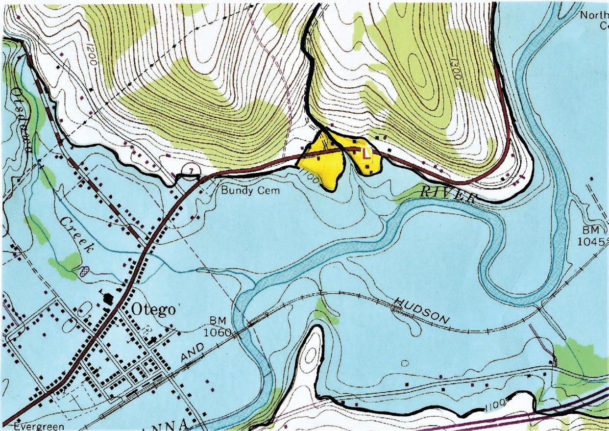
The Lundin platform (see our illustration below, yellow on map, with a red L) lay at the downhill end of a little unnamed creek flowing out of the hill above (see heavy blue line). Over time, that creek eroded through the platform, cutting it into two halves.
And then there was the elevation; that gave us a real clue. This platform reached a level of 1,100 feet (see heavy black line). We knew from earlier research that this was the level of the Ice Age lake, Glacial Lake Otego (light blue on map), that once filled the Susquehanna Valley.
Tundra Territory
Quicker than a wink from Old Saint Nick, we knew what we were looking at. The Lundin platform had been a delta in the old lake. Let’s call it the Lundin Delta.
It was as if we had traveled back in time to the centuries immediately following the end of the Ice Age. We stood at Lundins as it was back then and looked uphill. The slopes were nearly barren; there were no trees or even shrubs; the ground was covered by a primitive foliage: small plants, including grasses, sedges, mosses and lichens. This was what’s called a tundra.
Today, you would have to go to the northernmost parts of Canada to see something like this. With so little plant life to hold down the ground, that little stream was actively eroding into the hillside. It picked up and carried off great amounts of sediment, dropping them into the glacial lake and actively depositing them into the delta. The top of the delta and the lake were at the same level, 1,100 feet in elevation.
More centuries passed and millennia came and went. Glacial Lake Otego drained, and that’s when our little stream eroded the delta, cutting it into those two halves. Then the tundra was replaced by a forest of broad-leaf trees. Eventually, Christmases arrived and so did Christmas tree farms.
Enjoy your holiday.
Contact the authors at randjtitus@prodigy.net, find “The Catskill Geologist” on Facebook or visit thecatskillgeologist.com.


