6 minute read
The Gjerdrum Quick clay landslide


“The Gjerdrum landslide serves as a reminder of the power and destructive force of natural disasters and the importance of preparedness and response efforts.”
The early morning of December 30, 2020, brought a devastating event to the village of Gjerdrum, Norway, as a quick clay landslide occurred, causing widespread destruction and loss of life. The weather conditions were harsh, with temperatures dropping down to minus 22 degrees Celsius and rising up to plus 3 degrees Celsius. Quick clay is found below the marine level (the present elevation of where the sea level was at end of the last ice age) in Scandinavia. The Scandinavian peninsula (Norway and Sweden) was covered with an ice layer of about 3 000 meters (about 20 000 years ago). When the ice started to melt, the small clay particles flowed with the water and sedimented in the marine environment in salt water along the sea shore.
The salt made the clay particles form a highly unstable structure.
As the ice melted, the land formation slowly rose due to the loss of wight from the ice. Parts of the area with clay, which was situated under water, now was elevated above the sea water level.
Today the marine boarder is at about 220300 meters above sea level.
Over the years after the land elevation after the last ice age, the salt in the clay layers has been washed out due to the fresh water in the ground. When the salt, which caused the electrostatic bindings in the clay, was washed away, the strength characteristics of the clay were drastically changed.
If such clay is overloaded, the clay structure (similar to a house of cards) will suddenly collapse. Such clay is denoted as "quick". If the clay is exposed to sustained loading, is subjected to remoulding from natural causes or by man-made action, the clay masses will suddenly transform into a floating liquid in its own pore water. Quick clay slides can propagate very quickly backwards (retrogressively) over large areas, and the slide debris will float over considerable Quick clay landslides are a relatively rare but have a tragic history in Norway, with several major incidents occurring in the past century.
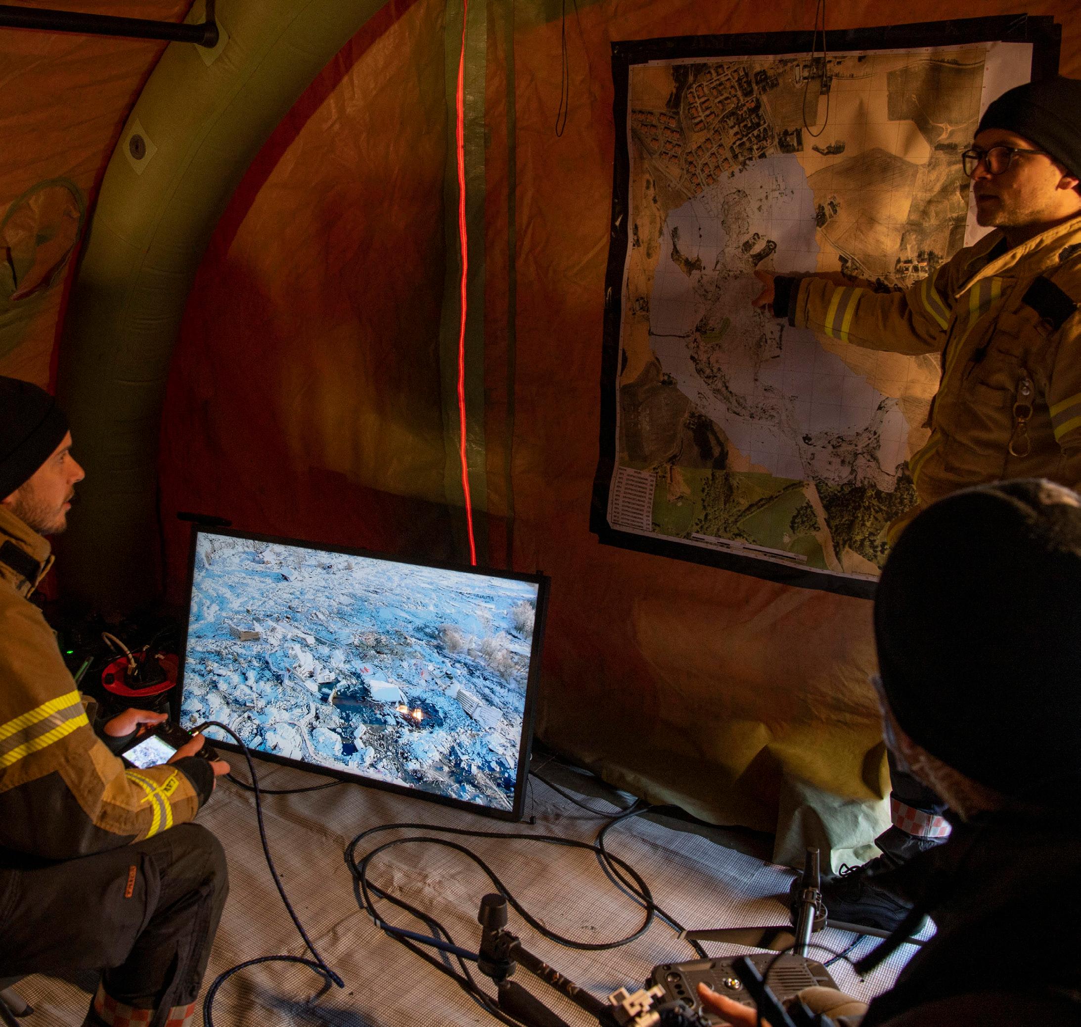
As a firefighter and drone pilot, I, Kenny Åserud, was among the first responders called to the scene of the Gjerdrum landslide. Along with the army, police, and other fire departments, we utilized drones as a tool for search and rescue operations. The use of drones proved to be a success in this disaster response operation, providing valuable information and assistance in the search for survivors and assessment of the damage.
One of the major successes of the operation was the early gathering of all drone pilots to establish better communication and planning. By coordinating our efforts, we were able to effectively survey the affected area, identify potential hazards, and search for survivors. We were careful to fly the drones at the same time as the helicopters to avoid any disturbance to the helicopter's rescue operation of people in the landslide.
The data collected by the drones in the Gjerdrum landslide provided a comprehensive understanding of the extent of the disaster and the challenges that lay ahead in the recovery process. The drones were equipped with high-resolution cameras and thermal imaging sensors, which allowed us to identify survivors and assess the structural integrity of buildings and infrastructure in the affected area. The data collected by the drones was analyzed by the drone team and shared with other emergency responders, including the army, police, and other fire departments, which helped them to make informed decisions and respond more efficiently.
The drones also provided real-time updates on the situation on the ground, which helped the command center to monitor the progress of the operation and make adjustments as needed.
The drone where used to patrol and inspect the landslide border for significant changes that were of importance to the personnel working in the landslide.
This was carefully considered with the help of a geologist and done very often to gather information on any changes. Icing on the propellers was controlled with every landing and removed carefully, icing on the propellers cause lower flight time and also weakens the drone's properties. With all the drones and helicopters being airborne at the same time, it is extremely important to talk about safety.
After some days, the Norwegian airforce came alongside a team called JTAC (Joint Terminal Attack Controller). JTAC was from NORSOF (Norwegian special forces) this team ensured the safety for all airborne units. When the operation gets as big as this landslide, it is of importance to have somebody controlling all the operations and maintaining the greater overview. Tragically, 10 people and an unborn baby died and 1,200 people were evacuated from the area. After the initial search and rescue operation for survivors, the fire department continued to use drones to evacuate the bodies. Early on, the drone team was teamed up with a geologist who interpreted the landslide at all times, which helped better understand possible incidents.
The Use of Drones in Emergency Response: A Case Study of the Gjerdrum Landslide
Introduction:
On December 30, 2020, a quick clay landslide occurred in the village of Gjerdrum, Norway, causing widespread destruction and loss of life. Emergency responders, including firefighters and drone pilots, were called to the scene to assist in the search and rescue operations. This report aims to analyze the use of drones in emergency response efforts during the Gjerdrum landslide and highlight key findings and lessons learned.
Methodology:
The report is based on an article written by a firefighter and drone pilot who participated in the response efforts of the Gjerdrum landslide. The article provides a detailed account of the use of drones in the search and rescue operations and the challenges faced during the disaster response.
Key Findings:
Drones were effectively used in search and rescue operations and provided valuable information and assistance in the search for survivors and assessment of the damage. Coordination and communication among drone pilots was crucial for the success of the operation.
Drones were used to patrol and inspect the landslide border for significant changes and gather information for the personnel working in the landslide.
The use of drones in adverse weather conditions and at the same time as helicopters presented challenges, but these were overcome with proper planning and safety measures.
The use of a geologist or other expert interpreting the data collected by drones helped make informed decisions. Safety is of the utmost importance when flying drones in emergency situations and having a dedicated team or person responsible for maintaining the overall safety of all airborne units is important. The importance of taking care of the equipment and making sure it is in optimal condition before flight, as icing on the propellers can cause lower flight time and weaken the drone's properties.
Lessons Learned:
Drones can play a vital role in emergency management and disaster response, and their use should be considered in the planning and execution of such operations.
The importance of coordination and communication among drone pilots can not be overstated. It is crucial to establish clear communication channels and protocols before an emergency situation occurs. It is important to have a geologist or other expert interpreting the data collected by drones in order to make informed decisions. Safety is of the utmost importance when flying drones in emergency situations. It is important to have a dedicated team or person responsible for maintaining the overall safety of all airborne units. The importance of taking care of the equipment and making sure it is in optimal condition before flight, as icing on the propellers can cause lower flight time and weaken the drone's properties.
Conclusion:
The Gjerdrum landslide serves as a reminder of the power and destructive force of natural disasters and the importance of preparedness and response efforts. The use of drones in emergency management and disaster response is becoming increasingly important, and the success and challenges encountered in Gjerdrum highlights the need for continued development and improvement of this technology. The use of drones in the search and rescue operations provided valuable information and assistance, and the data collected by the drones helped emergency responders to make informed decisions and respond more efficiently. The report's findings demonstrate that the coordination and communication among drone pilots, the use of a geologist or other expert interpreting the data, maintaining the equipment in optimal condition, and ensuring safety were all crucial for the success of the operation. These lessons learned can be applied to future emergency response efforts and can help save lives and minimize damage in the event of natural disasters.