
4 minute read
Castle Peak


GEToutside
the outdoors | recreation | events | mountain life
Advertisement
Castle Peak’s
MAJESTIC 360-DEGREE VIEWS
Looking up I tried to nd the castle. Someone with a better imagination Someone with a better imagination must have named this rock outcropping. While others saw turrets, I saw volcanic rock.
I have driven by Castle Peak countless times while zooming along Interstate 80 before I nally decided to climb to the top. On a clear day, you can catch glimpses of Mount Diablo, the mountain I grew up by in the San Francisco Bay Area, or Mount Lassen, the southern-most peak in the Cascade Range. e views are why you want to climb this mountain.
STORY & PHOTOS BY KATHRYN REED
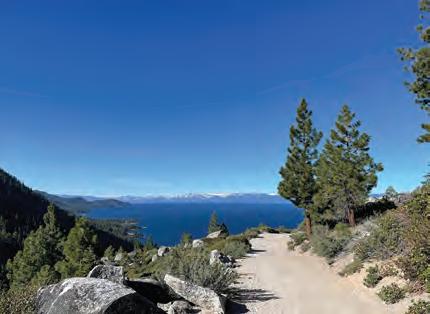
It was 360 degrees of beauty — with rugged mountains, a beautiful meadow and peaks whose names I didn’t know, nor could I fi nd them all on a map.
While the tippy top is actually 9,103 feet, we made it to 8,998 feet. My fear of heights kept me away from the turrets.
To the north was the distinctive Sierra Buttes. Turning to the east was Stampede Reservoir. e nearest iconic xture were the slopes of Boreal ski resort. It was 360 degrees of beauty — with rugged mountains, a beautiful meadow and peaks whose names I didn’t know nor could I

THE TRAIL
Dogs OK; carry water | Poles recommended
6.43 miles RT | Moderate Elevation gain | 1,737 feet
nd them all on a map. Plenty of people were enjoying the scenery and having a bite to eat before heading back; it was a respectful group — no loud chatter, no obnoxious cell phone calling which has been my experience at other times in the Sierra.
We started our adventure at the gate just o the interstate, though it would be possible to drive the better part of the way to the top. e reason to drive would be to access other trails without having to hike as far. We ended up doing a loop instead of an out and back. e loop was a bit shorter because the route we took back was more direct. We clocked 6.43 miles total.
From the gate where you park there is a choice to go left or right. Go right. is would also be the dirt road (Castle Valley Road) you could drive on; four-wheel-drive vehicles are recommended. Not too far up there will be a fork in the road with a sign signaling right for Donner Lake Rim Trail. Follow this for the more scenic route. Straight ahead is the route we came down and the one you would want to drive in order to park as close as possible. You will

TOP TO BOTTOM: Part of the trail includes a dense forest; A couple enjoys the view from Castle Peak; While some see turrets on a castle, others only see rock formations.
hit another juncture, Castle Pass, where you will go right.
Once on the singletrack and o the dirt road the terrain changes dramatically. Trees are closer together with patches of mule’s ears moving in the gentle breeze. At certain points the view to the west opened up.
Part of the route is along the Paci c Crest Trail (note: mountain bikers are not allowed on the PCT). All but about the last mile is relatively easy or moderate as far as Tahoe area hikes go. It’s the steepness at the end that will have you slow your pace. Coming down it was the scree on the path that made me so thankful to have poles.
Directions | From Truckee, go west on Interstate 80. Take the Castle Peak/Boreal exit and go right. Park before the gate but do not block it.
SUBMIT YOUR EVENTS FOR FREE
Visit TheTahoeWeekly.com to add your Event for our print & online calendars.
Click on Events; then the blue Add Event button.
Fund Flume Trail reroute
The loose, sandy descent at the end of the East Shore’s Flume Trail has long been an issue for mountain bikers and hikers, and to relieve the pressure and create a safer, more enjoyable experience, Tahoe Fund is launching a fundraising campaign to build a new singletrack trail adjacent to the road. Every dollar donated will be matched by the Spaht Family until the campaign goal of $50,000 is reached.
Once built, the Tunnel Creek Singletrack will be a 2.3-mile, multi-use trail that provides users with a less stressful alternative when descending from the Marlette Flume Trail, the Incline Flume Trail and the Tahoe Rim Trail. Expected to be completed in two phases, Phase 1 construction can begin later this summer once the funds are raised.
Tahoe Fund aims to raise $50,000 to complete construction of Phase 1 and to provide funding to secure the next grant needed for Phase 2. | tahoefund.org
Tahoe Science Center reopens
The Tahoe Science Center has reopened for one-hour tours for the summer by advance reservation only. Visitors will enjoy several new exhibits including “Tahoe’s Plastic Problem” exhibit and new baby Lahontan Cutthroat Trout are in residence in the fi sh tank of the interactive laboratory exhibit.
All visitors are required to purchase tickets online for timed-entry at least 24 hours in advance. Tickets are available to reserve in up to two weeks in advance. Visitors must complete a Daily Symptom Survey before entering. | Reservations tahoe.ucdavis.edu


