6 minute read
Sightseeing


TheTahoeWeekly.com
GEToutside
Advertisement
the outdoors recreation events mountain life
Twin Lakes MESMERIZING VIEWS ALONG TRAIL BETTER THAN DESTINATION
he trek to Twin Lakes in Spooner Backcountry on the East Shore of T Lake Tahoe is one where the journey is more beautiful than the destination. It’s is a rarity when an alpine lake doesn’t capture all the oohs and ahhs.
Twin Lakes is just o the Tahoe Rim Trail near a junction that is popular with hikers and mountain bikers. With how low the water level was on my visit it would be possible to not even notice the lake. e expanse of dirt and grass had the dry lake bed being a larger mass than where the water was. From our vantage point we only saw one of the lakes.
STORY & PHOTOS BY KATHRYN REED

“I think the issue of wet some years and dry for other years is due to a relatively small watershed,” says Jay Howard, former park supervisor for Lake Tahoe Nevada State Park. “ ey are also small bodies of water that are greatly subject to evaporation. When evaporation exceeds the amount of water coming in from snowmelt, a pretty fast drawdown can occur. I don’t know for sure but I don’t believe those lakes have any groundwater or springs entering from below. Over the years that I’ve noticed, the fact that they have water has seemed to be tied to snowpack — heavy or at least average snowpack years, they have water — dry or below average snowpack years, they tend to have so little water that they dry very quickly. And yes, they are unusual due to their high location.”
THE TRAIL
Dogs on lease OK.
9 miles roundtrip | Moderate Elevation gain | 1,689 feet
ese lakes, such as they are, are at almost 8,000 feet. One guy the four of us passed said in 30 years of hiking the area he had never seen water in the lakes.
A eld of granite boulders seemed to be sprouting from either side of the lake. ey were round, not jagged and rough like so many in the Sierra. is must be from being under water at times.
6
e sign near the start of the trailhead in Incline Village says Twin Lakes is 3.8 miles. ree of us recorded a round trip of 9 miles from the base of the road. e parks department might want to redo its signs with the correct mileage. Better signage where the road meets the Tahoe Rim Trail would be appreciated, as well. Twin Lakes is not on any of the signs up there. Had we gone left, we would have been headed toward the Mount Rose/ Tahoe Meadows trailhead of the TRT, while going straight would have had us going downhill on the Red House Flume Trail toward Hobart Reservoir. We took a right toward Spooner Summit, which was less than 1 mile to the lakes.
Most of our route was Tunnel Creek Road, which to cyclists is better known as the Flume Trail. While we were going up, most on two wheels were coming down. is is an old dirt road, so it’s wide enough for various recreation users and good for social distancing. Still, it was up the entire way and at times seemed a bit steep, especially for the two who had been living at sea level until a week before the hike. at steepness, though, didn’t present a problem coming down.
A couple spots along the route Tunnel Creek could be heard and seen. is would be a welcome relief for four-legged hikers, especially with much of the trail being exposed and not shaded. e openness was perfect for picture taking — water and mountains. Lake Tahoe in several locations
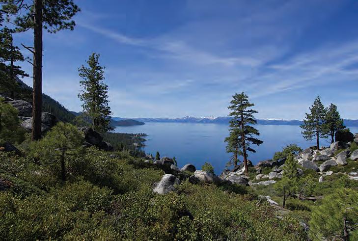
CLOCKWISE FROM TOP: Lake Tahoe is prominent along much of the lower section of the trail; An aspen grove along the trail, which mostly an old logging road, will be even more colorful in the fall; Not much water in Twin Lakes along the Tahoe Rim Trail on the East Shore.

was breathtaking with its grandeur. e curvy shoreline o ered a de nition not often seen from Tahoe trails with some shallow areas mesmerizing because of the emerald hue.
Much history is stored in this section of the Sierra. A set of umes were designed to take water from the area, through the Washoe Valley on the other side of the mountain, to Virginia City, Nev., where it was used in the silver mines in the late 1800s. A tunnel on the Tahoe side was used to transport water and lumber in a V-shaped ume. at wood was needed to build the mine shafts. A few informational signs are posted near the start of the trail. One reads, “ e Marlette Lake water system was nominated for the National Register of Historic Places in 1979 and was listed as a Historical District in 1992. e system has been upgraded and is still used today to supply Virginia [City] and Carson City with water.”
Today, the water system is owned by the state of Nevada. e trail begins at Tunnel Creek in Incline Village. Park at the East Shore Trail Parking Lot and walk up Tunnel Creek Road. ere is a $2 fee per person to enter Lake Tahoe Nevada State Park. It’s an honor system; do the right thing and support the local parks. Dogs on lease OK.
Peregrine Falcons are Doing Better
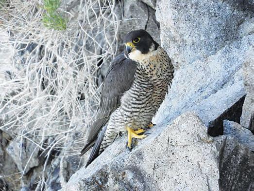
Lake Tahoe organizations working to harmonize wildlife protection and responsible recreation reported a successful effort to protect fl edgling peregrine falcons while still allowing access to popular hiking and climbing routes near the birds’ nesting sites. For the second year in a row, young peregrine falcons successfully left their nest at Castle Rock, it was announced in a press release.
The success of the nest is being attributed to a collaboration between Forest Service Lake Tahoe Basin Management Unit, Tahoe Regional Planning Agency, Nevada Department of Wildlife, California Tahoe Conservancy, Tahoe Institute for Natural Science, Sierra Ecotone Solutions, Tahoe Climbing Coalition and Tahoe Rim Trail Association to educate climbers and hikers about their impact. Peregrine falcons have been monitored as a special interest species dating back to 2009.
Over the years of monitoring, falcon populations increased and expanded to new areas of the Tahoe Basin such as Castle Rock, also a popular location for rock climbers and hikers. The partners worked together to educate climbers and hikers, temporary trail closures, posted signs when the birds were nesting and monitoring the nests.
“Lifting the closure once it’s no longer needed each year gains the confi dence of the hikers and climbers using the area, building trust that these voluntary closures are not arbitrary, which in turn leads to better compliance and better outcomes for the birds,” said Will Richardson, executive director of Tahoe Institute for Natural Science, in the release. “This was the fi rst year they raised triplets.”


