5 minute read
Pajaro River Levee Project Crosses Milestone, By Zach Friend, Super
FEATURED COLUMNIST
Pajaro River Levee Project Crosses Milestone
Advertisement
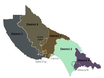
By Zach Friend, Supervisor, Second District
Over the past 70 years, the communities of Watsonville and Pajaro have lived under the shadow of inadequate flood protection from the levees that protect homes and property along the Pajaro River and tributaries. The existing levees that protect the communities were built in 1949 and have not been significantly improved since.
Today, these levees provide only an 8-year level of flood protection, believed to provide the lowest of any federal flood control system in California and one of the lowest in the United States.
However, in the last year significant progress has been made to bring the levee rebuild project toward reality — including a major milestone that just recently occurred — passage of a local assessment for ongoing operations and maintenance.
This step, allows for the activation of a historic level of state and federal funding ($400 million) that has been committed to rebuild the levees. As part of the funding requirements, however, the local community must promise to maintain levees to strict federal regulations. The cost of the ongoing operations and maintenance is about $1.2 million annually.
Property owners near the levee were asked to support an assessment to fund this ongoing operations and maintenance and nearly 80 percent voted in favor - ensuring this unlocking of the historic state and federal investments.
What Is The Proposed Project?
The federal flood management project, sponsored by the U.S. Army Corps of Engineers, will provide a 100-year flood protection to Watsonville and Pajaro and a mix of 100-year and 25-year flood protection to some of the other surrounding agricultural areas in Santa Cruz and Monterey counties). Per capita income in these communities is less than half the state and national averages. This project will provide significant life and economic safety improvements to both counties and even eliminate flood insurance costs for those within the FEMA Special Flood Hazard Area.
What Is The Project Cost?
The $400 million project will include construction of levees and improvements, toinclude setback levees, along the lower Pajaro River and its tributaries. It will be managed by the U.S. Army Corps of Engineers in partnership with the Pajaro Regional Flood Management Agency and the CA Department of Water Resources.
How Will The Project Be Funded?


Funding such a costly project has been one of the largest challenges. However, in the last year we have worked extensively with our state and federal partners on ways to position the project for funding — with innumerable meetings with the White House, Congress, Army Corps and state legislative leaders. In the past year, our area has received historic investments from the state and federal level — and as noted above — a local assessment that helps put the project on track to construction.
These federal projects have cost-share requirements with local communities — in this case the federal government would pay 65 percent and the local community 35 percent.
The State of California agreed to fund 100 percent of the local cost share — up to $181 million of project costs. According to conversations with the Army Corps and White House, our community is the only in the country to have the state commit to such funding.
Additionally, the White House announced that they have put $67 million of federal funding into the project as part of the Administration’s infrastructure funding that they are focusing on environmental and social justice projects.
Approximately $5 million in additional funding has already been provided by the Army Corps as part of the planning and design process. Additional federal funding is expected as the phases of the project are built — equating to the 65 percent total federal cost share. The local ongoing operations and maintenance ($1.2 million) will be raised through the recentlyapproved assessment.
What Is The Status Of The Project?
Work has begun in earnest to set the stage for levee reconstruction. The Army Corps and local sponsors have begun the pre-construction engineering and design phase. The Corps started initial work that will support design sections along the Corralitos and Salsipuedes Creek corridor. The Army Corps awarded a contract to an engineering firm to develop the designs and specifications for the flood control facilities to be built along this portion of the project.
Initial work in support of design includes geotechnical subsurface investigation and subsurface data collection. This work began in late spring — which included collecting nearly 200 rights-ofentry throughout the project footprint along the Corralitos and Salsipuedes Creek corridor.
A secondary contract was awarded by the Corps to conduct topographic surveying within these areas in support of design. Cultural and environmental survey work will begin this summer to support project design and State Historic Preservation Office and Tribal coordination requirements, and to update the Project’s Programmatic Agreement. It is expected that initial design for these sections (35% plans and specifications) will be completed this fall.
How Can You Learn More?
With the approval of the assessment, a new Community Assessment Oversight Committee to represent the interests of property owners in the expenditure of assessment revenues will be created. The Committee would review financial reports, annual audit documents, and annual budget proposals and report back to the community on its findings. If you are interested in serving on this committee, or want to learn more about the project in general, check out the PRFMA website at https:// www.prfma.org — or you can always contact me below. n •••
As always, I appreciate any feedback you may have on this (or any other County issue). I’m maintaining regular updates on social media at www.facebook.com/supervisorfriend and you can always call me at 454-2200.


SPECIALTY SCREEN & GLASS SHOP
Local Local Local Local News ... Sports ... News ... Sports ... LocalLocal PoliticsPolitics ......


