7 minute read
in 2021


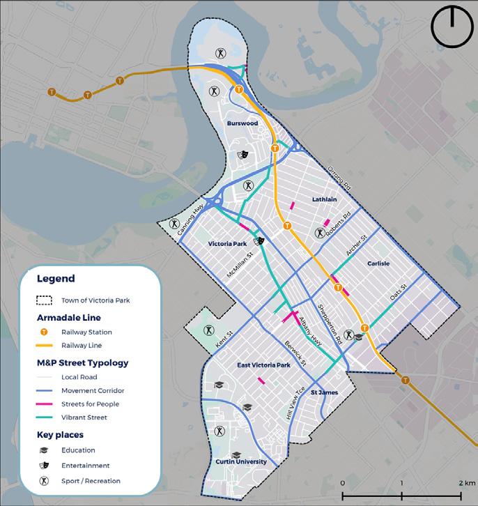
Figure 5.9: Future Movement and Place Classification
5.3.1 Design Guidance
Advertisement
The Movement and place assessment has identified a number of locations where the existing street typology is required to service a different movement and/or place function in the future. To enable this, the Town is required to implement movement and/or place improvements to these streets. This will ensure that the Town’s street network reflects the movement and place function identified within the future Movement and Place assessment. To achieve this, Table 5.1 outlines clear design guidance for each of the four street typologies. This guidance should provide the basis for implementation of the future Movement and Place network. However, when developing a design for these streets, additional consideration should be given to the local context of each individual to ensure a bespoke design response.
Table 5.1: Movement and Place Design Guidance
STREET TYPOLOGY POTENTIAL TRANSPORT RELATED DESIGN RESPONSES
Local Roads
• Low vehicle speeds and traffic volumes; • Footpaths on at least one side of the road; • Extensive use of local area traffic management treatments; • Skinny streets; • Minimal kerb radii at intersections to encourage vehicle traffic to slow down when turning into side streets; • Shared space environments; • Active frontages; and • Extensive tree canopy coverage creating a comfortable pedestrian environment.
Movement Corridors • Wider lanes facilitating higher vehicle speeds; • Dedicated turning pockets at major intersections; • Clear sightlines for all road users; • Bus/transit priority infrastructure on key transit routes; • Wide footpaths that facilitate safe and convenient access to public transport stops; • Cycling infrastructure that is physically separated from motorised traffic; and • Provision of safe pedestrian and cyclist crossing points at key locations.
STREET TYPOLOGY POTENTIAL TRANSPORT RELATED DESIGN RESPONSES
Streets for People • Low vehicles speeds and traffic volumes, • Pedestrian priority, including potential use of continuous footpath treatments across driveways and side roads; • Ample areas to dwell with street furniture and active frontage to buildings on at least one side of the street space/plaza; • Extensive tree canopy coverage creating a comfortable pedestrian environment; • Provision of a transition zone between the ‘Street for people’ and higher movement streets using on-street vehicle parking and/or landscaping measures; and • Good pedestrian connections to the broader pedestrian, cycling, transit and road network.
Vibrant Streets • Traffic calming promoting low vehicle speeds; • Separated cycling infrastructure; • Wide pedestrian footpaths / sidewalks with activated frontages on both sides of the street; • Reliable bus services with potential bus priority measures at signalised intersections or on-road bus priority lanes; • Bus stop facilities including timetable, seating, shelter, rubbish bin and real time information (when implemented in the future); • Extensive tree canopy coverage creating a comfortable pedestrian environment; • Convenient bicycle parking outside businesses and other points of interest; • Street furniture and pockets of urban greenery providing opportunities for visitors to dwell; • Minimal kerb radii at intersections to encourage vehicle traffic to slow down when turning into side streets; • Bicycle parking along the street; • Implementation of CPTED measures; and • Provision of on-street parking between moving vehicles and pedestrians, with on-street parking managed by time-restrictions.
5.4 Challenges and Opportunities
The Town not only aspires to improve transport efficiency, but also improve journey experience and promote the uptake of active and sustainable transport modes. The aim of this is to increase sustainability, supporting a more healthy, accessible and liveable Town.
Transport challenges and opportunities have been identified through an understanding of the place-based context analysis presented within this Chapter. This analysis has drawn upon a range of data sources including site observations, community and stakeholder engagement outcomes, ABS Census data, transport network patronage data, accessibility based analysis and a Movement and Place assessment.
As an outcome of this analysis, the following table provides a summary of the Town’s transport challenges and opportunities which have informed the development of the vision and objectives of the Town’s transport network.
Table 5.2: Overview of Transport Challenges and Opportunities
THEMES CHALLENGES
Walking • Disconnected footpath network, lack of lighting and wayfinding in some areas throughout the town pose a challenge for walkability. • Lack of canopy coverage in some locations creating a hostile walking environment. • High speed and trafficked roads as well as the rail line creating barriers to walkability within the Town. • Poor pedestrian connectivity from Curtin University to surrounding residential areas. • Walking is the most common method of transport for 11% of survey respondents and 38% of respondents travel somewhere daily by walking, and 50% travel somewhere at least once a week by walking. • There are a number of key destinations and local centres which are in walking distance of residential areas throughout the Town. • Albany Highway is located in an opportunist location creating a town centre spine down the middle of the Town. • Improve amenity through the provision of shade and lighting on local streets, as identified in the community engagement survey. • Revitalise street environments to create streets for people that favour pedestrians, increase opportunities for businesses and enhance sense of community. • Implementation of the Town’s Streetscape
Improvement Program will deliver improved pedestrian environments in key locations.
OPPORTUNTIES
THEMES CHALLENGES
Cycling • Absence of protected or dedicated cycling infrastructure throughout the Town, especially to key destinations. • Substandard to absent endof-trip facilities at work places within the Town deterring people from cycling to their place of work. • Lack of separated pedestrian and cyclist infrastructure throughout the Town creating opportunities for conflicts. • Absence of a completed Principal Shared Path along the Armadale rail line. • Difficulties in crossing high speed and trafficked roads. • Absence of secure bicycle parking at key destinations within the Town deterring people from cycling to their destination. • The Town’s community are interested in cycling with the community engagement findings demonstrating that cycling is the second most common method of transport (20%) and 32% of survey respondents noted that they cycle at least once a week. • Cycling presents an attractive mode to access activity centres and key destinations located within the town. • Established recreational shared path cycling network along the Swan River foreshore. • Cycling can be combined with other transport modes to create multimodal journeys, which can be further enhanced through the provision of end-of-trip facilities. • The emergence of e-bikes and other forms of micro-mobility creates more opportunities, overcoming the barriers of exercising before work and making topography less of a challenge. • Implementation of the Skinny Streets program to improve attractiveness of cycling on local streets within the Town. • Implementation of bike boulevards to improve cycling for all ages and abilities.
OPPORTUNTIES THEMES CHALLENGES
Public Transport
• Community perception of safety and security on public transport throughout the
Town. • Lack of bus service provision and frequency in the nighttime, creating a challenge for the Town’s night time economy. • Lack of bus priority and prevalence of road connection on key movement corridors creates bus service delays. • Unreliable bus services due to road congestion and lack of priority on the road network. • Planning and the operation of public transport services is not the responsibility of the
Town. • The Level Crossing Removal Project as well as
Burswood Station redevelopment project within the Town will see the redevelopment of Carlisle and Oats Street Stations as well as revitalised station precincts and new station access infrastructure. • Frequent bus services to the Perth CBD and key locations within the Town such as Curtin
University. • Potential for a mid-tier public transport system within the Town to complement and support the existing network. • The use of emerging technologies, including zero-emission buses, accurate real time bus location data, and permitting the use of forms of micro-mobility to improve connectivity. • Opportunity to explore the provision of a CAT bus service or similar as identified through community engagement. • Opportunity to improve access to public transport stops and interchanges to improve overall journeys.
Driving & Parking
• Driving remains the most popular mode of transport in the Town, making up 52% of survey respondents most common mode of transport and 62% of all journeys to work in 2016, increasing marginally from the 2011
Census. • Vehicle ownership rates have also risen from 43% of households owning more than two motor vehicles in 2011 to 46% in 2016 (ABS 2016). • Rat running of through trips creating congestion and safety issues on the Town’s local road network. • Large provision of parking in areas of high place value and high activity such as within activity centres. • Encourage mode shift from private vehicle to more active and sustainable modes for short trips within the Town. • The implementation of planning for electric vehicles (EVs) to ensure the Town can cater for their growing use. • Draw upon various methods including existing and emerging technologies for managing parking demand in the Town’s activity centres. • Implementation of Skinny Streets program to improve road safety for all users and encourage mode shift. • Frequently host car-free event days within the Town to demonstrate benefits of reduced vehicles on the network.
OPPORTUNTIES
#LOVEVICPARK

victoriapark.wa.gov.au


