Detailed Business Case


HELLS GATES DAM & IRRIGATION SCHEME
TECHNICAL EXPERT SUPPORT Economic impact modelling and financial analysis undertaken by KPMG

Document: Detailed Business Case
Project Name: Hells Gates Dam and Irrigation Scheme
Project Number: 30033330
Revision Number: 4 (Final)
REVISION NO. DATE
1.0 December 2021
2.0 January 2022
BY
N.Mincher, T.Martin, L. Beyleveld, R.Powlett, O.Falkiner, J.Grocott, J.Thompson, M.Malakellis, B. Aoukar, S.Baird, R.Poole, K.Narayan, C.Wiltshire, T.McCauley, G.Lush, E.O’Brien, I.Varley
N.Mincher, T.Martin, L. Beyleveld, R.Powlett, O.Falkiner, J.Grocott, J.Thompson, M.Malakellis, B. Aouker, R.Poole, K.Narayan, C.Wiltshire, T.McCauley, G.Lush, E.O’Brien, I.Varley
3.0 April 2022
N.Mincher, T.Martin, K.Narayan, L. Beyleveld, R.Poole, O.Falkiner, J.Thompson, B. Aoukar, J.Grocott, M.Malakellis, S.Baird
BY
D.Cook K.Narayan G.Pollock K.Narayan
BY
4.0 May 2022
N.Mincher, T.Martin, K.Narayan, L. Beyleveld, R.Poole, O.Falkiner, J.Thompson, B. Aoukar, J.Grocott, M.Malakellis, S.Baird
K.Narayan K.Narayan
K.Narayan G.Pollock C.Brumme Smith T.Holmes D.Halfpenny
K.Narayan G.Pollock C.Brumme Smith T.Holmes D.Halfpenny
K.Narayan
K.Narayan
PROJECT MANAGER: KRIS NARAYAN
Address: Level One, 313 335 Flinders St, Townsville City, QLD, 4810, Australia

Approved: Tel: +61 7 4729 6727 Fax: +61 7 3029 6650 Email: Kris.Narayan@smec.com Website: www.smec.com
The information within this document is and shall remain the property of SMEC Australia Pty Ltd and Townsville Enterprise Limited and written approval shall be sought prior to distribution outside the aforementioned parties.
This report is confidential and is provided solely for the purposes of information only for the engagement of the contract. This report is strictly limited to the matters stated in it and subject to the various assumptions, qualifications and limitations in it and does not apply by implication to other matters. SMEC makes no representation that the scope, assumptions, qualifications and exclusions set out in this report to be suitable or sufficient for other purposes nor that the content of the report covers all matters which you may regard as material for your purposes.
This Report supersedes all previous draft or interim reports, whether written or presented orally, before the date of this report. This report has not and will not be updated for events or transactions occurring after the date of the report or any other matters which might have a material effect on its contents or which come to light after the date of the report. SMEC is not obliged to inform you of any such event, transaction or matter nor to update the report for anything that occurs, or of which SMEC becomes aware, after the date of this report.

The Hells Gates Dam and Irrigation Scheme (the project) presents a transformational economic development for Northern Australia, comprising of a unique agricultural project, that will double the value of crop production regionally utilising world leading land management and high tech agriculture practises.
The scheme’s irrigation farming lands present a unique opportunity for the optimal use of currently unused water allocations within the vast Burdekin catchment if both dams (and indeed the new Big Rocks Weir) were operated as a combined system. This would assist in minimising environmental flow impacts and maximising water supply reliability for both new and existing water allocation holders.
The project is a large employment generator, both during construction and once operational, and is able to build on existing transport and supply chains. The recommended Reference Project (60,000 hectares):
• comprises a 2,100 GL dam and three weirs, enabling 60,000 hectares of irrigated agriculture
• offers scalable opportunities for both the dam and the irrigation schemes
• will deliver a state of the art scheme, building on the learnings from previous irrigation scheme developments
• prioritises sustainable agricultural production and environmental sustainability, including for the lower Burdekin catchment and the Great Barrier Reef
• enables reliable and dependable water supply to a mixed cropping agricultural development with a combination of perennials, annuals and broadacre cropping to meet national and global demand
• provides for the production of renewable energy through the dam’s Toe of Dam hydropower (hydroelectric) scheme located at the base of the dam
The sheer scale of land and reliable water supply has been identified by irrigation farming investors as a highly attractive proposition, relative to other existing irrigation schemes.
It provides a rare opportunity to expand the North Queensland economy with enormous flow on benefits to Townsville and adjacent regions, as well as representing a significant new agricultural development at the state and national level.
The project delivers on State and Federal Government economic policy priorities, including the objectives of the White Paper on Developing Northern Australia (2015) that outlined the Australian Government’s vision for the future of Northern Australia. The project also aligns with key strategic policy documents such as the Australian Agriculture’s Plan for a $100 Billion Industry. Currently, national agricultural production is $71.2 billion, with a target of an additional $28.8 billion over the next eight years, meaning to reach the target, the rate of value growth needs to more than double the current production rates (1.9% to 4.7%).
The project has been proposed in various forms for over 80 years, with the Hells Gates Dam Feasibility Study, delivered by Townsville Enterprise Limited in 2018, consolidating the foundation for this Detailed Business Case.
• brings together detailed technical studies and is aligned to Queensland Government business case frameworks
• presents a strong case for further development of the project, whilst recognising additional studies, negotiations and approvals are required before construction can proceed
• confirms the Reference Project, with stress testing this preferred option, to conclude whether it should proceed for further development and, if so, identify the key issues to be resolved.
The primary service need is to secure water allocation and supply in the Upper Burdekin, to support high value irrigated agricultural and horticultural production. This has direct and indirect flow on benefits, providing long term secure employment in the region.
Investing in water access in the region is particularly attractive due to the availability of large tracts of highly productive agricultural land and favourable climatic and other environmental conditions.
The agricultural land is suitable for a suite of annual horticulture, perennial horticulture and broadacre crops, for which market assessments demonstrated strong demand for the various crop types.
Assessment of market demand supports the findings that:
• the project presents the opportunity to transition to higher value agricultural and horticultural production whilst maintaining grazing activities in the northern Burdekin region
• existing grazing landholders and a range of irrigation farmers and investors have been surveyed as part of the demand studies. The capital required to develop the scheme will most likely come through investment partnerships between existing or new landholders, banks and equity funds
• broad consensus from corporate agriculture companies that the project would be an attractive investment proposition with favourable project characteristics
• irrigators/investors are also assumed to have the capacity to contribute approximately 25% of the required capital funding
Based on these studies the Detailed Business Case assumes there is sufficient demand for the full 60,000 hectares of irrigated farming and the full use of any available water allocations.
Engagement and consultation with Traditional Owners has been an important component of the Detailed Business Case, including the development of a framework for cultural heritage engagement that was presented to the North Queensland Land Council on behalf of Gugu Badhun and Ngrragoonda Aboriginal Corporations. Both Corporations have expressed concerns with the project due to the loss of heritage expected for the area and both groups have set out a number of expectations to be considered for engagement through all future project stages. The project must not only address agricultural and economic development related service needs but also the needs of the Traditional Owners.
The Reference Project will double the value of crop production regionally, resulting in the Burdekin Basin becoming the largest regional contributor to Queensland’s non livestock agricultural output, and account for an additional 3% of the total national annual crop production. This is truly a national building project.
In addition, the Reference Project will result in:
• economic benefits, including:
a Benefit Cost Ratio of 1.05 for the full size scheme under the Reference Project, with sensitivity cases tested, including for higher capital costs, which still estimated a Benefit Cost Ratio of approximately 0.9 an economic contribution showing major positive impacts for regional, State and national economies including increased Gross Regional Product and employment of $6 billion and 3,300 new jobs, respectively.
• financial benefits, including both costs and project revenues based on prepared demand studies and forecasts, including:
a cost of constructing the scheme estimated at $7.257 billion (in nominal dollars) an Internal Rate of Return (IRR) of 3.27%.
Development of the 60,000 hectare agricultural scheme has wider regional benefits to the supply chain and supporting service industries. Additionally, the Hells Gates Dam and Irrigation Scheme will address the current decline in population in regional areas by supporting future manufacturing and secondary processing, which will subsequently promote more jobs and skills enhancement in the region.
At an operational level, improved water resource management outcomes for the Burdekin Basin would be achieved if the project and the existing Burdekin Falls Dam were operated as a combined system. This would enhance water security for the Burdekin Falls Dam during low rainfall periods, while still allowing high flow events which are critical to the health of the coastal ecosystems (including the Great Barrier Reef) to be passed through the system.
The project also presents environmental benefits and opportunities, including:
• reduced sediment influx to the Burdekin River due to improved, world leading irrigated land management practices
• expanding irrigated agriculture in the upper (rather than lower) reaches of the Burdekin Basin, providing additional buffering capacity against pollutant export to the Great Barrier Reef
• establishing irrigated agriculture in a portion of the Burdekin Basin which is significantly less susceptible to groundwater level increases and consequent secondary salinity.
To achieve the above benefits from managing the fourth largest river basin in Australia, the Burdekin River would operate holistically as a conjunctive river system, and it is likely that the State Government will own and operate the Hells Gates Dam.
The Hells Gates Dam and Irrigation Scheme is of a scale which requires investment towards land and water infrastructures well beyond the existing agricultural producers in the immediate surrounding area. It is also likely to require capital investment from existing agricultural institutions from elsewhere in Queensland and interstate, who are seeking to increase and/or diversify their businesses through large scale agricultural development
These entities are, collectively, assumed to generate the demand for the land and water entitlement offerings that would be put to the market once there is greater certainty that the project will be progressed.
The model proposed is based on seeking binding contractual commitments from these entities to purchase the land and water assumed, at this stage, to mirror other southern irrigation developments, with financial contributions in tranches of 2%, 8% and 90% as described elsewhere in this Detailed Business Case
To undertake a preliminary market assessment of the appetite for these investments, direct market demand research was undertaken with existing landholders and twenty of Australia’s largest agriculture investment firms, noting there is an element of work required as part of the pre construction phase of the project through the series of gates presented to critically de risk the project development ahead of non binding and binding commitments.
Key features of the project that were identified as favourable by entities surveyed included the following:
• the greenfield nature of the scheme with abundant water and land available for development
• favourable cropping conditions and proximity to transport and other required infrastructure
• the contemporary scheme design, including the mechanisms to deliver the water from bulk source to farm
• competitive water prices for a scheme of this size (compared to other irrigation schemes nationally), both the upfront cost of purchasing water entitlements and ongoing water charges once scheme operations commenced.
These demand surveys and follow up consultations, which include recent Expressions of Interest (responses are attached in Appendix F) built on detailed market research and on farm profitability studies undertaken for the project. Of the investors consulted, 100% stated that the proposed water price (annual and ongoing) is both competitive and acceptable to the market.
The conclusion was that there is sufficient potential demand for land and water offerings from the large scheme (circa 60,000 hectares and 549,652 ML/annum) to assume in the financial modelling that:
• approximately 25% of the capital costs for the Reference Project would be able to be funded by irrigators and investors
• the ongoing water charges were competitive, relative to other projects and investment offerings.
Two main sources of project funding are identified:
• private irrigators/investors $1.7 billion (nominal)
• Australian Government $5.4 billion (nominal).
In March 2022 and subsequently in its 2022 23 Budget, the Australian Government committed that it will:
“Provide $5.4 billion for the Hells Gates Dam on Queensland’s Burdekin River. This transformational project will redefine North and Central Queensland’s agricultural sector and underpin long term export market growth and investment. The Government is also providing $1.7 billion for agricultural and industry development in this region to help farmers and businesses fully harness the opportunity that the Hells Gates Dam offers.”
The Great Barrier Reef is under increasing pressure from a range of threats including climate change and land based runoff. In June 2021, the United Nations Educational, Scientific and Cultural Organization (UNESCO)
recommended that the Great Barrier Reef be declared World Heritage ‘in Danger’. The Commonwealth and Queensland Governments developed the Reef 2050 Long Term Sustainability Plan (Reef 2050 Plan) to provide an overarching framework to protect and manage the Great Barrier Reef to 2050. Under the Reef 2050 Plan, the Reef 2050 Water Quality Improvement Plan 2017 2022 seeks to improve the quality of water flowing from the catchments adjacent to the Great Barrier Reef. It addresses all land based sources of water pollution including run off from urban, industrial and public lands but recognises that the majority of pollution comes from agricultural activities.
The Hells Gates Dam and Irrigation Scheme presents positive Great Barrier Reef outcomes due to the following key features:
• The Hells Gates Dam and Irrigation Scheme will reduce sediment and nutrient loads delivered to the downstream Burdekin Falls Dam due to world leading land management and agricultural practices within the project area (e.g. buffer strips along waterways, recycle pits, controlled nutrient application, capturing runoff for re use, compliance with the Reef Regulations), and water take by the scheme and evaporation from the dam. Current land practice is dominated by grazing and there is extensive gully erosion, which is delivering large volumes of sediment and associated particulate nutrients into the Burdekin River and Burdekin Falls Dam.
• Expanding irrigated agriculture in the upper (rather than lower) parts of the Burdekin Basin, will provide additional system buffering capacity against pollutant export to the Great Barrier Reef. The large water volume of Lake Dalrymple provides a buffering affect as the holding time in the lake allows for sediments (and associated particulate nutrients) to settle out of suspension before being released to the lower Burdekin River and the Great Barrier Reef. There is limited buffering of pollutant runoff from sugar cane areas of the Lower Burdekin, which flow into coastal ecosystems and the Great Barrier Reef Marine Park via surface and groundwater.
• In the Lower Burdekin area, high rates of fertiliser application and large losses of irrigation water to waterways, wetlands and coastal ecosystems can significantly impact ecosystem health and function such as nutrient enrichment, water oxygen depletion and fish kills. Rising water tables are also evident in the Lower Burdekin irrigation areas, which can lead to water logging, increased salinity in the root zone and altered productivity.
• The Hells Gates Dam and Irrigation Scheme provides the opportunity to establish best practice innovative technology in the irrigation scheme, land and water management in the Burdekin Basin, which would reduce sediment and nutrient loads flowing to the coastal ecosystems and the Great Barrier Reef. The Upper Burdekin is also significantly less susceptible to groundwater level increases and consequent secondary salinity, which is currently an issue in the Lower Burdekin area.
• Given the scientific rigor and stringent legislative requirements associated with the Reef 2050 Plan and management of the Great Barrier Reef, the Hells Gates Dam and Irrigation Scheme has been developed with
world leading water and land management practices to enable the safeguarding of the world heritage listed Great Barrier Reef
To successfully realise the forecasted benefits and opportunities for the project, several critical issues will need to be resolved as part of any subsequent detailed pre construction and Environmental Impact Statement phase.
The sourcing of up to 550,000 ML of new water allocations that are not contemplated or provided for within the current Water Plan (Burdekin Basin) 2007 is a key issue to be resolved. It will be critical for this project that the revised Burdekin Water plan includes this project as part of the next revision.
Identified pathways for addressing this challenge include various combinations of the following water allocation strategies, with multiple options providing heightened opportunity for the sourcing of the necessary water entitlements to be advanced:
creating a new additional unallocated strategic water reserve for the project reassigning some (or all) of the existing unallocated water reserves to the project
acquiring and moving/reconfiguring/converting existing water entitlements that are located within the Burdekin Haughton Water Supply Scheme, and reallocating these to the project reducing the volume of new project water allocations.
Initial market sounding showed interest in 60,000 hectares of irrigated farming, including from large domestic agricultural organisations that are expected to contribute approximately 25% of the upfront capital for the scheme and could be funded from the purchases of Hells Gates Dam and Irrigation Scheme land and water allocations.
Further market demand assessment is required at the next stage to ensure that this interest can be converted into contractual commitments from these parties.
The project has two main components, a bulk scheme (dam and weirs) and a distribution scheme (i.e. delivering the water to the farms)
The ownership and operator roles for each component require resolution before detailed design and construction commences. The Queensland Government will need to be involved in this stage.
• Other issues include:
the primary approvals pathway including: controlled action referral under the Commonwealth Environment Protection and Biodiversity Conservation Act 1999; and a request for coordinated project status for the full project to be assessed under a bilateral Environmental Impact Statement assessment process under the Queensland State Development and Public Works Organisation Act 1971 further studies and assessments will also be required over the inundation area to fully understand the project impacts, including under the Aboriginal Cultural Heritage Act Qld 2003, as extensive heritage sites have been identified, demonstrating the use of this environment to Aboriginal People to minimise any temporary cashflow differences, further financing analysis is proposed to be undertaken during the next phase of the project in proponent led consultations between the State and Federal Government. This work is likely to be informed by outcomes of discussions on future project proponent roles and will involve early engagement with the Queensland and Australian Governments.
Several critical decision points have been identified, which require resolution over the next two years:
• sourcing of water allocations in the revised Burdekin Water Plan
• securing contractual commitments for private funding from irrigators or investors
• an agreed governance model, including negotiations with the Queensland Government (and its regional bulk water provider, Sunwater) for consideration to become the future proponent for the project, for both the bulk water infrastructure (dam and weirs) and distribution infrastructure (irrigation scheme).
These key points allow reconsideration of the project at critical steps, where options for the overall project are proceed, pause or cease.
Funding for the Pre Construction phase (2022 2027) is estimated at $280 million and is inherently linked to the critical decision points outlined above to minimise the risk of expending unnecessary funds if the project is paused or ceased. The delivery of the Pre Construction phase will be undertaken through a series of gates that align with the critical decision making steps outlined above.
The construction phase (2027 2033) will deliver the key assets that collectively make up the project, noting the future scheme proponent(s) should play a lead role by this stage.
Key findings for the project notes that the:
• project is unprecedented in scale and offers benefits for North Queensland, the State and the nation.
• 2,100 GL dam that supports a 60,000 hectare irrigation scheme across three irrigated agriculture zones produces the greatest economic and financial benefits, while the medium sized scheme also provides a net economic and financial benefit to the community.
• Detailed Business Case supports the development of the project, however, it proposes a structured approach to resolving the most significant project challenges through decision gates. This approach prioritises resolving three main key issues:
sourcing of sufficient water allocations, which ultimately impact the size of the scheme and timing of the delivery of the project ensuring there is contractual commitments from future irrigators or investors to purchase the land and water offered by the scheme determining the optimal future project proponent(s) and owner of the infrastructure.
There is importance in continuing the project tasks once pre construction funding issues are resolved, including targeted stakeholder engagement, the continuation of negotiations with Traditional Owners, and the progression of further studies required to satisfy government regulators, particularly environmental approvals.
• The Detailed Business Case recommends the development of a scheme that allows for the construction of the 2,100 GL dam, three weirs and supporting irrigation infrastructure, to provide for: up to 60,000 hectares of agricultural development significant new and expanded supply chain opportunities within Northern Australia new irrigation and best practice agricultural development within the region substantial increases in Gross Regional Product and employment in North Queensland.
• The Detailed Business Case further recommends that the project needs to advance the issues outlined in the Implementation Plan, with immediate priority given to resolving several key project issues: negotiating arrangements for funding of $280 million by the Australian Government for the pre construction phase, to further scope out and de risk the development of the project further assessment of, and discussions with the Queensland Government on, an optimal water allocation strategy for the project, desirably based on an integrated operations model across the Burdekin River system, and drawing on the four water allocation strategies proposed in this Detailed Business Case for further assessment, one of which involves reconsidering the size of the scheme if sufficient water allocations are unable to be sourced
developing a transitional governance structure with the Queensland Government based on agreement for the appropriate longer term proponent(s) for both the bulk and distribution scheme components of the project.
Finally, the Detailed Business Case recommends the delivery of the pre construction phase to be undertaken through a series of gates that align with critical decision making pathways for the final proponent, where each gate involves appropriate engagements with relevant government parties.
The Hells Gates Dam and Irrigation Scheme (the project) is a major nation building and transformative project that seeks to introduce new high value agricultural areas into the Upper Burdekin area of North Queensland. The project aims to build an integrated infrastructure that provides access to a new reliable water supply from the Hells Gates Dam, modern irrigation technology, electrical and power supply connected to the national grid and transport infrastructure to support the supply chain for the project.
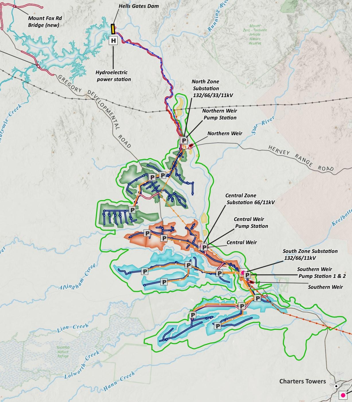
The project is located within the Charters Towers Regional Council (CTRC) Local Government Area (LGA), comprising the delivery of a 2,100 GL dam to support a 60,000 hectare agricultural irrigation scheme in the Upper Burdekin. The proposed Hells Gates Dam and Irrigation Scheme is located approximately 140 km north west of Townsville and 120 km north of Charters Towers. The proposed dam would be situated at the Hells Gates rapids on the Burdekin River and would serve as water storage for high value irrigated agriculture situated within an Agricultural Development Area (ADA) downstream of the dam, comprising three agricultural zones. Figure A highlights the project area (the dam site and ADA), within the defined study area. Supporting irrigation delivery infrastructure is to be located downstream within the ADA, including three additional weirs downstream of the dam wall and adjacent irrigation networks comprised of pumps, storage dams and pipelines that allows a fully pressurised system to deliver water to farm gates with high reliability and minimal system losses.
A dam at Hells Gates was first considered in 1938, a large scale water diversion scheme that was proposed to create new irrigation opportunities in inland Queensland and South Australia. Further investigations into developing the scheme occurred in 1973, 1975 and 1999. These investigations found that there was potential to support a dam in the area but noted that it required further investigation to refine the preferred options and verify the technical feasibility of dam development. In 2014, Townsville Enterprise Limited (TEL) commissioned the North and Northwest Queensland Sustainable Resource Feasibility Study (2014), which assessed opportunities for power generation and irrigated agriculture in the North Queensland region. The study found there were extensive opportunities for large scale irrigated agriculture in the Upper Burdekin catchment, but also noted that additional water storage was required.
In 2017, TEL commissioned the Hells Gates Dam Feasibility Study (the feasibility study) (SMEC, 2018). This document outlines options for the project’s location, scale, and configuration. The feasibility study supported the findings of the 2014 feasibility study in relation to opportunities for irrigated agriculture in proximity to the Hells Gates Dam and adjacent to the Upper Burdekin River. The feasibility study identified Hells Gates as the preferred location for a dam capable of providing the required water supply the region would need for future water security. In November 2019, TEL engaged SMEC, with support from KPMG, to prepare a Detailed Business Case (DBC) for the project under the Business Case Development Framework (BCDF) (DSDILGP, 2021). TEL has also engaged SMEC to prepare an Environmental and Social Impact Assessment (ESIA) and Reference Engineering Designs for the project at this time. The project is located east of the Australian Singapore Military Training Initiative (ASMTI) project in Greenvale and to the south of the proposed Hells Gates Pumped Storage Hydro project, with significant synergies in the development of opportunities across multiple projects.
Road and bridge upgrade works will be required to support this project, including upgrade of a portion of New Moon Road to provide access to the dam wall from Hervey Range Road. In addition, new electrical substations will be required in each irrigation zone, as well as new transmission lines connecting to the existing Milchester substation in Charters Towers. In addition to the supporting infrastructures outlined above, the DBC also considered the inclusion of a Toe of Dam hydropower generator as part of the Hells Gates Dam and Irrigation Scheme. The Executive Summary provides a summary of the Hells Gates Dam and Irrigation Scheme DBC, which has been prepared in accordance with the BCDF (DSDILGP, 2021). This DBC report has been prepared by SMEC, working in conjunction with KPMG, on behalf of TEL.
As captured in the Investment Logic Map (ILM), the primary service need for this project shows that the lack of secure water allocation and supply in the Upper Burdekin fails to support high value irrigated agriculture, constrains the regional contribution to national agricultural production, and limits ongoing employment and business opportunities. Investing in water access in the Upper Burdekin is particularly attractive due to the:

• significant scalability of suitable land (60,000 hectares), with an irrigation scheme to support the ADA and soil types present that will be able to support high value irrigated crop production
• proximity to existing built infrastructure required for the transportation and export of products such as the Port of Townsville, Townsville Airport and road and rail connectivity
• proximity to existing electrical infrastructure, which allows connectivity to the national electricity markets for power supply and renewable energy
• ongoing and unmet growing global demand for high quality agri food products
• the creation of a secure, year round reliable water supply will provide for new agricultural enterprises, boost the region’s economy, deliver job opportunities and strengthen the nation’s food supply chain including export opportunities. These new enterprises will attract investment to the region and bolster supporting industries and services.
A range of crop types and mixes have been considered in the development of demand scenarios for the project. These crop types have been selected on the basis of soil suitability and validated through stakeholder consultation and include:
• annual horticulture rockmelon, watermelon, capsicum, pumpkin
• perennial horticulture avocado, oranges, lemon, table grapes
• broadacre crops cotton, mung beans, soybeans, chickpeas, sugar, rice, fodder (Rhodes grass)
Demand scenarios have been tested at 352,108 ML and 549,652 ML of water supply and these two scenarios are captured in the detailed analysis of a medium and large irrigation scheme, as reflected in the options discussed below. Importantly, the market assessment undertaken in the preparation of this DBC has demonstrated strong market demand for the crop types considered, with potential customers indicating a strong preference to move towards high value agricultural production such as perennial crops.
The current iteration of the project had its genesis in the White Paper on Developing Northern Australia (2015) which outlined the Australian Government’s vision for the future of Northern Australia. The project also aligns with key strategic policy documents such as the Australian Agriculture’s Plan for a $100 Billion Industry. Currently, national agricultural production is $71.2 billion, with a target of an additional $28.8 billion over the next eight years, meaning to reach the target, the rate of value growth needs to more than double the current production rates (1.9% to 4.7%).

An assessment of agricultural demand and water use drivers identified a range of market opportunities, both domestically and internationally, and agricultural producer interest. Coupled with the scale of suitable land, favourable environmental conditions, and robust supply chain infrastructure and access, there is well documented evidence that supports the statement that: 1
Hells Gates Dam Irrigation Scheme is a transformational agricultural opportunity, that will double the value of crop production regionally, resulting in the Burdekin basin becoming the largest regional contributor to Queensland non livestock agricultural output, and account for an additional 3% of the total national annual crop production.
The project is a large water security development involving the creation of up to 549,652 ML of new water allocations that are not contemplated or provided for within the Water Plan (Burdekin Basin) 2007 (‘the Water Plan’) which is current as of 18 September 2020.
The Water Plan provides for several water infrastructure proposals in the Burdekin Basin, including:
• 150,000 ML of unallocated strategic water reserves in the Bowen Broken sub catchment for industrial purposes that may support the proposed Urannah Dam plus
• 150,000 ML of unallocated strategic water reserves for the future raising of Burdekin Falls Dam by up to 2m. In addition, the Water Plan also provides for:
• 200,000 ML of general water reserves
• 35,000 ML of strategic reserves for state purposes
• 8,744 ML Sunwater reserve.
The protocol2 defines the specific sub catchments in the Burdekin Basin at which each of these reserves are held. The protocol implicitly supports the proposed Big Rocks Weir development by including 10,000 ML/annum strategic reserve and 10,000 ML/annum general reserve in the upper Burdekin River sub catchment. However, the protocol does not provide any additional unallocated water reserve to support the proposed Hells Gates Dam and Irrigation Scheme project or a dam of any scale in the Upper Burdekin sub catchment.
Hydrologic assessments have been undertaken that show that the project can support the creation of up to 550,000 ML of supplemented water allocations in the upper Burdekin River catchment. However, the project and its proposed water allocations are not contemplated by, or provided for within, the current Water Plan (Burdekin Basin) 2007
The DBC has identified a number of potential pathways for addressing this challenge that include various combinations of one or more of the following water allocation strategies:
• creating a new additional unallocated strategic water reserve for the project which would require changes to the existing water plan
• reassigning some (or all) of the existing unallocated water reserves to the project
• extending the existing Burdekin Haughton Water Supply Scheme to incorporate the proposed Hells Gates Dam and Irrigation Scheme project and enabling existing distribution loss water allocations and/or unused water allocations that are located within the Burdekin Haughton Water Supply Scheme to be acquired and reallocated to the upper Burdekin
• reducing the volume of new water allocations to be created by the project (e.g. from 549,652 ML/annum to 352,108 ML/annum).
Each of these strategies would have water planning implications including for environmental flows and for the performance of existing and new water entitlements and require changes to be made to the Water Plan, the water management protocol and/or operations manuals.
In addition to the water allocation pathway scenarios identified above, three additional sensitivity analysis scenarios were modelled. These scenarios were chosen to examine the relationship between the full supply volume (i.e. size of the dam) and the project’s hydrologic resilience to climate change (assuming all other variables including volumes of project water allocations are held constant), with the results presented within this DBC.
In general, the modelling undertaken as part of this DBC, indicates that there are several pathways available to secure the volume of water entitlements that would be required to support the project.
Several of the pathway scenarios would result in no increase in the overall volume of existing and future water entitlements provided for under the Water Plan. However, changes to the Water Plan and associated protocols would still be required for these scenarios to enable the reassignment of some of the unallocated water reserves as well as to adjust a number of environmental flow objectives in the basin.
Sourcing sufficient water entitlements is a key issue that has been explored in the DBC. The above strategies are additional to the development of a regional approach to managing the proposed and existing water infrastructure and water allocations along the length of the Burdekin River. This is critical in minimising environmental flow impacts and maximising water supply reliability for both new and existing water allocation holders. The strategy also warrants further assessment and optimisation in close liaison with DRDMW in the pre construction phase of the project. The information presented above is also covered in more detail in the Water Allocation Strategy for the Proposed Hells Gates Dam and Irrigation Scheme Project (Badu Advisory 2022), provided as Appendix G
The Hells Gates Feasibility Study (SMEC 2018) assessed options for a dam at Hells Gates and Mt Foxton, both in the Upper Burdekin. Hells Gates was the preferred option as part of the feasibility study from an environmental and engineering perspective.
The DBC (SMEC KPMG, 2022) built upon the previous studies and considered a range of scheme sizes or scenarios for the project. These scenarios included agricultural footprint sizes of 60,000 and 31,700, with an additional third scenario of 12,200 hectares modelled and presented in the latter part of this DBC, including a sensitivity analysis on the economic impacts on each of the scheme sizes. The scheme sizes considered modularity within the scheme that allows for the development of the overall scheme in a phased approach for the Northern, Central and Southern irrigation zones within the ADA.
The two scheme sizes, or scenarios, considered intersect with performance criteria for economic impacts and water allocations to identify a sliding scale approach towards the future water allocation requirements for the scheme. These two scenarios also provide and support varying water planning and management pathways available to secure the required volume of water entitlements to support the project.
Land Area planted (ha) 60,000 ha 31,700 ha Zones planted North, Central and South North and Central Water Demand (ML) 549,652 ML 352,108 ML
Northern Zone 19,500 ha 19,500 ha
Hectares planted per zone (ha)
Central Zone 12,200 ha 12,200 ha Southern Zone 28,300 ha 0
Total hectares (ha) per scenario 60,000 ha 31,700 ha
Broadacre crops
Crop
tree
The table above provides the two key scenarios presented under the Hells Gates Dam and Irrigation Scheme for the options considered for development, with the additional Scenario 3 for a small size Scheme of 12,200 hectares provided in Section 15.8.4
The main components of the project include the Hells Gates Dam, three Burdekin River weirs, irrigation infrastructure across the ADA, electrical infrastructures and transport infrastructure. The dam has a storage capacity of 2,100 GL at the Hells Gates rapids on the Upper Burdekin River system.
The three weirs (northern, central, and southern) are downstream of the dam and will provide on stream storage that will supply water to irrigators within the ADA. At full supply level (FSL), the inundation area for the dam equates to about 18,500 hectares
The ADA is south of the dam and utilises the Burdekin to transport water from the dam to the three weirs, followed by a series of pressurised irrigation networks to deliver water to the farm gates. The ADA includes a select area of up to
60,000 hectares suitable for high value irrigated agriculture using water supplied from the Hells Gates Dam and weir storages. Figure B provides a summary of the key assets and their characteristics that make up the Reference Project.
This DBC proposes to build a dam for all staging options to mitigate significant cost increases associated with the raising of the dam at significantly higher escalated costs in future. Constructing a dam at full wall height will add to the cost of the civil works in terms of materials and labour, however, it will allow for the early realisation of the many benefits associated with the full sized dam. Constructing the dam to full height initially will be far more cost effective than raising the dam wall height at a later stage.
Construction of the full 2,100 GL water storage for the Hells Gates Dam will offer the maximum level of water resilience. This high level of water resilience and reliability has some trade offs in terms of environmental flows for the Burdekin Haughton Water Supply Scheme system which are discussed in the hydrological modelling results detailed in Section 5 Options Considered.
From a hydrological perspective, full dam construction will:
• improve resilience in the face of climate change
• allow for regulation of any water that is not taken as part of the Burdekin Falls Dam system
• allow for management of flows throughout the entire Burdekin Haughton Water Supply Scheme system; and
• provide an extension to the Burdekin Haughton Water Supply Scheme system and improve the performance of existing mainstream water entitlements.
From an environmental perspective, full dam construction will allow for the establishment of a whole new irrigated area with reliable water supply. The scheme will attract modern, innovative style agricultural investments that use new beneficial methods to meet Reef 2050 initiatives. The scheme will offer benefits well beyond what modifications to existing farming practice that the Lower Burdekin can achieve
Additionally, full sized dam construction will also:
• begin to alleviate groundwater pressures in the Lower Burdekin, taking the pressure off from an environmental perspective without losing productivity
• provide greater longevity of the Burdekin scheme, preventing salinity from working its way up the catchment. Other additional benefits provided by full dam construction include water reliability for the operation of a full pumped hydro storage system proposed adjacent to the Hells Gates Dam and the scale needed for the viable operation of the toe of dam hydropower, an integral part of the primary headworks infrastructure. Dam construction could be timed with the commencement of the proposed 808MW pumped hydro storage providing large scale, long duration energy storage and contributing to Australia’s target to provide 50% renewable energy by 2030.
The opportunities of the proposed pumped hydropower project are outlined in the Hells Gates Pumped Storage Project (HGPSP) Feasibility Study. This study identifies the three overarching drivers of the project as:
• arbitrage financial benefit from Scheme operation
• system stability benefits to the NEM in an environment where significant oversupply of renewables is apparent in the North Queensland electricity network
• in the longer term, foreseeing the progressive reduction of coal fired power plants in the energy mix, as a large scale, high capacity mechanical “battery” utilising a large copper wound iron core to provide system inertia to an increasingly destabilised electricity network.
Additionally, the full sized dam would also allow for the operation of the toe of dam hydro scheme. This scheme is installed as part of the dam construction and becomes operational under given flow conditions. Once operational, the Toe of Dam Hydropower scheme has economic and environmental benefits, that will be impacted negatively should a lower dam wall height and dam capacity be considered, and subsequently rendering the Toe of Dam Hydropower scheme unviable.
Recreational opportunities including access to water sports, camping and lifestyle facilities can also be developed through the realisation of the full sized dam.
In addition to delivering one of the largest new agricultural irrigation schemes in Australia for over a generation, the project will contribute to Australia’s renewable energy target of 50% by the year 2030 and net zero by the year 2050. The Reference Project includes delivery of the Hells Gates Toe of Dam Hydropower Project (26 MW), with this opportunistic investment making beneficial use of the environmental and irrigation releases, located on the left bank of the main dam structure.

The power, average annual energy and capacity factor for this arrangement are:
• power, estimated at 26,418 kW
• energy, estimated at 77,460 MWh per annum
• capacity factor of approximately 35.2%
While a small scale hydropower generator, the investment will partly offset the power utilised for the operation of the project, in particular the pumping loads expected from the irrigation scheme. It is also noted that the feasibility study has led to the concurrent (and now independent) investigation into a proposed Hells Gates Pumped Storage Hydropower Project (808 MW).
The environmental assessment study was delivered by a multidisciplinary team of technical specialists and was informed by an extensive program of desktop research, field investigations, computer generated modelling, impact analysis, stakeholder consultation and peer review. The assessment identified potential risks and impacts which may have a material effect on the project, as well as potential benefits and opportunities. The assessment also considered the regulatory framework, and key environmental approvals that would be required for the project to proceed.
This summary is not exhaustive but seeks to highlight priority issues and would require further investigation as part of a future statutory Environmental Impact Statement. This summary also identifies potential environmental benefits and opportunities, including benefits for the Great Barrier Reef (note that a more detailed analysis of benefits for the Great Barrier Reef is provided under ‘Sustainability’).
The approvals strategy for the project will be further developed as the project progresses; however, based on currently available project information, the primary approvals pathway is expected to include:
• controlled action referral under the Commonwealth Environment Protection and Biodiversity Conservation Act 1999 (EPBC Act)
• request for coordinated project status for the full project to be assessed under a bilateral Environmental Impact Statement assessment process under the Queensland the State Development and Public Works Organisation Act 1971 (SDPWO Act)
A range of secondary approvals under legislation including the Planning Act 2016, Environmental Protection Act 1994, Nature Conservation Act 1992, Water Act 2000, Vegetation Management Act 1999, Fisheries Act 1994 and Regional Interests Planning Act 2014 would need to be sought following primary approval and a final investment decision. The project would consider options such as a Ministerial Infrastructure Designation under the Planning Act 2016, or prescribed project status under the SDPWO Act to facilitate these approvals.
Timeframes to obtain the necessary approvals are challenging to predict given the unprecedented scale of the project, and the dependency on influencing factors such as progression of detailed design, and government support for an amendment to the Water Plan. However, for current planning purposes it is assumed that up to four years may be required to obtain primary Environmental Impact Statement approvals, and that the various secondary approvals would be obtained in stages as project implementation is progressed.
The project is located entirely within the Charters Towers Regional Council Local Government Area. The project footprint is zoned as rural under the Charters Towers Planning Scheme, and the dominant land use is agricultural production
Implementing the project would see approximately 18,500 hectares of grazing land converted to a waterbody within the inundation area, and up to 60,000 hectares of grazing land converted to irrigated agriculture within the ADA. In addition to this, substantial areas of land would also be required for supporting infrastructure such as roads and pipelines. The project would also require supplementary commercial, residential and industrial development in the vicinity of the project to provide housing for workers and support the agricultural supply chain.
Notably, portions of the ADA fall within the Central Reach Strategic Environmental Area (SEA) identified by the North Queensland Regional Plan. A Regional Interests Development Approval under the Regional Planning Interests Act 2014 is likely to be required, and there is potential that development in affected areas (both land based and within the Burdekin River) may be restricted.
Land suitability surveys identified approximately 60,000 hectares of land within the ADA that was suitable for irrigation with minimal amelioration. Substantial additional land is present which could still be used for irrigation but would require higher management inputs and amelioration costs. To reduce the potential for erosion as well as sediment and nutrient runoff, preferred irrigation areas are situated on slopes <3%, with waterway buffers ranging from 25 m for low order streams to 100 m for major waterways (including the Burdekin River).
Best practice irrigation technical would be implemented for the project, all of which would be consistent with the requirements of the Reef 2050 policy framework, and ERA 13A Commercial Cropping and Horticulture in the Great Barrier Reef Catchment. This would include the use of water efficient irrigation technologies based on good industry practice, recycling of on farm water run off, and limiting the application of fertilisers and pesticides where possible. A discontinuous, mosaic style geographic distribution of irrigation precincts would also be implemented, rather than a concentrated, centralised development
As noted below (refer groundwater hydrology), soil and groundwater assessments indicated a low risk of irrigation induced secondary salinity.
Pollutant export modelling indicated that once the project is operational, overall sediment runoff from the ADA would decrease due to improved land management practices. This would in turn result in reduced export of fine sediment loads and sediment associated nutrients to coastal areas, including the Great Barrier Reef Marine Park.
While overall sediment loads are expected to decrease, downstream turbidity during the dry season is likely to increase due to ongoing suspension of fine sediments within the Hells Gates reservoir, which would be released to provide for necessary environmental flows.
Dissolved nutrient concentrations within the local reach of the Burdekin River may increase by up to 10%, however overall annual nutrient load would decrease due to water extraction for irrigation. As such, the project is unlikely to result in water quality related impacts to coastal receptors such as the Great Barrier Reef Marine Park or Bowling Green Bay.
Preliminary modelling indicates that inundating the Hells Gates reservoir may result in a permanent increase in groundwater levels of approximately 2 m along some 27 km of the Burdekin River, and an increase in groundwater baseflow to the Burdekin River of up to 52 ML/annum.
Irrigation within the ADA may result in increases to the groundwater table ranging from 0.5 m to 4 m this is unlikely to result in significant secondary salinity impacts over the long term.
Both aquatic and terrestrial groundwater dependent ecosystems are present in the project area, and these may be affected by changes in groundwater levels.
Some of the strategies that have been considered for sourcing water entitlements for the project involve the lining of the Haughton Main Channel and secondary channels which would significantly reduce groundwater accessions and arrest and reverse groundwater rises in the Burdekin River irrigation area around Clare.
Historical pastoral regimes have degraded the majority of the habitat present in the project area, with the highest impacts observed in the inundation area. Despite this disturbance, the area still holds significant ecological values. The project is likely to impact Matters of National Environmental Significance under the Environment Protection and Biodiversity Conservation Act 1999 (EPBC Act) including four threatened flora species, 19 threatened fauna species, and two migratory species.
The project is also likely to impact terrestrial Matters of State Environmental Significance (MSES) under the State Planning Policy and Environmental Offsets Regulation 2014, including:
• four threatened flora species under the Nature Conservation Act 1992 (NC Act)
• 20 threatened or special least concern fauna species under the NC Act
• 124.5 hectares of high ecological significance wetlands Environmental Protection Regulation 2008
• 270 hectares of vegetation management wetlands under the Vegetation Management Act 1999 (VM Act)
• 2,838 hectares of “of concern” regulated vegetation under the VM Act
• the environmental attributes of The Central Reach strategic environmental area (SEA) and Great Basalt Wall designated precinct under the Regional Planning Interests Regulation 2014
• waterways providing for fish passage under the Fisheries Act 1994.
Design of the project has been adapted to reduce potential impacts to both MNES and MSES, for example by reducing disturbance within the SEA, or providing fish passage devices for the dam and weirs, however a significant level of impact remains an unavoidable consequence of the project. As such, substantial environmental offsets both direct and financial would be required.
No protected aquatic species are expected to be directly impacted by the project. As the Burdekin River is classed as a major risk waterway for fish passage, the Reference Project includes provision for fish passage devices for the dam (a fish lift) and weirs (vertical slot fishway).
Although installation of the fish passage devices will lower offset liability, substantial offsets for impacts to MSES (fish passage) are likely to be required.
The project also presents numerous environmental benefits and opportunities. These include:
• reduced sediment influx, consistent with the Reef 2050 policy framework, to the Burdekin River due to improved land management practices within the ADA (including the use of ‘best practice’ methods and technologies for irrigated agriculture)
• expanding irrigated agriculture in the upper (rather than lower) reaches of the Burdekin Basin, providing additional system buffering capacity against pollutant export to the Great Barrier Reef
• establishing irrigated agriculture in a portion of the Burdekin Basin which is significantly less susceptible to groundwater level increases and consequent secondary salinity (rather than expanding irrigated agriculture in an area with established secondary salinity issues)
• opportunity for fish stocking in dam and weir reservoirs, including for recreational fishing, or for ecosystem recovery
• opportunity to deliver a carbon neutral project (further information provided below under ‘Sustainability’).
The project is situated on the traditional country of the Gugu Badhun and Gudjala Peoples. The cultural heritage investigations for the DBC included desktop analysis of registered sites, use of a predictive landscape model to identify priority target sites for investigation, field investigation (concentrated around the inundation area and dam site), and consultation with key representatives from Gugu Badhun and Gudjala Peoples including board members, elders, field officers, technical advisors and legal custodians.
The Indigenous cultural heritage investigations identified a rich cultural landscape which had been extensively utilised by Aboriginal people in past times. Using a predictive landscape model to prioritise survey effort, a total of 107 cultural heritage sites were located in the vicinity of the proposed inundation area. These included burials, post contact safe havens, rock art sites, stone arrangements, ochre sources, earth ovens, camps, artefacts, quarries, rock shelters, stone sources, landscape features, springs, waterholes, wetlands and food resources.
The investigations provided an opportunity to gain greater appreciation of the cultural heritage values of the local area as these had not been well documented previously.
Multiple high heritage value sites including burials, refugia, painted art caves, earth ovens, ochre sources and artefact concentrations are located within the inundation zone, and would be directly impacted by the project. This would constitute a major loss of heritage for the Gugu Badhun People and to a lesser (but still significant) extent, for the Gudjala People
Investigations undertaken to date for the DBC have prioritised the inundation area, however it is recognised that further work will be required over the wider inundation area and ADA in order to more fully understand the potential impacts of the project.
Engagement and consultation with Traditional Owners has been a critical component of the DBC process, including the development of a framework for cultural heritage engagement which was presented to the North Queensland Land Council on behalf of Gugu Badhun Aboriginal Corporation (representing the Gugu Badhun People) and the Ngrragoonda Aboriginal Corporation (representing the Gudjala People)
The Framework also provided a project introduction and set out the engagement strategy including a commitment to core values such as free, prior, informed consent (FPIC), good faith, relationship development, governance, cooperative negotiation, as well as outlining the activities expected to be undertaken.
The Gugu Badhun People and Gudjala People have openly expressed their concern about the project going ahead due to the loss of heritage expected for the area. This sentiment has been communicated during in person consultation, as well as in writing. Both groups have noted expectations regarding their input to future project stages, including:
• to participate in decision making in matters which affect collective rights, and to be treated equally without discrimination
• to be engaged in good faith discussions about potential impacts, along with potential social and economic development opportunities, without prejudice and in good faith
• to be consulted and engaged on an ongoing basis on key issues including upstream and downstream community impacts, water rights (i.e. commercial gain and control of resource), and skills and training opportunities
• to be engaged in further extensive study within the area to fully understand the impacts and inform their response and mitigations.
Despite the impact to Indigenous cultural heritage, there are opportunities for the proponent to work with Traditional Owner groups to achieve positive community outcomes. Such opportunities, which will be further assessed in consultation with the Gugu Badhun People and Gudjala People, may include the following:
Conducting a regional study of Indigenous cultural heritage in the Upper Burdekin region in association with the proponents of other major projects in the region. The purpose of such a study would be to deliver a coordinated, first of its kind assessment detailing historical connectivity of the region through stories of culture, social organisation, practices and movement, human impact, settlement, anthropology and geology.
Preserving significant Indigenous cultural heritage in the region, for example by purchasing the land on which the cultural heritage is located and establishing covenants to prevent future development. This includes documenting the discovery of findings from the project to ensure preservation of the rich cultural history of the area.
Providing land and water allocations within the ADA to promote Indigenous business opportunities (for example irrigated agriculture or eco tourism)
Education opportunities in fields such as natural resource management, environmental monitoring, or archaeological studies
Procurement policies to allow Indigenous businesses to access work associated with the pre construction, construction and operational phases of the project.
Provision for a Traditional Owner Advisory Board that can collaborate with the Proponent to the next phase of the project to ensure a respectful pathway can be established. The content of the board will be decided through appropriate consultations with the TO Groups.
Combining Hells Gates and ASMTI cultural heritage investigations to deliver a coordinated, first of kind, ground breaking Regional Study of the entire Upper Burdekin detailing historical connectivity of the region through stories of Culture, Social Organisation, Practices & Movement, Human Impact, Settlement, Archaeology and Geology.
Unique opportunity to partner with Department of Defence to deliver one of the largest and most significant studies in Australia. As both parties are already doing cultural studies in the same area, with the same groups and the same technical advisors, tailoring these efforts to deliver a parallel output of regional significance could be done relatively efficiently and economically.
Work with Traditional Owners and refine the existing Cultural Heritage Management Application provided to both the Gugu Badhun and Gudjala People developed through the delivery phase of the project. The application allows for the identification of information, artefacts and areas of cultural significance from field investigations to be documented into a cloud based platform, including training for the Traditional Owner groups.
Following completion of the DBC, the next steps for the project would include:
• Ongoing engagement with the Gugu Badhun and Gudjala Peoples regarding project impacts and potential opportunities for Indigenous communities
• More detailed cultural heritage survey of the project footprint
• Establishing Cultural Heritage Management Agreements and Indigenous Land Use Agreements with the Gugu Badhun and Gudjala Peoples
Future project activities would also be informed by lessons learnt from nearby Australia Singapore Military Training Initiative (ASMTI) project. Additionally, the project recognises that there are significant opportunities to draw upon existing relationships, processes and procedures developed through the delivery of the ASMTI project.
Townsville Enterprise Limited has committed the project to becoming carbon neutral. For an organisation or project to be considered carbon neutral its net carbon emissions must equal zero. To become carbon neutral, companies must rigorously calculate their carbon footprint, reduce it as much as possible, then purchase and retire carbon offsets to the equivalent of the remaining emissions. As it currently stands, the price of Australian carbon credits is $30/t and so using the preliminary carbon footprint data, annual costs to purchase carbon offsets would be $1.4 million during construction and $8.3 million during operation. The sustainability assessment for the Hells Gates Dam and Irrigation Scheme considers more than just the direct impacts, benefits and opportunities associated with the planning, construction, and operation of the project. The scale and potential for this project will be realised at local, regional, and state levels. This assessment has taken the more technical assessments provided by the specific Environmental and Social Impact Assessment and Business Case chapters and distilled the key information to provide a holistic perspective.
The proposed location for the project predominantly comprises grazing land, which is prone to extensive gully erosion, leading to sediments travelling downstream and potentially impacting the water quality, ecology and fisheries of the Burdekin River, Charters Towers Weir, Burdekin Falls Dam, and the Great Barrier Reef. Furthermore, the population of Charters Towers (approximately 11,731) is currently declining at an average annual rate of ‐0.48% since 2010.
Projecting into the future, the impacts from climate change are likely to further degenerate the region as water scarcity increases This is a result of drought, more intense rainfall and storms exasperating the already severe erosion and physical damage to seagrasses, corals, wetlands and other aquatic ecosystems, increased temperatures causing coral bleaching, and rising sea levels increasing the extent of marginal cropping land in the Lower Burdekin.
As the impacts of climate change worsen, the viability of cattle farming and benefits from the Great Barrier Reef and downstream environment (e.g., tourism and fisheries) may be at risk. The flow on impacts of degenerating conditions in the region will exacerbate population decline, local economy and local job opportunities.
This project will create an opportunity to transform the regions’ economic, social and environmental future. The initial consideration of how a dam and irrigation scheme can create positive environmental outcomes seems counterintuitive, but the project enables opportunities for regeneration and reversal of the current degenerative situation.
The assessments undertaken as part of this DBC have provided the direct impacts and benefits of the project, but there are other significant opportunities that can be realised. This is especially true as the project aspires to be the most sustainable dam and irrigation scheme in Australia, and potentially the world. The key environmental opportunities that can be realised by the project, include:
• water security and water cycle management
• ecological opportunities
• carbon, energy use and renewable energy
This project considers and responds to the impacts of climate change and will include appropriate treatments and adaptations for the infrastructure assets, but the project will also improve the resilience of the region from a changing climate. There will be added opportunities associated with the broader development of towns and industries that can be realised by including climate change considerations in local planning and development requirements. This will ensure that more resilient communities are established. Increasing storage capacity throughout the Burdekin River (i.e. Hells Gates Dam and downstream weirs) will enable larger volumes of inflows from potentially less frequent but more intense rainfall events to be stored for subsequent supply to water users, thereby improving the resilience of the region from a changing climate.
As a part of the DBC and Environmental and Social Impact Assessment for the project, a preliminary carbon footprint assessment has been conducted for the greenhouse gas (GHG) emissions that could be generated during construction and operations. Furthermore, Townsville Enterprise Limited has committed the project to becoming carbon neutral,
with a carbon neutral strategy to be developed for the project during the pre construction phase, and to be adopted before detailed design and construction works commence.
Based on the assessments undertaken as part of the DBC and Environmental and Social Impact Assessment and due to the scale of the project, it is recommended that a Sustainability Strategy be developed with guiding objectives and targets. Such a strategy would align with key government policies and strategies to help guide all phases of development, providing high level vision and direction for not just the project, but for the region. This could also encompass the use of measurement tools to evaluate the performance and track progress towards targeted sustainability outcomes.
The origin of the project and associated regional economic potential aligns with and contributes to aims of:
• North Queensland Development plans
• Queensland Climate Transition Strategy
• Queensland Climate Adaption Strategy
• National Action Plan for Salinity and Water Quality Assessment
• Reef 2050 Long Term Sustainability Plan
The Hells Gates Dam and Irrigation Scheme will play a key role in Australia’s agriculture industry, adopting carbon strategies to meet Australian and Global carbon targets. The emerging carbon market is providing a new revenue stream and broadening on farm diversity and practice. The scheme provides opportunity to become involved in government funded carbon farming programs offering improvements to soil health leading to increased productivity and profitability of farming operations.
As a part of the DBC and Environmental and Social Impact Assessment for the project, SMEC has conducted a preliminary carbon footprint assessment of the greenhouse gas (GHG) emissions that could be generated during construction and operations.
After a preliminary investigation of the specifics of the project and its consumption of resources, preliminary annual GHG emissions were calculated to be:
• pre construction not considered in this assessment
• construction 52,000 t CO2 e (assumed to occur from 2028 2032)
• operation 277,00 t CO2 e (assumed for 2033 onwards).
The breakdown of the carbon footprints for construction and operation of the project are each shown below. In the construction phase, Scope 3 emissions make up 75% of total emissions and relate to the indirect carbon emissions resulting from production and transport of materials required to build the infrastructure and the transport of staff to reach the construction sites. Scope 2 emissions (electricity use) relates to the construction/accommodation sites and was estimated to account for 15% of total carbon emissions and Scope 1 emissions (fuel used in construction site machinery) was estimated to account for 11% of total emissions.
During operations, 75% of the carbon footprint was made up of Scope 2 emissions which is the net electricity consumed by the project infrastructure (total energy consumed minus the amount generated by the hydroelectric power station). The remaining 25% is related to Scope 3 emissions including the transport of crops to Townsville and possible carbon emissions released by the dam inundation area.
A carbon neutral strategy for the project, which will be implemented once final project design is approved and ready for construction, includes:
• preparation of a detailed carbon footprint of the final approved design


• the purchase of carbon offsets, only: after all emission reductions have been examined those validated by the Clean Energy Regulator focus on purchasing Australian carbon offsets.
The Commonwealth and Queensland Governments’ Reef 2050 Long Term Sustainability Plan (Reef 2050 Plan) highlights the threats to the Great Barrier Reef from land based sources of water pollution, including agricultural sources. The Hells Gates Dam and Irrigation Scheme provides the opportunity to establish best practice innovative technology in the irrigation scheme, land and water management in the Burdekin Basin, which would reduce sediment and nutrient loads flowing to the coastal ecosystems and the Great Barrier Reef. As noted above under ‘Environmental’ positive outcomes for the Great Barrier Reef would include:
• The Hells Gates Dam and Irrigation Scheme would reduce sediment and nutrient loads delivered to the downstream Burdekin Falls Dam due to significantly improved land management and agricultural practices within the project area (e.g. buffer strips along waterways, recycle pits, controlled nutrient application, capturing runoff for re use, compliance with the Reef Regulations), and water take by the scheme Current land practice is dominated by grazing and there is extensive gully erosion, which is delivering large volumes of sediment and associated particulate nutrients into the Burdekin River.
• Expanding irrigated agriculture in the upper (rather than lower) parts of the Burdekin Basin, will provide additional system buffering capacity against pollutant export to the Great Barrier Reef. The large water volume of Lake Dalrymple provides a buffering affect as the holding time in the lake allows for sediments (and associated particulate nutrients) to settle out of suspension before being released to the lower Burdekin River and the Great Barrier Reef. There is limited buffering of pollutant runoff from sugar cane areas of the Lower Burdekin, which flow into coastal ecosystems and the Great Barrier Reef Marine Park via surface and groundwater. In the Lower Burdekin area, high rates of fertiliser application and large losses of irrigation water to waterways, wetlands and coastal ecosystems can significantly impact ecosystem health and function such as nutrient enrichment, water oxygen depletion and fish kills. Rising water tables are also evident in the Lower Burdekin irrigation areas, which can lead to waterlogging, increased salinity in the root zone and altered productivity.
Australia has a confirmed target of being 50% renewable by the year 2030 and net zero by the year 2050, although variations of these targets have been set and discussed across states and territories that has and will influence the national targets around energy and net zero. Fundamentally, the targets will require major investment and tangible assets that seeks to either reduce the greenhouse gas emissions or offset emissions.
Hells Gates Toe of Dam Hydropower Project (26 MW)
Hells Gates Toe of Dam Hydropower Project (26 MW) is an opportunistic investment that has been developed at the toe of the Hells Gates Dam making beneficial use of the environmental and irrigation releases, located on the left bank of the main dam structure.
The power, average annual energy and capacity factor for this arrangement are:
• power, estimated at 26,418 kW
• energy, estimated at 77,460 MWh per annum
• capacity factor of approximately 35.2%
While a small scale hydropower generator, the investment will partly offset the power utilised for the operation of the overall scheme, in particular the pumping loads expected from the irrigation scheme.
Proposed Hells Gates Pumped Storage Hydropower Project (808 MW)
Hells Gates Pumped Storage Hydropower Project (808 MW) SMEC2021 is a completely independent scheme to this project (the DBC) and has been developed as an opportunity for a large scale renewable generation project.
The three overarching drivers of the Hells Gates Pumped Storage Hydropower project have been developed as:
• arbitrage financial benefit from scheme operation
• system stability benefits to the National Electricity Market in an environment where significant oversupply of renewables is apparent in the North Queensland electricity network
• in the longer term, foreseeing the progressive reduction of coal fired power plants in the energy mix, as a large scale, high capacity mechanical “battery” utilising a large copper wound iron core to provide system inertia to an increasingly destabilised electricity network.
There are a number of synergistic opportunities between the Hells Gates Dam and Irrigation Scheme with other projects in the area in particular the opportunities around partnerships with the ASMTI projects both during the development and operational phases of the project, including sharing knowledge and lessons learnt regarding infrastructure development in the area.
The estimated
Table
in Table
bn. This includes

Demand for Australian agricultural assets are increasing. The median price per hectare of Australian farmland increased 12.9% in 2020 to $5,907 per hectare (Rural Bank, 2021). This marks the seventh consecutive year of growth, bringing the 20 year compound annual growth rate (CAGR) to 7.6% (Rural Bank, 2021).
Given the large scale of the irrigation development, it is evident that the capital required to develop the Hells Gates Dam and Irrigation Scheme will not come solely from existing landholders. Rather, it will most likely come through investment partnerships between existing or new landholders, banks and equity funds. In particular, those funds whose investment mandates are directed towards agriculture. Several corporate agriculture companies were also consulted to understand their level of interest in the project.
To assess the demand for water from capital markets, a market sounding of 20 of the major providers of capital to agriculture in Australia was conducted between July and October 2021. Observations from the consultation activities include:
• there was a high degree of alignment between the characteristics sought by the investors consulted and the characteristics of the project This includes region, soil type and production opportunities, water reliability, price and pressurised delivery, proximity to markets, transportation, logistics and access to labour.
• of the twenty investment funds consulted, there was a broad consensus that the project would be an attractive investment proposition based on the Reference Project assumptions outlined. Key attributes of interest were:
the Reference Project’s large scale water properties (reliability, price, and pressurised delivery) the potential for value uplift based on the conversion of greenfield land to intensive agriculture
• the scheme’s proximity to markets, transportation and labour made it comparatively attractive. Many of the larger institutional investors stated they had difficulty finding investment opportunities of sufficient scale to satisfy the requirements of their investment mandates and minimum investment size.
• 95% of surveyed respondents stated that they continue to look for large scale, long term water investment opportunities to build on their existing portfolio.
• of the corporate agriculture companies consulted, many reported they have been looking for competitively priced water to expand production of high value horticulture. Highly reliable water was preferred given the likely expansion of their production of perennials. In line with this, most corporate agriculture companies stated they are targeting heavier, clay soils similar to those in the ADA.
• it is likely that capital markets will continue to look for reliable, large scale, long term water assets, with properties similar to the Hells Gates Dam and Irrigation Scheme to invest in. Desktop research and consultations support the DBC’s position that capital is not likely to be a limiting factor in the construction or operations phases of the project.
There are opportunities for the Reference Project to deliver meaningful cultural and economic outcomes for Indigenous people within the Charters Towers and for Australian Indigenous people more broadly. Consultation with the Indigenous Land and Sea Council confirmed that the project aligned with their investment mandate and that they are interested in pursuing the opportunity further.
To assess willingness to participate in the scheme from local farmers, all available landholders within the ADA were consulted either by a face to face interview where possible (given COVID restrictions) or telephone interview. A recent expression of interest process confirmed that the market is prepared to accept the estimated water price.
In the process of developing this DBC, one on one consultations were held with the 15 major landholders within the proposed ADA and inundation area. A public Town Hall was also held in Charters Towers with Townsville Enterprise Limited in March 2021 to brief the local community and to communicate key details and timelines of the project.
Consultation found some landholders:
• stated they were interested in developing part of their land for irrigation
• stated that given the long lead time of the project, it is something that would be considered closer to the time of the project coming to fruition
• stated that access to highly reliable water would unlock production opportunities for their families
• raised questions over the impact of the irrigation scheme on existing water rights
• noted investment is already underway in some areas to develop land to grow non traditional crops such as cotton and safflower, including for ethanol production.
From the research undertaken regarding market demand for water from the project, it is noted that:
• the land and water development elements of the project require approximately $1.7 bn in funding and this necessitates partnerships between landholders and non farm capital
• landholders expressed different views about investing in water and irrigation development. Some are ready to invest and partner, others want to assess the detail and others are currently not likely to invest. The long lead time means current landholders will re assess their positions based on changing generational positions
• the large agricultural focused funds are generally very supportive of the project. If the project proceeded along similar lines to the assumptions outlined in this business case it is very likely that the project would attract the necessary capital to purchase water entitlements and development the ADA. Letters of support from potential investors are provided in this DBC.
These entities are, collectively, assumed to generate the demand for the land and water entitlement offerings that would be put to the market once there is greater certainty that the project will be progressed.
The model proposed, is based on seeking binding contractual commitments from these entities to purchase the land and water assumed, at this stage, to mirror other southern irrigation developments, with financial contributions in tranches of 2%, 8% and 90% as described elsewhere in this DBC.
To undertake a preliminary market assessment of the appetite for these investments, direct market demand research was undertaken with existing landholders and twenty of Australia’s largest agriculture investment firms, noting there is an element of work required as part of the pre construction phase of the project through the series of gates presented to critically de risk the project development ahead of non binding and binding commitments.
Key features of the project that were identified as favourable by entities surveyed included the following:
• the greenfield nature of the scheme with abundant water and land available for development
• favourable cropping conditions and proximity to transport and other required infrastructure
• the contemporary scheme design, including the mechanisms to deliver the water from bulk source to farm
• competitive water prices for a scheme of this size (compared to other irrigation schemes nationally), both the upfront cost of purchasing water entitlements and ongoing water charges once scheme operations commenced.
These demand surveys and follow up consultations, which include recent Expressions of Interest (responses are attached in Appendix F) built on detailed market research and on farm profitability studies undertaken for the project.
Of the investors consulted, 100% stated that the proposed water price (annual and ongoing) is both competitive and acceptable to the market.
The conclusion was that there is sufficient potential demand for land and water offerings from the large scheme (circa 60,000 hectares and 549,652 ML/annum) to assume in the financial modelling that:
• approximately 25% of the capital costs for the reference project would be able to be funded by irrigators and investors; and
• the ongoing water charges were competitive, relative to other projects and investment offerings.
The delivery of the Reference Project is anticipated to generate significant producer benefits in the form of an uplift to agricultural output. The uplift in agricultural output has been estimated by allocating the additional water made available for irrigation purposes to the different productive soil types within the project area.
A staggered planting ramp up and relative timeframes to maturity with the first year of operations commencing in 2034, full production of the scheme is not anticipated until 2048.
Over
This
Construction
years
Table C, it is estimated that the
$4,805.46 million (PV, 7%).
all three
Project will result in
which account for 82% of
the ability of the scheme
$2,188.61
$689.86 $340.76
farm $458.32 $251.15
$206.61
$2,987.13
$26.27
SCENARIO 1
Economic NPV @ 10% $1,185.16 $851 90
Table D presents a summary of the economic analysis for three (3) scenarios considered within the development of the project. Sensitivity of the results to movement in the discount rates is also captured below.
Table D Economics Results for the Reference Project, under different evaluation periods
DISCOUNT
Net Present Value (NPV) $m $5,419.69 $236.10 $1,185.16
Benefit Cost Ratio (BCR) 1.83 1.05 0.65
Internal rate of return (IRR) % 7.30%
Net Present Value per dollar of investment (NPV/I) $0.83 $0.05 $0.35
Net Present Value (NPV) $m $2,301.86 $499.62 $1,374.20
Benefit Cost Ratio (BCR) 1.38 0.89 0.59
The above analysis confirms that the project, under the Reference Project ADA scenario (i.e. of 60,000 hectares), is anticipated to generate an economic return to society, with observed benefits outperforming the related costs over the appraisal period. An ADA with 31,700 hectares would deliver a break even socio economic return, where a dollar or economic benefits would be realised for every dollar invested, while a small scheme solution would fail to deliver a positive socio economic return.
The Reference Project would deliver approximately $4.8 bn in economic benefits (PV, 7%) and return $1.05 dollar for every dollar invested, at a real discount rate of 7%. This economic return increases to $1.83 dollars under a real discount rate of 4%.
In addition to the direct economic impacts that are captured in the CBA, the project will have indirect (or flow on) impacts on the economy. These indirect impacts emanate from a range of sources including:
• supply chain linkages, where other businesses in the economy provide goods and services to the businesses that are directly impacted by the project activities (businesses contracted to develop and construct the project and farm businesses that gain access to water for irrigation purposes)
• supply constraints and other constraints that result in competition for resources induced by the increase in construction and farming activity generated by the project
• income effects flowing from the stimulus to jobs, wages and profits that the project instigates.
To quantify these flow on effects, macro economic modelling was undertaken, with Table E presenting the anticipated
economy impact resulting from delivery of the Reference Project.
•
During the operational phase, when full production has been reached, a total of nearly 3,451 additional ongoing FTE jobs is expected to be generated in the Townsville region. This is equivalent to almost 172,550 job years of additional FTE employment over the 50 year horizon. At the national level the impact of the project on aggregate employment is assumed to be zero. This follows from the long run assumptions that the national supply of labour and the equilibrium rate of unemployment are unaffected by the project.
In nominal terms, the total capital costs of the project are expected to be $7.257 bn ($5.4 bn in real terms) (including a contractor risk and opportunity allowance, and Proponent costs and risk and contingency).6
These capital costs will be partially offset by an ‘irrigator contribution’ amount (called the water access entitlement charge) of approximately 25% of the capital cost of the majority of the works (e.g., all capital costs excluding the early works packages).
In the operations phase of the project, the revenue earned through the annual water price exactly offsets the operations, maintenance and lifecycle costs of the project, other than:
• the cash flows related to the Toe of Dam hydropower station; and
• some minor costs associated with the dam wall which are incurred prior to the commissioning of the irrigation network (e.g., the point in which revenue earning commences).
As a result, the project in its own right is not able to generate a commercial return and there is a large funding gap. As captured in Table F, the total estimated revenue from water entitlement charges, based on an estimated average price of $2,313 per ML, is estimated at $1.7 bn. Accounting for some further revenue offsets from the Toe of Dam hydropower station, at approximately $0.1 bn, the estimated funding gap for this initiative is approximately $5.4 bn.
For investor consultation purposes, $2,000/ML $2,400/ML was presented as the lower and upper bound water price for high priority water. This water price is consistent with the average water access entitlement charge assumed in the cost recovery model. However, based on the modelling completed, as there will be two types of water product supplied by the project’s irrigation scheme, the actual upfront price for high priority water allocations is likely to be more than $2,000 per ML and the upfront price for medium priority water allocations is likely to be less than $2,000 per ML with a resulting overall average of the two as assumed in the analysis. These prices will likely to be informed by the development and application of headworks utilisation factors as documented by the Queensland Competition
4 For the construction phase, jobs refers to the number FTE person years of work generated 1 person working full time for 1 year is counted as a job.
5 For the operational phase, jobs refers to the number of permanent, ongoing FTE jobs created.
6 A p90 risk contingency has been adopted for capital costs comprising a risk profile in both planned and unplanned risk categories. Refer to section 7.4 for further explanation of probabilistic costs.
Authority and applied by bulk water providers throughout Queensland when making water pricing determinations. If it is ultimately determined to have more than one water product as detailed above the total cost of water would not change but rather the model would rebalance water pricing across the water products with unchanged total costs/revenues back to the scheme.
Table
Capital
Revenue:
Remaining
Revenues and costs associated with the operations, maintenance and lifecycle replacement of the dam wall and irrigation network
Minor costs associated with the dam wall which are incurred prior to the commissioning of the irrigation network
Toe of Dam hydropower station
The affordability assessment undertaken as part of this DBC has identified a number of approaches that could be used to meet the funding gap (in part or in full). This includes:
• Queensland and/or Australian Government investment
• increasing the irrigator contribution (‘water access entitlement charge’) higher than the current contribution of approximately 25% (noting this is subject to ‘willingness to pay’ of irrigators)
• setting the annual water price at a value selected by government which is higher than pure cost recovery (noting this is subject to ‘willingness to pay’ of irrigators). This is the subject of a scenario analysis which has run sensitivities based on the variables outlined in Section 9.5
• including a return of capital charge in the annual water price (noting this is subject to ‘willingness to pay’ of irrigators)
• performing additional due diligence on the Toe of Dam hydropower station to determine whether the investment is financially viable in its own right and represents value for money
• investment in a separate (but related) asset the HGPSP
• other investment programs in the region
• well structured interaction with the private sector (for example, through an availability based PPP model, running a contestable process with the private sector to finance and fund part of the infrastructure network and/or loans from the private sector).
The capital cost assumed amount to $7,257 million in nominal terms. The market demand assessments indicate a potential source of funding of $1,713 million from irrigators from the sale of water allocations. In March 2022 the Australian Government announced a funding commitment of the remaining $5,442 million, subject to a number of conditions.
The cost estimates and funding estimates will be further refined in the pre construction phase of the project. This includes:
• water allocation sourcing strategies this addresses any capital cost implications of sourcing water entitlements for the project
• refinement of other capital cost estimates based on updates to capital and, to a lesser extent, operating cost estimates based on further project studies and reviews
• update on market demand further irrigator/investor capacity to pay studies, including whether the $1,713 million upfront capital funding assumption requires refinement based on updated project costs
• consultation and negotiation on the funding model the funding model assumed at this stage includes the Queensland Government providing water allocations to individual Hells Gates Dam and Irrigation Scheme
customers in return for upfront payments. This is a preliminary model only, that seeks to highlight the size and timing of the possible funding arrangements required. Further consultation with the Queensland Government is proposed on this matter in the next stage of works.
The upfront water entitlement paid by irrigators to access water has been calculated based on the total risk adjusted costs of the project, as shown in Table G. Notably, the early works component of the capital cost is not included in the irrigator contribution. For all other packages of work, it is assumed that irrigators contribute approximately 25% of the capital cost. This is then divided by the water allocation to return the upfront water entitlement price of $2,313 per ML in real terms as tested by the current expression of interest process conducted (or $3,118 per ML in nominal terms).
Supporting this is the nominal (i.e., escalated) capital costs which align with the Federal Government commitment to the project. Of note, there is a gap between the total cost and that paid by government and irrigators associated with the Toe of Dam hydropower station which covers the $107 million gap.
Table G Water Price
A Early works $294m
B Dam wall $1,556m
C Irrigation networks $3,331m
D Electrical infrastructure $198m
Total Cost (Real) $5,379m
$294m $0
$1,167m $389m
$2,498m $833m
$149m $50m
$4,108m $1,271m
Cost per ML (real) $2,313 / ML
Total Cost (Nominal) $7,257m $5,442m $1,713m
Cost per ML (nominal) $3,118 / ML
The project funding is assumed to comprise $5.4 bn from the Australian Government and $1.7 bn from irrigators and investors from their purchasing of water access entitlements. As outlined above, it is assumed that approximately 75% of the capital funding will be sourced from the government and approximately 25% from the irrigators/investors.
However, there is also an important financing issue that will need further assessment on the next stage of the project’s development. This includes assessing avenues to minimise any temporary finance timing mismatch, for instance, if the full capital costs of the project are to be paid for before the majority of the funding is received from the irrigators and/or the government.
Options that could be explored include negotiations with the Australian Government to optimally align payments with the construction cost outlays; and variations to the assumed irrigator/investor payments, either the amount assumed to be paid in total, and/or the proportion of these payments at each stage (i.e. varying the 2%, 8% and 90% tranches as outlined in detail in the later chapters). However, it is noted that changing these funding parameters for irrigators/investors may impact their willingness to pay for water entitlements.
There may also be opportunities to explore some of the funding being provided through private sector financing avenues, although this may have implications on total project costs.
The potential substantive future role of the Queensland Government in this project has important implications here, noting the DBC conclusion of the need for consultations in the next stage on the preferred proponent for the project, particularly for the bulk infrastructure (i.e., dam and weirs). It will therefore also be essential for early engagement on these and other financing options with the Queensland Government, and possibly Sunwater, in the next stage.
The project has been uniquely developed as a staged infrastructure development scheme, that takes into account a pre construction phase, a pathway for obtaining the necessary water allocations, natural construction phase sequencing, the economic return on investment and ability to refine the operability at different levels of scheme maturity.
Staging of the overall scheme is inherently built into the sequencing of the Hells Gates Dam and the corresponding irrigation scheme, developed as three distinct agricultural zones, including central, northern and southern irrigations zones respectively.
More specifically, the Hells Gates Dam and Irrigation Scheme is proposed to be developed based on the following phases:
• pre construction phase
• Phase 1, central irrigation zone
• Phase 2, northern irrigation zone
• Phase 3, southern irrigation zone.
This phased approach ensures that the critical primary infrastructure is in place to allow for full agricultural development to take place for each zone. The works under each phase are further discussed below.
Pre construction phase (2022 2027)
The next phase of activities fundamentally develops the scheme to a level that supports the project to transition into construction, staging, investment, and commercialisation. It also provides an opportunity to de risking the overall project and will enable further exploration and capture of socio economic and financial benefits.
Primary activities for the next stage of works include expanded and detailed stakeholder engagement, investment pathway planning, and a detailed Environmental Impact Statement (EIS), and associated engineering design. Additional activities are captured in Table H below.
The delivery of the next phase of the project, known as the pre construction phase, requires funding of $280 million awarded for works over a 5 year period between 2022 and 2027 in preparation for all activities to de risk the project prior to delivery phase. The gates provided below are indicative only and are subject to change depending on the approval timelines following the commencement of the pre construction phase. These timelines would need to be discussed with all parties prior to execution of the grant deed. Table H is a living document that will be refined to align with an inherent sequence of works based on sufficient certainty around market demand, water allocation, infrastructure size (in particular dam size) and confirmation of project proponent. It is therefore proposed the delivery of the pre construction phase be undertaken through a series of gates that align with critical decision making process for the proponent and the government. These gates are presented below.
A further example of how the following table is indicative and may need to evolve over time relates to whether the distribution scheme is split from the bulk scheme. That is, if the bulk scheme proponent (for the dam and weirs); e.g a State Government entity) is separate to the distribution proponent (for the irrigation scheme, e.g. for a local management arrangement), this will impact the tasks in Table H, where there would need to be separate tasks and decision stages for both.
In
In
Advance
Commencement
Either:
1.Delay whilst
2.Project unable to advance
Delay whilst
Delay while
Delay
Confirmation
Options
Declaration
Environmental
Either:
1.Delay while undertaking
2.Project unable to advance
Delay in securing
Construction unable to
Delay with finalisation
Either:
1.Delay while
and/or
2.Increase in cost, which
aspects of
Either:
1.Delay
2.Construction
Subsequent delivery phases (2027 2033)
The delivery of the construction phase of the project can commence once all approvals have been received by the project. The approach to the delivery of the overall scheme is based on a sequence of critical and necessary infrastructures packages to allow the construction of sufficient infrastructures for commercialisation of the scheme and presented below:
Early works, and the construction of the central irrigation zone and dam infrastructure, resulting in:
• Total Agricultural Footprint: 12,200 Ha
• Cumulative Water Allocation: 134, 656 ML
• Package A Early Works Package (including 3 separable components)
• Package B Main dam works and associated infrastructure (2,100 GL Dam)
• Package C Central irrigation infrastructure, stage 1a (initial 12,200 Ha).
• Package D Electrical Infrastructure and services, stage 1a. This includes the provision of the primary high voltage transmission line from the NEM to the central zone
Irrigation and supporting electrical services, resulting in:
• Total Agricultural Footprint: 31,700 Ha
• Cumulative Water Allocation: 352,108 ML (transfer of additional allocation from other projects)
Irrigation and supporting electrical services, resulting in:
• Total Agricultural Footprint: 60,000 Ha
• Cumulative Water Allocation: 549,652 ML
Activation of the northern zone, through following two construction packages:
• Package C Irrigation infrastructure, stage 1b (an additional 19,500 Ha)
• Package D Electrical Infrastructure and services
Activation of the southern zone, through following two construction packages:
• Package C Irrigation infrastructure, stage 1c (an additional 28,300 Ha)
• Package D Electrical Infrastructure and services, stage 1c Southern
The Hells Gates Dam and Irrigation Scheme is a multi infrastructure project that includes the development of a major agricultural opportunity, inclusive of one of the largest dams in Queensland, one of the largest pressurised irrigation systems and potential for future water security for urban development in the long term future as the project develops through its operation lifecycle and opportunities for the project to support the 2030 national renewable targets and net zero strategy through the provision of renewable energy projects.
This project is a significant national building project with a Benefit Cost Ratio of 1.05, at a real discount rate of 7% for a 50 year reference period. The Reference Project will result in an additional $0.8 billion in gross regional crop production annually from 2034 in real terms and will contribute $1.3 billion to GRP from construction and a further $6.0 billion to GRP from operations (in present value terms). The Reference Project will be able to support 10,6007 construction jobs and further 3,300 operational jobs8
The project will add an additional 3% to the current horticultural portfolio for the State of Queensland and aims to have a major net positive impact to the national agricultural targets set by the Federal Government’s initiatives to not only double the agricultural production in Northern Australia, but to become a $100 billion agricultural economy by 2030.
The project is uniquely placed within the Charters Towers Local Government Area and in proximity to pre existing major infrastructure including for power supply, transport, airport and port significantly improving the ability of the scheme to leverage off these assets and services. This also provides the project modularity and scalability, with the three (3) irrigation zones (northern, central and southern) delivered in a phased approach.
The pre construction phase (2022 2027) will critically de risk the final development and investment framework for the project with detailed engineering designs, environmental and social impacts, economic and financial analysis, irrigator commitments and development of the project ownership model. The project is unique in its location and intersects with areas of cultural and environmental significance that requires a structured approach to the delivery of the project
The construction phase (2027 2033) will deliver the key assets that collectively make up the project. The dam, irrigation and associated supporting infrastructure will be delivery based on the investment pathway and ownership model developed as part of the pre construction phase, which will build on the delivery and financing models considered and put forward in this DBC.
This DBC presents pathways for the development of the overall scheme, and funding gaps, as well as opportunities for investment, the sequence of activities and procurement strategies for the project in its entirety.
The economic and social analyses have highlighted considerable benefits for the Charters Towers and Townsville regions, both during construction and upon commencement of scheme operations. It is also important to highlight the potential benefits for the neighbouring Burdekin region, to the east and south east of these areas, respectively.
The Burdekin region has long been a leading Queensland agricultural hub, initially based on groundwater irrigated cropping and later a weir based irrigation scheme. Over the past three decades this has increased considerably through additional irrigated broadacre (mostly sugarcane) and horticultural production reliant on water supplied by the Burdekin Falls Dam, through the Burdekin Haughton Water Supply Scheme.
The region is, therefore, already relatively well serviced through both reliable irrigation water supplies and a developed agricultural services sector.
7 For the construction phase, jobs refers to the number FTE person years of work generated 1 person working full time for 1 year is counted as a job.
8 For the operational phase, jobs refers to the number of permanent, ongoing FTE jobs created.
However, the Hells Gates Dam and Irrigation Scheme offers considerable opportunities to further expand the productivity and wealth of the Burdekin region through two avenues:
• Water systems management the Hells Gates Dam would be located upstream of the Burdekin Falls Dam and provides the opportunity for optimal water resource management outcomes if both dams (and indeed the new Big Rocks Weir) were operated as a combined system. This would assist in minimising environmental flow impacts and maximising water supply reliability for both new and existing water allocation holders. The DBC also proposes an opportunity to utilise the existing Burdekin region’s unused water allocations, as well as potentially sourcing additional water allocations through reducing existing Burdekin Haughton Water Supply Scheme water losses via appropriate infrastructure investments. These would result in increased agricultural production and further reduce salinity risks in the Burdekin Haughton Water Supply Scheme
• Services industry the Burdekin economy would benefit through the additional regional agricultural industry support services and greater domestic and export market transport services that would likely eventuate. The combination of the Hells Gates and Burdekin irrigation schemes would create one of the largest irrigation schemes in Australia and generate significant economies of scale for the agricultural sector in the region and potentially attract major service and food processing industries to the region. Over time, it would further develop the North Queensland services sector, with benefits to the Townsville, Charters Towers, Burdekin and other adjacent regions through expansion of the education, health, telecommunications and other services sectors.
The DBC recommends the development of the scheme through a series of decision making delivery gates that allows the construction of the 2,100 GL dam, three weirs and supporting irrigation infrastructure, to provide for:
• up to 60,000 hectares of agricultural development
• significant new and expanded supply chain opportunities within Northern Australia
• new irrigation and best practice agricultural development within the region
• substantial increases in gross regional product and employment in North Queensland.
The DBC further recommends that to achieve this, the project needs to advance the issues outlined in the Implementation Plan, with immediate priority given to resolving several key project issues, including:
• negotiating arrangements for funding of $280 million by the Australian Government for the pre construction phase, to further scope out and de risk the development of the project
• further assessment of, and discussions with the Queensland Government on an optimal water allocation strategy for the project, desirably based on an integrated operations model across the Burdekin River system, and drawing on the four water allocation strategies proposed in this DBC for further assessment, one of which involves reconsidering the size of the scheme if sufficient water allocations are unable to be sourced
• developing a transitional governance structure with the Queensland Government based on agreement of the appropriate longer term proponent(s) for both the bulk and distribution scheme components of the project.
Finally, the DBC recommends the delivery of the pre construction phase be undertaken through a series of gates that align with critical decision making pathways for the proponent, where each gate involves appropriate engagements with relevant governments.
This is not to understate the importance of continuing certain project tasks once pre construction funding issues are resolved, including targeted stakeholder engagement, the continuation of the significant and negotiations with Traditional Owners, and the progressing of further studies required to satisfy government regulators, particularly in relation to environmental approvals.
ACH
AEMO
AEP
AHD
ALA
AMTD
ANCOLD
BHWSS
D&C
DCT
DAF
DAFF
DBC
DEHP
DEWS (Former)
DNSP
DMP
DNRME
DO
DRDMW
DSDLGP
(Queensland)
and
Resources, Mines and
Manufacturing
Infrastructure, Local Government and
WASO
Irrigation zones
Inundation area
Reservoir
Weirs
Agricultural development area (ADA)
Associated infrastructure
Consequential development
Consequential impact
The irrigation zones (northern, central, southern and Burdekin).
Areas within the irrigation zones with the greatest potential (based on environmental factors such as soils and topography) for development of irrigated agriculture.
The area of land covered with water because of the dam.
The body or volume of water stored in the dam.
Includes the three downstream weir structures and associated weir pools (northern, central, and southern)
The area defined for the project that incorporates the irrigation zones and surrounding land that may be used for infrastructure to support cropping operations.
Hydroelectric power station, access roads, existing road upgrades, and new electrical transmission infrastructure.
Will be specific to each aspect of the assessment, e.g. study area for aquatic fauna will differ to that of terrestrial fauna. Certain technical studies can have multiple study areas (e.g. local vs regional study area), each study area is to be defined
Area of temporary and permanent disturbance for the project and associated infrastructure.
The project footprint is the entirety of the disturbance envelope for all project elements. In other words, the project boundary is the outer perimeter of the footprint.
Development that occurs as a result of the project (e.g. businesses established to support a new irrigation area).
As per the Reef 2050 Plan a form of ‘indirect’ impact resulting from further actions (including actions by third parties) that are made possible or are facilitated by implementation of the activity. For example, a port expansion may result in an increase in shipping activity which may bring with it a suite of consequential impacts (e.g. anchoring impacts, displacement of uses).

THIS SIGNIFICANT PROJECT IS A TRANSFORMATIONAL ECONOMIC DEVELOPMENT OPPORTUNITY FOR NORTHERN AUSTRALIA, THAT WILL DOUBLE THE VALUE OF CROP PRODUCTION REGIONALLY UTILISING WORLD LEADING LAND MANAGEMENT AND HIGH-TECH AGRICULTURE PRACTISES.


