
6 minute read
Charleston Landmarks
LOVE THESE LANDMARKS Soak up Charleston history at these key attractions

Advertisement
Learn the history of Charleston and see some of the city’s most beautiful
public spaces by visiting these area landmarks. These attractions are free or low cost. Be sure to download the free Traveler of Charleston mobile app for information and directions to all of these landmarks and more. (travelerofcharleston.com/download-the-app)


Angel Oak Estimated to be 300-400 years old, the majestic Angel Oak is worth a visit. The oak tree towers 65 feet high and has a circumference of 25.5 feet. Its area of shade is 17,000 square feet and its largest limb has a circumference of 11.5 feet, and a length of 89 feet. No admission to visit the park and take photos, plus there’s a gift shop and picnic area. Address: 3688 Angel Oak Road, Johns Island
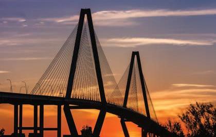
Arthur Ravenel Jr. Bridge Opened in July 2005, this cable-stayed bridge spanning the Cooper River has become an iconic symbol of Charleston. This architectural marvel has a 2-mile bike/pedestrian lane called Wonders’ Way. Free parking is available on East Bay Street in downtown Charleston and also on the Mount Pleasant side at Memorial Waterfront Park, so you can walk the bridge for a bird’s eye view of the Charleston harbor.
Fort Sumter

Fort Moultrie Visit Fort Moultrie on Sullivan’s Island for a greater understanding of history from the American Revolution through World War II. Insider tip: Walk the beach there for stunning views of Fort Sumter and the Charleston skyline from a distance. Address: 1214 Middle St., Sullivan’s Island


Fort Sumter Calling all history buffs! Visit the spot where the first shots of the Civil War were fired. Located in the Charleston harbor, Fort Sumter also played a key role in the Revolutionary War against the British and was Charleston’s main defense from seaside attacks. In 1966, the site was listed on the National Register of Historic Places. You can visit the fort via ferry operated by Fort Sumter Tours. Tours depart from the Aquarium Wharf downtown or at Patriots Point in Mount Pleasant.

Marion Square Spanning more than 6 acres in the heart of downtown Charleston, Marion Square was established as a parade ground for the state arsenal under construction on the north side of the square. It is best known as the former Citadel Green because The Citadel occupied the arsenal from 1843 until 1922, when the military college moved to Charleston’s west side. The name was then changed to Marion Square, in honor of Francis Marion. This city park hosts a number of events and festivals throughout the year. Address: 329 Meeting St., Charleston Old Exchange & Provost Dungeon The old Exchange is a must-see for all Charleston visitors. You will discover this building’s integral role in our country’s quest for independence and its important service to our young nation. The Old Exchange began its existence as a public building and remains so today. Take a tour (admission: $5-$10) to see various aspects of Charleston history during the Colonial and Revolutionary eras.

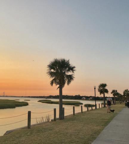

Pitt Street Bridge Once a trolley bridge that connected Sullivan’s Island and Mount Pleasant, the Pitt Street Bridge in Mount Pleasant’s Old Village is a beautiful spot for walking and jogging. Fish from the pier or kayak in the Charleston harbor. The park is also a spectacular spot for catching the sunset with the Ravenel

Bridge in the background. Address: 122 East Bay St., Charleston

Rainbow Row Rainbow Row is the name for a series of colorful historic houses located north of Tradd Street and south of Elliot Street on East Bay Street. It is referred to as Rainbow Row for the pastel colors used to paint the houses. It is a common tourist attraction and is one of the most photographed areas of Charleston. You may hear a number of tales as to why the houses are painted so colorfully. One is so intoxicated sailors coming in from the port could remember which house to bunk in.
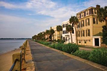
The Battery The Battery is a landmark defensive seawall and promenade in Charleston, famous for its stately antebellum homes. Named for a Civil War coastal defense artillery battery at the site, it stretches along the lower shores of the Charleston peninsula, bordered by the Ashley and Cooper rivers. Address: 2 Murray Blvd., Charleston


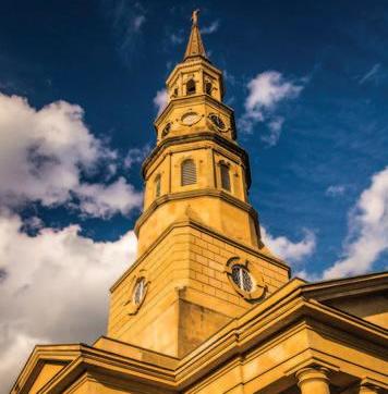
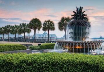
St. Michaels Church & Graveyard St. Michael’s Church is the oldest church edifice in the City of Charleston, standing on the site of the first Anglican Church built south of Virginia. In the 1680s, a small wooden church – the first in the new town of Charles Town – was built on this spot for the families of the Church of England and named St. Philip’s. John Rutledge, the first governor of South Carolina and signer of the Declaration of Independence and U.S. Constitution is buried in the graveyard here. Address: 80 Meeting St., Charleston Riley Waterfront Park Riley Waterfront Park is a 12-acre park along a one-half mile stretch of the Cooper River in Charleston. The public park has a pier with swings and it’s a great place to see some dolphins and snap some photos of the harbor. Be sure to dip your toes in the Pineapple Fountain – another iconic Charleston symbol.

Charles Pinckney National Historic Site Visitor Center Charles Pinckney was a principal author and a signer of the U.S. Constitution. This historic site is a 28-acre remnant of Pinckney's Snee Farm, a rice and indigo plantation. Located on site is an 1828 coastal cottage that serves as a museum and visitor center. Exhibits tell the story of Pinckney and his contributions to the United States as a young and emerging nation as well as detailing 18th-century plantation life for free and enslaved people at Snee Farm. Address: 1254
Long Point Road, Mount Pleasant Address: 1 Vendue Range, Charleston
St. Philips Church & Graveyard Building and graveyard are open to the public Monday to Friday. Established in 1681, St. Philip’s is the oldest religious congregation in South Carolina. The first St. Philip’s Church, a wooden building, was built between 1680 and 1681 at the corner of Broad and Meeting streets on the present day site of St. Michael’s Episcopal Church. It was damaged in a hurricane in 1710 and a new St. Phillip’s Church was begun a few blocks away on Church Street. Address: 146 Church St., Charleston


